12.2 Environmental Legislation, Standards and
Guidelines
12.5 Evaluation of Habitats and Species
12.6 Prediction and Evaluation of Ecological Impacts
12.8 Implementation of Mitigation
12.9 Residual Ecological Impacts
This section presents the assessment of potential ecological impacts
that may arise during the construction and operational phases. With the
implementation of practical mitigation measures, ecological impacts can be
reduced to low levels.
The ecological assessment has been
conducted in accordance with the requirements of Annexes 8 and 16 of the
TM-EIAO as well as the requirements set out under Clause 3.4.13 of the EIA
Study Brief.
12.2 Environmental Legislation, Standards and Guidelines
12.2.1 Local Legislation, Standards and Guidelines
The
relevant legislation and associated guidelines applicable to the present study
for the assessment of ecological impact include:
· Forests and Countryside Ordinance (Cap. 96) and its subsidiary legislation, the Forestry Regulations;
· Wild Animals Protection Ordinance (Cap. 170);
· Environmental Impact Assessment Ordinance (Cap. 499) and relevant annexes 8, 11, 16, 20 and 21 of the associated Technical Memorandum;
· EIA Study Brief No. ESB-238/2011;
· Protection of Endangered Species of Animals and Plants Ordinance (Cap. 586) and its subsidiary legislation.
· Hong Kong Planning Standards and Guidelines (HKPSG) Chapter 10, "Conservation";
· Planning, Environment and Lands Bureau Technical Circular 1/97 / Works Branch Technical Circular 4/97,"Guidelines for Implementing the Policy on Off-site Ecological Mitigation Measures";
· EIAO Guidance Note No. 6/2002 - Some Observations on Ecological Assessment from the Environmental Impact Assessment Ordinance Perspective;
· EIAO Guidance Note No. 7/2002 – Ecological Baseline Survey for Ecological Assessment;
· EIAO Guidance Note No. 10/2004 – Methodologies for Terrestrial and Freshwater Ecological Baseline Survey
· Revised versions of EIAO Guidance Notes 6/2010, 7/2010 and 10/2010 (issued December 2010).
12.2.2 International Conventions and Guidelines
International
conventions and guidelines potentially relevant include:
· Convention on International Trade in Endangered Species of Wild Fauna and Flora ("CITES"). This Convention regulates international trade in certain animal and plant species. Their trade is subject to permits or certificates of origin. Hong Kong's obligations under this Convention are enforced via the Protection of Endangered Species of Animals and Plants Ordinance (Cap. 586).
· IUCN - The World Conservation Union maintains, through its Species Survival Commission, a “Red List” of globally threatened species of wild plants and animals (see http://www.iucnredlist.org/static/introduction).
· United Nations Convention on Biological Diversity. This convention requires parties to regulate or manage biological resources important for the conservation of biological diversity whether within or outside protected areas, with a view to ensuring their conservation and sustainable use. It also requires parties to promote the protection of ecosystems, natural habitats and the maintenance of viable populations of species in natural surroundings. The People’s Republic of China (PRC) ratified the Convention on Biological Diversity on 5th January 1993. The HKSAR Government has stated that it is "committed to meeting the environmental objectives" of the Convention.
12.3.1 Existing Environment
LMC Loop
was the disposal site of mud extracted from the training works for the Shenzhen
River, some of which were contaminated. With the existence of the
potentially contaminated mud, the LMC Loop, in its present form, is not fit for
any use or development. It has been left vacant since its formation.
Adjacent
areas in HK outside the Loop (i.e. Area B and Added Area B as shown in Figure
1.1) are intended to be used to accommodate supporting infrastructure
for the development of LMC Loop. A large part of these adjacent areas falls
within the Frontier Closed Area (FCA) and is therefore characterised by
essentially rural land uses including arable farming and fish ponds.
The
eastern part of these adjacent areas falls entirely within the FCA Boundary.
Its eastern part is on hilly terrain and mainly consists
of unused government land. A few fish ponds are found in the low lying western
part at the foothills.
The
western part of these adjacent areas falls partly within and partly outside the
FCA. Land use inside FCA reflects the restrictive nature of the area and
consists essentially of fish ponds together with the facilities for Boundary
Control Point (BCP) and the MTR LMC Spur Line.
Active
land uses are largely found in the part of the adjacent areas outside the FCA.
A few village settlements, including LMC Tsuen, Pun Uk
Tsuen and Chau Tau Tsuen and Ha Wan Fisherman San Tsuen are mainly surrounded
by arable land and fish ponds.
The area
around the San Tin Interchange is occupied for uses closely
related to the cross-boundary activities. These include open car parks and open
storage compounds for cross-boundary commuters and goods, as well as a public
transport interchange for cross-boundary shuttle bus services.
12.3.2 Ecological Assessment Area
The
Ecological Assessment Area comprises LMC Loop, LMC Meander and the area
initially earmarked for infrastructural links and associated development, the
surrounding assessment area, as required by the EIA Study Brief, and the Ma Tso
Lung area potentially impacted by the Eastern Connection Road. The actual
Ecological Assessment Area in places is more than 500m from the footprint of
proposed Project elements due to the fact that the iterative and prolonged
nature of project formulation raised a number of development options,
assessment of the potential ecological impacts of which required differing
survey areas. The overall survey area was, thus, as inclusive as possible, and
is considered sufficient for all elements of the Project.
For
aquatic ecology, the assessment area is the same as that of water quality
impact assessment, i.e. likely to be impacted by the Project and associated
works. Of particular relevance in respect of aquatic ecology are the following
natural watercourses: LMC Meander, streams draining into the Meander from the
nearby hills and fish pond areas (including Ping Hang Stream), the stream
system running through the Ma Tso Lung area, and a stream near Lung Hau Road
(to the west of LMC Road).
LMC Loop
largely comprises grassland, reed marsh and scattered groups of trees. Adjacent
areas include fish pond and marsh areas of high ecological value at Hoo Hok Wai/Ta
Sha Lok and LMC, as well as the LMC Meander, the original course of the
Shenzhen River prior to training, which now surrounds the LMC Loop on three
sides.
The area
is backed to the south by hilly grassland and shrubland, as well as disturbed
village and village edge habitats, small fragmented areas of shrubland and
woodland; a number of narrow seasonal and permanent streams flow through the
area. Two small areas of wet agricultural fields are present, one at LMC Tsuen
and the other at Chau Tau Tsuen. To the west of the LMC Loop lies the major
infrastructural linkage combining the access road to LMC BCP and the MTR LMC
Spur Line Railway, and beyond a large wetland mitigation area for the latter.
12.3.3 Sites of Conservation Importance
A large part of the Ecological
Assessment Area lies within the Inner Deep Bay and Shenzhen River Catchment
Important Bird Area[1],
which comprises the Mai Po Inner Deep Bay Ramsar Site, outer Deep Bay as far as
Sheung Pak Nai, fish pond and associated wetland areas outside the Ramsar Site
at Nam Sang Wai, San Tin, LMC and HHW, as well as the Ng Tung and Sheung Yue
rivers, including their Long Valley floodplain and the adjacent Ho Sheung Heung
Egretry. The following, more discrete sites of conservation importance are
located in or near the Ecological Assessment Area, and are potentially in the
range of direct, indirect or cumulative impacts.
12.3.3.1 Reed Marsh inside LMC Loop
An area
of 10.96ha of reed marsh lies within the LMC Loop; this comprises 8.7% of reed
marsh in the Deep Bay area. Records of Purple Heron, small bitterns, Eastern
Marsh Harrier, reed warblers and Chinese Penduline Tit [12-30]
indicate this reedbed[2] is
comparable in ecological value to reedbeds elsewhere in the Deep Bay area,
including the long-established reedbed at Mai Po Nature Reserve.
12.3.3.2 Hoo Hok Wai
The area
of Hoo Hok Wai (all references to this area include the immediately adjacent
area of Ta Sha Lok) lies immediately northeast of the Project Area and largely
comprises managed and unmanaged fish ponds and associated wetlands. These
wetlands are of high ecological value and form part of an extensive area of
wetlands extending from Tsim Bei Tsui on the west side of Inner Deep Bay to the
Ng Tung River in the northeast. Significant functional linkages exist with
areas of wetland that form the Mai Po Inner Deep Bay Ramsar Site, which extends
as far as Tsim Bei Tsui. The area provides foraging and roosting grounds that
support a variety of wetland fauna, of which the most significant are
waterbirds and Eurasian Otter. The area is a part of the Deep Bay Wetland Outside Ramsar Site Priority Site for Enhanced Conservation.
12.3.3.3 Lok Ma Chau Meander
The LMC
Meander is the original course of the Shenzhen River and was restored as a
mitigation measure for potential impacts to waterbirds due to the loss of 19ha
of fish ponds as part of Shenzhen River Regulation Project Stage 1 Works. The
meander’s main ecological value appears to arise from its comprising an
important element of the ecological corridor that runs through the area, both
in terms of bird flight lines and mammal movements. The profile and high water
level in the channel appear to limit its ability to function as a foraging
area, though the natural vegetation on either side is used as a roosting area
by waterbirds. In addition, records of Eurasian Otter from in or near the
Meander suggest that it may be of importance to this species.
12.3.3.4 Wetland Conservation and Wetland Buffer Areas
The high
ecological value of fish ponds in the Deep Bay area was highlighted in the
Study on the Ecological Value of Fish Ponds in Deep Bay Area (Aspinwall 1997),
one of the recommendations of which was that an area of fishponds and other wetlands
in the northwest New Territories be designated as a buffer area. As a result,
the Wetland Conservation Area (WCA) and a Wetland Buffer Area (WBA) of 500m
were established. These designations were incorporated into Town Planning Board
guidelines (TPB PG-No. 12B). The planning intents of these two zones as
described in the guideline are as follows:
Wetland
Conservation Area
The
planning intention of the WCA is to conserve the ecological value of the fish
ponds which form an integral part of the wetland ecosystem in the Deep Bay
Area. It comprises the existing and
contiguous, active or abandoned fish ponds in the Deep Bay Area, which should
all be conserved. New development within
the WCA would not be allowed unless it is required to support the conservation
of the ecological value of the area or the development is an essential
infrastructural project with overriding public interest. Any such development
should be supported by an ecological impact assessment to demonstrate that the
development would not result in a net loss in wetland function and negative
disturbance impact. For any redevelopment which requires planning permission
from the Board, an ecological impact assessment would also be required. Wetland compensation is required for any
development involving pond filling and mitigation measures against disturbance
would be necessary. They would be imposed as part of the planning approval
conditions.
Wetland
Buffer Area
The
intention of the WBA is to protect the ecological integrity of the fish ponds
and wetland within the WCA and prevent development that would have a negative
off-site disturbance impact on the ecological value of fish ponds. A buffer
area of about 500m along the landward boundary of the WCA is thus designated as
a WBA. As a substantial amount of the fish ponds within the WBA have already
been lost over time through filling and certain areas have been degraded by the
presence of the open storage use, these degraded areas may be considered as
target areas to allow an appropriate level of residential/recreational
development so as to provide an incentive to remove the open storage use and/or
to restore some of the fish ponds lost.
The fish ponds, wet agricultural land and shrubland in the southern side of the Project Area are included within the WCA and the WBA designated by the Town Planning Board Guideline 12B, though not LMC Loop itself.
12.3.3.5 MTR Lok Ma Chau Spur Line Wetland Mitigation Area
The MTR LMC Spur Line Wetland Mitigation Area (LMC WMA) is located approximately 800m to the west of LMC Loop (see Appendix 12-12, plate 39). The LMC WMA occupies an area of approximately 36ha, and comprises managed freshwater wetland habitat. Enhancement of the LMC WMA to provide wetland habitat conforming to criteria set out in the Habitat Creation and Management Plan for the wetland is a requirement of the Environmental Permit for the Sheung Shui to LMC Spur Line project. Ecological monitoring of the LMC WMA to monitor target wildlife species and other species of conservation importance using the LMC WMA in order to demonstrate that mitigation targets are being achieved has occurred since July 2002. The site also includes a wastewater treatment reedbed. Figure 12.1 shows the location of LMC WMA.
12.3.3.6 Riparian Corridor at Ma Tso Lung
The natural streams of the Ma Tso Lung area include a vegetated riparian corridor from where there is a single record of Three-banded Box Terrapin, made during fieldwork for NENT NDA PES. Hong Kong supports the world’s largest remaining wild population of this critically endangered species (KFBG 2010).
12.3.3.7 San Tin East Main Drainage Channel
Project 73CD San Tin East Main Drainage Channel (STEMDC) comprises a drainage channel 2.2km in length along the west side of San Sham Road (see Appendix 12-12, plate 37) from Castle Peak Road to Shenzhen River, a low-flow pumping station, an inflatable dam, associated roads and drainage works, landscaping works and a compensatory constructed wetland between the drainage channel and the access road to LMC BCP. The shortest distance to LMC Loop is approximately 486m. Associated ecological monitoring for the initial three years of the operational period has recorded low numbers of a suite of waterbirds typical of such habitats, including Greater Painted-snipe.
12.3.3.8 Ho Sheung Heung Egretry
Ho Sheung
Heung Egretry is one of the largest and longest-lived egretries in Hong Kong,
and the number of breeding birds approximately doubled between 1994 and 2007.
Previously, the egretry was occupied in order of importance by Chinese Pond
Herons, Little Egrets and Cattle Egrets, and supported one of the largest
colonies of Chinese Pond Herons in the SAR [12-7]. However, species
composition has changed in recent years. In 2011, it supported 6.5% of Hong
Kong’s breeding ardeids [12-13], comprising 38 Little Egret nests,
12 Cattle Egret nests and only two Chinese Pond Heron nests, while in 2012 it
supported 5.8% of Hong Kong’s breeding ardeids, comprising 33 Little Egret
nests, four of Chinese Pond Heron and 12 of Cattle Egret. The nearest distance
to LMC Loop is 2860m, though Crest Hill lies between the two closest points.
12.3.3.9 Mai Po Inner Deep Bay Ramsar Site
Lying at its nearest point approximately 2.0km southwest of LMC Loop, the Mai Po Inner Deep Bay Ramsar Site covers about 1,500ha of intertidal, brackish and freshwater wetland, including the Mai Po Marshes SSSI and Inner Deep Bay SSSI. The Ramsar Site was designated as a “Wetland of International Importance” under the Ramsar Convention on 4 September 1995. Comprising extensive intertidal mudflats, mangrove, gei wai and fishponds, it supports a variety of habitats and high faunal diversity. The site supports over 100,000 waterbirds each year, and there are records of 36 globally-threatened and near-threatened species (as listed by IUCN and BirdLife International as of December 2011), including four that are Critically Endangered and three that are Endangered, the latter including Black-faced Spoonbill, a substantial proportion of the world population of which forages and roosts largely within the Ramsar Site in the winter months.
12.3.3.10 Mai Po Nature Reserve
The Mai Po Nature Reserve (MPNR) is located approximately 3.5 km southwest of LMC Loop. It lies within the Mai Po Marshes SSSI, which was designated in 1976. Since 1983, World Wide Fund for Nature Hong Kong has managed approximately 380ha of the Nature Reserve in partnership with the HKSAR Government. The reserve provides valuable foraging and roosting habitat for a variety of fauna, and is especially important to waterbirds, including the globally threatened Black-faced Spoonbill.
12.3.3.11 Mai Po Village Egretry
The Mai Po Village Egretry SSSI is located adjacent to the village of the same name, though it has spread to include adjacent and somewhat separate colonies at Mai Po Lung. The shortest distance from LMC Loop to these egretries is approximately 2386m. Most birds using this egretry forage in wetlands at Mai Po Nature Reserve and fishponds in the Mai Po and at San Tin, though it is possible some also forage in the area of LMC Loop.
12.3.3.12 Fu Tian National Nature Reserve
Situated
along the northern shore of Deep Bay, Fu Tian National Nature Reserve is
located about 5 km west of LMC Loop. The Nature Reserve was established in 1984
and comprises 815ha of fish ponds, shrimp ponds, mangrove swamps and mudflats,
including the sea grass Halophila sp.
The faunal species utilizing the area are very similar to those at MPNR and,
like the latter, it is important to large numbers of
waterbirds. The Reserve also contains a mangrove area that provides feeding and
nursery grounds for many commercially important crustacean and fish species for
nearby oyster and fish farms in Deep Bay.
12.3.4 Species of Conservation Importance
The
composition of species of conservation importance recorded inside the LMC Loop
is largely determined by the relative lack of areas of open water, which are
the characteristic feature of much of the rest of the Deep Bay area. Lack of
human access also results in much lower levels of human disturbance than is
present in most of the Deep Bay area. The presence of grassland and, in
particular, Phragmites reed marsh,
means that the focus of faunal interest concerns grassland and
reedbed-associated birds. This suite of species includes Purple Heron, small
bitterns, Eastern Marsh Harrier, reed warblers and Chinese Penduline Tit, all
wetland-associated species of conservation significance. Section 12.4.4 provides details of bird species known to have been
recorded in the Ecological Assessment Area, and indicates which are of
conservation concern.
In contrast, the adjacent fish pond wetland areas
at HHW and LMC support large numbers of large waterbirds such as Grey Heron,
Great, Little and Cattle Egrets, Chinese Pond Heron, Black-crowned Night Heron
and Black-faced Spoonbill. In addition, ducks and shorebirds occur in low to
moderate numbers in wetland areas near the LMC Loop, primarily the fish pond
areas but also in the remaining areas of wet agriculture. Imperial and Greater
Spotted Eagles occur in the fish pond area, as do Red-billed Starlings; none of
these species frequent the LMC Loop commonly, however, as the habitat appears
unsuitable. In the case of the former, LMC Loop is unsuitable due to the lack
of open-water habitat that would support its main prey, ducks. In the case of
Red-billed Starling, this is an open-country species that forages at fruiting
trees, fish ponds, wet agricultural areas, drainage channels and the edge of
reed beds where there is open ground (Carey et
al. 2001); these habitats are absent or hardly present in the Loop. Numbers
of the two eagles at HHW are much reduced, apparently due to a decline in duck
farming [12-22]. Greater Painted-snipe has been reported from LMC
Loop, but the habitat appears unsuitable for breeding. Occasional passage
migrants are, however, likely to occur throughout the LMC Loop and HHW area.
In the hills
between LMC Tsuen and Ma Tso Lung Tsuen there exists an avifaunal community
typical of hilly grassland habitats in Hong Kong. Of primary interest in this
area is Eurasian Eagle Owl, which is listed by Fellowes et al. (2002)[12-31]
as of Regional Concern, and is a second grade protected species in China [12-73].
In terms of
non-bird fauna, four are of particular significance. The first is
Eurasian Otter Lutra lutra, of which one
record from the reedbed in LMC Loop and one from the LMC Meander were obtained
during fieldwork carried out for this Study, in addition to its being reported
by local people to occur there. It also occurs in adjacent areas, primarily HHW
and LMC. Eurasian Otter is of conservation significance (‘Near Threatened’ -
IUCN; ‘Endangered’ - CSIS), and the Hong Kong distribution of this protected
species appears to be confined to the northwest New Territories[12-66].
Given the paucity of records from adjacent areas in China, the population may
be of regional significance.
A network of
natural streams flows from the hills into the Ma Tso Lung area. A recent record
of Three-banded Box Terrapin here indicates this species may occur in natural
stream and woodland/shrubland in the area. This species is near extinction [12-15],
and is regarded as Critically Endangered both worldwide [12-38] and
in China [12-30]. According to KFBG (2010) Hong Kong supports the last known large wild
population of this species in the world.
Burmese
Python is listed as Critically Endangered in China by CSIS (2010) [12-30],
as Near-threatened globally by IUCN (2010) [12-38] and as of
Potential Regional Concern by Fellowes et
al. (2002) [12-31]. It is a Class I Protected Species in China,
but is widely distributed in Hong Kong. ENSR (2009) [12-30a]
recorded an individual in the shrubland alongside the boundary fence road,
while local villagers reported that this species appears inside LMC Loop and in
LMC Meander. Burmese Python is likely to occur in the Assessment Area, as it
has been regularly recorded inside LMC WMA (AEC 2009) [12-1].
The fish Rose
Bitterling has been recorded in a stream next to Lung Hau Road. This is only
the third site in Hong Kong where it has been recorded, and the species is
listed as of Local Concern by Fellowes et
al. (2002)[12-31].
12.4.1 Pre-existing Data and Information Gaps
There
was a limited amount of data regarding the ecology of LMC Loop available prior
to the commencement of this Study. The most recent and largest data gathering
activity occurred from March 2008 to February 2009 [12-30a], and
this provided the primary background reference for the LMC Loop. Surveys for
that study were carried out as follows:
· Habitat and vegetation: March, July and December 2008.
· Avifauna: March 2008 to February 2009, monthly.
· Mammals: March 2008 to January 2009, every two months.
· Herpetofauna: March to September 2008, monthly.
· Odonata and butterflies: February to November 2008, monthly.
· Freshwater organisms: July 2008.
In
addition, the EIA Study for the Construction of a Secondary Boundary Fence and
new sections of Primary Boundary Fence and Boundary Patrol Road [12-52]
provided some relevant data, as did data collected for LUPCAFS. Finally, faunal
data relevant to the Shenzhen River were provided by SESRC (2009) [12-68].
A
greater amount of data are available for the rest of the Ecological Assessment
Area, however, as these areas have been the subject of a number of ecological
studies, including ecological impact assessment and monitoring for designated
projects such as Lok Ma Chau Spur Line and STEMDC, planning studies, ongoing
waterbird monitoring as part of the Mai Po Inner Deep Bay Ramsar Site Waterbird
Monitoring Programme (WBMP), and other work carried out by academics and
amateurs.
12.4.1.1 Avifauna
The data available in ENSR (2009) [12-30a] and Mott Macdonald (2009) [12-52] for avifauna in the Ecological Assessment Area were assessed to be accurate based on the known status and distribution of birds in Hong Kong [12-22] and the Deep Bay area in particular. No unexpected species were recorded. However, in general there was insufficient detail for an ecological impact assessment for such a project as this, and further surveys were deemed necessary regarding certain issues.
12.4.1.2 Mammals
Results documented in Shek (2006) [12-66] and Shek et al. (2007) [12-67], based on surveys carried out between 2002 and 2006 represent the most systematic mammal survey data available in HK. Although mammal surveys were also conducted within and around the LMC Loop area by ENSR (2009) [12-30a] from March 2008 to February 2009, no species of high conservation concern, in particular Eurasian Otter, were recorded. In view of this, further investigation of the occurrence of this species in the area was deemed necessary.
12.4.1.3 Herpetofauna
ENSR (2009)
conducted a detailed survey for herpetofauna (from April to November 2008 for
reptiles and from March to September 2008 for amphibians) in the LMC Loop and
areas within 500m. The species recorded in the LMC Loop were typical of the
Deep Bay area, with no unexpected records. Given that habitat characteristics
of the site remain the same as at that time, and that the area is underlain by
potentially contaminated mud that might affect environmental quality, it was
considered highly unlikely that the herpetofauna community would have changed
in the interim. However, site visits to confirm current site conditions were
carried out, as well as surveys to validate that the faunal community remains
similar to that previously described.
Herpetofauna surveys were also conducted in areas near the LMC Loop (from May to August 2008 at Ha Wan Tsuen, LMC San Tsuen and HHW and from March to June 2009 at Ma Tso Lung) during the LUPCAFS and NENT NDA PES. All these surveys were conducted at the most appropriate time (i.e. wet season, night-time for frogs) and applied survey methodologies (i.e. detecting mating calls, searching at microhabitats) suggested in the EIAO Guidance Notes 07/2002 and 10/2004. In these studies, nearly all lowland amphibians and certain reptile species that typically appear in lowlands (c.f. Reels et al. 1995[12-61], Karsen et al. 1998[12-40] and Chan et al. 2005[12-27]) were recorded. Consequently, it was considered that herpetofauna data from certain sites of the present Ecological Assessment Area, such as LMC Loop and Ha Wan Tsuen, LMC Tsuen and certain parts of HHW, should be up-to-date and comprehensive.
12.4.1.4 Odonata
As with
herpetofauna, the odonate data available for the LMC Loop were assessed as
representative and accurate because the data collected are relatively recent
and the findings comparable to those of other studies carried out in similar
habitats in the Deep Bay area (i.e. Wilson 1995[12-76], AEC 2008[12-1]).
It was considered that present surveys should be concentrated on areas that
have not previously been examined in detail (i.e. HHW and Ma Tso Lung).
12.4.1.5 Butterflies
Habitats
contained within LMC Loop comprise reedbed and relatively poor quality and
degraded lowland grassland and plantation. These habitats generally support a
relatively low diversity of butterfly species in Hong Kong. Based on comparison
with data from other parts of the Deep Bay area, including the LMC WMA, it was
considered that the results from previous surveys in LMC Loop are
representative of the species occurring in the LMC Loop. Consequently, it was
not considered necessary to conduct regular surveys in LMC Loop, although
surveys to confirm no change in the overall butterfly community were carried
out in 2009 and 2010, and butterflies observed during surveys for other groups
were recorded where possible. This work confirmed that the butterfly community
of LMC Loop remains relatively impoverished, and is, broadly speaking,
accurately reflected in ENSR (2009) [12-30a].
Surveys in
adjacent areas have previously been conducted by ENSR (2009) [12-30a],
the EIA Study for the Construction of a Secondary Boundary Fence and new
sections of Primary Boundary Fence and Boundary Patrol Road [12-52]
and LUPCAFS. The habitats present in adjacent areas are more suitable for
butterflies than those within the LMC Loop itself, and consequently the
diversity of butterfly species recorded is also higher.
12.4.1.6 Aquatic Fauna
Given
the polluted nature of the water in and around the LMC Loop, the data presented
by SESRC (2009)[12-68], which
revealed a highly impoverished aquatic community in the Shenzhen River, and
ENSR (2009) [12-30a], which recorded low diversity in the LMC
Meander, are considered to be representative. Survey efforts were thus concentrated on other aquatic bodies of the
Ecological Assessment Area.
12.4.1.7 Data Gaps
Given the
predominance of reed marsh and grassland habitats in LMC Loop, more detailed
information regarding usage by birds of these habitats was required in order to
assess ecological value and predict and evaluate impacts caused by their loss.
The
primary data gap was that concerning flight lines used by birds in the area
(including the LMC Loop, LMC Meander and adjacent fish ponds). The only
relevant data were those relating to Great Cormorants flying toward the HHW
area in a 5-year period up to 2005 [12-10]. However, this study only
surveyed the number of cormorants, and no other large waterbird species, nor
factors such as the area over which birds flew or the height of flight.
Accurate assessment of these was required in order to assess the potential
impact of development in the LMC Loop and associated supporting infrastructure.
The
numbers and distribution of fauna in the potentially impacted fish ponds and
associated wetlands at HHW relevant to this Study also required specific
survey, as ongoing and previous work did not cover the exact spread of ponds.
While
ENSR (2009) [12-30a] carried out surveys for mammals, no records of
Eurasian Otter were obtained. This is not surprising as it is a difficult
species to effectively survey. Sight records from the area, the presence of
suitable habitats and a relative lack of disturbance did, however, suggest
there may be a reasonable population. Consequently, further survey work, though
of a different nature, was considered necessary.
The LMC
Meander constitutes a mitigation area for fish pond loss as a result of the
training of the Shenzhen River. However, it does not appear to have been
comprehensively surveyed by previous studies, and further fieldwork was
considered necessary to determine its importance to birds, in particular.
While
the grassy hills between LMC Tsuen and Ma Tso Lung Tsuen were surveyed
previously, issues arising from any road connection to the LMC Loop through
this area needed to be specifically addressed, especially in relation to
natural streams. Consequently, appropriate fieldwork was carried out.
Construction
of the Western Connection Road had potential impacts on wet agriculture and
marsh near LMC Tsuen and Chau Tau Tsuen. Some of these areas had not been
surveyed in recent years, and fieldwork was required to fill this gap.
Provision of the Eastern Connection Road through the Ma Tso Lung area also
required targeted surveys, particularly with regard to natural stream corridors
potentially suitable for Three-banded Box Terrapin.
With
regard to butterflies, previous surveys were not sufficient to fully describe
the importance of areas outside LMC Loop potentially impacted by road
construction. Field surveys were conducted to assess the importance of these
areas for butterflies.
Aquatic
surveys had been conducted in the natural water bodies in the aquatic
assessment area; however, usually only food fishes and exotic species were
recorded. Although these results may simply reflect the history of the area as
a centre of fish farming, it was considered necessary to explore natural
aquatic habitats, especially natural streams, around LMC Loop.
With
regard to wetland habitats west of the LMC BCP, in view of the significant ecological
barrier provided by San Sham Road and the MTR LMC Spur Line viaduct, as well as
the fact that the LMC WMA is intensively monitored in respect of its EP
targets, it was not considered necessary to carry out survey work in this area
(see Appendix 12-16 for list of
faunal species recorded). With regard to STEMDC, existing data arising from
monitoring work carried out by AFCD and, formerly, by the Study Team, meant
that survey work was not considered necessary (see Appendix 12-17 for list of bird species recorded).
12.4.2 Survey Methodology
The
surveys undertaken were designed to provide an ecological baseline description
sufficient to meet the requirements of the EIAO that impacts can be predicted,
described and, where possible, quantified. Thus, the surveys were designed not
only to fill the data gaps listed above, but also collect other relevant
baseline data.
Below a summary is provided of the fieldwork carried out. Most surveys were carried out during the period between June 2009 and May 2010 (see Table 12-2). Surveys for fireflies, however, were carried out in the 2012 wet season (see Section 12.4.4.7). Transect routes and count locations for the various ecological surveys conducted are presented in Figure 12.2.
Table 12.2 Schedule of field survey activities
(2009-2010).
|
Month |
Jun |
Jul |
Aug |
Sep |
Oct |
Nov |
Dec |
Jan |
Feb |
Mar |
Apr |
May |
|
Habitat mapping |
|
x |
|
|
x |
x |
|
|
|
|
|
|
|
Botanical survey |
|
x |
|
|
x |
x |
|
|
|
|
|
|
|
Birds |
x |
x |
x |
x |
x |
x |
x |
x |
x |
x |
x |
x |
|
Bats |
|
|
|
|
x |
|
|
|
|
|
x |
|
|
Mammals |
x |
x |
x |
x |
x |
x |
x |
x |
x |
x |
x |
x |
|
Herpetofauna |
x |
x |
x |
x |
x |
|
|
|
|
x |
x |
x |
|
Dragonflies |
x |
x |
x |
x |
x |
|
|
|
|
x |
x |
x |
|
Butterflies |
x |
x |
x |
x |
x |
|
|
|
|
|
x |
x |
|
Aquatic fauna |
|
|
x |
x |
|
|
|
|||||
Detailed
methodologies and results of ecological baseline field works are provided in Appendices 12-1 to 12-11.
12.4.2.1 Avifauna
Surveys of
avifauna comprised the following elements:
a) in LMC Loop, monthly point counts at 13 locations were carried out along two transects through accessible areas of the key habitats, targeting the reed marsh in particular;
b) to obtain a more accurate picture of usage of reedbed and grassland habitats in the LMC Loop, specifically in relation to the Phragmites-associated species that are most likely to be impacted by reed marsh loss, bird trapping sessions (under licence from AFCD) using mist-nets were carried out;
c) flight lines through the area were surveyed once monthly from April to September and twice-monthly from October to March;
d) with regard to LMC Meander, five-minute point counts were carried out at three locations: the two points where the meander meets/approaches the Shenzhen River, and at a point along the southern section;
e) fish ponds east of the LMC BCP surrounding the LMC Loop were surveyed on foot along a standard transect for birds once-monthly;
f) monthly transect surveys of the Ma Tso Lung area were carried out.
12.4.2.2 Mammals
Any
observations of mammals or their signs, including Eurasian Otter, made while
carrying out other surveys were recorded. When carrying out bird surveys in fish
ponds and associated wetlands in particular, searching for otters in the field,
given its habitat preferences and behaviour, is a natural extension of the
field work. However, given the infrequency of sighting animals in the field, it
was considered that questioning people frequently present in the area was
potentially a productive method for obtaining a better understanding of otter
distribution. Consequently, a questionnaire survey of local fish pond operators
was carried out in an effort to determine locations that otters might favour.
The
placing of camera traps in the area was considered as a method of survey, but
based on experience of the Study Team at LMC WMA, it was considered the chances
of success were low, especially as the relative homogeneity of wetland (reed
marsh) and other habitats in LMC Loop would have made choosing suitable
locations for cameras largely a matter of chance. Furthermore, the difficulty
of access to the reed marsh meant there were significant safety issues, which
were considered sufficient to preclude both the placing of camera traps and
searching for otter holts. Camera traps for the HHW
area were also considered, but rejected due to the high probability of theft
(again, based on experience of the Study Team at LMC WMA). While ponds at HHW
are generally relatively undisturbed, there is more human activity near LMC
Loop than elsewhere, and the disappearance of cameras was considered a real
possibility. In the event, otter was recorded on two occasions during field
surveys, which, given the difficulties of surveying this species, is considered
reasonably successful.
Surveys
of bats using a bat detector were carried out in October and April (the early
dry season and early wet season). As far as possible, bats were identified
according to echolocation call structure.
12.4.2.3 Herpetofauna
Surveys
of herpetofauna followed the methodology described in EIAO
Guidance Note No. 10/2004 and 10/2010. These surveys were carried
out in the months of March to October.
12.4.2.4 Odonata
Surveys
of herpetofauna followed the methodology described in EIAO
Guidance Note No. 10/2004 and 10/2010. These surveys were carried
out in the months of March to October.
12.4.2.5 Butterflies
Surveys
of butterflies followed the methodology described in EIAO Guidance Note 10/2004
and 10/2010. These surveys were carried out between the months of April and
October. The hills above Ma Tso Lung and LMC were
surveyed to check for hill-topping individuals of species that may be
under-recorded in the lowland areas.
12.4.2.6 Aquatic Fauna
Surveys
of aquatic fauna mainly relied on direct observation, since most
water bodies within the area are polluted. Nevertheless, subject to water
quality, netting/ trapping was carried
out where required. Surveys were
conducted once in the wet season (August to October) and once in the dry season
(November to February).
12.4.3 Habitats and Flora Baseline
Figure 12.1 illustrates the habitats in the
Ecological Assessment Area, Appendix
12-1 details the methodology and results of field surveys and Appendix 12-12 provides photos of
habitats. Findings are divided into three areas: LMC Loop, the adjacent area in
HK outside LMC Loop excluding the third area, Ma Tso Lung. The latter is
separated out due to its nature being different from areas outside the boundary
fence in lacking extensive areas of pond and reed marsh.
12.4.3.1 LMC Loop
ENSR
(2009) [12-30a] and Mott Macdonald (2009) [12-52]
identified five (grassland, reedbed, watercourse, village/orchard and abandoned
fish pond) and two (abandoned agricultural land/low-lying grassland and marsh)
habitats within LMC Loop respectively. LMC Loop is mainly dominated by
grassland and reed marsh (regarded as “Marsh” in Mott Macdonald (2009)
[12-52]) areas that have developed in the last decade (ENSR 2009)
[12-30a]. In the current ecological baseline study, eight habitats were
identified within LMC Loop, as follows: reed marsh, marsh, grassland,
grassland/shrubland, orchard, plantation, channelized watercourse and
urban/residential area.
a) Reed Marsh
Reed
marsh areas generally result from the invasion of Phragmites spp. into low-lying areas where water is retained. This
is one of the dominant habitats within the LMC Loop, covering an area of
10.96ha. Continuous and extensive areas of reed marsh are located in the
central and southern parts of the LMC Loop, mainly along both sides of the
channelized watercourse (Appendix 12-12,
plate 1). This habitat is dominated by reed Phragmites
australis, but contains a small amount of P. karka. A few examples of the herb Abelmoschus moschatus were recorded in this habitat. Abelmoschus moschatus is regarded as a
restricted species found in lowland forest margins and wasteground [12-77],
but is not of conservation significance.
b) Marsh
Three
small marshy areas, which appear to have formed as a result of differential
settlement of soils, occupy a total of 0.5ha (Appendix 12-12, plate 2). Water quality is poor. A few wetland
plant species (such as Ludwigia
octovalvis, Eleocharis dulcis, Phragmites australis and Mariscus umbellatus) are present along
the edges, while the water surface is covered with the floating aquatic herb Pistia stratiotes and the grass Brachiaria mutica.
c) Grassland
LMC Loop
is largely covered by extensive grassland (56.56 ha) that has established
through natural succession (Appendix
12-12, plate 3). Dominated by grassy vegetation (such as Brachiaria mutica, Panicum maximum and Imperata
koenigii) and other herbs and creepers (including Bidens alba, Mimosa pudica, Sesbania spp.,
Eupatorium catarium, Ipomoea cairica and Mikania micrantha), it is of low floral value.
d) Grassland/Shrubland
Grassland/shrubland
(14.62ha in LMC Loop) comprising shrubs (such as Melastoma candidum, Ficus
hispida, Bridelia tomentosa and Lantana camara) and trees (such as Macaranga tanarius, Sapium sebiferum and Leucaena
leucocephala) are commonly found in patches in the extensive grassland (Appendix 12-12, plate 3). This
floristic composition is very similar to that recorded in ENSR (2009)
[12-30a].
e) Orchard
A small
orchard (0.96ha) planted with low numbers of Common Banana Musa x paradisiaca is
present at the southern fringe of the LMC Loop, though it has received minimal
human management.
f) Plantation
Plantation
consists of tree clumps dominated by exotic tree species (primarily Acacia confusa, Leucaena leucocephala and Acacia
mangium) and a few self-sown trees (such as Macaranga tanarius, Bischofia
javanica, Celtis sinensis and Melia azedarach). These tree clumps are
scattered across the extensive grassland and occupy a total of 1.70ha of land
within the LMC Loop (Appendix 12-12,
plate 4).
g) Channelised Watercourse
A channelized
watercourse is present in the northeast of LMC Loop, running from the reed
marsh area toward the Shenzhen River. As noted above, much of it is occupied by
reeds.
h) Urban/Residential Area
This refers to the
vehicular track that runs along the edge of LMC Loop adjacent to Shenzhen
River.
12.4.3.2 Adjacent Area in HK outside LMC Loop
Previous
studies[12-30a] [12-52] did not
survey all relevant parts of the adjacent area, and thus only 11 habitats were
described, namely ponds, marsh, stream/river/drainage channel, wet agricultural
land, hillside grassland, shrubland, plantation, woodland, village/orchard and
developed area. No rare or protected species were recorded. In the current
study, 18 habitats were identified in adjacent areas in
HK outside LMC Loop, near the Western Connection Road, Direct Link to LMC
Station and the Flushing Water Service Reservoir.
a) Pond
Pond is
the major habitat type in the adjacent area (35.91ha in the Ecological
Assessment Area) and is ecologically of the most significance (Appendix 12-12, plate 5). However, the
botanical significance of these ponds is limited, based on the work of ENSR
(2009) [12-30a], Mott Macdonald (2009) [12-52] and
surveys for the current study, with only common and widespread species present
(46 species recorded by Ove Arup (2009) [12-57]). They are mostly vegetated with
herbaceous species (such as grass Brachiaria
mutica, Chloris barbata and Panicum maximum, and other herbs
including Ipomoea aquatica, Wedelia trilobata and Bidens alba)
along the pond bund. A few naturally established trees (including Ficus hispida, Macaranga tanarius, Celtis
sinensis and Sapium sebiferum)
and fruit trees (such as Dimocarpus
longan, Litchi chinensis and Musa x paradisiaca) are also present along the pond bund.
Some
ponds are overgrown with herbaceous vegetation such as the grasses Brachiaria mutica and Panicum maximum, and other herbaceous
creepers including Ipomoea cairica, Ipomoea aquatica and Mikania micrantha.
b) Reed Marsh
A small
reedbed (dominated by Phragmites
australis and Phragmites karka) adjacent to MTR LMC Station is used for
polishing effluent from the secondary treatment plant for the station and
associated facilities (illustrated in Appendix
12-12, plate 38). A few small patches of reed and marsh habitat are present
in areas adjacent to San Sham Road, close to LMC Control Point, and to the southeast
corner of the LMC Loop, while a continuous strip of annually-cut reeds has
developed along the southern bank of the Shenzhen River for much of the length
of the Ecological Assessment Area (Appendix
12-12, plate 10). This habitat, which occupies a total of 9.36ha of land,
is dominated by Phragmites australis
and Phragmites karka, while other
wetland vegetation such as Aster
subulatus, Alternanthera sessilis and
Commelina diffusa were also recorded.
c) Marsh
Marsh
areas are present in a low-lying area/pond alongside LMC Meander to the
southeast of LMC Loop and northwest of Chau Tau Tsuen (Appendix 12-12, plate 7). This habitat occupies 3.35ha of land, and
is dominated by herbaceous vegetation (including grass Brachiaria mutica, Leersia
hexandra and Panicum paludosum,
and other herbs Cyclosorus interruptus,
Colocasia esculenta and Ipomoea cairica). Low numbers of wetland
herbs such as Cyperus spp., Phragmites australis and Ludwigia octovalvis are also present. The dominance of herbaceous species (such as herbs
Bidens alba, climbers Ipomoea cairica, Mikania
micrantha and Wedelia trilobata,
and grasses Panicum maximum and Paspalum conjugatum) indicates that part
of these marsh areas have been disturbed and are in the process of drying up
(Yip et al. 2010).
d) Mitigation Wetland
A
section of mitigation wetland for STEMDC lies within the Ecological Assessment
Area, occupying 1.27ha of land between LMC BCP and the river channel. The area
is dominated by common herbaceous vegetation, such as grass Brachiaria mutica and Imperata koenigii, and the herbs Bidens alba, Ipomoea cairica, Ipomoea aquatica and Aster
subulatus. This marshy area is extensively covered by
herbaceous vegetation (such as Commelina diffusa, Ipomoea cairica,
Bidens alba and Neyraudia reynaudiana). Tree groups comprising weedy tree Leucaena
leucocephala and other common tree species such as Acacia confusa and
Macaranga tanarius are also present.
Mitigation wetland adjacent to MTR LMC Station
comprises managed fish ponds, marshes and reedbed. The bunds of the fish ponds
are vegetated with the grasses Panicum
maximum and Brachiaria mutica.
Wetland plants planted in marshy ponds (including herbs such as Bacopa monnieri, Commelina diffusa, Cyperus
malaccensis, Polygonum barbatum
and Polygonum glabrum) at the time of wetland construction
have been gradually enriched by self-sown plants (such as herbs Cyperus imbricatus, Cyperus exaltatus and Polygonum
lapathifolium and trees Macaranga
tanarius, Melia azedarach and Sapium sebiferum). The floristic
diversity in this mitigation wetland is comparatively higher than other
mitigation wetlands in the area.
e) Natural Watercourse
Natural
watercourse includes LMC Meander (Appendix
12-12, plate 9), its riparian vegetation and a few overgrown natural
streams close to LMC; total area is 17.18ha. Common and weedy grassy vegetation
(such as Brachiaria mutica and Panicum maximum) and wetland herbs
(including Commelina diffusa, Cyperus malaccensis and Phragmites australis) predominate.
Isolated shrubs and trees (such as Lantana
camara, Ficus hispida, Leucaena leucocephala and Macaranga tanarius) are present along
the Meander. Many of the small
streams in this area are polluted to some extent, often with domestic sewage.
f) Channelised Watercourse
Channelised
watercourses constituting 23.55ha primarily comprise Shenzhen River and small
channels in the area of LMC, as well as STEMDC (Appendix 12-12, plate 8). These watercourses are concrete-lined
with limited floristic diversity along the channel (dominated by Phragmites spp. along the Shenzhen
River, and other grassy vegetation including Brachiaria mutica and Panicum
maximum in other channelized watercourses). The Shenzhen River is heavily polluted.
g) Wet Agricultural Land
A small
area (1.29ha) of wet agricultural land is present at LMC Tsuen (Appendix 12-12, plate 12). This habitat
is dominated by common herbaceous vegetation such as Alocasia odora, Colocasia
esculenta, Ipomoea aquatica, Ipomoea batatas (ENSR 2009[12-49a];
Mott Macdonald 2009[12-52]; the current botanical survey). Isolated shrubs (such as Lantana camara) and trees (such as Ficus hispidsa and Macaranga tanarius) are also present in this habitat.
Adjacent to Chau Tau Tsuen there is a small
area (2.77ha)
of wet agricultural land. More intensively managed than the area next to LMC
Tsuen and with little in the way of inactive fields, it is cultivated with Ipomoea aquatica, Nasturtium officinale and patches of Colocasia esculenta. The bunds are vegetated with common grasses (Brachiaria mutica and Cynodon dactylon) and herbs (such as Bidens alba, Kyllinga monocephala and Portulaca oleracea).
h) Seasonally Wet Grassland
A small area
of seasonally wet grassland is present to the southwest of Chau Tau Tsuen,
occupying a total of 1.68ha of land. It is mainly covered with herbaceous
vegetation (including grass Brachiaria
mutica, Panicum maximum and Paspalum conjugatum, and other herbs Bidens alba, Alocasia odora, Ipomoea aquatica and Wedelia
trilobata). Limited wetland species were identified, including Phragmites australis, Colocasia esculenta, and Ludwigia octovalvis.
i) Grassland
Fire-maintained
hillside grassland (25.61ha) is present at Ping Hang, to the southeast of the
LMC Loop (Appendix 12-12, plate 13).
This grassland is mainly dominated by common and widespread species such as the
fern Dicranopteris pedata and grasses
such as Miscanthus sinensis, Imperata koenigii and Neyraudia reynaudiana. Shrubs/small
trees (such as Rhus hypoleuca, Rhus succedanea, Rhodomyrtus tomentosa, Breynia
fruticosa and Desmodium heterocarpon)
and trees (such as Cratoxylum
cochinchinense, Aporusa dioica and
Pinus massoniana) are also present.
j) Grassland/Shrubland
A small,
disturbed area of 1.85ha of grassland/shrubland is present to the southeast of
Ha Wan Tsuen. It is mainly covered by common grassy vegetation, weedy herbs and
common tree species such as Litchi
chinensis, Lagerstroemia speciosa, and
Syzygium jambos, with Leucaena leucocephala at the fringes.
k) Secondary Woodland
Scattered
patches of secondary woodland totalling 8.46ha are present in the hillside area
behind Chau Tau Tsuen, Pun Uk Tsuen, Ha Wan Fisherman San Tsuen and Ha Wan
Tsuen (Mott Macdonald, 2009[12-52]; the current study). Mature trees
such as Ficus microcarpa, Mallotus paniculatus, Microcos paniculata, Schefflera heptaphylla and
Sterculia lanceolata are common in these woodlands. The understorey is
dominated by common species such as Psychotria
asiatica, Ligustrum sinense, Uvaria macrophylla and Litsea rotundifolia var. oblongifolia. Exotic fruit trees such as Dimocarpus
longan and Litchi chinensis are
commonly planted close to the woodland fringe by the villagers.
The secondary woodland behind Chau Tau and Pun Uk Tsuen was regarded as fung shui wood in previous studies (Binnie Black & Veatch 2002 [12-18]; Babtie Asia Ltd. 2004[12-16] but not in Chu (1998) [12-28] or Yip et al. (2004) [12-78]. This woodland supports moderate floristic diversity[12-18], and is ecologically and botanically linked with woodland fragments in adjacent areas, and share similar botanical features, including saplings of the protected species Aquilaria sinensis.
A
sapling of the protected native tree Aquilaria
sinensis was recorded at the fringe of the secondary woodland adjacent to
the access road to LMC Tsuen. A few seedlings and mature tree specimens of this
protected tree were also recorded in the secondary woodland close to Pun Uk Tsuen. This species is common in lowland forest and fung shui woods, but is locally
protected under Cap. 586. Mature, large tree specimens of Cinnamomum camphora were identified in the secondary woodland close
to Pun Uk Tsuen. These trees lie outside the area of impact for the Project.
l) Plantation
Roadside
screening and ornamental plantation stands are present to the northeast of MTR
LMC Station and along Castle Peak Road, occupying a total of 1.29ha of land.
Common shrubs (such as Duranta erecta,
Calliandra haematocephala and Hibiscus rosa-sinensis) and plantation
trees (such as Casuarina equisetifolia,
Cassia surattensis, Lagerstroemia speciosa, Hibiscus tiliaceus and Acacia confusa) predominate.
m) Shrubland
A small
area of hillside shrubland of 3.68ha is present close to Ping Hang (Appendix 12-12, plate 13) and Ha Wan
Fisherman San Tsuen. The hillside shrubland is ecologically linked with the
adjoining hillside terrestrial habitats (i.e. grassland, secondary woodland and
other shrubland fragments) and supports more diverse and abundant shrubby
plants than grassland. It contains the common shrubs Rhodomyrtus tomentosa, Clerodendrum
cyrtophyllum, Callicarpa kochiana,
Rhus chinensis and Rhaphiolepis indica and some isolated
tree species Cratoxylum cochinchinense
and Sapium discolor. A sapling of the
protected native tree species Aquilaria
sinensis was identified at the shrubland fringe next to the vehicular road
to LMC Lookout .
n) Village Area
Village
areas totalling 3.05ha are present close to Pun Uk
Tsuen, at Ha Wan Tsuen (illustrated in Appendix
12-12, plate 27) and close to the Police checkpoint along LMC Road. Trees
(such as fruit trees Dimocarpus longan,
Mangifera indica, Musa x paradisiaca and Litchi chinensis, and
others such as Ficus benjamina, Albizia lebbeck and Bischofia javanica) have been planted by villagers for landscaping
and economic purposes (ENSR 2009[12-30a]; the current study). Other
naturally established grass and woody species were also recorded, but in
limited numbers and most are under management.
o) Urban/Residential Area
Urban/Residential
area, comprising MTR LMC Station and associated infrastructure (Appendix 12-12, plate 40), roads,
public facilities and car parks, occupies 45.74ha of land. Ornamental shrubs
(such as Duranta erecta, Ixora coccinea and Calliandra haematocephala) and trees (such as Cassia surattensis,
Casuarina equisetifolia and Spathodea
campanulata) are present. Limited self-sown vegetation was recorded in this
urban/residential area, including common shrubs/small trees (such as Lantana camara, Macaranga tanarius and Ficus
hispida) and trees (such as Leucaena
leucocephala, Ficus microcarpa, Celtis sinensis and Cinnamomum camphora). Mature, large tree specimens of Celtis sinensis are also present.
p) Waste Ground
A very
small area (0.85ha) of waste ground opposite to the Police checkpoint along LMC
Road is covered by weedy herbaceous vegetation such as Bidens alba, Mimosa pudica and grasses Brachiaria
mutica and Cynodon dactylon.
In addition, very
small areas of dry agricultural land and orchard are present, in close
association with village areas. These are dominated by cash crop species and
are of low ecological value.
12.4.3.3 Ma Tso Lung Area
Ten
habitats have been identified in the Ma Tso Lung area, near the proposed
alignment of the Eastern Connection Road. These comprise secondary woodland,
marsh, grassland, plantation, pond, seasonally wet grassland, orchard, village
area, urban/residential area and
watercourse.
a) Marsh
A small marsh developed from low-lying abandoned agricultural land is
present to the southwest of Shun Yee San Tsuen; this is ecologically linked
with adjacent seasonally wet grassland. It supports limited but typical
floristic diversity, with the marshy area mainly covered by the fern Cyclosorus interruptus and grasses (Panicum maximum and Brachiaria mutica). Other wetland-associated herbs, including Alternanthera sessilis, Commelina diffusa, Ludwigia perennis, Ludwigia
octovalvis and Colocasia esculenta,
are also present. In addition,
marsh habitat is also present along the boundary fence road between Shun Yee
Tsuen and Horn Hill. This marsh habitat has lower quality than the marsh
southwest of Shun Yee Tsuen and it has been overgrown by common herbaceous
vegetation such as climber Mikania micrantha and Ipomoea cairica,
grass Brachiaria mutica and other herbs Commelina diffusa and Colocasia esculenta.
b) Pond
Several small ponds are present to the south of Ma Tso Lung Tsuen, and
the bunds are dominated by common grasses such as Brachiaria mutica and herbs such as Bidens alba and Mikania micrantha. A small
number of ponds lie alongside the boundary fence road. and
these are typical fish ponds with pond bunds mainly covered by common grasses Brachiaria
mutica and Panicum maximum and herbs Bidens alba.
c) Seasonally Wet Grassland
A rather extensive area of seasonally wet grassland developed from
abandoned agricultural land is located to the southwest of Shun Yee San Tsuen (Appendix 12-12, plate 15). This low-lying area supports limited
wetland-associated plant species. It is extensively covered by common weedy
grass (such as Brachiaria mutica, Panicum maximum and Pennisetum alopecuroides), other herbs (such as Commelina diffusa and Cyclosorus interruptus) and herbaceous
creepers (such as Ipomoea cairica and
Mikania micrantha). A few isolated
shrubs and trees (such as Ficus hispida,
Macaranga tanarius and Mangifera indica) are also present. A
small number of fruit trees Musa x paradisiaca are present within and along
the edge of this habitat.
d) Grassland
Hillside grassland to the northeast of Shun Yee San Tsuen is similar in
floristic composition and diversity to grassland identified near Ping Hang.
e) Secondary Woodland
Hillside secondary woodland to the north of Ma Tso Lung supports a
closed and continuous canopy dominated by mature and large tree species
(including Celtis sinensis and Dimocarpus longan). Common secondary
woodland herbs (including Alocasia ordora
and Liriope spicata), shrubs/small
trees (such as Psychotria asiatica, Ficus hirta, Litsea rotundifolia var. oblongifolia,
Ligustrum sinense and Bridelia tomentosa) and trees (such as Mallotus paniculatus, Microcos paniculata, Phyllanthus emblica, Aporusa dioica and Litsea glutinosa) are present in this secondary woodland, as well
as a single sapling of the protected Aquilaria
sinensis (data from NENT NDA PES and from current study). This secondary
woodland is ecologically linked with adjacent terrestrial hillside habitats
(i.e. grassland and shrubland) and provides wildlife habitat and a seed source
for the succession of other terrestrial habitats.
a) Orchard
A few small-sized orchards are scattered around the Ma Tso Lung area and
are mainly associated with villages. These mainly comprise common fruit trees,
including Dimocarpus longan, Mangifera indica, Litchi chinensis and Prunus persica,
for economic purpose. This habitat type is actively managed, with only limited
herbaceous vegetation established naturally.
b) Plantation
A number of plantation stands are present in the area. Unlike roadside
plantations that are largely planted with ornamental trees and shrubs under
intensive management, these are largely dominated by mature fruiting and native
trees. The overstorey largely comprises Dimocarpus
longan and Syzygium jambos, and native trees (including Celtis sinensis, Cinnamomum camphora and Microcos
paniculata), but the understorey is limited in floristic diversity,
comprising a few common herbs Alocasia
odora and Mikania micrantha,
grass Imperata koenigii and
shrubs/small trees Psychotria asiatica,
Ficus hispida and Ficus hirta. These plantation stands are
usually protected by the villages. Ecologically, it provides semi-closed canopy
for wildlife utilization, but its understorey composition is simpler than
natural secondary woodland.
c) Village Area
Several village areas (Ma Tso Lung San Tsuen, Shun Yee San Tsuen and
scattered village houses in Ma Tso Lung) are present. Vegetation recorded in
these villages has usually been planted by villagers (such as fruit trees Mangifera indica, Clausena lansium and Musa x
paradisiaca, and ornamental trees Thuja orientalis and Acalypha wikesiana). Naturally
established species are also present, including herbs (Bidens alba, Euphorbia hirta and Emilia
sonchifolia), shrubs and trees (such as Bridelia
tomentosa, Ficus microcarpa, Michelia x alba and Microcos paniculata). Vegetation identified in this habitat is
common and widespread.
d) Urban/ Residential Area
Urban/Residential area includes roads, Lo Wu Firing Range, public
facility and a school. Vegetation in this habitat is limited and comprises common
and ornamental species similar in composition to other anthropogenic areas.
e)
Watercourse
Watercourses are
found at Ma Tso Lung and Tse Koo Hang. That at Tse Koo Hang is largely natural but the water level can be very low in winter, and it was dry
during the dry season survey. In Ma Tso Lung
Stream there is always a considerable water level throughout the year. Although
this stream is also largely natural, it receives untreated sewage from nearby
village houses and contains many
exotic species. However, stream water quality is still not very bad and species
of high conservation concern were
recorded in an upper section during survey for the NENT NDA PES.
Riparian zones of these two streams are mostly
natural, except for some
areas alongside Ma Tso Lung Stream where village houses are located. The lower
section of this stream has recently completed
channelization by DSD using ecologically-friendly methods (i.e. using stone gabion and maintaining a
semi-natural streambed). Both streams drain into marshy areas at Hoo
Hok Wai. The streams are mainly
vegetated by herbaceous plants, including Colocasia esculenta, Alocasia
macrorrhizos, Alternanthera sessilis, Commelina diffusa and Panicum
maximum.
12.4.4 Fauna Baseline
Figure 12.2
shows the transect routes, pond numbers, point count locations and flight line
count locations for surveys.
12.4.4.1 Avifauna
Scientific
names for avifauna are provided in Appendix 12-2, which provides a list of all bird species recorded in the whole
assessment area for ecology, together with typical habitat utilisation. Nomenclature and taxonomy follow
Carey et al. (2001) [12-22]
and subsequent updates published in the HKBR
up to 2010.
Flight Line Surveys
a) Literature Review
The only relevant data are those relating
to Great Cormorants flying toward the HHW area in a 5-year period up to 2005 [12-10]. During this period, up to 2,627 or 27.5% of the wintering
population of Great Cormorants were recorded at LMC Lookout flying to HHW from
LMC.
b) Survey Results
Methodology and results of the flight line surveys are contained in Appendix 12-3, while Figures A12-1 - A12-21 in Appendix 12-3 illustrate the main findings of the surveys. The main conclusions to be drawn from these surveys are as follows:
· in the figures above, it can be seen that the main area of the flight line corridor is concentrated over LMC Meander, an area up to approximately 150m wide in the immediately adjacent part of LMC Loop (170m at the widest point) and the fish ponds on the opposite side to a width of approximately 50m;
· entry to the LMC Loop area is concentrated in the vicinity of Ha Wan Tsuen in winter and between Ha Wan Tsuen and the junction of Lung Hau Road (see Appendix 12-12, plate 22) with LMC Road in the wet season;
· access to the HHW fish pond area is concentrated in the area near Ngau Kok Shan where the eastern section of LMC Meander parallel to the border fence turns northwest toward Shenzhen River;
· the Shenzhen River is used as a minor focus of flight lines, with 8.8% of bird-flights recorded over the channel;
· relatively few birds fly directly over the central part of LMC Loop;
· the overall distribution of flight heights is influenced by the presence or absence of anthropogenic or natural features. Thus, flight heights are in general highest in the southwest, where there is higher ground, the MTR LMC Spur Line and the BCP, and lowest in the east and northeast, where largely only fish ponds lie adjacent;
· the distribution of flight lines to HHW is more concentrated than those in the opposite direction to LMC, though the overall focus on LMC Meander is broadly similar;
· Great Cormorants in particular use the Meander as a strong focus for their flight lines. The distribution of Great and Little Egrets is somewhat broader, with both occurring relatively more often over the interior part of LMC Loop and the Shenzhen River. Chinese Pond Herons show some preference for the Meander, but this may be due to a preference for fish ponds rather than the Meander per se, as this species does not generally carry out such long flights to and from foraging areas.
· the distribution of Black-faced Spoonbill flight lines is also focused on LMC Meander, though probably less significantly than other species;
· HHW continues to support an important element of the regionally significant Deep Bay area non-breeding population of Great Cormorant;
· a significant proportion of the Deep Bay population of Great and Little Egrets utilises the HHW area in certain months;
· the HHW area appears to be of greater importance to Great Egrets, possibly because it is relatively undisturbed, which would be attractive to such a large and relatively disturbance-sensitive species.
LMC Loop
a) Literature Review
ENSR
(2009)[12-30a] recorded the
following species of conservation significance in the LMC Loop: Purple Heron,
Little Egret, Chinese Pond Heron, Imperial and Greater Spotted Eagles, and
Chinese Penduline Tit. The dearth of open water habitat explains the lack of
large waterbird species such as Great Cormorant, Grey Heron and Great Egret,
despite their abundance in nearby wetland areas. In contrast, species such as
Purple Heron, Chinese Pond Heron and Chinese Penduline Tit favour vegetated wetlands and have occurred in appropriate habitats
in the LMC Loop, which is dominated by grassland and reed marsh.
The
only other species of conservation significance recorded by ENSR (2009)
[12-30a] in habitats common in the LMC Loop is Zitting Cisticola, which
occurs in grassland areas. This is a scarce breeding species in Hong Kong,
primarily confined to the northwest New Territories [12-22], and is
listed by Fellowes et al. (2002)
[12-31] as of Local Concern.
b) Survey Results
Methodology and
results of transect surveys, point counts and mist-netting surveys relevant to
LMC Loop are provided in Appendices 12-4
and 12-5.
The
trapping and point count surveys carried out for this Study have confirmed the
presence of all the species mentioned in previous literature, as well as other reed
marsh-associated species. A list of species of conservation concern recorded
utilising LMC Loop (i.e. not simply flying over) and the habitats in which each
was recorded is provided in Table 12.3,
together with an indication of their conservation status.
Table 12.3
Avifauna of conservation concern recorded in LMC Loop and habitat
utilisation.
|
Species |
Habitat |
Conservation Status |
||
|
Global |
HK |
China |
||
|
Great Cormorant 鸕鷀 |
Plantation |
|
PRC |
|
|
Grey Heron 蒼鷺 |
Plantation |
|
PRC |
|
|
Purple Heron 草鷺 |
Reed
Marsh |
|
RC |
|
|
Great Egret 大白鷺 |
Plantation |
|
PRC(RC) |
|
|
Intermediate Egret 中白鷺 |
Grassland |
|
RC |
|
|
Little Egret 小白鷺 |
Pond |
|
PRC(RC) |
|
|
Cattle Egret 牛背鷺 |
Grassland |
|
(LC) |
|
|
Chinese Pond Heron 池鷺 |
Pond |
|
PRC(RC) |
|
|
Black-crowned Night Heron 夜鷺 |
Plantation |
|
(LC) |
|
|
Yellow Bittern 黃葦鳽 |
Reed Marsh |
|
(RC) |
|
|
Cinnamon Bittern 栗葦鳽 |
Reed Marsh |
|
LC |
|
|
Black Kite 黑鳶 |
Plantation |
|
(RC) |
|
|
Pied Harrier 鵲鷂 |
Reed
Marsh |
|
LC |
|
|
Eastern Marsh Harrier 白腹鷂 |
Reed
Marsh |
|
LC |
|
|
Pheasant-tailed Jacana 水雉 |
Pond |
|
LC |
|
|
Wood Sandpiper 林鷸 |
Pond |
|
LC |
|
|
Pintail/Swinhoe’s Snipe 針尾/大沙錐 |
Pond,
Grassland |
|
LC* |
|
|
Lesser Coucal 小鴉鵑 |
Grassland |
|
|
2 |
|
Pied Kingfisher 斑魚狗 |
Pond |
|
(LC) |
|
|
White-throated Kingfisher 白胸翡翠 |
Pond |
|
(LC) |
|
|
Red-throated
Pipit 紅喉鷚 |
Pond,
Grassland |
|
LC |
|
|
Bluethroat 藍喉歌鴝 |
Reed
Marsh |
|
LC |
|
|
Pallas's Grasshopper
Warbler 小蝗鶯 |
Reed
Marsh |
|
LC |
|
|
Zitting
Cisticola 棕扇尾鶯 |
Reed
Marsh, Grassland |
|
LC |
|
|
Golden-headed
Cisticola 金頭扇尾鶯 |
Grassland |
|
LC |
|
|
Chinese
Penduline Tit 中華攀雀 |
Reed
Marsh |
|
RC |
|
|
Chestnut-eared
Bunting 栗耳鵐 |
Grassland |
|
LC |
|
|
Yellow-breasted
Bunting 黃胸鵐 |
Reed Marsh |
V |
RC |
|
|
Yellow-billed
Grosbeak 黑尾蠟嘴雀 |
Plantation |
|
LC |
|
|
Red-billed
Starling 絲光椋鳥 |
Plantation |
|
GC |
|
|
White-cheeked
Starling 灰椋鳥 |
Plantation |
|
PRC |
|
|
White-shouldered
Starling 灰背椋鳥 |
Plantation |
|
(LC) |
|
|
Black-naped
Oriole 黑枕黃鸝 |
Plantation |
|
LC |
|
|
Collared Crow白頸鴉 |
Plantation |
|
LC |
|
Note:
[1] Global conservation status assessments are those of IUCN/BirdLife International (www.birdlife.org), Hong Kong assessments are from Fellowes et al. (2002); categories are LC=Local Concern, RC=Regional Concern, GC=Global Concern, P=Potential, while those in parentheses indicate the assessment is on the basis of restrictedness in breeding and/or roosting sites rather than in general occurrence. Listing as 1st or 2nd grade protected species in China is from Wang (1998). * Species generally inseparable in field; conservation status assessment refers to G. megala.
Although almost the full suite of egrets and herons regularly recorded
in HK was noted during surveys, the number of individuals was low (no more than
two individuals of each), and species such as Great Cormorant, Grey Heron and
Great Egret were recorded roosting in trees, not foraging. The low number of
individuals is due to the lack of open water habitat, and LMC Loop is not
considered to be an important site for these species.
Two
of the waterbird species listed, however, are reed-associates: Purple Heron,
and Yellow Bittern. Purple Heron was recorded twice, once in the reedbed and
once foraging in LMC Meander. Yellow Bittern, despite being a fairly common
summer visitor and autumn migrant through reedy wetland areas in HK, was only
recorded once in the reedbed. The low number of records of these species, in
addition to the absence in winter of Great Bittern, indicates that reed marsh
in LMC Loop is not as high in terms of ecological value as the managed reedbed
at Mai Po NR, which supports higher numbers of all these species.
With regard
to non-waterbird species of conservation concern, both trapping (four
individuals) and point count (peak count four) surveys recorded good numbers
throughout the winter period of Bluethroat, while point counts recorded good
numbers (peak count 27) of Chinese Penduline Tit; both of these are passerine
species of conservation concern, the former rated as of Local Concern and the
latter of Regional Concern by Fellowes et
al. (2002) [12-31].
The two
cisticolas were recorded in grassland and reedbed habitats, with Golden-headed
favouring grassland and Zitting showing no marked preference in the
non-breeding season.
The only
globally-threatened passerine species recorded (as defined by BirdLife
International) was Yellow-breasted Bunting, of which four were recorded in reed
marsh habitat in October (one trapped, the remainder seen). This habitat may be
of some significance to this species at a local level.
The
mist-netting surveys provided re-trap records (i.e. individual birds trapped
again in later trapping periods) that indicated some passage migrants (e.g.
Oriental Reed Warbler and Black-browed Reed Warbler) remained in the area,
using the reed marsh as a stopover during migration to build up fat reserves
before continuing their migratory journey. In addition, a Dusky Warbler trapped
on 21st October was subsequently retrapped on 29th
October at Mai Po NR, indicating some degree of connection between the two
sites for migrant passerines. This connectivity was also indicated by
observations of Pied and Eastern Marsh Harriers that could be individually
identified by their plumage leaving a nocturnal roost in the LMC Loop reed
marsh and the same birds seen at Mai Po NR around the same time.
In terms of
other species listed in Table 12.3,
the number of individuals recorded was not so high as to suggest habitats in
LMC Loop are important.
LMC Meander
a) Literature Review
No records of birds could be traced in the literature that directly referred to LMC Meander, probably because such reports have been subsumed in broader area designations such as HHW or LMC. However, members of the study team have noted in past years its use as both a foraging and roosting area by such species as Little Grebe, Great Cormorant, Grey Heron, Great Egret, Little Egret, Chinese Pond Heron and Black-crowned Night Heron.
b) Field Surveys
Table A12-13 in Appendix 12-5 lists the species recorded in LMC Meander. It continues to provide roosting and foraging areas for small numbers of the large waterbirds listed above. Fish in the Meander provide foraging opportunities for piscivorous species, while the dense vegetation along the banks provide suitable daytime roosting conditions for species such as Black-crowned Night Heron and Great Cormorant. In addition, a Purple Heron was recorded in October foraging in dense vegetation along the northern section of the Meander, while an Imperial Eagle was recorded there midwinter. Water quality is not poor, as is the case in the Shenzhen River.
Wetlands in the LMC and HHW Areas
a) Literature Review
The
fishpond areas that extend east from San Sham Road comprise much of HHW are of
particular importance for wetland birds due to a combination of suitable
habitat and a relative lack of fragmentation and disturbance. Approximately
140ha or 19% of the Ecological Assessment Area outside LMC Loop comprises
fishponds.
The
waterbirds of these areas are comparatively well known due to the Mai Po Inner
Deep Bay Ramsar Site Waterbird Monitoring Programme (WBMP) carried out by the
Hong Kong Bird Watching Society (HKBWS) since the early 1990s (funded by
Agriculture, Fisheries and Conservation Department (AFCD) under service
contract arrangement). Knowledge of landbird usage of the site has been
acquired from Carey et al. (2001)
[12-22], various issues of the HKBR
and by inference from surveys carried out in other fishpond areas of the
northwest NT.
Wetland-dependent
bird species are the primary constituent of the ecological significance of
fishpond areas in the northwest New Territories, and the fishponds located
within the Ecological Assessment Area are no different (see Appendix 12-5). Of particular note are
breeding, passage and wintering populations of large waterbirds, including
egrets, herons, duck and spoonbills. Significant numbers of the
globally-threatened Black-faced Spoonbill occur at the MTR LMC Spur Line WMA,
while smaller numbers occur at HHW. Strong linkages exist between HHW and the
wetland areas to the west of LMC BCP, including the intertidal areas of Inner
Deep Bay, as confirmed by radio-telemetry studies of Black-faced Spoonbills [12-8]
and flight line counts of cormorants[12-10].
The
WBMP includes surveys of 77 fish ponds that lie in the area from LMC BCP to HHW
(survey area ‘Shenzhen River B’). In terms of the total area of fishponds east
of the LMC BCP (185.29ha), approximately 50% of these ponds (93.14ha) are
surveyed each month.
In terms
of overall numbers, the highest counts of waterbirds are made in the winter
months, with the five highest counts of birds having occurred in the months
January to March. These counts lay in the range 879-1063 birds and constituted
15.7% to 48.7% of the total number of waterbirds recorded in fishpond areas of
Deep Bay in the same months (Table 12.4).
Table 12.4 The five
highest counts of waterbirds at HHW (Shenzhen River B) in the HKBWS/AFCD Mai Po
Inner Deep Bay Ramsar Site WBMP since December 1998, and the percentage each count
comprises of the total Deep Bay fish pond count of waterbirds.
|
Date |
Deep Bay fish pond area
count |
HHW Count |
Percentage of Deep Bay
fish pond count |
|
March 2001 |
2183 |
1063 |
48.7% |
|
February
1999 |
4430 |
966 |
21.8% |
|
February
2004 |
3523 |
960 |
27.2% |
|
January 2005 |
5920 |
927 |
15.7% |
|
January 2002 |
2889 |
879 |
30.4% |
From
December 1998 to June 2009 the number of waterbirds recorded at HHW averaged 15.1%
of the total for all fishponds surveyed in the Deep Bay area. As might be
expected given the higher levels of disturbance and smaller pond size, the
fishponds lying along the southeast edge of the LMC Loop (pond numbers 1-39
alongside Ha Wan Tsuen Road and the boundary fence road) supported a
proportionately lower (by approximately 40%) number of waterbirds than the
ponds in the core area of HHW itself, where disturbance levels are lower, pond
size is larger and habitat diversity is greater.
As noted
above, HHW provides an important foraging area for egrets and herons during
both the breeding and non-breeding seasons. Previously, the area was known to
be an important foraging area for Chinese Pond Herons breeding at the Ho Sheung
Heung egretry [12-14], although its significance in this respect
appears to have declined in recent years, with approximately 25% (compared with
48% in 1995 [12-14]) recorded flying to this area in the 2009
breeding season (field work for NENT NDA PES). During field work conducted for Agreement No. PLNQ 73/2011 Ecological Field
Survey of Hoo Hok Wai in the 2012 breeding season, approximately 36% of
flight lines from the egretry headed toward HHW.
The HHW
area is also an important foraging ground for the Hong Kong wintering population
of Great Cormorants. The most recent data available concern winter 2004-05,
when up to 2627 birds or 27.5% of the then wintering population was recorded
flying to forage in fishponds at HHW[12-10].
Imperial
and Greater Spotted Eagles, both listed as globally threatened species by
BirdLife International, occur regularly in Hong Kong only in the Deep Bay
wetlands. Previously, these birds frequently occurred at HHW; however,
apparently as a result of a decline in duck farming in the area, they are now only
occasionally recorded there [12-22]. Both, however, were recorded by
ENSR (2009) [12-30a] and during fieldwork for this study in the LMC
Loop.
The
reedbed-associated species recorded by ENSR (2009) [12-30a] in the LMC
Loop (Purple Heron and Chinese Penduline Tit) also occur in reedbeds at HHW,
though less commonly. The reed areas at HHW are in general drier and more
fragmented; however, they have strong ecological linkage with adjacent wetland
habitats, in particular freshwater marsh.
b) Field Surveys
Data from field surveys confirmed the continued importance of HHW to waterbirds (see Appendix 12-5). Black-faced Spoonbill was recorded foraging at ponds during draindown, along with Grey Heron, Great and Little Egrets, and Chinese Pond Heron. There were no records of either of the two globally-threatened eagles during the transect surveys, though an Imperial was recorded over LMC Meander (see above). While these eagles do still occur in the LMC Loop and HHW area, as noted above, their numbers appear to have declined significantly. Bluethroat was regularly recorded in marsh, dense grassy vegetation and reedy areas at the margins of ponds during the winter months, and in Marsh 1 at HHW. Chinese Penduline Tit, however, was recorded only once in Marsh 1, indicating the poorer quality of the reed areas compared with that in LMC Loop.
The overall
distribution of waterbirds in the area as recorded during transect surveys is
illustrated in Figures A12-22-25. Fewest waterbirds
were recorded in the fish ponds along Ha Wan Tsuen Road to the southwest of LMC Loop and the boundary fence road to the southeast. These ponds are generally small in size, more
disturbed, support less habitat diversity and, in the case of those along Ha
Wan Tsuen Road, generally long inactive with a profile unfavourable to
waterbird access. The exception were ponds 11, 12 and 21, which regularly held
roosting cormorants; in addition, up to 13 Black-faced Spoonbills were
regularly reported foraging in pond 12 (illustrated in Appendix 12-12, plate 31) in winter 2011-12. Highest numbers of waterbirds in the ponds surveyed were
concentrated in fish ponds to the northeast of LMC Loop.
In terms of
non-waterbird species in fish pond areas, the typical suite of resident species
present is common and widespread throughout HK and regionally, and not of
conservation significance. Migrant passerines occurred during the autumn,
winter and spring seasons, typically comprising wagtails, pipits, warblers,
buntings and starlings. Most of these occurred in the more extensive, open fish
pond areas, however, rather than in the area of Ha Wan Tsuen Road and the
boundary fence road, where the area of ponds is narrow and rather more closed
due to the presence of shrubs and trees. Passerine species (other than the
common and widespread species mentioned above) recorded along Ha Wan Tsuen Road
comprised Plaintive Cuckoo, White Wagtail, Olive-backed Pipit, Common
Stonechat, Yellow-browed Warbler, Little Bunting, Yellow-billed Grosbeak, Scaly-breasted Munia
and Red-billed and White-shouldered Starling.
All
species of conservation concern recorded at HHW both in the literature and
during the current study are listed in Table
12.5.
Table 12.5 Species of conservation significance
recorded at HHW and their status at HHW and in HK.
|
Species |
BirdLife |
Fellowes et al. |
Status in HHW (HK) |
|
Little Grebe 小鸊鷉 |
|
LC |
Common all
year (1) |
|
Great Cormorant 鸕鷀 |
|
PRC |
Common
winter visitor (2) |
|
Grey Heron 蒼鷺 |
|
PRC |
Present all year
(1) |
|
Great Egret大白鷺 |
|
PRC(RC) |
Common all
year (1) |
|
Little Egret小白鷺 |
|
PRC(RC) |
Common all
year (1) |
|
Cattle Egret 牛背鷺 |
|
(LC) |
Common all
year (1) |
|
Chinese Pond Heron池鷺 |
|
PRC(RC) |
Common all
year (1) |
|
Striated Heron 綠鷺 |
|
(LC) |
Rare summer
visitor (5) |
|
Black-crowned
Night Heron 夜鷺 |
|
(LC) |
Common all
year (1) |
|
Black-faced Spoonbill黑臉琵鷺 |
E |
PGC |
Occ. winter
records (2) |
|
Eurasian Wigeon 赤頸鴨 |
|
RC |
Rare (2) |
|
Falcated Duck 羅紋鴨 |
NT |
RC |
Rare (4) |
|
Common Teal 綠翅鴨 |
|
RC |
Scarce (2) |
|
Chinese Spotbill 斑嘴鴨 # |
|
RC |
Rare (4) |
|
Northern Pintail針尾鴨 |
|
RC |
Scarce (2) |
|
Northern Shoveler琵嘴鴨 |
|
RC |
Scarce (2) |
|
Tufted Duck 鳳頭潜鴨 |
|
LC |
Scarce (2) |
|
Red-breasted
Merganser 紅胸秋沙鴨 |
|
LC |
Rare (4) |
|
Osprey 鶚 |
|
RC |
Scarce (1) |
|
Black Kite 黑鳶 |
|
(RC) |
Common all
year (1) |
|
Greater Spotted Eagle烏鵰 |
V |
GC |
Previously
regular, now rare (4) |
|
Imperial Eagle白肩鵰 |
V |
GC |
Previously
regular, now rare (4) |
|
Eurasian Coot 白骨頂 |
|
RC |
Small
numbers in winter (4) |
|
Bonelli's Eagle 白腹山鵰 |
|
(RC) |
Regular
visitor (1) |
|
Eurasian Hobby 燕隼 |
|
(LC) |
Scarce
migrant (6) |
|
Eurasian Coot 白骨頂 |
|
RC |
Scarce in
winter (2) |
|
Pheasant-tailed
Jacana 水雉 |
|
LC |
Scarce
migrant (6) |
|
Greater
Painted-snipe 彩鷸 |
|
LC |
Scarce
migrant (5) |
|
Black-winged Stilt黑翅長腳鷸 |
|
RC |
Regular,
winter and passage (3) |
|
Pied Avocet反嘴鷸 |
|
RC |
Rare in
winter (2) |
|
Oriental
Pratincole 普通燕鴴 |
|
LC |
Passage
migrant (6) |
|
Grey-headed
Lapwing 灰頭麥雞 |
|
LC |
Rare migrant
(4) |
|
Pacific Golden
Plover 太平洋金斑鴴 |
|
LC |
Scarce (3) |
|
Little Ringed
Plover 金眶鴴 |
|
(LC) |
Present all
year (1) |
|
Kentish Plover環頸鴴 |
|
RC |
Rare on
passage (2) |
|
Greater Sand
Plover 鐵嘴沙鴴 |
|
RC |
Rare on
passage (6) |
|
Spotted Redshank鶴鷸 |
|
RC |
Scarce (3) |
|
Marsh Sandpiper澤鷸 |
|
RC |
Scarce (3) |
|
Common
Greenshank 青腳鷸 |
|
RC |
Scarce (3) |
|
Wood Sandpiper 林鷸 |
|
LC |
Present all
year (3) |
|
Pintail/Swinhoe’s
Snipe 針尾/大沙錐 |
|
LC* |
Scarce
migrant (3) |
|
Red-necked Stint
紅頸濱鷸 |
|
LC |
Scarce (3) |
|
Temminck's Stint
青腳濱鷸 |
|
LC |
Scarce (3) |
|
Long-toed Stint 長趾濱鷸 |
|
LC |
Scarce (3) |
|
Dunlin黑腹濱鷸 |
|
RC |
Rare on
passage (2) |
|
Ruff 流蘇鷸 |
|
LC |
Scarce (3) |
|
Black-headed
Gull 紅嘴鷗 |
|
PRC |
Scarce (3) |
|
Pied Kingfisher 斑魚狗 |
|
(LC) |
Present all
year (1) |
|
White-throated
Kingfisher白胸翡翠 |
|
(LC) |
Present all
year (1) |
|
Oriental Skylark
小雲雀 |
|
LC |
Rare (6) |
|
Citrine Wagtail 黃頭鶺鴒 |
|
LC |
Rare (3) |
|
Red-throated
Pipit 紅喉鷚 |
|
LC |
Common (3) |
|
Buff-bellied
Pipit 黃腹鷚 |
|
LC |
Rare (3) |
|
Bluethroat 藍喉歌鴝 |
|
LC |
Scarce (2) |
|
Pallas's
Grasshopper Warbler 小蝗鶯 |
|
LC |
Scarce (3) |
|
Styan’s Grasshopper Warbler 史氏蝗鶯 |
V |
GC |
One record
(Aspinwall 1997) (4) |
|
Zitting Cisticola
棕扇尾鶯 |
|
LC |
Present all
year (1) |
|
Golden-headed
Cisticola 金頭扇尾鶯 |
|
LC |
Scarce (1) |
|
Chinese Penduline Tit中華攀雀 |
|
RC |
Regular in
winter (2) |
|
Chestnut-eared
Bunting 栗耳鵐 |
|
LC |
Scarce (3) |
|
Yellow-breasted Bunting黃胸鵐 |
V |
RC |
Regular in
winter and on passage (3) |
|
Japanese Yellow
Bunting 硫黃鵐 |
V |
GC |
Rare (6) |
|
Yellow-billed
Grosbeak 黑尾蠟嘴雀 |
|
LC |
Regular all
year (1) |
|
Red-billed Starling絲光椋鳥 |
|
GC |
Common in
winter (2) |
|
Purple-backed
Starling 北椋鳥 |
|
LC |
Scarce (6) |
|
White-cheeked Starling 灰椋鳥 |
|
PRC |
Common in
winter (2) |
|
White-shouldered
Starling 灰背椋鳥 |
|
(LC) |
Present all
year (1) |
|
Black-naped
Oriole 黑枕黃鸝 |
|
LC |
Scarce (6) |
|
Collared Crow白頸鴉 |
NT |
LC |
Common all
year (1) |
Notes:
[1] BirdLife International: E = Endangered, V = Vulnerable, NT = Near-threatened. Fellowes et al. (2002): RC = Regional Concern, GC = Global Concern, PGC = Potential Global Concern. * species generally inseparable in field, conservation status for G. megala. # indicates change in taxonomic treatment since Carey et al. (2001).
[2] HK status: 1: present all year; 2: winter visitor; 3: winter visitor and passage migrant; 4: scarce winter visitor; 5: present all year, mainly summer; 6: mainly passage migrant.
Wet Agricultural areas at LMC Tsuen and Chau Tau Tsuen
a) Literature Review
There are very few records from LMC Tsuen in the literature, as its location in the Closed Area has restricted access for many years. Chau Tau Tsuen, however, was regularly visited in the 1980s and 1990s (though it was referred to as Lok Ma Chau in the HKBR).
Greater Painted-snipe, a rare breeding species in Hong Kong and listed as of Local Concern by Fellowes et al. (2002) [12-31], was recorded in active and inactive wet agricultural fields at LMC Tsuen during fieldwork for the LUPCAFS and by ENSR (2009) [12-30a]. It was also recorded in similar habitat adjacent to Chau Tau Tsuen up to ten years ago. At the same time were also present a suite of freshwater wetland associated species such as smaller ardeids, snipe, sandpipers, Little Ringed Plover, and pipits and wagtails.
b) Field Surveys
Results of field surveys are provided in Appendix 12-5. The wet agricultural area at LMC Tsuen appears to have changed relatively little over the past 20 years, especially in comparison to Chau Tau Tsuen (see below). The suite of species recorded is typical of such areas, while the relatively small size of the area means that the number of birds present is not that high. A total of 31 species were recorded, 12 of which are wetland-dependent. Small numbers of wetland-dependent species typically found in wet agricultural areas such as snipe, sandpipers, Little Ringed Plover and Red-throated Pipit were present at appropriate times of year during this Study.
A significant diminution in the area of wet agricultural fields at Chau Tau Tsuen has occurred since the mid 1990s as a result of village expansion and flood protection works. Further, it now almost entirely comprises actively managed fields and there are no overgrown, inactive or abandoned fields to provide habitat diversity or undisturbed roost sites. Together, these developments have reduced the ecological value of the area significantly. This is reflected in the data from the field surveys, which recorded only 22 species, seven of which are wetland-dependent.
The wet agricultural area at LMC Tsuen is of higher ecological value than that at Chau Tau Tsuen, as it is larger, has greater microhabitat diversity and lies adjacent to the large HHW wetland area, with which it presumably has more substantial functional linkages.
Ma Tso Lung
a) Literature Review
There are very few records from Ma Tso Lung in the literature, as its location in the Closed Area has restricted access for many years. References to this place in previous literature generally referred to the fish pond area now referred to as HHW.
b) Field Surveys
The range of species recorded in the Ma Tso Lung area was typical of the mix of lowland village, village-edge and shrubland habitats present, and largely comprised relatively common and widespread resident and migrant species. Only five wetland-dependent species were recorded, with that of most interest being those of White-throated Kingfisher in the breeding season. White-shouldered Starlings were recorded probably breeding; however, this species is now a fairly common and widespread breeding species in the Deep Bay area.
San Tin East Main Drainage Channel
a) Literature Review
The San Tin Eastern
Main Drainage Channel (STEMDC) project was instigated to alleviate flooding
problems in the low-lying areas to the east of San Tin and at Ki Lun Tsuen. The
project incorporated environmental mitigation measures including compensatory
planting, wetland creation and landscape works, which included the
establishment of a 3.70ha Constructed Wetland Area (CWA) comprising ponds and
reedbed alongside the channel. Additionally, to facilitate vegetation
development and animal foraging and breeding, the embankment of the STEMDC was
not lined at the lower reaches of the San Tin Eastern Main Channel. The lined
channel is trapezoidal, with a fabridam at its confluence with the Shenzhen
River, and whilst it is concrete-lined, open cells allow sediment to collect
and vegetation to establish. These are periodically cleared.
The CWA was designed
as a linear-wetland composed of a series of cells and ponds planted with
aquatic macrophytes, including water lilies Nymphaea
spp., sedges Carex spp. and Lugwigia sp., and it supports a range
of common amphibian and dragonfly species.
Monitoring of the CWA
by AFCD in 2010-11 revealed a total of 53 bird species, including 13 species
listed under Fellowes et al. (2002) [12-31] as of
conservation importance (see Appendix
12-17). Sixteen species are
considered to be wetland-dependent.
The STEMDC itself offers opportunities to avifauna, particularly wading birds. The embankments and bed of the channel are subject to siltation and become heavily vegetated at times with ruderal and wetland species (e.g. Ipomea sp., Sesbania sp.) that require periodic clearance. Juvenile Greater Painted-snipe Rostratula benghalensis have been recorded from rafts of floating/emergent vegetation along the water’s edge, possibly indicating breeding within the channel itself. The muddy channel bed attracts waterbirds particularly during spring and autumn migration and also provides foraging opportunities for wintering waders. Wood Sandpipers, Black-winged Stilts and Pied Avocets are regularly recorded from the channel upstream of the fabridam. Duck, such as Common Teal and Eurasian Wigeon, commonly exploit exposed mud downstream of the fabridam.
b) Field Surveys
Surveys made between 2009 and 2012 by the Study Team recorded 50 species utilizing the channel (Appendix 12-17). The majority (27) of these is wetland-dependent, and 24 species are considered to be of conservation concern based on Fellowes et al. (2002) [12-31].
12.4.4.2 Mammals
a) Literature Review
A total of ten mammal species of potential conservation interest are reported in the literature from the Ecological Assessment Area and adjacent areas [12-2] [12-66] [12-67] [12-1]. Foremost among these is Eurasian Otter Lutra lutra, which is a species of global conservation significance (‘Near-threatened’, IUCN; ‘Endangered’, CSIS). The Hong Kong distribution of this protected species appears to be confined to the northwest New Territories [12-66]. There are a number of records from adjacent areas at HHW and LMC WMA (Figure 12.3).
Others recorded include Small Indian Civet Viverricula indica, Small Asian Mongoose
Herpestes javanicus (though this
species is generally regarded as being introduced by man), Leopard Cat Prionailurus bengalensis, East Asian
Porcupine Hystrix brachyura and
Ryukyu Mouse Mus caroli. Except for
the mouse, all are protected under the Wild Animal Protection Ordinance (Cap.
170), while the porcupine is regarded as of Potential Global Concern by
Fellowes et al. (2002) [12-31] due to a marked decline in its global population. Although East
Asian Porcupine is also widely distributed in Hong Kong and has been recorded
in the Ecological Assessment Area, it does not generally occur in the rather disturbed
wetland or village edge habitats that predominate.
Based on interviews with local farmers at Long
Valley, Hung & Pang (2008) [12-37] reported the presence of
Ferret Badger Melogale moschata,
Masked Palm Civet Paguma larvata and
the historic presence of Red Muntjac Muntiacus
muntjak.
The remaining mammal species reported comprise bats, all of which are protected under Cap. 170. Short-nosed Fruit Bat Cynopterus sphinx, Leschenault’s Rousette Bat Rousettus leschenaulti, Rickett’s Big-footed Bat Myotis pilosus and Lesser Yellow Bat Scotophilus kuhlii are regarded as of Potential Local Concern by Fellowes et al. (2002) [12-31], although Rickett’s Big-footed Bat is also listed as Near-threatened by IUCN. All are widely distributed in Hong Kong. Japanese Pipistrelle, which is also widely distributed throughout Hong Kong, also occurs.
b) Field Surveys
Detailed survey methodology and results for mammals are provided in Appendix 12-6 (other mammals) and Appendix 12-7 (Eurasian Otter).
A single Eurasian Otter was heard from the reed marsh inside the LMC Loop on 12th October 2009, and a local fish pond operator stated in questionnaire interview that it occurred in the reedbed and associated small marshy areas. A sighting was also made by the Study Team in the LMC Meander on 19th January 2010; the individual swam across the Meander to land on the bank at the southern side of the Loop, and disappeared in the thick bushes there. In addition, a local fish farmer interviewed also reported having seen otter swimming in the LMC Meander and resting on the bank. Finally, local fish farmers interviewed said that otter occurs in the fish pond area at Horn Hill (Ngau Kok Shan). Figure 12.3 illustrates the locations of all records of Eurasian Otter collated during this Study.
Mammals of potential conservation interest recorded
during field surveys comprised Leopard Cat and Red Muntjac. During the present
study, footprints of Leopard Cat were observed inside the Loop, while dung of
Red Muntjac was observed on grassy hills at Ma Tso Lung. In the past, Leopard
Cat has also been observed at HHW and Small Indian Civet has been observed
along the Boundary Fence Road to the southeast of the Loop by the study team. Neither Ferret Badger nor Masked Palm Civet was recorded. The wetland
habitats that dominate much of the Ecological Assessment Area are not generally
suitable for the latter two species, and it is unlikely the area is of
significance to local populations.
Three species of bat were recorded in LMC Loop,
including Japanese Pipistrelle, Brown Noctule and a third species that could
not be certainly identified. All were recorded foraging over wetland habitats
(especially ponds) and grassland. Numbers of all three species were relatively
low, especially compared to the abundance of Japanese Pipistrelle in wetland
habitats outside the Loop. Japanese Pipistrelle was also recorded abundantly
around fish ponds at HHW. These results were
confirmed in July 2012 in a bat survey for Agreement No. PLNQ 73/2011 Ecological Field Survey of Hoo Hok Wai,
during which Japanese Pipistrelle was recorded abundantly, with one noctule bat
recorded at HHW near pond 89.
Both identified species are common in Hong Kong[12-66], although Brown Noctule is listed as a species
of Local Concern by Fellowes et al.
(2002) [12-31].
It is unlikely that any large bat roosts exist in the LMC Loop due to the lack
of suitable habitat, and most bats probably roost in trees or buildings outside
the Loop.
c) Discussion
Although Eurasian Otter is widespread in China, it
is considered endangered, mainly owing to habitat degradation and
overexploitation, and it has also been listed as a Class II Protected Species[12-30]. In the Pearl River Delta region
away from the Deep Bay area, it has been reported at sites such as Nei Ling
Ding Island and San Zhou Tian Forest Park, near Yantian, Shenzhen. However,
these populations were considered small, and likely to disappear if management
measures were not carried out promptly [12-71] [12-73].
In view of current development pressure in the
Pearl River Delta and existing small population sizes, it appears likely that
the population of Eurasian Otter in the Deep Bay area, including LMC Loop and
HHW, is of regional significance.
The data indicate that Eurasian Otter occurs in the
LMC Loop Area, HHW and the LMC Meander. Eurasian Otter is generally reported to
occupy a long, linear territory for foraging, though this probably reflects its
occurrence in riverine areas elsewhere in its range. In Hong Kong, territories
are likely to be less linear in shape given the reliance on fish pond areas.
Otter numbers are usually positively correlated
with fish biomass [12-44]; i.e. the more fish available as prey items, the more otters are likely
to occur. In view of the abundance of fish in the LMC Meander and the fish
ponds at HHW, it is likely that these two areas constitute an integral part of
the species’ foraging area.
Dry, land-based refuges are also important to the
species, as it needs these for breeding, sleeping, as temporary resting places
to escape from heat-absorbing water, or as secure refuges in case of
disturbance. Islands, for instance, are highly favoured by Eurasian Otters[12-44]. In addition, reedbeds are believed to be very important to the species
as a resting area or breeding ground [12-44] [12-45].
Eurasian Otter also has a preference for riparian habitats, and it usually
prefers thick shrubs
rather than woodland [12-44].
Although Eurasian Otter seems to be quite tolerant
of human disturbance[12-44],
researchers have also found that some populations are rather
disturbance-sensitive and avoid areas of high human activity [12-58]. In such disturbed habitats, sufficient shelter to allow the animal
secure refuge is very important [12-50].
12.4.4.3 Herpetofauna
a) Literature Review
Based on ENSR (2009) [12-30a], AFCD (2010) [12-4], Mott MacDonald (2009) [12-52] and field work carried out by the study team for the LUPCAFS, NENT NDA PES and LMC WMA,
herpetofauna species of conservation concern that inhabit the Ecological
Assessment Area are listed in Table 12.6,
together with their conservation status.
Table
12.6 Herpetofauna
species of conservation concern recorded in the ecological Assessment Area.
|
Species |
Conservation
Status |
Areas/Habitats |
|
Chinese Bull Frog 虎紋蛙Hoplobatrachus
chinensis |
Class II Protected Animal in China1, Potential Regional
Concern2. |
Abandoned fish ponds and
agricultural land at LMC Tsuen, marsh and agricultural land at Ma Tso Lung, also recorded in LMC WMA. |
|
Two-striped Grass Frog 台北蛙Rana taipehensis |
Local Concern2. |
Abandoned fish ponds and marsh at LMC Tsuen and HHW, also recorded in LMC WMA recently. |
|
Three-banded Box Terrapin 三線閉殼龜Cuora trifasciata |
Cap. 170 protected, Class II Protected Species in China1, Global
Concern2, Critically Endangered3, 4, Appendix II of
CITES5. |
Recorded in a hill stream flowing to Ma Tso Lung. |
|
Chinese Soft-shelled Turtle 鱉Pelodiscus
sinensis |
Cap. 170 protected, Global Concern2, Vulnerable3, 4. |
Recorded in LMC WMA and HHW fish ponds. |
|
Many-banded Krait 銀環蛇Bungarus
multicinctus |
Potential Regional Concern2, Vulnerable4. |
Recorded along boundary fence road near LMC Tsuen, village area at Ma
Tso Lung and at LMC WMA. |
|
Copperhead Racer 三索錦蛇Elaphe radiata |
Potential Regional Concern2, Vulnerable4. |
Recorded at Ha Wan Tsuen. |
|
Chinese Water Snake 中國水蛇Enhydris chinensis |
Near Threatened4. |
Recorded at LMC WMA and stream near Ngau Kok Shan. |
|
Chinese Cobra 眼鏡蛇Naja atra |
Potential Regional Concern2, Vulnerable4,
Appendix II of CITES5. |
Recorded in shrubland and fish ponds close to Ngau Kok Shan, LMC. |
|
Indo-Chinese Rat Snake 灰鼠蛇Ptyas korros |
Potential Regional Concern2, Vulnerable4. |
Recorded at LMC WMA. |
|
Common Rat Snake 滑鼠蛇Ptyas mucosus |
Potential Regional Concern2, Vulnerable4,
Appendix II of CITES5. |
Recorded at LMC WMA and a stream at LMC, village area in Ma Tso Lung
and a stream at Tse Koo Hang. |
|
Burmese Python 蟒蛇Python molurus |
Cap. 170 protected, Class I Protected Species in China1,
Potential Regional Concern2, Lower Risk/Near Threatened3,
Critically Endangered4, Appendix II of
CITES5. |
Recorded in fish pond and shrubland next to boundary fence road, and
at LMC WMA. |
Notes:
[2] Fellowes et al. (2002)
[3] IUCN (2010)
[4] CSIS (2010)
[5] UNEP-WCMC (2009).
Chinese Bull Frog and Two-striped Grass
Frog inhabit a wide range of wetland habitats [12-27]. Fish
ponds, especially those that are inactive, and marshes in the Ecological
Assessment Area provide habitats for these and other amphibian species. In
addition, active wet agricultural land and an abandoned pond at LMC Tsuen were
also found to support these two species during surveys for the LUPCAFS.
Deep Bay area fish ponds are believed
to support the last natural population of Chinese Soft-shelled Turtle in Hong
Kong [12-40]. This species is regularly seen at the LMC WMA, indicating that fish ponds in
the Ecological Assessment Area may also provide suitable habitat for this
species [12-40]. During surveys for LUPCAFS,
one individual was also seen in a pond at HHW.
A Three-banded Box Terrapin was observed in a hill
stream flowing toward Ma Tso Lung Tsuen during surveys for the NENT NDA PES. This species is regarded as critically
endangered
[12-38] [12-30], and the population in Hong Kong is believed to be
the largest in the world [12-42]. Although it is a hill stream species, individuals
have been found at distances up to several hundred metres from streams, and it
is considered they roam in the forested riparian zone [12-40]. The
Ma Tso Lung stream and its riparian zone are considered to be suitable habitats
for this species of high conservation concern, though it is more likely to
occur in the upper sections of the stream where there is more woodland and less
seasonally wet grassland. Other streams
and associated riparian areas such as
those in Tse Koo Hang are also considered to be potentially suitable.
Most snakes are highly mobile, and the species
listed in Table 12.6, with the
exception of Chinese Water Snake, can inhabit a wide range of habitats
(including forest, shrubland, grassy fish pond bunds, marsh) [12-40].
Chinese Water Snake usually inhabits wetland areas, and ponds, reedbed, marsh
and lowland streams are suitable habitats for this species. A large, continuous
piece of land with a variety of habitats is generally beneficial to most
species as compared with fragmented, homogeneous habitats.
b) Field Surveys
Detailed survey methodology and results are
provided in Appendix 12-8. In
LMC Loop, eight frog species and two reptile species were recorded. Except for
Two-striped Grass Frog, none is a species of conservation concern and all are
common and widespread in Hong Kong[12-40] [12-27]. Two-striped Grass Frog was recorded only in the
night-time survey carried out in May 2010, when individuals were heard after
heavy rainfall from shallow depressions caused by site investigation work in
the dry season 2009-10. Given this, and as this species normally inhabits
wetland areas such as abandoned ponds and marsh, its occurrence in LMC Loop is
likely to be only temporary. Further, other survey work carried out by the
study team in the Deep Bay area indicated that this species was particularly widespread that year, occupying
areas in which it would not normally be expected to occur. A follow-up survey
on 20 May 2011 did not record any Two-striped Grass Frogs, further
substantiating the presumed transitory nature of its occurrence.
In addition, a local fish farmer reported having
seen Burmese Python inside LMC Loop.
Chinese Bull Frog
was recorded in the abandoned ponds and wet agricultural lands at LMC Tsuen.
Indeed, based on fieldwork for the present Study and that for the LUPCAFS,
wetlands around LMC Tsuen seem to support a healthy population of this species.
One individual was also heard in dry agricultural land at Chau Tau. Figure 12.4 identifies the locations of
herpetofauna of conservation significance recorded during surveys.
Two-striped Grass
Frog was recorded in an abandoned pond to the southeast of LMC Loop.
Individuals were also heard in a marsh and an abandoned pond at Horn Hill (Ngau
Kok Shan).
Common Rat Snake,
Indo-Chinese Rat Snake and Chinese Cobra were also recorded. At Ha Wan Tsuen,
one dead Common Rat Snake was seen at fish pond edge. In the vicinity of Ping
Hang along the boundary fence road, one Common Rat Snake and one Indo-Chinese
Rat Snake were observed at marsh and at fish pond edge, respectively (Figure 12.4). Chinese Cobra was seen on a hill slope behind Pun Uk Tsuen. A local fish farmer reported that he has caught
several Burmese Python in the LMC Meander. Other species recorded are not of
conservation significance.
At Ma Tso Lung, Common Rat Snakes were frequently recorded during fieldwork for the LUPCAFS and NENT NDA PES. In the present study, this species has occasionally been seen at Tse Koo Hang and Ma Tso Lung. A Chinese Cobra was seen in shrubland at Tse Koo Hang. Chinese Bull Frogs were commonly found in the Ma Tso Lung Stream and dry agricultural land at Ma Tso Lung and Tse Koo Hang.
12.4.4.4 Odonata
a) Literature Review
Odonate species of
conservation concern recorded in the Ecological Assessment Area by ENSR (2009) [12-30a], AFCD (2006)[12-4], Mott MacDonald
(2009) [12-52] and field work carried out by the Study Team for
the LUPCAFS and NENT NDA PES are listed in Table
12.7.
Table
12.7 Odonate
species of conservation concern present in the Ecological
Assessment Area.
|
Species |
Conservation
Status |
Areas/Habitats |
|
Coastal
Glider 高翔漭蜻Macrodiplax
cora |
Uncommon1 and Local
Concern2. |
Recorded in fish pond near Ngau
Kok Shan, and LMC WMA. |
|
Ruby
Darter 紅胭蜻Rhodothemis
rufa |
Local Concern2. |
Recorded in abandoned fish pond
near Ngau Kok Shan, marsh at Ma Tso Lung and LMC WMA. |
|
Sapphire
Flutterer 三角麗翅蜻Rhyothemis
triangularis |
Local Concern2. |
Recorded in abandoned fish pond at Ngau Kok Shan. |
|
Scarlet
Basker 赤斑曲鈎脈蜻Urothemis signata |
Local Concern2. |
Recorded in ponds in LMC Loop, near
Ngau Kok Shan, and LMC WMA. |
Notes:
[1] Wilson (2004)
[2] Fellowes et al. (2002)
[3] IUCN (2010)
[4] CSIS (2010)
[5] UNEP-WCMC (2009).
Coastal Glider,
Ruby Darter and Scarlet Basker were observed by ENSR (2009) [12-30a]. The latter two species are now considered to be
common in Hong Kong, while the first is believed to be one of the most
widespread and abundant species in the world[12-76]. Sapphire Flutterer was observed in an abandoned pond at LMC Tsuen
during the LUPCAFS. This species was considered to be of conservation concern [12-31], but it is now regarded as common in Hong Kong [12-76].
Wilson (1995) [12-75] pointed out that fish pond areas in Hong Kong
support a diverse odonate community (up to 30 species), and abandoned ponds
with rich vegetation are of particular importance. In fact, all wetlands,
including ponds, marshes and reedbeds, in the Ecological Assessment Area are
likely to be of considerable importance to odonates. However, species common in
such habitats tend to be widespread and have little or no conservation
significance. A total of 29 species has been recorded at the LMC WMA (AEC 2010) [12-1], but of these, only Anaciaeschna jaspidea, Macrodiplax
cora and Trithemis pallidinervis
are regarded by Wilson (2004) [12-76] as ‘uncommon’ or
‘rare’ in Hong Kong.
b) Field Surveys
Details regarding
the methodology and results are contained in Appendix 12-9. Common Evening Skimmer and Scarlet Basker were the
only odonate species of conservation concern recorded in LMC Loop. However, as
mentioned above, only the first is considered to be uncommon in Hong Kong [12-76]. Other species recorded are common and widespread.
Figure 12.4 identifies the locations of
odonata of conservation significance recorded during surveys.
Coastal Glider,
Sapphire Flutterer, Ruby Darter and Scarlet Basker were observed, primarily in
abandoned ponds at Horn Hill (Ngau Kok Shan) and near LMC Tsuen. Apart from the
first, all these species are considered to be common in Hong Kong [12-76]. Other species recorded are not of particular
conservation concern.
At Ma Tso Lung and
Tse Koo Hang, Ruby Darter was the only species of conservation concern
observed, although it is considered to be common in Hong Kong. This species was
found in natural streams at Ma Tso Lung and Tse Koo Hang. No other odonate
species of conservation concern has been recorded.
12.4.4.5 Butterflies
a) Literature Review
Butterflies in and
near the Ecological Assessment Area were surveyed by ENSR (2009) [12-30a], Mott MacDonald (2009) [12-52] and during field work carried out by the Study
Team for the LUPCAFS and NENT NDA PES. A total of 84
species have previously been recorded; the species of conservation concern are listed in Table
12.8.
Table 12.8
Butterfly species of conservation concern previously recorded in the Ecological Assessment Area.
|
Species |
Conservation Status |
Areas/Habitats |
|
Pale
Palm Dart Telicota colon 長標弄蝶 |
Local Concern2. |
Recorded at Ma Tso Lung. |
|
Danaid
Egg-fly Hypolimnas misippus 金斑蛺蝶 |
Local Concern2. |
Recorded at LMC WMA. |
|
Blackvein
Sergeant Athyma ranga 離斑帶蛺蝶 |
Local Concern2. |
Recorded in shrubland near LMC
Lookout. |
|
Baron
Euthalia aconthea 矛翠蛺蝶 |
Local Concern2. |
Recorded inside LMC Loop. |
|
Psyche
Leptosia nina 纖粉蝶 |
Local Concern2, Very
Rare4. |
Recorded in agricultural land at
LMC. |
|
Common
Four-ring Ypthima praenubila 前霧矍眼蝶 |
Local Concern2, Very
Rare4. |
Recorded in fishponds at HHW. |
Notes:
[2] Fellowes et al. (2002)
[3] IUCN (2009); 4. CSIS (2009); 5. UNEP-WCMC (2009).
[4] Chan et al. (2011).
The records of
Psyche and Common Four-ring refer to species that are rare in HK and typically
occur in habitat different from that present around the LMC Loop. There is a
possibility of confusion between these and other, similar, widespread species;
for this reason, these records are disregarded. Danaid Egg-fly is listed by
Fellowes et al. (2002) as a species
of Local Concern, but has increased in Hong Kong in recent years and is now
fairly common and widespread (Lo and Hui 2004).
The results of
previous surveys indicate that the LMC Loop supports a relatively low abundance
and diversity of butterfly species. Shrubland to the south of LMC Loop, around
the LMC Lookout and at Ma Tso Lung, supports a more diverse community, however.
b) Field Surveys
Details regarding the
methodology and results are contained in
Appendix 12-10. The butterfly community within LMC Loop is poorly
represented, both in terms of the number of individuals and the number of
species present. Baron has previously been reported, but all other species are
common and widespread in Hong Kong. The vegetation within the Loop is poor for
butterflies, with a low diversity of plant species providing few opportunities
for foraging adults or larvae.
Most of the
surrounding lowland areas are also fairly low in butterfly diversity,
supporting a relatively small number of common species. This is not surprising,
as fish pond and agricultural habitats are typically poor for butterflies in
HK. As has been found in previous studies, the number of species recorded during
surveys was greater in shrubland habitats around LMC Lookout and at Ma Tso
Lung. The grassy hills above Ma Tso Lung were used for hill-topping by a number
of species, including Danaid Egg-fly and other species that are uncommon in
Hong Kong.
These grassy
hillsides were also found to provide habitat for Spotted Angle and Small
Three-ring, both of which are considered to be of Local Concern in Hong Kong.
The host plant of Small Three-ring, Ischaemum barbatum, was found
in marsh fringes and shrubland at Ma Tso Lung during field work for NENT NDA
PES, and marsh edge may be an important habitat for the species. There was also
a single observation of Spotted Angle in the lowlands of Ma Tso Lung, close to
these grassy hillsides. Species of conservation concern recorded are presented
in Table 12.9.
Table
12.9 Butterfly
species of conservation concern recorded in and near LMC Loop, 2009-2010 (all
present in grassland or grassland-shrubland)
|
Species |
Level of Concern# |
LMC Loop |
Area Adjacent to LMC Loop |
MTL |
|
Spotted Angle Caprona
alida 白彩弄蝶 |
LC |
- |
Y |
Y |
|
Small Three-ring Ypthima norma 小三矍眼蝶 |
LC |
- |
Y |
Y |
|
Danaid Egg-fly Hypolimnas misippus金斑蛺蝶 |
LC |
- |
Y |
- |
Notes:
# Level of Concern follows Fellowes et al. (2002): LC = Local Concern.
12.4.4.6 Aquatic Fauna
a) Literature Review
LMC Meander was
surveyed by ENSR (2009) [12-30a] and the following freshwater species recorded: Freshwater Snail Brotia hainanensis, Atyid Shrimp Caridina cantonensis, Nile Tilapia Oreochromis niloticus, White-spotted Catfish Clarias fuscus and Edible
Goldfish Carassius
auratus. These are all widespread and common species in
Hong Kong.
Mott MacDonald (2009) [12-52] recorded seven freshwater fish species from fish ponds, streams and
water courses close to LMC Loop, and all
are either exotic or common food fish. A total of 12 fish species were recorded
in areas near LMC Loop during the LUPCAFS and
the NENT NDA PES, but no species of conservation concern was recorded.
Lowland streams and hill streams nearby, however, are generally in a natural state and, based on previous
records, are of significance to certain species of concern. A Three-banded
Box Terrapin was recorded in the stream network near
Ma Tso Lung in June 2009 during field work for the NENT NDA PES. Also, stream
sections at Ma
Tso Lung and to the southeast of the
LMC Loop (i.e. along the boundary fence road) were found to be only lightly polluted and macroinvertebrate communities were
still present. Larvae of certain insect groups, such as water moths, caddis
flies, and atyid shrimps
were found, indicating that these sections are not highly disturbed.
According to a
recent survey conducted by SESRC (2009) [12-68], the aquatic environment of the Shenzhen River is in very poor
condition. During benthic surveys conducted in August, October and December
2008, only three organisms were collected (two glass perch Ambassis gymnocephalus and one unidentified polychaete) throughout
the four sampling stations within the channel, and two of these were collected
at the river mouth, not within the section close to the LMC Loop. SESRC (2009) [12-68] concluded that, due to severe pollution, the
aquatic community of the Shenzhen River has been “completely destroyed”.
Although observations of foraging birds in the river channel indicate the
channel has some ecological value, based on faecal coliform counts and other
data reported by SESRC (2009) [12-68], the aquatic
environment of the Shenzhen River is certainly highly polluted and eutrophic.
b) Field Surveys
Detailed
methodology and results of aquatic fauna surveys are provided in Appendix 12-11. Species of conservation
significance comprise the following.
A group
of Paradise Fish Macropodus opercularis were recorded in the stream
flowing from Ping Hang. This species was considered to be “common” in Hong Kong by Lee et al.
(2004) [12-47]. Although Chan (2001) [12-25] considered it to be ‘conservation dependent’, this species was recorded
by AFCD (in litt.) throughout HK in
recent years, including within protected areas. Since it can also inhabit marshy areas, the
marshes alongside streams are also believed to provide suitable habitat for
this species.
A small population
of Rose Bitterling Rhodeus ocellatus
was observed in a stream and a pond to the south of Lung Hau Road (illustrated
in Appendix 12-12, plate 34).
According to Lee et al. (2004), this
species is rare and only appears at two sites (Kam Tin and Sha Tin) in the
HKSAR; thus, the site newly found in the present study represents the third for
this species in Hong Kong. Rose Bitterling is considered to be of Local Concern[12-31].
An endemic
freshwater crab species, Somanniathelphusa
zanklon, was observed in streams at Chau Tau and to the southeast of LMC
Loop. Although this species seems to be widespread in Hong Kong, it is regarded
as endangered by IUCN (2009) [12-38]. Figure 12.4 identifies the locations of
aquatic fauna of conservation significance recorded during surveys carried out.
Although LMC
Meander contains only common or exotic species, it is one of the largest river
sections with semi-natural banks and bottom remaining in HK. Unsurprisingly
given the poor water quality in Shenzhen River, no species of conservation
significance were recorded in this channelized watercourse.
Nymphs of odonates
are common in the streams to the southeast of LMC Loop. Certain freshwater
invertebrates that appear only in clean environments such as Caridina cantonensis were also found inhabiting these streams. All these
indicate that these streams are good aquatic habitats.
The streams at Tse
Koo Hang and Ma Tso Lung are generally in natural condition (see Appendix 12-12, plates 35 and 36). The
freshwater crab Somanniathelphusa zanklon
was also observed in Ma Tso Lung stream. Nymphs of odonates and other
invertebrates that usually inhabit clean environments were found in certain
sections. A pair of Small Snakehead was also observed in a tributary of Ma Tso
Lung Stream. All these indicate that these streams can provide habitats for
species, in addition to potentially supporting Three-banded Box Terrapin and
Chinese Bull Frog.
In addition, Nicholsicypris normalis, a species that
mainly occurs in the eastern part of Hong Kong, was found in the stream at Tse
Koo Hang.
12.4.4.7 Fireflies
At the
time when survey requirements and methodologies were devised, and the during
the period when field surveys to establish the ecological baseline were
originally carried out (June 2009 to May 2010), the issue of fireflies had not been
previously addressed in EIA studies in HK, as the (then) only species known to
occur was not considered of conservation significance. Since that time,
however, the issue of fireflies has developed and grown more complex.
Currently, two species are presumed to occur.
Pteroptyx maipo
Pteroptyx maipo was first found in the mangrove habitat of
Hong Kong Wetland Park (HKWP) in 2003[12-46] [12-48], and preliminarily
identified as an unknown species of Pteroptyx
[12-81]. A detailed
description of this species new to science was published by Ballantyne et al. (2011) [12-17].
P. maipo can be easily identified by its yellowish
coloration with darkened and deflexed elytra tips and flashing pattern[12-17]. The commonly seen L. terminalis shows similar pattern and
colour but is bigger in size [12-81].
P. maipo is a mangrove- dependent firefly species
mainly reliant on the mangrove ecosystem throughout its life cycle [12-4].
The most active period is April to September, 30 to 90 minutes after sunset [12-82].
According to Yiu (2010, 2011a & 2011b) [12-80] [12-81] [12-82]
and Green Sense (2011), P. maipo is
only present at several localities within the Deep Bay area such as Hong Kong
Wetland Park, Mai Po Nature Reserve, Tin Shiu Wai, Shan Pui River, Kam Tin
River and the mangroves near Fung Lok Wai.
In the
Ecological Assessment Area mangrove habitat has not been identified, and the
Loop itself is dominated by grassland, grassland/shrubland and reed marsh;
hence, it appears to be unsuitable for P.
maipo. It is believed that the physical environment within the Loop may not
be able to provide basic requirement for the life cycle of P. maipo [12-82].
Surveys conducted
by the Study Team in the HHW area for Agreement
No. PLNQ 73/2011 Ecological Field Survey of Hoo Hok Wai from January to
August 2012 did not record the species in the fish pond and marsh habitats
present in the study area. In addition, a night-time survey for fireflies was
conducted in July 2012 from 7:30pm to 9:00pm along LMC meander and adjacent
fish ponds (areas not surveyed for this species previously). No P. maipo was recorded during the survey
period.
Aquatica leii
Aquatica leii was first found in the mangrove habitat of Hong Kong Wetland Park (HKWP) in July 2010. It was confirmed as Aquatica leii, the first true aquatic firefly in HK since the discovery of Aquatica ficta in 1909 [12-22] [12-82]. According to Jeng et al. (2003) [12-39], four aquatic firefly species have been recorded in China: Luciola lateralis, Luciola ficta (Aquatica ficta), Luciola substriata and Luciola hydrophila [12-32]. A. leii was considered to be the fifth species of aquatic firefly in China [12-3] [12-39]. The discovery of A. leii led to a re-assessment of HK records of A. ficta, with the result that recent records of the latter are now considered to have been the former.
A. leii is fairly widespread in HK, being found in the northeast and northwest New Territories and at Tai Po Kau, Tsiu Hang and Shui Tsan (Yiu 2012 and Study Team unpub. data). Larvae are recorded on the soft benthic substrates of shallow and slow-flow stream and marsh habitats[12-3][12-82]. Currently, there is no suggestion that A. leii is deserving of special conservation status.
In order to search for this species, two supplementary firefly surveys were conducted in August 2012 at streams and marshes along Lung Hau Road, Ma Tso Lung Road and at Hoo Hok Wai between 7:00pm and 9:30pm. A male A. leii was found in the riparian area of Ma Tso Lung Stream on 13th August (illustrated in Appendix 12-12, plate 35), and a female was found on Brachiaria mutica in a marsh area at HHW on 22nd August.
Though A. leii is considered a widespread species of relatively low conservation value, its life cycle relies on unpolluted freshwater stream and marsh habitat. Hence, protection against local extinction depends on the same habitat conservation measures that apply to other aquatic fauna. Consequently, potential impacts on this species will be addressed as part of the assessment of potential impacts on other aquatic fauna and marsh habitat.
12.4.4.8 Impact of Site Investigation works
During
the ecological baseline fieldwork, there were no concurrent construction works.
Minor Site Investigation (SI) works were carried out in LMC Loop from 24
November 2009 to 1 February 2010. A total of 65 vertical drill holes were excavated by
rotary drilling with water as the flushing medium, terminating at varying
depths in the range 5-50m. Drilling work began in the southwestern part of the
Loop, and gradually moved northeast. Two excavators were used to create the
access road and transport drill rigs, and a maximum of seven drill rigs were
used (see Chapter 8 for location of
sample sites).
In order
to avoid impacts on habitats of ecological significance and to ensure the
validity of the field surveys, SI works were not carried out within 2 hours of
sunrise, and there was no intrusion into reed marsh of access tracks for humans
or machinery, except for short sections to the sites of drilling. The main
track through the reed marsh area was through a raised, grassy area on which
there were no reeds. This grassy vegetation was cut short to facilitate access. However,
vehicular movement was highly limited in frequency along these tracks due to
the nature of the works, which involved intervals of one or more days between
the need to move drill rigs. Usually only one or two personnel were working at
each rig, and thus human disturbance was minimal.
In terms of birds, survey work comprised three main elements. Trapping
of birds using mist-nets was carried out in September to early November 2009,
which is outside the SI work period. Flight line surveys were carried out from
LMC Lookout, LMC Police Operational Base at Ngau Kok Shan and a fish pond
location next LMC Meander in the first two hours of the morning. Given this
early morning timing (i.e. before SI work each day had commenced) and the minor
scope of works involved at each rig site, no impact was predicted.
With regard to the third element, transect surveys, these were carried
out in LMC Loop monthly from June 2009 to May 2010 along two transects, one of
which concentrated on the reed marsh area. Transects carried out prior to
December 2009 were unaffected by the SI works (the November survey was carried
out on 20th), as were those carried out from January (which was
carried out on 28th) to May 2010. The December survey was carried
out on the 31st, which was after completion of SI work at all reed
marsh sites apart from A-DH03 and A-DH10. With regard to the latter, this was
located some distance from the transect route, and so no impact occurred. With
regard to A-DH03, this was located in grassland, near the edge of reed marsh.
Given the limited scope of the work, and the time of the survey prior to works
commencing, no significant impact is estimated to have occurred.
The larger reed marsh-associated species such as Great Bittern and
Purple Heron appear not to use the reedbed in LMC Loop. None of the former were
recorded (despite visits to look for night-time roosts on 19 November 2009 and
10 February 2010), while only one of the latter was recorded, a migrant in
October. Consequently, no impact on these species in respect of surveys is
predicted.
Perhaps the species most likely to be susceptible to disturbance arising
from SI activities is Eurasian Otter. During fieldwork for the study, at
approximately 1100h on
19th January 2010, one was seen swimming in LMC Meander towards the southern margin of the
Loop, where it landed. That this record involved an animal that swam across the
Meander and landed on the Loop suggests that any disturbance arising from SI
activity (which ended on 29 January) was not, at that time, sufficient for
deterrence.
In terms of herpetofauna, dragonflies and butterflies, survey work
occurred in the warmer months / wet season, and so no impact resulted. Indeed,
there was probably a positive ecological impact as the temporary depressions
caused by works formed rain-fed pools that subsequently proved suitable for a
transient population of Two-striped Grass Frogs in spring 2010.
Apart from reed marsh and marsh, there are no habitats of significant
ecological value on LMC Loop, and thus the habitat loss accruing from the work
is not predicted to be of significance. The loss of reeds associated with five
of these sites (A-SG05, A-DH10, A-S12, A-S13, A-S16)
was very limited in extent. Given the restricted nature of habitat loss and the
broad avoidance of wetland areas, no significant impact on either vagile
(birds) or less vagile (herpetofauna, butterflies, dragonflies) fauna is
considered to have resulted.
12.5 Evaluation of Habitats and Species
12.5.1 Habitat Evaluations
12.5.1.1 Reed Marsh
Reed marsh is largely comprised of
the Common Reed Phragmites australis,
a tall perennial and flood-tolerant grass that has a wide distribution
worldwide between 10° and 70° latitude. It occurs in seasonally or permanently
wet low-lying areas, which range from floodplains and coastal plains to lake
margins, estuaries, waterlogged areas and artificial sites such as water
treatment ponds.
In practice, reed marshes usually
contain a mixture of permanently and seasonally wet areas, especially in areas
with marked disparity in seasonal rainfall such as HK. Long-term variation in
rainfall levels may affect which areas are permanently wet, and which
seasonally wet, but the mixture of types is a normal feature. The wettest areas
generally contain reed and little else, and are of botanically little interest,
but potentially support an abundant invertebrate community and are consequently
of high value to species that prey on these. The seasonally wet areas may allow
for a more diverse presence of flora and fauna.
While certain species may occur at
higher densities in permanently wet reed marsh, they also occur in seasonally
wet reed marsh, albeit at lower densities. Similarly, some species may occur at
lower densities in permanently wet reed marsh than seasonally wet reed marsh.
Thus, although the different areas of reed marsh may vary in terms of the
duration for which surface water is present, and in the depth of this water,
the whole area of both seasonally and permanently wet reed marsh forms an
integrated ecological unit supporting a suite of reedbed-associated species at
varying densities across the whole area. Indeed, this diversity of conditions
results in greater diversity of micro-habitats and species utilisation.
The size, shape and degree of
fragmentation may also impact the ecological value of a given area of reed
marsh. Larger areas of reed marsh tend to support a greater diversity of fauna
and higher abundance of individuals. Less linear reed beds that have a lower
edge to area ratio tend to be less subject to disturbance, and thus of higher
potential ecological value. Finally, greater contiguity of reed marsh areas
generally results in higher ecological value than fragmented reed areas.
However, where intervening habitats are natural, seasonally or permanently wet
and, in particular, similar in structure (such as grassland or
grassland/shrubland), as is the case in LMC Loop, the fragmentation effect of
reed marsh areas is much reduced. Further, birds are highly mobile and subject
to reduced impacts from fragmentation in comparison with other fauna such as insects.
For example, the linkages for certain bird species established during this
study with reed marsh at Mai Po NR indicate that despite the relatively large
distance between the two areas, they are not isolated from each other.
Reed marsh is a scarce habitat,
especially in southern China, and consequently any flora or fauna that rely on
it must also be scarce. In HK reed marsh is of most significance in respect of
bird species closely associated with this habitat: Purple Heron, Great Bittern,
Yellow Bittern, Pied Harrier, Eastern Marsh Harrier, Bluethroat, Pallas’s
Grasshopper Warbler, Black-browed Reed Warbler, Oriental Reed Warbler, Zitting
Cisticola (in winter), Chinese Penduline Tit and Yellow-breasted Bunting. All
these species are scarce in HK, and most are either wetland-dependent or of
conservation significance (Appendix 12-2).
All apart from Great Bittern were recorded in the reed marsh area in LMC Loop.
Reed marsh also supports a suite of both waterbird and landbird species
throughout the year, and particularly during the migration seasons.
A 10.96ha area of relatively
unfragmented reed marsh habitat is present in LMC Loop (Appendix 12-12, plate 1); this comprises approximately 8.7% of reed
marsh in the Deep Bay area. Figure 12.1 illustrates all areas of reed marsh considered
sufficiently large and uncompromised by terrestrial plant species to contribute
to the overall ecological value of reed marsh habitat in LMC Loop. The
reed marsh in LMC Loop is present in smaller discrete areas than that at MPNR,
but the lack of disturbance in LMC Loop and ecological linkages to adjacent
grassland habitats ensure that there is strong linkage between each area of
reed marsh, and the ecological function of the reed marsh present is
effectively dependent upon the total area present rather than the size of the
individual patches. Based
on criteria presented in the TM-EIAO (Annex 8), the reedbed qualifies as an
‘important habitat type’ in its own right by virtue of it being a freshwater
marsh larger than one hectare.
The
ecological value of a habitat can (in part) be deduced from the fauna it
supports. The reed marsh in LMC Loop supports a full suite of reed-associated
passerine bird species, including species of conservation significance such as
Chinese Penduline Tit and Bluethroat. It also provides habitat for Eurasian
Otter, which was recorded in the reedbed in this study. However, in comparison
with the managed reedbed at MPNR, numbers of larger species such as small
bitterns, Purple Heron and Great Bittern appear to be relatively low or, in the
case of the latter, absent. This may be due to the greater structural diversity
of and variation in age of reeds across the reed marsh at MPNR. While the reed
marsh in LMC Loop cannot be rated as highly in terms of ecological value as the
area at MPNR, as a relatively large area of reed marsh supporting a suite of
wetland-dependent species that includes Eurasian Otter, it can be given a High
rating.
The
reed marsh next to LMC BCP is very small in size and its main function is as a
wastewater treatment reedbed, while the reeds along the HK side of the Shenzhen
River channel are narrow in width and highly linear in layout, and appear to be
cut at least annually; these factors limit their value to fauna. At HHW, the
areas of reeds are largely only seasonally wet, which limits their ecological
value compared to the rather larger, less fragmented and wetter reedbed in LMC
Loop; as a result, there is greater incursion of terrestrial plant species (Appendix 12-12, plate 6). However, this habitat has strong linkages
with adjacent wetland habitats, in particular freshwater marsh,
The ecological evaluation of reed marsh in different areas is summarized in Table 12.10.
Table 12.10 Ecological
evaluation of reed marsh
|
Criteria |
Reed
Marsh in LMC Loop |
Reed
Marsh at HHW |
Clean-up
reed marsh at LMC Station |
|
Naturalness |
Semi-natural
habitat established through natural succession of reed and marshy vegetation
after land formation in the Loop. |
Semi-natural
areas of largely seasonally wet reeds at HHW (via natural succession) along
the Shenzhen River). |
Reed marsh
for effluent polishing alongside LMC Station. |
|
Size |
Moderate at
10.96ha. |
Moderate at
9.36ha. |
4.52 ha of clean-up reedbed next LMC Station. |
|
Diversity |
Moderate in faunal and low in floral diversity. |
Low to Moderate faunal and low floral diversity. |
Low to Moderate faunal diversity and low floral diversity. |
|
Rarity |
Habitat
almost exclusively in Deep Bay area in HK. Supports suite of rare fauna,
including Eurasian Otter and reedbed-associated avifauna. |
Habitat almost
exclusively in Deep Bay area in HK. Supports scarce to rare
reedbed-associated passerines and Eurasian Otter. |
Habitat
almost exclusively in Deep Bay area in HK. Supports scarce to rare
reedbed-associated passerines. |
|
Re-creatability |
Readily recreated under
suitable hydrological conditions. |
||
|
Fragmentation |
Little fragmentation. |
Limited
fragmentation |
Little
fragmentation at LMC Station. |
|
Ecological
Linkage |
Ecological and
hydrological linkage with adjacent grassland and grassland-shrubland,
habitats, and functional linkages with other Deep Bay wetland areas including
HHW and Mai Po NR. |
Reed marsh
at HHW has linkages with adjacent wetland habitats and likely with reed marsh
elsewhere in the Deep Bay area, including LMC Loop. |
Limited
linkages with other reed marsh areas. |
|
Potential
Value |
Potential for enhancement with appropriate
management regime. |
||
|
Nursery/
Breeding Ground |
May be a breeding site for Eurasian Otter. |
Potential nursery/breeding ground for reed-associated species. |
None of significance known. |
|
Age |
Exact age
unknown, but approximately ten years. |
At least 20
years at HHW. That along Shenzhen River approximately 10 years. |
Approx. 6
years. |
|
Abundance/
Richness of Wildlife |
Supports a range of Phragmites-associated and wetland-dependent bird
species, some of conservation significance, and the globally-threatened Eurasian
Otter. Larger bird species limited in number, though abundance of passerines
good. |
HHW reed marsh supports small numbers of Phragmites-associated
passerine bird species, though larger species not present due to disturbance
and seasonally wet element. Linear shape of reeds along Shenzhen River
reduces value, as well as disturbance. |
Small numbers of reed associate species, but abundance limited by
management regime. |
|
Ecological
Value |
High due to utilization by Eurasian Otter and range of reed-associated
bird species of conservation significance. |
Low to
Moderate, along Shenzhen River. High at HHW, as
part of a habitat mosaic that is of high ecological value overall. |
Low to
Moderate. |
12.5.1.2 Marsh
In LMC Loop, small areas of marsh
have formed in three shallow depressions probably as a result of differential
settlement of mud. In addition to water quality being rather poor, the water
surface of all three is covered by the floating aquatic herb Pistia stratiotes and the grass Brachiaria mutica (Appendix 12-12, plate 2). Together with their small size, these
factors restrict ecological value, and only small numbers of a few
wetland-associated species were recorded, primarily Common Moorhen and
White-breasted Waterhen, though there was also one record of a migrant
Pheasant-tailed Jacana. A local villager reported seeing Eurasian Otter in
these areas, and it is possible they are used regularly, if not frequently, by
this species, which was recorded in the adjacent reedbed during field work for
this study, as part of the overall mosaic of wetland habitats in the area.
Marsh is located near Ping Hang
and at Chau Tau Tsuen, near Horn Hill (Ngau Kok Shan), and at LMC Tsuen, Ma Tso Lung Tsuen and Chau Tau Tsuen. There are two
large areas of marsh to the northeast of LMC Loop (M1 and M2 in Figure 12-2), both of
which contain areas of reed marsh. Two-striped Grass Frog was recorded in Marsh
1, while a Coastal Glider was noted over an adjacent fish pond; no species of
conservation significance were noted in Marsh 2. The ecological value of both
marshes is limited by the seasonal nature of water supply and a lack of open
water areas and microhabitat diversity. However, both marshes could potentially
serve as a foraging and nursery/breeding ground for Eurasian Otter.
Two
amphibian species of conservation significance were recorded in this habitat. The first, Chinese Bullfrog, which is of Potential
Regional Concern [12-31],
was recorded at Ma Tso Lung; in addition, Ruby Darter was recorded
during field surveys for NENT NDA PES. Two-striped Grass Frog, which is listed
as Local Concern in Fellowes et al.
(2002) [12-31], was
recorded in marsh near Horn Hill. The small marsh near Ping Hang also provides
suitable habitat for Paradise Fish. Chinese Bull Frog has previously been
recorded in the marsh at LMC Tsuen. The record of Small Three-ring, a species
of Local Concern in Fellowes et al.
(2002) [12-31], in
grassy hillside above Ma Tso Lung indicates that the marsh edge may support its
host plant Ischaemum
barbatum.
The
marsh area at Ma Tso Lung is linked with an area of seasonally wet grassland,
and is part of the stream network of the valley (Appendix
12-12, plate 15). Faunal diversity is limited in all these areas by
a lack of microhabitat diversity. The ecological evaluation of marsh at
different locations potentially impacted by development is summarized in Table 12.11.
Table 12.11 Ecological
evaluation of marsh
|
Criteria |
Marsh
in LMC Loop |
Marsh
at Chau Tau Tsuen |
Marsh
at HHW |
Marsh at Ma Tso
Lung |
Marsh at LMC
Tsuen |
|
Naturalness |
Semi-natural |
Semi-natural. |
Semi-natural. |
Semi-natural. |
Semi-natural |
|
Size |
Small (0.50ha) |
Small (3.50ha) |
Large (28.52
ha). |
Small (2.56 ha) |
Small (1.54ha) |
|
Diversity |
Low in faunal and floral diversity |
Low in faunal and floral diversity. |
Low to moderate
faunal diversity and low vegetation diversity. |
Low to moderate
faunal diversity and low vegetation diversity. |
Low in faunal and floral diversity |
|
Rarity |
Lowland
freshwater marsh is a relatively scarce and declining habitat in HK. |
Lowland
freshwater marsh is a relatively scarce and declining habitat in HK. |
Lowland freshwater
marsh is a relatively scarce and declining habitat in HK; Two-striped
Grass Frog (found near Horn Hill) is uncommon and of Local Concern. |
Lowland
freshwater marsh is a relatively scarce and declining habitat in HK; Chinese
Bullfrog is of Potential Regional Concern. |
Lowland freshwater marsh is a relatively scarce and
declining habitat in HK. Chinese Bullfrog is of Potential Regional
Concern. |
|
Re-creatability |
Can be re-created under
suitable hydrological conditions. |
||||
|
Fragmentation |
Significantly fragmented into 2 discrete
areas. |
Largely fragmented by urbanized areas. |
Some
fragmentation by fish ponds and boundary fence road. |
Fragmented by roads and Border Fence. |
Fragmented by roads and Border Fence. |
|
Ecological
Linkage |
Some linkage
with adjacent reed marsh and grassland habitats. |
Some linkage
with nearby wet agricultural habitats. |
Ecological and
hydrological linkage to ponds, streams and seasonally wet grassland nearby. |
Ecological and
hydrological linkage to ponds, streams, shrubland and
seasonally wet grassland nearby. |
Linkage with nearby wet agricultural habitats. |
|
Potential Value |
Potential for increase under appropriate
management. |
Low potential as it is surrounded by village
area and is somewhat separate from nearby wetland habitats. |
Potential for
increase under appropriate management regime. |
Potential for
increase under appropriate management regime. |
Potential for increase under appropriate management
regime. |
|
Nursery/
Breeding Ground |
Provides suitable habitat for odonates
and amphibians. |
Chau Tau: provides suitable habitat for odonates and amphibians. |
Provides suitable habitat for
odonates and amphibians. Ping Hang provides suitable habitat for Paradise Fish. Potentially suitable for Eurasian Otter. |
Provides suitable habitat for
odonates and amphibians. |
Provides suitable habitat for odonates and amphibians. |
|
Age |
Unknown. |
Unknown. |
Unknown. |
Unknown. |
Unknown. |
|
Abundance/ Richness
of Wildlife |
Low. |
Low. |
Low to moderate. |
Low to moderate. |
Low to moderate. |
|
Ecological Value |
Low to Moderate due to
potential for enhancement and connectivity with reed marsh. |
Low. |
Moderate for marsh due
to potential for enhancement and connectivity with nearby wetland, and
potential occurrence of Eurasian Otter. Part of a habitat mosaic at HHW that
is of high ecological value overall. |
Low to Moderate for marsh due
to potential for enhancement and connectivity with nearby wetland. |
Low to Moderate for marsh due to
potential for enhancement and connectivity with nearby wetland. |
12.5.1.3 Mitigation Wetland
There are
two areas of mitigation wetland in the Ecological Assessment Area. The first and
largest is that for MTR LMC Spur Line and Station (LMC WMA). Eight globally-threatened bird species
of conservation significance have been recorded, including Black-faced
Spoonbill, which occurs in substantial numbers. Large numbers of several other
bird species of conservation importance also occur, some of which also breed on
site. White-shouldered Starling is relatively common in summer, and breeds in
high numbers due to the provision of nest boxes. Non-bird fauna of conservation
significance comprise Eurasian Otter, Danaid Egg-fly, nine herpetofauna species
and three dragonfly species (see Appendix
12-16 for complete list of fauna).
At the San
Tin Eastern Main Drainage Channel (STEMDC) and associated mitigation wetland,
low numbers of a suite of freshwater wetland bird species have been recorded,
including Greater Painted-snipe, which is of Local Concern[12-31].
This mitigation area includes a small pond of 0.71 ha between the channel and
San Sham Road, alongside the New Boundary Patrol Road. This pond has the
character of an inactive fish pond, with extensive areas of emergent vegetation
around the edges. The small size and enclosed aspect (with trees nearby) mean
that it is not of significance to large waterbirds. Only Chinese Pond Heron was
recorded there, with no more than one individual each visit.
Species
lists of fauna recorded at both sites are provided in Appendix 12-17.The ecological evaluation is summarized in Table 12.12.
Table 12.12 Ecological evaluation of mitigation wetland
|
Criteria |
San Tin Eastern Main
Drainage Channel mitigation wetland |
LMC WMA |
|
Naturalness |
Anthropogenic |
Anthropogenic |
|
Size |
Small at 3.7ha. |
Large at 36ha. |
|
Diversity |
Low floral
diversity and moderate faunal diversity. |
Low floral diversity
but moderate to high faunal diversity. |
|
Rarity |
Uncommon habitat
in Deep Bay area. |
Uncommon habitat
in Deep Bay area, and no other fish pond area is
managed as intensively for wildlife. |
|
Re-creatability |
Readily recreated via suitable hydrological and vegetation management. |
Readily recreated via suitable hydrological and vegetation management. |
|
Fragmentation |
Not fragmented. |
Not fragmented. |
|
Ecological
Linkage |
Linked ecologically
to drainage channel, Shenzhen River and adjacent fish ponds. |
Close linkages
with the pond and reed marsh areas nearby. Also linked to Mai Po NR, Ramsar
Site and Inner Deep Bay by movement of waterbirds. |
|
Potential Value |
Limited scope for
enhancement. |
Limited scope
for further enhancement. |
|
Nursery/
Breeding Ground |
None of significance known. |
Breeding site for a number of amphibian and bird species. Eurasian
Otter has possibly bred previously. |
|
Age |
Less than ten years. |
Approximately
ten years. |
|
Abundance/
Richness of Wildlife |
Low. |
High abundance
and richness. |
|
Ecological Value |
Low to Moderate. |
High due to
abundance of rare fauna and linkages with Ramsar Site. |
12.5.1.4 Pond
Ponds are a
major habitat type in the Ecological Assessment Area, including HHW, Ta Sha Lok
and the area between LMC Loop and the boundary fence (Appendix 12-12, plate 5). These ponds show strong ecological
linkages to the extensive fish pond area elsewhere in the Deep Bay area,
especially for wetland birds, and large waterbird species in particular. The
ponds between LMC Loop and the boundary fence are within the WCA and constitute
a crucial element of the ecological and flight-line corridor linking wetlands
at Mai Po and LMC with those at HHW.
The Deep
Bay fish pond wetland ecosystem is generally considered to be of high
ecological importance, as it is an important foraging area for a wide range and
large number of waterbirds, in particular egrets and herons. Some of these
species are present in Deep Bay in internationally-important numbers. In
addition, Eurasian Otter, which is listed as Regional Concern by Fellowes et al. (2002) [12-31] and
“Near Threatened” under IUCN Red List [12-38], occurs in the area. Reptile species of conservation
significance present include Chinese Soft-shelled Turtle, Common Rat
Snake, Indo-Chinese Rat Snake, Chinese Cobra and Burmese Python. Four dragonfly species present,
Coastal Glider, Ruby Darter, Sapphire Flutterer (albeit this species is
uncommon) and Scarlet Basker, are of Local Concern in Fellowes et al. (2002) [12-31]. Two
amphibian species of conservation importance present are Chinese Bull Frog and
Two-striped Grass Frog, which were recorded in ponds to the south of the Loop. Finally, Rose Bitterling was recorded
in a pond (and natural stream) to the
south of Lung Hau Road.
Given that pond habitat throughout the Ecological Assessment Area is an
integral element of the Deep Bay fish pond wetland ecosystem and inextricably
linked, the total area is assessed in Table
12.13. Inevitably some ponds are of lower ecological value than others. In
particular, disturbance arising from proximity to roads or houses, long-term
lack of management, unfavourable pond profile or small size may reduce
ecological value. However, as a whole, the pond area is of high ecological
value.
Table 12.13 Ecological evaluation of pond
|
Criteria |
Pond |
|
Naturalness |
Man-made. |
|
Size |
Large, an
integral part of the Deep Bay wetland ecosystem. Total area between LMC and Ng
Tung River approximately 166.45ha. |
|
Diversity |
Low floristic
diversity restricted to common species, and moderate to high faunal
diversity. |
|
Rarity |
Common habitat
in the northern NT, part of a larger area that supports a number of rare
faunal species. |
|
Re-creatability |
Readily recreated if suitable hydrological conditions present. |
|
Fragmentation |
Some
fragmentation by roads. |
|
Ecological
Linkage |
Ecological and
hydrological linkages with adjacent wetland habitat, especially ponds at HHW.
Form part of the flight-line corridor for birds between HHW and the rest of
Deep Bay. |
|
Potential Value |
Value could be
improved with dedicated management regime for wildlife. |
|
Nursery/
Breeding Ground |
Pond south of Lung Hau Road may provide nursery and breeding habitats
for Rose Bitterling, while other ponds support breeding dragonfly and
herpetofauna species of conservation concern. Breeding ardeids, especially
from Ho Sheung Heung egretry, forage in these ponds. |
|
Age |
Unknown. |
|
Abundance/
Richness of Wildlife |
Moderate
abundance and richness of wetland-dependent birds, herpetofauna and
dragonflies. |
|
Ecological Value |
High overall due to importance to fauna of conservation significance, although
smaller and more disturbed ponds, in particular at Ma Tso Lung, are of lower
ecological value. |
12.5.1.5 Secondary Woodland
Scattered
patches of secondary woodland are present on the hillsides behind Chau Tau, on
both sides of LMC Road close to Pun Uk Tsuen, close to
Ha Wan Tsuen and near LMC Tsuen. A small secondary woodland patch is also
present at Ma Tso Lung (Appendix 12-12,
plate 14). These woodland patches are somewhat fragmented and disturbed at
their fringe by adjacent villages. A sapling of a protected tree species Aquilaria sinensis (protected under Cap.
586) was identified at the fringe of secondary woodland adjacent to the access
road to LMC Tsuen. A few seedlings and a mature tree specimen of A. sinensis were also recorded in the
secondary woodland close to Pun Uk Tsuen. The
ecological evaluation of secondary woodland in different areas is summarized in
Table 12.14.
Table 12.14 Ecological evaluation of secondary woodland
|
Criteria |
Secondary Woodland from
Chau Tau to area close to Pun Uk Tsuen |
Secondary Woodland close
to Ha Wan Tsuen |
Secondary Woodland close
to LMC Tsuen |
Secondary Woodland at Ma
Tso Lung |
|
Naturalness |
Semi-natural to natural through natural succession. |
|||
|
Size |
Area is 14.68
ha. |
Area is 1.78 ha. |
Area is 4.24 ha. |
Area is 6.29 ha. |
|
Diversity |
Moderate floral
diversity and structural diversity. |
Low floral
diversity and structural complexity. |
Moderate floral
diversity and structural complexity. |
Moderate flora diversity
and structural complexity. |
|
Rarity |
Not uncommon in
HK, though Aquilaria sinensis is
not common in a global context. |
Not uncommon in
HK. |
Not uncommon in
HK. Aquilaria sinensis not common
in global context. |
Not uncommon in
HK. |
|
Re-creatability |
Can be recreated, but considerable time required to
reach current state. |
|||
|
Fragmentation |
Somewhat
fragmented by village areas nearby. |
Somewhat
fragmented by grassland/shrubland and ponds nearby. |
Somewhat
fragmented by roads, villages and shrubland nearby. |
Somewhat
fragmented by roads. |
|
Ecological
Linkage |
Linkage with
adjacent hillside shrubland and grassland. |
Linkage with
grassland/shrubland nearby. |
Linkage with
adjacent shrubland and grassland. |
Linkage with hillside
grassland nearby. |
|
Potential Value |
Limited scope as near climax stage. |
|||
|
Nursery/
Breeding Ground |
None of significance
known. |
|||
|
Age |
Unknown. |
|||
|
Abundance/
Richness of Wildlife |
Low to Moderate. |
|||
|
Ecological Value |
Moderate as relatively extensive woodland areas could
provide suitable habitat for birds and mammals. |
Low due to its small size, isolation from habitats of significant
ecological value, and disturbance from the adjacent villages. |
Low to Moderate due to linkage with nearby woodland, and potential
use by breeding and wintering bird species. |
Low to Moderate due to small size and isolation. |
12.5.1.6 Plantation
Small
stands of plantation trees (including Leucaena
leucocephala, Macaranga tanarius,
Acacia confusa and Melia azederach) are scattered across
LMC Loop (Appendix 12-12, plate 12),
with those that are close to LMC Meander possibly used by Eurasian Otter as
resting sites. Small areas of plantation are present to the west of STEMDC and
close to LMC Station Public Transport Interchange. Other hillside or lowland
plantation areas lie close to village areas at in Ma Tso Lung area and are
scattered across the rest of the Ecological Assessment Area.
Plantation
to the south of Ma Tso Lung is of higher ecological value as it forms part of
the riparian corridor adjacent to a location of a record of Three-banded Box
Terrapin. It also provides foraging and roosting sites for fauna. The
ecological evaluation of plantation in different areas is summarized in Table 12.15.
Table 12.15 Ecological evaluation of plantation
|
Criteria |
Plantation in LMC Loop |
Plantation to the east of
STEMDC |
Plantation south of Ma Tso
Lung |
Remaining plantation areas |
|
Naturalness |
Man-made plantation,
with some self-sown species established by natural succession. |
Man-made
plantation. |
Man-made
plantation dominated with planted fruit trees, some self-sown species
established by natural succession. |
Man-made
plantation mainly for screening along roads, with some self-sown species
established by natural succession on the hillside at Pak Shek Au. |
|
Size |
Very small
(1.70ha). |
Very small
(0.74ha). |
Small (1.74ha). |
Large (115.69
ha). |
|
Diversity |
Very low in faunal
and floristic diversity, and structural complexity. |
Very low in
faunal and floristic diversity, and structural complexity. |
Very low in
faunal and floristic diversity, and structural complexity. |
Very low in
faunal and floristic diversity, and structural complexity in general. Low
floristic diversity at Pak Shek Au. |
|
Rarity |
Common habitat
in HK. |
Common habitat
in HK. |
Common habitat
in HK. Three-banded Box Terrapin is very rare. |
Common habitat
in HK. |
|
Re-creation
potential |
Possible, but
considerable time required to reach current state. |
|||
|
Fragmentation |
Rather
fragmented patches. |
Minor
fragmentation by channel. |
Fragmented by
village areas nearby. |
Fragmented by
developed area and road infrastructure. |
|
Ecological
Linkage |
Limited linkage
to grassland and grassland/ shrubland nearby. Linkage with LMC Meander if
Eurasian Otter uses these areas for resting. |
Limited linkage
to surrounding habitats. |
Linkages with
adjacent stream and hillside grassland. |
No significant
linkages to habitat of ecological importance; small plantation stands close
to LMC Public Transport Interchange and in Pak Shek Au have linkages with
surrounding hillside grassland |
|
Potential Value |
Limited scope as
seed source from other tree and shrub species are limited in Loop. |
Limited scope
due to small size, frequent disturbance and limited seed source from other
tree and shrub species. |
Potential to
develop to woodland through natural succession if undisturbed. |
Plantations close
to the surrounding hillside grassland have potential to develop to woodland
through natural succession and enrichment planting. Limited potential for
plantations along roads due to frequent disturbance. |
|
Nursery/
Breeding Ground |
None of significance
known. |
None of
significance known. |
Possibly a breeding area for the terrapin. |
None of
significance known. |
|
Age |
Exact age
unknown, but approximately ten years. |
Exact age
unknown, but the plantation approximately ten years. |
Unknown. |
Exact age
unknown, but roadside plantation approximately twenty years. |
|
Abundance/
Richness of Wildlife |
Low. |
Low. |
Low. |
Low. |
|
Ecological Value |
Low due to small size. Stands close to LMC Meander possibly of Low to Moderate value if used by otters. |
Low due to small size. |
Low to Moderate due to possible presence of Three-banded Box
Terrapin. |
Low due to existing low floristic diversity and high fragmentation by
village areas. |
12.5.1.7 Shrubland
Shrubland is primarily located in
the area from LMC Tsuen to the Ma Tso Lung area, along the boundary fence (Appendix 12-12, plate 13), and on
hillside close to Shun Yee San Tsuen.
Hillside shrubland usually supports a more diverse flora than grassland,
while Chinese Cobra and Burmese Python, both of Potential Regional Concern [12-31]
are present in this area. Pale Palm Dart and Blackvein Sergeant have been
recorded in this habitat and both are of Local Concern[12-31].
An Aquilaria sinensis sapling is present
at the shrubland fringe next to the vehicular road to LMC Lookout near the
proposed Western Connection Road. The ecological evaluation of shrubland in
different areas is summarized in Table
12.16.
Table 12.16 Ecological evaluation of shrubland
|
Criteria |
Shrubland from LMC Tsuen
to Ma Tso Lung Area |
Shrubland close to Shun
Yee San Tsuen |
Shrubland south of Kwu
Tung Road |
|
Naturalness |
Semi-natural to
natural through natural succession. |
Semi-natural to
natural through natural succession. |
A semi-natural
habitat derived from succession on grassland habitats. |
|
Size |
Small to
Moderate (36.51 ha). |
Small (6.90 ha). |
A relatively
small area (7.30ha). |
|
Diversity |
Moderate
floristic diversity |
Moderate
floristic diversity. |
Moderate
floristic diversity. |
|
Rarity |
Common habitat
in HK. One specimen of the locally common (though globally uncommon) Aquilaria sinensis present at the
fringe of a hillside shrubland close to Fisherman San Tsuen. |
Common habitat
in HK. |
A common habitat
type in Hong Kong. |
|
Re-creatability |
Readily
re-created but considerable time required to reach current state. |
||
|
Fragmentation |
Some
fragmentation in eastern section close to Ma Tso Lung. |
Limited fragmentation
by hillside grassland. |
Limited
fragmentation |
|
Ecological
Linkage |
Linkages with
hillside grassland shrubland and woodland nearby. |
Linkages with
hillside grassland and woodland nearby. |
Linkages with
adjacent grassland and plantation. |
|
Potential Value |
Potential to
develop to woodland through natural succession if undisturbed. |
Potential to
develop to woodland through natural succession if undisturbed. |
Potential to
develop to woodland through natural succession if undisturbed. |
|
Nursery/
Breeding Ground |
None of significance known. |
None of significance known. |
None of significance known. |
|
Age |
Unknown. |
Unknown. |
Unknown. |
|
Abundance/
Richness of Wildlife |
Low. |
Low. |
Low. |
|
Ecological Value |
Low to Moderate as part of larger shrubland area supporting certain
uncommon species. Fragmented areas elsewhere of Low value. |
Low. |
Low. |
12.5.1.8 Seasonally Wet Grassland
Two areas of seasonally wet
grassland are present to the southwest of Chau Tau and in the Ma Tso Lung valley
area (Appendix 12-12, plate 15).
These seasonally wet grassland areas are lower-lying and have the capacity to
retain water during the wet season, and so could support wetland plant species
able to tolerate periodic drought. Chinese Bullfrog, which is of Potential
Regional Concern[12-31], was
recorded at Ma Tso Lung, the maximum count being 14 individuals. The
ecological evaluation of seasonally wet grassland in these areas is summarized
in Table 12.17.
Table 12.17 Ecological evaluation of seasonally wet
grassland
|
Criteria |
Seasonally Wet Grassland
near Chau Tau Tsuen |
Seasonally Wet Grassland
in Ma Tso Lung area |
|
Naturalness |
Semi-natural and
developed through natural succession. |
Semi-natural and
developed through natural succession. Water quality poor. |
|
Size |
Very small
(1.68ha). |
Small (13.08ha). |
|
Diversity |
Low in floristic
diversity, lacking structural complexity. |
|
|
Rarity |
Not uncommon in
HK. |
Habitat not uncommon
in HK; Chinese Bullfrog is uncommon. |
|
Re-creatability |
Readily re-created under suitable hydrological
conditions. |
|
|
Fragmentation |
Somewhat
fragmented by village area. |
Not fragmented. |
|
Ecological
Linkage |
Linkage with
marsh nearby. |
Linkage with
ponds, marsh and stream nearby. |
|
Potential Value |
Enhancement as marsh habitat possible. |
|
|
Nursery/
Breeding Ground |
None of significance known. |
None of significance known. |
|
Age |
Unknown. |
Unknown. |
|
Abundance/ Richness
of Wildlife |
Low. |
Low. |
|
Ecological Value |
Low due to small size. |
Low to Moderate as, although bullfrog numbers low (max. 14), area of
habitat is large and has closely linkages with marsh. |
12.5.1.9 Grassland/Shrubland
Grassland/shrubland patches are
scattered across the LMC Loop (Appendix
12-12, plate 3), while very small areas are present close to Ha Wan Tsuen,
and on the hillside at Ma Tso Lung. No species of conservation interest was
recorded in this habitat. The ecological evaluation of
grassland/shrubland in different areas is summarized in Table 12.18.
Table
12.18. Ecological evaluation of
grassland/shrubland
|
Criteria |
Grassland/Shrubland in LMC Loop |
Grassland/Shrubland in Ha Wan Tsuen |
Grassland/Shrubland near Ma Tso Lung |
|
Naturalness |
Originally
man-made, has become semi-natural through succession. |
Semi-natural
through natural succession. |
Semi-natural
through natural succession. |
|
Size |
Small (14.62
ha). |
Very small (1.20
ha). |
Very small (0.85
ha). |
|
Diversity |
Moderate
floristic diversity and simple structural complexity. |
Low floristic
diversity and simple structural complexity. |
Low floristic
diversity and simple structural complexity. |
|
Rarity |
Common habitat in HK. |
||
|
Re-creatability |
Readily re-created. |
||
|
Fragmentation |
Some
fragmentation by grassland and reed marsh. |
Some
fragmentation by roads. |
Some
fragmentation by plantation. |
|
Ecological
Linkage |
Some linkage with
grassland and reed marsh. |
Some linkage
with secondary woodland. |
Some linkage
with plantation nearby. |
|
Potential Value |
Succession to
shrubland and woodland in the absence of disturbance. |
Succession to
shrubland and woodland in the absence of disturbance. |
Succession to
shrubland and woodland in the absence of disturbance. |
|
Nursery/
Breeding Ground |
None of significance known. |
None of significance known. |
None of significance known. |
|
Age |
Exact age unknown,
but approximately ten years. |
Unknown. |
Unknown. |
|
Abundance/
Richness of Wildlife |
Low. |
Low. |
Low. |
|
Ecological Value |
Low |
Low |
Low |
12.5.1.10 Grassland
Grassland
is the dominant habitat in LMC Loop (Appendix
12-12, plate 3), while hillside grassland is present between LMC Tsuen and
Ma Tso Lung Tsuen, and near Shun Yee San Tsuen and lowland grassland is present
in the Ma Tso Lung area. Grassland in LMC Loop has developed on the mud dredged
from the Shenzhen River. Most of the grassland area outside the Loop is located
on hillside, and this is maintained by hill fires that prevent natural
succession.
A breeding
population of Zitting Cisticola, listed as of Local
Concern by Fellowes et al. (2002)
[12-31], was recorded in LMC Loop, while Golden-headed Cisticolas
occurred in this area in the non-breeding season. Eurasian Eagle Owl, which is
listed by Fellowes et al. (2002)
[12-31] as of Regional Concern, was in past years recorded in hillside
grassland between LMC Tsuen and Ma Tso Lung Tsuen. This same area supports a
suite of grassland species that, while individually not rare, forms a
distinctive community. Small Three-ring and Spotted Angle, both butterfly
species of Local Concern (Fellowes et al.
2002) [12-31], were recorded, and Danaid Egg-fly (also of Local
Concern) was recorded hill-topping in this area. The ecological
evaluation of grassland in different areas is summarized in Tables 12.19 and 12.20.
Table 12.19 Ecological evaluation of grassland
|
Criteria |
Grassland in LMC Loop |
Grassland between LMC
Tsuen and Ma Tso Lung Tsuen |
|
Naturalness |
Originally
man-made, semi-natural through natural succession from bare ground. Very low
levels of human disturbance. |
Semi-natural,
hillside grassland maintained by hill fire. |
|
Size |
Large (55.59
ha). |
Large (107.33
ha). |
|
Diversity |
Low floristic
diversity and limited structural complexity. |
Low floristic
diversity and limited structural complexity. |
|
Rarity |
Common habitat type
in HK supporting uncommon bird species. |
Common habitat
type in HK supporting uncommon owl and distinctive grassland bird community. |
|
Re-creatability |
Readily recreated. |
|
|
Fragmentation |
Limited
fragmentation by reed marsh and grassland-shrubland habitats. |
Minor
fragmentation by shrubland, and some fragmentation
by road close to LMC Tsuen area. |
|
Ecological
Linkage |
Linkages with
other habitats in LMC Loop, in particular reed marsh and grassland/
shrubland. |
Linkage with adjoining
grassland and shrubland areas. |
|
Potential Value |
Potential to
develop to shrubland and woodland through natural succession if undisturbed. |
Potential to
develop to shrubland and woodland through natural succession if undisturbed. |
|
Nursery/
Breeding Ground |
A breeding
population of Zitting Cisticola present. |
Eurasian Eagle
Owl regularly, though not frequently recorded. |
|
Age |
Exact age
unknown, but approximately ten years. |
Unknown. |
|
Abundance/
Richness of Wildlife |
Low to Moderate. |
Low. |
|
Ecological Value |
Low as it is a widespread habitat in HK. |
Low to Moderate in view of possible presence of Eurasian Eagle Owl. |
Table 12.20 Ecological evaluation of grassland
|
Criteria |
Grassland in Shun Yee San Tsuen |
Grassland in Ma Tso Lung area |
|
Naturalness |
Semi-natural,
hillside grassland maintained by hill fire. |
Largely man-made
area, with some grassland patches developed through natural succession from
bare ground or abandoned agricultural field. |
|
Size |
Small. |
Very small. |
|
Diversity |
Low floristic
diversity and limited structural complexity. |
Very low
floristic diversity and little structural complexity. |
|
Rarity |
Common habitat
type in HK supporting no fauna of conservation interest. |
Common habitat
type in HK and supports no fauna of conversation interest. |
|
Re-creatability |
Readily
recreated. |
Readily
recreated. |
|
Fragmentation |
Minor
fragmentation by shrubland. |
Major fragmentation
by roads, plantation and urban/residential area. |
|
Ecological
Linkage |
Linkage with
adjoining grassland and shrubland areas. |
Linkage with
adjoining plantation area; limited linkage with the hillside grassland. |
|
Potential Value |
Potential to
develop to shrubland and woodland through natural succession if undisturbed. |
Limited
potential to develop into shrubland or wooded area due to frequent human
disturbance. |
|
Nursery/
Breeding Ground |
None known. |
None known. |
|
Age |
Unknown. |
Unknown. |
|
Abundance/
Richness of Wildlife |
Low. |
Very Low. |
|
Ecological Value |
Low. |
Low. |
12.5.1.11 Orchard
An orchard area is present in the
southern part of LMC Loop and scattered orchards were identified at Ma Tso Lung.
This habitat type is usually dominated by fruit trees (such as Dimocarpus longan, Litchi chinensis and Musa x
paradisiaca). No species of
conservation significance are generally present in such habitats.
The
ecological evaluation of orchard in different areas is summarized in Table 12.21.
Table 12.21 Ecological evaluation of orchard
|
Criteria |
Orchard
in LMC Loop |
Orchard
in adjacent areas in HK outside LMC Loop |
|
Naturalness |
Man-made. |
Man-made. |
|
Size |
Small (0.96 ha). |
Small (4.14 ha). |
|
Diversity |
Very low floral
and faunal diversity. |
Very low floral
and faunal diversity. |
|
Rarity |
Not uncommon in
HK. |
Not uncommon in
HK. |
|
Re-creatability |
Readily
re-created. |
Readily
re-created. |
|
Fragmentation |
Limited
fragmentation. |
Some
fragmentation. |
|
Ecological
Linkage |
Limited linkages
with surrounding habitats. |
Limited linkages
with nearby plantation areas. |
|
Potential Value |
Limited scope
for enhancement. |
Scope for enhancement
via increasing species diversity and improving linkages with other wooded
habitats. |
|
Nursery/
Breeding Ground |
None of significance known. |
None of significance known. |
|
Age |
Exact age
unknown, but approximately ten years. |
Unknown. |
|
Abundance/
Richness of Wildlife |
Low. |
Low. |
|
Ecological Value |
Low. |
Low. |
12.5.1.12 Wet Agricultural Land
Two small areas of wet
agricultural land are present at LMC Tsuen (Appendix 12-12, plate 12) and Chau Tau Tsuen. These areas are
flooded to a lesser or greater degree for most of the year as a result of
seasonal rainfall patterns and management practices. The area at LMC Tsuen is
of greater ecological significance as it is larger, has greater microhabitat
diversity and is closer to the wetland area at HHW. As a result, it has greater
diversity and abundance of fauna, including several wetland-dependent bird
species (including records of Greater Painted-snipe), Chinese Bullfrog and Ruby
Darter. The ecological evaluation of wet agricultural land at different locations
is summarized in Table 12.22.
Table 12.22 Ecological
evaluation of wet agricultural land
|
Criteria |
Wet
Agricultural Land at LMC Tsuen |
Wet
Agricultural Land at Chau Tau Tsuen |
|
Naturalness |
Man-made. |
Man-made. |
|
Size |
Small (3.26 ha). |
Small (2.77 ha). |
|
Diversity |
Low floristic
and low to moderate faunal diversity. |
Low floristic
and low to moderate faunal diversity. |
|
Rarity |
Common habitat
in northern New Territories, but declining due to development; supports uncommon
wetland-dependent bird and amphibian species. |
Common habitat
in northern New Territories, but declining due to development; supports
uncommon wetland-dependent birds. |
|
Re-creatability |
Readily
re-created with appropriate hydrological conditions. |
Readily
re-created with appropriate hydrological conditions. |
|
Fragmentation |
Very little. |
Some
fragmentation by road. |
|
Ecological
Linkage |
Linkages with
wetland area at HHW. |
Few linkages
with wetland area at HHW. |
|
Potential Value |
Potential for
enhancement through management, but this limited by small size. |
Potential for
enhancement through management, but highly limited by small size. |
|
Nursery/
Breeding Ground |
Chinese Bullfrog
present and probably breeds. |
None of
significance known. |
|
Age |
Unknown. |
Unknown. |
|
Abundance/
Richness of Wildlife |
Low to Moderate. |
Low abundance
and low to moderate richness. |
|
Ecological Value |
Low to Moderate due to
presence of wetland-dependent species. |
Low due to very small size and low abundance of fauna. |
12.5.1.13 Dry Agricultural Land
Very small areas of this habitat
are scattered around Ma Tso Lung area. Faunal use is much less than that in wet
agricultural land, but it can still provide suitable habitats for amphibians such as
Chinese Bull Frog, which was recorded in this habitat. The ecological
evaluation of dry agricultural land in different areas is summarized in Table 12.23.
Table 12.23 Ecological evaluation of dry agricultural
land in all areas
|
Criteria |
Assessment |
|
Naturalness |
Man-made. |
|
Size |
Very small (0.30
ha). |
|
Diversity |
Low floristic
and faunal diversity. |
|
Rarity |
Common habitat
in northern NT, but declining due to the lowland development. Chinese Bull Frog
recorded at Ma Tso Lung, Tse Koo Hang and Chau Tau. |
|
Re-creatability |
Readily
recreated if hydrological conditions suitable. |
|
Fragmentation |
High. |
|
Ecological
Linkage |
Some linkages
with nearby habitats. |
|
Potential Value |
Limited scope under
current intensive management regime. |
|
Nursery/
Breeding Ground |
Small numbers of
Chinese Bull Frog breed in water storage ponds. |
|
Age |
Unknown. |
|
Abundance/
Richness of Wildlife |
Low. |
|
Ecological Value |
Low due to current
intensive management regime. |
12.5.1.14 Natural Watercourse
Several
natural watercourses lie within the Ecological Assessment Area, including LMC
Meander (Appendix 12-12, plate 9),
which is one of the largest semi-natural river channels remaining in HK, a
number of small streams draining the hills between LMC Tsuen and Ma Tso Lung
Tsuen (including Ping Hang and Tse Koo Hang) and a two streams in the fish pond area at
HHW (see Figure 12.5). In addition, there is a stream network in the Ma
Tso Lung valley.
For the
purposes of evaluation, streams have been grouped into
discrete areas and each stream is assessed separately to reflect the
differences in faunal use (see Tables
12.24 to 12.26).
In the semi-natural stream
and nearby ponds south of Lung Hau Road a population of Rose
Bitterling was recorded. This species only occurs at three sites in HK
(including the subject site) and is considered to be of Local Concern (Fellowes
et al. 2002) [12-31] and rare locally [12-47].
Table 12.24 Ecological evaluation of natural
watercourses
|
Criteria |
Ping
Hang Stream |
Stream
south of Lung Hau Road |
|
Naturalness |
Largely natural. |
Semi-natural. |
|
Size |
Small (length 1,180m,
area 0.28 ha). |
Small (length 800m, area 0.23 ha). |
|
Diversity |
Low floral and
faunal diversity. |
Low to moderate
fish diversity, but mainly exotic species. Low floral diversity. |
|
Rarity |
Lowland streams uncommon
in HK. |
Lowland streams uncommon
in HK. Rose Bitterling is rare. |
|
Re-creatability |
Difficult to re-create. |
Can be
re-created in its semi-natural form. |
|
Fragmentation |
Not fragmented. |
Some fragmentation. |
|
Ecological
Linkage |
Linkage with
riparian vegetation and LMC Meander (one of the clean water sources
for latter). |
Linkage with
adjacent fish ponds. |
|
Potential Value |
Value could be
increased if protected and managed for wildlife. |
Value could be
increased if pollution sources can be removed and managed for wildlife. |
|
Nursery/
Breeding Ground |
Nursery/ breeding
grounds for Paradise Fish and other native species. |
Nursery/ breeding habitat for Rose Bitterling. |
|
Age |
Unknown. |
Unknown. |
|
Abundance/
Richness of Wildlife |
Low faunal
diversity. |
Low to moderate
faunal diversity, though many exotic species. |
|
Ecological Value |
Low to Moderate |
Moderate |
Natural streams between LMC Tsuen and Ma Tso
Lung Tsuen that drain into LMC Meander are in general in good condition and
potentially provide habitats for species of conservation concern, including the
endangered crab Somanniathelphusa zanklon, which was recorded in one of these streams.
In terms of the
streams in the Ma Tso Lung area, the stream at Tse Koo Hang contains a small
population of the minnow Nicholsicypris normalis, which is
considered to be of some local ecological interest as this species does not
normally appear in western HK (although it is common in eastern HK). The
streams in this area support a number of species of conservation concern,
including Ruby Darter, Somanniathelphusa zanklon, Small Snakehead,
Chinese Bull Frog and Common Rat Snake. In addition, the upper sections of the
stream network around Ma Tso Lung also provides habitat suitable for
Three-banded Box Terrapin, based on a record during surveys for NENT NDA PES; it is possible this species occurs occasionally in the
lower sections, though this area is unlikely to be important to the species
given its known habitat preferences.
Although the
stream east of Chau Tau contains Somanniathelphusa zanklon, it is highly polluted
and thus its value is limited.
The
ecological evaluation of these natural watercourses is summarized in Table 12.25.
Table 12.25 Ecological evaluation of natural
watercourses
|
Criteria |
Streams draining into LMC Meander |
Streams draining into Ma Tso Lung area |
Stream east of Chau Tau Tsuen |
|
Naturalness |
Largely natural. |
Although partially channelised, the stream bed is largely natural. |
Semi-natural. |
|
Size |
Medium (length
4,810m). |
Ma Tso Lung: medium (length 5,330m) |
Small (length 1,315m). |
|
Diversity |
Low to moderate. |
Ma Tso Lung: low to moderate. Tse Koo Hang: low. |
Low. |
|
Rarity |
Lowland streams not common in HK. Somanniathelphusa zanklon
is rare, and may provide habitats for Paradise Fish. |
Lowland streams not common in HK, especially in largely natural condition. A number of
rare fauna present, and one record of the extremely rare Three-banded Box Terrapin in upper reaches of Ma Tso Lung Stream. |
Lowland streams not common in HK. Somanniathelphusa zanklon
is rare. |
|
Re-creatability |
Not readily re-created. |
Not readily re-created. |
Could be
re-created in current form. |
|
Fragmentation |
Individual
streams not fragmented. |
Not fragmented. |
Somewhat
fragmented by developed area. |
|
Ecological
Linkage |
Linkage with
riparian vegetation and LMC Meander. |
Linkage with riparian
zone, marsh, HHW and, ultimately, LMC Meander. |
None of significance. |
|
Potential Value |
Value could be
increased if protected and managed for wildlife. |
Value could be
increased if pollution sources removed, and protected and managed for wildlife. |
Limited scope
for enhancement. |
|
Nursery/
Breeding Ground |
Nursery/ breeding
grounds for Somanniathelphusa zanklon and other native fauna. |
Potential nursery/ breeding grounds of native aquatic and
odonate species. |
Nursery/ breeding
grounds for Somanniathelphusa zanklon. |
|
Age |
Unknown. |
Unknown. |
Unknown. |
|
Abundance/
Richness of Wildlife |
Low to moderate
faunal diversity. |
Low to moderate
faunal diversity. |
Low faunal
diversity. |
|
Ecological Value |
Moderate as crab is
endangered and is a freshwater source for LMC Meander. |
Ma Tso Lung Stream: Moderate to
High due to diverse stream fauna and presence of Three-banded Box
Terrapin. Tse Koo Hang Stream: Low to Moderate due to natural condition and
presence of the minnow. |
Low. |
Constituting mitigation for training of the
Shenzhen River, LMC Meander
is one of the largest semi-natural river sections
remaining in HK. Lying adjacent to LMC Loop and fish ponds for much of its
length, it remains relatively undisturbed. Its banks are natural and heavily
vegetated, providing roosting sites for large waterbirds. Its primary
ecological interest is as a foraging area and presumed movement corridor for
Eurasian Otter, and as the key focal point of the flight line corridor for
large waterbirds that links wetlands to the southwest of LMC BCP as far away as
MPNR with those at HHW.
A short permanent stream is present alongside
ponds 96 and 58; largely overgrown with the herb Brachiara mutica, the shrub Sesbania cannabina, the
floating herb Eichhornia crassipes and the herb Commelina diffusa
are also present. Only very low numbers of
common and widespread aquatic fauna, dragonflies and herpetofauna were
recorded; however, given its natural condition and that it is hydrologically
and ecologically linked to adjacent wetlands, it is rated of low to moderate
ecological value. In addition, a narrow stream drains M1 between ponds 45 and
47, though it is polluted and of low ecological value.
The
ecological evaluation of LMC Meander areas is summarized in Table 12.26.
Table 12.26 Ecological evaluation of LMC Meander
|
Criteria |
LMC Meander |
Stream adjacent to ponds
96 and 58 |
Stream between ponds 45 & 47 |
|
Naturalness |
Semi-natural. |
Semi-natural |
Semi-natural, rather
polluted. |
|
Size |
Large (length 2,670m, area 15.77 ha). |
Small (length 200m) |
Small (length 150m) |
|
Diversity |
Low to moderate
faunal and floral diversity. |
Low faunal and floral diversity |
Low faunal and floral diversity. |
|
Rarity |
Large, undisturbed, natural lowland rivers are very rare in HK. Eurasian Otter is rare. |
Common habitat in HK |
Common habitat in HK |
|
Re-creatability |
Not readily re-created. |
Readily re-created |
Readily re-created |
|
Fragmentation |
None. |
None |
None |
|
Ecological
Linkage |
Linkage to fish ponds and
other wetland habitats at HHW, to Shenzhen River and riparian vegetation. |
Linkage to
adjacent marsh habitat |
Linkage to
adjacent marsh habitat |
|
Potential Value |
Value could be
increased if managed for wildlife. |
Value could be
increased if managed, but not greatly |
Value could be
increased if managed, but not greatly |
|
Value could be
increased if managed, but not greatly |
Nursery/ breeding grounds for some native aquatic and
odonate species. |
Nursery/breeding
ground for native but common and widespread herpetofauna and odonata |
Possibly
nursery/breeding ground for common and widespread species. |
|
Age |
Unknown. |
Unknown |
Unknown |
|
Abundance/
Richness of Wildlife |
Low to moderate faunal
diversity and richness. |
Low |
Low |
|
Ecological Value |
High, in view of
use by Eurasian Otter and its forming a important
element of flight line corridor. |
Low to Moderate |
Low |
12.5.1.15 Channelised Watercourse
There is
one narrow channelised watercourse in LMC Loop, which forms the spine of the
main reed marsh area. This channel is now largely occupied by reeds, and it is
only in a short section closer to the Shenzhen River that it is obvious as a
watercourse.
The three
main channelised watercourses are the Shenzhen River (Appendix 12-12, plate 10), the STEMDC (Appendix 12-12, plate 8) and Ma Tso Lung Nullah. Tidal influence
stretches along the entire length of Shenzhen River, and also affects the
downstream section of STEMDC. Ma Tso Lung Nullah was a natural stream before
2008 and was trained as a drainage nullah under Project 4156CD - Drainage
improvement in Ki Lun Tsuen, Ma Tso Lung, Ying Pun, Shek Tsai Leng and Sha Ling
in New Territories. Downstream of Ma Tso Lung Nullah lie
the HHW wetlands, and thus there is relatively little influence from tidal
surges.
In addition
to these channels, there is an interconnected set of drainage channels in the
vicinity of Chau Tau Tsuen (Appendix
12-12, plate 11). Figure 12.5 illustrates the locations of these channels.
Channelised
watercourses undergo varying, occasionally high, levels of human disturbance
and those with concrete-lining have limited scope for the establishment of natural
riparian vegetation. The southern bank of the Shenzhen
River supports reed marsh. Disturbance levels are not high in the three main
channels, but are more significant for the channels in the vicinity of Chau Tau
Tsuen. In addition, the water of the Shenzhen River is highly polluted, which
severely limits its capacity to support flora and fauna. However, given that it
can tolerate such waters in the short-term, it is possible that the
globally-threatened Eurasian Otter may utilise the river as a movement corridor
between wetland areas at LMC/San Tin and those at HHW. Large numbers of
waterbirds, mostly ducks, also use the river downstream from LMC WMA,
especially at low tide. The ecological evaluation of channelised
watercourse in different areas is summarized in Table 12.27.
Table 12.27 Ecological evaluation of channelised
watercourse
|
Criteria |
LMC Loop |
Shenzhen River |
Ma Tso Lung Nullah |
STEMDC and Chau Tau Tsuen |
|
Naturalness |
Man-made and
somewhat influenced by tidal action. |
Man-made banks
with a semi-natural base and influenced by tidal action. |
Man-made banks
with less influence by tidal action. Bottom remains semi-natural. |
Man-made. STEMDC
partly influenced by tidal action and supports semi-natural vegetation inside
channel. |
|
Size |
Small (length
462m, area 0.29 ha). |
Large (length in Ecological Assessment Area 4,020m, area 28.23 ha). |
Small (length 512m, 0.78 ha) |
STEMDC: moderate (length 2,160m, area 6.80 ha). Total length of all 11,200m. |
|
Diversity |
Low. |
Low. |
Low |
STEMDC: low to
moderate. Chau Tau: low. |
|
Rarity |
Common habitat
in HK. |
Common habitat
in HK. Likely to be a corridor for the rare Eurasian Otter. |
Common habitat
in HK. |
Common habitat
in HK. |
|
Re-creatability |
Readily re-created. |
Readily
re-created in suitable hydrological conditions. |
Readily
re-created. |
Readily
re-created. |
|
Fragmentation |
Not fragmented. |
Not fragmented. |
Not fragmented. |
Not fragmented. |
|
Ecological
Linkage |
Ecologically and
hydrologically linked to Shenzhen River. |
Strong linkage
with many wetland habitats in the Deep Bay wetland system. May provide
linkage between other habitats. |
Linkage with HHW
in downstream |
STEMDC: Linkage with
Shenzhen River and adjacent ponds and mitigation wetlands. Chau Tau: Little
linkage to other habitats. |
|
Potential Value |
Highly limited
due to small size. |
Value could
increase if pollution load decreases. |
Limited scope
for enhancement. |
Limited scope
for enhancement. |
|
Nursery/
Breeding Ground |
Not known to
support significant breeding grounds. |
Not known to
support significant breeding grounds. |
Not known to
support significant breeding grounds. |
Not known to support
significant breeding grounds. |
|
Age |
Presumed to have
been completed at same time as channelisation of Shenzhen River. |
Constructed in
1997. |
Commence
Construction in 2008 and completed in 2012 |
Less than 10
years. |
|
Abundance/ Richness
of Wildlife |
Low. |
Low abundance of
birds in vicinity of LMC Loop. |
Low |
Moderate for
avifauna in STEMDC. Low for Chau
Tau. |
|
Ecological Value |
Low. |
Moderate in view of
possible corridor function and potential for water quality improvement. |
Low to Moderate. |
STEMDC: Moderate. Chau Tau: Low. |
12.5.1.16 Village Area
Scattered village areas are
located mainly in the western part of the Ecological Assessment Area; there are
none in LMC Loop. Village land is present at Ha Wan Tsuen, Ha Wan Fisherman San
Tsuen, Pun Uk Tsuen, Chau Tau Tsuen, Shun Yee San
Tsuen, Ma Tso Lung San Tsuen and Wing Ping Tsuen. Villages typically have low
ecological value due to the non-natural habitats and high levels of
disturbance, although some species of conservation value from surrounding
habitats may sometimes be recorded within the village. Three reptile species of
conservation importance have been recorded in village areas: Many-banded Krait
at Ma Tso Lung, and Common Rat Snake and Copperhead Racer
at Ha Wan Tsuen. The ecological evaluation of different
village areas is summarized in Table
12.28.
Table 12.28 Ecological evaluation of village area
|
Criteria |
Assessment |
|
Naturalness |
Man-made. |
|
Size |
Moderate (41.76
ha in total). |
|
Diversity |
Low in both floristic
and faunal diversity. |
|
Rarity |
Common habitat
in HK. |
|
Re-creatability |
Readily
re-created. |
|
Fragmentation |
Some
fragmentation. |
|
Ecological
Linkage |
Some linkage
with surrounding natural habitats. |
|
Potential Value |
Limited scope for
enhancement due to high levels of disturbance. |
|
Nursery/
Breeding Ground |
White-shouldered
Starlings breed in most villages in this area. |
|
Age |
Unknown. |
|
Abundance/
Richness of Wildlife |
Low. |
|
Ecological Value |
Low due to high level of human disturbance. |
12.5.1.17 Waste Ground
A very small area of waste ground
is present near Ha Wan Fisherman San Tsuen. Other small areas are located near
Pak Shek Au and Lo Wu Firing Range within the Ecological Assessment Area. This
habitat does not support significant floristic or faunal diversity. The
ecological evaluation of waste ground in different areas is summarized in Table 12.29.
Table 12.29 Ecological evaluation of waste ground
|
Criteria |
Assessment |
|
Naturalness |
Man-made. |
|
Size |
Very small (2.88
ha). |
|
Diversity |
Very low
floristic and faunal diversity |
|
Rarity |
Not uncommon
habitat in HK. |
|
Re-creatability |
Readily
re-created. |
|
Fragmentation |
Not fragmented. |
|
Ecological
Linkage |
Limited linkages
with surrounding habitats. |
|
Potential Value |
Potential to
develop to grassland depending on substrate and level of human disturbance. |
|
Nursery/
Breeding Ground |
None of
significance. |
|
Age |
Unknown. |
|
Abundance/
Richness of Wildlife |
Very low. |
|
Ecological Value |
Very Low |
12.5.1.18 Urban/Residential Area
Urban/Residential Area includes an
unmade access track along the western boundary of LMC Loop and the urbanised
area and road infrastructure located in the assessment area outside the LMC Loop.
These areas have little natural habitat, suffer high levels of human
disturbance and are intensively managed to maintain these conditions. Generally
speaking, any fauna occur opportunistically, and the habitat is of significance
to very few species.
The
ecological evaluation of urban/residential areas is summarized in Table 12.30.
Table 12.30 Ecological evaluation of Urban/Residential
Area
|
Criteria |
Assessment |
|
Naturalness |
Man-made. |
|
Size |
Moderate
(173.75ha in total). |
|
Diversity |
Moderate
floristic diversity but majority of plants are planted for ornamental purpose
and actively managed; Low fauna diversity. |
|
Rarity |
Common habitat
in HK. |
|
Re-creatability |
Readily
re-created. |
|
Fragmentation |
Not fragmented. |
|
Ecological Linkage |
No significant
linkage with habitats of ecological importance. |
|
Potential Value |
Limited scope
due to the high disturbance level. |
|
Nursery/
Breeding Ground |
None of
significance known. |
|
Age |
Variable. |
|
Abundance/
Richness of Wildlife |
Low. |
|
Ecological Value |
Very Low |
12.5.1.19 Summary of Habitat Evaluation
The habitat evaluations discussed above are summarized in Table 12.31.
Table 12.31 Summary of habitat evaluations
|
Habitat |
LMC Loop |
Areas outside LMC Loop |
|
Reed Marsh |
High |
High at HHW. Low to Moderate
at LMC Station. |
|
Marsh |
Low to Moderate |
Moderate at HHW. Low to Moderate
at Ma Tso Lung. Low to Moderate
at LMC Tsuen. Low to Moderate
at Chau Tau. |
|
Mitigation
Wetland |
- |
Low to Moderate for
STEMDC and constructed wetland. High for LMC
WMA. |
|
Pond |
|
High |
|
Secondary
Woodland |
- |
Low to Moderate
depending on site. |
|
Plantation |
Low |
Low to Moderate
(south of Ma Tso Lung) Low (remaining
plantation areas) |
|
Shrubland |
- |
Low to Moderate |
|
Seasonally Wet
Grassland |
- |
Low at Chau Tau Low to Moderate
at Ma Tso Lung |
|
Grassland/Shrubland |
Low |
Low |
|
Grassland |
Low |
Low to Moderate
in area from LMC Tsuen to Ma Tso Lung Tsuen. Elsewhere Low. |
|
Orchard |
Low |
Low |
|
Wet Agricultural
Land |
- |
Low to Moderate
(LMC Tsuen) Low (Chau Tau Tsuen) |
|
Dry Agricultural
Land |
|
Low |
|
Natural
Watercourse |
High (LMC
Meander) |
Low to Moderate
(Ping Hang Stream) Moderate (stream
south of Lung Hau Road) Moderate (streams draining into LMC Meander) Moderate to High
(streams draining into Ma Tso Lung area) Low (stream east
of Chau Tau Tsuen) Low to Moderate
(adjacent to ponds 96 & 58) Low (stream
between ponds 45 & 47) |
|
Channelised
Watercourse |
Low |
Moderate
(STEMDC) Low (at Chau
Tau) Moderate
(Shenzhen River) Low to Moderate
(Ma Tso Lung Nullah) |
|
Village Area |
- |
Low |
|
Waste Ground |
- |
Very Low |
|
Urban/Residential
Area |
Very Low |
Very Low |
12.5.2 Species Evaluations
12.5.2.1 Avifauna
A total of 78 species of conservation concern have been recorded in the Ecological Assessment Area, a figure that includes 64 wetland-dependent or wetland-associated species. A full list is provided in Appendix 12-2, which includes their distribution and abundance in Hong Kong and their conservation status based on assessments by BirdLife International and Fellowes et al. (2002) [12-31].
Due to their wetland-dependence and the threats to wetlands regionally, a large number of waterbirds are assessed as of conservation significance. These include large waterbird species such as cormorants, egrets, herons and spoonbills, for all of which the HHW area in particular is of significance in maintaining Deep Bay area populations.
Among those occurring regularly in the Ecological Assessment Area, of most significance from a conservation perspective (in that the area is likely to be of importance to their HK populations) are the following:
Black-faced Spoonbill: Listed as Endangered by BirdLife International, this species occurs in fish pond areas adjacent to the LMC Loop and utilises the airspace above the LMC Loop to commute to and from foraging areas.
Greater Spotted and Imperial Eagles: Listed as Vulnerable by BirdLife International, both these species occur in small numbers throughout the Deep Bay area, and both have been recorded utilising habitats within the LMC Loop, as well as adjacent fish pond areas. Both, however, appear to be somewhat rarer in the Ecological Assessment Area than was previously the case.
Yellow-breasted Bunting: Listed as Vulnerable by BirdLife International, this species was both trapped and seen in the LMC Loop during fieldwork for this Study.
Collared Crow: Listed as Near Threatened by BirdLife
International, this species is present all year in the Ecological Assessment
Area, and utilises habitats in the LMC Loop, though probably not as frequently
as the adjacent fish pond areas.
In terms of
overall conservation value, this group of birds must in general be rated as
High.
Red-billed
Starling occurs frequently in the area in the winter period from October to April, and in very low numbers during the breeding season,
although it is not considered to breed in the area. While LMC Loop itself does
not appear to be of significance to local populations, the fish pond areas at
HHW probably are due to the presence of significant foraging opportunities in
terms of grain used to feed fish and fruiting trees. Conversely, the fish pond
areas are not of significance to Japanese Quail, while
the lowland grassland in LMC Loop is more attractive. However, that only two
birds were recorded in one month (November) does not suggest the area is an
important area for local populations, especially given the availability of
similar grassland and grassland/shrubland habitat in the general area.
In
addition, Falcated Duck, Styan’s Grasshopper Warbler and Japanese Yellow
Bunting have occurred, but the area is not considered important to their HK
populations.
12.5.2.2 Mammals
Table
12.32 lists mammals of conservation significance known to occur in the Ecological Assessment
Area.
Table 12.32 Mammals of conservation significance
occurring in the Ecological Assessment Area.
|
Species |
Protection Status |
Distribution |
Rarity |
Conservation Value |
|
Eurasian Otter |
Cap. 170, Class II in China1, Appendix II CITES2. |
Highly restricted in HK, only in northwest NT. |
Regional Concern3,
Near-threatened4 and Endangered in China5. |
High. |
|
Small Indian Civet* |
Cap. 170 protected, Class II in China1. |
Widely distributed in HK. |
Vulnerable in China5. |
Medium. |
|
Leopard Cat |
Cap. 170 protected,
Appendix II CITES2. |
Widely distributed in HK. |
Vulnerable in China5. |
Medium. |
|
Small Asian
Mongoose |
Cap. 170 |
Fairly wide distribution in HK. |
Uncommon in Hong Kong |
Medium |
|
East Asian
Porcupine |
Cap. 170 |
Widely
distributed in HK except Lantau Island. |
Very Common in Hong Kong. Potential Global Concern3 |
Low |
|
Red Muntjac |
Nil. |
Widely distributed in HK. |
Potential Regional Concern3, Vulnerable in China5. |
Medium. |
|
Japanese Pipistrelle |
Cap. 170 |
Widely distributed in HK. |
Very common in Hong Kong |
Low |
|
Brown Noctule |
Cap. 170 |
Fairly widespread in Hong Kong |
Local Concern3 |
Medium |
Notes
[2] UNEP-WCMC (2009)
[3] Fellowes et al. (2002)
[4] IUCN (2010)
[5] CSIS (2010); *Not recorded in field surveys but observed during surveys for other projects.
12.5.2.3 Herpetofauna
Table 12.33 lists herpetofauna of conservation significance known to occur in the Ecological Assessment Area.
Table 12.33 Herpetofauna of conservation significance
occurring in the Ecological Assessment Area
|
Species |
Protection Status |
Distribution |
Rarity |
Conservation Value |
|
Three-banded Box Terrapin* |
Cap. 170, Class II in China1, Appendix II of CITES2. |
HK has largest population
in world. Widely distributed but rare in HK. |
Global Concern3,
Critically Endangered4 and Endangered in China5. |
Very High. |
|
Chinese Soft-shelled Turtle* |
Cap. 170. |
Highly restricted in HK, only in northwest NT. |
Global Concern3,
Vulnerable4, 5. |
Medium. |
|
Burmese Python* |
Cap. 170, Class I in China1, Appendix II CITES2. |
Widely distributed in HK. |
Potential Regional
Concern3, Lower Risk/Near Threatened4, Critically
Endangered5. |
Medium to High. |
|
Chinese Cobra |
Appendix II CITES2. |
Widely distributed in HK. |
Potential Regional
Concern3, Vulnerable5. |
Medium. |
|
Indo-Chinese Rat Snake |
Nil. |
Widely distributed in HK. |
Potential Regional Concern2, Vulnerable5. |
Medium. |
|
Common Rat Snake |
Appendix II CITES5. |
Widely distributed in HK. |
Potential Regional
Concern2, Vulnerable5. |
Medium. |
|
Two-striped Grass Frog |
Nil. |
Restricted in HK. |
Local Concern2. |
Medium. |
|
Many-banded krait |
Nil. |
Widely distributed in HK. |
Potential Regional
Concern3, Vulnerable in China5, |
Medium |
|
Chinese Bull Frog |
Class II in China1. |
Quite widely distributed in HK. |
Potential Regional
Concern3. |
Medium. |
Notes
[2] UNEP-WCMC (2009)
[3] Fellowes et al. (2002)
[4] IUCN (2010)
[5] CSIS (2010); *Not recorded in present field surveys but observed during surveys for other projects.
12.5.2.4 Odonata
Table 12.34 lists odonata of conservation significance known to occur in the Ecological Assessment Area.
Table 12.34 Odonata of conservation significance
occurring in the Ecological Assessment Area
|
Species |
Protection Status |
Distribution |
Rarity |
Conservation Value |
|
Coastal Glider |
Nil |
Uncommon in HK, but
globally widespread |
Local Concern1. |
Low to Medium. |
|
Sapphire Flutterer |
Nil |
Common. |
Local Concern1. |
Low to Medium. |
|
Ruby Darter |
Nil |
Common. |
Local Concern1. |
Low to Medium. |
|
Scarlet Basker |
Nil |
Common. |
Local Concern1. |
Low to Medium. |
Notes
[1] Fellowes et al. (2002).
12.5.2.5 Butterflies
Table 12.35 lists butterflies of conservation significance known to occur in the Ecological Assessment Area.
Table 12.35 Butterflies of conservation significance
occurring in the Ecological Assessment Area
|
Species |
Protection Status |
Distribution |
Rarity |
Conservation Value |
|
Spotted Angle |
Nil |
Rare |
Local Concern1 |
Medium |
|
Pale
Palm Dart |
Nil |
Common |
Local Concern1 |
Low to Medium |
|
Small Three-ring |
Nil |
Rare |
Local Concern1 |
Medium |
|
Danaid
Egg-fly |
Nil |
Common |
Local Concern1 |
Low to Medium |
|
Blackvein
Sergeant |
Nil |
Uncommon |
Local Concern1 |
Low to Medium |
|
Baron
|
Nil |
Uncommon |
Local Concern1 |
Low to Medium |
Notes
[1] Fellowes et al. (2002)
12.5.2.6 Aquatic Fauna
Table 12.36 lists aquatic fauna of conservation significance known to occur in the Ecological Assessment Area.
Table 12.36 Aquatic fauna of conservation significance
occurring in the Ecological Assessment Area
|
Species |
Protection Status |
Distribution |
Rarity |
Conservation Value |
|
Rose Bitterling |
Nil. |
Only occurs at three
sites in HK. |
Local Concern1. |
High. |
|
Small Snakehead |
Nil. |
Uncommon in the wild. |
Local Concern1. |
Medium. |
|
Somanniathelphusa
zanklon |
Nil. |
HK endemic, but quite
widely distributed. |
Global Concern1,
Endangered2. |
Medium. |
Notes
[1] Fellowes et al. (2002)
[2] IUCN (2009)
A few individuals of the protected tree species Aquilaria sinensis were recorded in the secondary woodland and shrubland close to Pun Uk Tsuen. A sapling of this species was recorded at the fringe of the secondary woodland adjacent to the access road to LMC Tsuen, while another sapling was identified at the shrubland fringe next to the vehicular road to LMC Lookout (see Figure 12.4). Table 12.37 lists the conservation significance of this species.
Table
12.37. Flora of conservation significance occurring in the Ecological
Assessment Area.
|
Species |
Protection Status |
Distribution |
Rarity |
Conservation Value |
|
Aquilaria sinensis |
Cap. 586 |
Commonly found in lowland forest and fung shui wood in Hong Kong |
Vulnerable1; Category II2; Vulnerable in China
Plant Red Data Book and Illustration
of Rare & Endangered plant in Guangdong Province2 |
Medium |
Notes
[1] Sun, W. 1998. Aquilaria sinensis.
In: IUCN 2010. IUCN Red List of Threatened Species. Version 2010.4. <www.iucnredlist.org>. Downloaded on 19 January 2011.
[2] South China Institute
of Botany & Agriculture, Fisheries and Conservation Department 2003. Rare and Precious Plants of
Hong Kong. AFCD, Hong Kong.
12.6 Prediction and Evaluation of Ecological Impacts
In addition to infrastructure and development within LMC Loop, the following Designated Projects (DPs) have been included in the ecological impact assessment:
· Ecological Area (DP1);
· Western Connection Road (DP2);
· Direct Linkage to LMC Station (DP3);
· Drainage System under Internal Transport Networks (DP4);
· Sewage Treatment Works (DP5);
· Eastern Connection Road (DP6); and
· Flushing Water Service Reservoir (DP7).
12.6.1 Introduction
12.6.1.1 Approach
This section
assesses the direct and indirect impacts likely to be caused by development of
LMC Loop during the construction and operational phases. It also addresses the
cumulative impacts together with those of other projects in the area.
The approach
adopted is to assess impacts on habitats, species, those arising from
fragmentation, those from disturbance and, finally, the potential cumulative
impacts. These impacts are approached from the standpoint of the main
constituents of the whole Project, as these are largely independent of each
other in terms of construction. Impacts are assessed arising from the following:
infrastructure and development of LMC Loop, the Western Connection Road, the
Eastern Connection Road, the Direct Link to LMC Station, the flushing water
service reservoir and development of the adjacent area in Shenzhen (i.e. Area C
in Figure 1.1). Within each of these sections, impacts have been predicted and
evaluated according to direct or indirect impacts where appropriate, and
further defined according to construction phase and operational phase.
The
significance of ecological impacts has been evaluated based primarily on the
criteria set out in Table 1 of Annex 8 of the TM-EIAO, using the following
criteria: habitat quality, species impacted, size/abundance, duration,
reversibility, magnitude and severity.
The
current conditions of habitats in and around the proposed developments are used
as the baseline against which impacts of the development are assessed. This is
based on the expectation that ecological conditions in this area would remain
largely unchanged in future in the absence of the development. Future
conditions are difficult to predict, being dependent upon changes to habitat
conditions, human activity in and around the area and the population dynamics
of species present. The potential ecological value of each habitat has been
evaluated in Section 12.5 to
determine whether the ecological value may be expected to change in the absence
of the Project. In most habitats conditions are expected to remain unchanged,
albeit with the potential for ecological enhancement if active management measures
were implemented. Some habitats may be expected to increase in ecological value
in future as a result of ecological succession (for example the maturation of
shrubland into woodland). Where the change in ecological conditions can be
predicted (from vegetation succession or other changes) the potential value of
the predicted conditions is taken into account in the impact assessment for the
relevant habitats.
In many
cases, changes arising from human development are more predictable, especially
where these relate to developments that have been proposed and/or approved
under planning legislation. The cumulative ecological impacts of the LMC Loop
development after implementation of other planned developments are discussed in
Section 12.6.5.
In terms
of existing land uses zoned for the area, neither LMC Loop nor the fish pond
wetland area at HHW has an Outline Zoning Plan (OZP). As part of the Approved San Tin OZP (No. S/YL-ST/8), the pond area to the south and southeast of LMC Loop is zoned
as Conservation Area, for which the planning intention is to conserve the
ecological value of wetland and fish ponds that form an integral part of the
Deep Bay Area by adoption of a no-net-loss in wetland principle. The primary
intention is to discourage new development unless it is required to support the
conservation of the ecological integrity of the wetland ecosystem, or the
development is an essential infrastructure project with overriding public
interest. Under these circumstances, the likelihood of complete loss of wetland
ecological function is highly limited, though it could be significantly
compromised by certain conforming changes to activities on site. The LMC WCA
will remain of high ecological value for as long as the MTR LMC Spur Line and
Station are operational, as the implementation of a managed area of mitigation
wetland is a requirement of the Environmental
Permit (EP) for the development.
Much of
the hilly area between Chau Tau Tsuen and Ma Tso Lung is zoned as Green Belt,
in which there is a general presumption against development. It is therefore
likely that changes to the baseline condition will be limited and very gradual,
possibly involving succession from grassland to shrubland.
The
areas zoned as Village-type development could, in the case of Lok Ma Chau Tsuen
and Chau Tau Tsuen, see the conversion of wet agricultural habitat to
village-type development, which involves a loss of ecological value.
Both Hoo
Hok Wai and Ma Tso Lung are currently subject to the Approved Ma Tso Lung and Hoo Hok Wai Development Permission Area Plan (No. DPA/NE-MTL/2),
with the former zoned as Unspecified Use and the latter as Agriculture. The planning intention of the
Unspecified Use zoning is to conserve and enhance the ecological value and functions
of the existing fish ponds or wetland in the interim, pending a detailed study
of development content. Limited low-density private residential or passive
recreational development may be allowed. It is, thus, likely that the current
baseline condition will remain unchanged for as long as the DPA plan is in
force and current pond culture practices remain largely unchanged.
With
regard to the Agriculture zoning that occupies most of Ma Tso Lung area, this is primarily to retain good quality agricultural
land/farm/fish ponds, and to retain fallow arable land with good potential for
rehabilitation for cultivation or other agricultural purposes. Given that
agriculture currently remains a relatively uneconomic activity, it is likely
that the fallow state of much of the land in this area will remain in the
foreseeable future.
Located
in the hills to the south of HHW, between Horn Hill (Ngau Kok Shan) and Shun
Yee San Tsuen, is an area of land zoned as Other Specified Use, the planning
intention for which is to provide for sustainable tourism in the form of an
eco-lodge development of low-rise, low-density resort-type accommodation. This
will result in a change to the ecological character of this area. The grassland
habitat impacted is of relatively low ecological value.
12.6.1.2 Nature of Impacts
The aim of this
section is to describe in general terms the possible impacts that might arise
from development. Although reference is made to potential impacts of the
Project, it is not intended to be comprehensive in this respect. Detail
regarding impacts is contained in Sections
12.6.2 - 12.6.6.
1)
Direct Impacts
Habitat Loss
Direct impacts
comprise habitat loss caused by the developments and their associated
infrastructure, including temporary construction impacts and long-term operational
impacts. These are readily recognised as they take the form of habitat
disappearance, are easy to define, and their magnitude is more easily
appreciated. In terms of this Project, the obvious area of habitat loss
concerns LMC Loop, which will be entirely recreated; in addition, limited areas
of habitat loss will occur underneath road alignments and in association with
construction access and works sites, and supporting infrastructure such as the
Flushing Water Service Reservoir.
A
particular form of habitat loss that may occur as a secondary effect of the
provision of access to formerly inaccessible areas concerns illegal fly-tipping
or pond/land filling activities. With regard to the Project, the most likely source of such impact are
the Eastern and Western Connection Roads, although existing land uses and
topography mean the potential impacts arising in the latter area are likely to
be of significantly lower magnitude. Further, given that a road currently
exists, the potential impact arises more from the removal of any requirement
for a closed road permit, rather than the upgrading of the WCR per se, although
the latter will make access slightly easier for large vehicles. In both areas,
the severity of potential impact depends much on the extent of filling or
fly-tipping.
Wildlife Mortality
Animals may be hit
and killed or injured by rapidly-moving vehicles or by collision with
stationary objects such as buildings or noise barriers. Birds and mammals
appear to be most susceptible (Van der Grift and Kuijsters 1998), though
herpetofauna are also prone. Should roads pass through areas of high animal
population density or cut across regular lines of movement, such mortality is
likely to be greater. The risk of animal mortality arising
from road kill and collision with buildings, windows or transparent noise
barriers is likely to be greater in rural areas than in already developed,
urban areas, as wildlife populations are higher in the former.
Numerous studies have documented avian
mortality associated with buildings, usually the result of collision with tall
buildings or windows. Long-term studies have documented the chronic nature of
collision mortality associated with some buildings. Over a three-year period in
Toronto, Ontario, Ogden (1996) [12-56] counted 5,454
dead birds at 54 tall glass buildings. Inclement weather during the migration
seasons is known to exacerbate nocturnal collision mortality, as birds become
disorientated in such weather conditions. The combination of strong night-time
lighting emitted from a tall building or structure is a particular source of
mortality.
Collisions also occur in daytime, though
the causes are generally related to the nature of the building exterior (glass
being the prime culprit), and the key risk factors are transparency and
reflectivity. Building façades that constitute transparent glass appear not to
present an obstacle to flight and birds may strike windows as they attempt to
access potential perches, plants, food and water sources or other lures seen through
the glass. Design features such as glass skywalks joining buildings, glass
walls around planted atria and windows installed perpendicularly at building
corners are dangerous as birds perceive these an unobstructed route.
In addition, materials that reflect
surrounding natural vegetation impart the appearance of being suitable for
foraging or perching. Where nearby
vegetation is limited in extent, even extensive glass surfaces may produce only
a few collisions per year; but where this factor is prominent and “mirrored
glass exteriors” face ‘forested patches’ (O’Connell 2001) [12-55], high collision rates may occur. Glass
windows in the lower stories of building are, typically, a much greater threat
as they are more likely to reflect trees and other landscape features that
attract birds. Windowed courtyards and open-topped atria, especially if heavily
planted, are also hazardous. Birds fly down into such areas, but may try to
leave by flying directly towards reflections on walls. Gelb and Delacretaz (2009) [12-33] found that in New York the combination of
open space, vegetation and large windows greater than 1m x 2m are more
predictive of bird mortality than building height. The angling of glass toward the sky appears to confuse birds[12-43] and constitute an exacerbating factor.
In the same manner, noise barriers are
problematic if they are transparent, and thus appear to allow clear passage to
suitable habitat on the far side, or are reflective of surrounding habitats. A particular complicating factor is that if a
surface is not obviously impenetrable from some distance, it may be difficult
for birds to take evasive action at a closer range. Birds, whether by instinct
or morphology, often cannot rapidly reduce flight speed as it results in
stalling, and a fall from the air; thus, if there is insufficient distance to
avoid a barrier by flying over or around, collision is inevitable [12-49]. Consequently, surfaces that appear to be
solid only at close range (for example, where a pattern such as hatching is not
visible at longer range) may still cause significant mortality.
Birds have evolved to fly through tree
canopies at speed. As a result, such measures as the placing of falcon silhouettes, owl decals and large eye patterns
do not reduce strike rates by a statistically significant level[12-43]. Such objects have to be distributed
sufficiently densely across the problem surface so as to break the glass swaths
to less than either 4” vertically or 2” horizontally [12-64] in order to be effective. Such a density is
unlikely to be considered aesthetically pleasing on buildings, though may be
acceptable for roadside noise barriers.
Flora
Direct impacts on
species of flora arise from vegetation clearance and felling of trees required
as part of development works. While
transplanting or replanting of species affected can be carried out, the
feasibility of such measures depends on the specimens affected, their age/size,
the tolerance of any time lag required for growth to maturity and the
availability of suitable relocation sites.
Dust deposition is
usually a temporary phenomenon, and while it may inhibit growth, the effects
are not usually lasting.
2)
Indirect Impacts
Indirect impacts
comprise the secondary effects of development on habitats or wildlife away from
the development footprint. While direct impacts in the form of habitat loss are
easily recognised and their significance readily understood as they often
result in the total loss of all natural habitat, the mechanism and effects of
indirect impacts are less straightforward. These impacts include such secondary
impacts as run-off from construction sites that affects water quality of nearby
watercourses (of relevance in this case to Eurasian Otter), as well as indirect
disturbance impacts in both construction and operation phases that do not
prevent a species from using an area (as habitat loss does), but may reduce the
area’s suitability for that species.
Disturbance impacts
These impacts include active disturbance
arising from noise or other human activities, and passive disturbance resulting
from avoidance by animals of building structures. For animals there are
two main reactions to disturbance. The earliest reaction is to become alert,
which usually involves cessation of foraging or roosting; this in itself is energy-intensive
and reduces foraging efficiency. The second reaction is to move away or take
flight (in the case of birds), or ‘flush’, when it is felt security is
threatened.
Disturbance
effects may comprise the complete avoidance of an area because a sense of
security is compromised all the time (which is comparable to habitat loss),
reduced densities (where only less-sensitive individuals utilise an area) or
reduced habitat quality (where feeding efficiency is reduced as a result of
increased vigilance). Thus, although a species may be observed close to a
disturbance source, this is not necessarily evidence that there is no
disturbance effect. Ultimately, an organism will only approach a potential
disturbance source up to the point at which the negative effects prevent
achieving sufficient benefits of being there.
Of particular
relevance to the current Project is the impedance of or disturbance to flight
lines, which could occur in both construction and operation phases. Responding
to and avoiding either of these phenomena may require birds to fly a longer
distance to foraging or roosting areas, increasing energy expenditure and thus
foraging requirements. Increasing foraging time to make up for such an impact
will only be possible to a certain extent, as there are a limited number of
daylight hours available in which to forage, and birds require to carry out
other activities such as digestion, preening and resting in order to ensure
they are fit for survival. For those birds at or near the margins of foraging
effectiveness, this may make the journey to or from a site uneconomic, and it
may thus no longer be used. Alternatively, the extra energy expenditure
required may reduce the physical fitness of a bird. Consequently, disturbance
impacts may cause a reduction in carrying capacity of an area or affect the
survival or reproductive success of individuals.
In terms of
mammals such as Eurasian Otter, the principles are the same. Responding to
disturbing phenomena may require increased energy expenditure to maintain
foraging effectiveness, and the possibility of such action being taken may be
limited by the limited number of suitable hours in day to forage.
Disturbance from
roads tends to be fairly low compared to that from buildings where people are
highly visible or where disturbance events are unpredictable. As with
buildings, construction is usually more disturbing than operation. In terms of
the area of fish pond wetlands in the Deep Bay area, the Town Planning Board
Guidelines for Application for Developments within the Deep Bay Area (TPB
PG-No. 12B) acknowledges that, on the basis of scientific studies undertaken
during the Fish Pond Study (Aspinwall 1997), reduced bird usage occurs on fish
ponds that are adjacent to or in the vicinity of open storage, industrial uses,
dispersed village developments and roads. It is reasonable to assume the same
applies to Eurasian Otter and other mammals. Mitigation for such disturbance
impacts in the form of visual and noise barriers is, thus, recommended.
Night-foraging or
night-roosting birds may be subject to impacts from glare or direct lighting
from buildings, which might make certain areas unattractive as foraging or
roosting sites. The main species groups affected by disturbance are sensitive
species such as large waterbirds (cormorants, egrets and herons) and birds of
prey such as owls, as well as mammals, including Eurasian Otter. In general,
the larger the species, the greater the distance from a disturbance source at
which a disturbance impact occurs.
Dust Deposition
Unmitigated
construction operations create significant levels of dust under certain weather
conditions due to the use of haul roads and the phenomenon of wind-blown dust
from works areas. This dust is deposited on nearby habitats, which can cause
vegetation damage and, as a secondary effect, have an impact on fauna such as
insects and birds. Impacts from dust deposition of these types will, however,
be temporary and reversible, and standard construction best practices as
mitigation measures can be implemented to negate harmful impacts.
Increased Sediment and Nutrient Load
Dust and exposed
earth from construction operations may also enter watercourses via run-off,
particularly during periods of heavy rain. This can lead to high turbidity from
soil particles (which can block the gills of aquatic organisms) and
eutrophication as a result of nutrient enrichment. Aquatic macrophytes may be
reduced as a result of reduced light penetration or increased free-floating
algae populations following eutrophication. Severe eutrophication can lead to
oxygen depletion and the impoverishment of aquatic communities, as well as
animals that prey on them (e.g. waterbirds, Eurasian Otter). Such effects are
usually greatest in the construction phase of a project, though can also occur
in the operation phase.
Organisms at a
higher trophic level (e.g. Eurasian Otter) are unlikely to be directly impacted
by run-off before their prey (i.e. fish), the availability of which will
reduce. In extreme cases, this may lead to abandonment of habitat. Such impacts
are most likely to occur during the construction phase, but are also possible
in the operational phase.
Additional
sediment inputs to Shenzhen River, while not significant in terms of the river
channel itself, may be of significance further downstream in the intertidal
areas of Deep Bay. Increased sedimentation of the inner Deep Bay area in
particular could increase the spread of mangrove into the mudflat area, which
in turn would reduce the available foraging area for waterbirds, Mitigation
measures are required and can be implemented to prevent such adverse impacts.
Pollution
Pollution of air
or water may arise from a large number of different sources and could occur
during construction, operation or both. The severity of a pollution event would
depend upon the type of pollutant being released, the nature and ecological
value of the habitat affected, the size of the habitat affected, the amount of
pollutant released, duration of the event and the sensitivity of species
potentially affected. Given the number of factors involved, the potential
impacts of pollution are difficult to evaluate with a high degree of accuracy. Impacts of water pollution are of particular importance due to the
sensitivity of the species involved and the high ecological value of wetland
habitats in HK. In contrast, air pollution generally disperses over a larger
area and the impacts are evident regionally but mostly do not affect local
ecology.
There is the
potential for toxic pollutants from contaminated mud or storage activities to
be disturbed and enter surrounding watercourses. Furthermore, spills and
run-off from construction sites can contain high levels of toxic pollutants
such as oil, which can cause direct mortality of flora and fauna or sub-lethal
impacts (e.g. reduced breeding success, reduced foraging efficiency).
Bio-accumulation may also occur should toxic substances be passed up the food
chain in increasing concentrations. Such a process would impact top-level
predators such as large waterbirds and, in particular, Eurasian Otter. Although
likely to be of lower magnitude, toxic pollutants such as oil or petrol could
enter water bodies during the operation phase as a result of run-off from road
surfaces. At this stage, however, potential sedimentation issues are likely to
be of lower magnitude.
Water quality in
the Shenzhen River is poor and its ecological value is low. Ecological
degradation of this habitat may not occur if pollutant levels in site run-off
are not significantly above those in the river channel; however, toxic
pollutants could enter the mudflat and mangal ecosystem of Inner Deep Bay, with
potential impacts on a large number of species and individuals.
Water quality of
LMC Meander is not poor, as it is separate from Shenzhen River and is fed by
natural watercourses from adjacent hill streams. Consequently, ecological
degradation of this habitat is a possibility if run-off impacts are not
mitigated, which could impact Eurasian Otter in particular. It is, thus,
essential that standard construction best practice mitigation measures are
taken to minimise the potential impacts of such activities and to avoid
contaminated material from entering watercourses, and an effective road drainage
system is installed that prevents potentially toxic run-off from entering the
Meander.
Hydrological disruption
Hydrological
disruption as a result of changes to water flow or impacts on the underground water
table could impact surrounding water bodies such as Shenzhen River and LMC
Meander, as well as adjacent fish pond habitats and downstream intertidal areas
in Deep Bay.
3)
Impacts of Fragmentation
Fragmentation is
the appearance of discontinuities in habitat that render it less attractive to
flora or fauna or isolate populations of a species, potentially leading to
reduced viability of a population. This is most easily seen in infrastructural
links, where roads and rail lines break up habitat into smaller units, but also
arises from disturbance impacts, where organisms avoid certain areas due to
secondary impacts from nearby development. Where the infrastructural link
prevents mobility of organisms, fragmentation has occurred. In the current
study, the development comprises a potential fragmentation effect at both a
micro level, whereby the fish pond area is potentially fragmented into smaller
areas, but also at a macro level, in terms of the whole Deep Bay fish pond
area. The latter may occur as the construction of buildings in LMC Loop may
impede certain birds from flying over LMC Loop and others from flying close to
the Loop; this has particular implications in respect of the flight line
corridor through the area.
4)
Cumulative Impacts
Cumulative impacts
are those arising from this development in combination with other developments
in the area. In terms of the Project, developments include operation of the
infrastructural links with the boundary crossing point at Lok Ma Chau,
comprising the MTR LMC Spur Line and Station, the vehicle BCP and associated
San Sham Road. Major developments in the area currently under consideration in
two planning studies: LUP CAFS and NENT NDA PES. The relevance of the former
lies in land use zonings proposed for the HHW area, while that of the latter
constitutes proposals in relation to the Kwu Tung North NDA, concerning the Ma
Tso Lung and Long Valley areas.
It is important to
note that the existence of other developments in the relevant area means that
further developments may impose proportionately greater impacts, as the initial
impact already imposes existing stresses on the ecosystem. In the current case,
impacts on the flight line corridor from infrastructure associated with the LMC
BCP could mean that further development in the area may cause significant
impact synergies to materialise and a tipping point to be reached. As an
example, a further road in the vicinity of the BCP, particularly one at a
height taller than LMC BCP or in an undisturbed fish pond area may cause the effective
width of the road and rail development corridor through the area to be
increased to such a point whereby a disproportionate number of birds to stop
using the flight line.
12.6.2 Impacts on Habitats
This section deals
with direct and indirect impacts on habitats arising from development within
LMC Loop itself. Impacts of haul roads to service this are dealt with in Section 12.6.2.2 (as the haul road
alignment is the same as that for the Western Connection Road) and Section 12.6.2.5 (which deals with the
one-way ingress via Sai Kwo Road).
12.6.2.1 Development of LMC Loop
Direct Impacts
Table 12.38 details the areas
of habitats in LMC Loop, all of which will be lost due to development.
Table 12.38 Area of Habitats in LMC Loop
|
Habitat |
Area
(ha) |
Percentage |
|
Grassland |
55.59 |
65.70% |
|
Grassland/
Shrubland |
14.62 |
17.27% |
|
Reed Marsh |
10.96 |
12.95% |
|
Plantation |
1.70 |
2.01% |
|
Orchard |
0.96 |
1.13% |
|
Marsh |
0.50 |
0.59% |
|
Channelised
Watercourse |
0.29 |
0.34% |
|
Total |
84.61 |
100% |
Impacts on the
very small area of channelised watercourse are considered to be of negligible
significance due to the very small area of habitat involved and its low
ecological value (see Section 12.5.1),
and are not explicitly dealt with below.
Grassland
and grassland/shrubland
The largest area
of habitat comprises grassland, which is closely linked to areas of
grassland/shrubland. In terms of non-bird fauna, there appears to be nothing of
known conservation significance. With regard to birds, this habitat supports a
number of migrant and winter visitors; although this suite of species includes
some of conservation significance, the numbers involved, the availability of
large areas of similar habitat in areas nearby and/or the opportunistic nature
of the use of the habitat in LMC Loop renders it of low significance to the
species involved. This includes both Golden-headed and Zitting Cisticola which
are both grassland specialists in the breeding season, while the latter also
frequents reed marsh in the non-breeding season (see Table 12.39).
However, the suite
of species recorded in non-wetland habitats in LMC Loop is representative of
the non-waterbird species present in the Deep Bay area as a whole, and the loss
of such an area of habitat will have an impact on this bird community, though
it remains of low severity.
Table 12.39 Potential direct ecological impacts of LMC
Loop development on grassland and grassland-shrubland in the absence of mitigation.
|
Criteria |
Assessment |
|
Habitat
Quality |
Undisturbed
but lacking floristic diversity. Low ecological value. |
|
Species |
Zitting
Cisticola breeds, while a number of bird species utilise these habitats in non-breeding
season. Overall, highly representative of the Deep Bay non-waterbird avian
community. Non-bird fauna poorly represented. |
|
Size/Abundance |
70.24ha in
total. Numbers of organisms low. |
|
Duration |
Permanent. |
|
Reversibility |
Irreversible. |
|
Magnitude |
The area of this habitat is relatively large in a local context, but
the number of organisms is low. |
|
Impact
Severity |
In view of abundance of this habitat in the northern NT and the low
number of organisms, impact severity is Low. |
Reed
Marsh
The ecologically
most important habitat in LMC Loop is reed marsh (Appendix
12-12, plate 1), of which there
is 10.96ha. This reedbed, although somewhat fragmented, is undisturbed,
relatively large in size and supports wetland fauna of conservation
significance (see Section 12.5.1),
including wetland-dependent birds and Eurasian Otter. Other non-bird fauna of
known conservation significance are not known to be present.
Linkages exist
with the reed marsh at MPNR, as shown in the bird trapping survey, and with
other areas of Deep Bay, as indicated by the roosts of harriers and wagtails
recorded. Compared with the reed marsh at MPNR, however, it supports fewer of
the larger, reed-specialist species such as Great Bittern, Purple Heron and
Yellow Bittern. For this reason it is not as ecologically rich, but is
nevertheless of high ecological value (see Table
12.40).
Table 12.40 Potential Direct Ecological Impacts of LMC
Loop development on Reed Marsh in the absence of mitigation
|
Criteria |
Assessment |
|
Habitat
Quality |
Undisturbed,
but of uniform age; somewhat fragmented, lacks structural diversity and areas
of open water. High ecological value due to faunal components and size. |
|
Species |
Supports a suite
of reedbed-associated and wetland-dependent birds, though with rather few
large waterbirds. Eurasian Otter utilises habitat. |
|
Size/Abundance |
10.96ha,
comprising 8.7% of Deep Bay reed marsh. |
|
Duration |
Permanent. |
|
Reversibility |
Irreversible. |
|
Magnitude |
Comprises a significant reedbed in a Deep Bay context supporting a
range of fauna of conservation significance. Loss of this habitat would
constitute an impact of moderately large magnitude. |
|
Impact
Severity |
Undisturbed large reedbeds such as this are rare in HK; this habitat
supports uncommon or rare species, and its loss would have an ecological
impact of High severity. |
Marsh
in LMC Loop
Three undisturbed,
water-retaining shallow depressions totalling 0.50ha are present, and these now
constitute freshwater marsh. Their ecological value, however, is limited by
poor water quality and floating vegetation covering the entire water surface (Appendix 12-12, plate 2). However,
they support low numbers of certain wetland-dependent species (see Table 12.41).
Table 12.41 Potential Direct Ecological Impacts of LMC
Loop development on Marsh in the absence of mitigation
|
Criteria |
Assessment |
|
Habitat
Quality |
Undisturbed,
but small and lack open water or microhabitat diversity. Low to Moderate
ecological value. |
|
Species |
Common flora
and fauna, though Eurasian Otter reported to have occurred. |
|
Size/Abundance |
0.50ha,
marsh of this type not uncommon in Deep Bay area. |
|
Duration |
Permanent. |
|
Reversibility |
Irreversible. |
|
Magnitude |
Given their size and lack of conservation significance, the magnitude
is not great. |
|
Impact
Severity |
Loss of these marshes would have a Low to Moderate ecological impact given their small size,
fragmentation and current condition. |
LMC
Meander (Natural Watercourse)
Development of LMC
Loop requires that approximately 3.5km of bank (1.5km along the southeast edge,
1km along the northeast edge and 1km along the southwest edge) is stabilised
prior to construction. However, the stabilisation measures will be carried out
only at the top of the slope as part of work to raise the level of LMC Loop
from the existing 3-4mPD to 6mPD, and the fill material will largely be used to
build the level of the bank higher, and not displace large parts of the slope.
Much of the slope, including that along the water surface of LMC Meander, will
remain intact. The loss of vegetation itself, despite the large area, is
considered of low ecological significance, just as loss of vegetation in the
Loop is regarded as such. There is scope for topping the stabilised section
with soil to facilitate re-growth of vegetation, and this will be carried out
as far as possible.
In view of this, the
direct loss of vegetation will be relatively limited, and the impacts on fauna
using this habitat (e.g. Eurasian Otter) will be correspondingly restricted.
Table 12.41a Potential Direct Ecological Impacts of LMC
Loop development on LMC Meander in the absence of mitigation
|
Criteria |
Assessment |
|
Habitat
Quality |
Undisturbed, large, well-vegetated
natural watercourse providing foraging and resting area and movement corridor
for Eurasian Otter and waterbirds. High ecological value. |
|
Species |
Eurasian Otter, which is of high
conservation concern, utilises LMC Meander as a feeding ground and an
ecological corridor to access habitat in Hoo Hok Wai. Low numbers of
waterbirds of conservation significance forage and roost. |
|
Size/Abundance |
LMC Meander is a large lowland river in
semi-natural condition, of which there are very few in HK. Faunal abundance
not high. |
|
Duration |
Construction impacts will be short-term,
but operational phase impacts will be permanent. |
|
Reversibility |
Impacts reversible to some extent. |
|
Magnitude |
Impacts of large magnitude. |
|
Impact
Severity |
Low to Moderate in construction and operation phase, given potential impacts on
habitat of Eurasian Otter. Loss of vegetation at top of Meander
slope: Low. |
Plantation
and Orchard
Development of LMC
Loop will result in the loss of 1.70ha of plantation and 0.96ha of orchard.
These habitats are small in area, fragmented from other areas of similar
habitat and, although undisturbed, both are comprised of, or support, common
and widespread species of flora and fauna.
Table 12.41b Potential Direct Ecological Impacts of LMC
Loop development on Plantation and Orchard in the absence of mitigation
|
Criteria |
Assessment |
|
Habitat
Quality |
Small, fragmented from similar habitat
in the area. |
|
Species |
Common and widespread species of flora
and fauna. |
|
Size/Abundance |
1.70ha of plantation, 0.96ha of orchard.
Small numbers of animals. |
|
Duration |
Permanent loss. |
|
Reversibility |
Impacts irreversible, though
compensation possible. |
|
Magnitude |
Low for both habitats. |
|
Impact
Severity |
Low. |
Indirect Impacts
Development in LMC
Loop will have disturbance impacts on habitats outside LMC Loop. Two habitats of
ecological value will be affected: LMC Meander and Ponds, the latter comprising
the fish pond wetland area of high ecological value extending from Lung Hau
Road to HHW.
A third habitat
affected is Channelised Watercourse in the form of Shenzhen River; however, its
highly polluted state renders its value as a wildlife foraging and roosting
area low, and any impacts are considered negligible. The Shenzhen River
possibly forms a corridor for movement of Eurasian Otter between the LMC and
San Tin area and HHW, and it flows into the intertidal areas of Deep Bay, which
is an extremely important site for fauna and flora. Potential impacts on this
area are also considered.
Indirect impacts
on marsh and reed marsh at HHW and grassland between LMC Tsuen and Ma Tso Lung
are not predicted due to distance from LMC Loop and the relative insensitivity
of marsh and reed marsh to disturbance.
Pond
The total area of
fish ponds from the MTR LMC Spur Line to Ng Tung River is approximately 184ha,
of which 127.83ha lies within the area for assessment of ecological impact.
Indirect impacts from development of LMC Loop potentially comprise visual,
light and noise disturbance from construction and operation of development in
the Loop. However, as the 40-50m wide LMC Meander lies between LMC Loop and the
fish pond area, the magnitude of disturbance impacts is diluted to a
substantial extent as a result. Due to this separation, it is likely that
impacts from noise disturbance, given existing levels of background noise in
the area, are very limited in the operational phase, though greater in the
construction phase (see Table 12.42).
Disturbance
impacts to waterbirds arising from construction and operation of the
development inside LMC Loop are of relevance only to the most sensitive species
(large waterbirds such as Great Cormorant, Grey Heron, Great and Little
Egrets), based on the principles adopted for the EIA for the LMC Station and
Spur Line development. The latter report assumed that disturbance occurs up to
200m distant from the edge of the works site or edge of development, varying
from complete exclusion to occurrence at reduced densities, depending on
distance from the source of impact. This aspect is further developed in Section 12.7.10 in respect of this
Project.
The ponds impacted
in this way comprise those alongside the northeast section of LMC Meander (see Figure 12-6), as these
ponds are undisturbed by other land uses. Ponds along the southwest portion are
already disturbed by habitations and the MTR LMC Spur Line viaduct, and thus no
marginal disturbance impacts are predicted.
The cluster of
records of Eurasian Otter associated with pond habitats concerns pond numbers
39-42 (see Figure 12-2); however,
based on Figure 12-3, it appears
that much of the HHW wetland area is of significance to this species. Most of
this area lies outside the 200m disturbance zone, with only a relatively small
area within. Buffer zones recommended for otters are highest in respect of
natal dens, and these are 150m (NIEA undated); however, it would appear
unlikely that a breeding site is present in the area given the habitat configuration
and fish pond management activities taking place. For holts
or foraging areas buffer zone requirements are much lower (max 30m). For this
reason, disturbance impacts on otters in this area are predicted to be of low
significance.
Smaller species have
much-reduced disturbance zones, as do species that prefer vegetated wetlands.
The Spur Line EIA (Executive Summary, Table 4.28) predicted the maximum
distance of disturbance for Chinese Pond Heron to be 30m. Even though in
retrospect this may appear a little low, given the existing 40-50m width of LMC
Meander, potential disturbance impacts to Chinese Pond Herons breeding at Ho
Sheung Heung Egretry or other egretries in the Deep Bay area such as that at
Mai Po villages and foraging near LMC Loop are predicted to be negligible.
With regard to
ponds to the southeast of LMC Loop that lie between the Meander and the
boundary fence, these could potentially be impacted by development in LMC Loop,
as they lie approximately 50m from the Loop, depending on the width of the
Meander. These ponds are more disturbed than those elsewhere in the HHW area,
and have historically supported fewer waterbirds (see Section 12.4.4.1), and disturbance impacts are rated as low to
moderate in the construction phase and low in operation phase. Impacts on these
ponds of actual land use proposals are dealt with in more detail in Section 12.7.9.1.
In addition, as
ponds to the south of LMC Loop between MTR LMC Spur Line and LMC Meander and
alongside Ha Wan Tsuen Road are already considerably disturbed by the Spur
Line, traffic and human activity, and are also screened by trees along the edge
of the Meander, it is considered that there would be insignificant marginal
disturbance impact in this area.
Table 12.42 Potential indirect ecological impacts of LMC
Loop development on pond in the absence of mitigation
|
Criteria |
Assessment |
|
Habitat
Quality |
Large area
of habitat of high ecological value supporting large numbers of species of
conservation value, including an important element of the HK population of
Eurasian Otter. |
|
Species |
Wetland-dependent
fauna of conservation significance, though floristic interest limited. |
|
Size/Abundance |
184ha, has supported
up to 48.7% of all waterbirds recorded in fish pond areas during Deep Bay
area monitoring, and 16.4% of the wintering population of Great Cormorant in
winter 2009-10. |
|
Duration |
Permanent in respect of operational impacts, temporary in respect of
construction impacts. |
|
Reversibility |
Mostly
irreversible, though remedial measures to reduce disturbance possible in
operational phase. |
|
Magnitude |
Disturbance impacts in operation phase limited in magnitude, relating
to large waterbird species only and focused on ponds along northeastern
section of LMC Meander. These ponds, however, include some of the most
utilised by waterbirds. Magnitude of construction phase disturbance to these
ponds same as operation phase. Construction and operation phase impacts on ponds along southeast
section smaller due to lower numbers of waterbirds and higher existing levels
of disturbance. Magnitude of construction and operation phase disturbance
impacts on these ponds Low to Moderate and Low, respectively. Disturbance impacts on Eurasian Otter using pond habitat of relatively
low magnitude both in construction and operation phases, given distance from
operations. |
|
Impact
Severity |
In respect of ponds along northeast section of LMC Meander,
operational and construction phase impact Moderate. For ponds along southeast section of LMC Meander, construction phase
impact Low to Moderate, operation
phase impact Low. |
LMC
Meander
Construction works
in LMC Loop will include site clearance, and during heavy rain storms soil from
the site will wash away and enter LMC Meander, which will increase levels of
suspended solids. Surface runoff during the operational phase may contain oil
and petrol from road surfaces, which could also enter the Meander. Existing
contaminated soil identified as part of Site Investigation works will be
treated on site and rendered inert, which will remove the potential for this
run-off. During the process of soil treatment there is the potential for
contaminated run-off to occur.
Most of the
natural watercourses around LMC Loop (i.e. those to the south of the boundary
fence road) are unlikely to be significantly impacted by the construction and operation
of LMC Loop, as toxins and sediment largely flow downstream. Impacts of noise
and light disturbance are dealt with in respect of impacts on Eurasian Otter,
the primary sensitive receiver for these (see Table 12.43).
Disturbance
impacts from noise and human activity may also impact the Meander, which is of
relevance in respect of Eurasian Otter in particular. Only very small numbers
of waterbirds use the Meander for foraging.
Table 12.43 Potential indirect ecological impacts of LMC
Loop development on LMC Meander in the absence of mitigation
|
Criteria |
Assessment |
|
Habitat
Quality |
Undisturbed, large, well-vegetated
natural watercourse providing foraging for Eurasian Otter and foraging and
roosting for waterbirds. High ecological value. |
|
Species |
Eurasian Otter, which is of high
conservation concern, utilises LMC Meander as a feeding ground and an
ecological corridor to access habitat in Hoo Hok Wai. Waterbirds of
conservation significance forage and roost. |
|
Size/Abundance |
LMC Meander is a large lowland river in
semi-natural condition, of which there are very few in HK. Faunal abundance
not high. |
|
Duration |
Construction impacts will be short-term,
but operational phase impacts will be permanent. |
|
Reversibility |
Impacts reversible to some extent. |
|
Magnitude |
The development is large-scale and the
volume of run-off and sewage generated will be great. If not controlled
properly, the magnitude of ecological impact due to degradation of water
quality would be large. Disturbance impacts potentially of
moderate magnitude |
|
Impact
Severity |
Moderate to High in construction phase, in respect of run-off on Eurasian Otter and
its prey. Operation phase run-off impacts of Moderate significance. Disturbance impacts of Moderate significance in both phases. |
Intertidal
areas of Inner Deep Bay
The site is
located within the Deep Bay wetland system, which supports a high diversity of
species and is recognised to be of international importance by the designation
of the Mai Po Inner Deep Bay Ramsar site. Water draining from the LMC Loop
enters watercourses directly leading into Deep Bay, which supports intertidal
mudflats and mangroves.
In terms of
potential hydrological disruption, whilst there may be slight changes to the local
water table resulting from construction of the site, these impacts would be
temporary and of small magnitude, and are unlikely to be of sufficient
magnitude to cause significant ecological impacts.
Storm run-off
would increase as a result of the increased paved area compared to existing
natural habitats. The potential impacts of increased surface run-off arise from
erosion and siltation downstream. However, LMC Loop is very small in size
relative to the entire Deep Bay area, and changes to the site would therefore
have little potential for downstream impacts. It is not predicted that there
would be any significant change in water level of the Shenzhen River (See Chapter 5). There may be minor changes
to local sedimentation patterns in Shenzhen River, but, given the size of LMC
Loop compared to the catchment area of the river, these are unlikely to be of
sufficient magnitude to affect sedimentation within the river and would not be
of ecological significance.
Impacts of
sedimentation in Deep Bay would be greatest during the construction period,
when exposed soil could be washed directly into Shenzhen River and thus into
the bay. The severity of these impacts would depend upon the area and location
of exposed soil (with greater impacts when a large area of soil is exposed
close to an existing water course). Sedimentation impacts would mostly be
temporary, occurring during the construction phase only.
A greater
potential impact to intertidal areas would result from pollution events, if
pollutants from within the site were to enter the run-off. Such pollutants
could result from waste or accidental spillage during both construction and
operation phases; possible contaminants include metals, organics (such as oil,
gasoline or solvents), and litter. In addition, the presence of contaminated
soils on site means that there is the potential for release of pollutants
within the Loop, which may be washed downstream. The significance of any such
impact would depend upon the nature of the pollutant and the scale of the pollution
event. The distance from LMC Loop to the main intertidal area of Inner Deep Bay
would ameliorate the effects somewhat (see Table
12.44).
Table 12.44 Potential indirect ecological impacts of LMC
Loop development in intertidal areas in Inner Deep Bay in the absence of
mitigation.
|
Criteria |
Impacts from Sedimentation |
Impacts from Pollutant Run-off |
|
Habitat Quality |
Deep Bay intertidal mudflats and mangroves
are of High ecological value and are of international importance. |
|
|
Species |
A high abundance and diversity of species in
intertidal areas, many of which are threatened regionally or globally. |
|
|
Size/Abundance |
A large area of mudflat and mangrove, supporting a
high abundance of species, is located downstream from the site. |
|
|
Duration |
Risk of impacts would be greatest during
construction and temporary. |
Risk of impacts would be greatest during construction
but some impacts could remain into operational phase. Duration may vary
according to nature of pollution event. |
|
Reversibility |
Siltation
would be largely incorporated into natural processes. |
Small-scale
pollution may be possible to clean. Clean-up of larger-scale pollution events
would be more difficult to achieve. |
|
Magnitude |
Sedimentation is a natural process and impacts would
be of low magnitude. |
Magnitude depends upon nature of pollutant, size of
pollution event and duration. More significant pollution events are likely to
be detected sooner, so of shorter duration. Magnitude, however, likely to be
small due to small size of LMC Loop relative to total Deep Bay area. |
|
Impact Severity |
Construction Phase Severity
of impacts Low to Moderate. Operation Phase Severity
of impacts Low. |
Construction Phase Certain
pollution events (e.g. oil spills, contaminated soil run-off) have potential
for High impact, depending upon
the nature and scale. Most
pollution events likely to have a Low
to Moderate impact as
magnitude likely to be small. Operation Phase Although
dependent on nature and scale, most likely to be Low. |
12.6.2.2 Western Connection Road
The alignment of the
Western Connection Road is along Ha Wan Tsuen Road and LMC Road, and this will
also form a one-way exit for construction traffic from LMC Loop. In terms of
timing, upgrading of the Western Connection Road is planned to occur in two
stages. Currently, Ha Wan Tsuen Road is 3.5m wide. Initially, as part of the
advance road works, limited upgrading of Ha Wan Tsuen Road will be carried out
to create passing places only; as this work comprises no more than road
maintenance, no significant ecological impact is predicted. Creation of the
final Western Connection Road will involve upgrading of both LMC Road and Ha
Wan Tsuen Road, and will result in a road, footpath, and space for road amenity
and cycle track with a completed total width of 17.3m. Impacts of this section
of the construction access road and the Western Connection Road are considered
together, as the same alignment is utilised. The current condition of Ha Wan
Tsuen Road is illustrated in Appendix
12-12 (plate 16). The one-way ingress to LMC Loop for construction traffic
follows Sai Kwo Road and the alignment of the Direct Link to LMC Station; the
impacts of this are addressed in Section
12.6.2.5.
The section along
Ha Wan Tsuen Road runs through an area of mostly rather small and disturbed
fish ponds, all of which are abandoned or inactive. Some ponds, however, will
be wholly drained to facilitate construction, and the road will pass over LMC
Meander on a bridge; these constitute the most significant sources of
ecological impact. Near the entry point to LMC Loop, a small area of village
edge habitat is impacted; however, impact on this habitat of low ecological
value is considered to be negligible.
In terms of the
section along LMC Road, the habitats are anthropogenic and disturbed, highly so
in some areas. For this reason, potential direct ecological impact is limited
to very minor habitat loss; however, in respect of the natural stream and
associated fish pond in which Rose Bitterling is present, secondary effects
arising from run-off are possible.
Natural Watercourse (including LMC Meander)
Direct
Impacts
The Western
Connection Road will pass over LMC Meander as a bridge with one or more intermediate supports; the
total area of the Meander river bed lost will, based on provisional estimates,
be approximately 80-160m².
Construction will cause permanent loss of a small area (approximately 0.15ha)
of riparian shrubs and trees on the bank of the Meander at the point where the
road traverses the water channel, and limited loss of watercourse. Prior to
construction of the permanent bridge, a temporary bridge will be used. This
will be of a smaller scale than the permanent crossing and will be dismantled
once the latter is in place. The temporary habitat loss impacts of the crossing
comprise approximately 0.1ha of riparian vegetation, and approximately 100m2
of water column and watercourse bottom. In light of the presence of substantial
areas of each habitat in the immediate area, such losses are considered to be
of low severity. The remaining section will be built on existing roads and will
not directly impact other natural watercourses.
Indirect
Impacts
Construction stage
disturbance may occur, which could impact Eurasian Otter and waterbirds.
However, it is predicted that disturbance impacts at this time are less than
would occur should a single-span bridge be built, which would require a
temporary support to be built. Construction phase disturbance to LMC Meander is
not predicted to result from work along Ha Wan Tsuen Road due to the relatively
small-scale nature of the work and the distance from the watercourse.
The disturbance
impact on roosting/foraging large waterbirds is likely to be limited, as
relatively few use the Meander. The densely-vegetated
and steep-sided banks are not favourable to waterbird access for foraging, and
only very small numbers of large waterbirds were recorded roosting in trees in
this area. With regard to Eurasian Otter, it appears that the existing barrier
between LMC Meander and Shenzhen River does not allow passage of mammals, and
thus it appears unlikely that this route is used by otters as a means of moving
from the LMC area to the wetlands at HHW. For this reason, the significance of
temporary disturbance arising from construction of a bridge with intermediate
support is reduced.
Operation phase
disturbance to both Eurasian Otter and roosting/foraging waterbirds will be
lower than in the construction phase.
Construction,
however, will generate run-off with high levels of suspended solids, which
could affect not only the Meander but also the stream to the south of Lung Hau
Road in which is present a population of Rose Bitterling. During the
operational phase, surface run-off may have an impact, though as the road will
have an effective drainage system, the magnitude is likely to be very low (see Table 12.45). Furthermore, the upper
section of the stream is separated from the connection road by secondary
woodland and village; thus, the volume of run-off impacting this part is likely
to be limited.
Table 12.45 Potential ecological impacts of Western
Connection Road on natural watercourses in the absence of mitigation
|
Criteria |
LMC Meander |
Stream to south of Lung
Hau Road |
|
Habitat Quality |
Undisturbed, well-vegetated and large natural watercourse providing riparian
corridor habitats for Eurasian Otter and low numbers of roosting/foraging
large waterbirds. High ecological value. |
Semi-natural, small and moderately polluted. Of moderate ecological
value, however, due to Rose Bitterling population. |
|
Species |
Eurasian Otter utilises LMC Meander as foraging area and probably as a
corridor to access fish ponds at HHW. Very small numbers of large waterbirds
utilise the Meander as a roosting area in riparian vegetation. |
Isolated population of Rose Bitterling present, the third such site in
HK. |
|
Size/Abundance |
LMC Meander is a large lowland river, though the number of
conservation-significant fauna is not high. |
Small stream with self-sustaining population of Rose Bitterling. |
|
Duration |
Construction phase impacts of both construction road and final
connection will be short-term. Operational phase impact will be permanent. |
Construction run-off, if entering the stream, will be a short-term
impact. However, operational road run-off will be permanent. |
|
Reversibility |
Construction phase impacts are reversible. It may be possible to
mitigate operational phase impacts. |
|
|
Magnitude |
Direct Impacts Small scale (max. 0.15ha) permanent loss of riparian vegetation of equal
magnitude in construction and operational phase. Some permanent loss of watercourse (max. 80-160m² approx.) due to
intermediate support(s). Indirect Impacts Run-off from upgrading of Ha Wan Tsuen Road of low magnitude.
Operation phase run-off of low magnitude. Disturbance impacts during construction phase potentially of low to
moderate magnitude in respect of Eurasian Otter. Operation phase of low
magnitude. Construction and operational disturbance impacts on waterbirds of low
magnitude given relatively low number of individuals affected. |
Indirect Impacts Although run-off not of large volume, magnitude of impacts could be
significant as capacity of stream to dilute the effect is very limited, and
Rose Bitterling is sensitive to water quality changes. Construction phase
magnitude greater than operation phase magnitude. |
|
Impact Severity |
Direct Impacts Loss of riparian vegetation Low. Loss of watercourse Low, given small area impacted. Indirect Impacts Run-off in construction phase of Low significance, as volume generated
relatively small. Although capacity of LMC Meander is relatively large, the
cumulative impact from this and run-off from LMC Loop is of Moderate to High significance. Surface run-off in operational phase of Low significance. Disturbance impacts on large waterbirds of Low severity in both construction and operation phases. Disturbance impacts on Eurasian Otter habitat potentially of Low to Moderate severity in
construction phase and Low
severity in operation phase. |
Potential indirect run-off impacts on stream Moderate in construction phase, Low in operation phase. |
Pond
The ponds
potentially impacted by the Western Connection Road comprise those along Ha Wan
Tsuen Road; their location is shown in Figures 12-6 and 12-7, while
their current condition is illustrated in Appendix
12-12.
Although ponds in the Deep Bay area as a whole are of high ecological value,
there is variation in the significance of individual ponds to wildlife. In
respect of the ponds potentially impacted by the Western Connection Road, due
to their generally small size, proximity to roads and consequent disturbed
nature, unfavourable pond profile and lack of management, relatively few
waterbirds and other fauna were recorded in most of these ponds. The exception
is Pond 12, which regularly supported 20-40 roosting Great Cormorants in the
winter period, and which, in early 2012, supported a foraging flock of up to 15
Black-faced Spoonbills. The current condition of this pond is illustrated in Appendix 12-12 (plate 17). The adjacent
Pond 11 was the second most important to waterbirds in this area (Figure A12-24 and Figure A12-25 in Appendix 12-3).
The presence
of these ponds at this location strengthens the connectivity between ponds in
the LMC Loop/HHW area and those on the west side of the LMC BCP for both aerial
and ground-based fauna. The flight line corridor for many birds enters the LMC
Loop area over these ponds, and for this reason keeping their basic habitat
characteristics intact is considered necessary. Further, given their location,
there are likely to be some ecological linkages with LMC Meander (see Table
12.46).
Direct
Impacts
Impacts on
ponds along this road comprise minor permanent habitat loss (0.92ha), relating
primarily to Pond 10 (0.89ha). In addition, a significantly larger area
(3.51ha) of temporary loss will occur during the construction phase, when ponds
5, 11 and 13 will be wholly drained.
Indirect
Impacts
Potential
disturbance impacts in both construction and operation phases are not
considered of high significance, as these ponds are already disturbed to some
extent as a result of existing traffic along the road and nearby habitation.
The traffic flow prediction without project is 26 veh/hr
in Year 2016 and will naturally increase to 35veh/hr in Year 2042. Under the
with-project scenario, this is predicted to increase to 697
veh/hr in Year 2042.
Although
this is a substantial increase, the nature of the disturbance (regular and
predictable vehicle passage) is similar, and vehicles are in general less
disturbing than visible human activity. Consequently, this is a phenomenon to
which wildlife, in particular birds, can adapt, and the anticipated impact is
not predicted to be large, especially as these ponds are of lower ecological
value than elsewhere in the area and are already disturbed by adjacent land
uses. The exception relates to pond 12, which as noted above, has supported higher
numbers of both roosting and foraging large waterbirds over the years. Pond 11
will be temporarily drained, and thus disturbance impacts are not relevant at
that time.
In addition to
minor disturbance in the construction phase, run-off may be an issue that
affects some fauna, in particular Chinese Bull Frog in pond 12 (Figure 12.2). However, given the relatively short stretch of
road alongside this pond, run-off impacts are likely to be restricted in scope.
Table 12.46 Potential ecological impacts of Western
Connection Road on Pond in the absence of mitigation
|
Criteria |
Assessment |
|
Habitat
Quality |
Mostly
relatively low quality, though pond 12 provides regular daytime roost site for
small numbers of Great Cormorants and a few large waterbirds, including
foraging Black-faced Spoonbills in early 2012. Appear to lie at important
location in respect of flight line corridor. Despite fish ponds generally
being of high ecological value, these are rated as Moderate due to their
disturbed nature and unfavourable pond profile. |
|
Species |
Wetland-dependent
birds; Ruby Darter, Scarlet Basker and Chinese Bull Frog in ponds 11 and 12. |
|
Size/Abundance |
Low abundance
of fauna in all ponds except 11 and 12, where waterbird numbers low to
moderate. |
|
Duration |
Permanent in respect of operational impacts, temporary in respect of
construction impacts. |
|
Reversibility |
Mostly
irreversible, though remedial measures to reduce disturbance possible in
operational phase. |
|
Magnitude |
Direct Impacts Permanent habitat loss is minor at 0.92ha, mainly pond 10. Construction phase habitat loss impacts low to moderate at 3.51ha. Indirect
Impacts Disturbance impacts during construction likely to be moderate for
fauna utilising these ponds. Disturbance impacts during operation less significant than during
construction phase, and limited by regular nature of vehicle passage. Construction run-off could adversely impact water quality in managed
ponds, which currently only comprises one very small pond. Surface runoff in operational phase will
be collected effectively by the drainage system. |
|
Impact
Severity |
Direct Impacts Given that the pond area lost permanently is both small and largely
confined to a single pond on the south side of Ha Wan Tsuen Road, near Ha Wan
Tsuen, the impact of operational phase habitat loss Low. Construction phase habitat loss Low
to Moderate. Indirect
Impacts Construction disturbance impacts Low
to Moderate, as the numbers of fauna impacted are low. Operational disturbance impacts Low. Run-off impacts of Low
severity in both construction and operation phases. |
Marsh
A very small area
of marsh (0.07ha) will be permanently lost under the footprint of the Western
Connection Road.
Table 12.47 Potential ecological impacts of Western
Connection Road on marsh in the absence of mitigation
|
Criteria |
Assessment |
|
Habitat
Quality |
Small size
and fragmentation means habitat not of high quality. |
|
Species |
Common and
widespread flora and fauna. |
|
Size/Abundance |
Small in
size, number of organisms low. |
|
Duration |
Permanent |
|
Reversibility |
Irreversible. |
|
Magnitude |
Small. |
|
Impact
Severity |
In view of small area, Low. |
Woodland
Upgrading of Ha
Wan Tsuen Road/LMC Road will result in the loss of two small areas of woodland
along the north edge of the road (Figure 12-6). The first
area is part of the woodland adjacent to LMC Tsuen village area, which is rated
as Low to Moderate ecological value. The second is further south, and is part
of the woodland adjacent to Pun Uk Tsuen, which is
rated as Moderate ecological value. These woodland areas are somewhat
fragmented, with San Sham Road and the MTR LMC Spur Line providing a
significant ecological barrier to the south. Given this and the small total
area (0.40ha) of habitat, the impact of the loss is considered to be low to moderate
(see Table 12.47). No direct impact
on the saplings of Aquilaria sinensis
is anticipated.
Table 12.47a Potential ecological impacts of Western
Connection Road on woodland adjacent to Lok Ma Chau Road in the absence of
mitigation
|
Criteria |
Assessment |
|
Habitat
Quality |
Small size
(0.40 ha) and fragmentation means habitat not of high quality. Low to
Moderate near LMC Tsuen, Moderate near Pun Uk Tsuen. |
|
Species |
Common and
widespread flora and fauna. |
|
Size/Abundance |
Small in
size, number of organisms low. |
|
Duration |
Permanent |
|
Reversibility |
Irreversible. |
|
Magnitude |
Small. |
|
Impact
Severity |
In view of small area, fragmentation and impact on common and
widespread species, both direct and indirect impacts are Low to Moderate. |
12.6.2.3 Eastern Connection Road
The Eastern
Connection Road comprises a road and, for part of the length, a cycle track
with a completed width lying in the range of approximately 18m – 30m depending on
location. The cycle track proposed as part of this Project is present in the Ma
Tso Lung area only. The road passes through the Ma Tso Lung area, where it
impacts marsh, seasonally wet grassland of limited ecological value, and
natural watercourse. It then follows the course of the existing boundary fence
road toward LMC Loop. Just past Ngau Kok Shan, it turns northwest to traverse
three large, inactive fish ponds and LMC Meander, before it emerges in LMC
Loop. Potentially impacted habitats in this area include ponds of high
ecological value, freshwater marsh, secondary woodland, natural watercourse,
seasonally wet grassland, grassland, and shrubland. A cofferdam will be used
for works on marsh and fish ponds.
The cut-and-cover
construction method will be used through the pond area at Ngau Kok Shan and for
the underpass below LMC Meander. This requires that excavation works be carried
out in the Meander, but for only 50% of its width at any one time.
Consequently, water flow will be temporarily impacted along approximately 100m
of the length of the Meander through the use of a cofferdam. Due to Drainage
Services Department requirements to prevent flooding, the works at the Meander
will occur in the dry season.
Construction will
occur some years after the commencement of development activities in LMC Loop.
The RODP includes an Ecological Area (EA) along the southeastern edge of the
Loop, which it is proposed will comprise reed marsh (see Section 12.7.9 and Section
12.7.10). The cut-and-cover construction method for the ECR will result in
the temporary loss of the reed marsh in this area. The design of the EA will
incorporate a number of separate cells in order that management work can
conveniently be carried out. To facilitate construction of the ECR, a single
1.1ha cell will be drained and the reed marsh lost. Draining of the cell will
be carried so as to avoid hydrological disruption to other cells in order to
maintain their functional integrity. In view of undisturbed condition of the EA
and its predicted high ecological value, construction will also impose
disturbance impacts on adjacent reed marsh habitat.
Construction
access will mainly occur via the Western Connection Road and the LMC Loop
internal road network where possible. In addition, construction vehicles will
also utilise the section of the boundary fence road between the junction with
Ha Wan Tsuen Road and Ngau Kok Shan. The peak transportation requirement during construction of the ECR is
estimated at 40 vehicles/hour, though not all of these
vehicles will use the boundary fence road (some may use Ma Tso Lung Road). For
those vehicles that use the WCR and Loop internal road network, the marginal
disturbance impact is predicted to be negligible. For construction vehicles
that use the existing Ma Tso Lung Road, given existing vehicle use and the
presence of disturbed or disturbance-insensitive habitats, the marginal
disturbance impact is predicted to be minor.
A particular form
of direct impact that in theory might have impacts for all habitats occurs as
an effect of the provision of access to formerly inaccessible areas. This
concerns illegal fly-tipping or pond/land filling activities. Currently, the
HHW area is zoned as Unspecified Use under the Approved Ma Tso Lung and Hoo Hok
Wai Development Permission Area Plan (No. DPA/NE-MTL/2), in which the planning
intention is to conserve and enhance the ecological value and function of
existing fish ponds, pending detailed study. No filling of land/pond or
excavation of land is permitted. By the time that the ECR becomes operational,
however, it is highly likely that an OZP will have been gazetted; existing
prohibition on filling of land or pond will presumably remain in Ma Tso Lung
areas zoned as AGR, but whether such statutory control would apply to the HHW
areas is subject to the OZP to be gazetted. Moreover, the current closed area
requirement for a permit to enter the area will have been removed, making
access easier. However, it is difficult to estimate the potential extent of
such activities, and so the impacts are predicted to range from low to high.
Pond
Direct
Impacts
That part of the
Eastern Connection Road that passes through the Horn Hill (Ngau Kok Shan) area
could potentially cause loss of and disturbance to pond habitat. In the area of
Tse Koo Hang, one pond is impacted (number 93 in Figure 12-2); two other ponds indicated on
maps that lie adjacent to the current boundary fence road are no longer extant.
Pond 93 is unmanaged, relatively small and is unfavourable to birds both in
terms of its profile and vegetation characteristics.
In the area of
Horn Hill (Ngau Kok Shan) and LMC Meander, however, the ponds directly affected
(numbers 36, 37 and 38) and indirectly disturbed are, in general, much more
attractive to waterbirds. Ponds 36-38 (illustrated in Appendix 12-12, plate 18) are abandoned and function primarily as
freshwater marsh as they contain much emergent aquatic vegetation.
Indirect
Impacts
The ponds adjacent
to the ECR alignment near Ngau Kok Shan and potentially subject to disturbance
are largely managed and have a pond profile that favours access by birds to the
pond edge. As a result, the magnitude of disturbance impacts is potentially
substantial (see Table 12.48).
Disturbance impacts on the fish ponds along the boundary fence road between
Ngau Kok Shan and Ha Wan Tsuen Road will arise as a result of use by
construction traffic. However, the peak number of vehicles is relatively low
(maximum 40 vehicles/hour), and the regular passing of vehicles is in general
less disturbing than human activity. Given that vehicles already use this road
and that fish pond management operations take place in the fish pond area
currently, the marginal disturbance impacts are predicted to be relatively
minor.
Surface run-off
and hydrological disruption of ponds during both construction and operation
phases could occur. However, the scope for this appears limited given that only
a small area of pond lies adjacent to the alignment, and Ponds 36-38 will be
drained for the duration of the construction period.
Table 12.48 Potential ecological impacts of Eastern
Connection Road on Pond in the absence of mitigation
|
Criteria |
Direct
Impacts |
Indirect
Impacts |
|
Habitat
Quality |
Part of
large area of habitat of high ecological value supporting substantial numbers
of species of conservation value. |
|
|
Species |
Wetland-dependent
fauna of conservation significance, though floristic interest limited. |
|
|
Size/Abundance |
Total area
of pond permanently lost is 1.99ha, of which ponds 36-38 constitute 1.36ha
and pond 93 constitutes 0.63ha. Area of
construction phase habitat loss is 3.32ha. |
Disturbance
impacts extend up to 100m from alignment, depending on design. |
|
Duration |
Permanent in respect of operational impacts, temporary in respect of
construction impacts. |
|
|
Reversibility |
Mostly
irreversible, though remedial measures to reduce disturbance possible in
operational phase. |
|
|
Magnitude |
Impacts of loss of ponds of low
to moderate magnitude. |
Impacts of disturbance to ponds of low to moderate magnitude. Impacts of run-off and hydrological disruption of low magnitude. |
|
Impact
Severity |
Habitat loss of Moderate
severity during both construction and operation. |
Construction disturbance impacts of High severity. Operational disturbance impacts of Moderate to High severity. Construction vehicle disturbance along boundary fence road Low. Run-off and hydrological disruption Low. |
Reed Marsh
Direct
Impacts
The Eastern
Connection Road will cause temporary loss of 1.1ha of reed marsh in the
proposed EA due to the required draining of one of the management cells. The
duration of this loss is 18 months. The habitat will be re-instated after
completion.
Indirect
Impacts
Indirect impacts
arising from disturbance to adjacent reed marsh habitat may also arise at the
same time. However, given the comparatively disturbance-insensitive nature of
reed marsh habitat, these are predicted to be of lower significance than on
fish ponds. In addition, in this case the location of the impacted area at the
northern tip of the EA reduces the extent of disturbance.
Table 12.49a Potential ecological impacts of Eastern
Connection Road on Reed Marsh in the Ecological Area in the absence of
mitigation
|
Criteria |
Direct Impacts |
Indirect Impacts |
|
Habitat
Quality |
Given habitat will be managed to enhance ecological
value, likely to be High. |
|
|
Species |
Reed-dependent and reed-associated wetland fauna of
conservation significance; floristic interest low. |
|
|
Size/Abundance |
Total area
temporarily lost is 1.1ha. |
Area of
indirect impact relatively small given linear nature of impact source and
closed nature of habitat. |
|
Duration |
Temporary in respect of
construction impacts. No permanent impact as habitat will be re-instated
after construction. |
|
|
Reversibility |
Reversible as habitat will be re-instated after
construction. |
|
|
Magnitude |
Magnitude of loss and
disturbance impacts both low. |
|
|
Impact
Severity |
Habitat loss of Moderate
severity due to small area and temporary nature. |
Construction disturbance impacts of Low to Moderate severity. Operational disturbance impacts zero as
road is underground. |
Marsh
Direct
Impacts
The Eastern
Connection Road will cause permanent loss of 1.76ha of freshwater marsh in the
Horn Hill (Ngau Kok Shan) and Ma Tso Lung areas, as well as along the boundary
fence road (Figure 12-6). There will
also be disturbance impacts on adjacent areas of these habitats, though given
the character of the habitat and the lack of disturbance-sensitive fauna, these
are of low severity. The diversity and number of wetland birds recorded was low
due to the closed nature of the habitats and the large seasonal element of the
wetland. Further, freshwater marsh in these areas lacks structural and floral
diversity, and the only species of conservation significance recorded were
Chinese Bullfrog and Two-striped Grass Frog; consequently ecological value is
limited (see Table 12.49b).
Indirect
Impacts
Run-off and
hydrological disruption could also occur, especially in the construction phase.
However, the impacts in the rather large area of habitat present are predicted
to be limited as a cofferdam will be used for works; should any run-off occur,
the dilution effect is likely to be significant given the size of the area.
Table 12.49b Potential ecological impacts of Eastern
Connection Road on Marsh in the absence of mitigation
|
Criteria |
Horn Hill area |
Ma Tso Lung |
|
Habitat
Quality |
Due to a lack of microhabitat diversity, ecological
value rated as Low to Moderate |
|
|
Species |
Wetland-dependent fauna of conservation significance
in small numbers, though floristic interest limited. |
|
|
Size/Abundance |
Total area
permanently lost is 1.18ha. |
Area
permanently lost is 0.58ha |
|
Duration |
Permanent in respect of
operational impacts, temporary in respect of construction impacts. |
|
|
Reversibility |
Mostly irreversible, though remedial measures to
reduce disturbance possible in operational phase. |
|
|
Magnitude |
Magnitude of loss and
disturbance impacts both low. |
|
|
Impact
Severity |
Direct Impacts Habitat loss of Low to Moderate severity. Indirect Impacts Construction disturbance impacts of Low severity. Operational disturbance impacts of Low severity Run-off and hydrological disruption of Low severity. |
Direct Impacts Habitat loss of Low to Moderate severity. Indirect Impacts Construction disturbance impacts of Low severity. Operational disturbance impacts of Low severity. Run-off and hydrological disruption of Low severity. |
Secondary Woodland
The Eastern
Connection Road will pass through secondary woodland in some parts of its
length, causing both habitat loss and indirect disturbance impacts. Most of the
impacted woodland lies along the boundary fence road near Ma Tso Lung (Figure 12-6) (Appendix 12-12, plate 14); however,
the scope of these impacts is not anticipated to be major (see Table 12.50).
Table 12.50 Potential ecological impacts of Eastern
Connection Road on secondary woodland in the absence of mitigation
|
Criteria |
Assessment |
|
Habitat
Quality |
Fragmentation
and relatively small area limits ecological value, though floral diversity
and structural complexity moderate. Ecological value low to moderate due to
fragmentation and somewhat disturbed condition. |
|
Species |
Common and
widespread floral and faunal species. |
|
Size/Abundance |
Area of
woodland lost comprises 0.70ha. |
|
Duration |
Permanent in respect of operational impacts, temporary in respect of
construction impacts. |
|
Reversibility |
Mostly
irreversible, though remedial measures to reduce disturbance possible in
operational phase. |
|
Magnitude |
Habitat loss relatively small; disturbance impacts limited in scope,
and fragmentation marginally increased. |
|
Impact
Severity |
Low to
Moderate in terms of both habitat loss and disturbance impacts, as despite
ecological value of mature woodland, this area is small and fragmented. |
Natural Watercourse
The Eastern
Connection Road will traverse or run close to LMC Meander, a stream at Ping
Hang and certain sections of Ma Tso Lung Stream. Potential impacts are assessed
in Table 12.51.
Direct
Impacts
Some lower
sections of Ma Tso Lung Stream, in the upper sections of which there is a
record of Three-banded Box Terrapin, could be directly affected by habitat
loss. No direct impact in the upper section of the stream is predicted. It is
possible that the turtle occurs in the lower sections of this stream, as it is
known to wander. However, given the species’ preference for wooded riparian
habitats, it is unlikely the lower sections, which largely comprise marsh and
seasonally wet grassland, are of high importance to the local population. The
stream at Ping Hang, which supports fauna of conservation significance, could
be impacted by habitat loss.
Permanent loss of
a 60m length of bank and riparian vegetation of LMC Meander will occur. In
addition, cut-and-cover construction will cause temporary loss of 50% of width
of the water channel and associated riparian vegetation for 100m of its length
(approximately 3,000m²), the greatest implications of which relate to Eurasian
Otter and the flight line corridor. Permanent loss of bank and riparian
vegetation may impact very small numbers of roosting/foraging large waterbirds.
See Section 12.6.3.2 for potential
impacts on Eurasian Otter and Section
12.6.4.2 for potential impacts on the flight line corridor.
Indirect
Impacts
During the
operational phase, surface run-off from the road will not be of large volume,
but would constitute a long-term impact on the watercourses if not properly
managed. This impact could be of particular concern at Ping Hang and Ma Tso
Lung, given the small sizes of these streams. Run-off impacts during the
construction phase are potentially of more significance at all three water
bodies. The upper section of Ma Tso Lung stream, where the Three-banded Box
Terrapin was recorded, is not predicted to be impacted indirectly during either
construction or operation phases of this Project, as it is upstream and outside
the site area.
Given that the
road crosses the streams at both Ma Tso Lung and Ping Hang, there is the
potential for hydrological disruption, which given their small sizes could
impose an impact of some magnitude. Hydrological disruption of LMC Meander, mainly
in the form of increased velocity of water flow in the area affected, may occur
as a result of the need to temporarily block along approximately 100m of its
length 50% of the width of watercourse for construction of the depressed road
below. However, the section impacted is relatively short in length compared
with the total length of the Meander, and water velocity is currently very
slow, and is unlikely to speed up sufficiently to deter otters, which utilise
fairly fast-flowing streams elsewhere in the range. No such impact is predicted
in the operational phase. A greater potential impact would result from
pollution events, if pollutants from works sites were to enter natural
watercourses. Such pollutants could result from waste or accidental spillage during
both construction and operation phases; possible contaminants include metals,
organics (such as oil, gasoline or solvents), and litter. The significance of
any such impact would depend upon the nature of the pollutant and the scale of
the pollution event.
Table 12.51 Potential ecological impacts of Eastern
Connection Road on natural watercourse in the absence of mitigation
|
Criteria |
LMC Meander |
Ping Hang Stream |
Ma Tso Lung Streams |
|
Habitat
Quality |
LMC Meander is of high ecological value
as it provides habitats for Eurasian Otter and is the core area of the flight
line corridor. ` |
Largely natural, though with low floral
and faunal diversity. |
Although the riparian zone is partially
modified and somewhat polluted, it still provides habitats for species of
conservation concern. Habitat quality of lower reaches lower than upper
sections. Ecological value Moderate. |
|
Species |
Eurasian Otter, which is of conservation
significance, utilises LMC Meander as a foraging area and an ecological
corridor to access fish ponds at HHW. Only small numbers of waterbirds use it
for foraging or roosting. |
Paradise Fish, Two-striped Grass Frog,
odonates. Very few waterbirds. |
Three-banded Box Terrapin recorded in
upper section. Other species of concern observed included Chinese Bull Frog,
Small Snakehead and Somanniathelphusa
zanklon. Few waterbirds. |
|
Size/Abundance |
LMC Meander is a large lowland river of
which there are very few in HK. Numbers of fauna directly utilising habitats
not large. |
Small and narrow. Not uncommon in HK. |
Medium length stream of a type not
uncommon in HK. |
|
Duration |
Construction phase impact will be
short-term. Operational phase impact will be permanent. |
||
|
Reversibility |
Construction phase impacts are
reversible. Operational phase impacts will be long-term and irreversible. |
||
|
Magnitude |
Direct Impacts Habitat loss of low magnitude in respect
of riparian vegetation along 60m length of the bank. Construction phase loss of 50% of
Meander width for 100m (approx. 3,000m²) is of low magnitude compared to
total length of watercourse. |
Direct Impacts Habitat loss of low magnitude. |
Direct Impacts Construction requires clearance of
riparian vegetation of moderate magnitude in potential habitats for
Three-banded Box Terrapin. |
|
Indirect Impacts Run-off magnitude not large in relation
to volume of watercourse. Hydrological disruption low in magnitude
due to short length of affected section. |
Indirect Impacts Run-off magnitude potentially large in
relation to volume of watercourse. Hydrological disruption potentially of
large magnitude compared to size of stream. Disturbance impacts of low magnitude |
Indirect Impacts Run-off magnitude not large, but may be
significant in relation to volume of watercourse. Hydrological disruption potentially of
large magnitude compared to size of stream. Disturbance impacts of low magnitude. |
|
|
Impact
Severity |
Direct Impacts Potential riparian habitat loss of Low severity, as magnitude small and
only very low numbers of waterbirds. Loss of 50% of channel width during
construction phase Low given small
area (2000m²) and temporary nature. |
Direct Impacts Habitat loss of Low to Moderate severity given aquatic fauna in stream. |
Direct Impacts Moderate should loss of stream bed or riparian vegetation occur. |
|
Indirect Impacts Potential construction phase disturbance
impacts on habitat of Eurasian Otter of Moderate
to High severity, and on foraging/roosting waterbirds of Low severity. All operational phase disturbance
impacts Low. Construction and operation phase run-off
will be of Low significance as
amount generated small relative to LMC Meander volume. Hydrological disruption Low. |
Indirect Impacts Potential run-off impacts during
construction phase of Moderate
severity, and in operational phase of Low
to Moderate severity. Hydrological disruption potentially Moderate depending on construction
methods. |
Direct Impacts Moderate, should loss of the
stream bed or riparian vegetation occur. Indirect Impacts Construction phase run-off severity in lower section Moderate. Operational phase Run-off Low to Moderate severity in lower sections Hydrological disruption potentially Moderate depending on construction
methods. |
|
Seasonally Wet Grassland
Water quality is
poor and very few fauna were recorded in this habitat, which lacks structural
and floral diversity, and consequently ecological value is limited (see Table 12.52). However, it is a
comparatively large area and is ecologically linked to adjacent marsh habitat.
Direct
Impacts
The Eastern
Connection Road will cause loss of seasonally wet grassland in the Ma Tso Lung
area; the total area of this habitat lost is very small at 0.19ha.
Indirect
Impacts
These
relate to run-off, hydrological disruption and disturbance impacts, all of
which are likely to be greater in the construction phase. Given the relatively
large area of habitat of which this is a part and the consequent dilution
effect, the former is likely to be limited in scope as a cofferdam will be used
for works, while the closed nature of the habitat and the lack of moderately or
highly disturbance-sensitive fauna mean that disturbance impacts are likely to
be limited.
Table 12.52 Potential ecological impacts of Eastern
Connection Road on seasonally wet grassland in the absence of mitigation.
|
Criteria |
Assessment |
|
Habitat
Quality |
Lack of microhabitat
diversity is a significant limiting factor, and surveys recorded few fauna.
Ecological value Low to Moderate. |
|
Species |
Wetland-dependent
fauna of conservation significance, though floristic interest limited. |
|
Size/Abundance |
Area of habitat
directly impacted is very small at 0.19ha. No species of conservation
significance. |
|
Duration |
Permanent in respect of operational impacts, temporary in respect of
construction impacts. |
|
Reversibility |
Mostly
irreversible, though remedial measures to reduce disturbance possible in
operational phase. |
|
Magnitude |
Magnitude of loss and disturbance impacts both Low, as impacts largely
at edge of area. |
|
Impact
Severity |
Direct Impacts Habitat loss of Low to Moderate severity. Indirect Impacts Construction and
operational disturbance impacts of Low
severity. Construction and
operational run-off impacts of Low severity. Construction and
operational hydrological disruption of Low
severity. |
Shrubland
The Eastern
Connection Road will cause very minor loss of roadside shrubland near Horn Hill
(Figure 12-6). However,
this area of habitat is very small and disturbed; consequently, ecological
value is low (see Table 12-53).
Table 12-53 Potential ecological impacts of Eastern
Connection Road on grassland in the absence of mitigation
|
Criteria |
Assessment |
|
Habitat
Quality |
Relatively
low quality. Ecological value Low. |
|
Species |
No species
of conservation significance recorded. |
|
Size/Abundance |
Area of
habitat lost is 0.16ha. |
|
Duration |
Permanent in respect of operational impacts, temporary in respect of
construction impacts. |
|
Reversibility |
Mostly
irreversible, though remedial measures to reduce disturbance possible in
operational phase. |
|
Magnitude |
Magnitude of loss and disturbance impacts both Low, as habitat small
and disturbed. |
|
Impact
Severity |
Direct Impacts Habitat loss of Low severity. Indirect Impacts Construction and
operational disturbance impacts of Low
severity. |
Grassland
Eurasian Eagle Owl
is presumed to breed in the more extensive areas of grassland in the hills
between Chau Tau and Ma Tso Lung villages, and utilise adjacent lowland,
non-grassland habitats for foraging. Recent records of this species in the HHW
fish pond area have occurred on 31st
July 2012 (Study Team pers. obs.), and 29th April and 14th
May 2013 (AFCD in litt.); in
addition, one was recorded in the hillside area next to the boundary fence road
on 23rd March 2013 (per AFCD). However, although the Eastern Connection Road will cause loss of
grassland in the Horn Hill (Ngau Kok Shan) area, as well as disturbance impacts
on adjacent areas of the same habitat, the area impacted is very small and lies
at the edge of the main grassland area next to the current boundary fence road;
thus, it is predicted that impacts on the owl from grassland loss will be
minor. In addition to this, the grassland in this area is fire-maintained and
lacks faunal and floral diversity, and suffers some disturbance from the
boundary fence road and adjacent LMC Police Operational Base at Horn Hill (Ngau
Kok Shan). In view of the these factors, impact
severity of the habitat loss is rated as low (see Table 12-54).
Table 12-54 Potential ecological impacts of Eastern
Connection Road on grassland in the absence of mitigation
|
Criteria |
Assessment |
|
Habitat
Quality |
Relatively
low quality. Ecological value Low. |
|
Species |
Grassland
birds from hills occur in this area. No species of conservation significance
were recorded. |
|
Size/Abundance |
Area of
habitat lost is 0.62ha. |
|
Duration |
Permanent in respect of operational impacts, temporary in respect of
construction impacts. |
|
Reversibility |
Mostly
irreversible, though remedial measures to reduce disturbance possible in
operational phase. |
|
Magnitude |
Magnitude of loss and disturbance impacts both Low, as impacts largely
at edge of area. |
|
Impact
Severity |
Direct Impacts Habitat loss of Low severity. Indirect Impacts Construction disturbance
impacts of Low severity. Operational disturbance
impacts of Low severity. |
12.6.2.4 Direct Link to LMC Station
The Direct Link to
LMC Station comprises an elevated viaduct that runs from MTR LMC Spur Line
Boundary Crossing to Ha Wan Tsuen Road, where it reaches at-grade level. Having designed the road on viaduct means that there is relatively
little direct habitat loss along the alignment during the operational phase.
Although disturbance impacts to pond and reed marsh habitats are predicted, the
area is already very disturbed. Disturbance impacts on STEMDC, the associated
mitigation wetland and at LMC WCA may also arise. Other habitats impacted
comprise disturbed wasteground, village and urban/residential habitats that are
of low ecological value. Disturbance impacts of construction access along Sai
Kwo Road and Lung Hau Road are dealt with in Section 12.6.2.5.
Pond
Direct
Impacts
The location of
permanently lost ponds is shown in Figure 12-6, while their
current condition is illustrated in Appendix
12-12. The ponds to the east of San Sham Road are significantly disturbed
by adjacent land uses and the presence of the Spur Line viaduct, and only very
small numbers of waterbirds were recorded during field surveys. The waterbird
species and their total numbers recorded in these ponds during the year were:
Little Grebe (3), Great Cormorant (2), Little Egret (3), Chinese Pond Heron (5),
Common Moorhen (1), Eurasian Coot (1), White-breasted Waterhen (1), Common
Sandpiper (2) and Red-billed Starling (45). A lack of the large waterbirds Grey
Heron and Great Egret, a bias toward small species and the low numbers are
apparent. These three permanently lost ponds have a total area of 1.53ha.
The area of
permanently lost pond underneath the alignment to the west of STEMDC is very
small (0.49ha) and not managed for fish culture; this, in addition to its being significantly disturbed by adjacent
land uses, means it is of low ecological value. The same holds true for ponds
between STEMDC and LMC Meander, which comprise a combined area of 1.79ha. The
total area of ponds permanently lost is 2.28ha. There is no extra pond loss in
the construction phase (see Table 12.55).
Indirect
Impacts
Disturbance
impacts to pond habitat west of STEMDC and east of San Sham Road are considered
negligible given that these areas lie in the disturbance shadow of MTR LMC Spur
Line and are disturbed by human activity and roads.
In terms of
surface run-off impacts, these will be negligible in the operational phase;
although larger in the construction phase, the ponds potentially impacted are
not of high ecological value, however. The same applies to potential
hydrological disruption and pollution events.
Table 12.55 Potential ecological impacts of Direct
Link to LMC Station on ponds in the absence of mitigation
|
Criteria |
Assessment |
|
Habitat
Quality |
Lies at edge
of large area of habitat of high ecological value supporting substantial
numbers of species of conservation value. However, these ponds are disturbed
by surrounding land uses and MTR LMC Spur Line viaduct, and are of low or low
to moderate ecological value. |
|
Species |
Very small
numbers of wetland-dependent fauna of conservation significance. |
|
Size/Abundance |
Total area
of pond permanently lost is 2.28ha; disturbance impacts are negligible due to
existing human activity in area. |
|
Duration |
Permanent in respect of operational impacts, temporary in respect of
construction impacts. |
|
Reversibility |
Mostly
irreversible, though remedial measures to reduce disturbance possible in
operational phase. |
|
Magnitude |
Impacts of loss of ponds low to moderate magnitude. Impact of
disturbance of Low magnitude. |
|
Impact
Severity |
Direct
Impacts Habitat loss of Low to Moderate
severity, as area permanently lost small, involving ponds of relatively
low ecological value. Indirect
Impacts Construction disturbance
impacts of Low severity. Operational disturbance
impacts of Low severity. Surface run-off,
hydrological disruption and pollution all of Low severity. |
Reed marsh
Three small,
man-made, clean-up reedbeds between LMC Station and STEMDC are in place as a
requirement of the Environmental Permit for that project. As the primary aim of
these ponds is wastewater treatment rather than ecological enhancement, and as
they lie underneath the Spur Line viaduct, their ecological value is limited,
and largely confined to reed-associated passerine birds.
Direct
Impacts
Temporary,
construction phase habitat loss of one of the waste-water treatment ponds will
occur, and the impact is assessed as of low to moderate significance. The area
of the affected pond is 0.032ha in terms of the habitat (i.e. water surface and
banks).
Indirect Impacts
Given the location
of the viaduct immediately adjacent to the Spur Line viaduct, the marginal
shade effect is limited in scope. Furthermore, the closed nature of the habitat
limits the impact of disturbance in both construction and operation phases (see
Table 12.56).
Table 12.56 Potential ecological impacts of Direct
Link to LMC Station on reed marsh in the absence of mitigation
|
Criteria |
Assessment |
|
Habitat
Quality |
Disturbance
from the station and associated viaduct, and enclosed nature of area limit
ecological value. |
|
Species |
Small
numbers of reedbed-associated passerines. |
|
Size/Abundance |
Total
temporary loss is 0.032ha. |
|
Duration |
Permanent in respect of operational impacts, temporary in respect of
construction impacts. |
|
Reversibility |
Mostly
irreversible, though remedial measures to reduce disturbance might be
possible in operational phase. |
|
Magnitude |
Impacts of low magnitude due to small area of habitat and low number
of individuals. |
|
Impact
Severity |
Direct Impacts Temporary (3 years)
habitat loss impacts of Low to
Moderate severity. Indirect Impacts Construction and
operational phase disturbance impacts of Low
severity. Construction and
operational shade effect impacts of Low
severity. |
Mitigation Wetland
Mitigation for the
STEMDC takes the form of a 3.7ha wetland, comprising a narrow wetland strip
alongside the drainage channel and a small 0.71ha pond (Appendix 12-12, plate 19) next to the New Boundary Patrol Road. No
habitat loss impacts are predicted to occur.
Disturbance
impacts in the construction phase are predicted to be of limited significance
given the location adjacent to the existing Spur Line viaduct, while those in
the operational phase are not, given the location of the viaduct immediately
adjacent to the existing Spur Line viaduct.
Potential
disturbance impacts on the LMC WMA are predicted to be low significance given
that LMC Station and the Spur Line viaduct lie between the Direct Link viaduct
and the main wetland area. Furthermore, the closer parts of the latter area lie
in the disturbance shadow of the Spur Line viaduct, and existing disturbance
impacts of greater magnitude are already present.
Table 12.57 Potential Ecological Impacts of Direct Link
to LMC Station on mitigation wetland in the absence of mitigation
|
Criteria |
STEMDC |
LMC WMA |
|
Habitat
Quality |
Small, pond
and narrow strip of riverine wetland along drainage channel. |
Area of
wetland managed to meet EP targets via enhancement, of high ecological value. |
|
Species |
Small
numbers of wetland-dependent waterbirds. |
Moderate to
large numbers of wetland-dependent species. |
|
Size/Abundance |
Small area
of disturbance, due to largely linear configuration of habitat. |
Substantial
total area (37ha), but only small part potentially impacted. |
|
Duration |
Permanent in respect of operational impacts, temporary in respect of
construction impacts. |
|
|
Reversibility |
Mostly
irreversible, though remedial measures to reduce disturbance possible in
operational phase. |
|
|
Magnitude |
Impacts of low magnitude due to small area of habitat and low number
of individuals. |
Impacts of low magnitude due to intervening barriers to disturbance. |
|
Impact
Severity |
Construction disturbance impacts of Low severity. Operational disturbance impacts of Low severity. |
Construction and operational phase disturbance impacts of Low severity. |
12.6.2.5 Sai Kwo Road Construction Haul Road
Sai Kwo Road,
which lies immediately to the northeast of the STEMDC, will be used for one-way
ingress of construction vehicles into LMC Loop and to support construction of
the Direct Link to LMC Station (see Figure 10.3). Given the
current nature of the road (illustrated in Appendix
12-12, plate 20), there will be a sharp increase in the number of vehicles,
as very few currently use it. However, due to existing tree screening and the
level of the road being below the embankment of the channel, it is invisible to
the STEMDC, its mitigation wetland and the fish ponds beyond. In terms of noise
disturbance, the regular and predictable nature of this vehicle movement is not
anticipated to cause significant marginal impacts as it lies immediately
adjacent to the LMC BCP approach road along which a substantial amount of
vehicular traffic, including heavy lorries, passes
almost continuously.
The access route
passes to the north of the single V-shaped pond that is located adjacent to the
Shenzhen River, which is part of the mitigation wetland for the STEMDC (Appendix 12-12, plate 19). Screening by
existing trees, however, will buffer visual disturbance. The road then crosses
below San Sham Road to the east side, where vehicles will use the existing Lung
Hau Road for a short distance, before turning north to traverse the area of
disturbed fish ponds immediately beside the alignment of the Direct Link to LMC
Station. As with the latter, construction and operational disturbance in this
area is not considered of significance given the existing disturbance shadow of
MTR LMC Spur Line and the relatively low ecological value of the ponds. No
habitat loss additional to that which will occur as a result of the
construction of the Direct Link will occur.
Finally, until a
permanent crossing is constructed as part of the Western Connection Road, the
haul road crosses LMC Meander on a 6m wide temporary bridge with intermediate
support. This bridge is of a smaller scale than the permanent crossing and will
be dismantled once the latter is in place. The temporary habitat loss impacts
of the crossing comprise approximately 0.1ha of riparian vegetation, and
approximately 100m2 of water column and watercourse bottom. These
temporary impacts are assessed as of low significance (see Table 12.45).
12.6.2.6 Flushing Water Service Reservoir
A flushing water
service reservoir and associated access road is proposed for construction in
the grassy hill area a short distance to the east of the Ngau Kok Shan (Horn
Hill) (Figure
2.1a). As the pipework required will be laid at the same time as the
Eastern Connection Road is constructed, there will be no added impact to the
wetland area.
Direct
Impacts
Habitats lost
permanently comprise marsh and grassland. The marsh area lost is also impacted
directly by construction of the ECR. The area is very small, at 60m², of which
only 20m² is not already included in the mitigation provision for construction
of the ECR. Given this, and given the fact that the mitigation provision for
marsh loss arising from the ECR constitutes ecologically enhanced habitat
established at the earliest stage of the Project, this is thus regarded as a
negligible loss. In respect of the grassland habitat through which the road
runs (illustrated in Appendix 12-12,
plate 32), this is of poor quality supporting widespread and common species of
birds such as bulbuls and prinias; the area is 0.32ha. Consequently, given the
very small magnitude of habitat loss, direct impact is predicted to be of low
significance. With regard to Eurasian Eagle Owl, which is presumed to breed in
the hills between LMC Tsuen and Ma Tso Lung Tsuen, given that typical home
ranges for the species range from 270ha to 25km², this is considered to be an
insignificant loss in terms of its roosting or foraging areas. Ping Hang Stream
will not be directly impacted.
Indirect
Impacts
Disturbance
impacts on the eagle owl are possible. However, it is unlikely that the
particular area impacted is frequently used by the owl, given its proximity to
the Police Operational Base at Horn Hill (Ngau Kok Shan). Small rocks clearance
from the hillside above the site will take place; however, the disturbance
impacts of this activity are predicted to be negligible, given that heavy
machinery will not be used. As construction will take place at the same time as
that of the ECR, the overall marginal disturbance impacts are predicted to be
minor, and not impact wetland habitats. In the operational phase, disturbance
impacts will be minor given that only intermittent access is required.
Table 12-57a Potential Ecological Impacts on grassland of
Flushing Water Service Reservoir
|
Criteria |
Assessment |
|
Habitat
Quality |
Rather poor,
as grass neither dense nor tall. |
|
Species |
Small
numbers of common and widespread species, though possibly part of range of
Eurasian Eagle Owl. |
|
Size/Abundance |
Small area
of habitat loss (0.32ha), a common habitat in HK. |
|
Duration |
Permanent in respect of operational impacts, 48 months in respect of
construction impacts. |
|
Reversibility |
Mostly irreversible,
though remedial measures to reduce disturbance possible in operational phase. |
|
Magnitude |
Impacts of low magnitude due to small area of habitat and low number
of individuals. |
|
Impact
Severity |
Direct Impacts Habitat loss of Low severity. Indirect Impacts Construction disturbance
impacts of Low severity. Operational disturbance
impacts negligible. |
12.6.2.7 Bio-remediation of Shenzhen River
As mitigation for
odour issues of the Shenzhen River will be required under the air quality
impact assessment, in-situ bio-remediation will be carried out to improve
sediment quality via nitrate injection (no dredging work required). The major
water quality impact of this treatment concerns the potential release of
nitrate-nitrogen, ammonia and heavy metals from sediments into the water. An
in-situ trial test on bio-remediation using calcium nitrate indicated that
downstream nutrient levels of TKN, ammonia nitrogen, nitrate, nitrite and total
nitrogen will increase slightly under low-flow conditions, but will be highly
diluted by natural tidal surge. This slight low-flow increase in nutrient
levels in what is already a eutrophic system is predicted to have an
insignificant impact in downstream areas, including Mai Po Inner Deep Bay
Ramsar Site.
The elutriate
test and pore water test results on heavy metal was further compared with
Surface Water Standard (GB 3838-2002) or Urban STW Pollution Standard (GB
18918-2002); most of the elutriate and pore water test results complied with
the standards. Thus, bio-remediation by injection of
calcium nitrate will not induce adverse environmental impact regarding heavy
metals.
Given the existing
poor water quality downstream of Shenzhen River, adverse water quality impact
is not anticipated from these slight elevations in heavy metal loadings (see Chapter 5 Water Quality Impact, Section
5.6.1.7). Indeed, it is likely that the long term improvement of water
quality will promote recolonisation by aquatic fauna and their predator
species, including waterbirds. In order to ensure the acceptance of water
quality impact, monitoring of heavy metals and nutrient levels will be
conducted during bio-remediation.
The boat to be
used is of the type currently in use for bio-remediation of Shing Mun River, is
small in size and not predicted to impose significant disturbance impacts on
waterbirds or otters using the river, given existing river traffic. No
night-time operation is required for this work, and total duration is 36
months.
12.6.3 Impacts on Species
Impacts on
waterbirds via impacts on their foraging and roosting habitats are covered in Section 12.6.2. Impacts on birds using
the flight line corridor are dealt with in Section
12.6.4. This section deals with impacts on birds of wildlife mortality and
impacts on non-bird species.
12.6.3.1 Collision Mortality of Birds
The height of some buildings in LMC Loop
will be substantial, and as modern buildings tend to have large areas of glass,
avian mortality is possible. Much depends on the nature of the glass, however,
with highly reflective surfaces causing greater mortality, especially if
adjacent to dense areas of shrubs or trees. The LMC Loop lies under a flight
line corridor for birds to and from foraging areas; in addition, given the
presence of a heavily urbanised area and the Shenzhen River to the north, it is
likely that it forms a migratory flight path for birds flying to or from areas
east of HK to the Deep Bay area. These two factors mean that existing local
airspace populations of birds are relatively large, and thus the possibility of
collision is potentially higher.
In any location, species involved in
collisions will reflect the habitats in the immediate vicinity. The developed
area of LMC Loop will be planted with trees and shrubs that will attract the
typical common and widespread species that have adapted to this habitat in HK.
Some species using adjacent areas of shrubland and secondary woodland will
opportunistically use semi-natural habitats inside the developed Loop. However,
this phenomenon is common in HK. Consequently, any mortality is not anticipated
to be different in nature to that which occurs in other areas of HK. The separation of the main developed area in LMC
Loop from surrounding woodland or plantation will go some way to reducing the
risk posed by reflective glass, though landscape planting adjacent to some
buildings may pose some risk (see Table
12.58).
Data from the only study of mortality of
birds caused by noise barriers in HK, which was not systematic, are presented
on the website of the Hong Kong Bird Watching Society[3].
Though informal, the data suggest that mortality from transparent noise
barriers alongside roads can be significant. Most of the species suffering collision at the site in study were
small in size due to the nature of habitats in the surrounding area. The issue
at this and similar sites concerned birds flying between separate patches of
wooded or shrubland habitat, where the transparent glass imparted the
impression of unobstructed passage.
The larger species present in HK are less
prone to such impacts as they tend to fly more slowly and at greater heights in
more open areas, away from roads and buildings. Consequently, it is not
anticipated that cormorants, eagles, larger ardeids or Black-faced Spoonbill
will be significantly impacted in this way, given appropriate selection of
building materials and design. The main issue for these larger species,
including the largely nocturnally-foraging Grey Heron and Night Heron, as well
as Eurasian Eagle Owl and migratory birds in general is probably lighting.
Certain types of lighting, especially in tandem with poor weather, may impose
an impact (see Section 12.6.1.2).
The risk for Eurasian Eagle Owl is possibly slightly higher, given that its
prey includes small animals that could cross the road at night. However, it is
not a carrion feeder, and does not come down to forage on carcasses hit by
vehicles.
In terms of Greater Painted-snipe, as this
species is very uncommon in the area, significant mortality is not expected.
Red-billed Starling, while common in fish pond areas of Deep Bay, does not
appear to be prone to collision in HK, and the same design principles in
respect of other small birds (see Section
12.7.6.1) will benefit this species.
Table 12.58 Potential collision mortality impacts on
bird species in the absence of mitigation
|
Criteria |
Assessment |
|
Habitat
Quality |
Wetlands of high ecological value and
mixed rural habitats support an abundance of both waterbirds and landbirds. |
|
Species |
Species of conservation value, wetland-dependent
species and a diverse variety of land birds are present in the area. |
|
Size/Abundance |
Abundance of birds is high, while the
area of buildings and roads that could potentially cause mortality is large
at nearly 100ha. |
|
Duration |
Construction phase impact will be
short-term but operational phase impacts are long-term. |
|
Reversibility |
To some extent reversible via
installation of measures to minimise impacts. |
|
Magnitude |
Impacts probably of low magnitude in
terms of larger waterbirds, but potentially of moderate magnitude in terms of
smaller birds. |
|
Impact
Severity |
In the absence of mitigation,
potentially Moderate, mainly in
relation to small to medium-sized birds, including waterbirds and
wetland-dependent species, though Eurasian Eagle Owl and small numbers of
larger waterbirds may be impacted. |
Disturbance impacts arising from increases
in lighting and associated glare could have night-time impacts on birds. However,
experience elsewhere in HK suggests that egrets and herons do not shy away from
roosting in well-lit, urban areas, as can be seen by the examples of year-round
roosts at Wong Chuk Hang, Victoria Park, Penfold Park and Tai Po Market.
Furthermore, the Shenzhen side of the river is densely urbanised and levels of
existing night-time lighting in the area are relatively high already. For these
reasons, it is not considered that lighting or associated glare would impose a
significant impact on roosting birds.
Foraging birds may
be more sensitive, though there has been no research on this topic in HK due to
the difficulties of collecting data. Eurasian Eagle Owl is known to occur in
the hills between Lok Ma Chau and Ma Tso Lung villages, and is presumed to roam
fairly widely to forage, including at HHW. The continued availability of
suitable foraging habitat in the area is likely to reduce potential impacts
from the, by comparison, relatively restricted impacts of a marginal increase
in lighting levels in the area.
Table 12.58a Potential impacts from increased lighting or
glare on bird species in the absence of mitigation
|
Criteria |
Waterbirds |
Eurasian
Eagle Owl |
|
Habitat
Quality |
Wetlands of high ecological value support
an abundance of waterbirds. |
LMC Loop and HHW wetlands probably form
an element of the foraging range, although the importance is unknown. |
|
Species |
Wetland-dependent species of high
conservation value, |
Large owl of local conservation significance. |
|
Size/Abundance |
Abundance high. |
Widespread species, though at low
densities. Probably only 1-2 pairs in area. |
|
Duration |
Construction phase impact will be
short-term but operational phase impacts are long-term. |
|
|
Reversibility |
To some extent reversible via
installation of measures to minimise impacts. |
|
|
Magnitude |
Impacts probably of low magnitude in
terms of larger waterbirds. |
Impacts probably of low magnitude given availability
of other habitat and relatively restricted nature area of impacts in area of
existing, relatively high light levels. |
|
Impact
Severity |
Low. |
Low. |
12.6.3.2 Eurasian Otter
The occurrence of Eurasian Otter in LMC Meander and
the reed marsh in LMC Loop indicates that these habitats are used by the
species for foraging and resting, and possibly breeding in the case of the reed
marshes. Based on habitat preferences and habits described in the literature,
and on Figure 12.3, which illustrates the locations of Eurasian Otter
records, it would also appear that LMC Meander or some part of it may act as a
movement corridor for the species to access the fish ponds at HHW from areas to
the west of LMC BCP (where there have occurred records of this species). Such
movements are likely to occur during post-breeding juvenile dispersal or when
looking for a mate; it is possible, however, given the large home range of
otters overseas, that regular (daily) commutes to and from foraging areas
occur.
How otters traverse the area containing LMC BCP,
San Sham Road and the Spur Line is unclear. It could be that animals use the
Shenzhen River to travel beyond LMC Loop and access the HHW area at some point
further on, though it is unknown where this might be. There is a wildlife
underpass underneath Lung Hau Road that was created at the time of construction
of the Passenger Transport Interchange and associated road upgrading required
for MTR LMC Station. However, although possible, there is no evidence that this
is used by otters. In addition, it is difficult to see how animals access the
Meander from Shenzhen River, given that the connection between the two
watercourses comprises a one-way flap valve that allows water to flow from the
Meander to the river, but not vice-versa. Should such connectivity exist, however,
then construction of the Western Connection Road crossing could potentially
have an impact.
In
contrast, the location of the Eastern Connection Road crossing of LMC Meander
is near an area where many otter sightings have occurred (near Ngau Kok Shan),
including one during field work for this Study, and disturbance impacts may
occur.
The following main sources of potential impact on
Eurasian Otter can be identified (see also Table 12.59):
· habitat loss of the larger trees, dense bushes and grass along the tops of the banks of LMC Meander, as this habitat may provide refuge and rest areas;
· habitat loss of the reed marsh and marsh inside the Loop, especially given the potential importance of reedbed to the species (Kruuk 1995, 2006);
· wetland habitat loss in the wetland complex surrounding LMC Loop, including reed marsh, watercourses, fish ponds and marshy areas, arising in particular from Eastern Connection Road;
· disturbance impacts on its use of LMC Meander, which is a foraging area and possibly a movement corridor, arising from human activity and increased lighting;
· disturbance to wetland habitats arising from construction activity, lighting and increased human activity;
· deterioration in water quality causing direct impact or secondary impacts via effects on prey species;
· loss of 50% of width of LMC Meander for 100m during construction of road underneath, and resultant increase in water velocity;
· impedance of access to the main fish pond area at HHW, via habitat loss or disturbance;
· impedance of, or disturbance preventing use of, LMC Meander as a movement corridor;
· fragmentation of populations as a result of road construction;
· road mortality;
· disturbance by dogs, especially during the construction phase as feral dogs are often closely-associated with construction sites;
· Temporary loss of upper part of natural bank of LMC Meander during stabilization works that will reverse itself in time through re-growth of vegetation (see Section 12.6.2.1, LMC Meander).
Table 12.59 Potential ecological
impacts on Eurasian Otter in the absence of
mitigation
|
Criteria |
Assessment |
|
Habitat
Quality |
Wetland habitats
(reed marsh, LMC Meander and fish ponds) are undisturbed, rich in piscine
prey items and suitable for Eurasian Otter. |
|
Species |
Eurasian
Otter is near-threatened globally and endangered in China, and is of high
conservation significance in HK. |
|
Size/Abundance |
The area
of habitat is large and constitutes a significant proportion of suitable
habitat in Hong Kong. |
|
Duration |
Construction
phase impact will be short-term but operational disturbance effects and
habitat loss are long-term. |
|
Reversibility |
Habitat
loss and disturbance effect during operational phase will be irreversible.
Construction impacts are to some extent reversible. |
|
Magnitude |
Habitat
loss large in magnitude, especially in respect of reed marsh in LMC Loop and
riparian vegetation along LMC Meander. Disturbance
impacts of high magnitude in construction phase, as Eurasian Otter is a
disturbance-sensitive species and is of conservation concern. Of greatest potential
significance are those arising during construction of the Eastern Connection
Road, the slope stabilisation required for the developed area of LMC Loop
and, possibly, the bridge over LMC Meander required for the Western
Connection Road. Operation
phase impacts significantly less. |
|
Impact
Severity |
In the
absence of mitigation, potentially High
in the construction phase and Moderate
to High in the operation phase. |
12.6.3.3 Other Mammals
The other mammals
of conservation concern present in the Ecological Assessment Area are Red
Muntjac, Leopard Cat and Small Indian Civet. The single sighting of Red Muntjac
faeces on the grassy hillside at Ma Tso Lung is far from the proposed
development, and given its preference for grassland-shrubland and shrubland
(Shek 2006), impacts are not anticipated.
Small Indian Civet
and Leopard Cat utilise a wide range of habitats and in the Ecological
Assessment Area they mainly appear in grassland, shrubland and fish ponds.
Unlike Eurasian Otter, these mammals are widespread in Hong Kong due to their
catholic habitat preferences. Their movements could be impacted by disturbance
from lighting or by fragmentation caused by roads or road construction.
Although during the construction phase there would be more disturbance
in view of their largely nocturnal activity period, they are not likely to be
highly disturbed. Other mammals present are common and widespread in HK.
In
respect of the Eastern Connection Road, the potential fragmentation and road
kill mortality effects are greater, as this new road is being placed in a
relatively undisturbed area of natural habitats. Peak morning vehicle flow in 2042 is predicted to be 1085
vehicles/hour. These impacts will be greater in the construction phase, as
noise and activity will be significantly greater. The Western Connection Road
passes through already disturbed habitats and along existing roads, and is
unlikely to have such significant effects. However, it may cause fragmentation
of populations east and west of the LMC BCP (see Table 12.60).
The bat species
recorded are common in Hong Kong, use a variety of habitats and are tolerant of
human activity (often roosting in buildings). Numbers recorded within the LMC
Loop were moderately low in comparison to nearby wetland habitats, and the LMC Loop
probably does not provide an important foraging resource for these species. It
is unlikely that significant roosts of any bat species are present within the
Loop due to the lack of suitable habitat (none were noted during evening
visits). It is not considered that development within LMC Loop would result in
significant impacts to bats, either through loss of roost sites or through loss
of foraging habitats.
Wetlands outside
the Loop support a greater abundance of foraging bats, and loss of wetlands caused
by construction of the Eastern Connection Road may impact upon these
populations. The species involved are, however, common in Hong Kong and the
area of wetland loss is relatively small in comparison to the total area of
wetlands at HHW or in Deep Bay. Bat populations are not therefore considered to
be significantly impacted by habitat loss from the connection roads.
Table 12.60 Potential ecological
impacts on other mammals in the absence of
mitigation
|
Criteria |
Assessment |
|
Habitat
Quality |
The habitats present in the Ecological
Assessment Area vary in quality, but they are sufficient to support
populations of these species. |
|
Species |
Although species of conservation concern
occur, they are widespread in HK. |
|
Size/Abundance |
Given the difficulty of survey, records
during surveys suggest populations may be higher than other areas. The
relative lack of disturbance in the area would support this. |
|
Duration |
Construction phase impact is short-term,
but operational phase will be permanent. |
|
Reversibility |
Mostly
irreversible, though limited remedial measures to reduce disturbance possible
in operational phase. |
|
Magnitude |
The magnitude of impacts fairly limited,
as the area does not appear to support significant populations of mammals of
conservation significance (apart from Eurasian Otter). |
|
Impact
Severity |
Construction phase: Moderate due to potential for disturbance and greater magnitude
of fragmentation impacts. Operational phase: Low to Moderate in view of potential fragmentation issues
associated with Eastern Connection Road through HHW area. |
12.6.3.4 Herpetofauna
Amphibians of
conservation concern recorded included Chinese Bull Frog and Two-striped Grass
Frog. The former was recorded in areas that are not directly impacted, mainly
in the agricultural land at LMC San Tsuen, Ma Tso Lung and Tse Koo Hang, and
along the upper sections of Ma Tso Lung Stream. It was, however, present in the
abandoned ponds near LMC San Tsuen (ponds 11 and 12 in Figure 12-02).
Two-striped Grass
Frog was mainly found in the abandoned ponds near LMC San Tsuen, as well as in a
marsh near Ngau Kok Shan (Horn Hill). In addition, however, many individuals
were heard in May 2010 from a temporary rainwater pool created the previous dry
season by site investigation work in grassland in LMC Loop. Such a record
appears to be a short-term opportunistic response to habitat availability at a
time of species abundance, and was a phenomenon noted elsewhere in the Deep Bay
area at the same time. A repeat survey in May 2011 did not record any
individuals of this species, although it is presumed to be still present. In
addition, construction of the Eastern Connection Road will result in the loss
of abandoned fish pond habitat particularly suitable for this species.
Snake diversity
was not high in the Ecological Assessment Area but certain species of
conservation concern were found, including Common Rat Snake, Indo-Chinese Rat
Snake and Chinese Cobra. In addition, Burmese Python, although not recorded in
the present study, has been recorded previously in the Ecological Assessment
Area and is likely to still occur, particularly in fish pond or marsh areas.
Snakes are highly mobile and these species are versatile in habitat
utilisation.
Impacts associated
with the construction phase are unlikely to have a long-term impact on the
local populations of these species. However, removal of the reedbed inside LMC
Loop may have an impact on Burmese Python (which was reported by villagers to
occur in the reed marsh).
Both the Western
and Eastern Connection Roads potentially could impose a fragmentation effect on
herpetofauna (primarily as a result of increased road kill), while the
potential for the Direct Link to LMC Station to do this is very much reduced,
as much of it is on viaduct.
Chinese
Soft-shelled Turtle, although not recorded in the present study, is known to
inhabit the fish ponds at HHW. Although this Project will not cause a large
magnitude loss of fish ponds, the Eastern Connection Road could be a physical
barrier to this species. Potential impacts on herpetofauna other than
Three-banded Box Terrapin are summarised in Table 12.61.
Table 12.61 Potential ecological impacts on herpetofauna (excluding Three-banded Box
Terrapin) in the absence of mitigation
|
Criteria |
Assessment |
|
Habitat
Quality |
The mixture of wet and dry habitats provides
good quality habitats for herpetofauna. |
|
Species |
Burmese Python and Chinese Soft-shelled
Turtle are of high conservation concern, while Two-striped Grass Frog is of
local concern and Chinese Bullfrog is of potential regional concern. |
|
Size/Abundance |
Chinese Bull Frog and Two-striped Grass
Frog appear to be of moderate abundance in parts of the Ecological Assessment
Area. Chinese Soft-shelled Turtle presumed also to occur in low to moderate
abundance. Burmese Python of low abundance. The species mentioned are all
fairly common and widespread in HK. |
|
Duration |
Construction phase impact is short-term,
but operational phase will be permanent. |
|
Reversibility |
Largely irreversible, limited mitigation
may be possible during construction. |
|
Magnitude |
Magnitude of development of LMC Loop
large, while that of the road connections restricted. However, habitats of
Two-striped Grass Frog will be directly impacted, and the Eastern Connection
Road in particular will result in habitat loss that will affect this and the
other herpetofauna species. |
|
Impact
Severity |
Construction phase Two-striped Grass Frog: Moderate due to combination of
habitat loss and fragmentation. Burmese Python, Chinese Bull Frog and
Chinese Soft-shelled Turtle: Low to
Moderate. Operation phase All species: Low to Moderate. |
Three-banded Box
Terrapin has previously been recorded in the upper section of Ma Tso Lung
Stream. Given that the upper stream course lies outside the site area and
upstream of the proposed ECR through Ma Tso Lung, impacts are not anticipated.
However, should the terrapin use the lower sections of this stream,
there might be some impact due to loss of riparian vegetation. However, it is
uncertain if the terrapin does use the lower sections of the stream given its
habitat preferences are known to be riparian woodland. It is likely that this
area is of less significance than upstream areas (see Table 12.61a).
Indirect impacts
on the terrapin population due to water quality deterioration, road-kill and
habitat fragmentation could also occur.
Table 12.61a Potential ecological impacts on Three-banded
Box Terrapin in the absence of mitigation
|
Criteria |
Assessment |
|
Habitat
Quality |
The marsh and seasonally wet grassland present
not of high ecological value due to lack of microhabitat diversity. Lower
section of Ma Tso Lung stream not of high quality for same reason and
previous modification of riparian zone. |
|
Species |
Three-banded Box Terrapin is of high
conservation concern. |
|
Size/Abundance |
Only one record in higher section of
stream means that accurate assessment of these not possible. However, almost
certainly very few individuals. |
|
Duration |
Construction phase impact is short-term,
but operational phase will be permanent. |
|
Reversibility |
Largely irreversible, limited mitigation
may be possible during construction. |
|
Magnitude |
Given that lower streams sections do not
contain preferred habitat, magnitude low to moderate. |
|
Impact
Severity |
Given rarity, impacts from all sources
combined potentially of Moderate
severity. |
12.6.3.5 Odonata
In the present
study, five odonate species of conservation concern were recorded. However,
three of these (Sapphire Flutterer, Ruby Darter and Scarlet Basker) are now
considered to be common in Hong Kong; Coastal Glider is considered to be
locally uncommon, but is globally abundant and widespread[12-76]. These four species were mainly observed in
abandoned ponds. The construction of the Eastern Connection Road could
potentially have some impacts on their habitats (see Table 12.62). A maximum count of five Common Evening Hawkers, which
is uncommon in Hong Kong [12-76], was made in the
reed marsh inside LMC Loop. Given the
difficulty of censusing this species accurately, it appears likely that the
reed marsh supports a reasonable population, and site clearance in could have a
significant direct impact on this species.
Other odonates
recorded in the present study are lowland species inhabiting pond-like areas
and lowland streams. Most are common and widespread in HK and the Project is
unlikely to significantly affect their local populations.
Table 12.62 Potential ecological impacts on odonata in the absence of mitigation
|
Criteria |
Assessment |
|
Habitat
Quality |
Suitable abandoned ponds and reed marsh
are not uncommon in the Ecological Assessment Area. |
|
Species |
Although of local conservation concern,
three are common in Hong Kong and one is widespread globally. Common Evening
Hawker, which was found in LMC Loop, is uncommon locally. |
|
Size/Abundance |
Generally odonata not abundant, but an
abandoned pond at LMC Tsuen supports a population of Sapphire Flutterer,
while there is likely to be a reasonable population of Common Evening Hawker
in the LMC Loop reedbed. |
|
Duration |
Construction phase impacts will be
short-term. Operational phase impacts will be permanent. |
|
Reversibility |
Reversible
short-term construction phase impacts, but operational phase impacts
irreversible. |
|
Magnitude |
Direct impacts of significant magnitude
affect Common Evening Hawker in LMC Loop, though construction run-off may
affect some ponds and thus impact breeding grounds. |
|
Impact
Severity |
Low for Sapphire
Flutterer, Ruby Darter, Scarlet Basker and Coastal Glider as the first three
are common in Hong Kong and, while the last is locally uncommon, it is
abundant on a global scale, and their habitats (including suitable habitats
nearby) will not be severely impacted. Low to Moderate for Common Evening Hawker: although suitable habitat will be directly
impacted, some individuals will be able to find other areas in view of their
high mobility. |
12.6.3.6 Butterflies
Only three
butterfly species of conservation concern were found in the present study. All
were observed on the grassy hillside to the west of Ma Tso Lung, which will not
be impacted by the proposed development. In respect to Small Three-ring, its
host plant Ischaemum
barbatum is found at the
edge of marsh where it interfaces with shrubland; although the Eastern
Connection Road will result in the loss of marsh, this is in an area where it
interfaces with seasonally wet grassland. Spotted
Angle was also observed in a small
patch of bare ground near Ma Tso Lung village, but this is not suitable
breeding habitat, and the individual may have strayed from the nearby hillside.
Although
certain uncommon butterflies were observed by ENSR (2009) [12-30a] within LMC Loop and fish pond areas at
HHW, data from ENSR (2009) [12-30a] and
the current study both indicate that LMC Loop
and most surrounding lowland areas (fish ponds) support a relatively low
abundance and diversity of butterfly species (i.e. with a low diversity of
plant species providing few opportunities for foraging adults or larvae). A
greater diversity of butterflies is present in shrubland at Ma Tso Lung and
around Lok Ma Chau Lookout, but impacts to these habitats from the proposed
development and connecting road will not be significant. As a result, impacts on the butterfly
community arising from the Project are anticipated to be low (see Table
12.63).
Table 12.63 Potential ecological impacts on butterflies in the absence of mitigation
|
Criteria |
Assessment |
|
Habitat
Quality |
Most habitats have low diversity of
plant species, and can only support relatively few species. |
|
Species |
Most species common and widespread,
apart from three of conservation concern on hills above Ma Tso Lung, while
the host plant of one (Small Three-ring) occurs at the interface of marsh and
shrubland. |
|
Size/Abundance |
No species recorded in unusually high
abundance. |
|
Duration |
Construction phase impact is short-term,
but operational phase will be permanent. |
|
Reversibility |
Largely irreversible, limited mitigation
may be possible during construction. |
|
Magnitude |
Habitats impacted are of low value for
butterflies, so magnitude of impacts fairly low. |
|
Impact
Severity |
Impacts of Low severity because, in general, small
numbers of common species are affected. |
12.6.3.7 Aquatic Fauna
Rose Bitterling,
which is rare in Hong Kong [12-47], is present in a
semi-natural stream and nearby ponds to the south of Lung Hau Road. This site
is the third in HK in which a population of this species has been found, the
others being a reservoir in Sha Tin and a stream at Kam Tin. Although this area
would not be directly impacted by the Western Connection Road, construction
run-off entering the stream could have some effect on this species as it is
sensitive to water quality change. Potential effects to the upper part of the
stream are limited, however, given intervening village and secondary woodland
habitats. During the operational phase, road run-off would be of substantially
lower magnitude (see Table 12.64).
A small population
of Paradise Fish occurs in Ping Hang Stream (illustrated in Appendix 12-12, plate 33). The Eastern
Connection Road passes through the fish pond area close to this stream, and
there exists the potential for indirect impacts arising from run-off and
increased sedimentation. In addition, the construction site is nearby and there
is the potential for other, unanticipated impacts from site staff.
Small Snakehead is
of local conservation concern[12-31]. A pair was observed in a tributary of Ma Tso Lung
Stream, to the south of Ma Tso Lung San Tsuen. This tributary would not be
directly affected by the Project but road upgrading work will generate
construction run-off that could affect this stream and thus impact aquatic
organisms.
Somanniathelphusa
zanklon, considered endangered by
IUCN (2010)
[12-38], was
also found in the same tributary of Ma Tso Lung stream, as well as in a stream
to the south of LMC Loop alongside the Border Road and a polluted stream at
Chau Tau. The latter two habitats would not be impacted by the Project (see Table
12.65).
Table 12.64 Potential ecological impacts on aquatic fauna in the absence of
mitigation
|
Criteria |
Rose Bitterling |
Paradise Fish |
|
Habitat
Quality |
Polluted and fragmented. |
Ping Hang stream is clean and largely
natural. |
|
Species |
Rose Bitterling is very rare in HK. The
present stream is one of only three with this species in HK. |
Paradise Fish is widespread in HK. |
|
Size/Abundance |
Self-sustaining population present. |
Self-sustaining population present. |
|
Duration |
Construction phase impact will be
short-term but operational phase impacts will be long-term. |
Direct and indirect short-term
construction impacts, and long-term, though minor, operational phase impacts. |
|
Reversibility |
Irreversible. |
Irreversible. |
|
Magnitude |
Localised construction run-off could
have an effect of moderate magnitude, while surface run-off could have a low
impact. |
Potentially of large magnitude due to construction run-off or other impacts
by site staff. |
|
Impact
Severity |
Construction phase: Moderate. Operational phase: Low. |
Construction phase: Moderate. Operational phase: Low to Moderate. |
Table 12.65 Potential ecological impacts on aquatic
fauna in the absence of mitigation
|
Criteria |
Small Snakehead |
Somanniathelphusa
zanklon |
|
Habitat
Quality |
Small but relatively clean stream. Other
sections in Ma Tso Lung area may also contain this species. |
Small but relatively clean stream at Ma Tso
Lung; other habitats unaffected. Other sections in Ma Tso Lung area may also
contain this species. |
|
Species |
Of local conservation concern. |
Considered as endangered, but present in
other areas in HK. |
|
Size/Abundance |
One two individuals were observed, but a
larger population likely present in Ma Tso Lung Stream and Marsh. |
Abundance: low; but a larger population
in Ma Tso Lung Stream and Marsh likely. |
|
Duration |
Construction phase impact short-term,
operational phase impact long-term. |
|
|
Reversibility |
Largely
irreversible. |
|
|
Magnitude |
Project unlikely to have significant
impact. The construction and operation of Eastern Connection Road may impact
Ma Tso Lung Stream. |
|
|
Impact
Severity |
Construction phase: Moderate due to potential run-off impacts. Operational phase: Low to Moderate. |
|
12.6.3.8 Flora
The obvious impact
is the entire clearance of all herbaceous vegetation and woody plants (mainly
isolated patches of shrubs and trees, and the exotic weed Leucaena leucocephala) resulting from site formation and
development of LMC Loop. Species of flora identified in surveys of LMC Loop are
common and widespread throughout Hong Kong.
Development
outside LMC Loop will mainly occur along existing paved roads and urban areas,
which are covered by common to very common herbaceous vegetation, and common
street trees and shrubs. The development will avoid direct impacts and
disturbance to major connected secondary woodland and shrubland areas with
higher diversity of flora, and no impact is predicted on the protected tree
species Aquilaria sinensis. However,
development of the Eastern Connection Road will cause obvious impact on
vegetation as it will pass through secondary woodland in some parts of its
length. Again, however, the species involved are common and widespread in HK.
In respect of the single sapling of Aquilaria
sinensis recorded at MTL during NENT NDA PES, this lies approximately 53m
to the west of the proposed ECR alignment, and no impacts are predicted.
12.6.4 Impacts of Fragmentation
The fragmentation
impacts of primary concern relate to those on the flight line corridor through
the area. Assessment of these is divided into two aspects, those arising from
development of LMC Loop itself, and those arising from the provision of Western
and Eastern Connection Roads and the Direct Link. Provision of the Flushing
Water Service Reservoir is not predicted to impose fragmentation impacts as the
works are limited in scope and occur in the hilly areas over which no birds
using the flight line corridor were recorded.
The potential
fragmentation impacts on Eurasian Otter, other mammals and herpetofauna are
best considered as part of an assessment of the impacts on the species from the
whole development (see Section 12.6.3).
12.6.4.1 Impacts from LMC Loop development
Development of LMC Loop has the potential for impacts on large
waterbirds (in particular Great Cormorant, Grey Heron, Great and Little Egrets)
utilising the flight line corridor linking wetlands southwest of LMC BCP (as far
as Mai Po NR and Inner Deep Bay) with the fish pond area at HHW (see Table
12.66). Surveys
of the flight line have revealed that most birds utilise a corridor that begins
at Ha Wan Tsuen, travels northeast to include the southeastern part of LMC Loop
and LMC Meander, before entering the main HHW fish pond area near Ngau Kok Shan
(Appendix 12-3 and associated figures). The focus of this
corridor is LMC Meander, but it extends to cover the adjacent fish ponds
between the Meander and the boundary fence and adjacent areas of LMC Loop up to
a maximum of approximately 170m from the Meander at the widest point (though
generally about 150m). A critical area is located at the entry point to this
area, which lies in the vicinity of Ha Wan Tsuen.
The nature of these impacts constitutes direct airspace loss impacts
and indirect disturbance effects arising from the placement of buildings in an
otherwise largely rural area. A proportion of birds that currently fly over the
Loop are expected to be forced to adopt a higher altitude or a different route
during construction and operation of the development. These responses will be
dictated either by the physical barrier posed by taller buildings or by the
requirement of birds to fly a certain distance away from buildings or human
activity to maintain a sense of security. If this sense of security cannot be
maintained or acquired via other, energetically feasible routes, birds will
stop using the flight line. It is reasonable to suppose that taller buildings
provide more of a disturbance impact than those of a lower height, and that
bird flights currently over the central parts of LMC Loop will be more impacted
than those closer to Shenzhen River or LMC Meander (see Section 2 for an illustration of the height profile of buildings in
the Loop).
In terms of the Shenzhen River, 8.8% of bird-flights occurred along the
river channel. It is predicted that birds will continue to use this route, even
after LMC Loop reaches the operational stage, though numbers may be fewer.
Furthermore, after the intensification of development on the Shenzhen side of
the river, when building height is likely to increase, this may impose a
further, cumulative impact. The river channel, however, is 160m wide alongside
LMC Loop, which will maintain a fairly broad, unimpeded corridor, and it is
predicted that many birds will continue to use this. Elsewhere in HK at such sites as Tai Po,
Aberdeen and Causeway Bay, egrets regularly carry out flights between roosting
and foraging areas that include sections close to buildings.
Should foraging opportunities increase in the future as a result of the
expected improvement in water quality in the river,
this will attract more birds to fly through this area. However, it should be
noted that a possible pedestrian walkway across the river may have an adverse
impact, the potential for which should be assessed in detail prior to design
and construction.
If the extra flight distance involved in adopting a different route
results in significantly increased energy expenditure, this may outweigh the
benefit of using the flight line to access foraging or roosting areas at HHW.
The net result would be a decline in the number of birds using the flight line.
Fewer birds using the flight line would reduce the number of birds foraging at
HHW, which would in turn reduce the overall carrying capacity of the Deep Bay
area for waterbirds.
The Deep Bay area wetland ecosystem is recognized as
of international significance through the designation of the approximately
1,500ha Mai Po Inner Deep Bay Ramsar Site. Although the Ramsar Site boundary
does not extend near to the Ecological Assessment Area, there are significant
linkages between the two, as noted above. As a result of these linkages, the
fish ponds at HHW and the flight line linkage between this area and wetlands to
the southwest of LMC BCP must be regarded as important ecologically, as the
presence of foraging and roosting areas outside the Ramsar Site constitutes a
significant resource for wildlife inside, either contemporaneously or with a
temporal gap (i.e. birds may forage in both areas at broadly the same season,
or they may utilize one area in the breeding season and the other area in the
winter period).
Further, some linkage appears to exist with the freshwater
wetland area of Long Valley, where Black-faced Spoonbills have been recorded
foraging (up to nine birds in the winter 2009-10). To reach Long Valley, these
birds probably overfly the LMC Loop, a phenomenon that was observed during
field surveys for this Study. However, neither the number of birds, the
frequency of their occurrence nor the availability of suitable habitat at Long
Valley is sufficiently great as to make this linkage important to the species
in HK.
The relatively low intensity of birds flying over the main part of LMC
Loop is noteworthy, as is the lack of birds over or adjacent to the hills
between Chau Tau Tsuen and Ma Tso Lung Tsuen. Given this concentration of
flight lines and the nature of nearby habitats and topography, it would appear
that birds are highly unlikely to use what would be the remaining narrow strip
of open land between the hills and the edge of LMC Loop, should development of
the whole area of LMC Loop occur.
In terms of non-waterbird species, no discernibly consistent use of any
flight route was found during surveys of flight lines. As noted in Appendix 12-3, the number of bird
flights of species of conservation significance other than large waterbirds was
low. In terms of Imperial and Greater Spotted Eagles, the fact these birds now
appear not to use the HHW area frequently, as in former years [12-22],
was reflected in the scarcity of records from this Study, including only two
recorded during flight line surveys. It thus appears that the HHW area is not
of significance to the local populations of the two Aquila eagles, and thus any impacts of buildings in LMC Loop on
their use of the area is unlikely to be significant in terms of the Deep Bay
area population.
There are no data to suggest that the hills between Chau Tau and Ma Tso
Lung villages constitutes a significant migration or other flight route for
birds, though it is likely that Bonelli’s Eagle and Black Kite occur over this
area more than most species as a result of foraging activity.
Table 12.66 Potential fragmentation impacts on
waterbirds using the flight line corridor in the absence of mitigation
|
Criteria |
Assessment |
|
Habitat
Quality |
Flight lines
through the area link fish ponds habitats of high quality and are important
for wetland birds. |
|
Species |
Large
waterbirds (Great Cormorant, Grey Heron, Great and Little Egrets, Night
Heron, Chinese Pond Heron) are a critical component of the Deep Bay area
wetland ecosystem, and some occur in regionally important numbers. |
|
Size/Abundance |
Substantial
numbers of waterbirds utilise the flight line corridor, especially in the
non-breeding season, including up to 16.4% of Great Cormorants and
significant percentages of Great and Little Egrets. |
|
Duration |
Permanent. |
|
Reversibility |
Mostly
irreversible, though limited remedial measures to reduce disturbance possible
in operational phase. |
|
Magnitude |
In absence of mitigation, a very large magnitude impact could occur,
in particular on Great Cormorant. |
|
Impact
Severity |
Very High for large
waterbirds due to potential impacts of building in LMC Loop and ECR, in
particular, and the WCR and Direct Link to a lesser extent. |
12.6.4.2 Impacts from External Road Connections
Flight Line Corridor
The
provision of Western and Eastern Connection Roads and the Direct Link to LMC
Station has the potential to impose fragmentation impacts on the flight line
corridor through the area (see Table 12.67). The Western Connection Road passes through
the area near Ha Wan Tsuen, which is important in this respect as it is the
entry point to the LMC Loop and HHW area for large numbers of waterbirds. The
Direct Link joins the WCR near this point.
However, the existing road and adjacent village area already provides
some level of disturbance, which reduces the marginal impact of the upgraded
and new roads, while existing landscape characteristics in the form of trees and
a hill act as a visual barrier that buffers significantly the impact of any
road through the area. Of greater potential significance, however, is the more
open and less disturbed area nearest LMC Loop, which may result in a greater
ecological impact.
As the Eastern Connection Road involves the construction of a major
road in a relatively undisturbed area of wetland habitat, and as the alignment
passes near to a critical area of the corridor where birds leave LMC Meander to
enter the HHW fish pond area, this connection has the potential to impose major
ecological impacts as a result of fragmentation of the flight line corridor.
Table 12.67 Potential fragmentation impacts of
connection roads on the flight line corridor in the absence of mitigation
|
Criteria |
Western Connection Road and Direct Link to LMC
Station |
Eastern Connection Road |
|
Habitat
Quality |
Flight lines through the area link fish ponds
habitats of high quality and are important for wetland birds. |
|
|
Species |
Large waterbirds, which are a critical component of
the Deep Bay area wetland ecosystem. |
|
|
Size/Abundance |
Substantial
numbers of waterbirds utilise the flight line corridor, especially in the
non-breeding season, many of these entering the Loop/HHW area near Ha Wan
Tsuen. |
Substantial
numbers of waterbirds utilise the flight line corridor, especially in the
non-breeding season, many of these entering the HHW area over fish ponds near
Ngau Kok Shan. |
|
Duration |
Permanent. |
|
|
Reversibility |
Mostly irreversible, though limited remedial
measures to reduce disturbance possible in operational phase. |
|
|
Magnitude |
Existing road and landscape in area means marginal impact limited, though
magnitude potentially large, as the more open areas alongside LMC Meander
appear to lie at an important location in respect of the flight line corridor
as many birds enter the HHW/LMC Loop area at this point. |
Construction of road in hitherto natural and relatively undisturbed
area that constitutes a critical area of the flight line corridor potentially
has impact of large magnitude. Potential impact on Meander greater than for
Western Connection Road. |
|
Impact
Severity |
Impact of roads potentially High,
especially in the more open area alongside LMC Meander. Operation phase may
be slightly lower. |
Potentially Very High, in view of magnitude of impact and importance of corridor
to Deep Bay wetland ecosystem. Operation phase may be slightly lower. |
12.6.5 Cumulative Impacts
12.6.5.1 Geographical Scope
In terms of geographical scope, the LMC Loop and
adjacent areas are part of the Deep Bay area wetland ecosystem. This comprises
intertidal areas of Deep Bay and fishpond and wetland areas in the immediate
hinterland, with the boundary to the latter defined largely by the ecological
barrier formed by the disappearance of fish ponds as the level of land rises
toward Castle Peak Road and Fanling Highway and, in the area of the LMC Loop,
the hills between LMC Tsuen and Ma Tso Lung Tsuen. The ecological linkages
between these hills and lowland wetland areas appear to be limited to a small
number of streams connecting to the LMC Meander.
12.6.5.2 Significance of Cumulative Impacts
Reed Marsh
Loss of reed marsh in the LMC Loop also needs to be
related to the potential effects of other activities on the same habitat
elsewhere in the Deep Bay area. The two largest areas of reed marsh habitat in
the Deep Bay area lie at MPNR and Nam Sang Wai. It is considered that the long
term future of reed marsh at MPNR is secure, subject to the management plan for
the reserve.
In terms of Nam Sang Wai, this area is owned privately
and is earmarked for development. The site is zoned as “OU (CDWEA)” on the relevant OZP, which allows
limited low-density private development. Previous planning permission for
development was revoked in 2010 due to non-compliance of the relevant planning
approval conditions before the end of the expiry period. A revised scheme of
development is under preparation by the developer; however, the implementation
details and schedule remain uncertain as it is subject to approval from the TPB
and falls under the EIAO.
Of particular significance in respect of reed marsh is
Chinese Penduline Tit, which is largely reedbed-dependent in the winter and was
recorded on surveys in reasonably high numbers of up to 27 birds. It would thus
appear that this area of habitat in LMC Loop is of significance to this species
locally, and the loss from LMC Loop of what is 8.7% of Deep Bay reed marsh
habitat in the absence of mitigation would have a significant adverse impact on
the local population of Chinese Penduline Tit in the Deep Bay area.
No other projects under implementation or planned
appear to have significant implications in respect of reed marsh habitat in HK.
In terms of areas outside HK, the reed marsh inside LMC Loop was shown in field
work for this study to support migratory species of conservation significance,
providing opportunities for these birds to rest and refuel on migration. The
existence of such sites is an important element of the migratory journey for
many bird species, and the relative lack of reed marsh in the Pearl River Delta
area (as a result of development) probably means that Deep Bay reed marsh
habitat may be of significance to Pearl River Delta populations of certain
migratory species.
Fish Ponds
In terms of the important fish pond wetland area at
HHW, this is currently zoned as ‘Unspecified’ under the Ma Tso Lung and HHW DPA
Plan No. DPA/NE-MTL/2. The planning intention is to
‘conserve and enhance the ecological values and functions of the existing fish
ponds or wetland in the interim pending a detailed feasibility study’.
A potential cumulative impact of development of LMC
Loop arises from the potential disturbance impact on adjacent wetland habitats.
Should these areas also be subject to adverse impacts from development in the
HHW area, the combination of impacts might be synergistic. For example, a loss
in wetland area or increase in disturbance at HHW, combined with the loss of
flight-lines connecting this area to the rest of Deep Bay, may reduce the
viability of HHW for supporting populations of waterbirds. Predicting the
significance of such an impact is very difficult, as much depends on the
location and nature of any development that may occur at HHW. It should be
noted that in January 2012 a study commenced of the ecological value of HHW,
which information would be used to inform the formulation of a draft OZP for
the area.
A cycle track proposed under LUP CAFS is aligned along
the boundary fence road, and could result in cumulative impacts on pond 12 (the
only pond along this stretch of road impacted by disturbance during the
construction phase of the Western Connection Road). Operational phase impacts
are not predicted due to screening of the road from the pond. Cycling is
generally regarded as a less intensive outdoor activity that poses limited disturbance impacts. Birds
using this pond do so despite the passage of minibuses and other vehicles along
two sides of the pond. Further, existing vegetation along the side of the pond
will reduce any disturbance impact. In respect of ponds 36-38, these will be
drained during construction of the Eastern Connection Road, and so cumulative
disturbance impacts are not of relevance.
The
wetland loss arising from cycle track development is likely to be highly
limited, as the existing boundary fence road will be used as the basis;
however, detailed design is not yet available. Furthermore, no wetland loss
immediately alongside the relevant part of the boundary fence road is
predicted.
Natural Watercourses
Lowland natural watercourses are one of the most
threatened habitats in Hong Kong, as indirect impacts from agricultural and
residential development in nearby areas can seriously impact water quality and
riparian vegetation. That some of the natural streams in the Ecological
Assessment Area retain good water quality and a high degree of naturalness is
related both to topographical factors and location within the Closed Area.
Adverse impacts on these streams would impose a cumulative impact in the form
of loss of biodiversity of an already threatened and declining habitat.
A particular example is the natural watercourse and
associated riparian corridor at Ma Tso Lung, in the upper section of which
there is a recent record of Three-banded Terrapin; this indicates the area may
be of significance to a species for which Hong Kong supports the largest known
wild population[12-42]. That this remains the sole record, despite dedicated
fieldwork during this Study, means that the exact status of the species in the
area is unclear. Assessment of the potential cumulative
impacts on natural watercourse are incorporated within the NENT NDA
section in ‘Other Projects’ below.
Eurasian Otter
The Hong Kong population of the globally-threatened
Eurasian Otter is likely to be of regional significance, and the LMC Loop area
appears to be of particular importance for this species. Any loss of habitat or
fragmentation of this area, as might, for example, occur from disturbance
impacts to LMC Meander, could potentially result in serious adverse impacts on
a disturbance-sensitive animal. This, in turn, could reduce the Hong Kong
population of this species, which would, in turn, have impacts on the regional
population. Other projects, however, do not appear to be of significance,
though the eventual OZP for HHW may have implications for this species.
Other Projects
The NENT NDA PES potentially has implications for Long
Valley, which is part of the Priority Area for Enhancement as defined in the
New Nature Conservation Policy. Long Valley may potentially be directly
impacted by development of the Kwu Tung North NDA, although the current
proposal is for 37ha of the area to be turned into a Nature Park, which would
protect and enhance a major portion of the wet agricultural habitats. As noted
above, there is some linkage with the Deep Bay area, possibly via the flight
line over the LMC Loop area, which means that development of the latter may
contribute to cumulative impacts on Long Valley. However, given the differences
in typical habitats (disturbed agricultural fields and channelized watercourse
at Long Valley, intertidal, pond and marsh wetlands in the Deep Bay area), it
is unlikely that the former is of significance to local populations of species
that have been recorded at both sites. This includes Black-faced Spoonbill,
which occurs in small numbers and only rarely in the Long Valley area. Other
large waterbirds such as Great Egret and Grey Heron, which occur commonly in
the Deep Bay area, are relatively scarce at Long Valley.
A further element of overlap concerns the stream
network of Ma Tso Lung valley. The connection road from LMC Loop to Kwu Tung
North NDA runs through the study areas for both projects, and thus there is the
potential for cumulative impacts as a result. The EIA for NENT NDA PES
currently proposes for relevant sections of the stream outside the area of
potential impact for this Project, a riparian buffer zone of 15 to 30m width on
both sides of the stream, Green Belt zoning for the middle and upstream
sections of the stream and no development within the buffer zone in the
downstream section as far as the point where it meets the ECR. Where diversion
of the stream is required, the diverted section of stream will be reinstated
using natural materials and the buffer zone will be planted with appropriate
riparian vegetation. In addition, the section of the road at grade will have a
permanent barrier to prevent terrestrial fauna from straying onto the road.
Potential fragmentation impacts from the road and
barrier in the NENT NDA Project Area will be minimised by the stream
restoration measures, together with the retention of the riparian corridor
where the road will cross the stream (on viaduct) and a fauna underpass to keep
the maximum distance between crossing structures (including those proposed
under this Project) to within the recommended distance of less than 325m in
core conservation areas and habitat corridors[12-83].
Thus, assuming sufficient mitigation is implemented
for any impacts arising from construction and operation of the ECR, the
cumulative impacts are predicted to be of low severity.
The study regarding construction of a secondary
boundary fence and new sections of a primary boundary fence and boundary patrol
road[12-52] indicates
that ecological impacts within the Ecological Assessment Area of the current
Project are restricted to areas in a narrow corridor immediately adjacent to
sections of the fence and road being amended. The new boundary fence will be
located along the existing man-made track that runs along the Shenzhen River
for the whole length of the Ecological Assessment Area. Impacts cumulative to
those incurred during development of LMC Loop are not anticipated as the fence
is of relatively low height and the habitats impacted in LMC Loop are of low
ecological value.
LUP CAFS proposed a cycle track along the boundary
fence road along the whole length of the HHW fish pond area. For the section
from Shun Yee San Tsuen to Liu Pok, this is considered sufficiently far from LMC Loop and
the ECR so as not to impose additional impacts. The section of cycle track
proposed for the road between Horn Hill and Ha Wan Tsuen Road could have disturbance
impacts on bird-flights along the corridor, though these are predicted to be
minor given the location of the track away from the main fish pond area and the
early morning timing of most flights, and are likely to be outweighed by the
impacts of the road itself.
Agreement No. CE 46/2007 (DS)
Review of Drainage Master Plans in Yuen Long and North Districts – Feasibility
Study is ongoing. In the Draft Final Report village polder flood control works
are recommended for Ha Wan Tsuen and LMC Tsuen. This would prevent village
areas from flooding and pump water directly to LMC Meander at times of high
water levels, following which it would drain into the Shenzhen River. Although
flooding of the Meander may occur at times of heavy rainfall, the fauna that use
it are adapted to high water levels in the short-term, and it is not considered
that any significant cumulative impact would result in relation to the LMC Loop
Project. Design of flood control works in this area is at an early stage, and
it is not possible to predict the extent of cumulative impacts, if any, in
relation to this Project. Should these become apparent at a later stage, they
should be resolved by further study under these drainage projects.
Other concurrent projects listed in Section 2.7 are considered to lie
outside of the potential scope of cumulative impacts in respect of development
of LMC Loop.
12.6.6 Impacts from Development of Area in Shenzhen
In the short and medium term, the adjacent area
in Shenzhen (Area C in Figure 1.1) will mainly retain the present urban land uses
and facilities, but will reserve space and facilities for integral development with the LMC Loop in the future.
The current development proposal envisages Integrated
Cross-Boundary Port Zone, R&D and Information Exchange Zone, Public Open
Space Zone and Residential Zone that
would be complementary to those in LMC Loop, with a total GFA of 1.5 million m². To facilitate
future cross-boundary movements, a possible pedestrian linkage and associated
boundary crossing facility is reserved in the northeastern part of LMC Loop. As
noted in Table 2.6, as this is no
more than a possibility, no assessment of its impact cannot be carried out;
however, should this proposal crystallise, an assessment of the ecological
impact of the walkway across the river should be carried out, especially with
regard to the impact on waterbirds using the river for foraging or as a flight
line route.
Since the adjacent area in Shenzhen is already
a developed area of low ecological value lacking in natural vegetation, no
significant functional linkage with present or future habitats in LMC Loop
exist, and no ecological impacts are predicted on the HK side if its urban
character is intensified. The additional acoustic disturbance of construction
will be largely masked within an already high level background noise in this
area.
There is the potential for greater disturbance
impacts to Shenzhen River, which may affect the number of waterbirds using the
river channel. However, the anticipated improvement of water quality to be
undertaken by this Project via bioremediation and the Shenzhen Government is likely to see a
net increase in waterbird numbers ultimately. The use of the river channel as a
movement corridor by waterbirds may be impacted slightly, though as development
in LMC Loop may create a dual disturbance impact from both sides of the river.
12.6.7 Impacts on Sites of Conservation Importance
Sites
of Conservation Importance in the vicinity of LMC Loop are listed in Section 12.3.3. Section 3.2.2(iii) of
the Study Brief requires that potential impacts on ecologically sensitive areas
are identified and assessed. For the following sites listed in Section 12.3.3, the ecological value and
potential impacts have been identified in relevant habitat or species sections
above: reed marsh inside LMC Loop, Hoo Hok Wai, LMC Meander, Wetland
Conservation and Wetland Buffer Areas, MTR LMC Spur Line Mitigation Area,
riparian corridor at Ma Tso Lung, STEMDC and associated constructed wetland, Ho
Sheung Heung Egretry, Mai Po Inner Deep Bay Ramsar Site including Mai Po Nature
Reserve.
With
regard to Mai Po Village egretry, the minimum 2km distance from development
associated with LMC Loop, much of which passes over fish ponds, means that
impacts are likely to be negligible. Issues of disturbance to flight lines and
impacts on foraging areas are dealt with in relevant sections above.
Furthermore, observations by the Study Team indicate that the majority of
flight lines from this egretry are to the north or northwest, and not toward
LMC Loop.
12.7.1 Summary of Ecological Impacts
The analysis in Section
12.6 presented impacts separately according to the various elements:
development of LMC Loop, provision of transport linkages in the form of the
Western and Eastern Connection Roads and the Direct Link to LMC Station, Sai
Kwo Construction Haul Road, the Flushing Water Service Reservoir and
Bio-remediation of Shenzhen River. Impacts on species and on connectivities
(via fragmentation) were, broadly speaking, presented across all elements of
the Project. The aim of this section is to assess the total impacts of all
elements of the Project (quantitatively where possible), which are presented in
Tables 12.67a and 12.67b.
Table 12.67a Potential total
direct and indirect ecological impacts of the Project on habitats and their
severity in the absence of mitigation.
|
Habitat |
Direct Impacts |
Indirect Impacts |
|
All habitats |
·
Loss arising from illegal filling or
fly-tipping due to easier access to the HHW area in particular. Combined
impact Low to High, depending on
extent. |
|
|
Reed Marsh |
·
Permanent loss of 10.96ha in LMC Loop
(8.7% of reed marsh in Deep Bay Area) (High). ·
Direct Link temporary loss of 0.032ha of
clean-up reedbed (Low to Moderate). ·
ECR construction phase loss of 1.1ha
(part of EA in LMC Loop) Moderate. ·
Combined impact High in view of permanent area lost (11.33ha) and importance of
habitat. |
·
Disturbance to reed marsh adjacent to
ECR in LMC Loop (Low to Moderate). ·
Combined construction and operational
phase disturbance and shade impacts on clean-up reedbeds for LMC Station of Low severity. |
|
Marsh |
·
Permanent loss of 0.50ha in LMC Loop (Low to Moderate). ·
ECR: permanent loss of 1.18ha at Horn
Hill (Low to Moderate). ·
ECR: permanent loss of 0.58ha at Ma Tso
Lung (Low to Moderate). ·
WCR: permanent loss of 0.07ha (Low). ·
Combined permanent loss of 2.33ha of Moderate severity. |
·
Combined construction and operational
disturbance impacts Low at all
sites. ·
Combined Run-off and hydrological
disruption Low at both sites. |
|
Grassland and
grassland / shrubland |
·
Permanent loss of 70.21ha in LMC Loop (Low). ·
ECR: Permanent loss of 0.62ha at Ma Tso
Lung. (Low). ·
Flushing Water Service Reservoir:
Permanent loss of 0.32ha (Low). ·
Combined permanent loss of 71.15ha (Low). |
·
Construction and operation phase
disturbance from ECR (Low). ·
Construction and operation phase
disturbance from Flushing Water Service Res (Low). ·
Combined disturbance impact severity Low during construction/operation. |
|
Stream south
of Lung Hau Road |
·
No direct impact. |
·
Run-off from WCR during construction (Moderate) and operation (Low). |
|
Ping Hang
Stream |
·
Permanent habitat loss of Low to Moderate severity. |
·
Potential run-off impacts during ECR
construction phase Moderate, and
in operational phase Low to Moderate. ·
Hydrological disruption potentially Moderate. |
|
Ma Tso Lung
Stream |
·
Habitat loss in lower section Moderate. |
·
ECR construction phase run-off Moderate in lower sections. ·
ECR operational phase run-off Low to Moderate in lower sections. ·
Hydrological disruption potentially Moderate depending on construction methods. |
|
Pond |
·
WCR: permanent habitat loss of 0.92ha (Low). ·
WCR: construction phase habitat loss
3.51ha (Low to Moderate). ·
ECR: permanent habitat loss 1.99ha (Moderate). ·
ECR: construction habitat loss 3.32ha,
duration 36 months (Moderate). ·
Direct Link: permanent loss 2.28ha (Low to Moderate). ·
Total permanent direct or indirect loss
of 9.70ha. Additional indirect loss of 3.51ha during construction of WCR and
3.32ha during construction of ECR.
Combined severity potentially High. |
·
Permanent disturbance to ponds adjacent
to northeast section of LMC Meander: effective wetland loss of 4.51ha (Moderate during both construction and
operation). ·
Disturbance to ponds along southeast
section of LMC Meander Low to Moderate
in construction (duration 12 months) and Low
in operation phase. ·
WCR construction disturbance (duration
30 months) Low to Moderate.
Operational phase Low. ·
ECR construction disturbance impacts
(duration 36 months) High. ·
Permanent ECR Operational disturbance
impacts Moderate to High. ·
Direct Link construction and operation
disturbance Low. ·
Combined disturbance impacts of whole
project Moderate during
Loop/WCR/Direct Link construction/operation, but High during ECR construction/operation/full operation of Project. ·
Combined run-off, hydrological
disruption and pollution impacts across all projects Low. |
|
LMC Meander |
·
Permanentloss of 60m of natural bank
arising from underpass construction for ECR. ·
Temporary loss of uppermost section of
approx. 3,500m of existing natural bank along three sides of LMC Loop (Low to Moderate). ·
Small-scale permanent loss of riparian
vegetation due to ECR (Low) and
WCR (max. 0.15ha) (Low). ·
Small-scale (max 80-160m²) permanent
loss of river bed and water column due to intermediate bridge support(s)
required for WCR (Low). ·
Construction phase (2-3 dry seasons)
loss of 50% width of water channel for 100m length (approx. 3000m²) for ECR
construction (Low). ·
Combined severity of habitat loss High |
·
Run-off from LMC Loop during
construction (Moderate to High)
and operational phase (Moderate). ·
Run-off from WCR during construction and
operation Low. ·
Disturbance impacts during LMC Loop
construction and operational phases (Moderate). ·
Disturbance impacts from WCR
construction and operation to habitat of large waterbirds (Low). ·
Disturbance impacts from WCR to habitat
of Eurasian Otter during construction of bridges (duration 24 months) (Low to Moderate) and operation (Low). ·
ECR construction phase (max. 36 months)
disturbance Moderate to High. ·
ECR operation phase disturbance Low. ·
ECR construction and operation run-off Low. ·
Hydrological disruption Low. ·
Combined disturbance impacts during
construction of LMC Loop, WCR and Direct Link Moderate, but Moderate to
High during construction of ECR. In operation phase of entire Project Moderate. ·
Combined run-off and hydrological
disruption impacts Moderate to High during construction of LMC Loop
and WCR, Low subsequently. |
|
STEMDC
Mitigation Wetland |
·
No direct impact. |
·
Construction disturbance of Low. ·
Operational disturbance Low. |
|
LMC WMA |
·
No direct impact (excluding clean-up
reedbed; see Reed Marsh above). |
·
Combined construction and operational
phase disturbance impacts of Low
severity. |
|
Seasonally
Wet Grassland |
·
ECR: permanent habitat loss 0.19ha (Low to Moderate). |
·
Construction and operational
disturbance, run-off and hydrological disruption Low. |
|
Woodland and
shrubland |
·
Permanent loss of 0.40ha woodland due to
WCR (Low to Moderate). ·
Permanent loss of 0.70ha woodland (Low to Moderate) and 0.16ha shrubland
due to ECR (Low). ·
Combined permanent loss of 1.26ha Low to Moderate. |
·
Indirect impact Low to Moderate for WCR and ECR. ·
Combined impact Low to Moderate. |
|
Intertidal
areas of Deep Bay |
·
No direct impact |
·
Combined effect of Sedimentation (Low to Moderate) and pollutant
run-off (Low to High, depending on
nature of event). |
|
Orchard and
Plantation |
·
Habitat loss in LMC Loop Low for Plantation (1.70ha) and Low for Orchard (0.96ha). No other
loss of these habitats. ·
Combined permanent loss for each habitat
Low. |
·
No disturbance impacts to these
habitats. |
Table 12.67b Potential total
direct and indirect ecological impacts of the Project on species and their
severity in the absence of mitigation.
|
Sensitive Receiver |
Severity of Impact |
|
Large
waterbirds |
·
Direct or indirect loss of pond due to LMC
Loop development, ECR, WCR and Direct Link Moderate to High. ·
Small numbers may suffer collision mortality with
buildings: Low. ·
Fragmentation impact of buildings in LMC Loop: Very High. ·
Fragmentation impact of ECR: Very High ·
Fragmentation impact of WCR and Direct Link to
LMC Station: High. ·
Minor cumulative impact on Long Valley arising from
fragmentation impacts on flight line corridor: Low. ·
Impacts of increased lighting and glare: Low. ·
Combined impact Very High. |
|
Other Birds |
·
Direct loss of wetland habitats Moderate. ·
Direct loss of non-wetland habitats Low. ·
Mortality impacts arising from collision Moderate, mainly affecting small to
medium-sized birds. ·
Increase in lighting and glare on waterbirds and
Eurasian Eagle Owl Low, due to
existing levels of night-time light in the area. ·
Combined impact Moderate. |
|
Eurasian
Otter |
·
Loss of reed marsh and marsh in LMC Loop. ·
Loss of natural bank and riparian vegetation
along topmost part LMC Meander channel for approximately 3,500m in length. ·
Loss of watercourse channel during construction
phase of ECR and permanently for WCR. ·
Loss of wetland habitat associated with ECR and
WCR. ·
Disturbance impacts on use of LMC Meander and
nearby wetland habitats at HHW arising in both construction and operation
phases. ·
Disturbance impacts from dogs associated with
construction site. ·
Secondary impacts on prey species via
deterioration in water quality arising from construction or operational phase
run-off to LMC Meander. ·
Fragmentation and road kill impacts as a result
of road or bridge construction. ·
Temporary loss of topmost section of bank of
3,500m length of Meander during stabilisation works. ·
Overall, construction phase impacts of High severity, while operation phase
impacts of Moderate to High
severity. |
|
Other Mammals |
·
Construction
phase: Moderate due to potential
for disturbance and greater magnitude of fragmentation impacts. ·
Operational
phase: Low to Moderate in view of
potential fragmentation issues associated with Eastern Connection Road
through HHW area. |
|
Herpetofauna |
·
Construction phase ·
Two-striped
Grass Frog: Moderate due to habitat
loss and fragmentation. ·
Burmese Python,
Chinese Bull Frog and Chinese Soft-shelled Turtle: Low to Moderate. ·
Operation phase ·
All species: Low to Moderate. |
|
Three-banded
Box Terrapin |
·
Given
rarity, impacts from all sources combined potentially of Moderate severity. |
|
Odonata |
·
Impacts
largely Low. ·
Common
Evening Hawker: Low to Moderate. |
|
Butterflies |
·
Impacts
of Low severity because small
numbers of common species are affected. |
|
Rose
Bitterling |
·
Construction
phase: Moderate. ·
Operational phase:
Low. |
|
Paradise Fish |
·
Construction
phase: Moderate. ·
Operational
phase: Low to Moderate. |
|
Small
Snakehead and Somanniathelphusa zanklon. |
·
Construction
phase: Moderate. ·
Operational
phase: Low to Moderate. |
12.7.2 Mitigation for Impacts arising from LMC Loop Development
As recommended in
the TM-EIAO, proposed mitigation should give priority to avoidance and then
minimisation of impacts. In terms of the RODP, the following design elements
were incorporated to avoid or minimise impact.
1. Minimum 23m setback from edge of LMC Loop to
minimise disturbance impacts on adjacent wetland habitats (Open Space Zoning
along southwest and northeast sections of LMC Meander);
2. Provision of Ecological Area and associated
50m-wide buffer zone along southeastern portion to minimise impacts on flight
lines, including a broader area near Ha Wan Tsuen, a critical area of entry for
this corridor;
3. Incorporation of a stepped building height profile
whereby above-ground building height increases from 14mPD in the area closest to the EA to 46mPD in the
central part (Figure
2.1b), to minimise impacts on the flight line corridor.
Where these design
elements are insufficient to reduce adverse residual impacts to sufficiently
low levels, measures are proposed to minimise the impact or if necessary to
compensate for the impact. In the rest of this section, details are given of
the proposed mitigation measures, with an explanation of the impacts that will
be avoided, minimised or compensated by the adoption of each of these measures.
Section 3.4.13.3 of the Study Brief states that the Applicant shall
examine the ecology of the Assessment Area ‘…with an aim to protect, maintain
or rehabilitate the natural environment’. The possibility of doing such in-situ
environmental improvement in respect of habitats of conservation significance
in LMC Loop was given serious consideration. However, in this case such
avoidance or minimisation of reed marsh and freshwater marsh loss is not
considered the optimal solution to mitigating impacts for a number of reasons.
Firstly there are issues of soil contamination that may be affecting water
quality and thus ecological value of the reed marsh. It is desirable for these
to be resolved prior to establishing any mitigation habitat. Secondly, even if
rehabilitation was carried out, the location of the existing reed marsh
somewhat toward the centre of LMC Loop means that avoidance of this area, with
development in surrounding parts of the Loop, would result in higher levels of
disturbance and fragmentation, and a reduction in the strength of linkages with
other wetland habitats in the surrounding area. These factors would combine to
reduce ecological value below what it might otherwise be. Thirdly, a reed marsh
of higher per unit ecological value is possible via establishment of a managed,
unfragmented wetland at a location where functional linkages with adjacent
wetland habitats can be maximised.
With regard
to the infrastructural alignments, in theory there is the possibility of
rehabilitating pond habitat that is temporarily drained during construction.
However, although the ponds have to be restored, the conditions to which they
are returned require to be similar to those extant at
the time of draining, and thus there is limited scope for rehabilitation, at
least without the agreement of the landowner.
Rehabilitation
of the natural environment will occur in respect of the section of Shenzhen
River adjacent to the Loop, however, in which
bio-remediation works are to be carried out as mitigation for air quality
impacts (see Section 12.6.2.7). This
is likely to result in improvements to the ecological value in the long term provided that pollution sources
can be controlled, as the improvement of water quality will promote
recolonisation by aquatic fauna and their predator species, in particular
waterbirds.
12.7.2.1 Provision of Compensatory Reed Marsh
Development
of LMC Loop requires total loss of all existing habitat, of which the most
significant is 10.96ha of reed marsh. Figure 12.1 illustrates areas of reed marsh habitat in LMC Loop
that are considered sufficiently large in area and uncompromised by terrestrial
plant species to contribute to the overall ecological value of reed marsh
habitat in LMC Loop. Small areas or areas significantly compromised by
terrestrial plant species have been included as grassland or
grassland/shrubland, as appropriate. The figure of 10.96ha of reed marsh
habitat is based on Figure 12.1, and this is the area for which it is considered
mitigation is required.
Based on
unsuitability of rehabilitating the existing reed marsh (see above), it is proposed
that habitat compensation in the form of a reprovisioned reed marsh sited in a
more desirable location in LMC Loop is most appropriate. The provision of a
purpose-built area of compensatory reed marsh habitat in an Ecological Area
(EA) facilitates more effective ecological enhancement through targeted design
and avoidance of the fragmentation and disturbance impacts that might result if
it was partially surrounded by development. Such an approach allows not only
compensation of the existing reed marsh but also facilitates enhancement of the
value of this habitat by combining the total area within LMC Loop (which is
currently somewhat fragmented) and integrating this into a single,
unfragmented, managed wetland. Further, this enhancement can be achieved in a
more cost-effective manner that is less disruptive in terms of management
activities to other stakeholders in the LMC Loop, as well as allowing more
efficient utilisation for development of the available land area remaining in
LMC Loop. Finally, by locating the Ecological Area along the southeastern edge
of LMC Loop, it can also perform a crucial additional mitigation function in
that it provides an area of undisturbed natural habitat suitable for protection
of the flight line corridor (see Section
12.7.6.1).
Although
currently habitats in LMC Loop are undisturbed as there is no public access,
the ecological value of the reedbed is somewhat compromised by its uniform age,
some degree of fragmentation and lack of both structural diversity and open
water. Redressing these issues in a compensatory reedbed through design and
management would increase microhabitat diversity and enhance ecological value
in comparison with the current reedbed. Consequently, it is anticipated that
appropriate management will enable significant ecological enhancement and form
a significant environmental benefit of the Project.
The impact
of such management can be seen at Mai Po NR, where the reedbed supports, in
addition to the normal suite of reed-associated passerine species present in
LMC Loop, significant numbers of larger, more specialist species such as Yellow
Bittern, Purple Heron and Great Bittern (up to 35 of the latter species were
recorded in the Mai Po NR reedbed in winter 2009-10 by members of the study
team).
The EA also
aims to provide suitable habitat for Eurasian Otter, which was recorded in the
reed marsh in LMC Loop during survey work, and is known to utilise reed marsh
for foraging and breeding elsewhere (Kruuk 1995, 2006). Adequate
provision for otters to access the reed marsh in the EA from LMC Meander should
be provided.
The
reed marsh will be established before total clearance of the reedbed in LMC
Loop takes place, in order that adverse ecological impacts, albeit temporary,
of moderate to high significance do not occur. In order to maintain the
integrity of the reed marsh, to minimise disturbance and, in particular,
intrusion by dogs, it is essential that suitable fencing is provided around the
reserved original reed marsh area while reed establishment is occurring in the
EA. The exception is the section facing the EA, which, in order to maintain
connectivity with adjacent wetland habitats, will have a 30-cm gap at the
bottom to allow passage of animals.
This
approach is also required from the point of view of flight line preservation
(see Section 12.7.6.1). Clearance of
a limited area (2.50ha) of the existing reed marsh will be required in order to
carry out site formation work for the proposed Ecological Area, which will
result in a temporary habitat loss impact. However, this temporary loss is not
considered of more than low significance. Calculation of the total area required for
mitigation is considered in tandem with that for freshwater marsh in Section 12.7.10.
An
important factor contributing to the ecological value of the current reedbed is
the fact that it is undisturbed. This needs to be
reproduced in any compensatory habitat, which means that public access to the
reed marsh has to be restricted, while a suitable buffer zone is required to
mitigate the visual and noise disturbance impacts of the operational
development.
Determination
of the size of that buffer zone requires consideration of the type of habitat,
the critical species of birds or other fauna involved and the nature of
adjacent disturbance activities. In general, larger avian species tend to flush
(fly away from a disturbance event) at greater average distances than smaller
species, and the buffer zone for any given habitat should cater for the species
most sensitive to disturbance. The EIA for the Lok Ma Chau Spur Line and
Station utilised avoidance distances of 100m for Grey Heron and Great Egret,
species comparable in size to the only large reedbed-associated species
recorded in the reed marsh in LMC Loop, Purple Heron. However, the former two
occur in open habitats, while Purple Heron occurs in closed habitats such as
reedbeds or vegetated wetland areas, in which,
generally speaking, birds are disturbed less easily; thus, a lower avoidance
distance is applicable. In view of this, and as no
data relating to the disturbance distance of Purple Heron appear to be
available in the literature, the buffer distance requirement is recommended to
be 50m from tall buildings. This is considered to be adequate for all fauna
that utilise reed marsh habitats in LMC Loop, including such species as Chinese
Pond Heron, as Purple Heron is the most disturbance-sensitive.
In
terms of Eurasian Otter, the most appropriate buffer zone is dependent on the
nature of use of any given area and the habitat present. Otters are adaptable
and can live in reasonable proximity to development as long as foraging habitat
remains and there is no frequent intrusion into areas of activity by humans or
dogs. Breeding sites are the most sensitive to disturbance. Thus, NIEA (undated)
recommends that an otter holt (used for resting)
requires a 30m protection zone, whereas a natal den requires a 150m protection
zone. However, these protection zones relate to construction activities, and it
is presumed that in the operation phase, neither of these requires to be so
large. The same work recommends a minimum 10m buffer on both sides of any
watercourse used by otters. Consequently, in view of the undisturbed nature of
the proposed EA, the closed nature of reed marsh vegetation, the proposed provision
of reed-free channels within the reedbed and of suitable holt or natal den
sites within the EA, it is considered that a 50m buffer zone that allows only
passive recreational activities (see below) and is extensively planted with
vegetation, especially along the edge facing the EA, should be sufficient to
minimise potentially disturbing activities to acceptable levels in the
operation phase.
In
order to limit levels of disturbance to the reed marsh, the buffer zone should
constitute an area of passive recreational activity and highly limited
development. In respect of the latter, a plot ratio of 0.1 is considered the
maximum possible, together with a height restriction on buildings of no more
than 14mPD (except the
maximum height of on-site STW is 15mPD) (approx. 8 to 9m above ground level) and a requirement that all buildings are placed in
the internal 25m of the buffer zone, closest to the main area of development.
Appropriate planting of taller and denser trees will be carried out around
individual buildings in this zone in order to further shroud them from both the
EA and the air. The use of green roofs, where feasible, should also be
considered.
However,
despite these conditions, there are opportunities for passive recreational
activities in the buffer zone as long as the visual impact is suitably
minimised. Passive recreation here refers to less-intensive, non-consumptive
and non-disturbing outdoor
activities
compatible with
preserving natural resource functions, such as walking, running and cycling. The
interface of the buffer and reedbed, as well as the buffer itself, should
largely comprise trees and shrubs that would act as a visual barrier partially
shrouding human activity in this zone.
The
buffer zone provides an excellent opportunity to increase the wildlife value of
LMC Loop post-development, via the provision of native tree species and/or
established exotics with existing wildlife value. Albeit not required in terms
of statutorily mitigating ecological impact, such provision would also go some
way to reproviding shrubland and plantation habitats currently present in LMC
Loop.
Most
of the fauna using reed marsh habitats, are small in size (and so less
disturbance-sensitive), while the closed nature of the habitat reduces significantly
the impact of disturbance. Given the conditions of the 50m wide buffer zone and
the reduced building height in areas adjacent to it, no significant disturbance
impacts from the developed area of LMC Loop on the reed marsh is predicted. The
proposed passive recreation activities are considered to be feasible in the
buffer zone, assuming some visual screening by trees and shrubs.
Detailed
design of the EA and the buffer zone (including the planting proposal) should
be submitted and agreed with the relevant authorities prior to commencement of
works.
12.7.2.2 Provision of Marsh Habitat
The loss of
0.5ha of Marsh in LMC Loop is considered to be an adverse impact of Low to
Moderate severity for which it is necessary to provide mitigation. The
provision of a compensatory reedbed in the EA with microhabitat diversity in
the form of open water areas would provide suitable habitat for species that
regularly occurred in this marsh habitat, viz. Common Moorhen, White-breasted
Waterhen and White-throated Kingfisher. In addition, it is proposed that the EA
include an area of marsh-type habitat that includes emergent vegetation such as
lilies. Such an area would prove attractive to the same species, and provide a
visual amenity and point of wildlife interest for users of LMC Loop. In this
way, the loss of this marsh habitat would be compensated. There may be a
temporary impact during the establishment phase of the reed marsh in the EA,
but this is predicted to be minor, as the temporary habitat created is likely
to prove attractive to a similar range of species as occur currently in marsh
in LMC Loop.
12.7.2.3 Mitigation of LMC Meander habitat loss
Development
of LMC Loop requires strengthening of approximately 3,500m of the bank along
three sides of LMC Meander. The main impact is the temporary loss of the dense
natural vegetation at the top of the slope, which may be used by Eurasian
Otter, as well as very small numbers of waterbirds. Rock fill is required to build up the level of LMC
Loop and provide stability; the surface, however, will be landscaped to allow
re-colonisation of natural vegetation, although the detail of this requires
formulation at detailed design stage.
Consideration of other design and
ecological aspects, including possible installation of otter holts
and the provision of potential feeding area and spraint locations for otters in
the stabilised bank, should also be carried out at detailed design stage.
Detailed
design (including planting proposals) should be submitted and agreed with the
relevant authorities prior to commencement of works.
12.7.2.4 Mitigating Disturbance Impacts on Fish Ponds
The
development of LMC Loop will have disturbance impacts on surrounding habitats,
primarily fish pond and associated wetlands, and LMC Meander, in both
construction and operational phases. The existing separation of fish ponds from
LMC Loop by LMC Meander will reduce the magnitude of impacts on pond habitat
considerably, however. The existing separation distance along this section of
the Meander between the edge of LMC Loop (where
vegetation meets water) to the fish ponds opposite lies in the range 60-90m.
In the
operation phase these will be further minimised by setting back development a
minimum of 23m from the edge of the Meander along the northeastern and
southwestern sections. Thus, buildings will lie at minimum 80m from fish ponds,
which will serve toward reducing impacts.
In order to
minimise impacts during the construction phase, clear definition of the
construction area for the duration of construction activity should be provided
to minimise and confine disturbance. However, given that slope stabilisation
work is required for the bank of the EA facing LMC Meander, the works required
will mean that the erection of a fence is not feasible in this area.
Furthermore, it is desirable to have no barrier between the EA and the Meander
in order to maintain maximum connectivity (including the area of the EA closest
to a cluster of otter records near the alignment of the Eastern Connection Road
– see Figure 12-3); for these
reasons, it is considered preferable not to place any hoarding around the edge
of the EA facing LMC Meander. Instead, a fence along the inner edge, adjacent
to the existing reed marsh will incorporate a 30cm gap at the bottom to allow
passage of otters and other mammals. Once the existing reed marsh is removed,
however, this gap will require closing to prevent dogs accessing the EA. Figure 12-13 illustrates
the location of this fence.
Not having
a fence, however, means that disturbance impacts of adjacent habitats are
potentially greater. However, site formation work generally involves less
intensive activity and fewer machines than other construction work, which,
together with the 40-60m separation from adjacent fish pond areas provided by
the Meander, a restriction of working hours to the period 9-5pm, the phasing of
work such that it is not the whole length of the EA that is impacted
simultaneously and the use of moveable noise/visual barriers, will reduce
disturbance impacts considerably; in addition, adjacent fish ponds along the
boundary fence road are already subject to some disturbance (heightened by the
linear nature of their alignment). In order to minimise further potential
impacts, all major works to raise the level of the site platform to about +6mPD along the edge of LMC Meander and all major works in the EA will be conducted in
the wet season. The level raising / slope stabilization works will not involve
contact with the water, and can be carried out in the wet season. As a result,
no impacts above and beyond those already described for construction work in
LMC Loop are predicted,
and the marginal impact on these ponds of activities in LMC Loop are predicted
to be of low severity.
The fencing
used for the site boundary and as a visual barrier during the construction
phase will be 3m high and of a dull or olive green colour, in order to minimise
visual impact. The aim of this fencing is to shroud the most visible human
activity (movement of persons and vehicles) from adjacent wetland areas. In the
operational phase, the set-back will largely comprise natural landscaping, to
blend in with the immediately adjacent heavily-vegetated banks of the Meander
and surrounding natural habitats. This landscaping will be dominated by species
attractive to fauna to maximise the ecological value of the site. Noisy and/or
mechanised construction activities will be restricted to the period between 9am
and 5pm.
The
combined width of the proposed Ecological Area, its associated buffer zone and
LMC Meander is sufficient to reduce to negligible levels marginal disturbance
impacts to the fish ponds along the southeastern section of the Meander.
Further, the small area of ponds outside the MTR LMC Spur Line disturbance
shadow opposite the southwest corner of LMC Loop is considered to be already
disturbed, and no additional disturbance impact from development in the Loop is
predicted. As a result, the only disturbance impacts of significance in the
fish pond area arising from development of LMC Loop occur to the northeast in
respect of the most disturbance-sensitive species, large waterbirds.
Assuming
appropriate mitigation areas are provided to compensate for disturbance impact,
it is not considered necessary to minimise disturbance impact further by, for
example, restricting construction to the wet season. A detailed analysis of the
compensation requirements for disturbance impacts of buildings in LMC Loop and
the two road connections is provided separately in Section 12.7.10. Disturbance impacts on pond habitat arising from
the Direct Link to LMC Station are detailed in Section 12.7.5.1.
12.7.2.5 Mitigating Impacts of Construction Run-off
Impacts
during the construction phase from development of LMC Loop could impact water
bodies, that of most concern being LMC Meander. Construction run-off is
potentially destructive to aquatic communities, and of particular concern is
Eurasian Otter, which could be adversely affected should there be negative
impacts on its prey. A particular concern is related to existence of
contaminated soils on site. However, these will be rendered inert and solid
prior to site formation work occurring in the relevant areas, which will avoid
the potential for impact.
Construction
work for this Project could generate surface run-off containing lubricants,
chemicals and pollutants. In order to prevent these contaminants entering
surrounding water bodies, a standard drainage system along with silt traps, oil
traps and gullies will be installed at required sites, and collection to proper
receivers will occur. This drainage system will be maintained routinely to
prevent blockage. Sewage from construction areas will be properly collected to
treatment facilities.
The
following measures are adopted by most local projects to mitigate the impacts
of construction run-off, and will be employed as mitigation for this Project.
· Temporary sewerage and drainage will be designed and installed to collect wastewater and prevent it from entering nearby water bodies (sewage will not be discharged to Shenzhen River or LMC Meander);
· Proper locations well away from nearby water bodies will be used for temporary storage of materials (i.e. equipment, filling materials, chemicals and fuel) and temporary stockpile of construction debris and spoil, and these will be identified before commencement of works;
· To prevent muddy water entering nearby water bodies, work sites close to nearby water bodies will be isolated, using such items as sandbags or silt curtains with lead edge at bottom and properly supported props. Other protective measures will also be taken to ensure that no pollution or siltation occurs to the water gathering grounds of the work site;
· If temporary access along a riverbed is unavoidable, this will be kept to the minimum in width and length. Temporary river crossings will be supported on stilts above the river bed;
· Stockpiling of construction materials, if necessary, will be properly covered and located away from nearby water bodies;
· Construction debris and spoil will be covered and/or properly disposed of as soon as possible to avoid being washed into nearby water bodies;
· Construction effluent, site run-off and sewage will be properly collected and/or treated. Wastewater from any construction site will be minimised via the following in descending order: reuse, recycling and treatment;
· Proper locations for discharge outlets of wastewater treatment facilities well away from sensitive receivers will be identified (i.e. treated wastewater will not be discharged into LMC Meander, natural streams, marsh, reedbed, active or abandoned fish ponds);
· Adequate lateral support will be erected where necessary in order to prevent soil/mud from slipping into the Ecological Area or LMC Meander;
· Site boundary will be clearly marked and any works beyond the boundary strictly prohibited;
· Regular water monitoring and site audit will be carried out at adequate points along LMC Meander, Shenzhen River and at the outfalls of the natural streams around LMC Loop. If the monitoring and audit results show that pollution occurs, adequate measures including temporary cessation of works will be considered.
With regard to the specific issue of
preventing run-off impacts arising as a result of soil decontamination works
required prior to wider construction occurring, the following mitigation
measures listed in Section 7.6.1
should be implemented.
·
Excavation
profiles must be properly designed and executed with attention to the relevant
requirements for environment, health and safety;
·
Where
the soil to be excavated is situated beneath the groundwater table, it may be
necessary to lower the groundwater table by installing well points or similar
means;
·
Excavation
should be carried out during dry season as far as possible to minimise
contaminated runoff from contaminated soils;
·
Stockpiling
site(s) should be lined with impermeable sheeting and bunded. Stockpiles should
be properly covered by impermeable sheeting to reduce dust emission during dry
season or contaminated run-off during rainy season. Watering should be avoided
on stockpiles of contaminated soil to minimise contaminated runoff;
·
Supply
of suitable clean backfill material after excavation, if require;
·
Vehicles
containing any excavated materials should be suitably covered to limit
potential dust emissions or contaminated run-off, and truck bodies and
tailgates should be sealed to prevent any discharge during transport or during
wet season;
·
Speed
control for the trucks carrying contaminated materials should be enforced; and
·
Vehicle
wheel washing facilities at the site’s exit points should be established and
used.
At present, the bank of LMC Meander is a
well-vegetated area with a gentle slope on one side, and appears to be of
significance to wildlife, including Eurasian Otter. In addition to general
measures for mitigating and monitoring potential impacts on the water quality
of natural water bodies, a buffer zone will be established within LMC Loop,
separating it from LMC Meander. This buffer zone will correspond to the
proposed minimum 23m setback from the developed area, and will act as a natural
filtration system to physically and biologically trap and degrade certain
pollutants accidentally spilled into LMC Meander. In addition, this zone will
function as a buffer to minimise disturbance impacts on the Meander. In order
to clearly mark the buffer zone, a fencing or hoarding system should be set up
to define the site boundary and any unnecessary works of significant
disturbance inside the buffer should be prohibited. The colour of the fencing
to be used will be a dull or olive green, to minimise visual disturbance to
surrounding natural areas.
Operational phase run-off to LMC Meander
will be minimised by the use of a modern road drainage system. Should there be
any discharge to LMC Meander or other natural watercourses, appropriate use of
oil interceptors and silt traps should be made so as to minimise potential
impacts on water quality.
12.7.2.6 Mitigation for Large, Accidental Spillage Events
Accidental spillage events, whether in
construction or operational phases, could potentially have a large impact on
nearby habitats in view of their susceptibility to such pollution. Therefore,
an emergency contingency plan
should be established and implemented by the Project Proponent or its delegate
prior to the construction, and will
be in place at all times during the construction and operational phases. The
plan will include, but not be limited to, the following:
· Potential emergency situations;
· Chemicals or hazardous materials used on-site (and their location);
· Emergency response team;
· Emergency response procedures;
· List of emergency telephone hotlines;
· Locations and types of emergency response equipment;
·
Training plan and testing for
effectiveness.
Detailed plans will be prepared and
implemented by the Project Proponent or its delegate at later stages during
both construction and operational phases.
Surface runoff during the operational
phase from the developed area within LMC Loop could also affect nearby
habitats. However, a modern drainage system along with silt traps, oil traps
and gullies will be installed at required sites, and collection to proper
receivers will occur. This drainage system will also be maintained routinely to
prevent blockage. Under such a system, surface runoff is unlikely to affect
nearby habitats significantly.
12.7.3 Mitigation for Impacts Arising from the Western Connection Road
In terms of design elements incorporated
to minimise ecological impact, the alignment chosen utilises existing Lok Ma
Chau Road and Ha Wan Tsuen Road in order to minimise habitat loss impacts and
marginal disturbance impacts (details in Section
2.4.1.6). The former are minimised by virtue of the ponds in this area
generally being of somewhat lower ecological value than elsewhere in the area,
due to their largely being small, unmanaged, disturbed and possessing an
unfavourable profile. Further, habitats along LMC Road are highly anthropogenic
(see Appendix 12-12, plate 21), and
direct and indirect impacts are thus low. In terms of disturbance impacts of Ha
Wan Tsuen Road, it is already used by minibuses and taxis, and the impact of
passing traffic is less than that of human activity. Options to cross LMC
Meander to the east of ponds 11 and 12 were discounted due to the potential
considerable impact on the flight line corridor, and the eventual crossing
point minimises ecological impacts overall.
Construction of the Western Connection Road
comprises two phases: the first upgrades the existing road to a standard
suitable for construction traffic, while the second upgrades the road to its
final desired condition. Along Ha Wan Tsuen Road the first phase comprises
little more than road maintenance work, and ecological impacts are predicted to
be negligible. However, it is necessary at this time to construct a temporary
bridge across LMC Meander to facilitate access to the Loop. The section along
LMC Road is not predicted to impose significant disturbance impacts due to the
low ecological value of adjacent habitats, and mitigation is not required for
this; however, there will be some very minor habitat loss.
12.7.3.1 Mitigation for Impacts on LMC Meander
Construction
of a means to cross LMC Meander will result in minor loss of trees, shrubs and
the natural bank of the Meander totalling 0.15ha. The small scale of these
impacts, however, is predicted to be of low significance, and mitigation is
considered unnecessary. In terms of the temporary bridge provided for
construction access prior to completion of the permanent bridge, very minor
habitat loss will occur. This temporary impact will resolve itself once the
bridge is removed.
Due to the
location within the Deep Bay area and the sensitivity to construction activity
of surrounding habitats, Eurasian Otter and flight lines through the area, work
will be restricted to the hours between 9.00am and 5.00pm, thus avoiding the
time of day when flight lines and otters are most active in HK. Night-time
lighting of the crossing during construction will be avoided or reduced to the
minimum possible, and direct lighting of the Meander itself will be avoided.
12.7.3.2 Mitigation for Impacts on Ponds along Ha Wan Tsuen Road
The second
phase upgrading of Ha Wan Tsuen Road will cause minor loss (0.92 ha) of pond,
for which enhancement of the ecological value of existing fish ponds elsewhere
is appropriate mitigation, given that reprovision of pond habitat is not a
feasible option due to the lack of non-wetland areas nearby suitable for
conversion to pond habitat. Calculation of this requirement is included in Section 12.7.10.
To minimise
impacts, works requiring the operation of mechanical plant along this section
will only be carried out in the wet season months of April to October between
9.00am and 5.00pm.
The use of
noise/visual barriers is proposed for sections of this road adjacent to fish
ponds, in order to minimise impacts on waterbirds, which are regularly present
in ponds 11 and 12 in particular. Given the existing disturbance to ponds along
Ha Wan Tsuen Road arising from the MTR LMC Spur Line and vehicular traffic, it
is considered that placement of noise/visual barriers along the road is
sufficient to reduce residual impacts to negligible levels in most sections,
the exception being ponds 11 and 12. Although some of these two ponds lie in
the disturbance shadow of the Spur Line, a portion does not, and disturbance
impacts are thus imposed. As pond 11 requires draining to facilitate
construction, however, disturbance impacts are only relevant in respect of pond
12. Disturbance impacts of developments outside LMC Loop on wetlands are to be
mitigated by compensatory habitat management elsewhere, and this is discussed
in Section 12.7.8.
12.7.3.3 Mitigation for Impacts on Secondary Woodland and Shrubland along Lok Ma Chau Road
The Western
Connection Road will result in the loss of 0.40ha of secondary woodland.
However, while replanting of an area of trees sufficient to compensate this
loss is feasible, establishment at an equivalent level of maturity prior to
construction or early operation of the development is not. However, this
temporary residual impact is not considered to be of significance as the
woodland impacted is small in area and highly fragmented from the nearest areas
of similar habitat.
Compensatory
planting does not, however, appear feasible in the vicinity of the existing
woodland, due to surrounding land uses. Consequently, it is proposed that the
woodland compensation requirements for both the Eastern and Western Connection
Roads (the latter constituting 0.70ha) be provided in one block of woodland in
the hills near Ngau Kok Shan (Horn Hill), and thus close to the impacted area
for Eastern Connection Road (Figure 12-12). The
creation of an enlarged single area would, ultimately, enhance ecological value
of the woodland. Species proposed for planting are listed in Table 12.67c.
12.7.3.4 Mitigation for Impacts of Run-off
Construction of the Western Connection
Road and construction access road will also generate run-off, potentially
impacting LMC Meander and the stream south of Lung Hau Road, the latter of
which supports a population of Rose Bitterling. In general, the relevant
measures mentioned in Sections 12.7.2.5
and 12.7.2.6 are
adequate to mitigate this impact. In particular, appropriate use of oil
interceptors and silt traps should be made. However, to detect possible impacts
on the stream to the south of Lung Hau Road, water quality monitoring and site
inspection in this stream should be carried out, in order to monitor the
effectiveness of these measures.
A modern, effective drainage system will
be installed to collect surface runoff from the finished road, which will
prevent impact on nearby habitats, except at times of short-term temporary
overload arising from rain storm events. Should there be any discharge to LMC
Meander or other natural watercourses, appropriate use of oil interceptors and
silt traps should be made so as to minimise potential impacts on water quality.
12.7.4 Mitigation for Impacts arising from the Eastern Connection Road
In terms of alignment and design,
considerable thought went into selecting the most appropriate from an
ecological point of view, given existing practicalities. A detailed option
review process (see Section 2.4.1.6
for details) considered nine alternative alignments. The optimum alignment from
an ecological perspective was Option E6, which comprised a tunnel from the KTN
NDA road network directly to LMC Loop. However, this option may impose planning
and engineering constraints since it will take a greater length to rise to the
Loop site formation level. In addition, this option does not allow connection
to the villages at Ma Tso Lung, thereby not providing improvement to the
accessibility of these villages. Thus, this was deemed impractical.
In terms of the critical areas of
ecological interest at HHW, two basic alignments were considered. Both utilised
the current boundary fence road, the first passing through Marsh 1 while the second
passed through ponds 36-38 (see Figure 12-2) to access
LMC Loop. In order to minimise direct and indirect impacts on the wetlands at
HHW, the alignment through ponds 36-38 was selected. Further, a depressed road
design was chosen in order to ensure that the severity of operational phase
disturbance impacts was reduced to low, with both wildlife underpasses and
overpasses to maintain connectivity for animals.
In terms of traversing LMC Meander, an
underpass was chosen so as to avoid construction and operation phase impacts on
the flight line corridor that would otherwise result from use of a bridge. In
order to avoid these impacts, the road emerges in LMC Loop outside the EA.
Construction access will be along the
Western Connection Road and then through LMC Loop; these roads will be at the
operational stage, and marginal impacts of disturbance in these areas are
negligible given that mitigation will already be in place.
Adverse ecological impacts from the
Eastern Connection Road in the absence of mitigation comprise loss of and
disturbance to pond, marsh, secondary woodland, natural watercourse, seasonally
wet grassland and grassland. Impacts on the latter two habitats, however, are
assessed to be of low significance. In addition, however, as the underpass
section through the EA will be constructed after establishment of the reed
marsh, there will be temporary habitat loss and disturbance impacts.
Detailed
design of the Eastern Connection Road should be submitted and agreed with the
relevant authorities prior to commencement of works.
12.7.4.1 Mitigation for Loss of and Disturbance to Pond, Marsh, Reed Marsh and Seasonally Wet Grassland
A number of
alignments of the Eastern Connection Road through the fish pond area are
possible. That chosen avoids and minimises impacts on wetland habitats by
broadly following the alignment of the existing boundary fence road and by
passing through the fish pond area at a point where the area of ponds impacted
is smallest, which is immediately to the west of Horn Hill (Ngau Kok Shan).
Passing through a narrower section of the fish pond area further west, while it
could potentially cause slightly less direct habitat loss, would result in
greater disturbance impacts on both adjacent fish ponds and the flight line
corridor in the construction phase.
In the Horn
Hill (Ngau Kok Shan) area and along the boundary fence road, the Eastern
Connection Road will result in the loss of pond habitat, affecting ponds 93
permanently and, in the construction phase, ponds 36, 37 and 38. A portion of
these ponds will be lost under the footprint of the road. Other apparent ponds
marked on maps are no longer extant; having been abandoned, they have dried
out, are completely engulfed by vegetation and have limited value to wildlife.
In terms of
pond 93, this is an inactive fish pond with little emergent vegetation,
attracting low numbers of waterbirds. Compensation for impacts on this pond
will be carried out via ecological enhancement of other fish ponds (see Section 12.7.10).
In terms of
ponds 36-38, construction phase habitat loss impacts on these ponds are greater
than those in the operational phase, as the works area affects a larger area,
and thus requires a larger area of compensation.
These ponds
are long abandoned and have significant quantities of aquatic vegetation. The
range of species recorded (typically Scarlet Basker, Sapphire Flutterer,
Two-striped Grass Frog, Little Grebe, Chinese Pond Heron and White-breasted
Waterhen) reflects this, and thus reprovision of abandoned pond, marsh-type
habitat is considered more appropriate (rather than that of a typical fish
pond).
In addition
to direct habitat loss, there would also be disturbance impacts on pond habitat
resulting in exclusion and reduced-density zones as described in Section 12.7.10. Such impacts are
unavoidable in the construction phase. However, placement of appropriate
barriers and planting of trees and shrubs of ecological value will be carried
out prior to commencement of construction along the length of the Eastern
Connection Road to minimise disturbance impacts on adjacent habitats. The
fencing used for the site boundary will be 3m high and of a dull green colour,
in order to minimise visual impact in this natural area. To further minimise
impacts in areas outside the current boundary fence (i.e. HHW), construction
requiring the operation of mechanical plant will occur only in the wet season
months of April to October between 9.00am and 5.00pm. Given that road
construction is significantly less disturbing than the construction of
high-rise buildings, it is considered that the zone of disturbance for pond
habitat should be 50% lower than it is for LMC Loop itself (see Section 12.7.10). These measures, plus
the provision of compensatory wetland habitat are considered sufficient to
reduce the magnitude of impacts to Low significance.
In order to
minimise disturbance impacts in the operational phase, the section of road that
runs through ponds 36-38 west of Horn Hill (Ngau Kok Shan) will be depressed
below ground level. It is predicted that this measure, together with associated
placement of noise barriers and planting of trees and shrubs along the edges of
the road, will reduce disturbance impacts to insignificant levels. This approach
will minimise fragmentation impacts of disturbance on the flight line corridor
to insignificant levels (see Section
12.7.6.3) and reduce disturbance to Eurasian Otter. Calculation of
disturbance zones in terms of large waterbirds is detailed in Section 12.7.10.
Also lost
would be 1.76ha of marsh, comprising 1.18ha in the area of Horn Hill (Ngau Kok
Shan), and 0.58ha at Ma Tso Lung. In addition, 0.19ha of seasonally wet
grassland will be lost at Ma Tso Lung. Loss of these habitats can be
compensated for as part of reprovisioned freshwater marsh habitat. Two-striped
Grass Frog was recorded in the area, and habitat conditions suitable for this
species would be appropriate as mitigation.
As
construction of the Eastern Connection Road will take place after establishment
of the reed marsh in the EA inside LMC Loop, there will be temporary habitat
loss impacts of 1.1ha and disturbance to adjacent reed marsh habitat. Compensatory habitat to meet the functional loss will be provided
on-site on the alignment of the ECR in ponds 36-38. In view of the below ground
level nature of the works, it is considered that a dull green visual/noise
barrier of up to 2m in height around the works area will be sufficient to
mitigate disturbance impacts (exact height to be determined based on soil
stability and other issues); furthermore, work will only take place in the
period 9am to 5pm. The habitat will be re-instated after completion of
construction, while the mitigation habitat provided will remain until habitat
in the EA returns to its original level of functionality.
Calculation
of the total area required for mitigation is considered in tandem with that for
reed marsh in Section 12.7.9. Detailed design
should be submitted and agreed with the relevant authorities prior to commencement
of works.
12.7.4.2 Mitigation for Impacts on Secondary Woodland and Shrubland
The Eastern
Connection Road will result in the loss of 0.70ha of secondary woodland and
0.16ha of shrubland. While replanting of an area of trees sufficient to
compensate this loss is feasible, establishment at an equivalent level of
maturity prior to construction or even operation of the development is not.
However, this temporary residual impact is not considered to be of significance
as the woodland impacted is relatively small in area and fragmented from the
nearest areas of similar habitat. In addition, 0.40ha of woodland requires to
be created to compensate for loss of this habitat under the footprint of the
Western Connection Road.
As on-site
mitigation is not possible given the narrow footprint of the connection roads,
planting of compensation woodland will be carried out on nearby hillside areas
in an existing Green Belt zone (see Figure 12-12). The area
selected has been chosen to lie as near a site of impact as possible, given the
constraint of requiring to be on a slope less than 1 in 3, while the
configuration restricts the woodland to the lower slopes of the hills, in order
to minimise impacts on Eurasian Eagle Owl, which has been recorded elsewhere in
the hills. The area to be provided will be, at minimum, at a ratio of 1:1,
though the exact number of trees and implementation programme will be provided
at detailed design stage. Combining the woodland mitigation required for both
the Western and Eastern Connection Roads in the same expanded area of woodland
would bring benefits due to the larger area. In this way, no residual impact is
predicted in the longer term. The species proposed for planting (Table 12.67c) have been chosen for
their tolerance, suitability for the site and ecological value. Details of the
woodland and shrubland compensation proposal should be submitted and agreed
with the relevant authorities prior to the commencement of construction works
for either the WCR or ECR.
Table 12.67c Species proposed for planting as woodland
and shrubland compensation.
|
Trees |
Shrubs |
|
Ailanthus fordii |
Diospyros vaccinioides |
|
Bischofia javanica |
Gardenia jasminoides |
|
Castanopsis fissa |
Ixora chinensis |
|
Celtis sinensis |
Ligustrum sinense |
|
Cinnamomum burmannii |
Litsea rotundifolia |
|
Cinnamomum camphora |
Melastoma malabathricum |
|
Hibiscus tiliaceus |
Melastoma dodecandrum |
|
Liquidambar formosana |
Atalantia buxifolia |
|
Sapium discolor |
Rhodomyrtus tomentosa |
|
Schefflera heptaphylla |
Rhaphiolepis indica |
|
Ilex rotunda |
Rhododendron simsii |
12.7.4.3 Mitigation for Impacts on Natural Watercourse
The Eastern
Connection Road will have potential run-off impacts on natural watercourses,
mitigation for which is dealt with in Section
12.7.4.4. Insignificant permanent habitat loss is anticipated along LMC
Meander due to the depressing of the road through the fish pond area and the
use of an underpass below the Meander.
Potential
direct impacts on Ping Hang Stream will be avoided by the use of a viaduct over
the stream. Minor vegetation clearance will be required for this, however. As
far as possible, the detailed design should allow vegetation to regrow in the
same area.
Potential
habitat loss impacts on natural watercourse are potentially of most
significance in the lower sections of MTL stream. However, via design, hydrological disruption
or loss of natural watercourse will not occur due to use of viaduct over the
stream and associated MTL Nullah, and by not employing diversion in
construction. The only culvert
proposed for the ECR lies in the section of road outside the former boundary
fence near Horn Hill to facilitate the passage of a seasonal stream underneath
the road (Figures
2.13-2.19);
this will also serve as a wildlife underpass. In terms of other sections of Ma Tso Ling
stream under the remit of this Project, as it is not predicted that significant
impact will occur, mitigation is not required. Detailed design of the road and associated
mitigation measures should be submitted and agreed with the relevant
authorities prior to commencement of works.
In terms of
disturbance impacts, for Ping Hang Stream and Ma Tso Lung stream, given the
nature of the habitat and fauna of conservation significance, the use of
fencing during construction to mark the site boundary (as described in Section 12.7.6.4) is considered
sufficient to minimise the severity of impact to low levels. With regard to LMC
Meander, disturbance impacts on the habitat will be of relatively low severity
given its use by rather few waterbirds and overall length of the Meander. By
restricting construction activities to the period from 9am to 5pm, this will
avoid the main activity periods of Eurasian Otter in this habitat.
12.7.4.4 Mitigation for Impacts of Fly-tipping/Illegal Land-filling
Construction of the Eastern Connection Road
will allow access to areas previously inaccessible to most vehicles and people.
A potential effect of this is an increase in fly-tipping or illegal land or
pond-filling activities that could cause loss of a wide-range of habitats,
especially pond or marsh. To prevent these activities occurring, it is
necessary, via appropriate road markings, to ensure that vehicles do not stop
(except in emergency) on the road, and that there is no possibility of access
to adjacent areas.
12.7.4.5 Mitigation for Impacts of Construction Run-off
Construction of the Eastern Connection
Road will also generate run-off. In general, the relevant measures mentioned in
Sections 12.7.2.4 and 12.7.2.5 are
adequate to mitigate this impact.
Within the construction site a temporary
sewerage and drainage system will be installed. The outfalls of wastewater
treatment facilities will not be directed to Ma Tso Lung Stream, its
tributaries or other natural streams. The actual discharge location will be
further assessed during the discharge license application process by the
Contractor under the WPCO. Water quality monitoring and site audit will be
carried out at appropriate points along Ma Tso Lung Stream, and if necessary,
its tributaries, the Ping Hang Stream and LMC Meander.
12.7.4.6 Mitigation for Impacts of Operational Phase Run-off
A modern, effective drainage system will
be installed to collect surface runoff from the finished road, which will
prevent impact on nearby habitats, except at times of short-term temporary
overload arising from rain storm events. Should there be any discharge to LMC
Meander or other natural watercourses, appropriate use of oil interceptors and
silt traps will be made so as to minimise potential impacts on water quality.
Water collected in the section of road at HHW will not enter wetlands, streams
or LMC Meander, and should be diverted to LMC Loop for drainage. All drainage will occur via gravity pipes, except that a storm pump
will be installed for underpass sections of ECR.
12.7.4.7 Mitigation for Impacts of Accidental Spillage Event
The Eastern Connection Road is situated in
an area of wetland habitat comprising freshwater marsh, reed marsh and fish
ponds. Spillage events, whether during construction or operational phases,
could potentially have substantial ecological impacts. Consequently, an
emergency contingency plan will be prepared and implemented by the Project
Proponent or its delegate, as outlined in Section
12.7.2.6.
12.7.5 Mitigation for Impacts arising from Direct Link to LMC Station
In terms of alignment and design, a wholly
at-grade road option was ruled out in order to minimise pond loss, while the
viaduct alignment was adjusted to minimise loss to wetlands associated with the
clean-up reedbed for LMC Station and to keep, as far as possible, close to the
existing Spur Line viaduct to minimise disturbance impacts. By situating
support pillars on the banks of the wastewater treatment cells, reed marsh
habitat loss is avoided during the operation phase.
Adverse ecological impacts from the Direct
Link to LMC Station comprise loss of fish pond and reed marsh, and disturbance
to fish pond, reed marsh, mitigation wetland, wasteground, urban/residential
and village area. Impacts on the latter three habitats, however, are assessed
to be of low significance, with mitigation unnecessary.
12.7.5.1 Mitigation for Loss of and Disturbance to Pond and Marsh
The use of viaduct for this connection
minimises habitat loss impacts compared to an at-grade road. Some pond loss
occurs, however. The permanent habitat loss from this development comprises
2.28ha of pond. Operation phase disturbance impacts are negligible given the
existing disturbed nature of the area.
The reed marsh habitat loss is temporary
and relates to 0.032ha of wastewater treatment reedbed. This is not only
disturbed by adjacent land uses, but the ecological value of the reed cell is
constrained by its use for wastewater treatment. Thus, although it is proposed
that mitigation be provided in the form of enhanced compensatory habitat
elsewhere, the location of such areas is not a key concern, and it does not
need to lie in an area of generally undisturbed fish ponds. Mitigation for
construction phase disturbance impacts on these already disturbed habitats,
especially the closed reed marsh habitat, is not considered necessary.
Details regarding the calculation of
wetland compensation requirements are provided in Section 12.7.10. Detailed design should be submitted and agreed with
the relevant authorities prior to commencement of works.
12.7.6 Mitigation for Impacts on Species
Mitigation for impacts on avifauna are described in Sections
12.7.2.1 and 12.7.2.2 dealing
with loss of and disturbance to fish ponds from the Project. The mitigation
measures dealing with disturbance impacts on other fauna of conservation
importance and fragmentation impacts are described below.
12.7.6.1 Mitigation for Impacts of Mortality on Birds
The siting of noise barriers alongside
roads has already been identified as a contributor to avian mortality in HK,
and the magnitude of this impact is inevitably greater should these structures
be placed in otherwise largely rural areas such as the environs of LMC Loop. In
view of evidence to suggest that the placing of predator images on transparent
surfaces may not be effective in reducing avian mortality [12-43] and that barriers that appear to be transparent at insufficiently long distances are not
effective [12-49], potential impacts of collision mortality will be
minimised by the use of opaque noise barriers, through which it is obvious
there is no passage, and in which no reflection of the surrounding environment
is created.
Noise or visual barriers designed on these
lines also serve to reduce mortality associated with vehicle collision by
preventing birds or animals from accessing the road. For this reason, the
entire length of the Eastern Road Connection through both the Ma Tso Lung and
HHW areas should be lined with barriers at heights of 1m and 3m during the
operational phase. During the construction phase standard 3m-high site hoarding
will prevent collision.
In terms of building design inside LMC
Loop or of structures associated with development of LMC Loop, the following
design guidelines for glass and façades should be reflected in the relevant
statutory land use plans to minimise avian mortality.
Glass should provide as low a degree of
reflectivity as possible, in order that surrounding natural environments are
not replicated, thereby enticing birds to fly into the building exterior.
Further, careful consideration should be given at the design stage as to
whether the appearance of free passage is imparted by any glass feature of a
building or other structure. If so, design should be amended.
Appropriate glass and façade treatments
should be used to minimise collision mortality, especially in areas where the
glass façade faces natural vegetation. These include the following:
i.
Fritting, or the
placement of ceramic lines or dots on glass, has little effect on the
human-perceived transparency of a window but creates a visual barrier to birds
outside. This treatment also has the advantage of reducing air conditioning
loads by lowering heat gain, while still allowing light transmission for
interior spaces. It is most successful when the frits are applied on the
outside surface. Frosted glass has similar effects.
ii.
Angled glass may
be used only for smaller panes in buildings with a limited amount of glass.
iii.
The use of glass
that reflects UV light (primarily visible to birds, but not to humans) acts to
reduce collision.
iv.
Film and art
treatment allow glass surfaces to be used a medium of expression, often related
to the nature and use of the building, as well indicating to birds their
impenetrability.
v.
Lightweight
external screens can be added to windows or become a façade element of larger buildings,
and are suitable where non-operable windows are prevalent, which is often the
case in modern buildings in HK.
In terms
of reducing night-time mortality and disturbance impacts, eliminating
unnecessary lighting of both roads and buildings is one of the easiest methods,
and has the added advantage of saving energy and expense. Potential impacts of
nocturnal avian collision with buildings should be minimised by not creating
sky glow from the use of night-time lighting at or near the top of buildings or
other structures. In addition to avoiding uplighting, light spillage, in
particular to adjacent wetland areas including LMC Meander, should be
minimised, while green and blue lights should be used where possible, as these
impact birds less. As far as possible, lights should be controlled by motion
sensors, and building operations should be managed in such a way as reduce or
eliminate night-lighting near windows. The potential advantages of removing
unnecessary lighting in terms of reducing the carbon footprint of the LMC Loop
development are obvious.
12.7.6.2 Mitigation for Impacts on Eurasian Otter
Wetland habitats in LMC Loop, LMC Meander
and the HHW area are all important for Eurasian Otter in Hong Kong. Potential
adverse impacts on this species will be mitigated in the following manner.
Construction Phase
Although the densely vegetated condition
of the banks of LMC Meander will largely be retained due to their likely
importance to Eurasian Otter, with regard to the ECR and WCR small areas may be
directly impacted during construction. These impacted areas will be confined
and kept as small as possible, and after construction, suitable replacement
planting of vegetation will be carried out as far as possible to mitigate any
adverse impact.
Engineering work required for
stabilisation of the slopes of LMC Loop along the three sides of LMC Meander
(totalling 3,500m in total length), in addition to around 60m of works within
water associated with the ECR) may impose disturbance impacts on the use of the
Meander by otters. Restricting working hours to the period 9am to 5pm will
minimise the temporary disturbance impacts during the period of construction,
while the managed area of mitigation wetland habitat in Area 2 (see Section 12.7.10.6) will provide a
reduced-disturbance refuge for fauna impacted.
Construction of the
underpass under the Meander for the Eastern Connection
Road will require the use of a cofferdam that blocks approximately 50% of the
width of the channel for approximately 100m during the dry season. The habitat
loss of the water channel and riparian vegetation is not considered
sufficiently severe to require mitigation, but in terms of potential
disturbance impacts, it is important that there are no construction works in or
near the Meander outside of the period 9am-5pm, and no night-time lighting.
Under these conditions, given the crepuscular and nocturnal nature of most
otter activity in HK, it is predicted that there would no residual impact.
Potential disturbance impacts in the form
of lighting and noise will be minimised via measures to ensure there is no
direct light on the Meander or its banks; these measures include minimising
requirements for night-time lighting and directing lighting inward into the
centre of LMC Loop. Suitable barriers will be erected to minimise noise and to
screen light impacts outside all construction sites associated with the
Project. This fencing should be 3m high dull or olive green to blend in with
the natural environment and to make it an effective light barrier.
Pre-construction surveys for otter holts or natal dens should be carried out in LMC Loop before
the commencement of construction works. Should either be encountered during
these surveys or during construction, work in the area will cease until the
site is examined by an experienced Ecologist.
If the holt or natal den is in use for
breeding (e.g. dependent young are present), works in the area will cease,
following which an access corridor and a buffer area, as required, around the
natal den or holt will be designated in which no human activity will be allowed
until breeding is completed. In general, no works should be undertaken within
150m of any active natal den or within 30m of any active holt.
Appropriate mitigation measures should also be activated to restrict
vehicular/public access. Further measures will be taken, as required, in
consultation with the Ecologist and AFCD. Data regarding the size and nature of
the holt will be recorded for use as reference
material in the detailed design and/or management of the Ecological Area.
Given that Eurasian Otter is a largely
nocturnal and crepuscular animal in HK, construction activities will be
restricted to the hours 9am to 5pm, in order to avoid disturbance impacts
during the important early morning and evening times.
Loss of the reed marsh currently in LMC
Loop could potentially have a significant impact on Eurasian Otter, given its
habitat use and records of the species in the area. Compensation of this
habitat is required, and this is dealt with in Section 12.7.2.1. This will be constructed prior to the loss of
reed marsh within the Loop. During construction of the compensatory wetland
habitat, however, there will be a need to maintain connectivity between the
existing reed marsh and LMC Meander. This will be achieved by allowing a 30cm
gap at the bottom of the fence separating the area to be developed from the
mitigation reed marsh during the establishment period for the latter. Once
established and once the existing reed marsh has been cleared, this gap will be
closed to prevent access by dogs.
Once the reed marsh has been created,
during the construction phase of the Loop development area, adequate fencing
between it and the reedbed will be required to minimise disturbance impacts.
This fencing will be dull green to blend in with the natural environment.
Given the sensitivity of otters to
disturbance by dogs, it is important that effective fencing protects reed marsh
habitats in LMC Loop at all stages of construction and operation from intrusion
by dogs. Indeed, it is recommended that dogs be excluded from the all Project
construction sites completely, and any that are found are trapped and removed. This is especially important with
regard to the Eastern Connection Road, which passes through the HHW area, part
of the core range of Eurasian Otter in HK.
Operational Phase
In order to minimise disturbance impacts
on the use of LMC Meander by Eurasian Otter, a buffer between the buildings and
the Meander is required to minimise adverse impacts of disturbance caused by the
buildings and associated human activities. During construction work NIEA (undated)
recommends buffer zones of 150m for a natal den and 30m for a holt, as well as a general 10m prescription along a natural
watercourse at any time. Given of
the difference in level between the platform of LMC Loop and the Meander,
activities occurring away from the very edge of the Meander will be less
visible than would be the case if the level was the same, the required buffer
may not be so wide.
The banks of the Meander should remain
densely vegetated, which will act as a further buffer of any disturbing
activities in the Loop. Furthermore, that Eurasian Otter appears to be largely
crepuscular or nocturnal in HK means its activity period will be at a time when
human use of the setback will be lower. Where the slope has to be stabilised,
design should ensure it remains as close as possible to the existing gradient,
and should facilitate reprovision of dense vegetation. Detailed design should
be submitted and agreed with the relevant authorities before the commencement
of works.
In view of this, an undeveloped strip of land a minimum of 23m wide is included to function as a buffer along the northeastern and southwestern sides of LMC Loop, where development borders the LMC Meander. An outer strip of 5m will be restricted designed to minimise human access via the planting of suitable shrubs and trees and by not providing footpaths. The inner portion can support limited, low-impact human activities (e.g. footpaths, cycle tracks), as long as they are compatible with the preservation of natural resource functions. It is not considered necessary to exclude completely human access to this buffer, as extensive planting of native trees and shrubs or established, ecologically-valuable exotic species throughout the buffer area will be carried out to minimise potential disturbance impacts and enhance ecological value. In addition, where habitat loss occurs along LMC Meander or any other watercourses, replacement planting will, as far as possible, be carried out to maintain a vegetated wildlife corridor.
In respect of the reprovisioned reed marsh
inside the EA, the single, unfragmented and managed area of habitat will be of
benefit to otters; provision should be made for otter breeding, either in the
form of artificial natal dens or in the creation of undisturbed, small islands
where dens/holts could be created. Adequate provision for access by otters to
the EA from LMC Meander should also be incorporated. Although the 50m buffer
area will support low-impact human activities compatible with natural resource
functions, substantial planting will be carried out to act as a visual buffer
for the EA. Further review and input from experienced ecologists will be
required at the detailed design stage to ensure impacts are reduced to
acceptable levels. Detailed design
should be submitted and agreed with the relevant authorities prior to
commencement of works.
Surface runoff associated with the
approach roads and developed areas and sewage will be collected by proper
facilities, as described in Sections
12.7.2.5, 12.7.3.3 and 12.7.4.4.
The Eastern Connection Road will pass
through a section of the wetland area near Horn Hill (Ngau Kok Shan), which may
impose a significant fragmentation effect on Eurasian Otter and other wildlife,
especially as this connection lies at the margin of the area providing most
records of Eurasian Otter. The section of road passing through this fishpond
area will be depressed below ground level and a 70m-broad vegetated wildlife
corridor will be provided above the road, which should be designed to allow
otters and other animals to pass over the road through undisturbed habitat,
thus maintaining a strong degree of connectivity. Appropriate vegetation will
be planted to allow incorporation into surrounding environments, while adjacent
wetland habitat will be reinstated after construction and no barrier to mammal
movement will be installed between the overpass and surrounding areas. If
required, suitable features to funnel animals to the overpass will be
installed. In addition, animal movement along the bank of the Meander during
the operational phase will be possible. Based on this provision, it is
predicted that connectivity will remain as strong as it is now. Detailed design
should be submitted and agreed with the relevant authorities prior to
commencement of works.
Typical non-authorised human access to the
wildlife overpass will be prevented by fencing, though the fence must allow
passage by non-flying mammals. Detailed design will be carried out at a later
stage, at which time a further review of the ecological baseline and the
requirements in respect of maintaining connectivity is required. The latter
will be reflected in the final design of the submerged road, the animal overpass
and adjacent areas. In addition, the Eastern Connection Road should be designed
so as to discourage cars from stopping along the road in the HHW area, which
could thereby increase disturbance impacts on the area.
In terms of the Western Connection Road, the
level of the bottom of the bridge above the water surface will be much more
than 1m at most times, though the exact difference depends on water levels.
Passage of otters should, therefore not be impeded, except perhaps during
extreme flooding events, when the gap may be less than 1m.
As in the construction phase, potential
impacts of artificial lighting on LMC Meander, the Ecological Area and the fish
pond wetland area during the operational phase of the development will be
minimised by the minimal use of low levels of lighting.
The
provision of reed marsh habitat in the EA to compensate for loss of reedbed in
LMC Loop will compensate for adverse impacts on Eurasian Otter arising from the
loss of this area. The provision of open channels within the reedbed will
increase micro-habitat diversity to the benefit of otters, as well as other
species. Such water channels will allow otters easier
passage, and also provide refuge and rest areas at the edge. Detailed design of
this wetland requires consideration at a later stage.
12.7.6.3 Mitigation for Impacts on Other Mammals
Mitigation measures for Eurasian Otter will in general also apply to
other mammals present in the area. The main issue concerns maintaining connectivity
such that the Eastern Connection Road does not fragment mammal habitat.
Wildlife underpasses based on guidance provided in AFCD Nature Conservation
Practice Note No. 04 will be installed at three locations in the Ma Tso Lung
section and four locations along the existing boundary fence road (see Figures 2.12 to 2.23); in addition, wildlife passage
is provided under the viaduct over the stream at Ma Tso Lung and via a box
culvert installed for a seasonal stream along the existing boundary fence road.
The proposed underpasses should be provided in tandem with barrier fences along
the at-grade road in order to keep wildlife off the road and avoid road kill,
as well as guide them to the underpasses.
In addition, a 70m-wide animal overpass will
be provided above the depressed road through the fish ponds near Ngau Kok Shan.
This overpass will be vegetated to facilitate mammal use, and will allow access
to adjacent habitats for onward travel (see above). In addition, the area
alongside LMC Meander under which the underpass below the Meander enters the
ground will be designed and vegetated in such a way as to allow mammal passage.
Close consultation with an experienced
ecologist should be carried out during the detailed design stage of all these
animal passages to ensure that they are appropriate and effective. Detailed
design of these wildlife passages should be agreed with the relevant
authorities before the commencement of works.
In addition, further potential impacts of the
construction site for the Eastern Connection Road in the Ma Tso Lung area also
require mitigation. The construction site will be fenced around
its boundary; however, this fencing system will be designed so as not to
completely block the passage of large, non-flying mammals such as Leopard Cat,
as during night-time when works cease, animals may still require to pass
through the construction site (see below).
12.7.6.4 Mitigation for Impacts on Herpetofauna
The use of a viaduct for the Eastern
Connection Road will avoid direct impacts on Ping Hang Stream. In general, measures for mitigating impact on mammals, such as wetland
compensation and the creation of overpasses or underpasses,
will have the same benefits for herpetofauna as well, including Chinese
Soft-shelled Turtle. Detailed design of the mitigation wetlands is required at
a later stage with the aim of maximising value for wildlife.
In respect of the Ma Tso Lung Stream
network, prior to construction of the Eastern Connection Road a survey of
relevant areas to be directly impacted will be carried out to identify any
herpetofauna species of conservation concern present in the affected area. If any
are found, if possible they will be translocated to suitable areas after
consultation with AFCD.
The construction area will be separated
from the riparian zone of the stream by a fencing system that prevents most or
all herpetofauna and snakes from accessing the construction site. Should these
gain ingress, there is a significant likelihood that they will not be able to
effect egress, which would place them at risk of capture or accidental injury.
This is especially important in respect of Three-banded Box Terrapin. However,
it is desirable to allow larger animals such as Leopard Cat to pass through the
site to maintain connectivity between areas either side of the alignment; as
they are nocturnal, there would be little chance of capture.
Consequently, while most of the fence will
be solid and olive or dull green to minimise visual impact, the section of the
fence from 40cm to 90cm above ground will comprise a large mesh size of
approximately 70cm to allow mammals to pass through. In addition, a lipped design
will be used along the top of the lower section to prevent animals such as
snakes and frogs from successfully scaling the smooth wall. Close consultation
with an experienced ecologist and AFCD will be required. Detailed design of any fencing
should be agreed with the relevant authorities before the commencement of
works.
With regard
to the operation phase, to minimise road kill mortality wildlife underpasses
based on guidance provided in AFCD Nature Conservation Practice Note No. 04
will be installed at three locations in the Ma Tso Lung section and four
locations along the existing boundary fence road (see Figures
2.12 to 2.23). The proposed underpasses should be provided in tandem with barrier
fences along the at-grade road in order to keep wildlife off the road and avoid
road kill, as well as guide them to the underpasses.
12.7.6.5 Mitigation for Impacts on Rose Bitterling and Aquatic Fauna (including Aquatica leii)
Since the habitats for these species will
not be directly impacted, general measures for ensuring water quality do not
vary significantly from current conditions will be sufficient; these are described
in Sections 12.7.2.4 and 12.7.2.5.
12.7.6.6 Mitigation for Impacts on Odonata and Butterflies
The impact of the loss of reedbed habitat
in LMC Loop on Common Evening Hawker will be mitigated by the creation of
compensatory reed marsh habitat in the Ecological Area. Elsewhere, measures for
protecting herpetofauna, mammals and water quality of nearby water bodies will
generally benefit odonata and butterflies.
12.7.6.7 Mitigation for Impacts on Paradise Fish
Standard practices designed to prevent
run-off, increased sedimentation of aquatic bodes and unanticipated spillage
events are described in 12.7.2.4 and
12.7.2.5. To prevent access to the
stream by site staff, effective site boundary fencing requires to be set up;
other measures to prevent or deter access to the stream should be taken where
necessary in consultation with an experienced ecologist.
12.7.7 Mitigation for Impacts of Fragmentation
The primary potential fragmentation impacts concern those in respect of
the flight line corridor, mammals and, in particular, Eurasian Otter; the
latter are dealt with in Sections
12.7.6.2 and 12.7.6.3.
As the flight line corridor is a location-specific phenomenon, it is
essential that mitigation occurs at the site of the corridor. There is no
evidence that birds might be able to adopt a different route in a situation
where the preferred route is impeded, given the surrounding topography and land
use. The preference for LMC Meander illustrated in Figure A12-1 in Appendix
12-3 is marked, and it is reasonable to suppose that adverse impacts
deterring their use of this route could have substantial ecological impacts. As
off-site compensatory habitat provision is not feasible, the principles of
avoidance and minimisation of impacts need to be adopted.
12.7.7.1 Mitigation for Impacts on Flight Line Corridor of LMC Loop Development
Development
of LMC Loop potentially has severe adverse consequences for the flight line
corridor. However, the flight line corridor is a location-specific phenomenon
for which there is no possibility of habitat compensation as a form of
mitigation. Given the surrounding topography and development of Shenzhen, it is
not reasonable to assume birds using the flight line corridor can adopt another
route outside the LMC Loop area. Thus, the aim must be to ensure adverse
residual impacts are not so large as to threaten the integrity of the linkage.
Literature
search has produced no comparable example either in HK or internationally on
which an assessment of the width required to maintain the flight line corridor
largely intact can be based. In any event, the developmental, geographic and
topographic characteristics of the area are unique, as are the characteristics
of the flight line, and must be analysed based on the data to hand.
Consequently, an assessment of the location and extent of the corridor that
needs to be set aside has been made based on field surveys carried out to map
flight lines. These revealed that the flight line corridor is centred on LMC
Meander and extends across LMC Loop to a distance of approximately 170m at the widest
point (Figure A12-1 in Appendix 12-3), though generally at
around 150m in width.
Generally
speaking, birds on flight lines to and from foraging areas are less sensitive
to disturbance than when foraging or roosting. For example, based on observations
in the Deep Bay Area, Great Cormorants are disturbance-sensitive in the
following increasing order of magnitude:
when roosting, when in flight, when foraging. Urban-roosting Great and
Little Egrets such as those at Tai Po Market each day fly above buildings when
preparing for nocturnal roost, yet they are more sensitive to the urban
environment when foraging. Consequently, it is considered that the 100m and
200m disturbance zones arising from development within LMC Loop and relevant to
foraging large waterbirds are not applicable to birds commuting between
foraging and roosting areas.
It is
considered that preservation of the flight line corridor requires reproducing
in the core part the character of current semi-natural habitat conditions
(though it is not necessary to duplicate these), as well as retaining the
undisturbed, natural condition of LMC Meander. Based on this, the principle of
avoidance is embodied in establishing a set-back along the southeastern edge of
LMC Loop that lies underneath the core area of the flight line corridor. The
undisturbed and ‘green’ element has been retained, while the habitat will be
reed marsh, freshwater marsh and trees/shrubs (in the Ecological Area) and
plantation (in its associated buffer zone). The location of these areas in
relation to the overall distribution of bird flights through the area is
illustrated in Figure 12-11. The
habitat characteristics of these areas are determined by the fact that loss of
reed marsh currently in LMC Loop requires compensation on a like-for-like
basis, and an area of low-intensity human use will provide a buffer to this.
The approximately 150m width is based on the flight line survey data.
As noted in
Section 12.4.4.1, the main entry
point for large waterbirds to the LMC Loop and HHW area lies in the vicinity of
Ha Wan Tsuen. In order to reduce disturbance impacts in this sensitive area,
the development area in LMC Loop has been set back to provide natural habitat
of greater width, resulting in a slightly wider Ecological Area in this area.
In
addition, in the buffer zone for the Ecological Area buildings will be placed
only in the internal 25m closest to other buildings and their height will be
restricted to 14mPD (except the maximum height of on-site STW and
electricity substation are 15 and 25mPD respectively), similar to the height of village housing
currently present in the general area of LMC Loop, in order to minimise disturbance
impacts to the core area of the flight line corridor. The proposed plot ratio
is 0.1. As birds are currently able to tolerate such development at Ha Wan
Tsuen, it is reasonable to suppose the same will apply in areas bordering the
Ecological Area. From Figure A12-17 in Appendix
12-3 it can be
seen that in the area of the buffer zone 1-135 bird flights at 10m were
recorded in the 18 surveys, at a mean of less than 8 bird-flights per survey.
It is predicted that any reduction of bird flights in this area as a result of
14mPD-high buildings (except the maximum height of on-site STW and
electricity substation are 15 and 25mPD respectively) and associated human activity will be
minimal, based on the early morning timing of most flights, the restriction of
buildings to the inner 25m of this zone closest to other buildings and the
similarity to conditions at Ha Wan Tsuen village, over which a much larger
number of birds fly.
Maximum building heights in LMC Loop increase from 14mPD in the buffer zone to 26mPD in the area between the buffer
zone and the main roads running parallel with the EA, and 46mPD in much of the remainder (Figure
2.1b). With regard to the Sewage Treatment Works along the northeastern
section of the Meander, maximum building height is 15mPD, similar to
that in the buffer zone. Thus, in areas closest to the EA or the important
northeast section of LMC Meander, building height is restricted to 14mPD (except the maximum height of on-site STW and electricity substation are
15 and 25mPD respectively); there is then an intermediate height zone of 26mPD before the core
area maximum building height of 46mPD and
wesern corner maximum building height of 54mPD, which will lie at a minimum distance of
200m from the nearest edge of LMC Meander. This stepped profile has been
designed to minimise impacts on the core areas of the flight line corridor, as
mapped in Figure A12-1. A comparison
of Figures A12-15, A12-16 and A12-17 indicates that over the interior areas of LMC Loop, fewest
birds fly at 10m above ground, while highest numbers fly at 30m or above, which
is broadly in line with this building height layout.
The
exception to this is the 25mPD-high electricity substation adjacent
to the alignment of the Eastern Connection Road underpass under the EA. Given
that the width of natural habitat between there and the existing boundary fence
road is wider at this point than elsewhere along this section of LMC Meander,
it is considered any impact from a higher building height will be offset by the
greater width of undisturbed adjacent habitat available.
Figure A12-1 illustrates the total number of
‘bird-flights’ recorded in the area of LMC Loop. This figure is reproduced in Figure 12-11 together
with the grid used during field surveys, which divided the area into 100m
squares, and the boundaries of the proposed EA and its buffer zone. This figure
shows that large waterbirds moving between wetland areas either side of the LMC
BCP are not restricted to the area of LMC Meander, as they fly across the whole
area from Shenzhen River to the boundary fence road. The EA and its buffer zone
have been placed underneath the core part of the corridor, and the quantitative
impact of this placement is presented in Table
12.67d. For each of the 100m-wide divisions of the flight line corridor
over LMC Loop or above the southwest section of LMC Meander in Figure 12-11, the total
number of large waterbirds counted during the year flying through each 100m
square was summed, and separated into those affected by the development (i.e.
those over LMC Loop) and those not affected (i.e. those over the EA, its
buffer, LMC Meander and the adjacent fish ponds along the boundary fence road).
Column S was excluded as only a very small portion lies over the developed part
of LMC Loop.
Table 12.67d Number of affected bird-flights of large
waterbirds in each 100m-wide column of the corridor (see Figure 12-11).
|
Column |
E |
F |
G |
H |
I |
J |
K |
|
Total
no. of bird-flights affected |
1390 |
505 |
454 |
424 |
345 |
184 |
148 |
|
Total
no. of bird-flights unaffected |
2644 |
3553 |
2970 |
3032 |
2612 |
1713 |
1982 |
|
% of
bird-flights affected |
34% |
12% |
13% |
12% |
12% |
10% |
7% |
|
% of
bird-flights unaffected |
66% |
88% |
87% |
88% |
88% |
90% |
93% |
|
Column |
L |
M |
N |
O |
P |
Q |
R |
|
Total
no. of bird-flights affected |
144 |
304 |
494 |
676 |
943 |
2153 |
2986 |
|
Total
no. of bird-flights unaffected |
3652 |
3708 |
3800 |
4359 |
4009 |
3158 |
4227 |
|
% of
bird-flights affected |
4% |
8% |
12% |
13% |
19% |
41% |
41% |
|
% of
bird-flights unaffected |
96% |
92% |
88% |
87% |
81% |
59% |
59% |
From Table 12.67d it can be seen that the
proportion of birds-flight impacted (i.e. from approximately 4% to 41%) varies
according to location. Broadly speaking the overall mean figures are 83% for
unaffected portions of flight lines and 17% for affected portions.
This
assumes that all birds are willing to fly over the buffer area even though
there are buildings nearby. Based on experience elsewhere in HK, some birds
will continue to fly over the built area of the development even after building
construction, especially in areas adjacent to the buffer zone where building
height is lower than elsewhere. For this reason the assumption is considered
valid.
The
percentage of affected bird-flights is highest in columns E, Q and R (34%, 41%
and 41% respectively). With regard to the higher percentages in Q and R, this
is due mainly to the presence of bird-flights along the northeastern section of
LMC Meander. These mainly concerned birds that had initially flown along the
southeast section of LMC Meander with the majority of individuals, but had then
re-oriented north following the watercourse. It is predicted that once
construction has commenced or the development is under operation in LMC Loop,
based on the fact that these birds are flying towards ponds in the area of HHW
closer to the Shenzhen River, there is likely to be only a minor impact on the
route adopted.
From Figure 12-11, it can be
seen that with regard to Q and R, these columns contain the broadest area of
wetland habitat on the boundary fence road side of the Meander, and it is
predicted that this will minimise the impacts in this area. In respect of
column E, the character of the area near the southwestern corner of LMC Loop
will not change substantially as there will remain a mix of village-type
development, trees and roads.
It is
predicted that affected birds will re-route to fly over LMC Meander and the
approximately 100m wide Ecological Area and its 50m wide buffer, the airspace
above the buildings of lower height adjacent to the buffer zone, or fish ponds
adjacent to the Meander. Some birds may be permanently deterred from using the
flight line, but it is considered that the number affected in this way will be
sufficiently small as to render the residual adverse impact of low
significance.
In order to
minimise the impact of construction activities in LMC Loop on the flight line
corridor, it is important that the compensatory reed marsh area is established
prior to broader site decontamination works and subsequent construction
activities (including those related to the Eastern Connection Road). Thus,
creation of the reed marsh will be one of the first activities to take place.
Otherwise, the carrying out of site clearance and decontamination works simultaneously
in the Ecological Area and associated buffer zone may impose an adverse, though
temporary, impact of high ecological significance on the flight line corridor.
Further, restriction of site formation and noisy construction works involving
the use of mechanical plant to the period from 9am to 5pm each day will
minimise the impact on the flight line corridor and mammals by avoiding the
main activity periods of both.
12.7.7.2 Mitigation for Impacts on Flight Line Corridor of Western Connection Road
Impacts of
the Western Connection Road on the flight line corridor are likely to be less
than those of the Eastern Connection Road, though nevertheless potentially
significant.
Use of the
flight line is greatest in the early morning. In view of this, the timing of
road upgrading work along Ha Wan
Tsuen Road will be as follows:
a) no construction activities involving the use of mechanical plant to be carried out before 0900h in order to minimise disturbance to birds using the flight line corridor, or after 1700h during an important activity periods of mammals;
b) construction work will be restricted to the wet season (April to October);
Given the
importance of this area as the entry/exit point for birds to the LMC Loop and
HHW area, suitable buffering of the impacts of road widening and increased
traffic volume during both construction and operation phases is required. These
will take the form of a 3m visual/noise barrier and dense tree and shrub
screening in the crucial open areas between ponds 3 and 5 and adjacent to ponds
11 and 12, and retention or reinstatement of the dense natural tree screening
between ponds 5 and 9. Such barriers are required in the operation phase, and
should be erected in the construction phase as part of normal procedure, as
visual and noise disturbance will temporarily reduce bird activity in the area.
No
restrictions on the timing of construction is required for the section of the
WCR along LMC Road, or for work on the San Tin interchange, in view of the urbanised
and highly disturbed habitats impacted.
12.7.7.3 Mitigation for impacts on flight line corridor of Eastern Connection Road
Impacts of
the Eastern Connection Road on the flight line corridor are potentially great,
in view of the fact this will introduce an entirely new road into a previously,
largely undisturbed area. Currently, very low traffic volume uses the boundary
fence road, and only the occasional fish pond operator’s vehicle crosses the
fish pond area. In addition, the area lies under the preferred route for birds
using the flight line corridor. Further, the requirement to traverse LMC
Meander is of particular significance, as a very large proportion of birds fly
directly along this watercourse at relatively low heights above the water
surface in this area (10m and 20m – see Figures
A12-16 and 17 in Appendix 12-3).
In order to
minimise the operational impacts of the road, it will be depressed below ground
level during its passage through the fish pond area, and will traverse LMC
Meander in an underpass, emerging on the far side of the Ecological Area in the
developed part of LMC Loop. It is considered that with appropriate 3m-high
vegetative screening (landscape planting) and/or visual/noise barriers for the
whole length of the road, the ecological impact during the operational phase
will be reduced to an insignificant level. Review at the detailed design stage
and, if necessary, during construction should be carried out to ensure that
road construction activities are not visible from adjacent wetland habitats, in
particular the section of road along the boundary fence. The marginal noise
impact will be little, as it will simply constitute a slightly higher level of
background noise and is not exacerbated by simultaneous visual disturbance.
Construction
phase disturbance impacts, however, are unavoidable and will be greater due to
the higher levels of both visual and noise disturbance. It is not possible to
mitigate these impacts entirely, though certain measures will be adopted to
minimise them, as follows:
a) construction of the section of the ECR along the current boundary fence road will not commence until the Ecological Area reed marsh in LMC Loop is established, in order to provide an area of undisturbed natural habitat over which birds can fly;
b) during the time when the underpass below the EA is under construction, reed marsh will be reprovisioned in Area 4 (ponds 36-38) in order to provide an undisturbed flight line corridor.
c) prior to commencement of construction and detailed design of compensatory wetland habitat, the baseline ecological profile should be renewed via a 12-month survey of flora and fauna, as the data collected for this Study will be out of date;
d) apart from the section under the Meander and the adjacent section of the EA (due to DSD restrictions for flood prevention), construction works will only occur in the wet season period from April to October, as this is the period when fewest birds use the flight line;
e) construction works will be phased to avoid working simultaneously in two or more of the sections traversing the EA, LMC Meander and ponds 36-38;
f) employ to the maximum visual and noise barriers that are olive or dull green in colouration and up to 3m high (lower in the EA) to minimise adverse impacts; and
g) no construction activities are to be carried out before 0900h or after 1700h in order to minimise disturbance to birds using the flight line corridor and to the main activity periods of mammals, including Eurasian Otter.
12.7.8 Mitigation for Cumulative Impacts
Section 12.6.5.2 describes the potential cumulative impacts
associated with the Project. Broadly speaking, mitigation for these is the same
as that described above for the stand-alone impacts. In respect of potential
cumulative impacts at HHW in connection with the OU(CDWEA) zoning for this area
proposed by LUP CAFS, as noted above predicting the nature and significance of
such an impact is not possible without knowledge of the location and nature of
any development at HHW. The contribution of the LMC Loop Project to this impact
from impedance of flight lines and loss of habitat will be mitigated by the
measures detailed above.
12.7.9 Impacts of and Mitigation for Mitigation Provision
12.7.9.1 Impacts of Mitigation Provision
Ecological Area
The creation of the Ecological Area will
require site formation, including (as with the rest of the site) the raising of
the bank between the Meander and the Loop in order that it is higher than the
design flood level, which is required for the EA to fulfill a drainage
retention function at times of flood. By keeping the two sides balanced, excavation
and dredging of the bank will be avoided, and re-growth of vegetation should
occur on the natural slopes. The slope gradient of the bank will be similar to
that existing, which will maintain a similar degree of connectivity with
adjacent wetland habitats in this respect. As a result of work at the top of
the bank, there will be temporary loss of riparian vegetation that will
re-establish either naturally or via planting.
Temporary disturbance impacts of approximately
12 months’ duration on the surrounding airspace, LMC Meander and adjacent fish
ponds from work required for bank stabilization and site formation of the EA
will result. As noted in Section
12.7.2.4, it is proposed that hoarding is not erected around the EA, so as
to reduce overall disturbance impacts to adjacent fish ponds and maintain
connectivity with LMC Meander. Moreover, there is a conflict between the
installation of fencing along the bank between the EA and the Meander, and the
requirement for stabilization works.
Impacts in respect of the flight line corridor
in both with and without-hoarding scenarios are predicted to be similar in view
of the height at which birds fly and the fact that greatest numbers occur early
morning and evening, outside construction hours. Disturbance impacts on large
waterbirds foraging or roosting in the Meander are considered of low severity given the length of the watercourse, availability of other areas,
and the relatively low number of individuals impacted.
Potential impacts on adjacent fish ponds (numbers 5 to 47) are
reduced to a varying extent by the distance between the construction activity
and the relevant ponds. Usage of these ponds is heaviest in the dry season, and
impacts at this time would be greatest. However, Ponds 5 to 10 are highly
disturbed, and support few waterbirds.
In terms of slope stabilisation work, the disturbance impacts of
this on LMC Meander are potentially greater. With regard to Eurasian Otter, that it is largely crepuscular or
nocturnal in HK reduces significantly the potential for disturbance impacts
given that noisy or mechanized construction activities are restricted to the
period from 9am to 5pm. However, although during site formation of the EA the
existing reed marsh will be preserved and fenced off to minimise disturbance,
not all of the reed marsh can be protected this way. Areas of reed marsh
currently in the area of the proposed EA together with scattered, smaller areas
of reed marsh in the area to be developed will be impacted, which will result
in the temporary loss of 2.50ha. Further, access to the part of the reed marsh
remaining while the EA is under creation might be deterred by site formation
activities, though nocturnal crossing of this area could occur (see Table 12.68).
Management of water levels in the EA will be
carried out in order to provide optimum conditions for the reed marsh, and thus
be favourable to appropriate wildlife, including Eurasian Otter. Occasional
flood events in the wet season, contributed to by surface run-off from the
developed area of LMC Loop, are not predicted to be an issue, given that these
naturally occur and the fauna and flora are adapted.
Table
12.68 Potential
indirect impacts arising from formation of Ecological Area and its buffer
zone in the absence of mitigation
|
Criteria |
Assessment |
|
Habitat
Quality |
Flight lines
through the area link fish ponds habitats of high quality and are important
for wetland birds, while the Meander appears to be a focus of Eurasian Otter
activity. |
|
Species |
Large waterbirds
are a critical component of the Deep Bay area wetland ecosystem, and some
occur in regionally important numbers. The HK population of Eurasian Otter is
regionally important. |
|
Size/Abundance |
Substantial
numbers of waterbirds utilise the flight line corridor, especially in the
non-breeding season, including up to 16.4% of Great Cormorants and
significant percentages of Great and Little Egrets. Eurasian Otter records
have been located near the Meander, including one in the Meander during field
work for this study. |
|
Duration |
12 months. |
|
Reversibility |
Mostly
irreversible, though limited remedial measures to reduce disturbance
possible. |
|
Magnitude |
In absence of mitigation, a low to moderate magnitude impact on the flight
line is possible, given that it is most active early morning, prior to
construction commencing. A similar magnitude of impact is possible on
Eurasian Otter. Relatively small magnitude of disturbance on fish ponds along
boundary fence road. |
|
Impact
Severity |
Low impacts on
large waterbirds utilising LMC Meander, Low
to Moderate on those utilising adjacent fish ponds and Low to Moderate on those using the
flight line corridor. Moderate impacts on
Eurasian Otter arising from temporary site formation and slope stabilisation
works, loss of riparian vegetation, loss of connectivity with reed marsh in
Loop and temporary loss of 2.50ha of reed marsh habitat. Low to
Moderate impacts on fish pond habitat along boundary fence road. |
Woodland and Off-site Wetland Mitigation areas
Woodland
Compensation Area
The creation of a woodland compensation area
will involve planting of woodland and shrubland species in grassland areas
currently of low ecological value along the existing boundary fence road near
Horn Hill (Ngau Kok Shan). The impact of tree-planting and routine maintenance
activities are predicted to be of low significance.
Off-site
Wetland Mitigation Areas
The creation, management and maintenance of
wetland compensation in the existing fish pond area in the vicinity of LMC Loop
may have disturbance impacts on nearby wetlands, depending on location. In
general, though, the activities involved are in nature the same as those
associated with commercial fish pond management currently taking place in the
area. Initial wetland creation will require the drain-down and re-profiling of
ponds, significantly reducing their ecological value, but this will be a
temporary impact of a few months duration. Disturbance from vehicles required
for the carrying out of management and monitoring work is likely to be greater
than is currently the case, though will still be at very low levels. Area 4,
should it be used, can be accessed via the existing boundary fence road. The
combined ecological impact, relatively short in duration and arising from a
moderate intensification of routine fish pond management activities, is
predicted to be of low significance. Monitoring activities at the operational
wetland, if carefully designed and carried out in respect of timing and methodology, impose little stress on habitats or species.
With regard to the stream alongside ponds 96 and 58, it lies outside Area 2,
and no significant secondary impact is predicted to occur given the nature of
the activities and its separation from the fish ponds.
These areas are located
within a Priority Site for Enhanced Conservation, namely "Deep Bay
wetlands outside the Ramsar site". Many of these fishponds are currently
participating in the Nature Conservation Management Agreement Scheme in the
Northwest New Territories, which has the objective of restoring and enhancing
the conservation value of commercial fishponds in the area. This arrangement
will involve minor modifications to fish pond management practices that should
be of ecological benefit to the area. However, there are no direct implications
for the ecological impacts of or mitigation measures required for establishing
wetland compensation habitat in the midst of these ponds, above and beyond the
considerations already taken into account for the area.
Fragmentation impact of construction site fencing
The use of construction
site fencing along the Eastern Connection Road to minimise disturbance to
adjacent wetland habitats and reduce wildlife mortality creates the potential
for fragmentation impacts in relation to certain mammals and herpetofauna. As
described in Sections 12.7.6.3, 12.7.6.4
and 12.7.7.3, the design of the
fencing will be such as to allow the passage of larger non-flying mammals but
prevent access by herpetofauna. The potential for fragmentation impacts is
restricted to the construction phase, as underpasses, viaducts and an overpass
will be in use during the operational phase.
In terms of the section of road along the boundary fence, the magnitude of the potential impacts on amphibians and Eurasian Otter is somewhat low, as there is little wetland habitat to the south (the opposite side to Hoo Hok Wai), and use of the shrubland, woodland and grassland habitats by the amphibian species present in the area is limited and opportunistic. In regard to the section of road through the Ma Tso Lung area, the fencing is required to prevent wildlife mortality, and given that the strongest ecological linkage is considered to be along the riparian corridor rather than perpendicular to it, the fragmentation impact in this area in relation to herpetofauna is predicted to be of low significance (Eurasian Otter does not occur in the marsh and seasonally wet grassland habitat in this area).
In terms of herpetofauna and Eurasian Otter passage through the fish
pond area near Horn Hill (Ngau Kok Shan), construction will be phased to avoid working simultaneously in two or more of
the sections traversing the EA, LMC Meander and ponds 36-38; for Eurasian
Otter, in particular, this will reduce potential fragmentation impact
significantly. Further, Ping Hang Stream will be traversed on viaduct, and connectivity along and across the stream will
be maintained for all fauna throughout the construction phase. In view of these
measures, the predicted impacts are of Low significance.
12.7.9.2 Mitigation of Impacts
Mitigation
for impacts of habitat loss in the form of riparian vegetation and reed marsh
is difficult, given that it is the location of the former that is critical,
while the provision of compensatory habitat in the case of the latter would
only cause further impacts. However, given that these adverse residual impacts
are only temporary in nature, they are assessed as of low significance.
The
creation of the Ecological Area in LMC Loop as mitigation for wetland habitat
loss will cause a moderate temporary disturbance impact on the use of LMC
Meander by Eurasian Otter in the absence of mitigation. However, by restricting
the timing of construction to the period from 9am to 5pm, this will avoid the
main period of activity of otters in HK. In addition, moveable barriers to hide
from the Meander areas of more intense site formation activity should be used.
Site
formation works are relatively low intensity compared to construction activity,
and thus the disturbance impacts on large waterbirds are predicted to be
relatively low in severity. By restricting work to the period from 9am to 5pm,
impacts on the flight line corridor are much reduced. Moreover, all major works along
the edge of LMC Meander and in the EA will be conducted in the wet season. As slope stabilization works will
not involve contact with the water, this is possible. Consequently, the
combination of wet season construction, timing and the use of moveable barriers
will reduce the disturbance impact of works in the EA on adjacent ponds to low
severity. Overall, disturbance impacts for both are reduced to low.
A fence is
required between the EA and the developed area of LMC Loop, which will
initially contain much of the existing reed marsh. In terms of the potential loss
of connectivity between LMC Meander and the reed marsh, this should be
mitigated for via the provision of a 30cm gap between the bottom of the fence
and the ground in order to allow otter passage (Figure 12-13).
In terms of
the creation and management of ecologically enhanced pond habitat, using the
road that runs alongside Shenzhen River to access these areas is preferred.
However, given the relatively low numbers of vehicles required for management,
disturbance impacts on adjacent pond habitat via use of a track through the
fish pond area is also considered to impose impacts of low severity.
12.7.10 Meeting Wetland Habitat Compensation Requirements
12.7.10.1 Approach to Calculation of Compensation Requirements
In
determining wetland habitat compensation requirements, the following basic
principles have been adopted. Firstly, the functional value of habitat loss
must be compensated for entirely. In most situations, this will require the
same area of habitat to be reprovisioned, which is the approach that has
generally been adopted in the Deep Bay area.
Secondly,
permanent loss of wetland habitats (reed marsh and marsh) currently in LMC Loop
will be compensated by habitat reprovision inside the Loop (in the Ecological Area),
while permanent indirect disturbance impacts, in addition to direct (habitat
loss) and indirect (disturbance) impacts resulting from provision of
infrastructure connections will be compensated outside the Loop.
Thirdly,
direct and indirect impacts caused by development in LMC Loop and operation of
infrastructural links will require compensation for as long as the life of this
or future development at the site (i.e. permanently).
Calculation
of direct impacts for each element of the Project is straightforward, and
involves measuring the area of habitat loss; however, the situation with regard
to disturbance impacts is significantly more complex. Figures 12-6, 12-7 and 12-8 illustrate the
impacted areas.
Indirect
impacts of disturbance to habitats and the fauna utilizing them is mainly
restricted to the effects on large waterbirds, on which the impacts of adjacent
development are greatest. Their preference for open habitats, their large size
and slow escape speed, mean that they are most sensitive to disturbance.
Provision of mitigation for disturbance impacts on these species will also
mitigate for disturbance impacts on other species that are less
disturbance-sensitive due to their preference for closed, or vegetated,
habitats and/or their smaller size.
Very
few previous studies appear to have taken place in the field of disturbance
impacts in respect of species occurring in HK. Rodgers and Schwikert (2003)
calculated a mean flush distance of 113m (n=104) for Great Egret, the only
species common to the investigation and to HK. However, no data are available
regarding other species, nor the distance at which large waterbirds in HK
become alert and their foraging or roosting efficiency reduced.
As
part of the EIA for the LMC Spur Line and Station, large waterbird species were
predicted not to use wetlands within an exclusion distance of 100m (the
so-called ‘Exclusion Zone’) from substantial development of the kind planned
for LMC Loop, and to occur at reduced densities between 100m and 200m away
(‘Reduced Density Zone’ (RDZ)). In the latter zone, numbers of birds are lower
than they would be in the absence of disturbance, either because only more
disturbance-tolerant individuals are present or because individual birds are
present for shorter periods of time (e.g. during periods of reduced human
activity). It was assumed that the overall utilization of the RDZ is 50% of
that in undisturbed areas (0% at the border with the Exclusion Zone and 100% at
the border with the undisturbed area).
The
Executive Summary (Table 4.28) of the EIA for the LMC Spur Line and Station
lists the large waterbird species Great Cormorant, Grey Heron, Great Egret and
Black-faced Spoonbill, for all of which the Exclusion Zone was estimated to be
100m. The maximum distance of reduced density was estimated at 200m for all but
Great Cormorant, for which 150m was used.
With
regard to Eurasian Otter, this appears not to be as disturbance-sensitive as
large waterbirds, except when breeding. During construction work NIEA[12-54] recommends buffer zones of
150m for a natal den, but only 30m for a holt and a general 10m prescription
along a natural watercourse at any time. Thus, for much of the year otters
utilising wetlands at Hoo Hok Wai are not predicted to be impacted by
development in LMC Loop. There are a number of inactive or abandoned fish ponds
along the northeast side of LMC Meander as far as ponds 36-38, which might
theoretically provide suitable conditions for a natal den. Ponds 36-38,
however, are more than 200m from the developed area of the Loop, and thus otter
use of these is not predicted to be impacted by development. With regard to the
remaining inactive ponds in this area (ponds 24-27), these are of narrow
configuration and are adjacent to actively managed ponds, and as a result are
considered to be too disturbed for otter breeding. In summary, due to habitat
conditions, proximity to existing disturbance activities and distance from the
development, no buffer zone is required in respect of disturbance to otter
utilization of wetland habitat at Hoo Hok Wai arising from development in LMC
Loop.
Although
larger avoidance distances were calculated for Greater Spotted Eagle and
Imperial Eagle, these species appear now to use the LMC and HHW area rather
infrequently [12-22], and there was only
one record during the study. As a result, it is not considered necessary to
provide mitigation for these species.
The
exclusion distances were calculated on the basis that there is minimal visual
human disturbance. In other words, people in buildings will not be highly
visible from outside, and basic mitigation measures such as screening with
fences (in the construction phase) and landscaping (in the operational phase)
are implemented.
The
years since construction of LMC Spur Line and Station have brought no data to
contradict these assumptions, and consequently they are considered relevant for
this Project. Accordingly, the area required for mitigation of impacts of
disturbance arising from construction and operation of the Project is based on
these, as the same species occur regularly in the fish pond areas adjacent to
LMC Loop.
However,
while these disturbance zones are considered appropriate for construction of
tall buildings and viaducts, it is considered that for at-grade road
construction the zones do not need to be so wide, as the disturbance caused by
such works is significantly less with suitable mitigation (use of hoarding,
quiet construction methodology, minimum use of percussion piling, restriction
on the use of tall plant machinery). Although noise levels may be comparable,
animals and birds habituate more readily to noise disturbance as long as it is
neither explosive nor percussive, nor accompanied by visual disturbance. The
latter is much reduced compared to development in the Loop.
Although
no studies appear to have been carried out regarding the comparative
disturbance impacts of high building and road construction, it is considered
reasonable to assume that disturbance impacts of road construction are 50%
less, given the relative lack of high level construction activity which results
in lower levels of visible disturbance. Consequently, for the Western and
Eastern Connection Roads the Exclusion Zone occurs at a distance of up to 50m,
while the RDZ occurs between 50m and 100m.
As
the Exclusion Zone is predicted to experience more or less complete avoidance
by waterbirds, it requires compensation at a 1:1 basis in terms of land area.
As the RDZ is assumed to experience, on average, 50% of the density of
waterbirds, it requires compensation on a 1:2 basis.
Calculation
of the overall land requirement to compensate for disturbance effects to large
waterbirds is based on a sum of the land requirement to compensate for the
Exclusion Zone around the developed area and the land requirement to compensate
for the area of reduced density around the same area. For development in LMC
Loop, no difference between the construction and operational phases is
predicted. The boundary of works site and the boundary of developed area will,
broadly speaking, be the same, and while noise impacts from heavy plant may be
greater during the early stages of construction, visual impacts as buildings
rise will be greater in the latter stages.
In
calculating the final compensation requirement, the following principles were
adopted:
According
to the TM-EIAO, the provision of compensatory habitat should be on a
like-for-like basis. As the scope for reprovision of fish ponds is highly
limited, the solution appears to be enhancement of existing fish ponds to an
ecological value higher than their current, pre-development value. This
approach was adopted for the mitigation wetland for the LMC Spur Line and
Station and has broadly been very successful, with two exceptions: Little Egret
and Chinese Pond Heron, for which targets are not consistently met (see Table 12.68a).
With
regard to the area of wetland mitigation for the LMC Spur Line and Station, as
there were no baseline data for the area impacted, a mechanism was chosen
whereby the managed wetland was required to achieve densities of target species
twice those in comparable control areas nearby. However, the aim should be to
compensate for functional value of the ponds impacted. Consequently, the
critical data concern those recorded during baseline surveys in the areas
impacted, and how these relate to what is achievable in a managed wetland.
With
regard to the Eastern Connection Road, the fish ponds impacted are relatively
undisturbed and are currently only affected by minor disturbance from the road
along the boundary fence. With regard to LMC Loop, fish ponds along the
northeastern side are similarly subject to relatively low levels of
disturbance.
However,
the fish ponds along the Meander to the southeast of LMC Loop currently
experience higher levels of disturbance due to their proximity to the boundary
fence road and the presence of human activity associated with fish pond
operations; the narrow configuration of these ponds means that the impact of
this existing disturbance is greater. For this reason, it is considered
unnecessary to activate Exclusion and Reduced Density Zones in this area,
especially as the nearest area of buildings lies to the other side of both the
Meander and the Ecological Area, which is a distance of nearly 200m.
Table 12.68a Ratio of density of target species at
wetland mitigation area for MTR LMC Spur Line to those in Control Areas
2008-2011 (LMC = recorded in wetland mitigation area only, CA = recorded in
control areas only, nr = not recorded in either).
|
Density(mean/ha) |
2008 |
2009 |
2010 |
2011 |
|
Great Cormorant |
14.04 |
7.19 |
11.79 |
7.04 |
|
Grey Heron |
22.11 |
20.00 |
23.79 |
12.23 |
|
Great Egret |
2.63 |
1.99 |
4.22 |
3.04 |
|
Little Egret |
1.59 |
1.02 |
1.33 |
1.25 |
|
Chinese Pond Heron |
1.04 |
1.52 |
1.97 |
1.60 |
|
Black-faced Spoonbill |
40.41 |
14.55 |
69.78 |
14.79 |
|
Common Teal |
62.13 |
55.15 |
198.30 |
131.81 |
|
Greater Spotted Eagle |
LMC |
LMC |
32.26 |
LMC |
|
Imperial Eagle |
LMC |
108.24 |
LMC |
LMC |
|
Eurasian Hobby |
nr |
nr |
LMC |
2.45 |
|
Japanese Quail |
CA |
LMC |
4.90 |
nr |
|
Eurasian Coot |
LMC |
LMC |
252.36 |
148.23 |
|
Pheasant-tailed Jacana |
LMC |
LMC |
10.62 |
19.60 |
|
Greater Painted-snipe |
47.23 |
119.20 |
52.27 |
70.44 |
|
Black-winged Stilt |
6.77 |
7.38 |
1.77 |
4.45 |
|
Pintail/Swinhoe's Snipe |
12.75 |
5.62 |
8.31 |
2.22 |
|
Common Snipe |
6.09 |
3.37 |
6.60 |
2.45 |
|
Richard's Pipit |
1.61 |
1.26 |
1.11 |
1.02 |
|
Bluethroat |
6.75 |
22.49 |
LMC |
LMC |
|
Common Stonechat |
2.95 |
2.06 |
2.07 |
2.45 |
|
Pallas's Grasshopper
Warbler |
13.49 |
2.25 |
7.76 |
2.1778 |
|
Zitting Cisticola |
1.51 |
1.20 |
1.76 |
1.6305 |
|
Japanese Yellow Bunting |
nr |
nr |
nr |
nr |
|
Red-billed Starling |
1.10 |
0.94 |
3.80 |
1.6496 |
|
Black-naped Oriole |
LMC |
LMC |
CA |
CA |
For
fish ponds along or near Ha Wan Tsuen Road, the alignment of the Western
Connection Road, the situation is more complex. Ponds along this road are
already impacted by traffic, largely minibuses and police vehicles, as well as
by adjacent village development. The proximity of LMC Spur Line also provides a
considerable disturbance impact; importantly, these latter impacts have already
been mitigated as part of the ecological compensation requirements for the Spur
Line. If appropriate noise and visual barriers (3m or 5m) are installed along
Ha Wan Tsuen Road, it is predicted that the marginal disturbance impacts of an
upgraded road will be minimal during the operational phase, despite the
increased traffic volume. Consequently, it is not considered necessary to
mitigate for disturbance to ponds arising from this source in the operational
phase, although there is a minor loss of fish pond of 0.92ha.
During
the construction phase, however, disturbance to ponds that are not drained and
are not under the disturbance shadow of the LMC Spurline viaduct will occur.
Mitigation for this impact must be carried out in the same way as that for
habitat loss, through ecological enhancement of existing fish ponds. However,
given that large waterbirds only appear to utilise ponds 11 and 12, and as pond
11 will be drained during the construction phase, these disturbance impacts
only relate to pond 12.
Regarding
the Direct Link to LMC Station, the alignment runs through an area of disturbed
ponds all of which lie in the disturbance shadow of the Spur Line.
Consequently, mitigation for disturbance impacts is not required.
The
elements of the Project relevant to a wetland compensation requirement are
development of LMC Loop and the three infrastructural connections, the western
and Eastern Connection Roads and the Direct Link to LMC Station. Construction
work in LMC Loop will occur throughout the pre-operational stage, while
construction of the two connection roads will occur separately within that
period, with that of the Direct Link to LMC Station overlapping with that of
the Western Connection Road. In chronological order, five phases can be
identified, as shown in Table 12.69.
Table 12.69 Project components requiring wetland compensation
|
Phasing of Project (see Table 2.8) |
Project
Components |
|
|
under construction |
under operation |
|
|
Advance Works |
LMC Loop |
- |
|
Phase 1 Infrastructures |
LMC Loop, WCR, Direct Link to LMC Station |
- |
|
Phase 1 Buildings |
LMC Loop |
WCR, Direct Link to LMC Station |
|
Phase 2 Infrastructures |
LMC Loop, ECR |
WCR, Direct Link to LMC Station |
|
Phase 2 Buildings (Full Operation) |
- |
LMC Loop, ECR, WCR, Direct Link to LMC Station |
In
terms of devising mitigation requirements, however, as construction and
operational phase impacts arising from development of LMC Loop are the same
this can be simplified into the following ecological compensation phase:
1.
Phase 1: Construction and
permanent (operational) impacts of development of LMC Loop. Given that
construction and operational impacts of LMC Loop development are the same, it
is necessary to put in place permanent mitigation areas before construction
commences. (Advance Works / Phase 2 Buildings (Full Operation)
2.
Phase 2: Temporary
mitigation requirements arising from construction of the Western Connection
Road and the Direct Link to LMC Station. These requirements are additional to
those above. (Phase 1 Infrastructures)
3.
Phase 3: Temporary
mitigation requirements arising from construction of the Eastern Connection
Road. These are also additional to number 1, above, but additional to number 2
only if they occur simultaneously. (Phase 1 Buildings / Phase 2
Infrastructures)
Figures 12.6 to 12.8
illustrate the impacted areas of habitats of conservation significance for each
of these three provisions. It can be seen in Figure 12.6
that permanent mitigation requirements arise from loss of reed marsh and marsh
habitat currently in LMC Loop. In addition, to the northeast of the Loop,
disturbance impacts arise from a 100-wide Exclusion Zone that is largely
occupied by LMC Meander, and a further 100m-wide RDZ that impacts ponds in the
same area that lie adjacent to the Meander. Direct loss impacts concern those
habitats of ecological value under the footprint of the two connection roads
and the Direct Link to LMC Station, as well as ponds or marsh that will
inevitably be lost or seriously compromised as a result of construction.
Figure 12.7 illustrates the additional areas
of habitats of conservation concern impacted during construction of the Western
Connection Road. Construction of the Western Connection Road is a two-stage
process that involves initial upgrading during the first year of construction,
followed by more substantial upgrading five years later. As the first part of
this process involves only re-surfacing of the road and the creation or
expansion of existing passing places, this is regarded as equivalent to routine
road maintenance, for which mitigation is not required.
However,
the second part of this process involves more substantial work including
raising the level, widening and installation of noise barriers. For this work,
a number of ponds will be temporarily drained and some mitigation of
disturbance impacts is required. Ponds 1-13 (Figure 12.2)
largely lie in the disturbance shadow of the MTR LMC Spur Line, the impacts of
which are already mitigated for as part of the wetland compensation area
adjacent to LMC Station; for this reason, there is no requirement for
mitigation in respect of these ponds where they lie in the disturbance shadow
of the Spur Line viaduct or for disturbance impacts if they do not support
large waterbirds; this leaves only Pond 12 subject to these impacts.
With regard
to the Direct Link to LMC Station, the situation is complex due to impacts on
wetland habitat that currently constitutes an element of the Environmental
Permit requirement for that project. Underneath the viaduct is a wastewater
treatment facility (which uses reeds to polish grey water) that, while
compromised by its dedicated design for water treatment and location directly
under the viaduct, does nevertheless have ecological value, impacts on which
require mitigation. In addition, although not an ecological issue, the
functional value as a wastewater treatment facility will require maintaining
during the construction phase. Figure
2.11 illustrates the areas affected by this connection.
Figure 12-8 illustrates the construction
phase impacts of the Eastern Connection Road. As noted above, reduced
disturbance impacts are predicted compared to LMC Loop, such that the Exclusion
Zone occurs up to 50m distance, while the RDZ occurs from 50-100m. Permanent
impacts under the footprint are mitigated as part of the permanent mitigation
requirement. Although construction of the Eastern Connection Road is predicted
to last for approximately three years, the duration of the required mitigation
will be longer, as it needs to be established and functional prior to any
construction activities. Impacts on reed marsh habitat in LMC Loop will be of a
shorter duration as they are specific to the section of road that traverses the
EA via underpass.
12.7.10.2 Calculation of Wetland Compensation Requirements
Impacts
on wetland habitats that require compensation are summarised in Table 12.70 and Table 12.71, and are illustrated in Figure 12-6 and Figure 12-7.
Table 12.70 Summary
of permanent impacts (ha) on wetland habitats arising from the Project.
Compensation requirements are calculated at a 1:1 basis for habitat loss and
Exclusion Zone (EZ) impacts, and 1:2 basis for the
Reduced Density Zone (RDZ).
|
LMC Loop |
ECR |
WCR |
Direct Link |
||||
|
Habitat Loss |
EZ (100m) |
RDZ (200m) |
Habitat Loss |
Habitat Loss |
Habitat Loss |
Total |
|
|
Reed Marsh |
10.96 |
|
10.96 |
||||
|
Pond impacted area |
0.25 |
8.52 |
1.99 |
0.92 |
2.28 |
||
|
Pond Compensation
requirement |
0.25 |
4.26 |
1.99 |
0.92 |
2.28 |
9.70 |
|
|
Marsh |
0.50 |
1.76 |
0.07 |
2.33 |
|||
|
Seasonally Wet Grassland |
0.19 |
0.19 |
|||||
|
Total |
11.46 |
0.25 |
4.26 |
3.94 |
0.99 |
2.28 |
23.18 |
Table 12.71 Summary
of construction impacts (ha) on wetland habitats arising from the Project.
Compensation requirements are calculated at a 1:1 basis for habitat loss and
Exclusion Zone (EZ) impacts, and 1:2 basis for the Reduced
Density Zone (RDZ).
|
Habitat Loss |
EZ (50m) |
RDZ (100m) |
Total |
|
|
WCR & Direct Link |
||||
|
Pond impacted |
3.51 |
0.36 |
0.49 |
|
|
Compensation requirement |
3.51 |
0.36 |
0.24 |
|
|
Reed Marsh |
0.032 |
|
|
4.142 |
|
ECR |
||||
|
Pond impacted |
3.32 |
1.20 |
3.67 |
|
|
Compensation requirement |
3.32 |
1.20 |
1.84 |
6.36 |
|
Reed Marsh |
1.10 |
|
|
1.10 |
LMC Loop
The
size of the Ecological Area in LMC Loop is 12.78ha. It is proposed that, with
appropriate management and planting of vegetation used by wetland-dependent
species, the 12.78ha Ecological Area can be used to compensate for the loss of
10.96ha reed marsh and 0.50ha of freshwater marsh inside the Loop. Freshwater
marsh comprises approximately 4.6% of the total area lost, and it would be
appropriate to provide a similar proportion of this habitat in the final plan
for the Ecological Area. As certain freshwater marsh fauna such as herpetofauna
and dragonflies are relatively insensitive to disturbance, and as marsh
vegetation has a lower height than reed, marsh would be suitable for placement
in areas closest to human activity, and would provide a more diverse visual
amenity for people viewing from the development area.
Although
the current reed marsh in LMC Loop is almost entirely undisturbed, whereas the
proposed Ecological Area will suffer minor disturbance from the need to provide
an access track for management purposes along the boundary between the reed
marsh and the buffer area, most reedbed dependent fauna are relatively
disturbance tolerant. It is not predicted, nor required, that large,
disturbance-sensitive waterbirds such as Great Cormorant, Grey Heron and Great
and Little Egrets utilize the reed marsh, as they were not recorded utilising
the existing reedbed. Furthermore, Great Bittern was not recorded, and only one
Purple Heron was noted. For this reason, a 50m buffer zone is considered
sufficient. Notwithstanding this, it is anticipated that both Great Bittern and
Purple Heron will use the EA once the reed marsh is established.
In
terms of indirect disturbance impacts on adjacent fish pond habitats, these
comprise 0.25ha in the EZ and 4.26ha in the RDZ. This 4.51ha requirement is
provided for in the area set aside for permanent mitigation.
Western Connection Road
In
respect of the WCR, permanent loss of pond 10 plus very minor areas at the edge
of other ponds constitutes 0.92ha will occur; this is compensated for as part
of the permanent mitigation requirement. In addition, there is also a minor
loss of marsh comprising 0.07ha.
The
construction phase will involve the draining of ponds 5, 10, 11 and 13. (draining of Ponds 3 and 4 is dealt with under Direct Link to
LMC Station). The total area of ponds that require draining in the construction
phase of the WCR only is 3.51ha. In addition, the indirect disturbance impacts
along Ha Wan Tsuen Road (excluding the area of ponds within the disturbance
shadow of the Spur Line viaduct) relate to pond 12 only, and are 0.36ha in the
Exclusion Zone and 0.24ha in the RDZ, which equates to a mitigation requirement
of 0.60ha. In total, this is 4.11ha.
Direct Link to LMC Station
Permanent
loss constitutes 2.28ha, and arises from the loss of part of the pond that lies
directly below the direct link, immediately to the west of the STEMDC (0.49ha),
Pond 3 (0.26ha), Pond 4 (0.77ha), the pond south of Pond 2 (0.35ha) and the
pond south of Pond 1 (0.41ha).
Temporarily
lost for a period of three years during the construction phase is a single reed
cell (part of the wastewater treatment facility for LMC Station); this has an
area of 0.032ha (Figure 12-7).
In
the operation phase the direct connection viaduct is predicted to have
negligible ecological impact, as the area is already shaded and disturbed; in
any event, it lies underneath the disturbance shadow of the Spur Line viaduct,
disturbance impacts of which have already been mitigated in that project.
In
terms of disturbance impacts in both construction and operational phases, these
are not relevant in respect of large waterbirds, as this area is too disturbed
for significant numbers of these species to occur. Only low numbers of small
waterbird species were recorded in this area during surveys. All such impacts
arising from the Direct Link to LMC Station are regarded as referring to
‘disturbed pond’, which has implications on the area in which mitigation can be
implemented (see below).
Eastern Connection Road
In
respect of the ECR, permanent wetland habitat loss will accrue from the loss of
ponds 93 (0.63ha), and the parts of ponds 36, 37 and 38 that cannot be
reinstated later (1.36ha); the total area is 1.99ha. The latter three ponds
will be entirely drained in the construction phase, which means an additional
habitat loss at this time of 3.32ha. In addition, during the construction
phase, disturbance impacts of 1.20ha in the Exclusion Zone and 3.67ha in the
RDZ will occur, requiring 3.04ha of compensatory wetland (1.20ha plus 1.84ha).
In addition, there is a permanent loss of marsh and seasonally wet grassland
totalling 1.95ha.
With
regard to reed marsh, temporary construction phase habitat loss of 1.1ha will
occur.
Current
calculations of the land area required for compensation are summarised in Tables 12.70 and 12.71. The total permanent wetland compensation requirement for the
Project is 23.18ha, of which 11.46ha arises from direct impacts in LMC Loop and
11.72ha arises from impacts outside. The construction phase wetland
compensation requirement is 4.11ha for the Western Connection Road, 0.032ha for
the Direct Link to LMC and 7.46ha for the Eastern Connection Road.
12.7.10.3 Selection of Wetland Compensation Areas
Not
all land is suitable for wetland habitats. Certain conditions are required, and
the success of compensatory wetland habitats is dependent upon the condition of
the land on which mitigation is provided. Land provided as wetland mitigation
should be of sufficient in area to provide equivalent wetland function to the habitat
being impacted, should have a low gradient, and preferably be on wetland soils
capable of retaining water. A suitable water supply or an ability to store
water should be present to ensure the wetland function can be retained during
the dry season. It is preferable that any mitigation wetland should be located
close to existing wetlands in order to maximise potential ecological links.
Fragmentation should also be minimised; thus it is preferable for the wetland
compensation to be provided in a single block rather than divided into a number
of smaller land parcels.
Much
of the land in Hong Kong conforming to these requirements already supports
wetlands in some form, either seasonally or permanently. In some cases, these
existing wetlands may be enhanced to provide wetland mitigation. The degree of
enhancement that can be achieved depends upon the existing condition and value
of the wetland habitat; habitats that are currently of high ecological value
generally have little potential for enhancement, whereas habitats of low
ecological value may have significant potential if suitable conditions and
resources are available.
Mitigation
measures for the MTRC Lok Ma Chau Spur Line[12-41] have doubled the
wetland value of existing fish ponds close to the Lok Ma Chau Station for many
species, and the aim for this Project is to double the ecological value of an
existing wetland area (on the basis that non-wetland areas are not available
for mitigation purposes under this Project) identified for wetland compensation.
On this basis, the search for suitable land has concentrated on finding an area
equal to the area of wetland loss that will arise from development of the LMC
Loop. However, it should be noted that for two species, Little Egret and
Chinese Pond Heron, a doubling of numbers at LMC Station wetland mitigation
area is not consistently achieved. Consequently, it is preferable for a
slightly larger area of land to be provided for mitigation.
12.7.10.4 Principles of On-site and Off-site Ecological Mitigation
It is
explicitly stated in Annex 16 of the TM of the EIAO that on-site mitigation
measures are favoured over off-site mitigation. Section 5.4.3 of Annex 16
states that “From an ecological point of view, mitigation measures for
ecological impact shall preferably be carried out on-site, and well in advance
of the works rather than off-site, and after the completion of works.”
According to Section 5.4.5, “(a) all possible design measures and all
practicable on-site ecological mitigation measures shall be fully investigated in
the EIA study and exhausted to minimise the loss or the damage caused by the
Project to the ecological habitats or species” and “(c) if the residual
ecological impacts require mitigation and all practicable on-site ecological
mitigation measures have been exhausted, off-site ecological mitigation
measures shall be provided”. Off-site mitigation is therefore only considered
appropriate when all possibilities for on-site mitigation have been exhausted.
On-site
mitigation can more effectively mitigate for all ecological functions being
impacted by a proposed development than is the case for off-site mitigation.
Certain ecological functions may be location-specific; for example, the range
of certain species may be location-dependent or the species that are impacted
by the proposed development may not be present in the location of any proposed
off-site mitigation. This is particularly true for species of low mobility,
such as fish, herpetofauna and some invertebrates, which are often not evenly
distributed across Hong Kong and may not be able to disperse effectively into
the location of off-site mitigation.
The
conditions present on site may not be replicated at the location of any
off-site mitigation. The ecological function of wetlands impacted by the
proposed development could not be mitigated in upland areas or areas with high
gradient, or in areas where soils and hydrological conditions are not
comparable to those present in the area of impact.
Generally
speaking, ecological conditions of any site of proposed mitigation are more
similar to those being impacted the closer they are to the site of impact.
Mitigation for the impacts of the proposed development would be most successful
if provided near to the area of impact; while it may be possible to compensate
for some of the ecological impacts by enhancement of an area in another part of
Hong Kong, there is no certainty that the habitat to be provided would
replicate the range of conditions currently present.
As
far as this Project is concerned, on-site mitigation is provided in the form of
the Ecological Area and its associated buffer zone, as well various measures to
minimise disturbance or other secondary impacts such as run-off. All direct
habitat loss impacts in LMC Loop will be mitigated for on-site, as are
fragmentation impacts associated with the flight line corridor. With regards to
indirect impacts of development of LMC Loop (mainly disturbance to adjacent
wetland habitats), however, these are to be mitigated off-site, albeit in
immediately adjacent wetlands.
A
lower development density could allow a larger area of on-site mitigation;
justification for the RODP selected is provided in Section 2.3. The Hong Kong and Shenzhen governments have a shared
objective to optimize the utilization of the scarce land resources of the Loop.
Taking into account public views received in 2008, land uses involving higher
education as the primary land use complemented by high-tech R&D and C&C
Industries were proposed for the Loop. Based on the proposed land uses,
development options with varying GFA intensities were tested for flexibility
and attractiveness of the Loop for development. Of the options assessed, it was
considered that the lower end development intensity involving 1,200,000m² GFA
was appropriate to achieve a critical mass that would make the Project
attractive for development, while having due regard to minimizing ecological
and environmental impacts. Based on the principle of sustainable development,
the Loop development aims to incorporate nature conservation and
development that balances environmental, social and economic concerns
In
regard to sources of impact for which off-site mitigation is required,
justification for the choice of alignment of the Western and Eastern Connection
Roads is provided in Sections 2.4.1.2
and 2.4.1.6.
In
terms of direct and indirect impacts arising from road connections, on-site
mitigation is not feasible due to the narrow configuration of the footprint of
infrastructural connections (WCR, ECR and Direct Link). For this reason,
off-site mitigation must be employed. Ideally land immediately adjacent to
these connecting roads would be used to mitigate impacts; the reality, however,
is that ownership poses a significant constraint on the availability of
suitable land for mitigation. Effectively, it is only government-owned land or
land that must be resumed for the purpose of implementing the Project that is
available. Potential areas in the vicinity of LMC Loop that meet these
conditions are illustrated in Figure 12.9.
The
proximity of Area 2 and Area 5 to LMC Loop means these are the most suitable
sites for mitigation of indirect impacts arising from its development. Area 3 is
also suitable based on the issue of proximity, though slightly less so. Area 4
appears to be the most suitable area to compensate for impacts arising from the
Eastern Connection Road, but the possibility of using this area for permanent
compensation needs further investigation at the time of detailed planning for
that element of the Project, as it is not currently government-owned land. Area
6 is the most suitable mitigation area for impacts arising from the Direct Link
to LMC Station and the Western Connection Road. However, this area is already
disturbed, and will be more so once the Direct Link is constructed, which
together reduce greatly its suitability.
Section 2.4 describes the pros and cons of the three
options considered for the Direct Link to LMC Station. Neither of the two
options not selected are financially viable without government support, and
both require additional structures above the Meander, which impose greater
ecological impact. The alignment was adjusted to minimise impacts on wetlands
associated with LMC Station.
The
remaining potential areas are somewhat further removed from the sites of
impact. Area 1 lies to the northeast of Area 2 with limited connectivity, while
Areas 7, 8 and 9 lie to the southeast of MTR LMC Station; the latter are,
however, contiguous, forming a single block of wetland.
In
determining the suitability for wetland compensation of given off-site areas a
range of factors need to be considered; these are dealt with in the next
section.
12.7.10.5 Identification of Sites for Wetland Compensation
Based
upon the above criteria, nine sites have been identified as having potential
for mitigation of the impacts of the Loop development. These are shown in Figure 12.9. Details of
these sites and the potential opportunities and constraints are summarised in Table 12.72 below, with more detail
provided in Appendix 12-14.
Table 12.72 Breakdown
of temporary wetland mitigation requirements (ha) arising from the Project.
|
Area |
Size (ha) |
Enhancement potential |
|
EA |
12.78 |
Very high. Could provide suitable mitigation for loss
of reed marsh. |
|
1. |
3.53 |
High. Could provide suitable mitigation for
large waterbirds as, although of linear shape, disturbance levels very low. |
|
2. |
7.96 |
High. Could provide suitable mitigation for
large waterbirds (especially in those areas outside of the RDZ). Areas in RDZ
could be converted to marsh to attract smaller birds, herpetofauna and
dragonflies. |
|
3. |
5.40 |
Moderate. Potential inhibited by a combination of
shape, access issues and disturbance from development in LMC Loop. |
|
4. |
3.10 |
High. Could provide suitable mitigation for
large waterbirds and is ideally placed to mitigate impacts on the flight line
and terrestrial ecological corridor. |
|
5. |
3.04 |
Moderate. Potential inhibited by a combination of
shape, access issues and disturbance from the LMC Loop. |
|
6. |
5.74 |
Low in the construction phase due to significant
disturbance from construction activities for the Direct Link to LMC Station.
Current low value could be enhanced through the creation of new wetland areas
and combining smaller ponds into one large water body. However, even in
operational phase, would not be suitable as large waterbird habitat. |
|
7. |
3.45 |
Moderate. Could provide suitable habitat for small
birds. Existing connectivity with Area 8 could be enhanced. |
|
8. |
35.14 |
Low. Current value very high following implementation
of extensive and intensive ecological enhancement measures as mitigation for
the impacts of the LMC Spurline. |
|
9. |
7.00 |
High. The area includes one former fishpond
which is no-longer wetland habitat (wetland creation rather than enhancement)
and is adjacent to areas actively managed for large waterbirds. Latter
connectivity could provide synergistic benefits. |
12.7.10.6 Approach to Wetland Mitigation
Permanent Mitigation
All
wetland loss (11.46ha) arising from the development of LMC Loop itself will be
mitigated for within the Loop. This will take the form of a 12.78ha Ecological
Area that includes permanent wetland (reed and freshwater marsh), with the
remainder being designed such that it provides habitat for the target species
and other wetland dependent fauna (through, for example, provision of roost
sites for ardeids, the use of appropriate strengthening of slopes that allows
growth of vegetation and integrating any planting with the reedbed area so that
the terrestrial areas are also utilised by reedbed associated birds).
Target
species proposed for the mitigation wetland habitats are provided in Section 12.8.2. Once these are defined,
measurement of current baseline levels of each species using existing reed and
marsh habitats in LMC Loop needs to be carried out. Whilst these habitats were
fully assessed during field work for the current Study (including the use of
mist-netting to detect cryptic species), this work did not aim to determine the
levels (i.e. density) at which potential target species were occurring, as this
is not required as part of the EIA process. Consequently, surveys carried out
in the current EIA are insufficient for this purpose, and further systematic
surveys (using standardised mist-netting methodology) are required in order to
determine baseline targets levels for certain cryptic reed marsh species. These
should cover the ten months of August to May (June and July are excluded due to
the lack of target species at that time), and be undertaken prior to any works affecting the
reed marsh within the LMC Loop. A number of common reedbed passerines went
unrecorded during the transect surveys (e.g. Pallas’s Grasshopper Warbler), but
were trapped during mist-netting surveys. Mist-netting is widely
acknowledged as the most effective way to sample to reedbed passerines.
It
is proposed that standardised mist-netting surveys be carried out during the
establishment period of the compensatory reed marsh within the EA, and that
these cease once it is established that the mitigation measures are effective
in meeting the required target levels (above). Following the cessation of
mist-netting, monitoring of habitat parameters in conjunction with transect
surveys is considered sufficient.
As
can be seen from the final row of Table
12.70, the total land area required outside LMC Loop for permanent wetland
mitigation is 11.72ha (23.18 – 11.46). However, this figure includes 2.28ha of
disturbed fish pond lost as a result of the Direct Link to LMC Station. For
these reasons, it is proposed to compensate for this loss separately (see
below). By removing this wetland area, this reduces the wetland requirement to
9.44ha.
In
addition, given that the operational phase impacts of the ECR, which require
3.94ha of compensation wetland, do not occur until some years into the Project,
it is not necessary to establish mitigation for these impacts until near the
beginning of the ECR construction period. This reduces the initial permanent
mitigation requirement in areas outside the EA to 5.50ha, comprising 5.43ha of
undisturbed pond (4.51ha of indirect impact of development in LMC Loop plus
0.92ha of habitat loss arising from the WCR) and 0.07ha of freshwater marsh (Table 12.70). However, provision of
only 0.07ha of marsh will provide a habitat of reduced functional value due to
the very small size; consequently, it is proposed to provide the full
complement of off-site permanent marsh (1.76ha + 0.07ha) and seasonally wet
grassland (0.19ha) mitigation (the latter mitigation taking the form of marsh),
totalling 2.02ha, right at the outset, so as to guarantee an effective area of
this habitat. The total area of initial wetland mitigation is thus 7.45ha.
Area
2 provides 7.96ha of land. However, of this 3.80ha lies
within the RDZ of impact for buildings in LMC Loop, of which 3.14ha is
currently pond and 0.66ha is marsh. This means that the ecological value
of pond habitat (which is the only habitat subject to disturbance impacts at
such a distance) in this area after commencement of construction will reduce to
approximately 50% of potential levels. However, the aim of the mitigation areas
is to ensure that current baseline levels of fauna utilising impacted areas
remain after implementation of the Project. Data collected for this Study
indicate that the mean number per survey in the whole of Area 2 was 0.08 for
Great Cormorant and 0.17 for Little Egret, which translate into densities of
0.01/ha and 0.02/ha respectively. Given the densities of these species recorded
at LMC WMA (Table 12.68a) and the
shielding effect of the 2.02ha marsh to be provided within the RDZ of Area 2
along LMC Meander, it is considered that these numbers can easily be achieved
by doubling the existing ecological function of the remaining 1.78ha (3.80ha –
2.02ha) pond area within the RDZ of Area 2.
It
should also be remembered that the reed marsh in the EA is likely to be
attractive to such species as Little Egret, as the design will include open
water areas for microhabitat diversity, unlike the reed marsh currently present
in LMC Loop. Such use would also form an element of the mitigation for this
species.
Deducting
1.57ha (the effective wetland value of 50% of the 3.14ha of pond habitat in the
RDZ) from the 5.43ha undisturbed pond requirement reduces the requirement to
3.86ha, which is easily achieved in the remaining 4.16ha of (7.96ha minus
3.80ha) of Area 2.
In
terms of the 2.28ha of disturbed fish ponds that require compensation as a
result of habitat loss occurring due to the Direct Link to LMC Station, it is
proposed that the 3.45ha Area 7 is used for this purpose. These ponds lie
alongside the boundary fence road and are surrounded by trees; as a result,
they are unsuitable for large waterbirds. They can, however, function as mitigation
for disturbed fish ponds or disturbed reed marsh habitats. That this area of
ponds lies adjacent to an existing wetland mitigation area enhances its
potential value as a managed wetland. Area 7 is 1.17ha larger than the required
area of wetland; in order to provide a contingency for failure to meet targets
elsewhere, the whole area will be utilised as pond, except for a period of
three years during the construction phase of the Direct Link, when a minimum of
0.032ha will be utilised for disturbed reed marsh (see below).
With
regard to the impacts of the ECR, subtracting the 1.95ha of marsh provided in
Area 2 (above) from the total wetland requirement of 3.94ha results in a need
for 1.99ha of pond habitat, which can be provided in either the 3.10ha of Area
4, which comprises the remaining part of the three fish ponds (Pond 36-38)
through which the ECR passes, or Area 9, which would cease to be required for
construction phase mitigation (see below). In terms of efficiency and ease of
management (given the proximity to existing AFCD-managed wetland), Area 9 would
seem to be preferable. Area 9, which is 7ha in area, is substantially larger
than the 1.99ha required; this will ensure adequate provision for Little Egret
and provide a contingency in case of unforeseen circumstances. If appropriate,
the requirement for this surplus can be reviewed at an appropriate time in the
future.
However,
the use of Area 4 has other substantial benefits in terms of protecting both
the flight line and terrestrial elements of the ecological corridor through the
area, as well as bringing into permanent management an area of wetland that
appears to be important for Eurasian Otter. It can, thus, also function as
mitigation for potential impacts on that species. However, there are issues as
to whether this land, which would need to be resumed for the construction
phase, can continue to be used as wetland mitigation in the operational phase
(based on the precedent set by the West Rail mitigation areas, this may be
possible). Given this uncertainty, it is currently assumed that Area 9 will be
used. The possibility of using Area 4 or other areas should be reviewed during
the further ecological assessment and design stages for the Eastern Connection
Road, including the feasibility of having the required wetland in place before
the operational phase. This can be done under the approved EIA Report and EP
conditions.
It
should be noted that construction of the ECR is not scheduled to commence for
many years, and much could happen in the interim. For example, land use in the
HHW area may change as a result of the new OZP currently being devised for the
area, or the requirements and thus the design of the road may change. For this
reason, the ecological impacts of this element of the Project should be
re-assessed, which process should include the formulation of an updated
ecological baseline and a review of the mitigation strategy. Changes to the
HCMP may also be required.
Temporary Mitigation
During
the construction phase most of the area within LMC Loop will be occupied by
various construction activities, and idle land will be highly fragmented both
geographically and temporally. Consequently, it does not appear possible to
provide temporary mitigation within LMC Loop, as the disturbance impacts from
construction work and fragmentation would prevent the wetland habitats created
from supporting the required suite of disturbance-sensitive, large waterbirds.
Construction
phase mitigation requirements for the WCR comprise 3.51ha of pond loss and 0.60ha
of disturbance impacts, totalling 4.11ha. For the Direct Link to LMC Station
wetland loss confined to the construction phase relates to 0.032ha of reed
marsh; in view of the location, this is regarded as ‘disturbed reed marsh’, and
can be mitigated accordingly in Area 7. During construction of the ECR, in
respect of pond habitat direct loss constitutes 3.32ha, while disturbance
impacts require 3.04ha; the total requirement is 6.36ha. In respect of reed
marsh habitat, direct loss constitutes 1.1ha.
A
maximum of 6.36 ha of temporary pond habitat mitigation is required. Based on
this, the use of Area 2 for permanent mitigation and the use of Area 7 for the
disturbed pond and reed marsh mitigation requirement arising from the LMC
Direct Link, only Area 9 is available and suitable as
mitigation for construction phase impacts on fishponds arising from the WCR and
ECR. Area 9 has an area of 7.00 ha, which is sufficient to compensate for this
loss, as well as providing a 10% contingency during construction of the ECR
(more during construction of the WCR) that allows extra provision for Little
Egret.
With
regard to reed marsh habitat loss and disturbance arising during construction
of the underpass below the EA, 1.10ha is required. This is best reprovisioned
in Area 4 (ponds 36-38), which is on-site in respect of the ECR as they require
to be drained during construction. Given Area 4 comprises 3.10ha, there is
sufficient land available. The use of all this area as reed marsh will
compensate for any temporary loss in EA.
Table 12.73 summarises the approach to wetland
compensation from the Project. In summary, Areas 2 and 7 would be utilised at
the outset for permanent impacts, while Area 9 would initially be required for
construction phase impacts; upon full operation of the project, approximately
30% of Area 9 or 70% of the remaining part of Area 4 would be required for
permanent impacts of the ECR.
Table 12.73 Summary
of preferred approach to wetland mitigation requirements arising from the
Project.
|
Phase |
Compensation area required
(ha) |
Area used for compensation |
|
Phase 1 Construction
Phase: LMC Loop, WCR and Direct Link. |
LMC Loop
permanent direct impacts: 11.46 LMC Loop
permanent indirect impacts: 4.51 WCR: direct and
indirect impacts: 4.11 Direct Link:
2.312 direct impacts |
EA Areas 2, 7 and 9 |
|
Phase 2 Construction
Phase: ECR Operation Phase:
LMC Loop, WCR and Direct Link. |
LMC Loop
permanent direct impacts: 11.46 LMC Loop
permanent indirect impacts: 4.51 ECR: direct and
indirect impacts: 6.36 WCR: permanent
direct impacts: 0.99 Direct Link:
permanent direct impacts 2.28 |
EA Areas 2, 4, 7 and 9 |
|
Permanent
Impacts Operation Phase:
all elements. |
LMC Loop direct
impacts: 11.46 LMC Loop
indirect impacts: 4.51 ECR: direct
impacts: 3.94 WCR: direct
impacts: 0.99 Direct Link:
direct impacts: 2.28 |
EA Areas 2, 7 and 9 (or 4) |
12.7.11 Ecological Enhancement Measures
In view of
the emphasis on sustainability aspects of the Project, it is appropriate to
incorporate features that will, as far as practicable, enhance the ecological
value of LMC Loop and areas associated with its infrastructural connections. In
this respect, the following measures will be incorporated; design and
implementation of these should be carried out in consultation with a qualified
and experienced ecologist. The Project Proponent should make these a
requirement of tender documents for the relevant elements.
· Use of largely native species in landscaping for LMC Loop and associated connection roads, with an emphasis on species of ecological value that provide foraging and resting opportunities for fauna. This is of particular relevance in terms of avifauna, as currently LMC Loop supports a representative selection of the birds that occur in such habitats in the Deep Bay area
· LMC Loop currently includes small areas of plantation and orchard, both of which habitats are considered to be of low ecological value, for which compensation is not required. However, it is suggested that along the edge of and within the compensatory reedbed, small trees such as willows and fruit-bearing trees are planted, as they provide substantial food resources for insectivorous and frugivorous bird species. In general small trees only should be planted in the reed marsh in order to maintain the open aspect of the reedbed, which is important for larger species such as Purple Heron.
· Provision of bat boxes on utility buildings and in the buffer zone to the EA to provide roost sites. In addition to the fact that a lack of suitable roost sites is probably a constraining factor in terms of numbers of bats in the Deep Bay area, bats can help reduce numbers of pest species such as mosquitoes, with some species of bat eating over 1000 small insects in an hour [12-34]. Some bat species will readily occupy purpose built roosts[12-5] [12-51].
· Encouraging the design of villa-style frontages on utility buildings, similar to those of nearby village houses where the roof overhangs the main body of the house, benefits Barn Swallows, which will feed on flying invertebrate prey (Duff & Symes 2009), including mosquitoes. Barn Swallows construct a neat cup-shaped nest made from mud and lined with grasses, feathers or other soft materials, against a suitable vertical projection (i.e. the wall of the house) where there is overhead cover (i.e. the overhang of the roof or ceiling). Similarly, such structures could have specific artificial bats roosts designed and easily integrated without loss of a building’s original functionality. The actual bird and bat species to be targeted, along with the details of construction, location and type (nest box or roost) should be further developed in the detailed design stage by an experienced ecologist.
· In recent years, the provision of nest-boxes for White-shouldered Starlings at the MTR LMC Spur Line WMA has resulted in substantial growth in the breeding population of a species regarded as of Local Concern by Fellowes et al. (2002) [12-31]. This indicates that a lack of suitable nest sites is a significant limiting factor on the HK population of this species. Provision of suitable nest boxes as part of the Ecological Area and/or associated buffer zone would provide further suitable nest sites for a species that is only locally distributed in HK.
Section 12.9.1 summarises the mitigation measures to be implemented in respect of the
various ecological impacts and assesses the severity of any predicted residual
impacts.
12.8 Implementation of Mitigation
This section
addresses item 3.4.13.4(x) of the EIA Study Brief for the Project, which
requires that the Project Proponent evaluate
the feasibility and effectiveness of the recommended mitigation measures and
define the scope, type, location, implementation arrangement and maintenance of
such measures.
A Habitat Creation
and Management Plan in respect of the Ecological Area and any other ecological
mitigation areas, including determination of target species and monitoring
protocol, the objectives, detailed design, implementation, maintenance and
management requirements of all the mitigation wetland areas requires drawing up
in advance by the Project Proponent or its designate prior to construction
works. To facilitate this, measurement of current baseline levels of target
species using existing reed and marsh habitats in LMC Loop needs to be carried
out in order that target levels can be established (as described in Section 12.7.10.6). In addition,
baseline faunal data requires collection for the off-site mitigation Areas 7
and 9, which were not surveyed as part of this Study due to their being
functionally separate from impacted areas or lying outside the Ecological
Assessment Area.
12.8.1 Guiding Principles
The guiding principles upon which the
mitigation proposals have been created are as follows:
a) Recognition of the value
of the Deep Bay wetlands.
b) Recognition of the potential of mitigation measures
to contribute to the maintenance and enhancement of the wildlife value and
habitat diversity of the Deep Bay Wetland system.
c) Recognition that faunal targets for the mitigation
areas should be based upon clear conservation objectives arising from the
constraints of the Project (including its size and proximity to established
developments, wetland areas etc.), the need to mitigate for any potential
adverse impacts of any development on habitats, flora or fauna of conservation
importance and any broader ecological enhancement opportunities presented.
d) Recognition that wetland enhancement or
rehabilitation has a proven track record in HK (relevant examples here include
wetland rehabilitation or enhancement for the Lok Ma Chau Spur Line, West Rail,
HK Wetland Park and the Yuen Long Bypass Floodway).
e) Requirement that hydrological changes as part of
the wetland rehabilitation must not increase the flood risk to other basin
users.
f) Requirement that the habitats should be largely
self-sustaining: once the recreated wetlands are established, management should
largely be limited to maintenance work. This should still allow for adaptive
management, whereby management practices change in response to on-site conditions
(especially in response to any failures to attract Key Species, or to the use
of the habitats by species of conservation importance that are not target
species).
g) Acknowledgement of the importance of an
understanding of the habitat requirements of target species, the feasibility of
the provision of the required habitats and a realistic assessment of the
likelihood that the habitats will be utilized once they are created.
h) Recognition of the ecological value of any existing
habitats on site, whilst acknowledging that wetland restoration may require
significant alterations to other habitats which are of little or no ecological
value at present.
i)
Recognition that
monitoring is essential to assess the success or otherwise of the rehabilitated
wetlands and to inform management decisions.
12.8.2 Key Species Requiring Mitigation Measures
Following a review of the baseline data, the Key Species requiring
mitigation have been identified; it is these species for which the mitigation
areas will be primarily designed and which form the basis of construction and
operational phase targets for the Project as a whole.
Key Species
are those which fulfil one of the following requirements:
·
Any species of
Conservation Importance based upon criteria provided by BirdLife International
and Fellowes et al. (2002), which was recorded in the impacted
areas/habitats in numbers considered to be of significance during the baseline
ecological surveys; or
·
Any species that,
although not of conservation concern, was recorded in the
impacted areas/habitats in numbers sufficiently high to indicate that their
distribution and abundance in Deep Bay or HK as a whole would be significantly
impacted by the proposed development.
During the assessment process the baseline ecological survey data were reviewed
and the species that meet these requirements are summarised in Table 12.74.
Birds
Of the species of conservation concern listed, eight are
considered to have occurred in sufficient numbers during at least one of the
phases of the Project to qualify as a Key Species. These include Great
Cormorant, Little Egret, Chinese Penduline Tit, Pallas’s Grasshopper Warbler and Bluethroat.
In addition, although not species of
conservation concern, the number of individuals recorded (particularly during
mist netting within the LMC Loop) for Dusky Warbler, Oriental Reed Warbler and
Black-browed Reed Warbler indicate that LMC Loop is important for these species
(in a HK context); accordingly these are also considered to be Key Species.
Mammals
Two species of conservation concern, Eurasian
Otter (see also Appendix 12-7) and
Leopard Cat qualify as Key Species.
Herpetofauna
Three species of conservation concern, Two-striped
Grass Frog, Chinese Bullfrog and Common Rat Snake meet the requirements for Key Species.
Odonata
Five species of conservation concern qualify as Key Species,
namely Scarlet Basker, Ruby Darter, Common Evening Hawker, Sapphire Flutterer
and Coastal Glider.
Butterflies and
Aquatic Fauna
None of the butterfly or aquatic fauna species
recorded during the ecological surveys meet requirement for Key Species.
In summary, 19 species were identified as Key Species requiring
mitigation measures. These are summarised in Table 12.74, and a summary
of their habitats requirements is detailed in Appendix 12-13.
Table 12.74 Key species for mitigation areas
|
Species |
Basis
of qualification |
|
Great Cormorant |
Potential Regional
Concern (Fellowes et al. 2002). |
|
Little Egret |
Potential Regional
Concern (Fellowes et al. 2002). |
|
Chinese Penduline
Tit |
Regional Concern
(Fellowes et al. 2002). |
|
Dusky Warbler |
High numbers recorded. |
|
Oriental Reed
Warbler |
High numbers recorded. |
|
Black-browed Reed
Warbler |
High numbers recorded. |
|
Pallas’s
Grasshopper Warbler |
Local Concern (Fellowes et al. 2002). |
|
Bluethroat |
Local Concern (Fellowes et al. 2002). |
|
Eurasian Otter |
Potential Regional
Concern (Fellowes et al. 2002). |
|
Leopard Cat |
Vulnerable in China (CSIS 2010). |
|
Two-striped Grass
Frog |
Local Concern (Fellowes et al. 2002). |
|
Chinese Bullfrog |
Potential Regional
Concern (Fellowes et al. 2002). |
|
Common Rat Snake |
Potential Regional
Concern (Fellowes et al. 2002). |
|
Scarlet Basker |
Local Concern (Fellowes et al. 2002). |
|
Ruby Darter |
Local Concern
(Fellowes et al. 2002). |
|
Common Evening
Hawker |
Local Concern (Fellowes et al. 2002). |
|
Sapphire Flutterer |
Local Concern
(Fellowes et al. 2002). |
|
Coastal Glider |
Local Concern
(Fellowes et al. 2002). |
12.8.3 Summary of Habitats to be Provided as Mitigation
Section 12.7.10 details the habitats and areas
required to be provided as mitigation for the duration of the Project. The
total mitigation area to be provided exceeds that requirement in order to
ensure adequate provision for Little Egret, and to provide a contingency (mainly
in Area 9) in case of unforeseen circumstances in the long construction period.
In dealing with this extra provision it is
proposed that non-pond habitats are provided for at a 1:1 ratio, while the
additional area is provided as pond habitat. There are two main reasons behind
this proposal. Firstly, experience elsewhere (LMC WMA) has shown that targets
for certain fishpond species may be less easily achieved than for other wetland
habitats; secondly, the mitigation areas are largely fishpond habitats currently;
as such, it is more cost effective in the first instance to retain them as
(enhanced) fishponds rather than convert them to other habitats. If, in the
longer term, targets fail to be met for species utilising other habitats, there
is scope at that stage to provide additional area of that habitat through the
conversion of enhanced fishponds. The area and location of the
proposed mitigation areas during the construction and operational phases of the
Project are listed in Table 12.75.
It is anticipated that the design of the EA
will include open water areas to increase habitat and faunal diversity, while
at the same time providing extensive areas of closed reed habitat. Thus, the
Ecological Area is likely to support wetland species such as Little Egret,
Great Egret and Chinese Pond Heron that are not supported by the existing
reedbed in the Loop due to the lack of open water areas. Consequently, in
addition to providing habitat compensation, the EA should also be able to
support target species such as Little Egret for which, as noted above,
achieving targets at the mitigation wetland for the MTR LMC Spur Line and
Station has proved problematic.
As noted above, the long time lag between
commencement of works and commencement of construction of the Eastern
Connection Road requires that the ecological baseline, impact assessment and
mitigation strategy be reviewed in a separate, future submission in order to
ensure the approach adopted is valid and suitable to the conditions prevailing
at the time. Currently the mitigation requirement for the Eastern Connection
Road is 1.99ha of pond and 1.95ha of freshwater marsh (including impacts on
0.19ha of seasonally wet grassland).
Table 12.75 Area (ha) and habitats of proposed
mitigation areas during Construction Phase (CP) and Operational Phase (OP) of
the Project.
|
Area (ha) |
Habitat |
OP (ha) |
CP (ha) |
Actual requirement (ha) |
|
Initial
Permanent Mitigation (LMC Loop, WCR and LMC DC) |
||||
|
Ecological
Area (12.78) |
Reed Marsh |
10.96 |
|
10.96 |
|
Marsh |
0.50 |
|
0.50 |
|
|
Area 2 (7.96) |
Marsh |
2.02 |
|
0.07 |
|
Pond |
5.94 |
|
5.43 |
|
|
Area 7 (3.45)1 |
Pond |
3.418 |
|
2.28 |
|
WCR, LMC DC and ECR construction phases |
||||
|
Area 9 (7.00) |
Pond |
|
7.00 |
4.11 to 6.36 |
|
Area 7 (3.45)1 |
Reed Marsh |
|
0.032 |
0.032 |
|
Area 4 (3.10) |
Reed Marsh |
|
3.10 |
1.10 |
|
Final Permanent Mitigation |
||||
|
Ecological
Area (12.78) |
Reed Marsh |
10.96 |
|
10.96 |
|
Marsh |
0.50 |
|
0.50 |
|
|
Area 2 (7.96) |
Marsh |
2.02 |
|
2.02 |
|
Pond |
5.94 |
|
7.42 |
|
|
Area 9 (7.00) |
Pond |
7.00 |
|
|
|
Area 7 (3.45)1 |
Pond |
3.45 |
|
2.28 |
Notes
[1] Used for ‘disturbed’ pond and reed marsh
habitat (see Section 12.7.10.6).
12.8.4 Implementation
The Project Proponent will be responsible for the creation, enhancement
and management of all mitigation areas during both construction and operation
phases of the Project, and undertakes sole responsibility for management in the
long term, or until a successor can be found to the satisfaction of EPD or its
agents. The mitigation areas will be maintained and managed as a separate
entity from the developed areas of the Project, and appropriately qualified
ecologists with wetland design and management experience will be responsible
for detailed design, supervising implementation of the mitigation areas and for
long term monitoring. In addition, a specialist contractor with
experience in wetland construction and planting will be appointed to carry out
works for the construction, establishment and the subsequent management of the
mitigation areas.
A conceptual implementation programme is
illustrated in Table 12.76. Although
there is a gap between operation of the temporary mitigation for the Western
Connection Road and Eastern Connection Road, given the time and cost associated
with establishing mitigation areas, it is likely to be more cost-effective that
it (Area 9) continues to operate as such in this interim. Moreover, this also
allows scope for delays in construction of the earlier element or advancement
of the later.
Table 12.76 Implementation schedule for wetland
mitigation areas
|
Year |
-3 |
-2 |
-1 |
1 |
2 |
3 |
4 |
5 |
6 |
7 |
8 |
9 |
10 |
11 |
12 |
13 |
|
Ecological
Area |
|
|
|
|
|
|
|
|
|
|
|
|
|
|
|
|
|
Permanent |
|
|
|
|
|
|
|
|
|
|
|
|
|
|
|
|
|
WCR
construction |
|
|
|
|
|
|
|
|
|
|
|
|
|
|
|
|
|
ECR
construction |
|
|
|
|
|
|
|
|
|
|
|
|
|
|
|
|
Note: Paler grey indicates habitat creation and establishment period; darker grey indicates operational mitigation period.
12.8.5 Mitigation of Reed Marsh Loss
12.8.5.1 Location
Development of the LMC Loop will result in
the loss of all existing habitat, of which the most significant is 10.96 ha of
reed marsh. Mitigation for this will be through the provision of compensatory
habitats in a 12.78 ha Ecological Area along the southeast edge of the LMC
Loop, adjacent to the LMC Meander.
As detailed in Section 12.7.2.1 it is proposed that
habitat compensation in the form of a reprovisioned reed marsh is most
appropriate. The provision of a purpose-built area of compensatory reed marsh
habitat facilitates more effective ecological enhancement through targeted
design and minimization of fragmentation and disturbance impacts. Such an
approach allows not only compensation of the existing reed marsh but also
facilitates enhancement of the value of this habitat by integrating it into a
single, unfragmented, managed wetland (the existing reed marsh areas suffer
from habitat fragmentation). Further, this enhancement can be achieved in a
more cost-effective manner that is less disruptive in terms of management
activities to other stakeholders in the LMC Loop, as well as allowing more
efficient utilisation for development of the available land area in LMC Loop.
The Ecological Area will be located along the
southeastern edge of the LMC Loop (see Figure 12.10). The location of the Ecological Area along the southeastern edge of
LMC Loop has been carefully selected to maximize the effectiveness of the
mitigation area and to buffer adjacent areas of existing ecological value from
the proposed development. The location maximizes connectivity with existing
wetland habitats and, most importantly, provides an important wetland buffer
for the flight line corridor (see Section
12.7.6.1). This forms part of a strategy to minimize disturbance to
ecologically sensitive habitats across the Project Area. The measures below
refer to both the EA and the separate portion of it that requires reprovision
in Area 4 during the construction of the Eastern Connection road underpass in
the Loop.
12.8.5.2 Ecological Enhancement
In order to optimize the ecological function
of the reed marsh within the Ecological Area (EA), it requires to be permanently under water. This is essential to the
formation of homogenous stands of Phragmites reeds and will minimize the
colonization of other, unwanted plant species within the reed marsh area.
Channels within each cell will facilitate the distribution of water and will be
important in providing habitat for Eurasian Otters and wetland bird species
that utilise open water habitats. The Ecological Area will be divided into approximately
five cells with an average size of approximately 2 ha, each separated by
internal bunds. This subdivision into cells is required to facilitate water
management, to provide access for management and monitoring, and to minimize
the risk of potentially harmful events such as pest or plant disease outbreak.
Following site formation and
installation of water control structures, the reed marsh areas will be planted
with Phragmites already present on-site. This will significantly reduce the
risk of unwanted species or pests being imported to the EA [12-26]
and eliminate the need to buy plants. It is anticipated that a reed marsh
nursery will be established at an early stage of the construction of the EA to
provide a nearby source of reeds, which will save time and cost in
transplanting. More detail regarding reed marsh establishment (including
alternative establishment options) can be found in Appendix 12-15.
Operational water depths will
vary, but during the wet season will generally be kept at a maximum of 1 m in
reed marsh areas, and up to 2 m in those areas that are required to be open
water. During the dry season operational water levels will be approximately 0.5
m lower, with water levels in reed marsh areas maintained at approximately 0.5
m.
In addition to reed marsh
habitats, an area of 0.5 ha of marsh will be provided. This will replace a
similar sized area of marsh that will be lost as a consequence of the
development of the LMC Loop. The existing marsh is characterized by heavily
vegetated pond margins and extensive areas of floating aquatic vegetation. The
marsh that will be provided as mitigation will provide a comparable vegetation
structure.
The height and width of all
external and internal bunds will be designed in order to minimize the area they
occupy but will take into account requirements relating to hydrology and
stability. Such bund areas, in addition to constituting an intrinsic part of
the wetland function of the EA, offer opportunities to increase the
biodiversity of the area through the provision of other habitats on site.
Through planting such areas with a mixture of short grasses and native trees
and shrubs, additional habitat can be provided for most of the Key Species. Use
of grassed cellular concrete, where desirable, will be made to facilitate this.
The EA will be designed to ensure all areas
that are required to be permanently wet will be at or below the level of the
water table, which will ensure that dry season water levels can easily be
maintained. The alternative is to have a perched wetland (i.e. above the water
table) with an impermeable liner (either natural or man-made); however, such a
design would be entirely dependent on rainwater as a water supply and, given
the size of the EA, this is considered imprudent. Constructing the EA without
an impermeable liner will also be more cost-effective and will significantly
reduce the time required for site formation.
Artificial holts
suitable for Eurasian Otters will be created at suitable locations, if
feasible, including on vegetated islands in the reed marsh. Early provision of holts is required, in order to maximise the chances of use
and to prevent disturbance to the reed marsh later. The implementation
programme for design and creation of wetland mitigation areas is provided in Chapter 2.
Establishment of reed marsh
habitats can be readily achieved if the following requirements can be met [12-35]:
Experience in Hong Kong has
demonstrated that construction of reed marsh habitats can readily be achieved
if these requirements are met. Relevant examples include the Lok Ma Chau Spur
Line Wetland Mitigation Area (or Ecological Enhancement Area), the Yuen Long
Bypass Floodway, and the site of a private residential development at Wo Shang
Wai.
Detailed design of mitigation
habitat and other measures such as the location and construction of otter holts requires to be done as part of a Habitat Creation and
Management Plan, a separate future submission.
12.8.5.3 Management and Maintenance
Hydrological Management
Whilst the EA will be designed so that the
permanently wet areas are at or below the water table, it will also receive
rain water during the wet season and there will be a need to discharge water
once maximum water level is reached. The latter is essential in order to avoid
flooding out Phragmites, which will not grow in water deeper than about 1 m.
Water will be distributed between cells and discharged into the Shenzhen River
through a series of water control structures (for example weirs/sluices/flap
weirs/overflow pipes) and will circulate within the system through gravity flow
in order to avoid the use of pumps during the routine operation of the EA; the
same will happen even during storm events when the EA acts as a water retention
pond.
Vegetation Management
Vegetation management will be required to
achieve two fundamental aims; to maintain a homogenous Phragmites community and
to prevent colonization of terrestrial plants and/or unwanted exotics. In
general this will be achieved through careful maintenance of water levels and
the removal of unwanted plant species as required. The control of vegetation on
the bunds will be required on a routine basis to prevent the colonization of
unwanted grasses, pantropical weeds and exotic creepers. Pruning of trees and
shrubs will be required to prevent them encroaching into adjacent habitats.
This will be required on an annual basis and will be undertaken at the end of
the wet season. One aim of the vegetation management will be for all cut
vegetation to be recycled on site with none being sent to landfill. This will
be achieved through a combination of
composting, natural decomposition and, in the case of cut grass, placement in
the water to be consumed by herbivorous fish.
Standard Management Actions
A list of standard management actions is
provided in Table 12.77.
Table 12.77 Regular management actions of the Ecological
Area
|
Management Action |
Frequency |
Notes |
|
Water Control |
|
|
|
Measure water levels and adjust sluice heights/other water control
structures or pump accordingly to meet target levels |
Weekly and/or within 24 hours of heavy rainfall events or during
addition of water other than from rainfall. |
Target water levels to be set and reviewed monthly in accordance with
management regime. Water to be added if required. |
|
Measure water quality to cover most critical concerns for short term
management (pH, salinity, dissolved oxygen) |
Monthly or more frequently if required. |
More frequent measurements required when active steps to adjust water
quality are being taken. |
|
Inspect condition of water control structures and water courses and
repair/maintain as necessary |
Monthly or more frequently if required. |
Also to be inspected after lowering of Typhoon Signal No. 3 or
Rainstorm Warning. |
|
Inspect condition of pumps and/or water supply structures and
repair/maintain as necessary |
Every six months at start of wet and dry season or more frequently if
required. |
|
|
Clear sluices and uPVC pipes |
Weekly or more frequently if required. |
Also after flooding / heavy rainfall and lowering of Typhoon Signal
No. 3 or Rainstorm Warning. |
|
Structural Maintenance |
|
|
|
Inspect condition of tracks / paths and
repair / maintain as necessary |
Every 6 months or more frequently if
required. |
Also after any flood events and lowering
of Typhoon Signal No. 3 or Rainstorm Warning. |
|
Inspect condition of bunds and repair /
maintain as necessary |
Monthly or more frequently if required. |
Also after any flood events. |
|
Vegetation Management |
|
|
|
Supplemental planting |
Requirement to be assessed on a routine
basis. |
Planting to be restricted to the wet
season. |
|
Cutting or pruning and removal |
Quarterly or more frequently if required,
grass-cutting and weeding across bund areas. |
|
|
Removal of exotic / undesirable invasive
plants (including algae) (weeding) |
Monthly checking with removal to be
scheduled for subsequent 30 days. |
Aggressive exotics such as Typha and Water
Hyacinth to be removed immediately. |
|
Pest control |
Monthly checking for Dimorphopterus spinolae Red Imported Fire
Ants and Apple Snails with necessary treatment to be scheduled for subsequent
30 days. Control of domestic dogs required whenever noted on site. |
Additional pests to be monitored and
treated if required. Any cases of Dimorphopterus
spinolae will require immediate action. |
|
Fish Stocking |
|
|
|
Monitoring of fish numbers and species |
Quarterly, with sampling techniques to allow
for different behaviour of large fish, small fish and crustaceans. |
|
|
Fish transfer, clearance and stocking |
Annually or more frequently if required. |
|
12.8.6 Mitigation of Fish Pond Loss
12.8.6.1 Location
As detailed in Section 12.7.10,
mitigation for fish pond loss will occur (assuming Area 4 is not feasible) in
Areas 2, 7 and 9 (Figure 12.10). Strictly-speaking, none of these areas is on-site, with the
exception of Area 4, the availability of which is uncertain. However, Area 2
lies immediately adjacent to LMC Loop, while Area 1 is relatively closer,
though still off-site. Areas 7 and 9, although lying relatively far from the
site of impact, do have the advantage of being contiguous with existing managed
wetland habitat, which is likely to produce synergistic benefits once they are
enhanced and managed for wetland fauna.
12.8.6.2 Ecological enhancement
When ponds are operated commercially, food
resources are generally only readily available to birds at times of drain-down
for fish harvesting during the winter months. Drain-down for commercial
harvesting tends to be concentrated in a short period during the winter.
Furthermore, since the purpose of drain-down of commercial ponds is to produce
human food for market, the drain-down activity has the following
characteristics, which effectively reduce availability of food for large
waterbirds:
·
drain-down is
conducted as quickly as possible (typical ponds being emptied during a period
of 4 – 7 days) in order to make harvesting more efficient and to minimise
predation by birds
·
most fish are of
a size suitable for human food and hence too large for many waterbird species
(for example smaller ardeids)
·
most fish are removed
from the system (as food for humans), hence only the residue (often referred to
as ‘trash fish’) is available to birds;
·
once drain-down and harvesting has been accomplished, a
pond is either quickly refilled or, if recontouring and clearance of mud is
required, allowed to dry out completely. In either case, the period when it
provides feeding opportunities to fish-eating birds is minimised.
In addition, certain physical characteristics
of commercial fishponds reduce the availability of fish and other food to
waterbirds. Commercial ponds are steep-sided and typically 1.5 – 2.0 m in
depth, which mean that when full they provide suitable habitat for few
waterbird species (for example, of the Key Species only Great Cormorant can
forage in these conditions). Emergent or floating vegetation is lacking, thus
reducing potential niches for invertebrates which would provide additional food
for some of the Key Species.
Accordingly, the principal fishpond
enhancement measures include the following:
·
extending the
period during which drained ponds are available to birds by draining ponds
sequentially throughout the winter period;
·
draining ponds
more slowly so that fish and other food is available over a longer period;
·
maintaining some
ponds with shallow water suitable for ardeids to wade for an extended period;
·
maximising the
usefulness of fish stocks to birds by stocking in a way that most fish are of a
suitable size to be eaten by the target bird species;
·
recontouring
ponds so that the pond base has a shallow slope, thus providing a larger
feeding area when ponds are full, as well as a progressive increase in the
feeding area when ponds are drained;
·
establishment
and maintenance of bankside and emergent vegetation on some ponds to provide
refuges for fish and appropriate conditions for invertebrates that will
themselves provide food for birds;
·
repeated stocking of some ponds with trash fish during the
winter months to permit the same pond to be drained (or partially drained) more
than once per season.
·
fish stocking in ponds serving as potential foraging areas
of otters.
In addition, the suitability of ponds for use
by the Key Species will be enhanced by the following bund management and
earth-moving activities:
·
clearance of
vegetation (including trees, shrubs, herbs and rank grass) from internal bunds
to reduce the inhibitory effect that enclosure of ponds has on their use by
some waterbirds and to provide suitable loafing and roosting areas;
·
linking
some smaller ponds, both to increase overall pond size (larger ponds are
favoured by some of the target species) and to create island areas from former
bund sections that will form roost areas free from ground predators and
disturbance and provide undisturbed areas for otters.
This approach is essentially the modification
of an existing wetland habitat -commercial fishponds – and requires similar
resources. However, the management objectives change from the production of
large commercially valuable fish to providing foraging opportunities for large
waterbirds. There is extensive experience of this form of wetland management in
Hong Kong, notably at the Lok Ma Chau Spurline wetland mitigation area (aka
Ecological Enhancement Area) and the Mai Po Nature Reserve. Conversion is a
simple reprofiling exercise that utilises plant and experience widely available
in HK. Longer term management rests on the maintenance of water quality, water
levels, fish stocks, and both aquatic and terrestrial vegetation. All are
easily achieved with adequate resources.
12.8.6.3 Management and Maintenance
Hydrological Management
Rainfall during the
wet season will be the only regular source of water for the mitigation
fishponds. However, as shown in Table
12.78, there is likely to be a deficit during the months of October to
February. Since the annual rainfall is significantly higher than annual
evaporation, seasonal reductions in water levels could be tolerated as the
wetland would be replenished during each wet season.
Table 12.78 Predicted approximate water budget for the
fish pond mitigation areas (source: HK Observatory data, climatological means
1981-2010).
|
Month |
Rainfall
(mm) |
Evaporation
(mm) |
Surplus/deficit
(mm) |
|
January |
24.7 |
71.3 |
-46.6 |
|
February |
54.4 |
59.9 |
-5.5 |
|
March |
82.2 |
70.5 |
11.7 |
|
April |
174.7 |
83.8 |
90.9 |
|
May |
304.7 |
110.7 |
194 |
|
June |
456.1 |
117.1 |
339 |
|
July |
376.5 |
146.2 |
230.3 |
|
August |
432.2 |
134.9 |
297.3 |
|
September |
327.6 |
125.9 |
201.7 |
|
October |
100.9 |
123.9 |
-23 |
|
November |
37.6 |
99.5 |
-61.9 |
|
December |
26.8 |
83.7 |
-56.9 |
|
Total |
2398.5 |
1227.3 |
1171 |
Ponds will be approximately 2.0-2.5 m deep,
and will be drained on a rotational basis to ensure that a minimum number of ponds
are drained at any one time to conserve water. Pond water levels will be
replenished during the wet season with water levels permitted to reach the
maximum operational level before water is discharged from the mitigation
fishponds. In order to achieve this, a system of pipes will be installed, with
uPVC pipes located within each internal bund to permit rapid distribution of
water between the ponds and at discharge points to permit the discharge of
water when the ponds are full or following heavy rainfall events.
Vegetation Management
Vegetation management
will be required to achieve two fundamental aims: to maintain a suitable
wetland plant community and to prevent colonization of terrestrial plants
and/or unwanted exotics. In general this will be achieved through careful
maintenance of water levels and the removal of unwanted plant species as
required. The control of vegetation on the bunds will be required on a routine
basis to prevent the colonization of unwanted grasses, pantropical weeds and
exotic creepers. One aim of the vegetation management will be for all cut
vegetation to be recycled on site with none being sent to landfills.
Standard Management Actions
A list of standard management actions is
provided in Table 12.79.
Table 12.79 Regular management actions of the fish pond
mitigation area
|
Management Action |
Frequency |
Notes |
|
Water Control |
|
|
|
Measure water levels and adjust sluice
heights/other water control structures or pump accordingly to meet target
levels |
Weekly and/or within 24 hours of heavy
rainfall events or during addition of water other than from rainfall. |
Target water levels to be set and reviewed
monthly in accordance with management regime. Water to be added if required. |
|
Measure water quality to cover most
critical concerns for short term management (pH, BOD, salinity, dissolved
oxygen) |
Monthly or more frequently if required. |
More frequent measurements required when
active steps to adjust water quality are being taken. |
|
Inspect condition of water control
structures and water courses and repair/maintain as necessary |
Monthly or more frequently if required. |
Also to be inspected after lowering of
Typhoon Signal No. 3 or Rainstorm Warning. |
|
Inspect condition of pumps and/or water
supply structures and repair/maintain as necessary |
Every six months at start of wet and dry
season or more frequently if required. |
|
|
Clear sluices and uPVC pipes |
Weekly or more frequently if required. |
Also after flooding / heavy rainfall and
lowering of Typhoon Signal No. 3 or Rainstorm Warning. |
|
Structural
maintenance |
|
|
|
Inspect condition of tracks / paths and
repair / maintain as necessary |
Every 6 months or more frequently if
required. |
Also after any flood events and lowering
of Typhoon Signal No. 3 or Rainstorm Warning. |
|
Inspect condition of bunds and repair /
maintain as necessary |
Monthly or more frequently if required. |
Also after any flood events. |
|
Vegetation Management |
|
|
|
Supplemental planting |
Requirement to be assessed on a routine
basis. |
Planting to be restricted to the wet
season. |
|
Cutting or pruning and removal |
Quarterly, or more frequently if required,
grass cutting and weeding across the entire site. |
|
|
Removal of exotic / undesirable invasive
plants (including algae) (weeding) |
Monthly checking with removal to be
scheduled for subsequent 30 days. |
Aggressive exotics such as Water Hyacinth
to be removed immediately. |
|
Pest control |
Monthly checking for Red Imported Fire
Ants, Apple Snails with necessary treatment to be scheduled for subsequent 30
days. Control of domestic dogs required whenever noted on site. |
Additional pests to be monitored and
treated if required. |
|
Fish Stocking |
|
|
|
Monitoring of fish numbers and species |
Quarterly, with sampling techniques to
allow for different behaviour of large fish, small fish and crustaceans. |
|
|
Fish transfer, clearance and stocking |
Annually or more frequently if required. |
|
12.8.7 Mitigation of Freshwater Marsh Loss
12.8.7.1 Location
Development of the Project will result in the
permanent loss 2.51 ha of Marsh. This comprises 0.50ha of marsh in LMC Loop, 0.07ha
of marsh arising from construction of the Western Connection Road and 1.95ha of
marsh and seasonally wet grassland arising from construction of the Eastern
Connection Road.
The 0.50 ha of marsh lost in LMC
Loop is to be reprovisioned within the Ecological Area. The 0.07ha area of
marsh is required in the initial permanent mitigation phase, while the 1.95ha
is only required at the commencement of construction of the ECR. However, in
order to create a viable area of marsh habitat, the two areas (total 2.02ha)
will be reprovisioned together at the outset in Area 2. Marsh areas locations
are shown in Figure 12.10.
12.8.7.2 Ecological Enhancement
Marsh areas will be designed to provide a
variety of microhabitats with permanently wet, seasonally wet and seasonally
damp conditions, patches of open water, floating and emergent vegetation and
bare mud. The areas to be converted to Marsh will need to be reprofiled and it
is likely that levels in these areas will need to be raised. Following
reprofiling they will need to be planted with suitable species (native species
typical of semi-natural freshwater marshes in Hong Kong and which are also
commercially available in the quantities required).
Experience gained from freshwater
marsh creation at Mai Po, Kam Tin and Hong Kong Wetland Park and the Lok Ma
Chau Spurline EEA has demonstrated that construction and establishment of
freshwater marsh habitats is highly effective assuming that the profile of the
marsh itself corresponds with the habitat requirements of the target species.
This important issue will need to be addressed at the detailed design stage of
the Project. Longer term management of marsh areas requires more resources per
unit area in order to maintain a diverse plant community. Experience in Hong
Kong has shown that in the absence of management, plant communities within
marsh habitats become less diverse over time and that colonisation of species
that without removal quickly dominate (for example Phragmites).
12.8.7.3 Management and Maintenance
Hydrological Management
The Marsh areas will
rely primarily on rainwater as the sole source of water. The deepest parts will
be approx. 1.5 m and the majority will be less than 1 m deep. This should be
sufficiently deep to prevent the entire marsh drying out during the dry season.
The need to sub-divide the marsh areas into smaller cells will be addressed at
the detailed design stage. It will be important to ensure that during the wet
season the marsh areas do not get inundated as this can kill marsh plants. To
enable this water will be distributed between cells and discharged into
adjacent water bodies through a series of water control structures (for example
weirs/sluices/flap weirs/overflow pipes) and will circulate within the system
through gravity flow. During periods of extreme drought water may be pumped
into the marsh areas from adjacent water bodies which are also being managed as
part of this Project. This would be avoided as far as possible however given
that it brings the risk of importation of fish which are predators of
amphibians and dragonflies.
Vegetation Management
Vegetation management
will be required to achieve two fundamental aims; to maintain a suitable
wetland plant community and to prevent colonization of terrestrial plants
and/or unwanted exotics. In general this will be achieved through careful
maintenance of water levels and the removal of unwanted plant species as
required. As noted above, maintaining a diverse plant community within created
freshwater marshes requires careful management, control of more aggressive
species and supplemental planting may be required. The control of vegetation on
the bunds will be required on a routine basis to prevent the colonization of
unwanted grasses, pantropical weeds and exotic creepers.
Standard Management Actions
A list of standard management actions is
provided in Table 12.80.
Table 12.80 Regular management actions of the freshwater
marsh wetland mitigation area
|
Management Action |
Frequency |
Notes |
|
Water Control |
|
|
|
Measure water levels and adjust sluice
heights/other water control structures or pump accordingly to meet target
levels |
Weekly and/or within 24 hours of heavy
rainfall events or during addition of water other than from rainfall. |
Target water levels to be set and reviewed
monthly in accordance with management regime. Water to be added if required. |
|
Measure water quality to cover most
critical concerns for short term management (pH, BOD, salinity, dissolved
oxygen) |
Monthly or more frequently if required. |
More frequent measurements required when
active steps to adjust water quality are being taken. |
|
Inspect condition of water control
structures and water courses and repair/maintain as necessary |
Monthly or more frequently if required. |
Also to be inspected after lowering of
Typhoon Signal No. 3 or Rainstorm Warning. |
|
Inspect condition of pumps and/or water
supply structures and repair/maintain as necessary |
Every six months at start of wet and dry
season or more frequently if required. |
|
|
Clear sluices and uPVC pipes |
Weekly or more frequently if required. |
Also after flooding / heavy rainfall and
lowering of Typhoon Signal No. 3 or Rainstorm Warning. |
|
Structural Maintenance |
|
|
|
Inspect condition of tracks / paths and
repair / maintain as necessary |
Every 6 months or more frequently if
required. |
Also after any flood events and lowering
of Typhoon Signal No. 3 or Rainstorm Warning. |
|
Inspect condition of bunds and repair /
maintain as necessary |
Monthly or more frequently if required. |
Also after any flood events. |
|
Vegetation Management |
|
|
|
Supplemental planting |
Requirement to be assessed on a routine
basis. |
Planting to be restricted to the wet
season. |
|
Cutting or pruning and removal |
Quarterly, or more frequently if required,
grass cutting and weeding across the entire site. |
|
|
Removal of exotic / undesirable invasive plants
(including algae) (weeding) |
Monthly checking with removal to be
scheduled for subsequent 30 days. |
Aggressive exotics such as Water Hyacinth
to be removed immediately. |
|
Pest control |
Monthly checking for Red Imported Fire
Ants, Apple Snails with necessary treatment to be scheduled for subsequent 30
days. Control of domestic dogs required whenever noted on site. |
Additional pests to be monitored and
treated if required. |
|
Fish Monitoring |
|
|
|
Monitoring of fish numbers and species |
Quarterly, with sampling techniques to
allow for different behaviour of large fish, small fish and crustaceans. |
|
|
Fish transfer and clearance |
Annually or more frequently if required. |
|
12.8.8 Habitat Utilisation
The detailed design and longer term management
must ensure that habitat requirements of the key species are provided for;
these are summarised in Table 12.81 and
described in more detail in Appendix
12-13.
Table 12.81 Key
species utilization of habitats to be provided as mitigation.
|
Species |
Fish Pond |
Reed Marsh |
Freshwater Marsh |
|
Great Cormorant |
P |
|
|
|
Little Egret |
P |
(P) |
(P) |
|
Chinese Penduline Tit |
|
P |
|
|
Dusky Warbler |
(P) |
P |
P |
|
Oriental Reed Warbler |
(P) |
P |
(P) |
|
Black-browed Reed Warbler |
(P) |
P |
P |
|
Pallas’s Grasshopper Warbler |
(P) |
P |
P |
|
Bluethroat |
(P) |
P |
P |
|
Eurasian Otter |
P |
P |
P |
|
Leopard Cat |
P |
P |
(P) |
|
Two-striped Grass Frog |
|
|
P |
|
Chinese Bullfrog |
|
|
P |
|
Common Rat Snake |
P |
P |
P |
|
Scarlet Basker |
|
|
P |
|
Ruby Darter |
|
|
P |
|
Common Evening Hawker |
|
|
P |
|
Sapphire Flutterer |
|
|
P |
|
Coastal Glider |
|
|
P |
Note: Parentheses indicate that the habitat can support the species indicated, but is not the preferred habitat, and abundances are likely to be lower.
12.8.9 Control of Human Access and Disturbance
Control of access and minimisation of
disturbance are important elements of successful habitat mitigation. As noted
above, control of feral dogs must be carried out as and when they are noted on
site, especially as Eurasian Otters are highly sensitive to their presence. In
addition, human access must also be carefully controlled.
12.8.9.1 Ecological Area
The
Ecological Area is bordered on one side by LMC Meander, which will provide a
natural barrier to access by humans; consequently, no significant fence is
proposed for the area of the EA bordering the Meander at any time, which will
ensure continued connectivity between these areas. However, to the north will
be the developed portion of the LMC Loop, which is a potential source of human
disturbance. Accordingly, the EA requires to be secured to prevent unauthorized
access, and actual and visual barriers will be required to prevent intrusion
and disturbance. These barriers need not have a significant adverse visual
impact on users of the LMC Loop, but should be sufficiently robust to deter all
but the most determined entry.
12.8.9.2 Area 2
Area 2 is
bordered by the new boundary fence and Shenzhen River to the north and LMC
meander to the west. The fish pond areas to the east will have unrestricted
access, and there is potential for disturbance and damage to the wetlands as a
result. It is proposed that the boundary between Area 2 and the fishponds to
the east be fenced to prevent unauthorised disturbance.
12.8.9.3 Area 4
Area 4 would
be bordered by the ECR to the north, the current boundary fence road to the
east, LMC Meander to the west and fish ponds to the south. The fish pond areas
and boundary fence road will have unrestricted access, and there is potential
for disturbance and damage to the wetlands as a result. It is proposed that the
boundary between Area 4 and these areas is fenced to prevent unauthorised
disturbance.
12.8.9.4 Area 7
Area 7 is
bordered to the northwest by the boundary fence road and on all other sides by
the Lok Ma Chau Spurline Ecological Enhancement Area. As access to both is
restricted, the potential for unauthorised access is considered low and
therefore there is, at present, no perceived need to fence Area 7.
12.8.9.5 Area 9
Area 9 is
bordered by the FCA fence to the west and the Lok Ma Chau Spurline Ecological
Enhancement Area to the east. However, to the south are commercial fishponds with
unrestricted access. As such those areas where such access is possible will be
fenced.
Access will
be required to all areas, however, to facilitate monitoring and management. To
minimise disturbance to wildlife, monitoring activities not required to be
undertaken during the morning (for example monitoring of water quality and fish
stocks) will be undertaken during the early afternoon, with only those
activities that must be undertaken during the early part of the day (for
example bird monitoring) being scheduled for the morning. Likewise, management
(including weeding and vegetation management) activities will avoid the early
morning period when bird usage is at its peak, and will be scheduled so as to
concentrate work in a small part of the area at any one time (to avoid
disturbing large areas of the site).
12.9 Residual Ecological Impacts
This
section addresses the requirement stated in Section 3.4.13.4(xi) of the EIA
Study Brief. As described in the TM-EIAO, in evaluating residual impacts, more
weight is given to adverse impacts that occur in areas that are ecologically
fragile and/or rare or undisturbed, or which have little resilience to imposed
stresses.
12.9.1 Summary of Mitigation and Residual Impacts
Mitigation
measures and predicted residual impacts are summarised in Tables 12.82a and 12.82b.
In accordance with Section 5.4.5(b) and (c) of Annex 16 of the EIAO TM,
residual impacts with on-site mitigation measures are defined, quantified and
evaluated. Where relevant, this is followed by an assessment of the severity of
adverse residual impact after implementation of off-site mitigation measures.
Table 12.82a Potential total direct and indirect ecological impacts of the Project on
habitats, the mitigation proposed and the severity of residual impacts. ECR = Eastern
Connection Road; WCR = Western Connection Road.
|
Habitat |
Impact |
Mitigation |
Residual Impacts |
|
All habitats (direct impact) |
Habitat loss arising from fly-tipping or illegal
land or pond-filling. Permanent loss, unquantifiable, severity Low to High, depending on extent. |
Appropriate
road markings to ensure that vehicles cannot stop on ECR (except in
emergency) to access adjacent areas. |
With
provision of on-site mitigation measures, loss of Low severity. |
|
Reed Marsh (direct impacts) |
Permanent loss of 10.96ha in LMC Loop (8.7% of
reed marsh in Deep Bay Area) (High). Temporary 3-year loss of 0.032ha wastewater
treatment reedbed at LMC Station (Low
to Moderate). Temporary (18 months) loss of 1.10ha during
constsruction of ECR underpass below EA (Moderate). |
Provide
unfragmented, managed and undisturbed reed marsh in a 12.78ha ‘Ecological
Area’ (EA) to compensate for the loss of ecological function of the existing
reedbed. Creation
and establishment prior to total clearance of the reedbed in LMC Loop. Implement
a 50m wide buffer zone planted with trees and shrubs of ecological value to
screen and minimise disturbance. Any
buildings in the buffer zone no more than 14mPD in height (except
the maximum height of on-site STW and electricity substation are 15 and 25mPD
respectively) and placed in the internal 25m of the 50m wide strip, as part of a
plot ratio of 0.1. Appropriate planting of taller and denser trees
around individual buildings. Prior to loss, reprovision of 0.032ha of reed marsh in Area 7. Prior to loss arising from construction of ECR, reprovision of minimum
of 1.60ha of reed marsh in Area 4. |
With
provision of on-site mitigation measures, loss of 2.50 ha is a temporary
adverse residual impact that cannot be entirely resolved for 2-3 years, when
the reed marsh in the EA will be fully established. Given temporary nature,
of Low severity. With
provision of on-site mitigation measures for loss of 1.10ha of reed marsh,
adverse residual impact of Low
severity With
provision of on-site mitigation measures, residual impact of Low to Moderate severity for
temporary loss of 0.032ha of wastewater treatment reedbed; with provision of
off-site mitigation measures, adverse residual impact of Low severity Overall, managed on-site compensatory reed marsh
likely to be of higher ecological value than existing, creating a positive
residual impact. |
|
Reed Marsh (indirect impacts) |
Disturbance to existing reed marsh in LMC Loop
during construction; duration 2 years. ECR: Temporary (18 months) disturbance during
construction underpass below EA(Low to Moderate). |
LMC Loop: Erection of 3m high, dull green site
boundary fence at a minimum distance of 50m from existing reed marsh habitat
(excluding small patches of reeds). Section of fence between existing reed
marsh and EA to have a 30-cm gap at bottom to maintain connectivity. Establishment of EA prior to reed marsh
clearance. ECR: Erection of site hoarding and restriction of
working hours to 9am to 5pm. |
With
provision of on-site mitigation measures, adverse residual impacts of Low
severity for the 2 year establishment period of EA. With
provision of on-site mitigation measures, adverse residual impact of Low severity |
|
Marsh and Seasonally Wet Grassland
(direct impacts) |
Marsh Permanent loss of 0.50ha in LMC Loop (Low to Moderate). ECR: permanent loss of 1.18ha at Horn Hill (Low to Moderate). ECR: permanent loss of 0.58ha at Ma Tso Lung (Low to Moderate). WCR: permanent loss of 0.07ha (Low). Seasonally Wet Grassland Permanent loss of 0.19ha at Ma Tso Lung (Low to Moderate). |
EA to include 0.50ha of marsh. Permanent off-site wetland compensation area to
include a minimum of 2. 02ha of marsh. |
With
provision of off-site mitigation measures, no adverse residual impact. Overall, a positive residual impact is predicted
due to better habitat quality of managed compensation areas. |
|
Pond (direct impacts) |
WCR: permanent habitat loss of 0.92ha (Low). WCR: construction phase (12 months) habitat loss of
3.51ha (Low to Moderate). ECR permanent habitat loss 1.99ha (Moderate). ECR construction phase habitat loss (36 months)
3.32ha (Moderate). Direct Link permanent loss 2.28ha (Low to Moderate). |
Provision of managed pond habitat to enhance
ecological value to compensate for loss. Creation and establishment of compensation areas
prior to commencement of substantive works associated with any element of the
Project for which pond compensation is required. |
With
provision of on-site mitigation measures, adverse residual impacts of Moderate severity, as pond habitat
not proposed for on-site mitigation. With
provision of off-site mitigation measures, adverse residual impacts of Low
severity. Overall, managed compensatory wetland likely to
be of higher ecological value than existing ponds, creating a positive
residual impact. |
|
Pond (indirect impacts) |
Permanent disturbance to ponds adjacent to
northeast section of LMC Meander (Moderate
during both construction and operation) due to development of LMC Loop. Effective
wetland loss of permanent nature 4.51ha. WCR construction disturbance (12 months),
effective wetland loss of 0.60ha, Low
to Moderate. ECR construction disturbance (36 months),
effective loss 4.87ha, severity High. Operational disturbance impacts Moderate to High. |
Erection of 3m high, dull green site boundary
fence to all construction areas to minimise disturbance to wetland habitats. Creation of a vegetated setback from Loop edge of
minimum 23m width. Provision of managed pond habitat to enhance
ecological value to compensate for disturbance impacts. Creation and establishment of wetland
compensation areas prior to commencement of substantive works associated with
any element of the Project for which pond compensation is required. For all elements, construction between the hours
of 9am and 5pm only. Apart from section under LMC Meander, wet season
work only. Use of depressed road through fish pond area and
underpass below LMC Meander. |
With
provision of on-site mitigation measures, adverse residual impacts of Moderate to High severity. With
provision of off-site mitigation measures, adverse residual impacts of Low
severity. Overall, managed compensatory wetland likely to
be of higher ecological value than existing, creating a positive residual impact. |
|
LMC Meander (direct impacts) |
Temporary loss of the top section of approx.
3,500m of existing natural vegetation and bank along three sides of LMC Loop.
(Low to Moderate). Permanent loss of existing vegetation along southeast
section of bank of LMC Loop along LMC Meander. Permanent loss of 0.15ha of riparian vegetation
under footprint of WCR (Low). Permanent loss of 80-160m² of watercourse due to
support(s) for WCR (Low). Permanent loss of bank and riparian vegetation
for length of 60m. Temporary loss (18-24 months) of riparian
vegetation due to construction of ECR underpass (Low). Temporary loss of approx. 3,000m² of LMC Meander
riverbed, water column and riparian vegetation for 18 months Low. |
Topping of fill material with soil to allow
re-colonisation by vegetation. Reprovision of riparian vegetation in area
impacted by construction of ECR underpass. |
With
provision of on-site mitigation measures, adverse residual impacts of Low
severity. These comprise loss of 0.15ha of riparian
vegetation and 80-160m² of watercourse due to WCR footprint. Temporary loss of riparian vegetation during
stabilisation work for banks. Duration of works approx. 2 years, but not all
areas impacted concurrently. |
|
LMC Meander (indirect impacts) |
Run-off during LMC Loop construction (Moderate to High) and operational
phases (Moderate). Permanent disturbance impacts during LMC Loop
construction and operational phases (Moderate). Permanent disturbance impacts from WCR
construction and operation to habitat of large waterbirds (Low). Permanent disturbance impacts from WCR to habitat
of Eurasian Otter during construction (Low
to Medium) and operation (Low). ECR construction phase (36 months) disturbance Moderate to High. Permanent ECR Operation phase disturbance Low. ECR construction and operation run-off Low. Hydrological disruption Low. |
Standard measures to minimise run-off and impacts
of spillage events (see Sections 12.7.2.5 and 12.7.2.6). Erection of 3m high, dull green site boundary
fence to all construction areas to minimise disturbance. No direct lighting on Meander. Working hours restricted to 9am to 5pm. Wet season work only in respect of relevant
sections of WCR and ECR (except for underpass below Meander). Stabilisation works in areas immediately
alongside Meander to occur in wet season. |
With
provision of on-site mitigation measures, adverse residual impacts of Low
severity. |
|
Stream south of Lung Hau Road
(indirect impacts) |
Run-off from WCR during 12 months of construction
(Moderate) and operation (Low). |
Standard measures to minimise run-off and impacts
of spillage events (see Sections 12.7.2.5 and 12.7.2.6). |
With
provision of on-site mitigation measures, adverse residual impacts of Low
severity. |
|
Ping Hang Stream (indirect and
direct impacts) |
Potential run-off impacts during ECR construction
phase (up to 3 years, wet season only) Moderate,
and in operational phase Low to
Moderate. Hydrological disruption potentially Moderate. Habitat loss Low
to Moderate. |
Use of viaduct to traverse watercourse. Standard measures to minimise run-off and impacts
of spillage events (see Sections 12.7.2.5 and 12.7.2.6). Erection of 3m high, dull green site boundary
fence to all construction areas to minimise disturbance. |
With
provision of on-site mitigation measures, adverse residual impacts of Low
severity. |
|
Ma Tso Lung Stream (indirect
and direct impacts) |
Hydrological disruption and/or riparian zone loss
of habitat of Moderate severity
due to ECR construction. ECR construction phase (up to 3 years) run-off Moderate. ECR operational phase run-off Low to Moderate in lower sections. |
ECR designed to avoid hydrological disruption,
stream diversion, loss of riparian zone, including stream bed, and use of culvert
(except one along boundary fence road functioning as wildlife underpass). Standard measures to minimise run-off and impacts
of spillage events (see Sections 12.7.2.5 and 12.7.2.6). |
With
provision of on-site mitigation measures, adverse residual impacts of Low
severity. |
|
STEMDC Mitigation Wetland
(indirect impacts) |
Construction disturbance (24 months) Low. Operational disturbance Low. |
Mechanised plant working hours restricted to 9am
to 5pm. |
With
provision of on-site mitigation measures, adverse residual impacts of Low
severity. |
|
Woodland and shrubland (direct
impacts) |
Permanent loss of 0.40ha woodland due to WCR (Low to Moderate). Permanent loss of 0.70ha woodland and 0.16ha
shrubland due to ECR (Low to Moderate). |
Reprovision of 1.3ha via planting of tree and
shrub species in Ecological Assessment Area near Horn Hill (Ngau Kok Shan). |
With
provision of on-site mitigation measures, temporary adverse residual impact of habitat loss until suitable
maturity is reached in approximately 20-30 years: Low severity. |
|
Intertidal areas of Deep Bay
(indirect impacts) |
Increased run-off, sedimentation, pollution and
nutrient levels arising from various elements of Project (Low to High depending on nature of
event). |
Standard measures to minimise run-off and impacts
of spillage events (see Sections 12.7.2.5 and 12.7.2.6). |
With
implementation of appropriate practices, and assuming no major, unpredicted
pollution events, of Low severity. |
Table 12.82b Potential total direct and indirect ecological impacts of the Project on
species, the mitigation proposed and the severity of residual impacts.
|
Species |
Impact |
Mitigation |
Residual Impacts |
|
Large waterbirds |
Small numbers may
suffer collision mortality with buildings: Low. Permanent
fragmentation impact of buildings in LMC Loop: Very High. Permanent
fragmentation impact of ECR: Very High Permanent
fragmentation impact of WCR and Direct Link to LMC Station: High. Permanent minor
cumulative impact on Long Valley arising from fragmentation impacts on flight
line corridor: Low. |
On-site
Mitigation Include in relevant statutory land use plans
guidelines on building design in Section 12.7.6.1. Reduce night-time lighting, light spillage, use
green or blue lights where possibly, avoid uplighting. Implement approx. 150m-wide EA and buffer zone,
reduced building height in areas nearby. Use of depressed road and underpass to traverse
fish ponds and LMC Meander. Mechanical plant operation restricted to 9am to
5pm. Construction of WCR along Ha Wan Tsuen Road and
ECR at HHW in wet season only, apart from underpass below Meander. Construction of ECR and WCR along Ha Wan Tsuen Rd
not to commence before establishment of EA. Phasing of construction works to avoid adjacent
work on the following sections: in the EA, under LMC Meander, through ponds
36-38. Erection of 3m high, dull green site boundary
fence to all construction areas to minimise disturbance. Off-site Mitigation Creation and establishment of wetland
compensation areas prior to commencement of substantive works associated with
any element of the Project for which wetland compensation is required. |
With provision
of on-site mitigation measures, adverse
residual impacts of Low to Moderate
severity. With provision of off-site mitigation measures,
adverse residual impacts of Low
severity. |
|
Other Birds |
Permanent loss
of wetland habitat in LMC Loop, mainly affecting small to medium-sized
waterbirds and passerines Low. Permanent
mortality impacts arising from collision
Moderate, mainly affecting small to medium-sized birds. Permanent
increase in lighting and glare on waterbirds and Eurasian Eagle Owl Low, due to existing levels of
night-time light in the area. |
Provide
unfragmented, managed and undisturbed reed marsh and marsh in a 12.78ha
‘Ecological Area’ (EA) to compensate for the loss of ecological function of
existing wetland habitats in LMC Loop. Road lighting designed to minimise glare or shine
on non-target areas. Barriers to prevent access to road along entire
length of ECR at Ma Tso Lung and HHW. |
With provision
of on-site mitigation measures, adverse residual impacts of Low severity. |
|
Eurasian Otter (habitat impacts) |
Permanent loss
of reed marsh in LMC Loop. Permanent and
temporary loss of wetland habitat associated with ECR and WCR. Permanent loss
of natural bank and riparian vegetation along topmost part of bank on 3 sides
of LMC Meander for approximately 3,500m in length. Loss of approx.
3,000m² of LMC Meander channel temporarily (18 months) during construction
phase of ECR and permanently for WCR (80-160m²). Overall,
construction phase impacts potentially of High severity, while operation phase impacts of Moderate to High severity. |
On-site Mitigation Provide
unfragmented, managed and undisturbed reed marsh in a 12.78ha ‘Ecological
Area’ (EA) to compensate for the loss of ecological function of the existing
reedbed. Creation and
establishment of EA prior to total clearance of the reedbed in LMC Loop. Create foraging
areas and sites suitable for use as holts or natal dens in EA and, if
feasible, along strengthened banks of LMC Loop. Strengthening of LMC Loop bank that allows
colonisation by dense vegetation. Reprofiling of bank between EA and Meander so as
to maintain current profile and vegetated condition (after regrowth). Off-site
Mitigation Creation and establishment of wetland
compensation areas prior to commencement of substantive works associated with
any element of the Project for which wetland compensation is required. |
With provision
of on-site mitigation measures, adverse residual impact of Low to Moderate severity. With provision
of off-site mitigation measures, adverse residual impacts of Low severity, comprising temporary loss of riparian vegetation along LMC
Meander and temporary loss of 2.50ha of reed marsh habitat. |
|
Eurasian Otter (secondary impacts) |
Disturbance
impacts on use of LMC Meander and nearby wetland habitats at HHW arising in both
construction and operation phases. Disturbance
impacts from dogs associated with construction site for duration of
construction period (approx. 13 years). Secondary
impacts on prey species via deterioration in water quality arising from
construction or operational phase run-off to LMC Meander. Fragmentation
impacts as a result of road or bridge construction. Potential
cumulative impacts in relation to any future development in HHW area. |
Mechanical plant operation restricted to 9am to
5pm. Erection of 3m high, dull green site boundary
fence to all construction areas to minimise disturbance to wetland habitats
caused by human activity. This includes a fence around existing reed marsh to
minimise disturbance and prevent access by dogs. Provision of 30cm gap at bottom of fence between
current reed marsh and EA/LMC Meander to maintain connectivity. This gap to
be closed once reed marsh in EA established. No lighting directed at Meander. Standard measures to minimise run-off and impacts
of spillage events (see Sections 12.7.2.5 and 12.7.2.6). Pre-construction surveys for otter holts or dens. No works within 150m of any natal den in use, or
within 30m of any holt. Restrict access to areas containing holts or
dens. Implement a 50m
wide buffer zone to EA planted with trees and shrubs of ecological value to
screen and minimise disturbance. Measures to prevent dogs from being brought to
construction site and use of fence to prevent entry of dogs or humans to EA
or existing reed marsh. Minimum 1m clearance between WCR bridge over
Meander and water surface, except at times of extreme flooding. Operation phase vegetated setback from Loop edge
of minimum 23m width. Operation phase provision of road underpasses and
one overpass for ECR to facilitate connectivity. Discourage human access to underpasses and
overpass, and adjacent wetland areas of ECR. Use of moveable barriers during creation of the
EA to minimise disturbance to Meander. |
With provision
of on-site mitigation measures, adverse
residual impacts of Low severity. |
|
Other Mammals |
Construction phase: Moderate due to potential for disturbance and greater magnitude
of fragmentation impacts. Operational phase: Low to Moderate in view of potential fragmentation issues associated
with Eastern Connection Road through HHW area. |
Mechanical plant operation restricted to 9am to
5pm. Erection of 3m high, dull green site boundary
fence to all construction areas to minimise disturbance to wetland habitats
caused by human activity. Provision of 30cm gap at bottom of fence between
current reed marsh and EA/LMC Meander to maintain connectivity. Operation phase vegetated setback from Loop edge
of minimum 23m width. Use fence that allows escape of mammals from
construction sites associated with connection roads. Operation phase provision of road underpasses and
one overpass for ECR to facilitate connectivity. Prevent human access to underpasses and overpass. Barriers to prevent access to road along entire
length of ECR at Ma Tso Lung and HHW. |
With provision
of on-site mitigation measures, adverse
residual impacts of Low severity. |
|
Herpetofauna |
Construction
phase Two-striped Grass Frog: Moderate due to habitat loss and fragmentation. Burmese Python, Chinese Bull Frog and Chinese Soft-shelled
Turtle: Low to Moderate. Operation
phase All species: Low
to Moderate. |
Prior to construction, search and translocation
of any herpetofauna species of conservation concern. Provide
unfragmented, managed and undisturbed reed marsh and marsh in a 12.78ha EA to
compensate for the loss of ecological function of existing habitats in Loop. Creation and
establishment of EA prior to total clearance of the reedbed in LMC Loop. Creation and establishment of wetland
compensation areas prior to commencement of substantive works associated with
any element of the Project for which pond compensation is required. Use fence to prevent access to construction
sites. Use of viaduct over Ping Hang Stream. Standard measures to minimise run-off and impacts
of spillage events (see Sections 12.7.2.5 and 12.7.2.6). Operation phase provision of road underpasses and
one overpass for ECR to facilitate connectivity. Prevent human access to underpasses and overpass. Barriers to prevent access to road along entire
length of ECR at Ma Tso Lung and HHW. |
With provision
of on-site mitigation measures, adverse residual impacts of Moderate severity. With provision
of off-site mitigation measures, adverse
residual impacts of Low severity. |
|
Three-banded Box Terrapin |
Given rarity, impacts from all sources
combined potentially of Moderate
severity. |
Use fence to prevent access to construction
sites. Standard measures to minimise run-off and impacts
of spillage events (see Sections 12.7.2.5 and 12.7.2.6). ECR designed to avoid need for stream diversion
or use of culvert in the Ma Tso Lung area. Barriers to prevent access to road along entire
length of ECR at Ma Tso Lung and HHW. |
With provision
of on-site mitigation measures, adverse
residual impacts of Low severity. |
|
Odonata |
Impacts largely Low. Common Evening Hawker: Low to Moderate. |
On-site
Mitigation Standard measures to minimise run-off and impacts
of spillage events (see Sections 12.7.2.5 and 12.7.2.6). Provision of mitigation wetland in EA to be established
prior to construction commencing. |
With provision
of on-site mitigation measures, adverse residual impacts of Low severity. |
|
Butterflies |
Impacts of Low severity because small numbers of common species are
affected. |
General habitat compensation for wetland and
woodland/shrubland. |
With provision
of on-site mitigation measures, adverse
residual impacts of Low severity. |
|
Rose Bitterling |
Construction phase: Moderate. Operational phase: Low. |
Standard measures to minimise run-off and impacts
of spillage events (see Sections 12.7.2.5 and 12.7.2.6). |
With provision
of on-site mitigation measures, adverse
residual impacts of Low severity. |
|
Paradise Fish |
Construction phase: Moderate. Operational phase: Low to Moderate. |
Standard measures to minimise run-off and impacts
of spillage events (see Sections 12.7.2.5 and 12.7.2.6). |
With provision
of on-site mitigation measures, adverse
residual impacts of Low severity. |
|
Small Snakehead and Somanniathelphusa zanklon. |
Construction phase: Moderate. Operational phase: Low to Moderate. |
Standard measures to minimise run-off and impacts
of spillage events (see Sections 12.7.2.5 and 12.7.2.6). |
With provision
of on-site mitigation measures, adverse
residual impacts of Low severity. |
12.9.2 Adverse Residual Impacts
During
site formation of the EA, there will be an unavoidable temporary loss of 2.50ha
of reed marsh. However, from the time when the mitigation reeds are planted in
the EA, this impact will begin to decline quite quickly, as during the
establishment phase two reed marshes will be present in the Loop. In terms of
marsh habitat, there will be no residual impact as these areas will remain
untouched during establishment of the EA, by the end of which period suitable
habitat for the suite of species recorded in these marsh areas will be present.
Woodland
loss arising as a result of construction of the Western and Eastern Connection
Roads is also a temporary adverse residual impact of low significance. This
will only resolve itself once the trees reach a maturity comparable to current
conditions.
12.10 Ecological Monitoring Programme
Section
3.4.13.4(xiii) of the Study Brief requires that recommendation be made of the need
for any ecological monitoring programme. The aim of ecological monitoring in
the construction phase is to monitor impacts of construction activities,
alerting, where necessary, the need for further or more effective mitigation of
impacts unforeseen in nature or magnitude.
Baseline
ecological monitoring was conducted during the preparation of the ecological
impact assessment for the Project. However, these data were collected during
2009-2010, and it may not be appropriate to use them as a baseline for
monitoring certain construction phase ecological impacts. This is not an issue
inside LMC Loop itself, as the loss of all habitats in this area renders
monitoring of impacts unnecessary. Further, the establishment of wetland
mitigation areas to compensate for disturbance from this construction activity
means that monitoring of fauna at this time should focus on ensuring that
targets are met in these areas. Such monitoring should be devised as part of
preparation of the Habitat Creation and Management Plan (HCMP), a separate,
future submission.
Outside
LMC Loop, construction of the three infrastructure connections will commence
some years into the Project. Prior to construction of the Eastern Connection
Road, it will be necessary to update the baseline ecological profile of the
area within 500m of the alignment due to the substantial time period between
baseline monitoring and the commencement of works. With regard to the Western
Connection Road and Direct Link to LMC Station, given the already disturbed nature
of much of the impacted area, the lack of non-bird fauna of conservation
significance and the significantly shorter time period until commencement, it
is not considered necessary to carry out construction phase faunal monitoring,
except in respect of pond 12, which supports foraging and roosting large
waterbirds, and Chinese Bull Frog.
Ecological
monitoring in the wetland and woodland mitigation areas aims to ensure that
mitigation measures and targets are being met, especially in relation to
requirements directed by the Environmental Permit. However, with regard to the
mitigation areas, detailed monitoring requirements must be drawn up as part of
the detailed habitat design process (through the preparation of an HCMP) and
once target species have been agreed. Consequently, these are not dealt with
here.
12.10.1 LMC Loop
12.10.1.1 Avifauna
Given the importance of the flight line
corridor and the significance of potential impacts upon it, its usage should be
monitored to identify any impacts from construction activities. The main
concern is the number and species composition of birds using the flight line, and to this end construction phase monitoring should
comprise a census of the numbers of each species using the flight line, carried
out from LMC Lookout. These surveys should last for two hours from 30 minutes
before sunrise and be carried out once monthly. Should significant impacts on
the flight line be recorded, measures to minimise or reduce these will be
devised, where possible. It is considered that such monitoring is required from
the beginning of work in LMC Loop until 12 months after establishment of the
Ecological Area or completion of work on the Western Connection Road, whichever
is the later. Given the uncertainty of project implementation, this requirement
should be reviewed at the end of Phase 1 buildings works, if appropriate.
12.10.1.2 Mammals
Monitoring of mammals, including Eurasian
Otter, is notoriously difficult due to their secretive, often nocturnal habits
in HK. However, Eurasian Otter is potentially the most significant sensitive
receiver in terms of conservation significance. The most successful monitoring
method for otters in HK has been the use of remote-sensing cameras. For otters,
the use of infra-red flash cameras is recommended, as traditional incandescent
flash cameras are potentially disturbing to wildlife. To monitor connectivity
between the existing reed marsh and the EA, it is recommended that cameras are
set up at suitable locations along the north side of the fence (to avoid
cameras being tampered with) during the site formation and establishment period
of the EA. This would allow monitoring of otters, other mammals and dogs. Once
establishment is complete, the cameras would be available for other monitoring
activities associated with the EA or off-site compensation areas, as defined in
the HCMP.
During the operational phase monitoring of
the use of the underpasses below the Eastern Connection Road in both Ma Tso
Lung and HHW areas should be carried out via the use of remote-sensing cameras
at each site. In addition, monitoring of the use of the overpass above the road
should be carried out via the same method. The need for monitoring to continue
in the long-term should be reviewed by the authority managing these wildlife
passages at suitable intervals and in consultation with AFCD.
Construction phase monitoring of bats is
not considered necessary, as the species recorded are common in HK and none are
considered to be significantly impacted by the Project.
12.10.1.3 Water quality
Weekly in
situ monitoring of water quality in LMC Meander should be carried out.
Measurements to be taken are temperature, pH, salinity, turbidity and dissolved
oxygen. The monitoring should refer to the water quality monitoring requirement
as established in the EM&A Manual. Wet and dry season action or limit
levels should be reviewed after the first monitoring events in each of these
seasons.
12.10.1.4 Site inspections
Site inspections are crucial to monitoring
the potential for or occurrence of unforeseen impacts during the construction
process. These should be carried out weekly and relate to such items as
ensuring site fencing remains intact and that activities within the site do not
affect habitats outside (e.g. dumping of construction waste or litter). Should
issues be detected, appropriate mitigation will be carried out, where feasible.
12.10.2 Western Connection Road
12.10.2.1 Avifauna
As with the LMC Loop construction phase,
given the importance of the flight line corridor and the significance of
potential impacts, its usage should be monitored to identify any impacts from
construction activities. It is considered that such monitoring is required from
the beginning of work in LMC Loop until 12 months after final establishment of
the Ecological Area or completion of work on the Western Connection Road,
whichever is the later.
With regard to Pond 12, given its use by
large waterbirds, numbers of birds using the pond during construction requires
monitoring to ensure that no impacts greater than predicted are occurring.
Weekly counts of the number and species of birds using the pond should be
carried out both before construction work commences each day and 1 hour after
it begins. This would enable an assessment to be made of the impact of
construction activities on bird use of the pond.
12.10.2.2 Herpetofauna
The requirement for herpetofauna refers to
the only species of conservation significance recorded in this area, Chinese
Bull Frog, which was recorded at LMC Tsuen and nearby Pond 12. Monitoring needs
to be carried out to ensure numbers of this species are not significantly
impacted by construction activities. Both LMC Tsuen and Pond 12, as well as any
other wetlands within a radius of 100m into which disturbed bull frogs may
move, should be monitored once monthly during the wet season (March to October)
prior to commencement of construction and during the whole construction period.
The methodology should provide for both day and night-time surveys in each
month, and rely on identification of vocalisations and active searching for
tadpoles, froglets or adults. Should impacts be identified, remedial measures
should be devised in consultation with AFCD and, if necessary, consideration
given to translocation.
12.10.2.3 Aquatic fauna
Monitoring of water quality should be
conducted weekly at the stream and associated ponds south of Lung Hau Road
where Rose Bitterling is present (Figure 12-4), and whole
site audit should be carried out at the construction site to identify potential
impacts on the stream. This is necessary as Rose Bitterling is highly
susceptible to degradation of water quality.
Weekly in
situ monitoring of water quality in LMC Meander should be carried out.
Measurements to be taken are temperature, pH, salinity, turbidity and dissolved
oxygen. The monitoring should refer to the water quality monitoring requirement
as established in the EM&A Manual. Wet and dry season action or limit
levels should be reviewed after the first monitoring events in each of these
seasons. This monitoring should be carried out during the construction phase
and the first 12 months of operation.
With regard to Rose Bitterling, surveys of
the population are required to identify potential impacts. In order to provide
baseline data, monthly survey for one year prior to construction should be
carried out. Subsequently, monthly monitoring should be carried out during the
construction period. The methodology should involve standardised netting at
suitable locations in order to provide quantitative data, supplemented by
active searching.
12.10.2.4 Dragonflies and butterflies
In view of the lack of significant
ecological value to dragonflies and butterflies of the areas affected by the
Western Connection Road, no construction phase monitoring is considered
necessary.
12.10.2.5 Site inspections
Site inspections are crucial to monitoring
the potential for or occurrence of unforeseen impacts during the construction
process. These should be carried out weekly and relate to such items as
ensuring site fencing remains intact and that activities within the site do not
affect habitats outside (e.g. dumping of construction waste or litter). Should
issues be detected, appropriate mitigation will be carried out, where feasible.
12.10.3 Eastern Connection Road
A revised ecological baseline is required
ahead of construction monitoring, given that this element of the Project will
be constructed some years hence. Standard baseline data surveys appropriate at
the time should be conducted, beginning a minimum of 12 months before
commencement of construction; findings will inform the detailed design process
in respect of mitigation requirements. All relevant faunal groups will require
monitoring, including birds, mammals, herpetofauna, dragonflies, butterflies,
aquatic fauna, flora and any others considered relevant at the time. The
details of the construction phase monitoring programme may need to be revised
after the revised baseline data have been collected.
12.10.3.1 Avifauna
As with other elements of the Project,
given the importance of the flight line corridor and the significance of
potential impacts, its usage should be monitored to identify any impacts from
construction activities. This is particularly the case in respect of the
Eastern Connection Road given that reduced disturbance zones compared to LMC
Loop will be implemented. Monitoring should commence 12 months prior to the
beginning of work until the end of 12 months after, in order that potential
operational phase impacts can be monitored.
Disturbance impacts on birds should be
monitored via weekly survey of the number and species of birds at wetland
habitats within 500m of the alignment.
12.10.3.2 Mammals
Use of the wildlife underpasses and the
single overpass should be monitored via the use of remote-sensing cameras to identify
their suitability. Such monitoring should commence as soon as practicable after
construction of each is completed and continue for 12 months after completion
of the ECR. Where issues arise (i.e. they are not apparently in use), these
should, if possible, be addressed.
12.10.3.3 Herpetofauna
Monitoring of herpetofauna species and
numbers is required to commence in the first full wet season prior to
construction beginning in order to determine the baseline. Consideration should
be given to the need for and feasibility of translocation of adults or
juveniles, which should occur in the early wet season, from directly impacted
ponds to nearby suitable wetland habitats.
During construction, daytime and
night-time surveys (transect counts) will be conducted in appropriate habitats
within 500m of the alignment monthly. Monitoring will in general cover March to
October, with night-time survey from March to September. For the upper section
of Ma Tso Lung Stream, night-time surveys will cover March to October.
12.10.3.4 Dragonflies and Butterflies
Given the prior establishment of a wetland
mitigation area to compensate for impacts on odonata, it is not considered
necessary to carry out monitoring in the vicinity of the alignment. The
mitigation area will, however, require monitoring to ensure targets are being
met. In view of the lack of significant ecological value to butterflies of the
areas affected by the Eastern Connection Road, no construction phase monitoring
is considered necessary.
12.10.3.5 Aquatic Fauna
Weekly in
situ monitoring of water quality in LMC Meander, Ma Tso Lung Stream and
Ping Hang Stream should be carried out. Measurements to be taken are
temperature, pH, salinity, turbidity and dissolved oxygen. The monitoring
should refer to the water quality monitoring requirement as established in the
EM&A Manual. Wet and dry season action or limit levels should be reviewed
after the first monitoring events in each of these seasons.
Monitoring of aquatic fauna in
watercourses potentially impacted by the development (in particular, Ping Hang
Stream, Ma Tso Lung Stream and LMC Meander) should be carried out. The survey
period for Ping Hang and Ma Tso Lung Streams should begin 12 months before
commencement of construction works for the ECR (to establish a baseline
profile) and continue until 12 months after completion. The survey period for
LMC Meander should commence 12 months before work on the Project commences, and
continue until 12 months after completion. The frequency of monitoring should
be monthly. The location of said watercourses is shown in Figure 12-5.
The exact monitoring points should be determined in consultation with AFCD
ahead of construction commencing.
12.10.3.6 Site inspections
The
ecological baseline study has identified a number of habitats and species of
conservation significance potentially impacted by the Project. Foremost among
these is reed marsh in LMC Loop, LMC Meander, Eurasian Otter, the flight line
corridor in areas over and adjacent to LMC Loop and a stream network at Ma Tso
Lung for which there is a record of Three-banded Box Terrapin.
Construction
and operation of development associated with the Project will result in a range
of ecological impacts some of which, if unmitigated, are predicted to cause
ecological impact of high significance. The key habitat losses and disturbance
impacts are as follows:
Permanent Impacts
·
Permanent
loss of 10.96ha of reed marsh and 0.50ha of marsh in LMC Loop.
·
Permanent
loss of ecological function (arising from habitat loss and disturbance impacts)
of 9.70ha of pond.
·
Permanent
loss of 2.33ha of marsh.
·
Permanent
loss of 0.19ha of seasonally wet grassland.
·
Permanent
loss of 1.26ha of woodland and shrubland.
·
Permanent
loss of 0.15ha of riparian vegetation along LMC Meander.
·
Permanent
loss of 80-160m² of LMC Meander river bed and water column.
Temporary Impacts on Habitats
·
Temporary
loss of functional value of 4.11ha to 6.36ha of pond, duration depending on
phase of project, but total period approx. 7 years.
·
Temporary
3-year loss of 0.032ha of disturbed reed marsh during construction of Direct Link.
·
Temporary
loss of 1.10ha of reed marsh in EA during construction of Eastern Connection
Road, duration 18 months.
·
Temporary
loss of riparian vegetation along LMC Meander due to stabilisation works,
duration up to 4 years though not all concurrently.
Secondary Impacts
·
Disturbance
to LMC Meander.
·
Fragmentation
impacts on movements of large waterbirds, herpetofauna and mammals, including
Eurasian Otter, arising from infrastructural connections and disturbance from
buildings.
·
Disturbance
impacts to Eurasian Otter, mainly due to construction-related activities.
·
Potential
run-off impacts on watercourses.
·
Increased
wildlife mortality due to noise barriers.
Key
mitigation measures comprise the following:
·
Creation
of 12.78ha Ecological Area containing reed marsh and marsh habitat to
compensate for habitat loss in LMC Loop, and a buffer area of 50m width.
·
Use
of underpass below LMC Meander and depressed road through fish ponds at HHW.
·
Provision
of permanent compensatory off-site wetland areas totalling a minimum of
11.72ha.
·
Provision
of temporary compensatory off-site wetland areas totalling a minimum of 6.36ha
in construction phase.
·
Implementation
of lower building heights near to EA.
·
Banks
of LMC Meander to be stabilised and re-vegetated after completion.
·
Site
formation works in EA and bank stabilisation works alongside LMC Meander to be
carried out in wet season.
·
Installation
of 3m-high olive green fence site hoarding around construction areas to reduce
disturbance and allow or deter animal passage as required.
·
Implement
standard measures to minimise magnitude of construction run-off and spillage
events.
·
Use
of mechanised equipment only during the period 9am to 5pm.
·
No
use of direct lighting on LMC Meander.
·
Provision
of wildlife underpasses and one 70m-wide overpass as part of Eastern Connection
Road.
·
Phasing
of work on Eastern Connection Road to avoid concurrent working in sections of
critical ecological value.
·
Use
of viaducts to cross streams.
·
Where
possible, wet season work only in critical areas of fish ponds.
·
Use
of opaque noise barriers along roads to minimise wildlife mortality.
Adverse residual
impacts after implementation of mitigation measures are all assessed as of Low
severity, and comprise the following:
·
temporary loss for 2-3
years (depending on establishment period required) of 2.50ha of reed marsh to
allow site formation of the Ecological Area.
·
temporary loss for 18
months of riparian vegetation of LMC Meander due to construction of the Eastern
Connection Road. Through design, the vegetation will be reprovisioned after
construction.
·
temporary loss of
riparian vegetation due to raising of level of LMC Loop and stabilisation of
banks of LMC Meander over period of 4 years;
·
permanent loss of 0.15ha of
riparian vegetation of LMC Meander and river bed under footprint of Western
Connection Road.
·
permanent loss of
80-160m² of LMC Meander river bed and water column;
·
temporary loss of 1.26ha of
woodland and shrubland due to construction of ECR. This will resolve itself in
20-30 years once the area of planted trees reaches maturity.
[12-1] AEC. 2003-2010.
Wetland Compensation Area Ecological
Monitoring and Adaptive Management Advice – Annual/ Monthly Reports.
Asia Ecological Consultants Ltd., Hong Kong.
[12-2] Agricultural,
Fisheries and Conservation Department. 2010.
The First Record in China of the Firefly Genus Pteroptyx. Hong Kong Biodiversity Newsletter.
Accessed in August 2012 at http://www.afcd.gov.hk/english/conservation/hkbiodiversity/news/20100730.html.
[12-3] Agricultural, Fisheries and Conservation
Department.
2011. Aquatica leii: A New Record of an
Aquatic Firefly Species in Hong Kong. Hong Kong Biodiversity
Newsletter. Accessed at:
http://www.afcd.gov.hk/tc_chi/conservation/hkbiodiversity/newsletters/files/IssueNo20.pdf in August 2012.
[12-4] AFCD 2010. Hong Kong
Biodiversity Database. (http://www.afcd.gov.hk/english/conservation/hkbiodiversity/database/search.asp)
[12-5] Altringham, J.D. 2003. British
Bats. Harper Collins, London.
[12-6] Amphibian
Fauna. Memoirs
of The Hong Kong Natural History Society, 22,
1-80.
[12-7] Anon. 1992-2006. Porcupine! Newsletter of the Department
of Ecology and Biodiversity, The University of Hong
Kong.
[12-8] Anon. 2002. Focal Study of
Black-faced Spoonbills in Northwest New Territories, in particular Mai Po and
Inner Deep Bay Areas. Report for AFCD prepared by Asia Ecological
Consultants Ltd.
[12-9] Anon. 2003. Disturbance
distances for wetland birds: a literature review. Report prepared for
Kingston City Council, Brett Lane & Associates, Mansfield,
Victoria.
[12-10] Anon. 2005. Field Trials on Pond Wiring to Reduce Cormorant Predation in Commercial
Fish Ponds 2004-05. Report to Agriculture, Fisheries and
Conservation Department, Hong Kong SAR Government.
[12-11] Anon. 2007. Summer 2007 Report:
Egretry Counts in Hong Kong with particular reference to the Mai Po Inner Deep
Bay Ramsar Site. Report by Hong Kong Bird Watching Society to the Agriculture,
Fisheries and Conservation Department, Hong Kong Special Administrative Region
Government.
[12-12] Anon. 2009. Summer 2009 Report:
Egretry Counts in Hong Kong with particular reference to the Mai Po Inner Deep
Bay Ramsar Site. Report by Hong Kong Bird Watching Society to the Agriculture,
Fisheries and Conservation Department, Hong Kong Special Administrative Region
Government.
[12-13] Anon. 2011. Summer 2011 Report:
Egretry Counts in Hong Kong with particular reference to the Mai Po Inner Deep
Bay Ramsar Site. Report by Hong Kong Bird Watching Society to the Agriculture,
Fisheries and Conservation Department, Hong Kong Special Administrative Region
Government.
[12-14] Aspinwall. 1997. Agreement
No. CE 72/94. Study on the
Ecological Value of Fish Ponds in the Deep Bay Area. Final
Report. Report for Planning
Dept, Hong Kong Government.
[12-15] ATCN. 2010. Asian Turtle Conservation Network (http:// www.
asianturtlenetwork.org/field_guide/Cuora_trifasciata.htm). Downloaded on 17
June 2010.
[12-16] Babtie Asia 2004. Improvement to
San Tin Interchange – Environmental Impact Assessment – Environmental Impact
Assessment Report.
[12-17] Ballantyne, L., Fu, X.H., Shih, C.H., Cheng,
C.Y. and Yiu, V. 2011. Pteroptx maipo Ballantyne, a new species of bent- winged firefly
(Coleoptera: Lampyridae) from Hong Kong, and its relevance to firefly biology
and conservation. Zootaxa 2931:8-34.
[12-18] Binnie Black & Veatch 2002. Agreement
No. EA990008. Sheung Shui to Lok Ma Chau Spur Line Environmental
Impact Assessment – Environmental Impact Assessment Report.
[12-19] BBV. 2002. KCRC
East Rail Extensions. Final Report on Study of Eurasian Otters at Lok Ma Chau
December 2001 – April 2002. Binnie Black and Veatch Hong Kong Ltd., Hong
Kong.
[12-20] BirdLife International. 2009. Species factsheet: Emberiza aureola. Downloaded from http://www.birdlife.org on 15/12/2009
[12-21] Blumstein,
D.T., Fernández-Juricic, E., Zollner, P.A. and Garity, S.C. 2005. Inter-specific
variation in avian responses to human disturbance. Journal of Applied Ecology 42: 943-953.
[12-22] Carey, G.J., Chalmers, M.L., Diskin, D.A.,
Kennerley, P.R., Leader, P.J., Leven, M.R., Lewthwaite, R.W., Melville, D.S.,
Turnbull, M. and Young, L. 2001. The Avifauna of Hong Kong. Hong Kong Bird Watching Society,
Hong Kong.
[12-23] CEDD. 2008. Construction of Cycle Tracks and
the associated Supporting Facilities from Sha Po Tsuen to Shek Sheung River. EIA report submitted to the EPD.
[12-24] Chan, A., Cheung, J., Sze, P.,
Wong, A., Wong, E. and Yau, E. 2011. A Review of the Local Restrictedness of Hong Kong Butterflies.
Hong Kong Biodiversity Issue No. 21. Agriculture, Fisheries and Conservation Dept Newsletter.
[12-25] Chan, B.P.L. 2001. Sustainability and Biodiversity:
The Impact, Alternative Design and Prospects of Restoration of Channelized
Lowland Streams in Hong Kong. Unpublished PhD Thesis, The
University of Hong Kong.
[12-26] Chan, S. K. F., Chan,
A. S. W. and Chan, S. M. (2008). Mass Dieback of Reed
(Phragmites australis) casued by Dimorphopterus
spinolae. Hong Kong Biodiversity. Issue 16 pp 10-13.
[12-27] Chan, S.K.F., Cheung, K.S., Ho, C.Y., Lam,
F.N. and Tang, W.S. 2005. A Field Guide
to the Amphibians of Hong Kong. Friends of the
Country Parks and Cosmos Books Ltd, Hong Kong.
[12-28] Chu, W.H. 1998. Conservation of
Terrestrial Biodiversity in Hong Kong. Unpublished
M.Phil Thesis. The University of Hong Kong.
[12-29] Cornish,
A. S. 1996. Habitat utilisation by feeding Little Egrets from a Tsim Bei Tsui
egretry. Hong Kong Bird Report
1995: 238-244.
[12-30] CSIS. 2010. China Species Information System Red List (www.baohu.org). Downloaded on 17 June 2010.
[12-30a]ENSR
2009. Ecological
Baseline Survey for Lok Ma Chau Loop Area. Ecological Baseline Report. Report for Shenzhen Academy of Environmental
Science.
[12-31] Fellowes, J.R., Lau, M.W.N., Dudgeon, D., Reels, G.T., Ades,
G.W.J., Carey, G.J., Chan, B.P.L., Kendrick, R.C., Lee, K.S., Leven, M.R.,
Wilson, K.D.P. and Yu, Y.T. 2002. Wild animals to watch: terrestrial and
freshwater fauna of conservation concern in Hong Kong. Memoirs of The Hong Kong Natural History
Society 25:117-123.
[12-32] Fu,
X., N, O., Vencl, F.V. and Lei, C. 2006. Life cycle and
behaviour of the aquatic firefly Luciola leii (Coleoptera: Lampyridae) from
Mainland China. The Canadian Entomologist,
138, pp860-870 doi:10.4039/n05-093
[12-33] Gelb, Y. and Delacretaz, N. 2009.
Windows and Vegetation: Primary Factors in Manhattan Bird Collisions. Northeastern Naturalist 16(3): 455-470.
[12-34] Gillihan, S.W. 2000. Bird conservation on golf courses: a design and management manual.
John Wiley and Sons
[12-35] Hawke, C. J.
and José, P. V. 1996. Reedbed Management for
Commercial and Wildlife Interests. RSPB, Sandy,
United Kingdom.
[12-36] Highways Department. 2004. Improvements to San Tin
Interchange. EIA report submitted to the EPD.
[12-37] Hung,
T.H. & Pang, C.C. 2008. Biodiversity Assessment
for Long Valley by farmers’ survey. Report by the Conservancy Association for
Environment and Conservation Fund, Hong Kong SAR Government.
[12-39] Jeng, M.L., Lai, J., and Yang, P.S. 2003. Lampyridae: a synopsis of aquatic fireflies with description of a new
species (Coleoptera). In Water beetles of China. Edited by M.A. Jäch and L. Ji. Vol III. Zoologisch- Botanische Gesellschaft in
terreich and wiener Coleopterologenverein. Vienna, Austria. pp. 539- 562.
[12-40] Karsen, S.J., Lau, M.W. and Bogadek, A. 1998. Hong Kong Amphibians and Reptiles.
The Provisional Urban Council, Hong Kong.
[12-41] KCRC. 2002. Sheung Shui to Lok Ma Chau Spur
Line. EIA report submitted to the EPD.
[12-42] KFBG. 2010. Kadoorie Farm and Botanical Garden
(http:// www.kfbg.org.hk/kfb/introwithreport.xml?fid=165&sid=187).
Downloaded on 17
June 2010.
[12-43] Klem, D. 1990.
Collisions between birds and windows: mortality and prevention. Journal Field Orn.
61(1): 120-128.
[12-44] Kruuk, H. 1995. Wild Otters – Predation and
Populations. Oxford University Press.
[12-45] Kruuk, H. 2006. Otters
– Ecology, Behavior and Conservation. Oxford University Press.
[12-46] Law, K.M. 2010. “Unique
Worldwide: New Species of Firefly Found in Wetland”, Hong Kong News, Wen Wei
Po, Hong Kong. Accessed at http://pdf.wenweipo.com/2010/09/23/a14-0923.pdf
in August 2012. [In Chinese]
[12-47] Lee, V.L.F., Lam, S.K.S., Ng, F.K.Y., Chan,
T.K.T. and Young, M.L.C. 2004. Field Guide to the Freshwater Fish of Hong Kong.
Friends of the Country Parks and Cosmos Books Ltd, Hong Kong
[12-48] Ma, Y.S. 2010. “AFCD Manager Found New Species of Firefly
from Memory: Traced and Identified Since Last Encountering in Hong Kong Wetland
Park 7 Years Ago”, MingPao Liberal Study Net (L.I.F.E.), MingPao, Hong Kong. http://life.mingpao.com/cfm/basicref3b.cfm?File=20100923/braa06b/gsk1.txt. Accessed August 2012. [In Chinese]
[12-49] Martin, G.R. 2011.
Understanding bird collisions with man-made objects: a sensory ecology
approach. Ibis 153: 239-254.
[12-50] Mason, C.F. and MacDonald, S.M. 1986. Otters – Ecology and
Conservation. Cambridge University Press.
[12-51] Mitchell-Jones, A.J,
& McLeish, A.P. Ed. 2004. 3rd Edition Bat Workers' Manual, [http://www.jncc.gov.uk/page-2861]
downloaded on 02 February 2010.
[12-52] Mott MacDonald Hong Kong
Ltd. 2009. Construction of a Secondary Boundary Fence and new sections of Primary
Boundary Fence and Boundary Patrol Road. Environmental
Impact Assessment. Report No. 216727/08/02/E. January
2009.
[12-53] MTRC. 2009. Hong Kong Section of Guangzhou -
Shenzhen - Hong Kong Express Rail Link. EIA
report submitted to the EPD.
[12-54] NIEA (Northern
Ireland Environment Agency). Undated. Otters & Development. Downloaded on 13th July
2012 at http://www.doeni.gov.uk/niea/otters_and_development.pdf
.
[12-55] O’Connell, T.
2001. Avian
window strike mortality at a suburban office park. The Raven 72:
141-149.
[12-56] Ogden, L. J. E.
1996. Collision course: The hazards
of lighted structures and windows to migrating birds. Toronto,
Ontario: World Wildlife Fund Canada and the Fatal Light Awareness Program.
[12-57] Ove Arup 2009. Agreement No CE 60/2005 (TP) Land Use
Planning for the Closed Area - Feasibility Study. Ecological
Assessment of Hoo Hok Wai. Report for Planning Department, HKSAR
Government.
[12-58] Prenda, J., Lopez-Nieves, P. and Bravo, R.
2001. Conservation of otter (Lutra lutra) in a Mediterranean area: the importance of habitat
quality and temporal variation in water availability. Aquatic Conservation: Marine and Freshwater Ecosystems, 11,
343-355.
[12-59] Profit Point Enterprises Ltd.
2008. Proposed Comprehensive Development
at Wo Shang Wai, Yuen Long. EIA report submitted
to the EPD.
[12-60] Reels, G. 1996. Distribution of large
mammals in Hong Kong. Porcupine! 15, 36-38.
[12-61] Reels, G., Ades, G. and Fellowes, J. 1995. Focus on Fishponds: V.
Porcupine! 13:
20.
[12-62] Reijnen, R., Foppen, R., ter
Braak, C. and Johan Thissen. 1995.
The effects of car traffic on breeding bird populations in woodland. III.
Reduction of density in relation to the proximity of main roads. Journ. App. Ecol. 1995, 32: 187-202.
[12-63] Rodgers, J.A. and Schwikert, S.T. 2003. Buffer
zone distances to protect foraging and loafing waterbirds from disturbance by
airboats in Florida. Waterbirds
26: 437-443.
[12-64] San Francisco Planning Dept.
2011. Standards for Bird-Safe Buildings. San
Francisco Planning Dept., San Francisco.
[12-65] Secretary for Security. 2009. Construction of a Secondary Boundary Fence and new
sections of Primary Boundary Fence and Boundary Patrol Road. EIA report submitted to EPD.
[12-66] Shek, C.T. 2006. A Field Guide to the Terrestrial Mammals of Hong Kong. Cosmos Books, Hong Kong.
[12-67] Shek, C.T., Chan, C.S.M.
and Wan Y.F. 2007.
Camera Trap Survey of Hong Kong Terrestrial Mammals in 2002-06. Hong
Kong Biodiversity 15:
1-11.
[12-68] Shenzhen Environmental Science Research
Station (SESRC). 2009. Investigation and Assessment Report on the
Environmental and Ecological Condition of Shenzhen River and Shenzhen Bay.
/深圳市环境科学研究院. 2009. 《深圳河及深圳湾水环境与水生态现状调查与评价报告》
[12-69] UNEP-WCMC. 2009. UNEP-WCMC Species
Database: CITES-Listed Species. (http://www.cites.org). Downloaded
on 20 July 2009.
[12-70] Van der Grift, E.A. and Kuijster, R.M.J. 1998. Mitigation measures
to reduce habitat fragmentation by railway lines in the Netherlands. ICOWET February 9-12: 166-170.
[12-71] Wang, F., Wang, Y., Ye, G., Xu, H., Zhuang,
P. and Li, Z. 2009. Investigation and
protection on mammal resource of Sanzhoutian Forest Park in Shenzhen City.
Guangdong Forestry Science and Technology, 25, 54-58. (in Chinese with English abstract).
[12-72] Wang, S. (Chief Editor) 1998. China Red Data Book of Endangered
Animals: Aves. National Environmental Protection Agency.
Science Press, Beijing.
[12-73] Wang, Y., Chang, H., Lin, S., Pi, X., Yuan,
X. and Zhuang, P. 1999. Resources and protection
of mammal in Neilingding Island, Guangdong. Ecological Science,
18, 20-24. (in Chinese with English abstract)
[12-74] Wetlands International. 2013. "Waterbird Population
Estimates". Retrieved from
wpe.wetlands.org on 12
May 2013.
[12-75] Wilson, K. 1995. Dragonflies,
Diversity and Fish Ponds. Porcupine!
Newsletter of the Department of Ecology and Biodiversity of The
University of Hong Kong 12: 6-7.
[12-76] Wilson, K. 2004. Field Guide to the Dragonflies of Hong Kong. 2nd ed., Friends of the
Country Parks and Cosmos Books Ltd, Hong Kong.
[12-77] Xing, F.W., Ng, S.C., Chau, K.C., 2000. Gymnosperms and
Angiosperms of Hong Kong. Memoirs of the Hong Kong Natural History
Society 23: 21-135
[12-78] Yip, J.K.L., Ngar, Y.N., Yip, J.Y., Liu, E.K.Y., Lai,
P.C.C. 2004. Venturing Fung Shui Woods. Friends of the County Parks, Agriculture, Fisheries and
Conservation Department & Cosmos Books Ltd., Hong Kong.
[12-79] Yip, J.Y., Yip, J.K.L., Liu, E.K.Y., Ngar, Y.N. and
Lai, P.C.C. 2010. A Floristic Survey of Marshes in
Hong Kong. Hong Kong Biodiversity.
Agriculture, Fisheries and Conservation Department Newsletter, 19: 7-16.
[12-80] Yiu, V. 2010. Preliminary report on a
new firefly species (Genus Pteroptyx) from Hong Kong. HK Wildlife Magazine 4: 44-54 [In Chinese].
[12-81] Yiu, V. 2011a. A new species of firefly
from Hong Kong – Pteroptyx maipo
Ballantyne, 2011. Insect News. HK Entomological Society Newsletter
2011(3): 2-6.
[12-82] Yiu, V. 2011b. Newly known and newly recognized fireflies
in Hong Kong. Insect
News. Hong Kong Entomological
Society Newsletter Number 2:2011.
[12-83] Smith, D.J. 2003. Monitoring Wildlife Use and Determining Standards for Culvert Design.
Final Report presented to Florida Dept. of Wildlife Ecology and Conservation,
University of Florida, Gainsville, Florida.
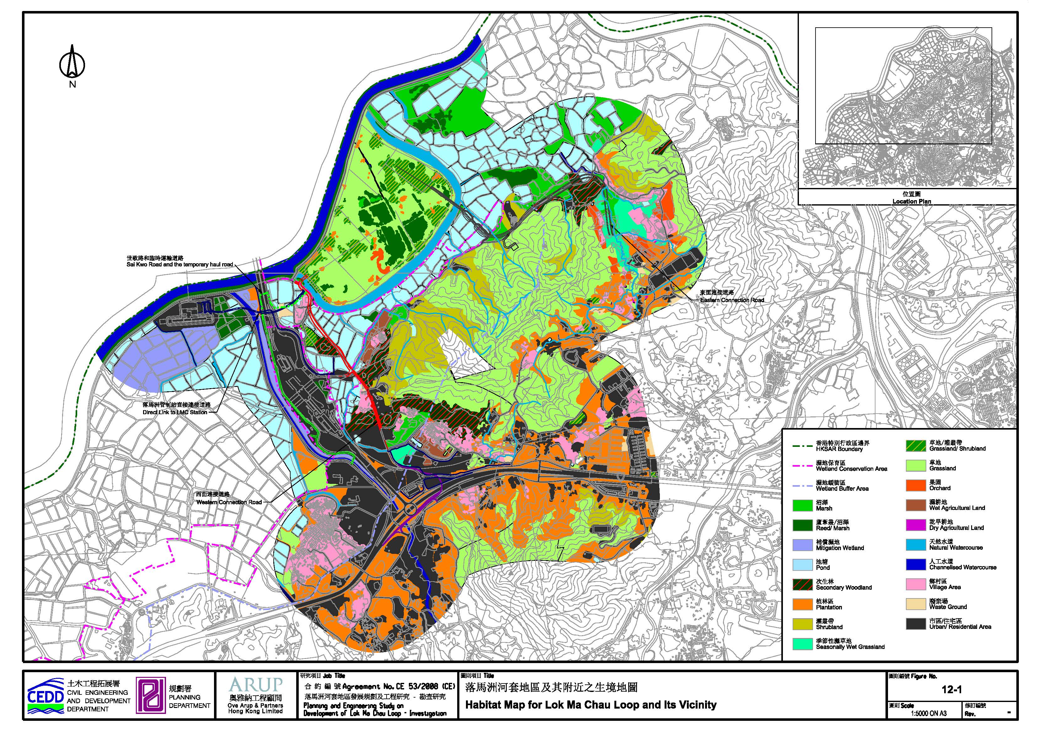
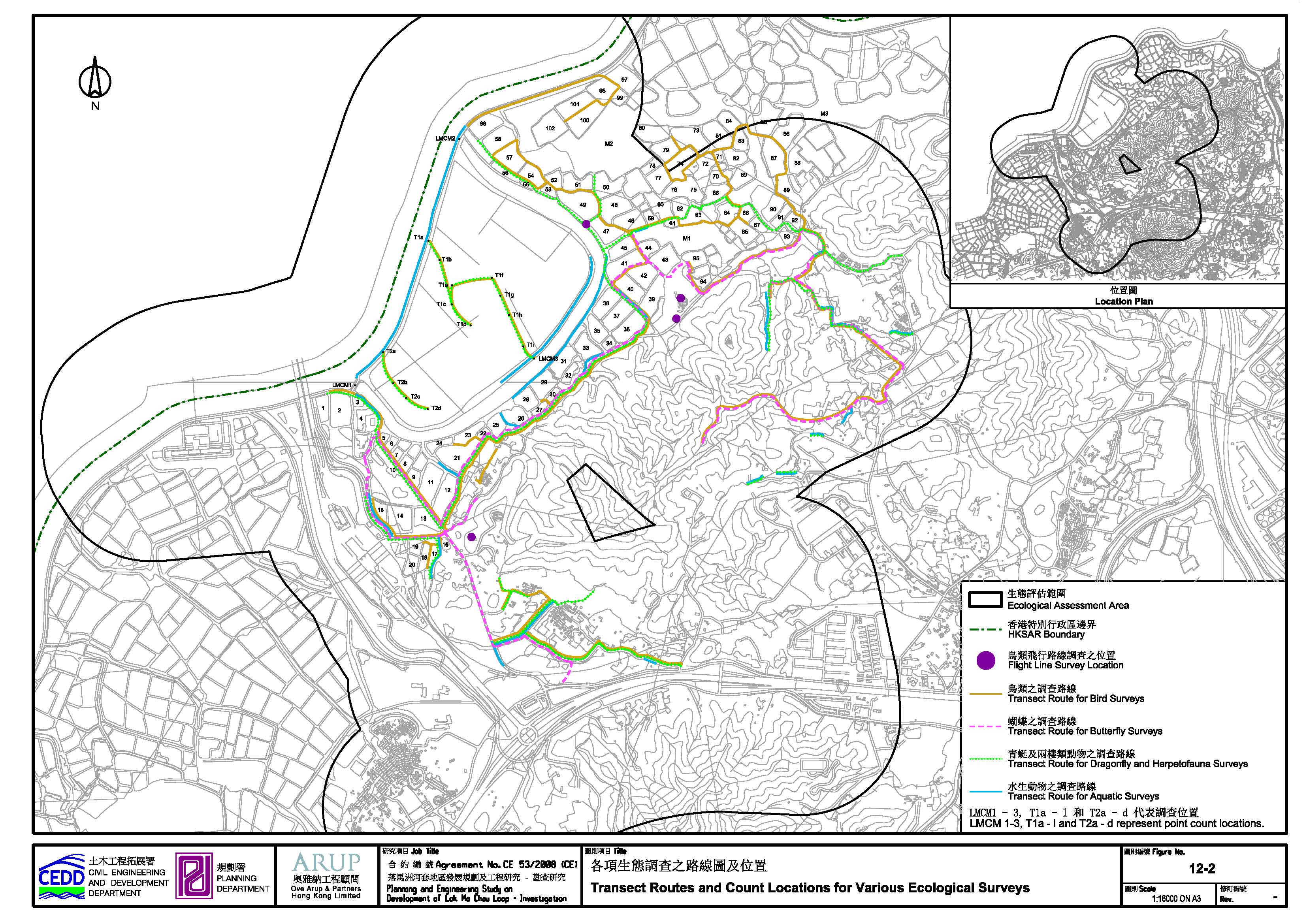
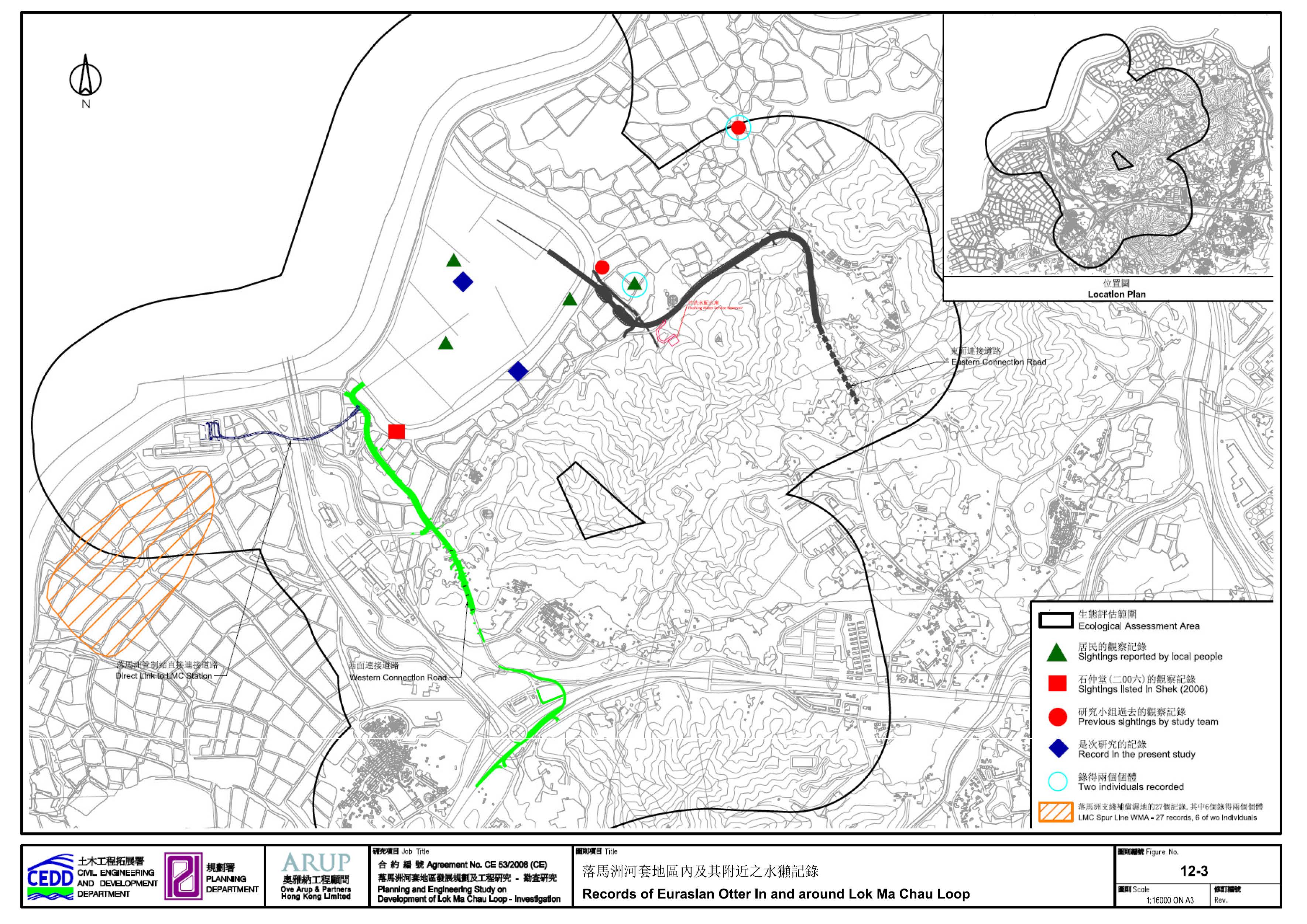
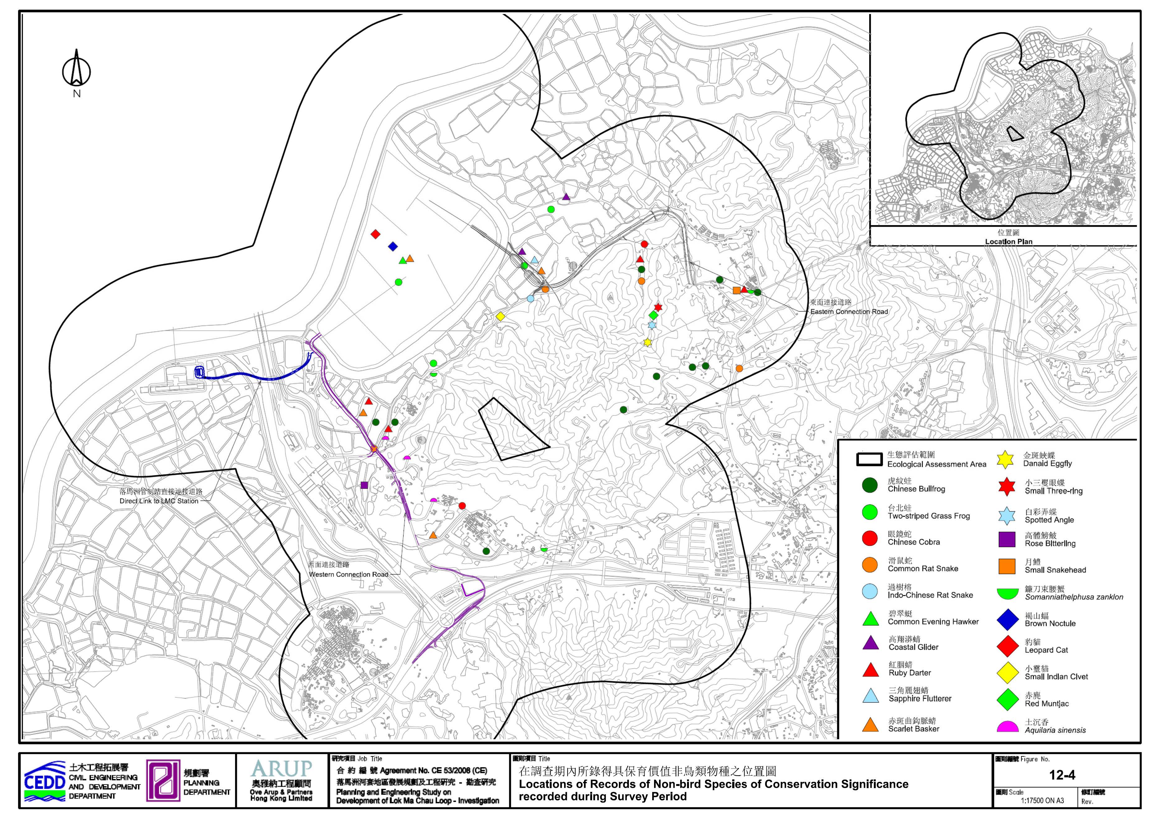
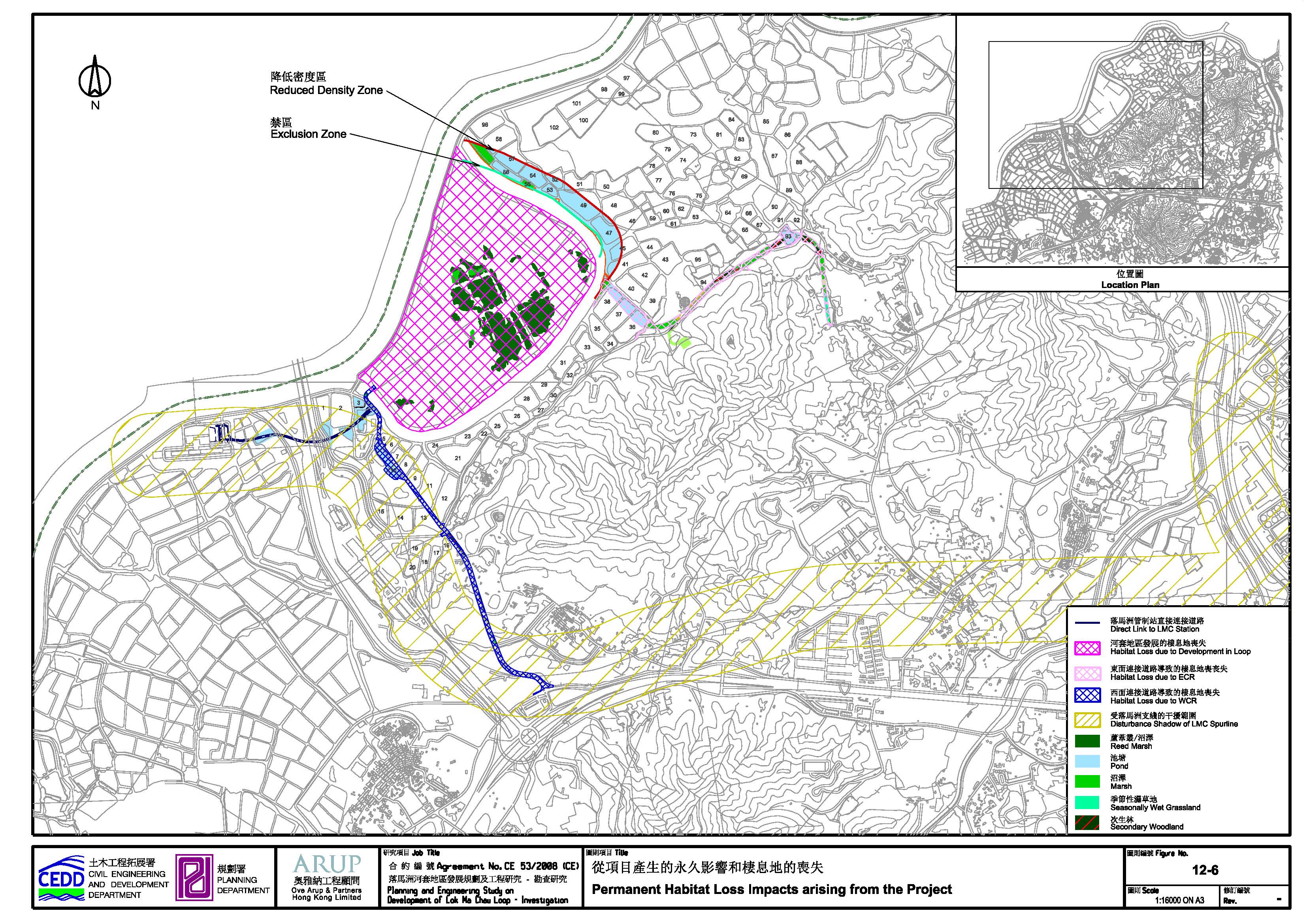
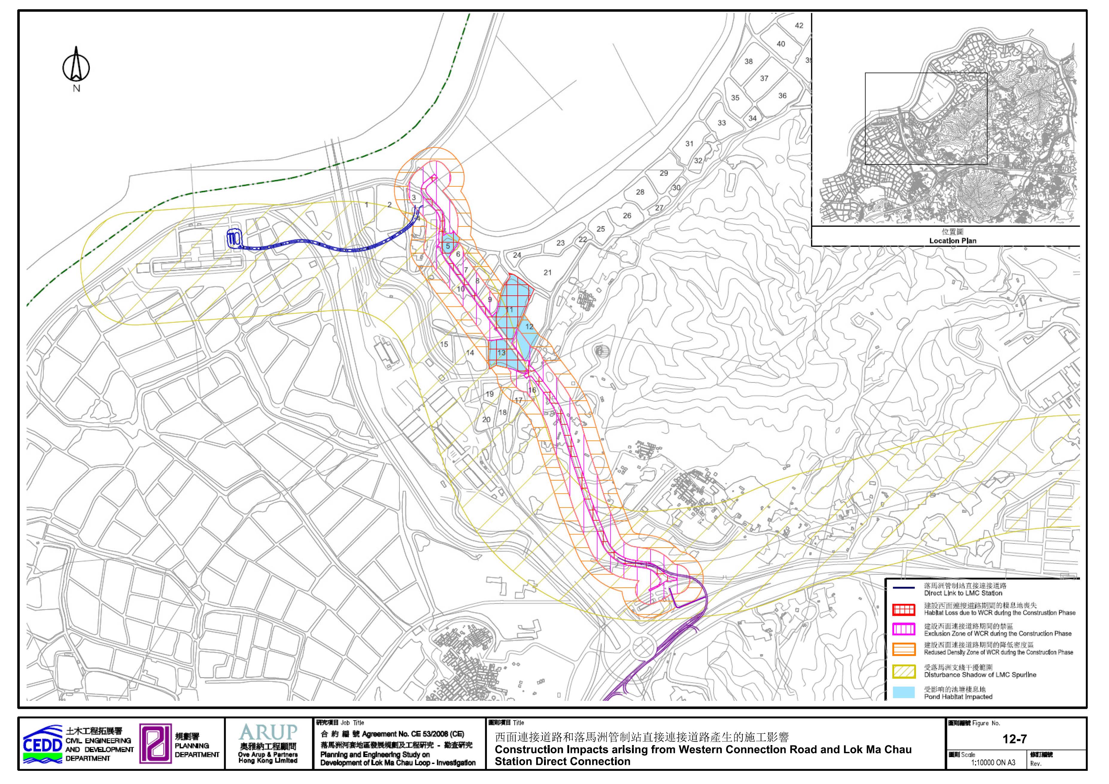
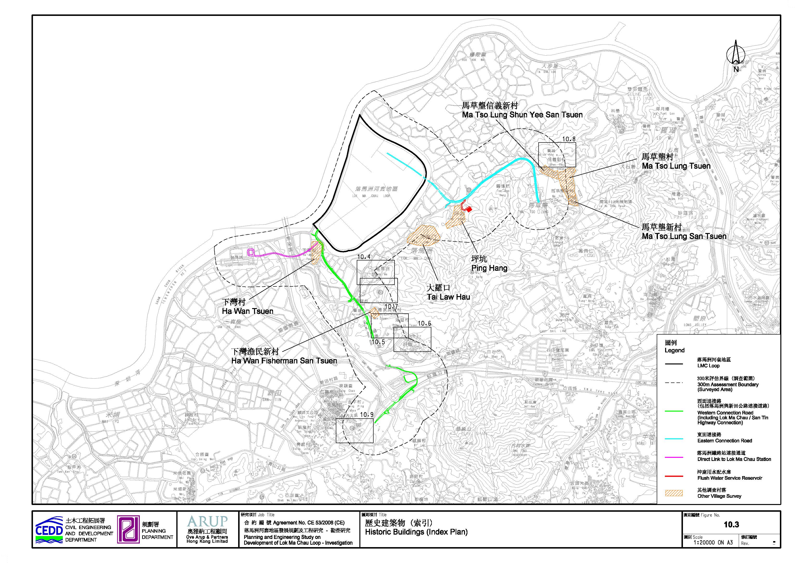
_Page_01.jpg)
_Page_02.jpg)
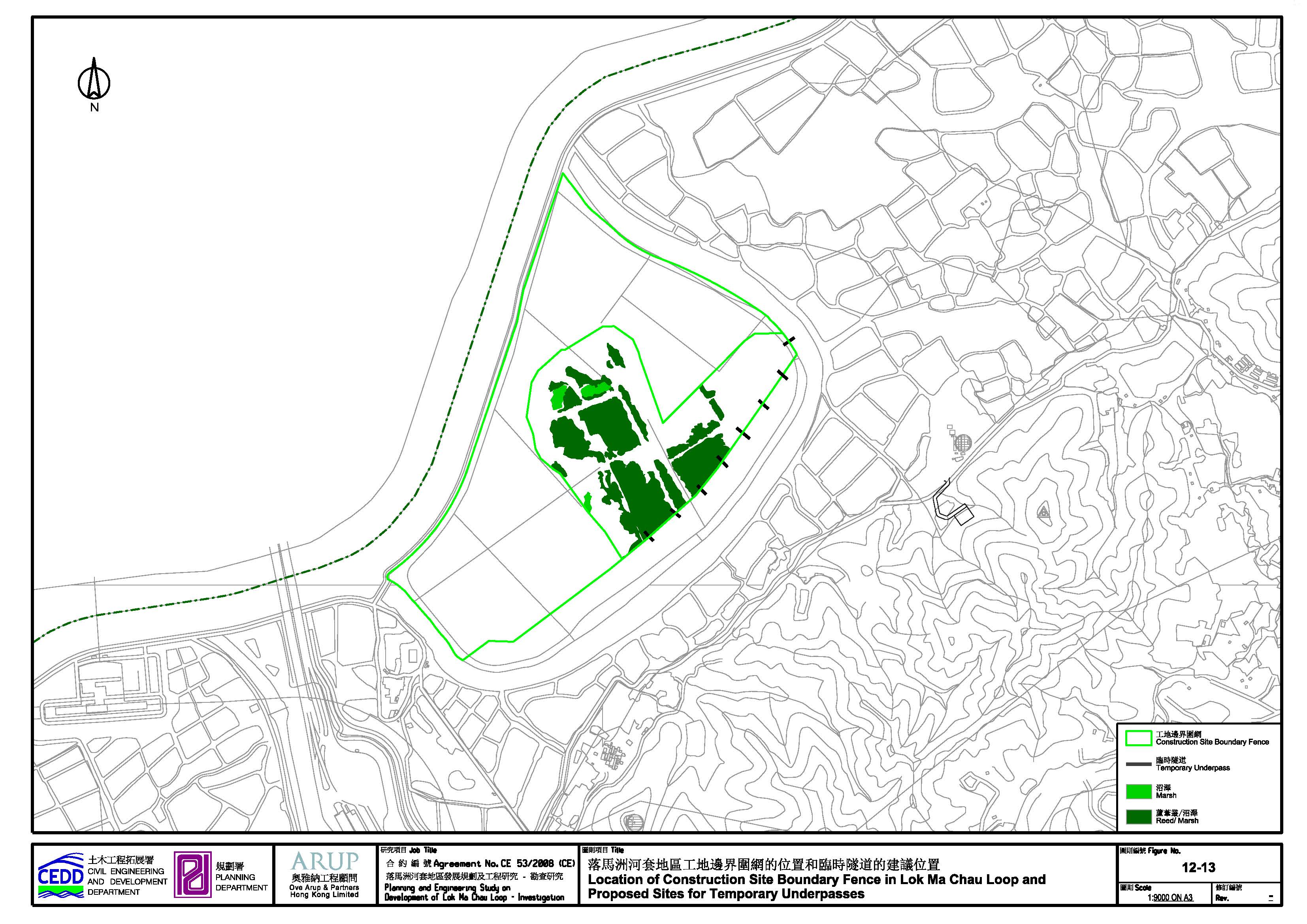
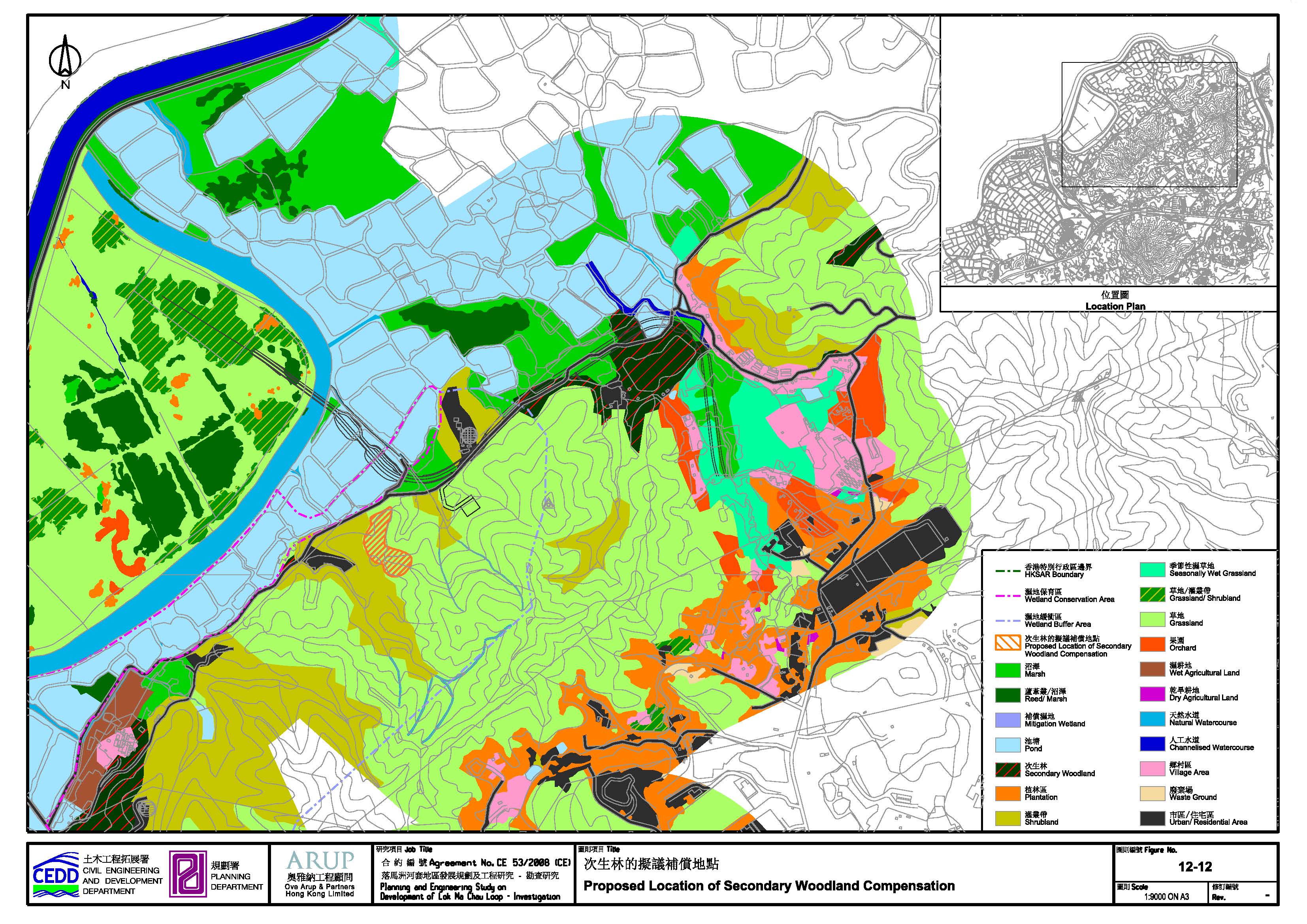
_Page_22.jpg)
_Page_28.jpg)
_Page_21.jpg)
_Page_32.jpg)
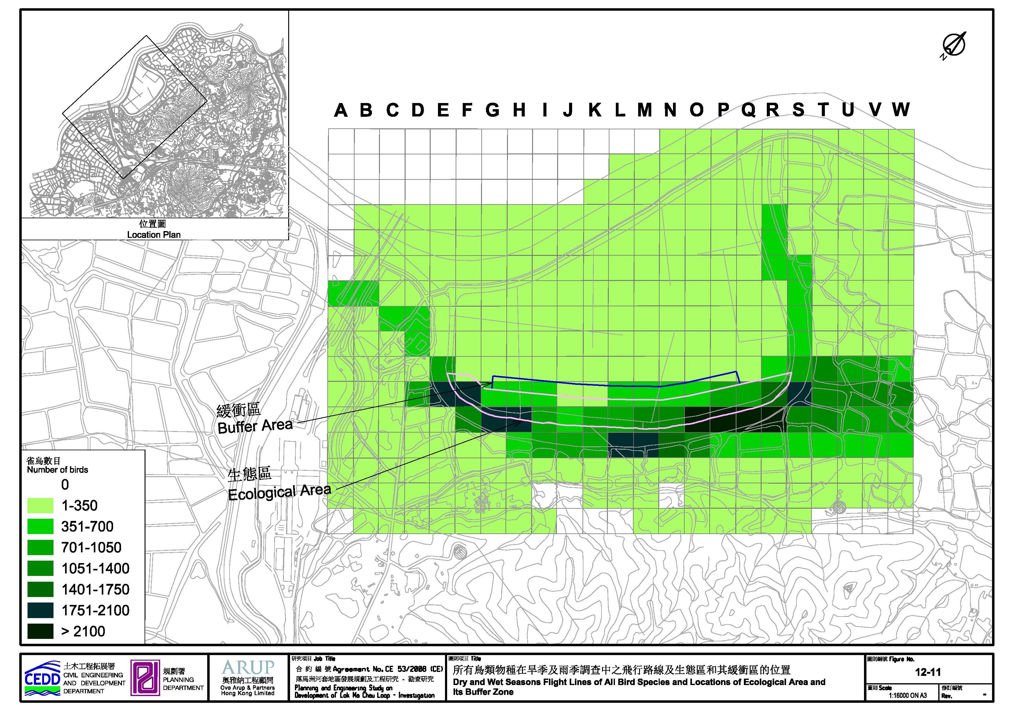
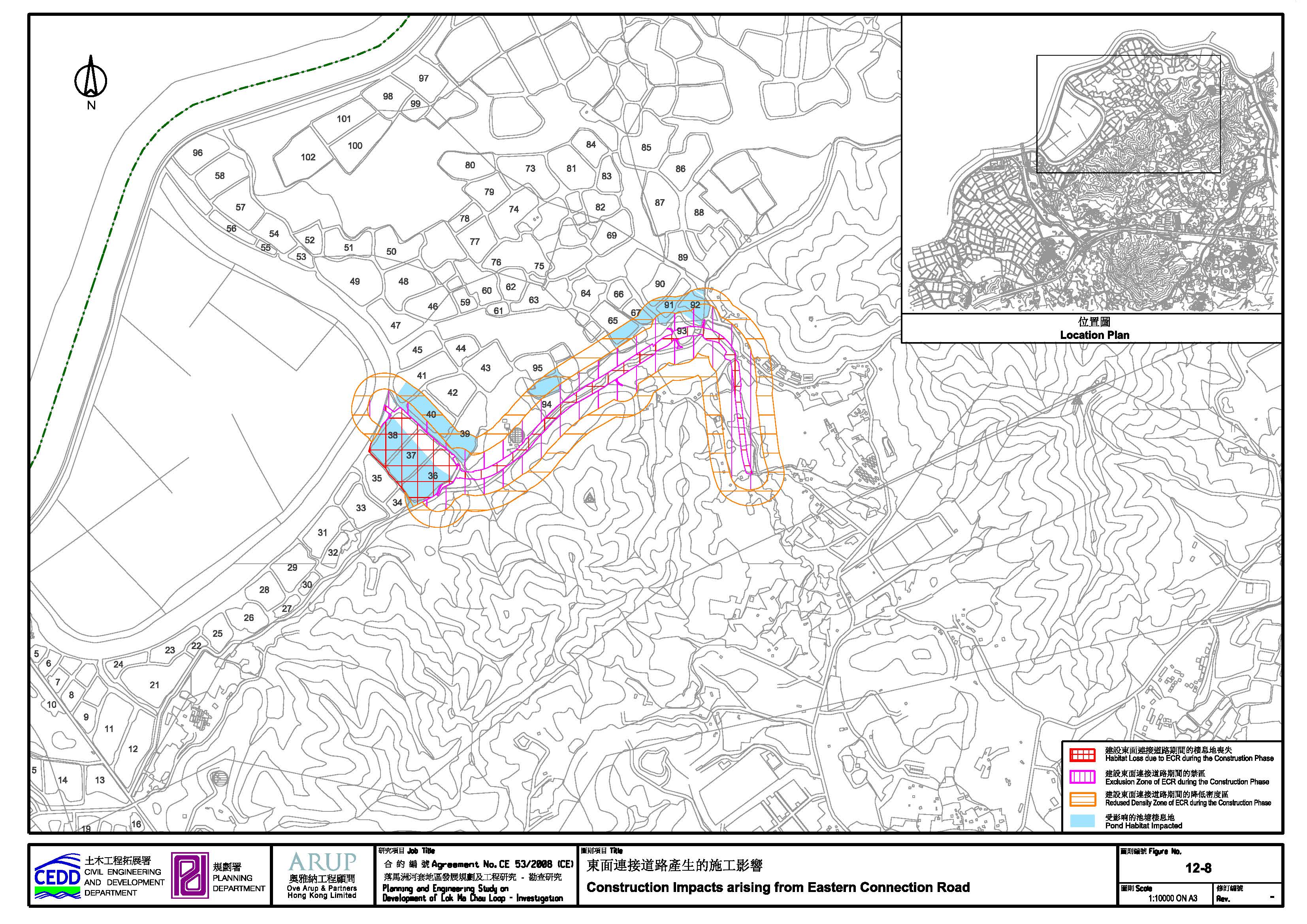
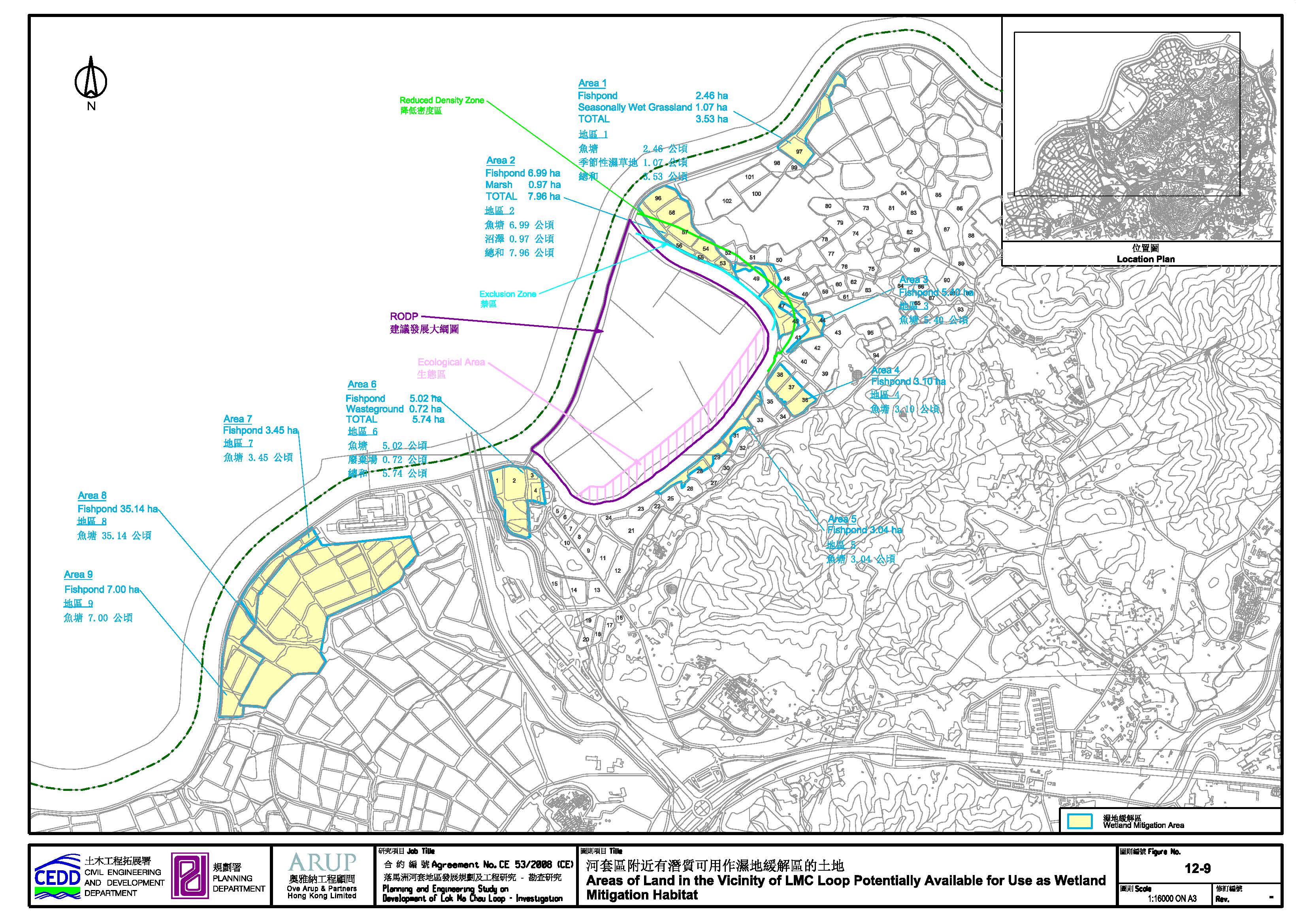
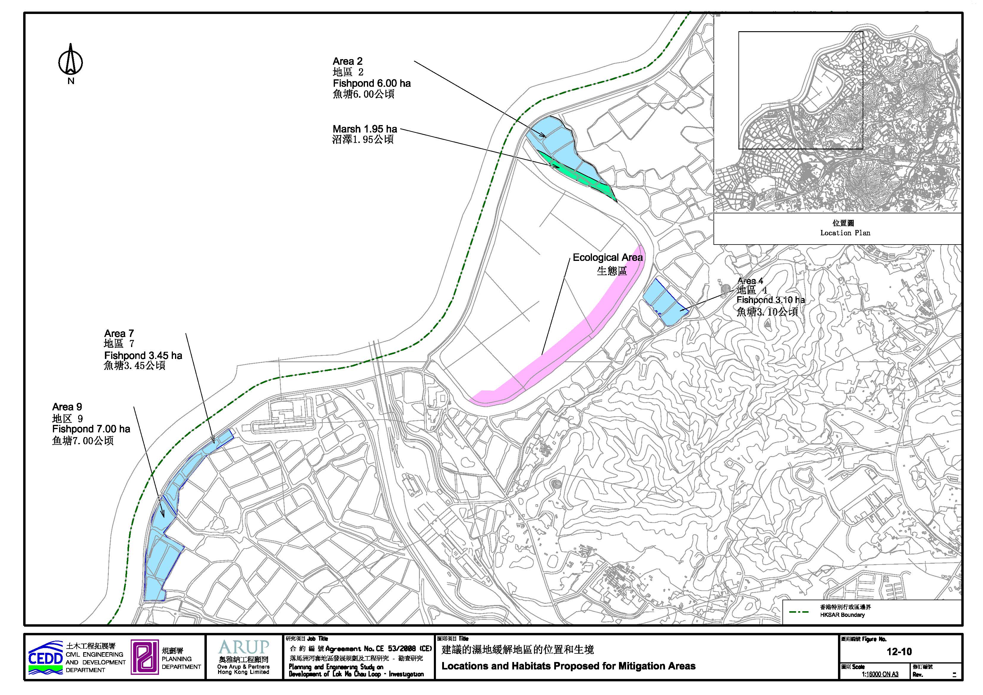