13 Fisheries
Impact Assessment
13.2 Legislation,
Standards and Guidelines
13.6 Identification
and Evaluation of Fisheries Impacts
13.8 Residual
Environmental Impacts and Monitoring and Audit
This section presents the assessment of direct and
indirect fisheries impact for the LMC Loop Project. Baseline information on the
fish ponds within the Assessment Area, assessment methodology, identification
and evaluation of fisheries impacts (if any) arising from the Project and
mitigation measures are included. In general, with the current alignment
selected for external connections, good site practices to minimize dust, water
quality and waste produced, direct and indirect fisheries impacts arising from
the Project is considered to be minor.
The fisheries impact assessment has been conducted in
accordance with the requirement of Annexes 9 and 17 of the TM-EIAO as well as
the requirements set out under Clause 3.4.14 of the EIA Study Brief. The area
for fisheries impact includes all areas within 500m from the boundaries of the
Project, and other water systems of fisheries importance (e.g. Deep Bay) if
potentially impacted during construction or operation of the Project. Special
attention is given to the potential impacts on aquaculture activities and the
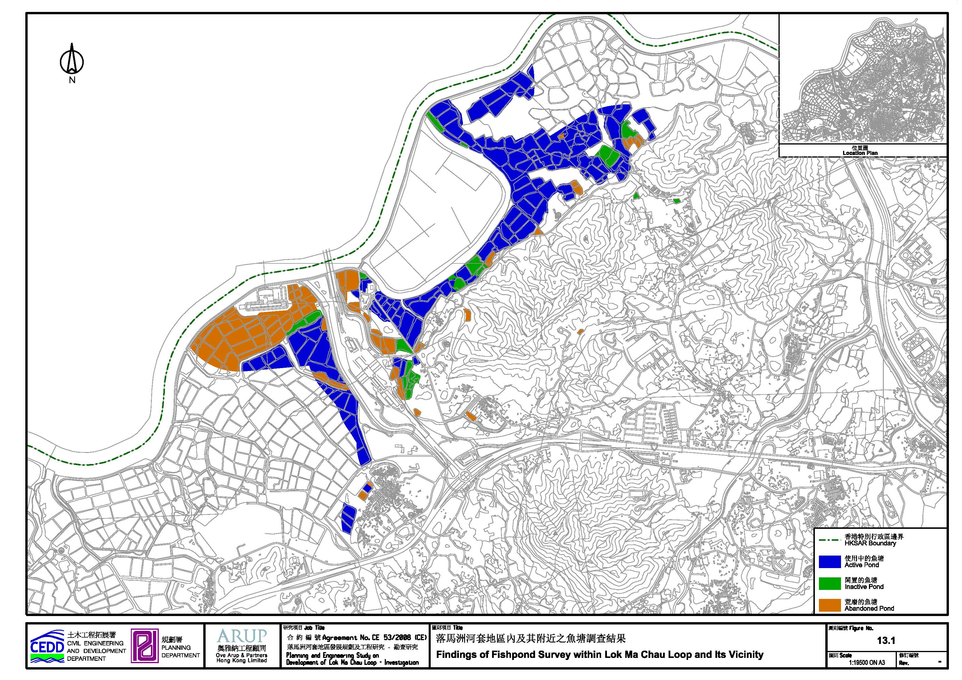
loss of fish ponds. The Assessment Area is illustrated in Figure 13.1.
13.2 Legislation, Standards and Guidelines
The relevant legislations, standards and guidelines
applicable to the present study for the assessment of fisheries impact
assessment:
·
Environmental Impact Assessment Ordinance (EIAO) (CAP.
499), Technical Memorandum on Environmental Impact Assessment Process
(TM-EIAO).
13.2.1
Environmental
Impact Assessment Ordinance (EIAO) (CAP. 499), Technical Memorandum on
Environmental Impact Assessment Process (TM-EIAO)
The general criteria and guidelines for evaluating and
assessing fisheries impacts and considering mitigation measures are documented
in the Annexes 9 and 17 of the TM-EIAO.
Pond fish culture has been practised in the northwestern New Territories for a long period of time.
Traditionally, only primary freshwater fish and several brackish species, such
as Bighead Carp Aristichthys nobilis,
Edible Goldfish Carassius auratus,
Grass Carp Ctenopharyngodon idellus, Mud
Carp Cirrhinus chinensis,
Flathead Mullet and Nile Tilapia Oreochromis niloticus, are farmed. However, in recent years,
certain high-value marine species such as Giant Grouper Epinephelus lanceolatus, Yellowfin
Seabream Acanthopagrus latus and Spotted Scat Scatophagus argus have also been cultured in diluted
seawater by fish farms close to the coast (e.g. at Mai Po).
In order to help local fish farms to develop, AFCD
has introduced new aquaculture species (i.e. Jade Perch Scortum barcoo) to Hong Kong, and also launched
the “Accredited Fish Farm Scheme” (AFFS). Under this scheme, products from
registered fish farms are “accredited” by AFCD, and can be marketed under the
unique brand name of the scheme. The department believes that this scheme can
make local aquaculture products “stand out by branding”.
Several fish farms have started to culture new
species and AFCD has carried out much promotional work; according to the data
extracted from AFCD’s website and AFCD’s annual reports, the production of pond
fish in Hong Kong has stabilised in recent years. Annual pond fish production
and fish pond area in the territory are listed in the Table 13.1.
Table 13.1 Annual pond fish production and fish pond
area
|
Year |
Pond Fish Production (tonne) |
Fish Pond Area (ha) |
Overall Pond Fish Production Rate (kg/ha/year) |
|
1997 |
5000 |
1125 |
4444 |
|
1998 |
4900 |
1110 |
4414 |
|
1999 |
4500 |
1094 |
4113 |
|
2000 |
2817 |
1060 |
2657 |
|
2001 |
2550 |
1059 |
2407 |
|
2002 |
1989 |
1030 |
1931 |
|
2003 |
2114 |
1029 |
2054 |
|
2004 |
1977 |
1026 |
1927 |
|
2005 |
1897 |
1026 |
1849 |
|
2006 |
1943 |
1024 |
1897 |
|
2007 |
1927 |
1160 |
1661 |
|
2008 |
2266 |
1160 |
1953 |
|
2009 |
2105 |
1160 |
1814 |
|
2010 |
2190 |
1109 |
1975 |
|
2011 |
2315 |
1130 |
2049 |
On the other hand, based on the information from
AFCD, local pond fish production accounted for approximately only 4% of local
pond fish consumption in 2011. Most pond fish consumed in the territory are
imported from the Mainland.
There are no capture fisheries known within the
Assessment Area, and no assessment of impact is carried out. Capture fisheries
have not been covered in previous EIA reports for the area such as Improvements
to San Tin Interchange (HyD 2004) or the EIA Report
for Sheung Shui to LMC Spur
Line (KCRC 2002).
Literature review
and internet search have been conducted to assess the baseline status of pond
fish culture activity within the Assessment Area as well as the territory.
Literatures and websites reviewed include:
· AFCD annual reports (1997-2011);
· AFCD website (http://www.afcd.gov.hk/english/fisheries/fish_aqu/fish_
aqu.html);
· HyD. 2004. Improvements to San Tin Interchange. EIA report submitted to the EPD;
· KCRC. 2002. EIA report for Sheung Shui to Lok Ma Chau Spur Line. EIA report submitted to the EPD.
In addition to
desktop survey, site visits were undertaken to investigate actual fisheries
status within the Assessment Area from June to September 2009 and from December
2009 to January 2010. Activities related to fisheries observed during other
field surveys were also recorded. During site visits, local villagers, fish
farmers and pond owners were interviewed. A committee member of the HKNTFCA was
also contacted for further information on local pond fisheries. The actual pond
status was then further updated based on information obtained from AFCD.
Ponds observed
were categorized as follows:
· Active: evidence of commercial aquaculture activities, including commercial fish ponds, fish fry ponds.
· Inactive: no evidence of commercial aquaculture activities, but no major physical constraints to its resumption in the short-term, including ponds with fish present in non-commercial quantities and ponds for casual sport fishing or water sports.
· Abandoned: physical evidence that aquaculture has not taken place for many years (i.e. overgrown) and/or where there are obvious physical constraints to its short-term resumption (i.e. fenced); concreted ornamental ponds and ponds for wetland compensation or wastewater treatment are also included in this category.
13.5.1 LMC Loop
Based
on aerial photos, there were active ponds inside LMC Loop in the past. However,
after the Shenzhen River Regulation Project, these ponds were filled and lost.
Although differential settlement of fill has resulted in the creation of small
pond-like areas, these are not actively managed and are full of emergent
vegetation (and ecologically are marshes). Further, the water quality of these
areas is poor, as excavated mud from the old Shenzhen River was
dumped in this area during the regulation works. These depressions are not active fish
ponds and are not suitable for fish culture.
13.5.2
Hoo Hok Wai, Ma Tso Lung, Tse Koo Hung and Areas covered by Road Alignments
Hoo Hok Wai is a core fish pond area in Hong Kong, with many
active fish ponds. Aquaculture activities such as drying of ponds, reprofiling, harvesting and feeding are routine. Some
ponds, however, are inactive or abandoned; these ponds are usually covered with
dense vegetation and show no sign of commercial aquaculture activity. In areas
to the south of LMC Loop, alongside the current boundary fence road, there is a
mixture of abandoned, inactive and active ponds. Those close to Ha Wan Tsuen or the LMC BCP are mainly not active. Most of these
ponds are not actively managed and some have been abandoned since the
construction of the LMC Spur Line. But certain very small ponds are still
active.
The
ponds in front of the LMC MTR Station are managed to mitigate impacts of the
project on wetland habitat. The fish are not sold to the market. These ponds are
not regarded as abandoned fish ponds. Some ponds on the eastern side of the
Station are managed to treat wastewater, and should also be regarded as
abandoned. Further away from the Station most ponds are actively managed for
aquaculture purposes, but these ponds are far from the Project boundary.
Active
ponds mentioned above usually practise polyculture,
and fish kept in these ponds included Bighead Carp, Common Carp, Edible
Goldfish, Grass Carp, Flathead Mullet, Mud Carp and Nile Tilapia. Unsalable bread
and residues from local food factories were the main feed for these fishes.
These farms follow traditional methods of producing fish. No ponds were found
culturing high-priced species such as Giant Grouper, Scat and Seabream in the Assessment Area.
No pond
was found at Tse Koo Hang. At Ma Tso Lung there are
two non-commercial ponds culturing fish for self-consumption, two abandoned
ponds and one for raising fish fry.
13.5.3
Summary
The
status and area of ponds within the Assessment Area are summarized in the Table 13.2 and Figure 13.1.
Table 13.2 Status
and area (ha) of ponds within the assessment area
|
Pond Category |
Fisheries Status |
Total
Area (ha) |
|
Active |
Commercial fish ponds |
143.04 |
|
Inactive |
Inactive (producing fishes for self-consumption/
not in a commercial manner) |
22.40 |
|
Abandoned |
Fenced/ abandoned/ overgrown/ not for
fisheries purpose |
66.51 |
13.6
Identification and Evaluation of Fisheries Impacts
13.6.1 Construction Phase - Direct Impacts
The following Designated Projects (DPs) have been included in assessing the direct fisheries impact during construction phase:
·
Western
Connection Road (DP2);
·
Direct
Linkage to LMC Station (DP3); and
·
Eastern
Connection Road (DP6).
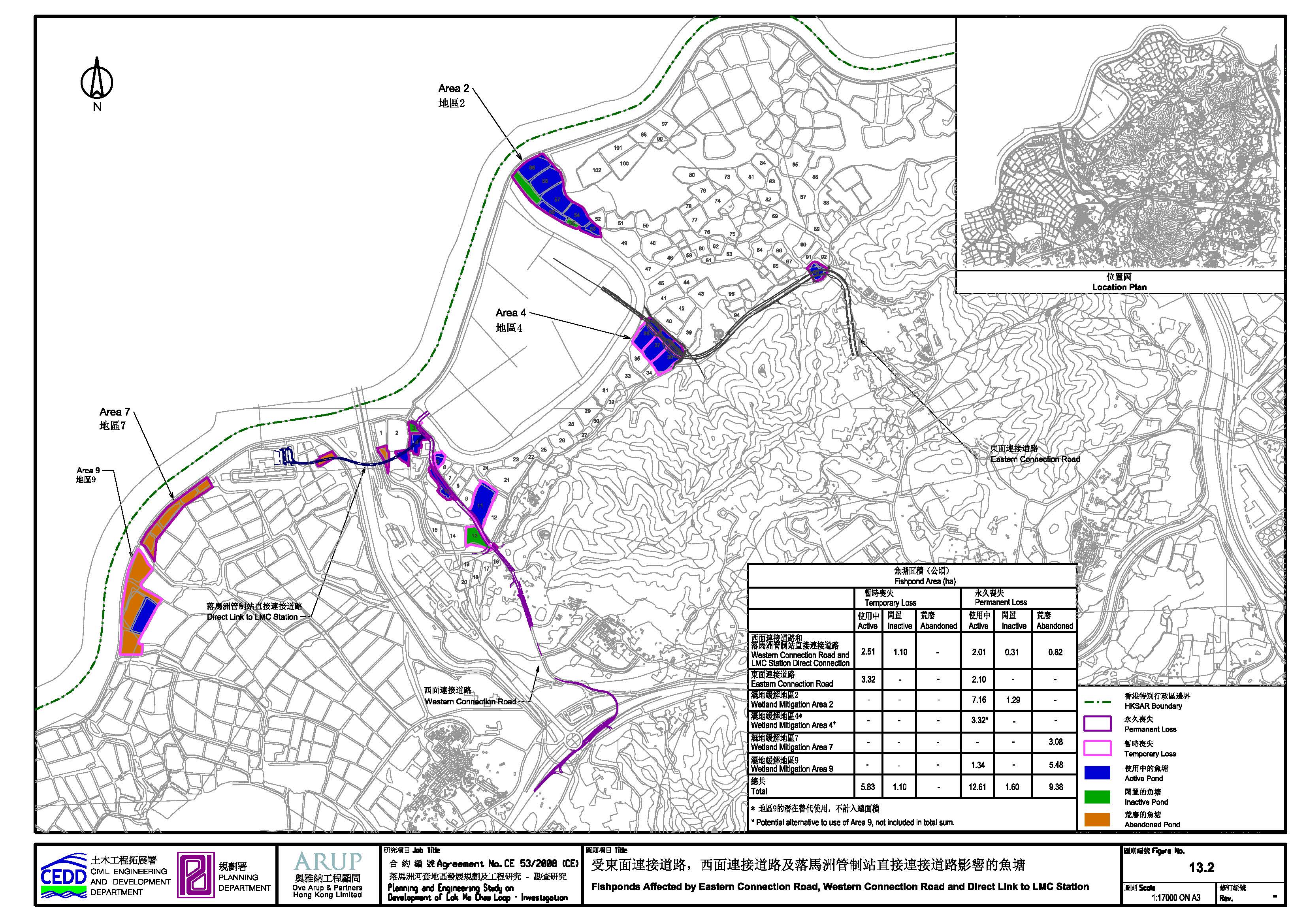
Fish ponds impacted by the Project are illustrated in Figure 13.2.
13.6.1.1 LMC Loop
No direct loss
fisheries impact will result from clearance and development of LMC Loop.
13.6.1.2 Western Connection Road and Direct Link to LMC Station
The Western
Connection Road will utilise alignments of the existing Ha Wan Tsuen Road and Lok Ma Chau Road,
which will be upgraded and widened to meet future traffic volume. The Direct
Link to LMC Station is a new on-viaduct road that provides access to LMC Loop
from LMC Station. Impacts on ponds of these two alignments overlap, as they will
be constructed concurrently. Figure 13.2 illustrates the impacted ponds.
With regard to
the Direct Link, to the west of San Tin Eastern Main Drainage Channel half of
one abandoned pond will be lost permanently (an area of 0.41ha).
Between LMC
Meander and the STEMDC ponds lost permanently include: Pond 3 (0.31ha,
inactive), Pond 4 (0.77ha, active) and the pond immediately to the south of
Pond 1 (0.41ha, abandoned). In addition, the pond immediately south of Pond 2
(0.35ha), which is active, will be lost permanently.
Along the
alignment of the WCR, the active Pond 10 (0.89ha) will be lost permanently.
Finally, the
0.41ha Pond 5, which is active, will be drained during the construction phase,
but reinstated on completion, while active Ponds 11 and inactive Pond 13 (2.10
and 1.10ha respectively) will also be drained only during the construction
phase. Table 13.3 summarises the
pond loss.
13.6.1.3 Eastern Connection Road
The Eastern
Connection Road links the eastern side of LMC Loop with the Kwu
Tung area.
Some reinstatement
of active Ponds 36-38, is possible, and as a result there will be a temporary loss of active
ponds of 3.32ha. There will be permanent loss of 1.36ha of these ponds along
with 0.74ha of active Pond 93. However, since Area 4 (i.e. active Ponds 36-38)
is proposed be designated as wetland mitigation area to address the ecological
impacts arisen from the project, these ponds would be permanently lost. Hence,
the total area of ponds loss as fishpond would be 5.41 ha (active Ponds 36-38
and Pond 93).Two inactive ponds, two abandoned ponds and a fish fry farm are located at Ma Tso Lung. The proposed alignment of the Eastern Connection
Road through Ma Tso Lung, however, is not predicted
to directly impact these ponds or the farm. Thus, no direct fisheries impacts
are predicted.
13.6.2 Construction Phase – Indirect Impacts
The following Designated Projects (DPs) have been included in assessing the indirect fisheries impact during construction phase:
·
Ecological
Area (DP1);
·
Western
Connection Road (DP2);
·
Direct Linkage
to LMC Station (DP3); and
·
Eastern
Connection Road (DP6).
13.6.2.1 Bund
Stability and Water Seepage
There is also the potential for adverse impact on bund stability and water seepage due to construction works in
close proximity.
13.6.2.2 Blockage of
Existing Access
There is the potential for access to fish ponds to be blocked due to
construction works, which may have an impact on management activities and
fisheries production. At the current time, however, the extent of this is
unknown.
13.6.2.3 Dumping
of Construction Waste
Dumping of construction waste or excavated material on
fish ponds other than those already indicated as requiring draining for
construction purposes could cause a direct impact on pond fisheries. If this
activity is not controlled, this impact is considered to be significant.
13.6.2.4 Other
Indirect Impacts
Fish ponds close to the construction site
may be affected by runoff, dust, silt and chemical wastes arising from construction activities.
Untreated runoff and sediment would raise the level
of suspended solids (SS). Elevated SS level may have acute
or chronic effect on fish. In
addition, as the streams and the nearby LMC Meander are sources of water for
active fish ponds, pollutants discharging into these water bodies may also
eventually cause a fisheries impact. Blockage of these water bodies due to poor
construction activities (e.g. disorderly dumping of excavated material) may also
affect the water supply to fish ponds and thus affect
culture activities.
13.6.3 Operational Phase
The following Designated Projects (DPs) have been included in the fisheries impact assessment during operational phase:
·
Ecological
Area (DP1);
·
Western
Connection Road (DP2);
·
Direct
Linkage to LMC Station (DP3); and
·
Eastern
Connection Road (DP6).
Some ponds will be lost permanently. The effect of this has been
evaluated above; this section presents an assessment of other fisheries impacts
likely to appear during the operational phase.
Sewage and runoff from the proposed development could potentially cause
impacts on nearby water bodies. This, in turn, could cause a deterioration of
water quality and affect fish.
The Ecological Area will largely comprise reed marsh, with a small area
of freshwater marsh. This habitat will be similar to inactive or abandoned ponds
and reed and freshwater marshes already in the area. Given the similarity,
there is unlikely to be any discharge different in nature to that existing, and
thus operation of the wetland would not cause any additional adverse impact on
nearby water bodies. Therefore, significant fisheries impact is unlikely to be
caused by the operation of the mitigation wetland.
The development area and proposed alignments may generate surface
runoff, which may contain lubricants, oil or other contaminants that would affect
the water quality of the streams and ponds nearby.
There is concern that existing paths to
active fish ponds may be blocked during the operational phase (i.e. blocked by
proposed connection roads). On the other hand, some ponds will be adjacent to future
connection roads and thus bund stability and water seepage issues may also be
concerns during the operational phase. If these impacts are not mitigated, they
may be significant.
13.6.4 Wetland Mitigation
As mitigation for impacts of wetland loss and disturbance to wetland
habitats elsewhere, both permanent and temporary wetland mitigation is proposed
whereby fish ponds are managed to increase ecological value and attract
required numbers of target species. The management of these ponds will
ultimately be similar to the regime at the wetland mitigation area for the LMC
Spur Line and Station, and thus these ponds will be removed from fish culture
activities.
The first of the areas (Area 2) slated for use as a permanent
mitigation area lies to the northeast of LMC Loop (affected pond numbers are
53-58 and 96). Of these, Ponds 53, 54, 56, 57, 58 and 96 are actively managed,
while the remainder are inactive. The area of active ponds is 7.16ha and the
area of inactive ponds is 1.29ha.
The second
of the proposed areas for permanent mitigation, Area 7, lies adjacent to the
existing wetland mitigation area for the LMC Spur Line and Station. These ponds
are abandoned and have an area of 3.08ha; although in theory they could be
brought back into production, the fact that they lie on government land in a
relatively inaccessible location adjacent to the wetland mitigation area means
that this is highly unlikely. This loss is considered to be of low
significance.
Finally,
Area 9 is proposed. This comprises 7.0ha of land contiguous with both Area 7
and the wetland mitigation area for LMC Spur Line and Station. Most of the
ponds in this area are abandoned, the exception being a single active pond of
1.34ha. 5.48ha of abandoned ponds will also be subject to permanent loss.
A potential
alternative area for permanent mitigation once the Eastern Connection Road is
constructed is Area 4, which comprises Ponds 36-38 near Ngau
Kok Shan, and constitutes 3.32ha. These ponds are
active.
Impacts on
access to adjacent fish ponds are possible, although the locations of the
mitigation areas immediately adjacent to existing roads and to LMC Meander make
this unlikely.
Permanent and
temporary direct fisheries impacts on the Project are summarised in Table 13.3, while an assessment of fisheries
impact is provided in Table 13.4.
Table 13.3 Direct loss of fish ponds arising from the Project.
|
Development aspect |
Temporary Loss |
Permanent Loss |
||||
|
Active |
Inactive |
Abandoned |
Active |
Inactive |
Abandoned |
||
|
WCR/LMC
DC |
2.51- |
1.10- |
- |
2.01 |
0.31 |
0.82 |
|
|
ECR |
3.32- |
- |
- |
2.10 |
|
- |
|
|
WMA
Area 2 |
- |
|
|
7.16 |
1.29 |
- |
|
|
WMA
Area 4* |
- |
|
|
3.32* |
- |
- |
|
|
WMA
Area 7 |
- |
|
|
|
|
3.08 |
|
|
WMA
Area 9 |
- |
|
|
1.34 |
|
5.48 |
|
|
Total |
5.83 |
1.10 |
- |
12.61 |
1.60 |
9.38 |
|
* potential alternative to use of Area 9, not included in
total sum.
WCR/ECR =
Western/Eastern Connection Road; WMA = wetland mitigation area
Table 13.4 Summary
of fisheries impact in absence of mitigation
|
Criteria |
LMC
Loop |
Western
Connection Road and Direct Link to LMC Station |
Eastern
Connection Road |
Wetland
mitigation areas |
|
Nature
of impact |
No
direct impact. Potential
indirect impacts (discharge of sewage/ wastewater, runoff). |
Temporary
and permanent loss of active, inactive and abandoned ponds. Potential
indirect impacts (construction waste dumping, discharge of sewage/
wastewater, runoff, seepage, bund stability, blockage of access roads). |
Temporary
loss of active ponds. Permanent loss of active and inactive ponds. Potential
indirect impacts (construction waste dumping, wastewater, runoff, blockage of
access roads). |
Permanent
loss of both active and abandoned ponds. Potential
impacts on access to adjacent managed ponds. |
|
Size
of affected area |
Nil. |
Temporary
loss: 2.51ha of active and 1.10 ha of inactive pondpond. Permanent
loss: 2.01ha of active pond and 0.31ha of inactive pond and 0.82 of abandoned
pond. |
Temporary
loss: 3.32ha of active pond. Permanent
loss: 2.10ha of active pond. |
For
Area 2 there will be permanent loss of 7.16ha of active ponds and1.29ha of
inactive ponds. Permanent
loss of 3.08ha of abandoned ponds (Area 7) and 1.34ha of active ponds and
5.48ha of abandoned pond (Area 9). Permanent
loss of 3.32ha of active pond (Area 4) will occur should it be chosen. No
temporary losses are anticipated. |
|
Loss
of fisheries resources/ production |
Nil. |
Most
of the affected ponds are not actively managed currently, thus low. |
Only
small area of inactive ponds impacted. |
Given
the dominance of inactive ponds, this does not constitute a significant loss. |
|
Impact
on nursery or spawning grounds |
Nil. |
Nil. |
Nil. |
Nil. |
|
Impact
on fishing activity |
Nil. |
Very
low impact, as only one small pond involved. |
Low. |
Low
impact affecting small number of fish pond operators. |
|
Impact
on aquaculture activity |
Minor. |
Minor
permanent impact. |
Minor |
Minor
permanent impact. |
The total
permanent loss of fish culture production from the Project may affect 23.59ha
(up to 12.61ha of active ponds, up to 1.60ha of inactive ponds and up to 9.38ha
of abandoned ponds) depending on which Wetland Mitigation option is selected.
At a cumulative maximum of slightly more than 2% of the overall fish pond area
in the northwest NT, this is considered to constitute a minor loss to fisheries
production, especially as only 52% of these ponds are currently active.
13.6.4.1 Impacts to
Capture Fisheries
No capture fisheries are present within
the Study Area and as such no impacts are predicted to capture fisheries in the
construction or operational stages of this Project.
13.6.4.2 Impacts to Water Systems of Fisheries Importance
Given the distance from the Study Area,
approximately 10km, it is considered that construction and/or operational
impacts to water systems of fisheries importance (e.g. Deep Bay) are
insignificant.
13.6.4.3 Bio-remediation of Shenzhen River
As
mitigation for odour issues of the Shenzhen River will be required under the
air quality impact assessment, in-situ bio-remediation will be carried out to
improve sediment quality via nitrate injection (no dredging work required). The
major water quality impact of this treatment concerns the potential release of
nitrate-nitrogen, ammonia and heavy metals from sediments into the water. An
in-situ trial test on bio-remediation using calcium nitrate indicated that
downstream nutrient levels of TKN, ammonia nitrogen, nitrate, nitrite and total
nitrogen will increase slightly under low-flow conditions, but will be highly
diluted by natural tidal surge. This slight low-flow increase in nutrient
levels in what is already a eutrophic system is
predicted to have an insignificant impact in downstream areas, including Mai Po
Inner Deep Bay Ramsar Site and the oyster farms some
10km south west of the LMC Loop.
13.6.5 Cumulative Impact
Since this project is not predicted to cause significant fisheries impact
(i.e. no large area of active fish pond would be affected permanently), the
potential for significant cumulative impacts is limited. The NENT NDA PES is
not currently predicted to cause significant fisheries impact except in respect
of fish fry ponds near Ho Sheung Heung. However, no
fish fry ponds are predicted to be impacted by the current Project.
The Closed Area study included HHW as part of its study area, but no
development was proposed for this area, and thus no impacts were predicted.
Work on the preparation of an OZP for HHW is now under way. The land use
zonings ultimately adopted for HHW may have potential impact on fisheries, but
it is currently unknown what these will be. Ongoing construction of a secondary
boundary fence will bring negligible impacts on fisheries.
13.7.1 Loss of Pond Areas
Permanent loss of
a small
area of active, inactive and abandoned ponds is
considered to be a minor impact, in view of the small contribution to the total
fish pond area in Hong Kong. It is considered that no mitigation is required
for this loss.
13.7.2 Dumping of Construction Waste
Illegal
dumping of waste and excavated material will be properly managed (see Chapter 7), and thus such impact is not
predicted to occur.
13.7.3
Bund Stability and
Water Seepage
During the construction stage, a layer of
permanent sheet pile wall will be erected along the site boundary adjacent to
fish ponds after commencement of site works. The sheet pile wall will be
constructed by silent piling method (Press-in method) which induces minimal
vibration. Therefore the stability of the fish pond bund will not be influenced
by the construction of the sheet pile wall, subsequent construction works and
the loading from the road during operational stage. In addition, the sheet pile
wall will have grouting or a grout curtain to avoid water seepage from the fish
pond to the excavation area. With these measures, significant impacts are not anticipated.
Prior to
the operational phase, affected ponds will be reinstated as far as practicable
after completion of construction works.
13.7.4
Blockage of Access
Roads to Fish Ponds
Temporary traffic arrangements will be
instigated to maintain or provide alternative access to fish ponds during
construction phase. Detailed arrangement cannot be provided at this stage, but
the project proponent will be responsible for drawing up such an arrangement
with the contractor as and when necessary throughout the construction period.
Subsequently, access to the fish ponds will not be blocked in the operational
phase.
13.7.5
Other Indirect Impacts
Standard mitigation measures to control site
runoff and other pollutants caused by construction activities and good site
practices will be implemented during the construction phase of the Project.
Excavated material and other inert construction wastes produced will be
transferred to proper recipients (i.e. landfill) (see Waste Management
Section). Sewage from the proposed development will be dealt with via a sewerage
system and will not be discharged directly to surrounding water bodies. With
these measures, indirect impacts on fisheries due to construction activities
will be insignificant (for details of measures protecting nearby water bodies
including fish ponds please see Water Quality Impact Assessment).
13.7.6
Wetland Mitigation Impacts
Operation of the wetland mitigation areas
required to compensate for direct and indirect impacts on wetland areas arising
from the project result in the loss of both active and inactive ponds. However,
this is considered to be a minor and insignificant impact in view of the small
contribution to the total fish pond area in Hong Kong. It is considered that no
mitigation is required for this loss.
13.7.7 Good Site Practice
13.7.7.1 Dust Minimization
During all excavation works, good site practice should be adopted to
minimize impacts on fisheries. The below site practices should be adopted
during this time.
·
Any
excavated or stockpile of dusty material should be covered entirely by
impervious sheeting or sprayed with water to maintain the entire surface wet
and then removed or backfilled or reinstated where practicable within 24 hours
of the excavation or unloading;
·
Any dusty
materials remaining after a stockpile is removed should be wetted with water
and cleared from the surface of roads;
·
Exposed
earth should be properly treated by compaction, turfing,
hydroseeding, vegetation planting or sealing with
latex, vinyl, bitumen, shortcrete or other suitable
surface stabiliser within six months after the last
construction activity on the construction site or part of the construction site
where the exposed earth lies;
·
Excavation
profiles must be properly designed and executed with attention to the relevant
requirements for environment, health and safety;
·
In case
the soil to be excavated is situated beneath the groundwater table, it may be
necessary to lower the groundwater table by installing well points or similar
means;
·
Supply of
suitable clean backfill material after excavation, if required;
·
Vehicles
containing any excavated materials should be suitably covered to limit potential
dust emissions or contaminated run-off, and truck bodies and tailgates should
be sealed to prevent any discharge during transport or during wet season;
·
Speed
control for the trucks carrying contaminated materials should be enforced; and
·
Vehicle wheel
washing facilities at the site’s exit points should be established and used.
13.7.8 Contingency Plan
The contractor
should prepare an emergency contingency plan for actions to be taken if significant impacts, such as accidental spillage
of chemicals, water seepage from fish ponds, damaged/ destabilized pond bunds,
pond water contamination by site runoff, on fish ponds occur. The contractor should submit the emergency contingency plan dealing
with, but not limited to, the aforementioned potential impacts to the engineer
for review, comment and approval. The fish pond
operators will also be consulted for the details of the contingency plan, which
will also be submitted to AFCD for review and comment. The plan should include, but not limited to, the following:
·
Potential
emergency situations;
·
Chemicals
or hazardous materials used on-site (and their location);
·
Emergency
response team;
·
Emergency
response procedures;
·
List of
emergency telephone hotlines;
·
Locations
and types of emergency response equipment;
·
Training
plan and testing for effectiveness.
During the operational phase, it is also
suggested that similar plan should be in place to deal with any accidental
spillage event.
13.8 Residual Environmental Impacts and Monitoring and Audit
With the
above measures and measures for mitigating water quality impacts and managing
waste, no residual impact is anticipated.
With the monitoring and audit for water
quality, specific programme for fisheries is not deemed necessary.
Since the pond areas to be lost do not account for a
significant proportion of the total fish pond area in Hong Kong, the fisheries
impact is considered to be low significance. Indirect
impacts arising from construction activities and operation of the proposed
development would be properly mitigated through standard practices and thus no
significant fisheries impact is anticipated. Overall, no unacceptable fisheries
impact is predicted from this project.