Contents
2 Brief
Description of the Project
2.1 General
Description of the Project Environment
2.2 General Description of the Project
2.3 Need
and Benefits of the Project
3 Consideration of Alternatives
3.2 Outline Development Plan and Layout
Options
3.3 Feasible Alternative Infrastructure Options
4 Summary
of Main Findings of the Assessment
4.5 Sewerage
and Sewage Treatment
4.12 Fisheries
Impact Assessment
4.15 Environmental
Monitoring and Audit
Figure 2.1a Layout Plan (Overall) and
Designated Projects
Figure 2.1b Revised Preliminary Layout
Plan
Figure 2.1c Off-site Works Area – Wetland
Compensation (Fishpond/Reedbed)
Figure 2.1d The
Project and Temporary Works Area
Appendix 3-1 Development Options
Appendix 3-2a Road Alignment Option for Western Connection Road
Appendix 3-2b Road Alignment Option for Eastern Connection Road
Appendix 3-2c Road Alignment Option for Direct Link to MTR LMC Station
Before the training of Shenzhen River, the Lok Ma Chau Loop (LMC Loop) was within the administrative boundary of Shenzhen Municipal Government. It now lies within the administrative boundary of the Hong Kong Special Administrative Region (HKSAR).
In the Chief Executive’s 2007 Policy Address, the development at LMC Loop is one of the ten major infrastructure projects for economic growth of the Hong Kong Special Administrative Region (HKSAR). The HKSAR Government would work with the Shenzhen authorities to tap the land resources of the LMC Loop to meet future development needs and consolidate the strategic position of both cities in the Pan-Pearl River Delta region.
Subsequent to the signing of the “Co-operation Agreement on Recently Initiated Major Infrastructural Projects” at the Hong Kong-Shenzhen Co-operation Meeting on 18.12.2007, a “Hong Kong-Shenzhen Joint Task Force on Boundary District Development” (Joint Task Force), co-chaired by the Secretary for Development of the HKSAR Government and the Executive Vice Mayor of Shenzhen Municipal Government, was set up to coordinate and steer research and studies in relation to planning and development of land in the boundary district, including, inter alia, the LMC Loop.
At its first meeting on 10.3.2008, the Joint Task Force agreed that Hong Kong and Shenzhen would conduct a joint study on planning, environmental, and engineering feasibility for the development of the LMC Loop. Public engagement exercise on the possible future land uses of the LMC Loop was then carried out concurrently in Hong Kong and Shenzhen between June and July 2008. In the meanwhile, the Shenzhen Municipal Environmental Protection Bureau (SZMEPB) had appointed consultants to carry out terrestrial ecological investigation, marine/aquatic ecological baseline study and soil contamination testing works for the LMC Loop in 2008. Among the proposed land uses, higher education, research and development of new high technology and cultural and creative industries received wide support from both sides.
At the Hong Kong-Shenzhen Cooperation
Meeting on 13.11.2008, a co-operation agreement was signed on the undertaking
of a comprehensive study for the development of the LMC Loop. The meeting initially considered that higher
education might be developed as the leading land use in the LMC Loop,
complemented with some elements of high-tech research and development (R&D)
facilities as well as cultural and creative (C&C) industries. This
would provide impetus for human resources development in the South China region
and enhance the competitiveness of the Pearl River Delta (PRD), as well as
benefit the long-term economic development of the two cities. In 2009, the “Planning and
Engineering Study on the Development of Lok Ma Chau Loop – Investigation” (P&E Study) was jointly
commissioned by the Hong Kong Planning Department (PlanD)
and Civil Engineering and Development Department (CEDD) with participation from
Shenzhen. The findings
of the baseline survey by SZMEPB were provided for reference under the P&E
Study. In parallel, a separate study for the adjoining area on Shenzhen side was
commissioned by the Shenzhen government with participation from Hong Kong.
Stage 1 public engagement was conducted in Hong
Kong and Shenzhen between November 2010 and January 2011 to seek public views
on the Preliminary Outline Development Plan (PODP) (Appendix 1-1) for the LMC Loop. Based
on the public views on the PODP and engineering assessment, the draft
Recommended Outline Development Plan (RODP) (Appendix 1-1) was formulated and put
forward to collect public views in the Stage 2 public engagement between May
and July 2012. A Preliminary Layout Plan was then developed taking into account
the public views, planning and engineering considerations (Details are discussed
in Section 2).
The Project also comprises the developments and infrastructure within the LMC Loop and the supporting infrastructure in the adjacent area in Hong Kong outside the LMC Loop. The tentative construction of the Project was scheduled to commence in phases in late 2013 / early 2014 so as to make land progressively available for development from 2016 to 2018.
The Project (Development of LMC
Loop) is a designated project (DP)
under Item 1 Schedule 3 of EIAO - Engineering feasibility study of urban
development projects with a study area covering more than 20 ha or involving a
total population of more than 100,000.
Individual project
components were identified in light of the need for various stages in the implementation programme
(see Section 2.5.3). In addition,
the following project components associated with the LMC Loop Development also
fall under various Schedule 2 DP categories:
l DP1: Ecological Area, which
has a secondary function as a flood storage pond and the area is larger than 10
ha in size, under I.2 in Schedule 2 of Part 1;
l DP2: Western Connection
Road (including LMC Road Connection to Fanling / San
Tin Highway), which involves widening of existing roads partly in a conservation
area, under Q.1 in Schedule 2 of Part 1;
l DP3: Direct Link to Mass
Transit Railway (MTR) LMC Station, which includes a viaduct more than 100m in
length between abutments and partly in a conservation area, under A.8 and Q.1
in Schedule 2 of Part 1;
l DP4: Drainage System under
Internal Transport Networks, which discharge points are less than 300m from a
conservation area, under I.1 in Schedule 2 of Part 1;
l DP5: Sewage Treatment
Works, which has an installed capacity more than 5,000m3 per day, is located
less than 200m from the planned educational institution and involves an
activity for the reuse of treated sewage effluent, under F.2 and F.4 in
Schedule 2 of Part 1;
l DP6: Eastern Connection
Road, which is a new access road partly in a conservation area with an
underpass section more than 100m and involve diversion works which discharges
into an area which is less than 300m from the conservation area, under A.9, I.1
and Q.1 in Schedule 2 of Part 1; and
l DP7: Flushing Water Service
Reservoir, which involves an activity for the reuse of treated sewage effluent,
under F.4 in Schedule 2 of Part 1.
For the avoidance of doubt, the upgrading of Shek
Wu Hui Sewage Treatment Works (SWHSTW) in connection with DP5’s compliance with
“No Net Increase in Pollution Load requirement in Deep Bay” policy is also a
Designated Project under F.1 Schedule 2 of Part 1. The EIA for this DP will be
conducted under the North East New Territories New Development Areas Planning
and Engineering Study (NENT NDAs Study) but not under this study.
An application for an EIA Study Brief was made to
the Environmental Protection Department (EPD) and the EIA Study Brief No.
ESB-201/2008 for the Project had been issued under the Environmental Impact
Assessment Ordinance (EIAO) before the start of the P&E Study. During the
course of the Study, it was found needed to adjust the Study Area due to the need to
accommodate the alignment of the proposed transport infrastructure falling
outside the original Study Area in EIA Study Brief ESB-201/2008. As such, a
revised project profile (No. PP-455/2011) was submitted to EPD on 3 November
2011 and a new Study Brief (No. ESB-238/2011) under section 5(1)(a) of the EIAO was issued on 12 December 2011. The resulting Study Area comprising Area A,
Area B and Added Area B is as shown in Figure 1.1.
In accordance with the Project Proponent’s clarification ref:
NTNTPF2/6/44(E) dated 12 September 2012, the project scope shall comprise:
(a)
both land use developments / proposals and associated infrastructure
that are considered and proposed in LMC Loop (Area A), for preparation of the
Recommended Outline Development Plan (RODP); and
(b)
only associated infrastructure (e.g. roads, service
reservoir, etc) for supporting the development of the LMC Loop in Area B
(including Added Area B) that have been considered and proposed under the
Project.
2.1
General Description of the Project Environment
The LMC
Loop is located near several major cross-boundary transport nodes including the
Lok Ma Chau (LMC) Boundary Control Point (BCP), the
MTR LMC Station of the LMC Spur Line and the San Tin Interchange. To the north across the Shenzhen River is the
Huanggang Port in Shenzhen and Futian
Commercial District Zone. During Shenzhen River training works,
the LMC Loop was used as a dumping ground for sediments extracted from the
older riverbed, some of which were contaminated.
Outside LMC Loop within Hong Kong side is currently a tranquil rural
area which is characterised by essentially rural land uses including arable
farming and fish ponds. To the southwest is the Mai Po Nature Reserve and
to the northeast is Hoo Hok
Wai, comprising mainly fish ponds with high ecological value. Furthermore, a large part of the
Project lies within the Inner Deep Bay and Shenzhen River Important Bird Area.
A few village settlements, including LMC Tsuen,
Pun Uk Tsuen,
Chau Tau Tsuen, Ha Wan Fisherman San Tsuen, Shuen Yee San Tsuen and Ma Tso Lung Tsuen lie away from the Project and are mainly surrounded
by arable lands and fish ponds.
The area around the San Tin Interchange has been occupied for uses
closely related to the cross-boundary activities. These include open car parks
and open storage compounds for the cross-boundary commuters and goods, as well
as a public transport interchange for cross-boundary shuttle bus services.
Further away from the highways, these areas are characterised by rural land
uses with arable farming and land covered by trees.
The Project falls within the Deep Bay Water Control Zone according to
the Water Pollution Control Ordinance.
There is no public sewerage system in the vicinity of proposed
development site except for the sewage treatment works within MTR LMC Station,
which is designed for terminus use only. Existing domestic wastewater generated
by villages nearby is likely discharged directly to nearby streams or collected
by individual soak away and septic tanks systems.
2.2
General Description of the
Project
The project
is to develop the LMC Loop with higher education as the leading land use,
complemented by high-tech R&D and C&C industries. According to the development
parameters, the estimated total number of students and employees is
approximately 53,000, based on a maximum total Gross Floor Area (GFA) of
1,200,000m2 and an overall plot ratio of 1.37.
The Project
comprises the development and infrastructure within LMC Loop (about 87.7ha) according to the Revised Preliminary Layout Plan (PLP) and
associated supporting infrastructure / works within and outside the LMC Loop (Figure 2.1a to 2.1d). The
proposed key infrastructure include roads within the Loop, external connection
roads such as Western Connection Road, Eastern Connection Road and the Direct
Link to MTR LMC Station, sewage treatment works, flushing water service
reservoir, district cooling systems (provisional), fire station cum ambulance depot, electricity
substations, drainage and sewage systems, water supply network and public
utilities. Mitigation measures such as offsite compensation of wetland area and
bioremediation works at Shenzhen River are also proposed along with this EIA
Study.
Other
project components that are related to the implementation of Development of LMC
Loop but under separate EIA studies includes Kwu Tung
North Fresh Water Service Reservoir and upgrading of Shek
Wu Hui Sewage Treatment Works for
off-site compensation to comply with the “No net increase in pollution load
requirement in Deep Bay”. The EIA of
these project components were included in the NENT NDAs Study.
2.3 Need and Benefits of the Project
Need and
Benefits of the Project
The Project
is required to meet the future needs for the development of Hong Kong and
Shenzhen and to consolidate the strategic position of the two cities in the
region. The unique history and strategic location of the LMC Loop makes it the ideal project for
Hong Kong and Shenzhen to showcase the cooperation of both cities in jointly
developing this piece of land into a knowledge and
technology exchange zone that meets the future development aspirations of the Hong Kong and Pearl River Delta.
With a view to developing a sustainable,
environmentally-friendly, energy efficient and people-orientated community, the project vision is to develop the LMC Loop
as a hub for cross boundary human resources development within a sustainable
Knowledge and Technology Exchange Zone (KTEZ). This would provide impetus for human resources development in South
China, enhance the competitiveness of the Pearl River Delta, and benefit the
long-term economic growth of the two cities as well as the broader Pan River
Delta region.
The Project
also aligns with the Framework Agreement on Hong Kong/Guangdong Co-operation
(the Framework Agreement) which was signed between the two governments in
2010. One of the major initiatives of
the Framework Agreement is to promote collaborative development in Hong Kong
and the PRD cities to form a world-class metropolitan region. To achieve this goal, Hong Kong and Guangdong
have put forward a number of specific policies and measures. One of the key collaborative developments
under the Framework Agreement is to develop the LMC Loop with higher education
as the leading land use, complemented by high-tech R&D and C&C
industries under the principle of “co-study, co-development and mutual benefit”. Through closer co-operation, a world class
metropolis comparable with Greater New York and Greater London would be
developed as revealed in the second Hong Kong-Shenzhen Co-operation Forum in
August 2007. It would facilitate skill
and knowledge training, and as well as long term economic development and
co-operation for the two cities.
The development proposal is estimated to provide a total of 29,000 job
opportunities in the LMC Loop in operational phase. It is anticipated to
generate economic activities to benefit the surrounding local population and
local businesses. Apart from the job opportunities directly created in the LMC
Loop, there will be positive indirect and induced impacts due to creation of
additional job opportunities in the rest of the Hong Kong economy. These new
job opportunities associated with the advent of new technology and supporting
commercial facilities in the LMC Loop and the rest of Hong Kong will have a
positive impact on income and employment rate.
The high value-added higher education, high-tech R&D and C&C
industries within the LMC Loop will also provide synergies with eco-tourism and
commercial proposals in the neighbouring developments of the Closed Area and
the NENT NDAs. It also provides opportunities for upgrading of skills,
increased labour productivity and long term employment opportunities to local
residents. Provision of an integrated infrastructure system in the area as a
whole would enhance connectivity and mobility and would provide opportunity for
the population.
A real opportunity to further the economic and social development of
Hong Kong and Shenzhen would be provided. The project will promote Hong Kong as
an education hub in Asia. The knowledge-rich and diversified atmosphere can
facilitate high-tech research and application activities and in turn benefit
the innovative economic activities which will enhance Hong Kong’s long term
competitiveness.
In environmental point of view, the project will provide opportunities
to contribute to mitigation of odour impact from Shenzhen River near the LMC
Loop and reduce risk due to land decontamination. Although there would also be
environmental setbacks, these impacts have been assessed and measures to avoid,
minimize and mitigate them have been proposed in this EIA.
Guidelines for Green Initiatives
To promote low carbon and green community, a number of green
initiatives such as the environmentally friendly transport system, district
cooling system and on-site sewage treatment works with treated sewage
effluent (TSE) recycling for flushing, irrigation and make-up
water for district cooling system were formulated and recommended as technical
guidelines for future developers’ considerations. The implementation of these
green initiatives will be subject to separate EIA studies (if identified as
DPs) and engineering findings during detailed design stage. For the avoidance of doubt, the environmental
impact associated with the proposed TSE reuse and DCS has been assessed in this
EIA report.
The environmental benefits will be carbon reduction resulted from the implementation of the
proposed green initiatives such as improving building energy efficiency, using
energy-saving infrastructure and adopting renewable
energy. However, the actual carbon savings achieved by those initiatives
related to building energy efficiency and renewable energy are subject to the extent of
application by the building developers / owners, as well as the environmental
awareness and conscience of the future occupants.
In conceiving alternative feasible options, key environmental issue such
as ecological impact of the development and infrastructure needs carefully
assessment in view of the presence of reed marsh, marsh, ponds and seasonal
wetlands and the important ecological functional linkage provided by LMC Loop
between Tsim Bei Tsui on the west side of Inner Deep Bay and Ng Tung River
in the northeast. Other non-environmental factors such as planning parameters,
transportation needs, engineering feasibility, site constraints, programme,
safety, flexibility and maintenance requirements, land acquisition, interface
with nearby projects and disruption to the community were also given due
consideration in the formulation of outline development plan / layout plan and
infrastructure.
In addition, several public consultation / engagement activities have
been carried out before and during the P&E Study to collect views from the
public on the development proposals. The pre-study public engagement exercise
was conducted between June and July 2008 to collect public views and
aspirations on the possible future land uses for the LMC Loop. Upon due consideration of the public views
collected in 2008, the Hong Kong and Shenzhen governments agreed that the LMC
Loop would be developed with higher education as the leading land use,
complemented by high-tech R&D and C&C industries in order to meet the
aspirations of the local community in respect of the LMC Loop development.
Stage 1 public engagement under the P&E Study was conducted in Hong
Kong and Shenzhen between November 2010 and January 2011 to seek public views
on the Preliminary Outline Development Plan (PODP) for the LMC Loop. Based on
the public views on the PODP and infrastructure scheme, the draft Recommended
Outline Development Plan (RODP) and infrastructure proposals were formulated
and put forward to collect public views in the Stage 2 public engagement
between May and July 2012.
A Preliminary Layout Plan was then developed taking into account the
public views, planning and engineering considerations. The preferred
development and infrastructure options are regarded as the most appropriate and
balanced scheme, which can minimise the potential environmental impacts associated with the Project and achieve the
development requirements.
3.2 Outline Development Plan and Layout Options
Feasible
Layout Options
The three layout options, namely flexible, cluster and linear, had been
investigated and formulated with regard to the overarching vision and guiding
principles. They were conceptually different and aimed to
provide different urban design solutions and possibilities to optimize land
utilization by allowing a variation in development phasing, building footprints
and floor space / land use allocation requirements. The key considerations in deriving the layout
options include ecological functional linkage and landscape concerns. These layout options are presented in Appendix 3-1.
Option 1: The Flexible option (Figure 1 of Appendix 3-1) is based on the idea of an extensive, dense and
continuous series of buildings on a structured grid layout. This option
accentuates the idea of the gradual transition of the urbanized context of
Shenzhen and rural landscape of Hong Kong via the KTEZ through a series of
linear development strips that are designed to accommodate the flexibility to
extend by increments southeastwardly according to the actual land use demand.
The development strips are permeated by a network of open spaces that serves as
‘green connectors’ amongst developments as well as between developments and the
natural surroundings. As the development strips could be subdivided into
development plots of different sizes, this allows a fine urban grain with
human-scale environment to emerge. Spaces in between buildings and development
plots could form part of the wider circulation network as well as provide
pocket green spaces for leisure and passive uses. The central open space could
serve as a multi-functional space where people can “go-to”, “go-through”, and
“go-past”.
Option 2: The Cluster option (Figure 2 of Appendix 3-1) aims to create a series of predefined development
clusters that accommodate high-density buildings with a compact building
footprint based on an overall loosely structured urban layout. Each cluster
could emerge with a distinctive identity, be independent from each other, and
have the flexibility to accommodate different building forms and disposition to
suit the needs of the end-users. This design flexibility allows a greater
degree of autonomy for various users, whilst keeping the KTEZ as an intact
community. The loose urban layout and the individual clusters facilitate the
permeation of a non-uniform network of continuous and dynamic green open
spaces. Swerving between development clusters, these green open spaces
seamlessly sews together the different development parcels as well as
integrating the surrounding natural environments with the KTEZ. These
interesting green transitional spaces also form a part of the wider circulation
network within the LMC Loop.
Option 3: The Linear option (Figure 3 of Appendix 3-1)
emerges from a compact linear building fabric that lines the northwestern edge
along the Shenzhen River and southeastern edges of the site along the
ecological area. The development alongside
the edges forms a chain of buildings with continuous façade. To allow for some variation in building form
and height profile, landmark buildings could be located in selected prominent
places along each of the two development strips. Sandwiched between the two linear
development strips is a belt of enclosed, continuous open space which serves as
the key element that glues together different developments as well as provide
spaces for social gathering, recreation, and leisure activities. This central
open space functions as a key circulation feature and plays a major role in
facilitating access to different buildings and uses within the site.
Option Evaluation
The formulation of a robust and flexible development
option is the key driver for the LMC Loop development. In the formulation
process, priority was accorded to layout options that take into account the LMC
Loop’s uniqueness as the “bridging” element between HK and SZ, embody the
flexibility to cope with the changing planning circumstances, explore the
development potentials of neighboring communities, support an integrated
infrastructure system, and apply sensitive design to enhance environmental and
ecological values.
With thorough analysis of the 3 options, the Flexible development
(Option 1) was recommended. It performs more optimally in terms of urban
arrangement, social, environmental, and economic aspects. The design approach
integrates the surrounding ecology and natural setting. The hierarchy of green spaces serve
multi-functions, including improvement of microclimate and air circulation,
creation of visual corridors, and spaces for passive and active recreation.
Scale of Development
In terms of development density, 3 scenarios (total GFA of 1,200,000m2,
1,500,000m2, and 1,800,000m2) have been assumed and studied. The purpose of these test case
scenarios was to provide a starting point as well as a platform for discussion
on the development intensity of the LMC Loop and to illustrate the
responsiveness of the flexible layout to different development densities in the event of changing
circumstances related to the number of population and land requirements. It is considered that the
development intensity of 1,200,000m2 GFA was appropriate to achieve
a critical mass that would make the project attractive for development, while
having due regard to minimizing ecological and environmental impacts of the
area. Based on the principle of sustainable development, the Loop development
aims to encompass nature conservation and development that balances
environmental, social and economic concerns.
Building Height
Public
opinion was one of the key considerations in designing the building heights. As
compared with the PODP, the maximum building height has been reduced in the
range of 3 to 5 storeys. The RODP has incorporated a more dynamic height
profile with more variation in building heights to create a diverse skyline for
the LMC Loop. Taller developments may be located at the western corner of the
site in proximity to the western entrance of the LMC Loop to serve as a primary
gateway for the site. Building heights along the Shenzhen River would be of
lower rise and gradually rise towards the centre of the site and again
gradually decrease towards the southern boundary of the site. Furthermore, the building
height of the commercial sites near Hoo Hok Wai has been reduced to minimize the impacts of the
proposed buildings on the birds’ flight paths.
Development of Preferred Option
With general support from the public and the stakeholders on the main
proposed land uses of higher
education, high-tech R&D and C&C industries, the PODP has been refined to
formulate the RODP. The
following planning considerations were proposed for the RODP and Revised
Preliminary Layout Plan:
Ecological
Area at south of LMC Loop: With the major birds’ flight paths located at the
south of LMC Loop, the Ecological Area would be located at the south of LMC
Loop to maintain the ecological linkage, mainly formed by the Meander the
nearby fishponds at the south of the LMC Loop, with Hoo
Hok Wai.
Plot Ratio and Height Profiles: Within the framework of 1.2 million
m2 GFA, the overall plot ratio will be 1.37. The building height
profiles were formulated with the regard to the public comments and
amenity/activity corridor. The low-rise building will be placed at the south
and east of LMC Loop to minimize the impact to flight lines and Ecological Area
(EA). Tallest building will be located at
the western and central part of LMC Loop, where ecological sensitivity is relatively
less sensitive. The tallest buildings will be approximately 12 storeys from ground level (about 54 mPD).
Flushing Water Service Reservoir at
Horn Hill: There is a need to maintain adequate head for flushing water supply. In
order to save pumping energy for individual buildings, the flushing water
service reservoir would be located at hill side. Thus, the flushing water
service reservoir will be located at Horn Hill, which is the highest hill near
LMC Loop.
Sewage
Treatment Works at southeast corner of LMC Loop: Given the location of flushing water
service reservoir at Horn Hill, the on-site sewage treatment works was sited as close as possible, i.e. southeast corner of LMC
Loop. The buildings at the on-site sewage treatment works will be low-rise with
minor human activities. Thus, it has benefits on minimizing ecological impacts
when compared with the alternative site at other locations within LMC
Loop.
Amenity/Activity
Corridor in north-south direction at centre of LMC Loop: The location of amenity/activity
corridor is designed to facilitate the activities of the future users within
the Loop and to complement the long-term proposals in Shenzhen so that a visual
and wind corridor links up Shenzhen with Hong Kong.
3.3 Feasible Alternative Infrastructure Options
In order to support the future development and population in LMC Loop, associated infrastructures will be required. Considerations in devising preferred options for Ecological Area (DP1), Western Connection Road (DP2), Direct Link to MTR LMC Station (DP3), Drainage System under Internal Transport Networks (DP4), Sewage Treatment Works (DP5), Eastern Connection Road (DP6) and Flushing Water Service Reservoir (DP7) are highlighted below.
3.3.1 Ecological Area (DP1)
A 12.8 ha Ecological Area (EA) will be established to compensate for the direct loss of reed marsh area within LMC Loop. Alternative sizes would be either fail to fulfil the compensation needs (if too small) or unable to achieve the development needs (if too large). In order to maximize the ecological value of the EA, it is located to include most bird flight paths and enhance linkages with the Meander and fishponds. Alternative locations and designs would reduce the function and values.
In addition, the EA will also serve a
side function as a flood storage pond to temporarily retain part of the
storm water from the LMC Loop before conveyed to Shenzhen River. As there is no excess runoff to the Meander, hydrological change will be
negligible. The profile of EA has followed the
recommendations of Drainage Impact Assessment Report.
3.3.2 Western Connection Road (DP2)
Provision of transportation infrastructure is
required for accessing the LMC Loop. The main purpose of Western Connection
Road (WCR) is to provide a direct linkage between LMC Loop with the external
road and highway network at the southern end of the connection road, i.e. San
Tin Highway and Castle Peak Road.
The current Ha Wan Tsuen
Road and LMC Road could not meet the future traffic need generated
by the LMC Loop development. Thus, new road or improvement of existing road
will be required. Five options (Options W1,
W2, W3, W4 and W5 in Appendix 3-2a) have been investigated and major considerations
for selecting the preferred option are highlighted as follows:
·
The alignment should be selected to utilise
existing roads (improvement works) as far as possible to minimise the impact
associated with construction and operation of the new road.
·
The alignment should be determined to minimise the
impacts on ponds and avoid disturbance to undistributed large ponds to minimise
ecological impacts.
·
The road alignment should be away from the existing
Boundary Patrol Road adjacent to Shenzehn River for
security consideration.
·
Utilization of the existing Lung Hau Road is not preferable as it is the sole emergency
vehicular access (EVA) for the MTR LMC Station / Lok
Ma Chau Spurline Boundary Control Point. The
increased traffic flow from LMC Loop might affect the operation of the EVA in
case of any incidents.
·
Upgrading works of the existing Border Road should
be minimised as such works might include more extensive slope stabilisation
works due to limited flatlands and more disturbance to the adjacent ponds.
·
The alignment should be designed to minimise
landscape and visual impact and avoid affecting potential old and valuable
trees.
The road options involved
the possible utilisation of the existing LMC Road, and either of existing Lung Hau Road, Ha Wan Tsuen Road or Border Road. Option W3,
comprising widening of the existing Ha Wan Tsuen Road
and LMC Road with a bridge across the Meander, is recommended for
the WCR.
It provides the most direct and convenient route to the LMC
Loop, has relatively low impact on environment, and involves less construction issues.
Unlike some of the other options, this scheme need not utilize the existing
Border Road and minimise the extent of the works. Furthermore, as this scheme does not directly
pass through the existing villages, resumption of private land could be
minimized. Noting the presence of potential old and valuable trees along the eastern edge of Ha Wan Tsuen Road, the road will be widened towards the western
side, thereby requiring encroachment upon the adjacent fish ponds. Nevertheless, this option is recommended taken into
account the overall environmental, safety and security considerations.
The LMC Road Connection to Fanling / San Tin
Highway is a direct and simple route to serve the future traffic requirement.
Minimum footprint and construction extent was designed. Alternative alignments,
such as further east or west would lead to longer span and over design.
As a result, the WCR is designed as a two-lane
single carriageway by widening the existing Ha Wan Tsuen
Road and Lok Ma Chau Road (about1.3 km long) and
constructing a slip road connecting to San Tin Interchange (about 480m long) in
form of viaduct.
3.3.3 Direct Link to Lok Ma Chau Station (DP3)
The purpose of Direct Link to Lok Ma Chau Station is to transport local Loop users to
existing MTR networks and the cross-boundary Loop users to LMC Spurline Boundary Control Point. In considering the limited space
for deep tunnel landing and large construction footprint due to cut-and-cover
activities for shallow tunnel, tunnel is not proposed. While utilizing existing
Border Road (from LMC Loop to LMC Station) may be an alternative, it is
considered not an option on security considerations (Appendix 3-2c). Therefore, viaduct is proposed and the spans
between piers are 30m to 60m. Due to security reason, cycle track and
pedestrian path is not proposed. The alignment of the Direct Link options have
been designed to follow the existing railway reserve of the LMC Spur Line as
far as possible to minimise the ecological impact to the existing fish ponds and to keep away from the existing New
Boundary Patrol Road to reduce the security impact.
Instead of at-graded road, viaduct could minimise the permanent
encroachment to wetlands. In order to avoid reedbed
loss within LMC Station, all the piers will be constructed on bunds between reedbeds. However, there will be temporary reedbed loss during
construction phase for the purpose of site requirements. The maximum affected area is 320m2,
compared to the entire reedbed area of 4.76 ha.
Although a longer span with suspension bridge might be an option to avoid reedbed loss, it requires high bridge tower with solid
foundations which would induce impact to bird flight lines.
Various transportation mechanisms to achieve an Environmental
Friendly Transport System (EFTS) have been considered. In view of the relative short
distance between the LMC Loop and MTR LMC Station, various forms of the
Direct Link: Footbridge cum Travellator
Option, Non Road-Based EFTS Linkage Option in the form of
an Automatic People Mover system and Road-Based EFTS Linkage Option in the form
of bus rapid transit system (BRT) using electric, supercapacitor
or hybrid vehicles (Appendix 3-2c) had been
considered.
Financial and economic appraisals for the above mentioned options
suggested that the Footbridge cum Travellator Option
and Non Road-Based EFTS Linkage Option are not financially viable without
government support. From environmental point of view, the
locations of Direct Link will lie on a major flight path across the Meander.
The Road-Based EFTS Linkage Option will connect to the proposed WCR without
additional structures above the Meander. Nevertheless, due to the design
limitation of travellator and APM, viaducts crossing
the Meander are unavoidable and thus induce additional ecological impact. Having considered the cost-benefit
and possible ecological impact to major flight paths, Road-Based EFTS Linkage
Option is selected and the alignment has been further refined in order to minimise the
encroachment extent upon the compensation reedbeds for waste water
polishing.
The about 770m long Direct Link is designed in the
form of road-based two-lane single viaduct, with elevation up to 17.6 mPD.
3.3.4 Drainage System under Internal Transport Networks (DP4)
According to the preliminary design, the drainage network will include
900mm to 2250mm drainage pipes, 3000x2500mm and 3500x2750mm box culverts. The
alignment of the drainage system generally follows the internal transport
network in order to minimize construction extents and to facilitate future
maintenance. The design of internal transport networks
together with the associated utilities such as electricity cables, as well as drainage, sewerage
and water supply networks is in response to the selected options of development
layouts and external connections. In consideration of the relatively small
scale of overall development area, a simple road circulation
system has been proposed for the internal transport network.
The existing drainage
catchment within LMC Loop diverts runoff to Shenzhen River via the
Meander (with about 30% to 50% runoff) or directly to
Shenzhen River. In the drainage network design, the same
strategy is adopted, i.e. excess runoff will be partially diverted to Shenzhen
River and Ecological Area (instead of Meander to avoid the discharge to Meander) respectively. The runoff discharged to the Ecological Area will
then be conveyed and discharged at the Shenzhen River. The alternative
arrangement of diverting all flow
to one side of the LMC Loop is not recommended since
it will involve larger extent of site formation to maintain the topography which in turn lengthens the
construction period.
3.3.5 Sewage Treatment Works (DP5)
An on-site sewage treatment works will be provided on the east side of the LMC Loop for treatment of sewage arising from the development of LMC Loop. The Treated Sewage Effluent (TSE) could be reused fro non-potable use. This will not only reduce water consumptions but will also minimise the amount of effluent discharge. In order to comply with the requirement of “No net increase in pollution load requirement in Deep Bay” policy, two compensation options have been considered:
·
On-site compensation: Water from
Shenzhen River would be diverted and mixed with the sewage
treatment work (STW) effluent before being treated by biological filters, which
will be installed inside the proposed onsite STW. The additional biological
filters will reduce the pollutants in the diverted Shenzhen River water,
therefore, compensating for the residual load
generated from the development area.
It is noted that the majority of existing pollution loadings to Shenzhen River is from Shenzhen side. With the loading from Shenzhen side expected to continuously reduce in the coming future, this may result in a changing compensation requirement and lead to design / operation complications for a dedicated on-site STW facility. Therefore, this option is not recommended.
·
On-site STW cum Off-site compensation in Yuen Long Sewage Treatment
Works (YLSTW) or Shek Wu Hui Sewage Treatment Works
(SWHSTW): While on-site compensation is not
feasible in engineering consideration, provision of on-site STW cum off-site
compensation by upgrading of Yuen Long Sewage Treatment Works (YLSTW) or Shek Wu Hui Sewage Treatment Works (SWHSTW) is considered.
As the effluent from the YLSTW/SWHSTW is discharged to the Deep Bay catchment
area, the upgraded YLSTW/SWHSTW can be designed to compensate for the residual loads
from the LMC Loop development area.
On the other hand, on-site STW cum off-site compensation is more adaptable to the changing compensation requirement and thus this option is recommended. SWHSTW, which can be upgraded and is currently under planning for expansion to cater for the future increased flow from the NDAs, will provide the off-site compensation for the residual loads from LMC Loop as there is currently no plan to upgrade YLSTW. Therefore, with consideration of works minimization (i.e. site footprints, programme, cost, etc), upgrading the existing SWHSTW for DP5’s compliance with the “No net increase in pollution load requirement in Deep Bay” policy was recommended.
In addition, the at-graded
layout of STW was selected due to cost-benefit consideration, reduced waste
generation and reduced energy consumptions compared with underground options. To reduce environmental impacts, screw pumps will not be used to minimise visual
impact. The design capacity of the proposed STW within LMC Loop will be 18,000m3/day.
Membrane Bio-Reactor (MBR) is recommended due to its
compact size and efficiency compared to other conventional sewage treatment
system.
3.3.6 Eastern Connection Road (DP6)
The LMC Loop will be commissioned in stages, whereby the traffic flows
during the interim stage would not warrant the need for the construction of a
new road at the eastern side. However, it is anticipated that the western
connection alone will not be able to handle the traffic generated by the LMC
Loop during full operation stage. The possibility of providing an alternative
access to the Kwu Tung North New Development Area (KTN NDA) and
also downtown to Sheung Shui
direction from the west had been previously considered, but the capacities of
WCR will be overloaded due to lack of feasible alternative routes in the west and
the fact that placing both external access points in the west would not resolve
the emergency vehicle access route issue for the LMC Loop development,
therefore it has been recommended to design the road configuration to the
eastern side of the LMC Loop and linking it with the future KTN NDA.
Nine alignment options (Options E1,
E2, E3, E4, E5, E6, E7, E8 and E9 in Appendix
3-2b) have been investigated for the Eastern Connection Road (ECR) and the
considerations in devising the preferred option are summarised as follows:
·
Ecological impact including effect on
birds’ flight line should be considered. Viaduct across the Meander where major
birds’ flight corridor located should be avoided.
·
Fragmentation should be minimised (if
not avoidable). The form of the proposed infrastructural link (e.g. at grade
road, viaduct, depressed road, underpass, etc.) should be carefully considered
and adequate animal passages should be incorporated in the design.
·
Ponds at Hoo Hok Wai show strong ecological linkages to the extensive
fish pond area elsewhere in the Deep Bay area, especially for wetland birds,
and large waterbird species in particular.
Disturbance to the ponds at Hoo Hok
Wai should be avoided and minimised.
·
The design should take into account road and fire safety
issues.
·
The design of ECR should enhance
connectivity to nearby area and be connected to local roads so that nearby
villages could access to the proposed Kwu Tung North
New Development Area via ECR. This request has been raised during the public
engagement exercise.
·
The scale of the proposed connection road should be
duly restricted to avoid it outweighing the scope of the LMC Loop development.
·
The scheme should not pose major planning and engineering
constraints on the development of the LMC Loop such as
occupying unreasonable large portion of the scarce land in LMC Loop.
·
Disturbance to nearby community should
be minimised.
Amongst the alignment
options, Options E6 (tunnel-based) will induce lesser wetland
loss and lesser disturbance to surroundings than those of other options.
However, Option E6 may impose planning and engineering constraints since it
will take a longer length to rise to the site formation level
within the LMC Loop. In addition, this option does not allow connection to the
villages at Ma Tso Lung, thereby not benefiting
improvement of the accessibility to these villages.
The alignments of Option E1 and E2, which strikes a careful
balance by having the least overall environmental impact, requirement for land
resumption, and associated cost of construction, were further investigated and
refined in order to combine the environmental benefits of Option E6 and
planning/operation advantage of Options E1 and E2. Three additional options,
Options E7 to E9 were proposed.
While the deep tunnel options have the key advantage of generating
minimal ecological impact to the existing fish ponds and the Meander, they also
carry many significant drawbacks such as the land consumption in LMC Loop and
safety issues. Option E9 is intended to minimise the ecological disruptions by designing the
carriageway at below-ground level, while eliminating the constraints arising
from deep tunnel configurations. This
option similarly adopts the Option E1 alignment, but instead of having a deep
tunnel crossing through the fish ponds and Meander, the road passes through the
fish pond as a depressed road and crosses the Meander and Ecological Area as a
shallow underpass. As the underpass
section is only 200m long, it avoids the need for a full tunnel design and could
also maintain a 2-way single carriageway configuration, unlike the possibility
to over-design a deep tunnel as in Options E7 and E8. Furthermore, as the road
level of the underpass level is only -9mPD, the need for a long approach ramp
will be eliminated, thus allowing a better interface with the internal road
network and public transport services. The use of depressed road will cause
some ecological disturbance. During the operational phase, such disturbance
could be greatly reduced by the use of low level shrubs and trees on both sides
to serve as visual barrier to the depressed road. Furthermore, animal overpass above the
depressed road would be provided to maintain connectivity for terrestrial
mammals.
After careful balancing the various important considerations and views from the public, Option E9 (shallow underpass cum depressed road) has been selected as the preferred option due to the following key advantages over the other alternatives:
·
Use of underpass to cross underneath the meander
avoids permanent operational phase impacts, in particular relating to
disturbance to Eurasian Otter and the bird flight line corridor;
·
The combined use of shallow underpass and depressed
road under the fish ponds and Meander is a significant advantage over the open
access road option, and minimizes any ecological impact in the operational phase to the maximum practical extent;
·
Potential visual impact of the depressed road could be
effectively mitigated by providing shrubs and trees on both sides. Short length
of the shallow underpass eliminates the need for a full tunnel design. The option results in an energy-saving design
since no mechanical ventilation and
smoke extraction system are required for the underpass. This means also significantly lower maintenance costs and resources (e.g. energy
consumption), keeps the scale of road infrastructures more compatible with the
overall scale of development, maintains a highly integrated road system, and is a significant advantage over the deep
tunnel option;
·
The scheme allow the adoption
of a compact design, i.e.
2-way single carriageway configuration, whereas deep tunnel options requires an overdesign with dual 2-lane and double tube for safety reason;
·
By virtue of much shorter
approach ramp, shallow underpass option allows a higher
flexibility for arrangement of public transport services for the Loop and the
associated parking control strategy without causing major detours for Loop
users, and does not undermine the effectiveness and attractiveness of the eastern
connection road; and
·
Minimal impact to the land use planning of the LMC
Loop.
The design of the proposed ECR
is in the form
of two-lane single carriage linking from LMC Loop
to NENT NDAs via Ma Tso Lung. It involves widening part
of existing Border Road and new road near Ma Tso Lung as well as construction of at-grade
carriageway, depressed
road/underpass crossing the Meander and fishponds and
minor viaducts across streams. The totally length of the ECR is about 2.2km comprising 610m
depressed road, 200m underpass, 50m viaduct, and 1,350m at-grade
road.
3.3.7 Flushing Water Service Reservoir (DP7)
The Treated Sewage Effluent
(TSE) is proposed to be reused in the long-term for
non-potable uses such as toilet flushing, landscape irrigation and make-up water
for district cooling system (DCS), if proceeded.
TSE from the STW will be diverted to a flushing water service reservoir and supplied to the development for non-potable use. The locations of flushing water service reservoir should be erected in hinterland and close to the STW such that adequate hydraulic head is maintained and energy consumption for pumping the TSE to the service reservoir can be saved when compared with the on-site options. In addition, in order to minimize workfront areas as well as the associated direct and indirect environmental impacts, the pipeworks associated with the flushing water service reservoir will mainly align with the ECR. Due to limited choice of hinterland available, a single option is proposed.
The footprint of Flushing Water Service Reservoir is about 1,350m2.
The estimated amount of TSE to be reused within LMC Loop development is 10,460 m3/day. The treatment of TSE up to the
proposed reuse quality will be located within the on-site STW, including the
chlorine contact tank, chemical storage, TSE storage and distribution pumps
connecting to the service reservoir and supply pipe network. The water quality
for TSE reuse for various non-potable reuses are formulated with reference to
the prevailing water supply guidelines or on-going TSE reuse projects for the
intended non-potable water uses, balancing with practicality and anticipated
end-user satisfaction.
The EIA Study was conducted in accordance with EIA Study
Brief No. ESB-238/2011, following the guidelines on
assessment methodologies in the Technical Memorandum on Environmental Impact
Assessment (EIAO-TM). Cumulative impacts with other concurrent projects
have been taken into account in the assessment.
This Executive Summary highlights the key
identified impacts and proposed mitigation measures. A table of Impact Summary
in accordance with Clause 3.4.18 in EIA Study Brief is presented in Appendix 4-1. The key findings of the EIA study are
summarised below:-
4.2.1 Construction Phase
Potential dust impact would be generated from the
site formation and clearance, ground excavation, construction of associated
facilities, wind erosions during the construction phase.
A total of 64 representative air sensitive
receivers have been identified within 500m from the Project boundary including
the proposed development, buildings alongside the associated infrastructures,
etc. Quantitative fugitive dust assessments have been conducted, taking into
account the cumulative impact caused by the nearby concurrent projects.
Effective dust control following the requirements given in the Air Pollution
Control (Construction Dust) Regulation and in accordance with the EM&A
programme during construction are recommended.
Under the unmitigated scenario, the predicted
cumulative 1-hour,
24-hour
and annual Total Suspended Particulate (TSP)
at ASRs
are summarized in Table 4.1 below.
Assessment results suggested that watering at site once per hour during working
hours (9:00a.m. - 5:00p.m.) would be required to control the fugitive dust impact to the
acceptable levels. The mitigated 1-hour, 24-hour and annual TSP at ASRs are summarized in Table 4.1 below.
Table 4.1
Summary of Predicted Construction Dust Level (in
µg/m3)
|
|
1-hr TSP |
24-hr TSP |
Annual TSP |
|
Background |
73.1 |
73.1 |
73.1 |
|
Concentrations at ASR
(Unmitigated) |
386.9 – 13,982.1 |
97.8 – 2,211.1 |
73.2 – 87.3 |
|
Concentrations at ASR (Mitigated) |
81.3 – 489.6 |
73.8 – 168.3 |
73.1 – 74.6 |
|
Criteria |
500 |
260 |
80 |
Note: Minimum value for mitigated scenario were extracted from dust model
files.
4.2.2 Operational Phase
During operational phase,
vehicular emissions from the associated road traffic as well as odour emissions
from the on-site sewerage treatment works have been investigated through
quantitative air quality assessment. The
assessment has been conducted in accordance with the requirements of Annexes 4
and 12 of the TM-EIAO as well as the requirements set out under Clause 3.4.3 of
the EIA Study Brief. A total of 64 representative air sensitive receivers have been identified within 500m
from the Project boundary, with 33 existing ASRs and 31 planned ASRs including
the proposed development, buildings alongside the associated infrastructures,
etc.
The vehicular emission from the road networks has
been estimated by using a finer model EmFAC - HK
(ver. 2.1), whilst CALINE4 and ISCST3 models have been used to simulate the
local dispersion. The predicted results indicate that the cumulative air
quality impacts caused by all neighboring
pollution sources due to the vehicular emission are all within
acceptable levels of Hong Kong Air Quality Objectives (HKAQO).
The vehicular emission from the underpass
connecting Loop internal road and Eastern Connection Road has been estimated by
using ISCST3 model in accordance with the Permanent International Association
of Road Congress Report (PIARC, 1991).
The predicted nitrogen dioxide (NO2) and Respirable Suspended Particulate (RSP) at ASRs are
summarized in Table 4.2 below.
Table 4.2
Summary of Predicted Air Quality due to Vehicular
Emission (in µg/m3)
|
|
1-hr NO2 |
24-hr NO2 |
Annual NO2 |
24-hr RSP |
Annual RSP |
|
Background |
48.5 |
48.5 |
48.5 |
50.5 |
50.5 |
|
Concentration
at ASR |
56 - 183 |
50 - 68 |
49 - 57 |
51 - 54 |
50 - 52 |
|
Criteria |
300 |
150 |
80 |
180 |
55 |
There would be odour nuisance likely arise from Shenzhen River, proposed LMC Sewage Treatment Works (LMC STWs) and Binhe Sewage Treatment Work. With the implementation of bioremediation along the section of Shenzhen River approximately 1.9km downstream of, 1km upstream of and 1.3km along the Loop development (i.e. approximately 4.2 km in total), at 98% odour removal efficiency, residual impact of odour at the ASRs within the LMC Loop area were predicted. Continual improvement measures by the Shenzhen Municipal Government (SZMG) allow reduction in odour emission from estuaries and sewage discharge points. With the 12th 5-year plan targeting 95% centralised sewage collection and treatment, 92% was adopted in this assessment as a conservative assumption. If SZMG could achieve 92% or above centralised sewage collection and treatment, the odour level within Loop development could comply with 5 OU criterion over the long term.
In order to achieve the 98% odour
removal efficiency along the section of Shenzhen River approximately 1.9km
downstream of, 1km upstream of and 1.3km along the Loop development (i.e. approximately
4.2 km in total), the relationship between AVS reduction percentage and odour
removal efficiency will be established by in-situ testing during the detailed
design stage. At the same time, the optimum dosage and frequency of injection
will also be established. If the removal efficiency of bioremediation is lower
than 98%, chemical dosage and frequency for bioremediation works
will be increased to attain the removal target. The
predicted odour levels are summarised in Table
4.3.
Table 4.3
Summary of Predicted Odour
Level (in OU)
|
|
Odour Level at ASRs |
|
Project
Contribution (on-site STW) |
<
0.109 |
|
Unmitigated – Cumulative |
47.2 to 153.5 (exceedance percentage <20.2% by time) |
|
Mitigated (Short Term) –
Cumulative |
10.8
to 14.5 (exceedance percentage <3.0% by time) |
|
Mitigated (Long Term) –
Cumulative |
3.5
to 4.7 |
|
Criteria |
5 |
In addition, if buildings with central air conditioning
in the development would be equipped with odour removal system capable of 95% removal
efficiency as an interim contingency measure depending on the prevailing
circumstances at the time, the residual odour impact would be reduced and the
odour criterion inside all internal spaces as a fall back arrangement.
With the continual improvement in Shenzhen River by the SZMG, odour
level could comply
with 5 OU criterion over the long term.
4.3.1 Construction Phase
Construction noise assessment has been conducted. A total of 18 representative noise sensitive receivers (NSRs) have been identified within 300m from the Project boundary. Results indicate that the noise impacts on all of the NSRs under unmitigated scenario would range from 63dB(A) to 90dB(A). After the implementation of good site practices, temporary noise barriers and use of site hoarding, quiet plants and practical mitigation measures including the setting of the concrete lorry mixer at around 25m away from the existing NSRs along Ha Wan Tsuen Road and Lok Ma Chau Road and planned NSRs at eco-lodge along Border Road, all NSRs would comply with the stipulated noise criterion with the noise impacts in a range from 54dB(A) to 75dB(A).
Construction access road traffic noise
assessment on the access route along LMC Road and Ha Wan Tsuen
Road for advance works (Assessment Year: 2016) and along Sai Kwo Road, Lok
Ma Chau Road and Ha Wan Tsuen Road for site formation
(Assessment Year: 2020) has been conducted. A total of 55 representative noise
sensitive receivers have been identified within 300m from the Project boundary.
Results indicate that the noise impacts on all of the
NSRs under unmitigated scenario would range from 43dB(A)
to 75dB(A) in Year 2016 and 50dB(A) to 76dB(A)
in Year 2020 respectively. With the provision of temporary
noise barrier, most NSRs along Lok Ma Chau Road, Sai Kwo Road and Ha Wan Tsuen Road would be within their respective noise criteria
with the noise impacts in a range from 43dB(A) to 75dB(A)
in Year 2016 and 50dB(A) to 75dB(A) in
Year 2020 respectively. Exceedance
was predicted at NSR TWOR-1 but the contribution due to the access road is less
than 1dB(A) (i.e.
0.0dB(A)) and within the noise criterion of 70 dB(A).
Hence the traffic noise impact from the construction access vehicle is
insignificant.
4.3.2 Operational Phase
In operational phase, road traffic noise impacts which are based on the worst case scenario of the traffic impact assessment have been investigated. A total of 144 representative noise sensitive receivers have been identified within 300m from the Project boundary. Results indicate that the noise impacts on all of the NSRs under unmitigated scenario would range from 38dB(A) to 77dB(A). Traffic noise impact on the sensitive receivers outside the LMC Loop will be mitigated by 0.8m to 5m reflective noise barriers and controlled in a range from 37dB(A) to 76dB(A). Exceedance was observed at NSRs KTN-50, KTN-51, TWOR-1 and CTT-P3 in which their contribution due to project road is less than 1dB(A) (i.e. 0.0dB(A) to 0.2dB(A)) and within the noise criterion of 70 dB(A). Hence road traffic noise impact from the project road is insignificant. Provision of central air conditioning for the first layer of noise sensitive receivers facing Road M1 has been allowed to mitigate the noise impact from road traffic noise.
Fixed noise source sound power level limits are
specified for sewage treatment works and DCS (provisional) with
necessary noise control measures to satisfy the noise criterion.
The potential water quality impacts arising from the
construction and operation of the Loop have been assessed in accordance with
the requirements of Annexes 6 and 14 of the TM-EIAO as well as the requirements
set out under Clause 3.4.6 of the EIA Study Brief.
Water
sensitive receivers (WSRs) have been identified for the LMC Loop, including Shenzhen River, LMC meander, San Tin wetlands, Hoo Hok Wai and Ma Tso Lung Nullah.
During
construction phase, potential water quality impacts would arise from
construction runoff, groundwater from contaminated area, swage from workforce,
riverbanks formation for ecological area, construction of bridge crossing under
WCR, underpass / depressed road works and direct link to LMC Station as well as
the bio-remediation of Shenzhen River. Control
measures such as silt traps and oil interceptors will be implemented on site to
control the potential surface runoff. Good site practice as stipulated in the
Practice for Professional
Persons on Construction Site Drainage, Environmental Protection Department,
1994 (ProPECC PN 1/94) should be followed. Cofferdam/diaphragm
wall will be employed to prevent disturbance to waterbodies
during the
construction of bridge pier and cut-and-cover underpass. Regular
water quality monitoring in the meander has been recommended.
During operational phase, the major water pollution
source would be the sewerage and sewage implication from the proposed sewerage
treatment works for LMC Loop. The “No net increase in pollution load requirement in Deep Bay”
will be fulfilled by loading compensation of Deep Bay catchment through upgrading Shek Wu Hui STW to advanced treatment level. Control measures like
silt traps and oil interceptors will be implemented to control the potential
surface runoff during operational phase as well.
With full implementation of the mitigation
measures, no adverse residual and cumulative impacts are anticipated during both the construction and
operational phase of the Project.
4.5 Sewerage and Sewage Treatment
The potential sewerage and sewage
treatment implementations, which may arise from the Project has been assessed
in accordance with the requirements of Annexes 14 of the TM-EIAO and EPD Report No. EPD/TP 1/05 Guidelines for Estimating Sewage
Flows (GESF) for Sewerage Infrastructure Planning Version 1.0 as well as the requirements set
out in Clause 3.4.5 and 3.4.7 of the EIA Study Brief.
Under current condition, there is no
public sewerage system in the vicinity of proposed development site. The
proposed LMC Loop development will generate additional sewage flows of about 15,000m3/day which cannot be handled by the existing Yuen Long Sewage Treatments
Works (YLSTW) or Shek Wu Hui Sewage Treatment Works
(SWHSTW). In order to comply with “no net increase in pollution load requirement in Deep Bay”, construction of a new onsite STW such as membrane bioreactor treatment
process within the LMC Loop and upgrading of SWHSTW under separate projects are proposed. The design treatment capacity of the onsite STW is 18,000m3/day.
The reuse of treated sewage effluent, if proceeded,
will be used for non-potable uses such as flushing water, irrigation of the
landscaping areas and make-up water for the provisional district cooling
system. With the proposed sewerage
treatment facilities and upgrading works, it can be concluded that there will
be no adverse sewerage and sewage treatment implications due to the Project.
4.6.1 Construction Phase
Potential waste
management implications from the generation of waste during the construction
phase have been evaluated. Measures, including the opportunity for on-site
sorting, reusing excavated fill materials etc., are devised in the construction
methodology to minimise the surplus materials to be disposed. Recommendations
have been made for implementation by the Contractor during the construction
period to minimise waste generation and off-site disposal. The disposal quantities for C&D materials and their disposal methods
have also been assessed.
It is estimated that total 1,391,900m3 of inert materials
would be generated from the Project. 976,700m3 of the generated
inert materials would be reused on-site and the remaining would be disposed of
in Public Fill Reception Facilities.
On the other hand, total 271,500m3 non-inert materials would
also be generated. 247,500m3 of the generated non-inert material
(i.e. non-inert swamp deposit) would be reused on-site and in the concurrent
projects such as NENT NDA, and the remaining would be disposed of in landfill.
Besides, total 64,000m3 of sediment would be generated during
the construction of Eastern and Western connection roads. All sediment would be
reused on-site and in the concurrent projects such as NENT NDA.
4.6.2 Operational Phase
The types of waste that
would be generated during the operational phase have been assessed. Recommendations
have been made to ensure proper treatment and disposal of these wastes. It is
estimated that LMC Loop at full operation stage would recycle 14,396 tonnes per
annum (tpa) out of 24,954tpa
of municipal solid waste (MSW), leaving 10,558tpa of MSW that would need
disposal to landfill.
Land
contamination assessment has been carried out, which includes review of historic information
and aerial photos, site appraisal, and site investigation for soil and
groundwater sampling and testing in LMC Loop etc. Contamination Assessment Plan
(CAP), Contamination Assessment Report (CAR) and Remediation Action Plan (RAP)
for the LMC Loop have been submitted and agreed by EPD.
5 zones
within LMC Loop were identified as contaminated by the metal Arsenic. The volume of contaminated soil is
tentatively estimated as 57,444m3.
Remediation
by Solidification/Stabilization is recommended. Mitigation measures are
proposed during excavation and remediation of the contaminated soil in order to
safeguard the general environment, health and safety on site during the
construction phase.
In addition, re-appraisal on the LMC Loop and the entire contamination
assessment area for the associated infrastructure outside LMC Loop would be
required to ensure any potential contamination activities from land use changes
after the approval of this land contamination assessment study, subject to a
proper updating review prior to commencement of the construction works. Where
re-appraisal or re-assessment is required, the PP would prepare and submit the
Supplementary CAP to EPD prior to the commencement of SI works. Following on
from the submission of CAP and completion of SI, the PP would prepare a CAR, a
RAP and a Remediation
Report (RR) and submit to EPD for agreement prior to commencement
of the works for
the development.
According to Clause 3.4.10 of the Study Brief, a
hazard-to-life assessment has to be conducted if there is use of explosives for
the construction activities and the storage or blasting location is in close
proximity to populated areas and/or Potentially Hazardous Installation (PHI)
sites.
As
the development is outside the consultation zone of the nearest PHI and
explosive are not required during construction, it is concluded that quantitative hazard
assessment is not required.
The potential cultural heritage impacts arising
from the construction and operation of the Loop have been assessed in
accordance with the requirements of Annexes 10 and 19 of the TM-EIAO as well as
the requirements set out under Clause 3.4.11 of the EIA Study Brief.
In accordance with the archaeological survey findings at LMC Loop, Ma Tso Lung, the areas along Border Road, Ma Tso Lung Road and Ho Sheung Heung
Road as well as the proposed alignments of Western Connection Road (including
the connection to San Tin Highway), there was no sign of archaeological
potential in the surveyed area. The overall archaeological impact on LMC Loop
and the associated infrastructures outside LMC Loop arising from the Project is
considered to be negligible.
Desktop
review and field survey has been conducted for historic buildings and direct
impacts are not expected. There will be minor visual impact from its
surrounding development but it can be mitigated by providing plant screening.
Within
the Study Area, there are 17 out of total 57 key landscape resources (LRs) such
as marshes, mixed woodlands, fishponds and natural river/stream and 4 out of 9
key landscape character areas (LCAs) such as rural lowland and hillside
landscape areas of high importance. A total of 28 visual sensitive receivers
(VSRs) were selected for the visual assessment, of which there are 7 VSRs
considered to have high sensitivity to visual impacts from the implementation
of DPs, including villagers living adjacent to the DPs.
4.10.1
Landscape
Impact
The
main potential impacts on existing landscape resources are the loss of existing
trees and landscape resources due to the site formation works, drainage system
and internal road network, sewage treatment plant on the LMC Loop; road
modification and widening along Ha Wan Tsuen Road and
LMC Road for the WCR including a slip road from LMC Road to San Tin Highway,
road modification of existing Boundary Patrol Road at Ma Tso
Lung and a new road section connecting to Planned KTN NDA for the ERC,
construction of noise mitigation, a viaduct link to MTR LMC Station, and
Flushing Water Service Reservoir at Ping Hang.
A broad
brush tree group survey found approximately 6,600 trees within or located very
close to the proposed works areas of the Project, including approximately 2,500
trees located on the LMC Loop (Over 90% are Leucaena leucocephala) and 4,160 trees within the
works areas of road and utilities works proposed outside the LMC Loop. All weedy trees, Leucaena leucocephala, found on site shall be
removed following good horticultural practices. Of these, it is estimated that
approximately 30% including the mature specimen
can be retained or transplanted. A large number of the trees that need to be
felled are of non-native roadside trees having lower individual ecological and
amenity value as well as fast growing undesirable species colonised the
abandoned sites. Compensatory planting utilising both ornamental and native
species will be implemented as mitigation measures and it is expected that the
loss of trees will be compensated in terms of both quantity and quality with a
replanting ratio not less than 1:1.
To
minimise the potential impacts, a number of mitigation measures have been
recommended during the construction phase including preservation of existing
trees where possible, limited works areas and coordination with concurrent
projects, reinstatement and creation of reedbed/fishpond/marsh,
replanting of disturbed vegetation at the earliest possible stage, and
transplanting of existing trees where practicable. During the operation phase,
measures to mitigate the permanent landscape impacts include compensatory
planting with provision of large ornamental trees for roadside, amenity and
woodland planting utilised a combination of native, ornamental and broadleaf
species. With full establishment of the mitigation measures and maturity of the
landscape planting, most of the landscape impacts will be alleviated to a
slight adverse to negligible level and the entire LMC development will fit into
existing rural lowland and riverside landscape context.
4.10.2
Visual
Impact
The
proposed institutional development associated with infrastructure and utilities
facilities on the LMC Loop, WCR road works and noise barriers along Ha Wan Tsuen Road and LMC Road and the Direct Link to MTR LMC
Station would have significant impact on VSRs located at LMC Cross-boundary
Infrastructure Facilities, Ha Wan Tsuen and LMC Tsuen under the unmitigated scenario, due to their close
proximity to the works. With full establishment of visual mitigation measures
and maturity of the landscape planting including limited works areas,
responsive design of institutional development, road alignment and viaduct,
noise barrier structures, the use of vertical greening measures where possible
on built structures and the restoration of the disturbed areas with roadside
and amenity planting, most of the visual impact on the above VSRs will be alleviated
to a moderate to slight level.
Other
VSRs, such as villagers at San Tin, Ma Tso Lung and
alongside of existing Boundary Patrol Road connecting LMC and Ma Tso Lung and vehicle travellers and pedestrians along Ha
Wan Tsuen Road, LMC Road, existing and planned
Boundary Patrol Road, Fanling and San Tin Highways,
may experience moderate to slight visual impacts due to the change in visual
context and loss of existing landscape features as a result of the development
in the LMC Loop and/or associated road and utilities works outside the LMC
Loop, the WCR, ECR and Flushing Water Service Reservoir under the unmitigated
scenario. With full establishment of
visual mitigation measures and maturity of the landscape planting including
limited works areas, responsive design of institutional development and
engineering structures including road alignment, viaduct, slip road and noise
barrier structures, the use of vertical greening measures where possible on
built structures and the restoration of the disturbed areas with roadside and
amenity planting, most of the visual impact on the above VSRs will be
alleviated to a negligible level.
With
the implementation of the above mitigation measures, the visual impacts of the
proposed works for the entire LMC Loop would be acceptable.
The
ecological baseline study has identified a number of habitats and species of
conservation significance potentially impacted by the Project. Foremost among
these is reed marsh in LMC Loop, LMC Meander, Eurasian Otter, the flight line
corridor in areas over and adjacent to LMC Loop and a stream network at Ma Tso Lung for which there is a record of Three-banded Box
Terrapin.
Construction
and operation of development associated with the Project will result in a range
of ecological impacts some of which, if unmitigated, are predicted to cause
ecological impact of high significance. The key habitat losses and disturbance
impacts are as follows:
Permanent Impacts
·
Permanent
loss of 10.96ha of reed marsh and 0.50ha of marsh in LMC Loop.
·
Permanent
loss of ecological function (arising from habitat loss and disturbance impacts)
of 9.70ha of pond.
·
Permanent
loss of 2.33ha of marsh.
·
Permanent
loss of 0.19ha of seasonally wet grassland.
·
Permanent
loss of 1.26ha of woodland and shrubland.
·
Permanent
loss of 0.15ha of riparian vegetation along LMC Meander.
·
Permanent
loss of 80-160m² of LMC Meander river bed and water column.
Temporary Impacts on Functional Value of
Habitats
·
Temporary
loss of functional value of 4.11ha to 6.36 ha of pond, duration depending on
phase of project, but total period approx. 7 years.
·
Temporary loss of 0.032 ha of disturbed reed marsh
during construction of Direct Link.
·
Temporary of effective loss of 1.10 ha of reed
marsh in EA during construction of Eastern Connection Road, duration 18 months.
·
Temporary
loss of riparian vegetation along LMC Meander due to stabilisation works,
duration up to 4 years though not concurrently.
Secondary Impacts
·
Disturbance
to LMC Meander.
·
Fragmentation
impacts on movements of large waterbirds, herpetofauna and mammals, including Eurasian Otter arising
from infrastructural connections and disturbance from buildings.
·
Disturbance
impacts to Eurasian Otter, mainly due to construction-related activities.
·
Potential
run-off impacts on watercourses.
·
Increased
wildlife mortality due to noise barriers.
Key
mitigation measures comprise the following:
·
Creation
of 12.78ha Ecological Area containing reed marsh and marsh habitat to
compensate for habitat loss in LMC Loop, and a buffer area of 50m width.
·
Use
of underpass below LMC Meander and depressed road through fish ponds at HHW.
·
Provision
of permanent compensatory off-site wetland areas totalling a minimum of
11.72ha.
·
Provision
of temporary compensatory off-site wetland areas totalling a minimum of 6.36ha
in construction phase.
·
Implementation
of lower building heights near to EA.
·
Banks
of LMC Meander to be stabilised and re-vegetated after completion.
·
Site
formation works in EA and bank stabilisation works alongside LMC Meander to be
carried out in wet season.
·
Installation
of 3m-high olive green fence around construction areas, designed along
infrastructural connections to allow or deter animal passage as required.
·
Implement
standard measures to minimise magnitude of construction run-off and spillage
events.
·
No
dry season construction works associated with ECR outside current boundary
fence and stabilisation of banks of LMC Meander.
·
Use
of mechanised equipment only during the period 9am to 5pm.
·
No
use of direct lighting on LMC Meander.
·
Provision
of wildlife underpasses and one 70m-wide overpass as part of Eastern Connection
Road.
·
Phasing
of work on Eastern Connection Road to avoid concurrent working in sections of
critical ecological value.
·
Use
of viaducts to cross streams.
·
Where
possible, wet season work only in critical areas of fish ponds.
·
Use
of opaque noise barriers along roads to minimise wildlife mortality.
Adverse residual
impacts after implementation of mitigation measures are all assessed as of Low
severity, and comprise the following:
·
temporary loss for 2-3
years (depending on establishment period required) of 2.50ha of reed marsh to
allow site formation of the Ecological Area..
·
temporary loss for 18
months of riparian vegetation of LMC Meander due to construction of the Eastern
Connection Road. Through design, the vegetation will be reprovided
after construction.
·
temporary loss of
riparian vegetation due to stabilisation of banks of LMC Meander over period of
2 years;
·
permanent loss of 0.15ha of
riparian vegetation of LMC Meander and river bed under footprint of Western
Connection Road.
·
permanent loss of
80-160m² of LMC Meander river bed and water column;
·
temporary loss of 1.26ha of
woodland and shrubland due to construction of ECR.
This will resolve itself in 20-30 years once the area of planted trees reaches
maturity.
On the basis of
these impacts of Low severity, the Project is considered acceptable in terms of
ecological impact.
4.12 Fisheries Impact Assessment
The fisheries
impact assessment has been conducted in accordance with the requirement of
Annexes 9 and 17 of the TM-EIAO as well as the requirements set out under
Clause 3.4.14 of the EIA Study Brief.
Desktop survey and site visits have been undertaken to investigate
baseline information on actual fisheries status at fish ponds in the vicinity
of the Project. There are no capture fisheries known within the fisheries
assessment area, and no assessment of impact is carried out.
The temporary
and permanent loss of active, inactive and abandoned ponds is as Table 4.4:
Table 4.4 Direct loss of fish ponds arising from the Project.
|
Development aspect |
Temporary Loss |
Permanent Loss |
||||
|
Active |
Inactive |
Abandoned |
Active |
Inactive |
Abandoned |
||
|
WCR/LMC DC |
2.51- |
1.10- |
- |
2.01 |
0.31 |
0.82 |
|
|
ECR |
3.32- |
- |
- |
2.10 |
|
- |
|
|
WMA Area 2 |
- |
|
|
7.16 |
1.29 |
- |
|
|
WMA Area 4* |
- |
|
|
3.32* |
- |
- |
|
|
WMA Area 7 |
- |
|
|
|
|
3.08 |
|
|
WMA Area 9 |
- |
|
|
1.34 |
|
5.48 |
|
|
Total |
5.83 |
1.10 |
- |
12.61 |
1.60 |
9.38 |
|
* potential alternative to use of Area 9, not included in
total sum.
WCR/ECR =
Western/Eastern Connection Road; WMA = wetland mitigation area
Permanent loss of
a small area of active, inactive and
abandoned ponds is considered to be a minor impact, in view of the
small contribution to the total fish pond area in Hong Kong. It is considered
that no mitigation is required for this loss.
Secondary
fisheries impacts on pond potentially comprise water quality issues arising
from sewage and runoff, blockage of access in either construction or operation
phase, and bund stability or water seepage issues.
In general,
with the current alignment selected for external connections, and good site
practices implemented to minimize dust, water quality and waste impacts, no
unacceptable direct and indirect impacts on fisheries from the construction
activities and operation of the proposed development and infrastructure are
anticipated.
Landfill gas hazard assessment is not required as
the development and infrastructure are outside the 250m Consultation Zone of Ma
Tso Lung Landfill and there is no impact on the
associated restoration and aftercare facilities.
Potential food safety implications on fish ponds in association with
excavation works were evaluated taking into account available baseline
reference for ecotoxicity of pond fishes,
contaminated dust migration to fish pond during excavation and ingestion of
contaminated dust by pond fishes.
Estimated contaminated concentrations in fish
attributed to the Project are insignificant compared with the Food Safety
Standards under Hong Kong Regulations, and thus potential food safety
implications are not anticipated.
4.15
Environmental Monitoring and Audit
An environmental monitoring and audit (EM&A) programme will be implemented throughout the entire construction period to regularly monitor the environmental impacts on the neighbouring sensitive receivers. Any action required during the operational phase has also been recommended for implementation.
The EM&A programme would include site
inspection / audit and monitoring for construction dust, odour, construction
airborne noise, operation airborne noise, water quality and updating changes as
necessary. Details of the recommended mitigation measures, monitoring
procedures and locations are presented in a standalone EM&A Manual.
An EIA Report has been prepared to fulfil the requirements as specified in the EIA Study Brief No ESB-238/2011 and the TM-EIAO. All the latest design information has been incorporated into the EIA process. The aspects that have been considered in this EIA Report include:
·
Option
evaluation;
·
Description of construction and operational
activities;
·
Air Quality;
·
Noise;
·
Water quality;
·
Sewerage and sewage implications;
·
Waste management;
·
Land contamination;
·
Hazard to life;
·
Cultural heritage;
·
Landscape and visual;
·
Ecology;
·
Fisheries;
·
Landfill gas hazard;
·
Food safety; and
·
EM&A requirements
Overall, the EIA Report has predicted that the Project would be environmentally acceptable and individual impacts are avoided or minimized with the implementation of the proposed infrastructure design and mitigation measures for construction and operational phases. An environmental monitoring and audit programme has been recommended to check the effectiveness of recommended mitigation measures.
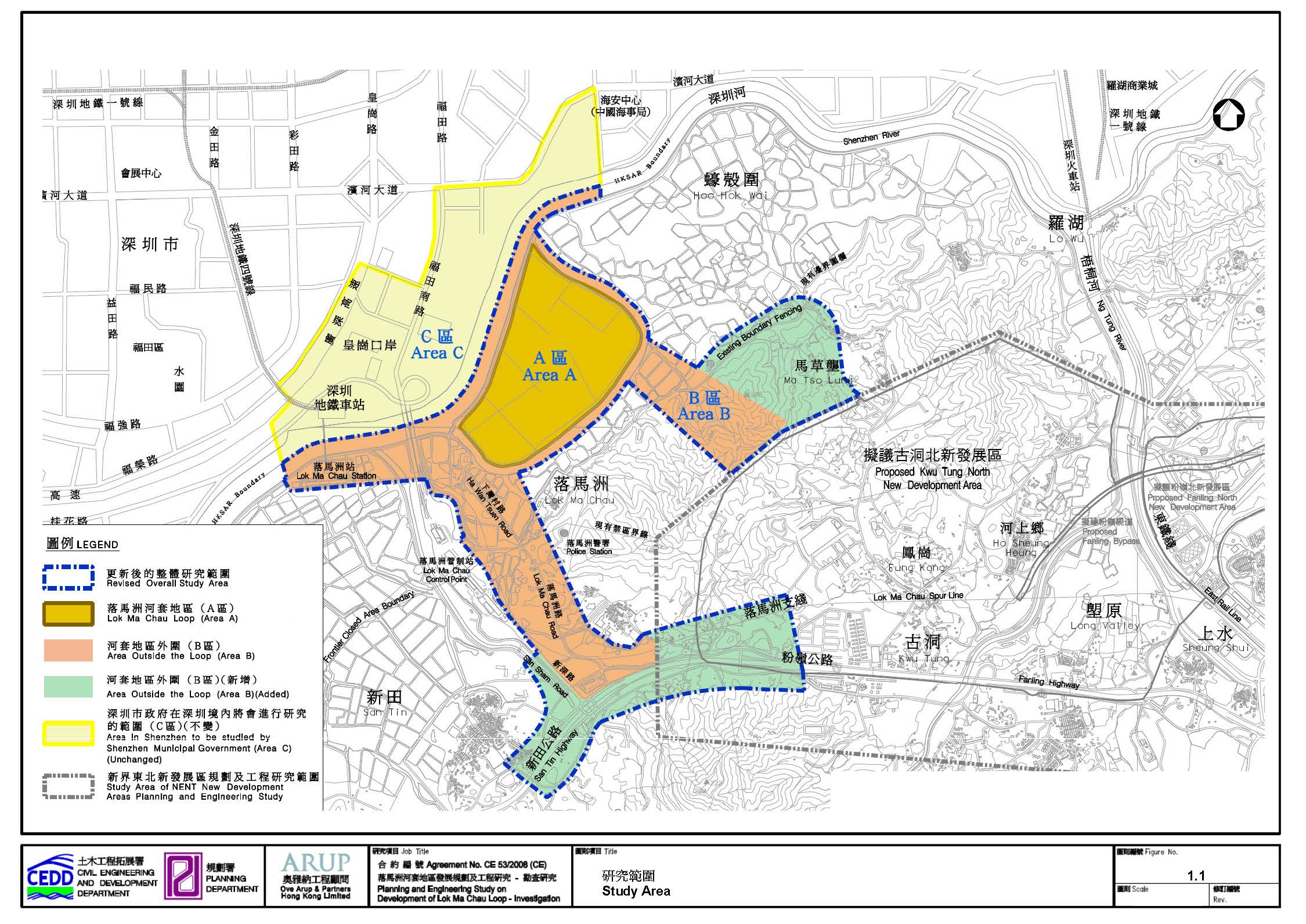
_Page_01.jpg)
_Page_02.jpg)
_Page_03.jpg)
_Page_04.jpg)