1.1.1.1 This Executive
Summary summarises the results of the Environmental Impact Assessment (EIA) for
the expansion of Hong Kong International Airport (HKIA) into a three-runway
system (3RS). The EIA accompanies an application for an Environmental Permit
(EP) and has been prepared in accordance with the requirements of the
Environmental Impact Assessment Ordinance (EIAO).
1.1.1.2 Since the opening of
the existing HKIA in 1998, airport facilities and operations have been
progressively expanding throughout the years to meet increasing demand. At the
same time, the development needs of the airport have been reviewed by Airport
Authority Hong Kong (AAHK) every five years through the preparation of a
20-year Master Plan, as part of a continuous master planning process, which
also considers the need for airport expansion. The HKIA Master Plan 2030
(MP2030) is the latest master plan prepared by AAHK.
1.1.1.3 As part of MP2030, a
three-month extensive public consultation, including a questionnaire survey,
was conducted in 2011. Members of the public were invited to comment on the
possible options as the strategic direction of the future development of HKIA.
Option 1 was to “maintain
the existing two-runway system”, and Option 2 was to “expand
into a 3RS”. The survey results, compiled by Social Sciences
Research Centre (SSRC) of the University of Hong Kong
(HKU), an independent research centre, showed that 73 % of more than 24,000
respondents preferred the 3RS. In light of this finding, the Government of the
Hong Kong Special Administrative Region (HKSAR) approved in principle the
adoption of the 3RS as the future
development option for HKIA for planning purposes on 20 March 2012, and also
approved the recommendation of AAHK to proceed with the statutory EIA.
1.1.1.4 The 3RS project
(henceforth referred to as the ‘project’) is proposed to be located on a new
land formation immediately north of HKIA in North Lantau, covering a permanent
footprint of approximately 650 ha. The project primarily comprises:
¡ New third runway with associated taxiways, aprons and aircraft stands;
¡ New passenger concourse building;
¡ Expansion of the existing Terminal 2 (T2) building; and
¡ Related airside and landside works, and associated ancillary and supporting facilities.
1.1.1.5 An EIA study brief (ESB-250/2012) for the project was issued
by the Environmental Protection Department (EPD) on 10 August 2012. The EIA
report has been prepared according to the study brief requirements, which
identified 12 key environmental assessment aspects to be addressed as part of
the EIA study. The findings of these assessments are described in Chapter 5 of this
Executive Summary.
1.1.1.6 From late 2008 to early
2014, AAHK organised and took part in 970 stakeholder engagement activities
with a variety of stakeholder groups to explain the airport’s long-term
development plan. Key channels for which some of the stakeholder engagement
activities were conducted include:
¡ Four Technical Briefing Groups (TBGs) comprising experts and academia with technical expertise in specific environmental aspects to discuss issues of noise, air quality, marine ecology and fisheries, and Chinese White Dolphins (CWD); the first round of meetings were held in September and October 2012, the second round in April and June 2013, and the last round in November and December 2013;
¡ Five Community Liaison Groups (CLGs) comprising District Councillors and Community Leaders from HKIA’s neighbouring districts (Islands, Kwai Tsing, Shatin, Tsuen Wan and Tuen Mun); meetings were held in October 2012 and June, July and December 2013;
¡ Focused consultations held with green groups in September 2012 and June, August, November and December 2013; and
¡ A Public Exhibition, held from 1 to 4 August 2013, and two sessions of public forums, which took place on 3 and 4 August 2013; both were held to update the public on the progress of the EIA and the direction for avoiding / mitigating the potential impacts of the project.
1.1.1.7 The other stakeholder
engagement activities included meetings, briefings, seminars, discussion
forums, exhibitions and airport visits. They covered a broad spectrum of
stakeholders, including professional bodies, community representatives,
industry representatives, businesses, political parties, academia,
non-government organisations, green groups, youth and media.
1.1.1.8 The feedback and advice
obtained from the various stakeholder engagement activities have been considered
and incorporated, where applicable, as part of the technical assessments
under the EIA study.
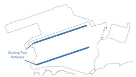
2.1
Development of Hong Kong International Airport
2.1.1.1
HKIA has long been
recognised as an important infrastructure asset supporting the economic development of Hong Kong. When the original
airport at Kai Tak began to experience constrained
operation, increasing adverse impacts on both the economy and the environment
(particularly in terms of noise) were apparent. A strategic study was carried
out including a Strategic Environmental Assessment (SEA) to consider
alternative sites for the airport. The site that was ultimately selected was Chek Lap Kok. The relocation of
the airport to Chek Lap Kok
was a strategic decision to meet the growth demand for aviation service,
prevent long-term economic loss and improve the environmental quality of the
urban Kowloon area. This decision was pivotal to enabling the success that Hong
Kong continues to enjoy, namely as one of the key players in the international
arena for the city’s economic pillars, which include finance, trade and
logistics, tourism and professional services. From an environmental
perspective, the Chek Lap Kok
location was chosen primarily because it involved much less impact when
compared to other viable options. Therefore, the Chek
Lap Kok location was seen as the best way forward at
the time for both economic and environmental considerations.
2.1.1.2
As an international aviation hub at the heart of the Asia
Pacific region, HKIA serves traffic originating or terminating in Hong Kong (origin-destination traffic) as well as transfer traffic of passengers and trans-shipment
of cargo around the world, facilitated by its capacity and 24-hour operations.
With its advantageous geographical location and highly efficient operation, air
traffic demand at HKIA has been steadily growing each year. HKIA is ranked as
the world’s busiest international cargo airport since 1996,
and third busiest airport for international air passengers in 2013. To meet
increasing demand, HKIA has grown within the physical limits of the airport
island footprint, providing new facilities and services over the years that
include terminal expansion, cross-boundary ferry service, a new satellite
concourse, and the more recent expansion of the apron and midfield areas for
additional aircraft parking stands. HKIA is now reaching its maximum handling
capacity within the existing airport island footprint.
2.2
Demand Projection
2.2.1.1
The maximum handling capacity of HKIA was originally designed
to meet the air traffic demand projected under the 1992 New Airport Master Plan
(NAMP), which estimated 376,000 air traffic movements (ATMs)1 per year by 20402. However, air traffic
demand has increased much faster than originally predicted. It was estimated in MP2030 as published in 2011 that the existing
two-runway system at HKIA would reach its practical maximum capacity sometime
between 2019 and 2022. Nevertheless, the latest review by the International Air
Transport Association (IATA) on MP2030 suggests that this practical maximum
capacity may be reached one to three years earlier than what was previously
projected and presented in MP2030.
1 Also known as
flight movements and comprises both passenger and cargo flights.
2 1992 NAMP forecast capacity by 2040 is at 87
million passengers and 8.9 million tonnes of cargo.
2.2.1.2
The increase in demand is mainly attributed to the
connectivity advantages of HKIA, coupled with the rapid development of Hong
Kong as a business and financial centre. These factors have converted HKIA from
the originally envisaged origin-destination airport (primarily serving air
traffic to/from Hong Kong) into an international hub airport (serving air
traffic to/from Hong Kong as well as traffic routing via Hong Kong). The
international hub airport status of HKIA brings additional air traffic demand
as well as a change in
aircraft mix. The latest traffic demand at HKIA is
forecast to reach approximately 607,0003 ATMs per year by 2030.
3 Latest
forecasts from IATA by 2030 is 102.3 million passengers, 8.9 million tonnes of
cargo and 607,000 ATMs
2.2.1.3
Given that future air traffic demand is also dependent on a
number of external factors, a review of other key factors that may influence
future air traffic demand in Hong Kong has been carried out, including aircraft
mix, high-speed rail service and the effect of optimisation of Pearl River
Delta (PRD) airspace on PRD airports and so forth. However, the analysis
suggests that these external factors will not significantly affect or reduce
the projected air traffic demand in Hong Kong.
2.3
Alternatives to Expanding HKIA into a Three-Runway System
2.3.1.1
Alternatives to meet the projected air traffic demand apart
from expanding HKIA into a 3RS were considered. These include optimising the
remaining two-runway capacity and cooperating with neighbouring airports. After
careful consideration, these two alternatives were found to be unfeasible for
the following reasons:
¡ Optimising the remaining two-runway capacity would be a short-term measure, as the two-runway system will soon reach its practical maximum capacity. Runway saturation will occur sometime between 2019 and 2022 according to MP2030, or one to three years earlier than the MP2030 projection based on the latest review by IATA. Beyond this point, further expansion would still be required. The delay in expanding HKIA into a 3RS would mean that the maximum runway capacity of HKIA would be reached before further expansion is completed. Optimising the two-runway capacity before developing into a 3RS would also lead to resource wastage, as the added infrastructure for upgrading the two-runway capacity would be for only a few years before redevelopment under a 3RS.
¡ Cooperation with neighbouring airports in PRD region would be difficult due to the differences in air jurisdictions and air services agreements. Furthermore, the need to transit between cities would bring inconvenience to passengers and cargo operators, and incur additional time and resource depletion affecting both the scheduling and affordability of the journey. Relying on other airports to meet Hong Kong’s air traffic demand also reduces the benefits that HKIA brings to Hong Kong’s economy and would ultimately diminish the overall competitiveness of HKIA and, by extension, Hong Kong.
2.4
Benefits of the Project
2.4.1.1
Expansion into a 3RS has been identified as the best way forward
to secure the continual growth of HKIA operation. With a 3RS, additional
benefits can be realised, including:
¡ Airport services and facilities would be further improved with the provision of new and modified passenger and airfreight facilities as well as increased operational flexibility, which would permit runway operations to better take into account the needs and concerns of nearby residents.
¡ Air connectivity would increase with the larger number of destinations served and frequency of flights to destinations, providing more choices for airport users and contributing to increased business and trade to/from Hong Kong.
¡ New jobs and direct employment at HKIA would be increased, as would indirect employment resulting from the supply of goods and services to the aviation sector and non-aviation activities at HKIA, as well as jobs that are induced from the spending of income by direct and indirect employees associated with HKIA.
¡ The contribution of HKIA to economic growth would increase by boosting gross domestic product (GDP) as a result of increased imports, exports and re-exports passing through HKIA. Hong Kong’s share of the international business and trade markets would also increase as a result of the increased international connections enabled by the expansion of HKIA.
2.4.1.2
While some environmental impacts associated with airport
expansion would be unavoidable, there are also opportunities, at the project’s
design, construction and operation stages, for incorporating positive
environmental elements into the project. These include minimisation of night-time
operations at the South Runway wherever practical; increased flexibility on
preferential use of flight tracks to minimise aircraft noise impact to
populated areas; decreased aircraft taxiing and holding times to reduce
aircraft emissions; beneficial use of fill materials generated by other
projects; and incorporation of best practice for environmental and
efficiency improvements, such as energy efficiency, water conservation and
waste recycling at airport buildings and facilities.
2.5
Consequences of Not Proceeding with the Project
2.5.1.1
Under the current two-runway system, the MP2030 study identified that the
maximum practical runway capacity was expected to be reached between 2019 and
2022. The latest forecast suggests that this maximum capacity may be reached
one to three years earlier than previously projected. In the absence of the
project, HKIA will have to operate under a constrained mode4. When this happens,
the following consequences will arise:
¡ For airport operations, service quality will deteriorate due to increased congestion and reduced flexibility to cope with, and recover from, service disruptions.
¡ For airline operations, the limited availability of landing / take-off slots would result in a reduction in available routes / destinations, which would instigate a need to seek alternative airports for expanding their flight network.
¡ For the aviation industry, growth would effectively be capped as no new routes nor increased frequency of existing routes can be made without the substitution of existing flights.
4 Constrained mode refers
to a mode of operation where demand (for aircraft landing and take-off (LTO)
slots) exceeds supply (availability of LTO slots)
2.5.1.2
These changes would then impact passengers, cargo businesses
and environmental performance as follows:
¡ Passengers would face reduced choice of destinations and flights, longer waiting / connecting times, increased travelling costs as a result of shortage in supply, and increased risk of delays.
¡ Cargo business would experience similar impacts due to loss of business associated with the reduction in destinations, increased risk of delays to delivery of goods, increased costs, reduced scheduling flexibility and the need to seek alternative airports for expanding their service.
¡ The environmental performance of the airport would worsen due to increased air traffic congestion (and associated emissions) and increased aircraft noise impacts to nearby populated areas.
2.5.1.3
Inevitably, the impacts would be far-reaching and would lead
to a reduction in the city’s status as an international aviation hub and the
overall competitiveness of Hong Kong. To avoid these consequences, expansion of
HKIA into a 3RS is considered to be the best option.
3.1
Background
3.1.1.1
The expansion of the airport requires the consideration of a
multitude of external and intrinsic factors that are inherently complex. These
factors were carefully considered as part of a number of feasibility studies
undertaken during the master planning process5.
5 These feasibility studies are published as part of the MP2030
consultation and are available via the website
http://www.threerunwaysystem.com/en/Information/Consultancy_reports.aspx
3.1.1.2
For MP2030, AAHK commissioned relevant consultants to conduct
feasibility studies covering airspace and runway capacity analysis, initial
land formation engineering evaluation, preliminary engineering feasibility and
environmental assessment, preliminary aircraft noise
impact analysis, preliminary air quality impact analysis, economic impact
analysis and financial feasibility assessment. These evaluations and
assessments provided essential input into the master planning process, enabling
identification of the various constraints and issues as well as identifying the
opportunities for optimising different components of the airport, such as the
configuration of the third runway, passenger processing terminal and passenger
concourse areas. One of the purposes of the feasibility studies was to assess
the environmental acceptability of different expansion / construction options,
which led to a number of
improvements in the environmental performance of the project, including reduced
extent of land formation, use of non-dredge methods during land formation to
minimise impacts on water quality, waste and marine ecology, and use of the
deep cement mixing (DCM) approach for ground improvement at the contaminated
mud pit (CMP) area to prevent leakage of contaminants.
3.2
Airport Layout
3.2.1.1
Considerations for the runway alignment formed the first
major foundation to the airport layout options assessment. Sixteen initial alignment
options (comprising 15 original options plus one additional option) were
identified and evaluated against a set of mandatory criteria that are crucial
to the safe and effective operation of the third runway. This screening process
narrowed the list of viable options to four alignments. Further evaluation
against operational requirements resulted in a shortlist of three viable
alignment options for further analysis. These three alignment options were
combined with airport layout options to create a total of 18 airport layout
options, covering possible permutations of passenger terminal, concourse and
aircraft apron locations. These 18 options were then evaluated against a number
of operational criteria, which resulted in a final shortlist of four airport
layout options. These final shortlisted options were subsequently taken forward
for detailed engineering and environmental evaluation.
3.2.1.2
The four shortlisted airport layout options are shown below:
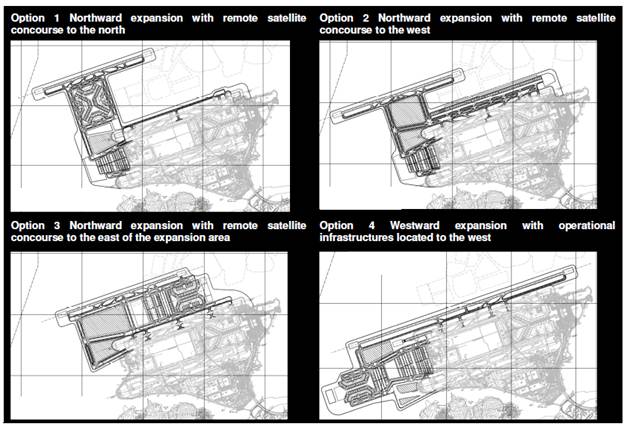
3.2.1.3
The four shortlisted options were assessed against both the
non-environmental criteria and environmental criteria. The non-environmental
evaluation comprised the following criteria:
¡ Airfield efficiency
¡ Passenger convenience
¡ Surface access
¡ Cargo operations efficiency
¡ Constructability / cost
3.2.1.4
In general, the non-environmental criteria evaluation found
that northward expansion (Options 1, 2 and 3) would provide better performance
than the westward expansion option (Option 4).
3.2.1.5
Similarly, evaluations were undertaken against the
environmental criteria. The evaluation was based on a number of key criteria,
with different rankings assigned according to the degree of potential
environmental impact associated with each airport layout option. The findings
are summarised in Table
3.1.
Table 3.1: Summary of Environmental Evaluation of
Shortlisted Airport Layout Options
|
Criteria |
Preferred Option |
Reason |
|
Air Quality |
All options would result in similar level of impact. |
All options would result in similar level of impact. |
|
CWD |
Option 3 |
Generally affects a smaller area of CWD feeding habitat and has less impact on other CWD-important areas compared to the other options. |
|
Fisheries |
Option 3 |
Generally considered to have less impact on fishery activities compared to other options. |
|
Marine Ecology |
Option 3 |
Impacts to marine ecological areas are generally less compared to other options. |
|
Noise |
Option 3 |
Generally associated with less potential aircraft noise impact compared to other options. |
|
Visual |
Option 3 |
Generally associated with less potential visual impact compared to other options. |
|
Water Quality and Hydrodynamics |
Option 3 |
Generally associated with less potential water quality and hydrodynamic impacts compared to other options. |
Note:
1. Cultural heritage – not a
key environmental differentiator as all options would have similar potential
marine archaeological impact, and no direct impacts on terrestrial cultural heritage.
2. Hazard to Human Life – not
a key environmental differentiator as all options would have similar potential
hazard to human life impacts associated with diversion of submarine aviation fuel
pipeline, extension of fuel hydrant system, and dangerous goods (DG) storage
(diesel, gasoline and liquid petroleum gas)
3. Terrestrial ecology – not a
key environmental differentiator as all options would have similar impacts
(mainly indirect impacts) to terrestrial ecology.
4. Waste – the waste
differentiator was based on previous assumptions of using dredged land
formation. As the project is now confirmed to use non-dredge methods, this
differentiator is no longer applicable.
5. Land Contamination – not a
key environmental differentiator as all options would
have similar potential impacts associated with works required at the existing
airport island.
3.2.1.6
Based on the comparison between the different airport layout
options in terms of potential environmental impacts, it was concluded that
Option 3 is associated with less overall environmental impacts. Thus Option 3
was identified as the best-performing option. While taking forward this
preferred option for further evaluation, additional environmental enhancements
were identified and subsequently made to the preferred option. These included a
substantial reduction of the land formation area (from approximately 827 ha to
approximately 650 ha). Other major components of the airport, including T2
expansion and the new third runway concourse (TRC) layout, were also evaluated
against various criteria to determine the best-performing option. The outcome
of these evaluations was the preferred airport layout (shown in Drawing
No. MCL/P132/ES/3-001), which has been adopted in this EIA study.
3.3
Construction Methods
3.3.1 Land Formation
3.3.1.1
From an early stage, it was
identified that only the non-dredge method, which involves ‘filled’ land formation, would meet the long-term operational
requirements of the project while minimising the environmental impact
associated with land formation. As the project will be partly formed over the
historical capped CMPs, the evaluation of ground improvement options was one of
the key requirements to ensure minimal disturbance to the capped CMPs. A total
of 11 ground improvement options were initially compared and evaluated on
technical feasibility and environmental acceptability. The results of the
evaluation produced a shortlist of six options (cylindrical steel cells, DCM, prefabricated vertical drains, sand compaction piles, stone
columns and vertical sand drains) that were considered to be technically and
environmentally acceptable. However, only one option, namely, DCM, was found to be environmentally
acceptable for application within the CMP area. This non-dredge method differs
from the other methods in that it provides in-situ treatment and stabilisation
of the marine sediment, which reduces the potential for release of contaminated
pore water. Based on research findings on overseas application of this method,
the results of a previous trial6 in Hong Kong and consultation with EPD, it was concluded
that only the DCM method would be applied within the CMP area for land
formation works. Recognising the benefits of this approach, DCM is also
proposed for other marine infrastructure works within the CMP area, such as the
piles for the new runway approach lights.
6 A DCM trial was carried out at the CMP area in February 2012, during
which extensive water quality and underwater noise monitoring was performed to check for any potential environmental impacts. The monitoring results indicated that the DCM work would not cause any appreciable deterioration of water quality, and no leakage of contaminants
or cement slurry was detected throughout the trial process. It was also found that the DCM work was relatively quiet compared
to other marine construction techniques, and the underwater noise generated was typically below 200 Hz, which is a frequency of low
sensitivity for CWD. Therefore, the field trial has demonstrated that DCM is an environmentally acceptable ground improvement
method at the CMP area.
3.3.1.2
Consideration was also given to various seawall design
options, taking into account engineering requirements, environmental benefits
and other considerations. The findings of the evaluation identified rockfill
sloping seawalls as presenting an environmental advantage from the perspectives
of waste minimisation and marine ecological habitat. Taking into account all
other applicable factors, rockfill sloping seawalls, comprising either mound
core or circular steel cell cofferdam, were identified as the preferred options
to be implemented as the dominant seawall types for the project. However, the
adoption of vertical seawall design would be required at local areas with
specific operational requirements, such as sea rescue berths.
3.3.1.3
After completion of land formation, various facilities would
be constructed on the existing and expanded airport area, including (but not
limited to) the third runway, taxiways, aprons, TRC, T2 expansion, tunnels,
road networks, drainage, sewerage, utilities, fuel hydrant system and various
ancillary buildings of the project. These will generally comprise standard
construction methodologies that, with the implementation of recommended
mitigation measures, are not anticipated to result in significant variations to
the environmental performance of the project.
3.3.2 Marine Infrastructure Diversion
3.3.2.1
Key existing marine infrastructure elements will require
diversion as part of the project, including the existing submarine aviation
fuel pipelines and the submarine 11 kV cables.
3.3.2.2
The existing airport island is currently supplied with
aviation fuel via submarine aviation fuel pipelines that originate from the
permanent aviation fuel facility at Tuen Mun. These pipelines route via the
aviation fuel receiving facility at Sha Chau before connecting to the existing
aviation fuel tank farm on the airport island. As the land formation for the
airport expansion will cover part of the existing alignment of the submarine
pipelines, these pipelines will need to be diverted prior to commencement of
land formation. Three alignment / construction options were evaluated as part
of the scheme design for this project for diverting the submarine aviation fuel
pipelines. Two of these options involve open trench excavation from the airport
island to Sha Chau, while the remaining option involves drilling through
bedrock using the horizontal directional drilling (HDD) method. All three
options were evaluated from the perspectives of design, construction,
environment and inspection and maintenance. The results of the evaluation
identified the HDD method to be the option with the least potential for environmental
impacts. This method was subsequently adopted as the preferred option for
diverting the submarine aviation fuel pipelines.
3.3.2.3
Similarly, an evaluation was undertaken for the existing
submarine 11 kV power cables. These cables provide power supply from the
northwest of the airport island to various facilities located on Sha Chau and
Lung Kwu Chau islands. As the land formation for the airport expansion will
cover part of the existing alignment of the submarine cables, these cables will
need to be diverted prior to commencement of land formation. A total of five
alignment / construction options were evaluated from both technical and
environmental perspectives. Three of the options involve direct bury methods
from the airport island to Sha Chau. One involves direct bury method from the
airport island to a ‘mid-point’ outside the Sha Chau and Lung Kwu Chau Marine
Park (SCLKCMP), whereby the diverted cable would subsequently be connected to
the existing cable via a field joint. The remaining option involves drilling
through bedrock using the HDD method. Of the five options, the HDD method was
identified to be technically infeasible due to the high risk of damage to the
power cables; thus this option was not considered further. Of the remaining
four options, the option with the least environmental impact was identified to
be the direct bury method with field joint, as this method avoids encroachment
into the ecologically sensitive Marine Park. This method was subsequently
adopted as the preferred option for diversion of the submarine 11 kV power
cables.
4.
Project Description
|
4.1
Key Project Components
4.1.1.1 Based on the preferred
airport layout (shown in Drawing No. MCL/P132/ES/3-001), the
key project components include:
¡ Land formation comprising ground improvement, seawall construction and modification (including sea rescue boat points), filling and surcharge activities;
¡ Construction of new airfield facilities including the third runway, taxiways, aprons, aviation fuel supply network and other airfield infrastructure, aircraft navigational aids, approach lighting system and new Hong Kong International Airport Approach Area (HKIAAA) marker beacons;
¡ Modification of existing airfield facilities, including the existing North Runway, taxiways and aprons in the Midfield area;
¡ Construction of new passenger facilities including the TRC and expansion of T2, the automated people mover (APM) system and associated depot and maintenance / stabling areas, and the baggage handling system (BHS);
¡ Construction of new ancillary facilities to support the operational needs of the expanded airport, including utility buildings, airport support developments, air cargo staging, catering, aircraft maintenance, aircraft engine run-up (engine testing) facilities, ground service equipment (GSE) area, early bag storage facility, fire station, fire training facility, petrol fuelling station, new air traffic control towers (ATCT), Hong Kong Observatory (HKO) facility, mobile phone system antenna towers, stores, security gate houses, etc.;
¡ Construction of new and expanded infrastructure and utilities, including road networks, seawater cooling and flushing system, stormwater drainage system, greywater system, sewerage network and potable water supply, Towngas supply, 132 kV / 11 kV and other power supply networks, communication networks, etc.;
¡ Diversion of existing submarine infrastructure, including the submarine aviation fuel pipelines and submarine 11 kV cables.
4.2
Construction Programme
4.2.1.1
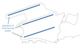
The tentative programme for the project is for the 3RS to be
operational in 2023. Given the scale and complexity of the project, the
construction and concurrent runway operational configuration will be
implemented in phases as shown in Table 4.1 below. Some components, such as the TRC, may be
constructed in phases based on the level of demand. Due to such
phasing arrangement, the three-runway airfield system will be in operation
before the full completion of all infrastructure associated with the project.
Table 4.1: Summary of Construction and Runway
Operational Configuration Phasing
|
Phase |
Description |
Runway Operational
Configuration |
Timeframe |
|
Advanced Works |
Diversion of the submarine pipelines
and power cables |
|
2015 to 2016 |
|
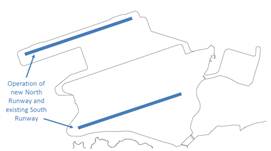
Phase 1 |
Land formation works will commence before subsequent construction of third runway, new taxiways and the new TRC. Expansion of T2 will also commence. The existing two-runway system remains operational throughout the construction phase. |
2016 to 2021 |
|
|
Phase 2 |
Upon completion of the third runway and associated taxiways, the existing North Runway will be closed for modification works, while construction activities for the TRC and aprons, vehicle tunnels and reconfiguration of T2 are on-going. During this interim period, the South Runway and the new third runway will be operational. |
|
2021 to 2023 |
|
Phase 3 |
Upon completion of all essential infrastructure and facilities, including part of the TRC and aprons and expanded T2, the airport will operate under the 3RS. Construction of the remaining facilities will continue until completion. |
|
2023 and after |
4.3
Summary of Designated Projects
4.3.1.1
The project components that constitute a Designated Project
under the EIAO are listed as follows:
¡ Reclamation works (including associated dredging works) more than 5 ha in size (Item C.1, Part I, Schedule 2).
¡ An airport (including its runway and the development and activities related to aircraft maintenance, repair, fueling and fuel storage, engine testing or air cargo handling) (Item B.1, Part I, Schedule 2).
¡ A railway and its associated stations (Item A.2, Part I, Schedule 2).
¡ A road or railway tunnel more than 800 m in length between portals (Item A.7, Part I, Schedule 2).
¡ An activity for the reuse of treated sewage effluent from a treatment plant (Item F.4, Part I, Schedule 2).
¡ A submarine gas pipeline or submarine oil pipeline (Item H.2, Part I, Schedule 2).
¡ All projects including new access roads, railways, sewers, sewage treatment facilities, earthworks, dredging works and other building works partly or wholly in an existing or gazetted proposed country park or special area, a conservation area, an existing or gazetted proposed marine park or marine reserve, a site of cultural heritage, and a site of special scientific interest (Item Q.1, Part I, Schedule 2).
¡ A road which is an expressway, trunk road, primary distributor road or district distributor road including new roads, and major extensions or improvements to existing road (Item A.1, Part I, Schedule 2).
¡ A railway siding, depot, maintenance workshop, marshalling yard or goods yard (Item A.4, Part I, Schedule 2).
¡ A road or railway bridge more than 100 m in length between abutments (Item A.8, Part I, Schedule 2).
¡ Reclamation works (including associated dredging works) more than 1 ha in size and a boundary of which is less than 100 m from a seawater intake point (Item C.2(b), Part I, Schedule 2).
¡ A cement works or concrete batching plant with a total silo capacity of more than 10,000 tonnes in which cement is handled and manufactured (Item K.5, Part I, Schedule 2).
¡ A sand depot with a site area of more than 1 ha in size (Item K.11, Part I, Schedule 2).
4.4
Concurrent Projects
4.4.1.1
A review of available information during preparation of the
EIA identified a number of other planned / committed projects that may be
implemented around the same time as this project, and which may contribute to
cumulative environmental impacts. Where applicable, these concurrent projects
have been considered and incorporated into relevant technical assessments as
part of this EIA report.
5.1
Approach to
Environmental Impact Assessment
5.1.1.1 The EIA process
provides a means of identifying, assessing and reporting the environmental
impacts and benefits of the project. It is an iterative process that has been
followed in parallel with the design process to identify the potential
environmental effects of various design options, and develop alternatives as
well as mitigation measures to be incorporated into the design, construction
and operation of the airport expansion. AAHK has considered and incorporated
the feedback and advice obtained from the various stakeholder engagement activities into the EIA process where appropriate. AAHK has also come up with measures
that can avoid some potential environmental impacts, while others are minimised
or mitigated to acceptable levels.
5.2
Overview of Impact Avoidance, Minimisation and
Mitigation Measures
5.2.1.1 On the basis of the
preliminary engineering and environmental assessments undertaken during the
preparation of MP2030, and the subsequent EIA study, a number of environmental
considerations have been identified and integrated into the project. AAHK is
committed to implementing the following key design and planning initiatives to improve environmental performance:
Minimising Land
Formation Footprint
5.2.1.2 After detailed
evaluation of a range of airport layout options, a preferred option has been
selected to achieve the best balance among various key environmental factors,
operational efficiency and engineering constraints. Nevertheless, further
enhancements have been made to the preferred option, which include, among
others, substantial reduction of the land formation area from approximately 827
ha to approximately 650 ha. A key driver for the reduction was to minimise
associated impacts on marine habitat and its marine life, including CWD.
Avoiding / Minimising
Construction Phase Impacts
5.2.1.3 Non-dredge ground
improvement methods (e.g., DCM) will be used for land formation in order to avoid
bulk removal and disposal of any dredged materials, as well as to minimise
suspended solids (SS) and contaminants
release. The use of this method will substantially reduce the potential impacts
to surrounding marine water quality and marine ecology, including CWD.
5.2.1.4 The HDD method will be
deployed through the deep rock stratum below the seabed for diversion of the
submarine aviation fuel pipelines from the airport island to Sha Chau to avoid
dredging of any seabed, thereby eliminating any impacts on marine water quality
and marine ecology, including impacts on the SCLKCMP. In addition, the
daylighting location of the fuel pipelines (i.e., the point where the pipelines
surface at ground level) on Sheung Sha Chau Island has been carefully selected
to minimise disturbance to the egretry on the island.
5.2.1.5 The water jetting
method will be adopted to lay new submarine 11 kV cables for connection to the
existing cables at over 500 m from the boundary of the SCLKCMP. The use of this
method will minimise the generation and disposal of marine sediment and avoid
disturbance to the seabed inside the Marine Park.
5.2.1.6 During the design and
construction planning process, priority was given to maximise, as far as
practicable, the reuse of inert construction and demolition (C&D) materials
generated by the project, including rock armour from the removal of the
existing northern seawall for the land formation works. This will minimise
off-site delivery of the surplus inert C&D materials and the associated
environmental impacts. Optimising the use of C&D materials on site will be
balanced with maximising, as far as practicable, the use of public fill
materials from the Government’s public fill reception facilities (PFRF), i.e., unwanted fill materials from other projects in Hong Kong,
for the project’s land formation works.
5.2.1.7 All marine sediment
that will be excavated as a result of the various construction works on the
expanded airport island will be treated and reused on-site as backfilling
materials for the project, in accordance with the relevant requirements. This
approach avoids the need for off-site disposal which could result in impacts on
the marine environment.
Minimising Aircraft and
Related Emissions and its Potential Health Impact
5.2.1.8 AAHK is committed to
reducing, where practicable, the potential air quality and health impacts
associated with airport and its associated operations. As such, a number of
initiatives have already been put in place to minimise emissions of air
pollutants. These initiatives include enforcing the use of fuel-efficient
airside vehicles through mandatory requirement in the licensing process;
promoting increased use of electric vehicles and electric GSE
at HKIA by providing charging infrastructure and progressively replacing the
entire vehicle fleet with electric or fuel-efficient / hybrid vehicles, with
the aim of replacing all saloon vehicles on the airside by electric vehicles by
2017; banning all idling vehicle engines on the airside since June
2008, with the exemption of certain vehicles and equipment due to safety and
operational considerations; provision of the cleanest diesel and gasoline at the
airfield; requiring all of AAHK’s diesel vehicles to use biodiesel (B5); and
providing liquefied petroleum gas (LPG) fuelling points for airside vehicles
and GSE.
5.2.1.9 Furthermore, AAHK is
increasing the use of fixed ground power and pre-conditioned air systems, which
currently has an approximately 80% usage rate for aircraft parking at frontal
stands. AAHK will also ban aircraft from using auxiliary power units (APU)
at frontal aircraft parking stands by end of 2014.
Minimising Aircraft
Noise and Potential Health Impact
5.2.1.10 In order to minimise
aircraft noise and the associated health impact, a number of planned
operational procedures will be incorporated into the future operation of the
proposed 3RS, which include:
(i)
Putting the South Runway on standby where possible at night
between 2300 and 0659;
(ii)
Requiring departures to take the southbound route via West
Lamma Channel during east flow at night from 2300 to 0659, subject to
acceptable operational and safety consideration. This is an arrangement that is consistent
with the existing requirement in the operation of the two-runway system at
night;
(iii) A new arrival Required
Navigation Performance (RNP7) Track 6 has been
designed for preferential use in the west flow direction (i.e., runway 25 direction)
between 2300 and 0659 and it is assumed that up to 95% of flights may
preferentially use this new Track 6 instead of the existing straight-in tracks
by year 2030; and
(iv) Implementing a
preferential runway use programme when wind conditions allow such that west
flow is used when departures dominate while east flow is used when arrivals
dominate during night-time.
7 RNP is a method of navigation which permits aircraft operations on
any desired flight path within the coverage of station-referenced navigation
aids or within the limits of the capability of self-contained aids, or a
combination of these, with the addition of an on-board performance monitoring
and alerting capability.
Mitigation of
Unavoidable Impacts
5.2.1.11 While environmental impacts associated with the construction and
operation of the project will be avoided/ minimised by implementing the aforementioned key design and planning strategies, the project will
inevitably give rise to some impacts on the environment. Therefore, detailed
and comprehensive assessment of the environmental impacts has been carried out
and, where necessary, appropriate mitigation measures have been established to
further alleviate the potential impacts. A summary of the major assessment
findings is presented in the following sections. Details of specific mitigation
measures are included in the relevant sections of the main EIA report.
5.3
Air Quality
5.3.1
Introduction
5.3.1.1
Potential air quality impacts associated with the
construction and operation phases of the project have been assessed in
accordance with the criteria and guidelines as stated in the requirements given
in Section 3.4.3 and Section I of Appendix A of the EIA study brief, as well as
Section 1 of Annex 4 and Annex 12 of the Technical Memorandum on EIA Process
issued under the EIAO (EIAO-TM).
5.3.1.2
Quantitative assessment using the relevant air models
approved by EPD was performed for both the construction and operation phase
impact assessments.
5.3.2
Construction
Phase
5.3.2.1 The
key activities that could potentially result in dust emissions during
construction phase of the project have been identified.
These activities include land formation works; construction of the third
runway, a passenger concourse, the apron and relevant airfield infrastructure
facilities; expansion of the existing T2 and part of the midfield freighter
apron; extension of the APM and BHS; improvement of relevant road networks; rock crushing plants; diversion of the submarine aviation fuel pipelines and submarine 11 kV cables; modification of existing outfalls; and the concrete
batching plants, asphalt batching plants and barging points. In addition, construction dust
emissions from concurrent projects within the 500 m assessment area have also
been identified and included in the cumulative air quality impact assessment
where appropriate.
5.3.2.2 According to Clause 3 (ii) under Section I of Appendix
A of the EIA Study Brief, representative air sensitive receivers (ASRs) within 500 m from the project
boundary were identified for air
quality impact assessment during the construction phase. The air pollutants of
interest in the assessment include Total Suspended Particulates (TSP),
Respirable Suspended Particulates (RSP or PM10) and Fine Suspended
Particulates (FSP or PM2.5).
5.3.2.3 With the implementation
of the recommended mitigation measures and relevant control
requirements8 as part of the construction works, it has been assessed by the use of quantitative
modelling that the hourly TSP criterion would be complied with at all ASRs, and compliance with the corresponding
Air Quality Objectives (AQO) for RSP and FSP would be achieved at all ASRs throughout the whole construction period. Therefore, no adverse residual TSP, RSP or FSP impacts are anticipated
at any ASRs during the construction phase of the project.
8 Air Pollution Control (Construction Dust)
Regulation, EPD’s Guidance Note on the Best Practicable Means for Cement Works
(Concrete Batching Plant) BPM 3/2(93), Guidance Note on the Best
Practicable Means for Tar and Bitumen Works (Asphaltic Concrete Plant) BPM 15
(94) and Guidance Note on the Best Practicable
Means for Mineral Works (Stone Crushing Plants) BPM 11/1 (95)
5.3.2.4
During the proposed DCM process that would
be carried out as part of the ground improvement works for land formation,
cement powder will be transferred from supporting vessels to DCM barges through piping in closed loop, or in a totally
enclosed manner. There will be no open storage of cement on the DCM barges or supporting vessels. Therefore, no adverse
residual dust impacts due to cement transfer or storage are anticipated.
5.3.2.5
There is potential for emissions associated with bitumen
fumes from the proposed asphalt batching plants at the airport expansion area.
However, given their large separation distances from ASRs (at least 3.1 km from
the nearest ASR) and with the implementation of various emission control
measures as given in the EPD’s Guidance Note on the Best Practicable Means for
Tar and Bitumen Works (Asphaltic Concrete Plant) BPM 15 (94), adverse residual air quality impacts due to bitumen fume emissions are not
anticipated.
5.3.2.6
In view of the above assessment findings, construction of the
project will not result in adverse residual air quality impacts.
5.3.3
Operation
Phase
5.3.3.1
There are various key air emission sources due to airport operation,
which include emissions from the aircraft landing and take-off
(LTO) cycle; use of APUs during aircraft ground operation;
the aircraft
maintenance centre; engine testing facilities;
operation of Government flying service (GFS), including fixed wing aircraft and
helicopters; ferry operation
at SkyPier; operation of airside vehicles, including GSE and
non-GSE; aviation
fuel tank farm operation; operation of the Hong Kong Business Aviation Centre; car park operation; catering
facilities;
fire training activities; and use of motor vehicles on the airport island.
5.3.3.2 Based on the trends of
future aircraft emissions forecast by the International Civil Aviation
Organization (ICAO), as well as the air traffic forecast prepared by IATA for
the 3RS project, the highest aircraft emissions scenario would occur in Year
2031, which is therefore selected as the year of assessment.
5.3.3.3
Existing and planned air emission sources within 5 km of the project boundary (i.e., the boundary of the expanded
airport island) have been identified and included in the operation phase
air quality assessment. Other far-field air emission sources
(i.e., those outside the 5 km assessment area from the airport boundary) are
collectively considered as background emissions that contribute to the ambient
air pollutant concentrations in the study area. The background contributions
comprise various sources covering the Guangdong Province, Pearl River Delta Economic Zone and HKSAR.
5.3.3.4
In determining the emission inventories for airport operation,
nearby infrastructure and ambient emissions,
both committed policies and practical technology advancement have been
considered. AAHK has been implementing a number of measures
and initiatives
aimed at further reducing air emissions from airport activities
and operations, and air quality will remain a key focus of AAHK’s environmental
plan, including:
¡ Banned all idling vehicle engines on the airside since 2008, except for certain vehicles that are exempted ;
¡ Banning the use of APU for all aircraft at frontal stands by end-2014;
¡ Requiring all airside saloon vehicles to be electric by end-2017;
¡ Increasing charging stations for electrical vehicles (EVs) and electric GSE to a total of 290 by end-2018;
¡ Conducting a review on existing GSE emissions performance and exploring measures to further control air emissions;
¡ Exploring with franchisees the feasibility of expediting replacement of old airside vehicles and GSE with cleaner ones during tender or renewal of contracts;
¡ Requiring all new airside vehicles to be fuel-efficient, and making it a prerequisite for the licensing process;
¡ Providing the cleanest diesel and gasoline at the airfield;
¡ Requiring all of the AAHK’s diesel vehicles to use biodiesel (B5); and
¡ Providing an LPG fuelling point for airside vehicles and GSE.
5.3.3.5 It is anticipated that
with implementation of the above measures, air emissions associated with
operation of the 3RS will be further reduced.
5.3.3.6
According to Clause 4 (i) under Section I of Appendix A of
the EIA Study Brief, the operational air quality impact within 5 km of the
project boundary shall be quantified. As such, the 5 km boundary from the
project site was taken as the study area, which generally covers the entire
area of Tung Chung, San Tau, Sha Lo Wan, San Shek Wan, Siu Ho Wan and Sham Wat
Wan in North Lantau, and Tap Shek Kok in Tuen Mun.
5.3.3.7
Representative ASRs within 5 km of the project boundary have
been identified. Existing ASRs, which mainly include residential buildings,
educational institutions and hotels, have been identified by reviewing
topographic maps, aerial photos and land status plans, supplemented by site
inspections. Planned / committed ASRs have been identified by making reference
to the relevant Outline Zoning Plans (OZP), Outline Development Plans, Layout Plans
and other published plans in the study area. They include:
¡ Chek Lap Kok OZP (No. S/I-CLK/12);
¡ Tung Chung Town Centre Area Layout Plan – Lantau Island (L/I-TCTC/1F);
¡ North Lantau New Town Phase IIB Area (Part) Layout Plan (L/I-TCIIB/1C);
¡ Sha Lo Wan Village Layout Plan (L/I-SLW/1);
¡ Tung Chung Town Centre Area OZP (S/I-TCTC/18);
¡ Siu Ho Wan Layout Plan (No. L/I-SHW/1); and
¡ Tuen Mun OZP (No. S/TM/31).
5.3.3.8
A Planning and Engineering Study on the remaining development
in Tung Chung is being undertaken by the Civil Engineering and Development
Department (CEDD). The objective of the study is to assess the feasibility of
the remaining development located in the east and west of Tung Chung.
Representative ASRs have been selected at the site boundary of the proposed
Tung Chung New Town Development Extension in the air quality study of this EIA.
5.3.3.9
Near-field models accepted by EPD
(i.e., AERMOD, CALINE4) and the regional model developed by EPD (i.e., PATH)
were adopted to predict the pollutant concentrations at the ASRs. Both the
two-runway system (2RS) scenario (i.e., “without project” scenario) and 3RS
scenario (i.e., “with project” scenario) have been modelled.
5.3.3.10 The model results for the Year 2031 3RS scenario indicate that
cumulative nitrogen dioxide (NO2), RSP, FSP, sulphur dioxide (SO2)
and carbon monoxide (CO) levels comply with the relevant AQOs at all ASRs. The
annual average NO2 and FSP concentration contours at 1.5 m
above ground are shown in Drawing
No. MCL/P132/ES/5-3-001 and MCL/P132/ES/5-3-002,
respectively,
which show compliance of the relevant AQOs in the air sensitive areas outside
the airport. For the airport island, in addition to continuous outdoor
air quality monitoring, AAHK also monitors indoor air quality to maintain a
quality environment for passengers and staff. Terminal 1, Terminal 2, SkyPier
and the North Satellite Concourse have achieved and maintained a “Good Class”
indoor air quality under EPD’s “IAQ Certification Scheme for Offices and Public
Places”.
5.3.3.11 On comparing the annual pollutant levels of the 3RS scenario with those
of the 2RS scenario (i.e., “without project” case), the increase in annual NO2,
RSP and FSP are less than 1mg/m3, 0.2 mg/m3 and 0.1 mg/m3 respectively,
indicating relatively insignificant changes.
5.3.3.12
With respect to the incremental changes in the annual
concentration of NO2 in Sha Lo Wan (i.e., 3RS – 2RS), which is downwind of
the airport (the prevailing wind at the airport is easterly), a decrease in concentration is predicted. This suggests that the 3RS
will bring environmental
benefit to the receivers at Sha Lo Wan and the
contributing factors include:
¡ Shifting of dominant aircraft departure from the South Runway (2RS scenario) to the centre runway (3RS scenario); and
¡ Assigning the South Runway as standby mode wherever practicable during the night-time period between 2300 and 0659.
5.3.3.13
NO2 is the key air pollutant
associated with airport operations. The source contribution breakdown for the
cumulative annual average NO2 impact at the key sensitive areas
under the 3RS scenario is shown in Table 5.1. The dominant emission sources are from ambient
emissions, which contribute in most cases more than 60% of the total NO2
concentrations. Except for Sha Lo Wan, this is followed by proximity
infrastructure emissions (10 – 30%) and airport-related
emissions (< 10%).
Table 5.1: Annual Average NO2 Source Contribution Breakdown for 2031
(3RS) Scenario
|
Area |
Cumulative Impact (mg/m3) |
Ambient Emissions (mg/m3) |
Proximity Infrastructure Emissions (mg/m3) |
Airport Related Emissions (mg/m3) |
|
Tung Chung |
33 |
22 |
9 |
2 |
|
Tung Chung West |
30 |
22 |
6 |
2 |
|
Tung Chung East |
28 |
22 |
4 |
2 |
|
Sha Lo Wan |
36 |
20 |
4 |
12 |
|
Tuen Mun[1] |
38 |
27 |
9 |
2 [1] |
Note:
[1]
Airport-related emissions are included in ambient emissions in PATH model for
Tuen Mun area.
5.3.3.14 In view of the above
assessment findings, it can be concluded that operation of the project will not
result in adverse residual air quality impacts.
5.4
Hazard to Human Life
5.4.1 Introduction
5.4.1.1 Development of the 3RS will require the existing aviation fuel hydrant
system to be extended and extra hydrant pumps to be installed at the existing
aviation fuel tank farm (AFTF). Due to the land formation for the 3RS, the
existing submarine aviation fuel pipeline lying underneath the proposed land
formation will also need to be diverted.
5.4.1.2 In accordance with the
EIA study brief, a hazard assessment has been conducted to evaluate the risk due to:
¡ Construction works near the existing aviation fuel pipelines and storage facilities;
¡ Operation of new aviation fuel pipelines (submarine and underground) and new fuel hydrant systems for aircraft refuelling operations at the new aircraft stands in the airport expansion area; and
¡ New facilities for the storage of dangerous goods (DG), i.e., fuel for airside vehicles / GSE.
5.4.1.3
In the assessment, the hazardous scenarios associated with
these activities were identified and a quantitative risk assessment (QRA) was
conducted to determine both the individual and societal risk levels based on a
set of identified hazardous scenarios. The major tasks involved in the QRA
included hazard identification, frequency assessment, consequence modelling,
risk summation and identification of mitigation measures. The evaluated risk
levels were compared with the criteria for evaluating hazard to human life as
stipulated in Annex 4 of the EIAO-TM.
5.4.1.4
Hazard identification involved conducting a review of the
historical incidents that have occurred at HKIA and airports worldwide, as well
as conducting a hazard identification workshop using ‘Structured What If’
technique. The identified
hazardous scenario(s) were then further assessed as part of the frequency assessment, using fault tree analysis and event tree
analysis techniques to analyse the hazard frequencies.
The updated hazard rates have been inputted into the RiskTool model to evaluate
the overall individual and societal risk.
5.4.1.5
Consequence analysis was
undertaken to determine the amount of leakage of jet fuel and airside
vehicle fuel (gasoline
and diesel) under each of the identified
scenarios, and the corresponding safety risk to working staff and travellers
was assessed. The software PHAST was used for the consequence modelling
for vehicle fuel, while the software PoolFire6 thermal radiation model was used
for the consequence modelling for jet fuel pool fire.
5.4.1.6
The risk summation was carried out using the RiskTool program
to generate both the individual and societal risk levels. Safety measures were
identified during the hazard identification workshop, and cost benefit analysis
was undertaken for risk levels falling into the As Low As Reasonably Practicable (ALARP) region.
5.4.2
Potential
Hazard and Risk
5.4.2.1
Offsite individual risk during
both the construction phase and operation phase was below the criterion of 1 x 10⁻⁵ per year (i.e., less than 1 in
100,000 chance of death per year); therefore, they comply
with the Hong Kong Risk Guidelines as stipulated in Annex 4 of the EIAO-TM.
5.4.2.2
For societal risk, construction
phase risk is dominated by potential impact due to the construction of the new
submarine pipeline adjacent to the existing submarine pipelines, and
construction of the airside tunnels adjacent to the existing underground
pipeline serving Terminal 1 and the Midfield. Total societal risk was assessed to be within the acceptable region.
5.4.2.3
Total societal risk during the
operation phase is dominated by the risk associated with operating the aviation
fuel hydrant pit valves, and this was assessed to be within ALARP region.
Uncertainty analysis was conducted, which concluded that the uncertainty had
been minimised by adopting conservative assumptions / parameters. This provides
confidence that the risk level assessed during the operation phase would not exceed the Hong Kong Risk
Guidelines.
5.4.2.4
A range of further mitigation
measures has been recommended to be implemented for the 3RS project in order to further reduce risk level. Construction phase mitigation measures to reduce the
risk level identified in the study include, for example, implementing
precautionary measures for marine traffic management, clear instructions to
construction workers on avoidance of existing hydrant networks / pipeline
locations, and conducting tests and inspecting pipeline integrity prior to
commissioning. Operation phase mitigation measure includes improvement audits
to reinforce existing refuelling practices and achieve better compliance.
5.4.2.5
With the implementation of the
mitigation measures, the risk is considered to be within the ALARP region and
complies with the Hong Kong Risk Guidelines.
5.5
Noise Impact
5.5.1
Introduction
5.5.1.1 Potential noise impacts
associated with the construction and operation phases of the project have been
assessed in accordance with the technical requirements stipulated in Section
3.4.5 and Section I of Appendix C of the EIA study brief, as well as Annexes 5
and 13 of the EIAO-TM.
5.5.2
Aircraft
Noise
5.5.2.1 An aircraft noise
assessment (ANA) was prepared in accordance with the requirements stipulated in
the EIA study brief. Noise criteria, in
terms of noise exposure forecast (NEF) 25 and 30 as stipulated in the EIAO-TM,
were adopted in the ANA. The assessment covers the entire Hong Kong with
particular emphasis on those areas under and near the flight tracks, and in the
vicinity of HKIA.
5.5.2.2 The ANA was carried out
in accordance with the guidelines set out by the ICAO and Federal Aviation
Administration (FAA). The FAA’s integrated noise model (INM) Version 7.0dsu1
(released in late May 2013, with a service update released in September 2013)
was adopted for quantitative assessment, and the results were
presented in
the form of aircraft noise contours in NEF metrics. Data derived
from the air traffic forecast developed by IATA9, and
Total Airspace and Airport Modeler (TAAM) simulations undertaken by National
Air Traffic Services (NATS) based on the IATA’s air traffic forecast, were
employed as key data inputs for noise modelling. The assumptions, input data,
operational modes, noise sources inventory and mitigation measures adopted for
assessments have been confirmed with the Civil Aviation Department (CAD).
9 Includes number
of aircraft arriving and departing from HKIA, origin and destination of each
flight, type of aircraft, and cargo or passenger aircraft, projected up to
2038.
5.5.2.3 In addition, a
NEF contour map based on the aviation operation data for HKIA in 201110, utilising operational records and radar data provided
by CAD, was prepared as part of the study to describe the
prevailing aircraft noise environment.
10 Year 2011 is employed to
represent the prevailing noise environment because the full-year data set in
2011 is the latest information available at the commencement of the assessment
and is considered representative of the
prevailing aircraft noise environment.
5.5.2.4
In addition to the existing measures, CAD has been exploring
other measures and new initiatives that could be implemented in the near term
with a view to further reducing the aircraft noise impact arising from the
existing operation of HKIA. Since
February 2012, CAD has implemented a set of flight procedures whereby aircraft
which are capable to use satellite-based navigation technology, when departing
to the northeast of HKIA, can adhere closely to the nominal flight track when
making the turn to the West Lamma Channel, thereby keeping the aircraft at a
distance away from the areas in the vicinity of the flight paths and reducing
the noise impact on these areas.
5.5.2.5
Furthermore, all subsonic jet
aircraft landing or taking off in Hong Kong have already been required to meet the noise standards
stipulated in Chapter
3 of Annex 16 Volume I, Part II to the Convention on International Civil
Aviation (“Chapter 3 standards”) since July 2002. To further improve the local
noise environment and alleviate the impact of aircraft noise on local
communities, with effect from end of March 2014, CAD would not allow airlines
to schedule the noisier marginally compliant Chapter 3 (MCC3) aircraft, which
are defined as per CAD’s Aeronautical
Information Circular 32/13 dated 26 November 2013, to operate between 2300 and 0659 (MCC3-Prohibited
Period). Besides, upon review of this measure, CAD would consider extending the
MCC3-Prohibited Period to cover the whole day for the existing two-runway
operation.
5.5.2.6
Moreover, AAHK is conducting a
detailed study to develop an environmental charges
/
incentives scheme as a means of encouraging airlines to use quieter aircraft
types, and the introduction of any such scheme must follow thorough
consultation with the aviation community. Demand for night
flights will also be managed at HKIA to ensure that the noise contour in the
remaining years of two-runway operations will
not expand
to any new noise sensitive receivers (NSR).
5.5.2.7 When the airport is operating under the
existing 2RS, certain
villages along North Lantau shoreline would be impacted by the aircraft noise.
Therefore AAHK will offer the provision of window insulation and
air-conditioning for all houses situated within the newly affected villages
before the operation of the third runway in order to alleviate the potential
aircraft noise impact on the residents.
5.5.2.8 According to the EIA
study brief, the operational assessment scenarios for the 3RS project include (1) worst operation mode,
representing the maximum aircraft noise emission scenario (which was identified as year 2030 for the EIA); (2) the interim
phase operation mode, representing the phase during which the existing North
Runway is closed and the proposed third runway is operational with the South
Runway (identified as year 2021 for the EIA); and (3) full
operation of the 3RS at design capacity (defined as Year 2032 for the EIA).
5.5.2.9
A number of aircraft noise mitigation measures have been
identified, and these will be implemented as standard HKIA operating procedures
in the operation of the 3RS under the primary operating mode. These measures
include the following and are illustrated in Drawing No.
MCL/P132/ES/5-5-001:
¡ Putting the South Runway on standby where possible at night between 2300 and 0659;
¡ Requiring departures to take the southbound route via the West Lamma Channel during east flow at night from 2300 to 0659, subject to acceptable operational and safety consideration. This is an arrangement that is consistent with the existing requirement in the operation of the two-runway system at night;
¡ A new arrival RNP Track 6 has been designed for preferential use in the west flow direction (i.e., runway 25 direction) between 2300 and 0659 and it is assumed that up to 95% of flights may preferentially use this new Track 6 instead of the existing straight-in tracks by year 2030; and
¡ Implementing a preferential runway use programme when wind conditions allow, such that west flow is used when departures dominate while east flow is used when arrivals dominate during night-time.
5.5.2.10 The INM modelling has
taken into account the above mitigation measures in predicting the potential
aircraft noise impact under 3RS operation.
5.5.2.11 During the interim
phase period in 2021, the NEF25 contour will still be causing impact to Sha
Lo Wan and certain village houses along North Lantau shoreline due to the close
proximity of these areas to the airport. The affected village houses/ licensed structures will be offered the
provision of indirect noise mitigation measures in the form of window
insulation and air-conditioning before the operation of the third runway, as
described in Section
5.5.2.7 above. As there are only two operating runways, it would be
impossible to introduce some of the above measures such as putting the South
Runway on standby mode. However, the 2021 NEF25 contour would not encroach onto
any existing or planned NSRs in the Tung Chung area.
5.5.2.12
For the 2030 and 2032 scenarios,
a slight encroachment of the NEF25 contour remains at Sha Lo Wan and certain
villages along North Lantau shoreline, in view of their close proximity to the
airport island. However, the impact will be largely reduced with the full
commissioning of the 3RS and placing the South Runway on standby mode during
night-time. The NEF contours of 2030 are presented in Drawing No.
MCL/P132/ES/5-5-002.
5.5.2.13
Apart from the measures as stated in Section 5.5.2.9, as an additional direct
mitigation measure, it is recommended that in developing the Master Layout Plan
(MLP) for the Comprehensive Development Area (CDA) site at Lok On Pai, the
alignment of the NEF25 contour line should be taken into account to ensure that
no noise sensitive uses are situated within the NEF25 contour in the planned
development. On the other hand, as mentioned above, some village houses in Sha
Lo Wan and other villages along North Lantau shoreline will still be situated within
the NEF25 contours after the
operation of the third runway (including the 2021, 2030 and 2032 scenarios),
however these village houses would have been offered the provision of
window insulation and air-conditioning as stated in Section 5.5.2.7 above. Hence, no adverse
residual aircraft noise impact is identified to be associated with the
operation of the project. For future village houses, they should be planned in
accordance with the prevailing government policy and guidelines.
5.5.3
Fixed
Noise Sources
5.5.3.1
The potential fixed noise sources during the operation phase
include the operation of aircraft on ground level (i.e., taxiing, operation and
maintenance testing of APUs and engines); APM; BHS; and ventilation systems /
shafts. Fixed noise sources have been assessed individually and cumulatively.
Concurrent projects have also been identified and incorporated into the
assessment for cumulative impact where appropriate. Representative NSRs have
also been identified for the fixed noise impact assessment.
5.5.3.2
The proposed APM has a horizontal separation distance of at
least 200 m from the nearest NSRs. Other underground facilities such as the BHS
and the proposed greywater recycling plant are fully enclosed. Therefore, no
significant adverse ground-borne noise impacts are anticipated from the
proposed APM or other underground facilities.
5.5.3.3
In accordance with the EIA study brief, the airport operation
modes assessed include the worst operation mode, with
maximum aircraft noise emission from the operation of the project; the interim
phase; and full operation mode at design capacity.
5.5.3.4
The predicted noise levels associated with aircraft taxiing
under the worst operation mode, interim phase operation mode and full
operation mode scenarios indicated compliance with the relevant daytime/evening and
night-time noise criteria at all representative NSRs. The operation of APUs
was also predicted to comply with the relevant daytime/evening
and night-time noise criteria at all representative NSRs under all three
scenarios.
5.5.3.5
Noise mitigation measure in the form of a noise enclosure
has been proposed
to alleviate the noise impacts from aircraft engine run-up facilities. With
this proposed mitigation measure, the overall noise levels at all NSRs are
expected to comply with relevant noise criteria for the daytime/evening and
night-time periods. Therefore, adverse residual noise impacts from
fixed noise sources on the existing and planned NSRs are not anticipated.
5.5.4
Construction
Noise
5.5.4.1
Quantitative assessment of the potential construction noise
impact has been carried out in accordance with the EIA study brief
requirements. The potential key sources of noise impact during the construction
phase include land formation works; construction works on the newly formed land
and existing airport island; concrete batching plants, asphalt batching plants,
haul roads, barging points and crushing plants and diversion of the submarine
aviation fuel pipelines and submarine 11 kV cables. Concurrent projects have also been identified and
incorporated into the assessment for cumulative impact.
5.5.4.2
The assessments were based on standard acoustic principles
and the guidelines in the EPD Technical Memorandum on Noise from Construction
Work other than Percussive Piling. Based on the tentative construction
programme and powered mechanical equipment (PMEs) anticipated to be used, the
potential construction noise impact on representative NSRs was assessed.
5.5.4.3
The construction of the APM, BHS and submarine aviation fuel
pipelines may potentially generate ground-borne noise impacts. The APM and BHS will be
constructed by cut and cover method (instead of drill and blast or bored
tunnelling method), and no rock breaking or tunnel mining works will be
involved in the underground construction. Therefore, no ground-borne noise
impact is anticipated. The works involved in the diversion of the submarine
aviation fuel pipelines are expected to be at least 1.8 km from the nearest
NSR, where the vibration from HDD will be screened out.
Therefore, no ground-borne noise impact is anticipated during the construction
phase.
5.5.4.4
With the implementation of mitigation in the form of quiet
plant and the use of movable noise barriers and enclosures, the construction
noise levels at all NSRs are predicted to comply with the noise standards
stipulated in the EIAO-TM. Adverse residual construction
noise impacts are therefore not anticipated in this project.
5.5.5
Road
Traffic Noise
5.5.5.1
As stipulated in the EIA study brief, the assessment area for
impact from road traffic noise includes areas within 300 m from the boundary of
the project. The nearest identified NSRs are located beyond the 300 m
assessment area for the proposed road alignments of 3RS project; therefore,
adverse road traffic noise impact on the NSRs is not anticipated.
5.5.6
Marine
Traffic Noise
5.5.6.1 Based on the guideline
in British Standard 4142:1997 Method for Rating Industrial Noise Affecting
Mixed Residential and Industrial Areas and information from the Engineering Feasibility and Environmental
Study for Airport Master Plan 2030 – Marine Traffic Impact Assessment, the
marine traffic impact assessment area was determined to be 1,350 m from the
manoeuvring of vessels. No NSRs were identified within the 1,350 m assessment
area; representative NSRs were found to be over 1,700 m from the manoeuvring route
of marine vessels associated with airport activities. Therefore, adverse marine
traffic noise impacts from vessels associated with airport activities during
operation are not anticipated.
5.6
Water Quality
5.6.1
Introduction
5.6.1.1 In accordance with the
EIA study brief, the study area for the water quality impact assessment covers
the North Western, North Western Supplementary, Deep Bay and Western Buffer
Water Control Zones (WCZ). Water sensitive receivers (WSRs) such as cooling
seawater intakes, Water Supplies Department (WSD) flushing water intakes,
typhoon shelters, bathing beaches, coral communities, fishery sensitive areas,
and ecologically sensitive areas that might be affected by the project were
identified.
5.6.1.2 The criteria used for
evaluating water quality impacts follow the EIAO-TM and Water Quality
Objectives (WQO) for the North Western, North Western Supplementary, Deep Bay
and Western Buffer WCZs. Other local and international criteria were also
adopted where applicable11.
11 Other criteria adopted includes WSD’s Water
Quality Criteria (for flushing water); sediment deposition and SS criteria for corals; No Observable Effect Concentration from an EPD’s
ecotoxicology study; UK Shellfish Waters Directive; EU’s Environmental Quality
Standards Directive; as well as the USEPA National Recommended Water Quality
Criteria: Criteria Maximum Concentration (CMC) and Criteria Continuous
Concentration (CCC).
5.6.1.3 Quantitative analysis
using the validated 3-dimensional hydrodynamic model – Western Harbour Model
(WHM), derived from the Update Model by Deltares in 2000-2001, was performed
for the construction and operation phases. This model covers the study area for
the project and includes the Pearl River Estuary (PRE) and the Dangan (Lema)
Channel with some project-specific refinements. Concurrent projects for the construction and
operation phases were identified and incorporated into the assessment for
cumulative impact where appropriate.
5.6.2
Construction
Phase
5.6.2.1 Potential key sources
of water quality impact during the construction phase include land formation
works; modification of existing northern seawall; diversion of submarine
aviation fuel pipelines and 11 kV submarine cable; construction of new stormwater
outfalls and modifications of existing outfalls; piling activities for
construction of the new runway approach lights and the HKIAAA marker beacons;
construction site runoff and drainage; sewage effluent from construction
workforce and general construction activities. It should be noted that
potential construction phase water quality impacts associated with the proposed
works have already been substantially reduced by the adoption of non-dredge
methods for land formation and the HDD method for submarine aviation fuel
pipeline construction, which avoids disturbance to the seabed. The adoption of
the DCM method for ground improvement at the CMPs also avoids the removal of
contaminated sediment during land formation and provides an environmentally friendly
way of ground improvements at the CMP area.
5.6.2.2 A quantitative
assessment of potential water quality impacts associated with marine
construction works was conducted, taking into account the period of planned
highest productivities and worst case periods of SS release. Other activities
that could affect water quality during construction are primarily land-based
and were assessed qualitatively.
5.6.2.3 The assessment has shown that with the application of a construction design approach that ensures a minimum
200 m leading edge of partially completed seawall prior to marine filling
activities and the implementation of mitigation measures (in the form of double
silt curtains and silt screens where applicable), there will be no exceedance
of the depth-averaged SS criteria at any WSR due to project activities.
However, when combined with the assumptions of SS release from concurrent
projects, cumulative exceedance is predicted at a few WSRs. Nevertheless, the
findings show that the cumulative exceedances are primarily due to the
conservative assumptions for the concurrent project rather than due to the
contributions from the 3RS project. Those conservative assumptions are based on
the maximum allowable SS release rates of the relevant concurrent
project. However, based on the available information,
the actual SS release rates are much lower than the maximum allowable release
rates. Therefore, adverse residual water quality impacts due to the project are not anticipated.
5.6.2.4 In addition, based on the findings of the quantitative assessments, no unacceptable water quality impacts associated
with the submarine 11 kV cable diversion, ground improvement via DCM and
surcharge activities of the land formation are anticipated.
5.6.2.5 Other construction
activities include diversion of the submarine aviation fuel pipelines,
construction of stormwater outfalls, and piling for the new runway approach
lights and the HKIAAA marker beacons. With the implementation of good site
practices and the recommended mitigation measures to minimise potential water quality impacts, these construction activities, as well as general
construction site drainage and sewage effluent from the construction workforce,
are not anticipated to result in significant water quality impacts.
5.6.2.6 In view of the above
assessment findings, it is concluded that no adverse residual water quality impacts are anticipated during the construction phase of the
project.
5.6.3 Operation
Phase
5.6.3.1 The potential key
sources of water quality impact during the operation phase include changes in hydrodynamics
as a result of the permanent new landform; embayment of water at the western
end of HKIA; sewage discharge; reuse of treated greywater; spent cooling water
discharge; stormwater discharge; accidental fuel spillage; and potential
maintenance dredging of the navigable waters north of HKIA. It should be noted
that as part of the earlier studies on the airport layout, the potential
hydrodynamic impacts associated with the physical landmass of the project were
considered. These early studies led to the current land formation footprint,
which minimises changes to hydrodynamics and water quality associated with the
project.
5.6.3.2 Quantitative
assessments of potential impacts for ‘with project’ and ‘without project’
scenarios were undertaken. Year 2026 was adopted as the assessment year to
represent the worst case pollution loading, taking into account other planned
and committed concurrent projects in the study area.
5.6.3.3 The findings show that
despite minor exceedances in SS, total inorganic nitrogen (TIN) and unionised
ammonia (NH3) were predicted at some WSRs, these were all identified
as not attributed to the project. Therefore, implementation of the project
would not result in adverse hydrodynamic and water quality changes in
the study area.
5.6.3.4 For other operation
phase activities, appropriate design / precautionary measures have been
proposed to ensure that sewage discharge, the reuse of treated greywater and
accidental fuel spillage would not result in adverse water quality impacts. The
findings from the assessment also show that the project would not result in
significant sedimentation of the navigable waters north of HKIA; therefore,
maintenance dredging is not required due to the implementation of the project.
5.7
Sewerage and Sewage Treatment
5.7.1 Introduction
5.7.1.1
Impacts on the public sewerage system, sewage treatment and
disposal facilities associated with the project have been assessed according to the requirements as specified in Section 3.4.7 and Appendix
D2 of the EIA study brief.
5.7.1.2 Based on the forecast of ATM,
passengers and cargo throughput in 15 years after commencement of operation of
3RS (i.e., 2038), the
project would generate a total sewage flow of 43,500 m3/day. On this
basis, the impacts arising from the project on the existing / planned sewerage
system in North Lantau, including the sewerage catchments of Tung Chung Sewage
Pumping Station (TCSPS) and Siu Ho Wan Sewage Treatment Works (SHWSTW), have
been assessed.
5.7.2 Potential
Impact
5.7.2.1
The sewerage system for 3RS will be designed,
operated and maintained by AAHK in accordance with all the
relevant standards
and guidelines published by Drainage Services Department (DSD). In addition to
continuing the odour control arrangements, AAHK will monitor the hydrogen
sulphide (H2S) level and adopt active septicity management measures
that can effectively contain any future septicity problems in the design for
the 3RS sewerage system. With the implementation of the said measures, no
adverse impacts in respect of septicity and odour from the new sewerage system
are anticipated.
5.7.2.2
According to the hydraulic
assessment results, the existing gravity sewers from the airport discharge
manhole to TCSPS will reach full capacity by 2027. AAHK
has therefore proposed to construct a new gravity sewer with a diameter of
1,200 mm adjacent to the existing gravity sewer (1,050 mm in diameter), and
then divert the sewage flow generated from the airport and other sub-catchments
in Tung Chung to the new gravity sewer. AAHK will consider to study the
feasibility to keep the proposed abandoned sewer (i.e., the existing gravity
sewer of 1,050 mm in diameter) in place as a spare sewer with an overflow
system for the emergency discharge subject to future design of the new gravity sewer.
This sewer upgrading work will be able to provide sufficient design capacity in
the sewer in order to deliver the sewage arising from the project to the TCSPS.
The sewer upgrading work shall be
completed by 2026 (allowing a buffer period of about one year before full
capacity is reached), with planning work to commence in 2022 (assuming one year
for planning plus three years for design and construction).
5.7.2.3
While
AAHK undertakes to implement and complete the mitigation works for the affected
gravity sewers by 2026, the discharge of additional sewage will start upon
commissioning of the project, and the sewage build-up may occur at a more rapid
rate than that predicted. Therefore, it is recommended that AAHK should monitor
the sewage flow build-up as part of the environmental monitoring and audit
(EM&A) for the project, and start planning construction of the upgrading
works in 2022 or when the sewage flow in the affected gravity sewer exceeds 80%
of the design capacity of the sewer, whichever is earlier. This will ensure
timely completion of the mitigation works before flow exceeds the design
capacity of the sewer.
5.7.2.4
Based on the assessment findings, the total peak sewage flow from the airport and the relevant Planning
Data Zones (PDZ) will exceed the existing design peak flow of TCSPS in 2023, subject to future
development of the Tung Chung New Town Extension (TCNTE). A
Government project under Agreement No.CE6/2012 is currently underway to
investigate, design and construct an additional sewage rising main between
TCSPS and SHWSTW to enhance the operational reliability of the sewerage system.
That project is planned to commence construction in 2015 and complete the works by end 2022. According to the latest
sewerage impact assessment report from the DSD under Agreement No.CE6/2012,
twin 1,200 mm diameter sewage
rising main will be adopted for
conveying the planned sewage flow from Tung Chung
and the airport to SHWSTW, which is sufficient for the estimated ultimate
design sewage flow of 3,648 L/s12.
12 EPD has agreed to reserve 43,500 m3/day (ADWF) at
the TCSPS for the total sewage discharge from the expanded airport, and
AAHK will closely liaise with EPD and DSD to ascertain a smooth interface with
the upgrading works for TCSPS.
5.7.2.5
In view of the assessment
findings, it is considered that the design capacity of the
existing SHWSTW is
sufficient to handle the estimated total Average Dry Weather Flow (ADWF) from the project and the relevant
PDZ during year of 2038.
However, it is estimated that the design peak flow of SHWSTW will be exceeded after 2026. It is understood
that SHWSTW will be upgraded by the relevant Government
departments
to cater for the sewage treatment demand arising from future developments
within the relevant sewerage catchment areas, including the expanded airport and TCNTE. It is
understood that the EPD will monitor the sewage flow build-up and coordinate
the necessary upgrading works for the SHWSTW when needed in due course.
5.7.2.6
With
implementation of upgrading works for the gravity sewer, TCSPS and SHWSTW, there is no need to
establish any central pre-treatment facilities or separate sewage
treatment plant for the project. Provided that the upgrading of the gravity sewer, TCSPS and SHWSTW will be completed by 2026, end 2022 and 2026 respectively, no
interim sewage treatment facilities will be required for the project.
5.8
Waste Management
5.8.1 Introduction
5.8.1.1
The types of waste that would be generated during the
construction and operation phases of the project have been identified. The
potential environmental impacts that may result from these
waste materials have been assessed in accordance with Section 3.4.8
of the EIA study brief as well as the criteria and guidelines outlined in Annex
7 and Annex 15 respectively of the EIAO-TM.
5.8.2 Construction
Phase
5.8.2.1 The approach for
development of the project is to avoid or to reduce the volume of waste
generated through the application of alternative design options and / or
construction methods. Non-dredge methods are proposed for ground improvement to
completely avoid bulk removal and disposal of any dredged materials. The
proposed sloping seawall option would allow for the reuse of rock armour from
the existing northern seawall. The HDD method proposed for the diversion of submarine
aviation fuel pipelines would avoid dredging of the seabed, thereby eliminating
the need for removal and disposal of any dredged materials and the associated
impacts on marine environment. Similarly, the water jetting method proposed for
the diversion of submarine 11 kV cables would avoid the generation and disposal
of marine sediment.
5.8.2.2
The major waste types that would be generated by construction
activities would include inert C&D materials from excavation works,
demolition works, seawall modification, piling works and superstructure construction works on the existing airport island / proposed land
formation area, as well as from HDD during diversion of the existing submarine
pipelines; non-inert C&D materials from site clearance at the golf course
area, works for the T2 expansion and various superstructure construction works;
marine sediments dredged from the cable field joint area; CMP and marine
sediments excavated from the foundation / piling / basement / excavation works
for constructing the various tunnels, facilities and buildings; chemical waste from the
maintenance and servicing of construction plant and equipment; general refuse
from the workforce; and floating refuse trapped / accumulated on the newly
constructed seawall.
5.8.2.3
In order to minimise the extent of excavation and maximise
on-site reuse of the inert C&D materials generated, the excavation works
for various facilities, buildings and tunnel works as well as the construction
programme have been carefully planned and developed. Based on the scheme design estimates, it is anticipated that a total of
approximately 9,543,500 m3 of inert C&D materials will be
generated from 2015 to 2022, the majority of which will be generated from
excavation works for the APM and BHS tunnels, the new APM
depot and airside tunnels, and the piling works for the TRC and other
facilities. Of this total amount of inert C&D materials, it is estimated
that approximately 3,639,230 m3 (or about 38%)
could be reused on-site as fill materials for the
proposed land formation works. The remaining 5,904,270 m3 (or
about 62%)
of inert C&D materials would be generated after completion of majority of
the filling activities. Therefore, these materials will need to be transferred off-site to any identified projects that require fill
materials and/or
the government’s PFRF for beneficial use by any other projects in Hong
Kong. Despite maximising the on-site reuse of inert
C&D materials, it is estimated that the project would require importing
approximately 10,911,770 m3 of public fill material for land filling
activities during the period from 2016 to 2018.
5.8.2.4
Based on scheme design information, it is estimated that
approximately 96,200 m3 of non-inert C&D materials would be
generated during the period from 2016 to 2021. The contractor would separate
the non-inert C&D materials from the inert C&D materials on site. Any
recyclable materials (e.g. metal) will be segregated from the non-inert C&D
materials for collection by reputable licensed recyclers. The remaining
non-recyclable waste materials will be disposed of at designated landfill sites
by a reputable licensed waste collector.
5.8.2.5
It is estimated that in total, approximately 777,860 m3 of marine
sediments will be generated by the various construction activities
from 2015 to 2022.
The majority of this total amount of marine sediments, i.e., about 767,660 m3 (or about 98.7%), would be generated from the foundation / piling works for the tunnels,
buildings, approach lights and new HKIAAA marker beacons as well as excavation
works for the new APM depot. These marine sediments will be treated and reused on-site as backfilling materials, thus
avoiding the need for disposal of the sediments off-site. The remaining minority, i.e. about 10,200 m3 (or about 1.3%),
is estimated to be generated from excavation of the cable field
joint area during the advance works in 2015/16.
This material would require open sea disposal (for Category L sediments)
or open sea disposal at dedicated sites (for Category Mp sediments),
as such sediments cannot be treated and reused as backfilling materials on-site
due to a mismatch with the overall construction programme (i.e., the estimated
time to generate such sediments would be over one year before the majority of the filling
works for the proposed land formation work is scheduled to begin).
5.8.2.6
The maximum daily arising of general refuse from the construction
workforce is estimated to be approximately 9,100 kg. A Construction Waste Management Plan will be
developed, which will prioritise the provision and arrangement of recycling
facilities to maximise the diversion of construction waste from being sent to landfill. Non-recyclable waste will be disposed
of at designated landfill sites. With the appropriate design of the artificial seawall to avoid or minimise any trapped or accumulated refuse, it is estimated that about 65 m3 of floating refuse will be collected during each year of construction from the newly
constructed seawall. The floating refuse will be sorted
and recycled or disposed of at designated landfill sites, as appropriate. It is expected that small quantity of chemical waste will be generated during
construction, which would be properly handled, stored, labelled and disposed of
in accordance with the Waste Disposal (Chemical Waste) (General)
Regulation.
5.8.2.7
Provided that all the identified waste materials are handled,
transported and reused / disposed of in strict accordance with the relevant
legislative and recommended requirements, and that the recommended good site
practices and mitigation measures are properly implemented, no unacceptable environmental impacts are expected during the construction
phase.
Table 5.2: Summary of
Waste Arising during Construction Phase
|
Waste Type |
Estimated
Total Quantity of Waste Generation |
|
Inert C&D
Material |
About 3,639,230 m3 would be
reused on-site as fill materials |
|
|
About 5,904,270 m3 would be
delivered off-site |
|
Non-inert C&D Material |
About 96,200 m3 would be disposal of at
landfills after on-site sorting and segregation of recyclable materials |
|
Excavated Marine Sediments |
About 10,200 m3 would require open sea
disposal (for Category L sediments) or open sea disposal at dedicated sites
(for Category Mp sediments) |
|
|
About 767,660 m3
would be treated and reused on-site as backfilling materials |
|
Chemical Waste |
Anticipated as
small quantity |
|
General Refuse |
Maximum daily arising of approximately 9,100 kg |
|
Floating Refuse |
About 65 m3/year to be collected from the newly constructed seawall |
5.8.3
Operation
Phase
5.8.3.1
During the operation phase, the key waste types generated
would include general refuse from the operation of passenger concourses,
aircraft cabin, terminal buildings, offices, commercial establishments (e.g.
restaurants, retail outlets) and various airport infrastructure facilities as
well as chemical waste from the maintenance, servicing and repairing of various
electrical and mechanical (E&M) equipment. As mentioned previously, it is
expected that there will also be accumulation of floating refuse on the
artificial seawall. With the proposed installation of a new greywater treatment
plant, sludge from the proposed treatment plant will also be generated and
disposed of in accordance with the relevant guidance and regulations.
5.8.3.2
Based on the forecast of passengers in 2038 (commencement of
operation of 3RS in 2023 plus 15 years), it is estimated that approximately
46,190 tons of general refuse will be generated by the project. The initiatives
currently implemented at HKIA in segregating recyclable waste materials
(such as cardboard, paper, metals, plastics, glass bottles, food waste, etc.)
from general refuse for recycling will be extended to cover the expanded
airport. The
non-recyclable waste will be disposed of at designated landfill sites.
5.8.3.3
The new artificial seawall has been properly designed to achieve a shoreline that does not have any sharp turns or abrupt
indentation in order to avoid or minimise any trapped or accumulated refuse. With appropriate seawall design, it is estimated that about 65 m3
of floating refuse would be collected from the new artificial seawall every year. The floating refuse will be sorted and recycled or disposed of at
designated landfill sites, as appropriate.
5.8.3.4
It is difficult to quantify the amount of chemical waste that
could arise during the operation phase of the project at this
stage, as it would be dependent on the equipment maintenance requirements and
the amount of equipment utilised. As per current
requirements at the airport, all chemical waste
would be
properly handled, stored, labelled and disposed of in accordance with the Waste
Disposal (Chemical Waste) (General) Regulation.
5.8.3.5
Based on the operation records of the existing greywater
treatment facility, it is estimated that the quantity of dewatered sludge from
the proposed new greywater treatment plant would be approximately 0.23 tons/day.
The dewatered sludge will be stored in tight containers or skips and delivered
to the designated landfill sites for final disposal by a reputable licensed
waste collector. The sludge generated
will be handled and managed to minimise the adverse impact of odour and
potential health risks to the operators by attracting pests and other disease
vectors.
5.8.3.6
Provided that all the identified waste materials are
handled, transported and disposed of in strict accordance with the relevant
legislative requirements, and the recommended mitigation measures are
properly implemented, no unacceptable environmental impacts
are expected during the operation phase.
5.9
Land Contamination
5.9.1
Introduction
5.9.1.1
The potential land contamination issues associated with the
project have been assessed by following the guidelines in Sections 3.1 and 3.2
of Annex 19 of the EIAO-TM as specified in Section 3.4.9 of the EIA study
brief. In accordance with the requirement set out in Appendix E2 of the EIA
study brief, a Contamination Assessment Plan (CAP) was prepared for the project
and endorsed by EPD in February 2014.
5.9.1.2
Desktop study and site reconnaissance surveys were conducted
to determine the past and present land uses, including potentially
contaminative uses, within or in the vicinity of the project area. Other
relevant information was also collected from various Government departments.
5.9.2
Potential
Impact
5.9.2.1
Based on the findings of the site appraisal on the present
and past land uses in the land contamination assessment areas, none of the
assessment areas are identified as potential contaminative land use types
listed in Table 2.3 of the EPD Practice Guide for Investigation and Remediation
of Contaminated Land (2011), except the golf course area, the underground and
above-ground fuel storage tank areas, emergency power generation units, fuel
tank rooms and airside petrol filling station.
5.9.2.2
There was no record of chemical waste spillage or leakage in any of the assessment
areas, according to information obtained from the EPD. Based on information provided by
the Fire Services Department (FSD), no DG spillage or leakage incidents were recorded within the assessment
areas. The reconnaissance site
surveys also did not identify any potential source or
sign of land contamination within the assessment areas, except the golf course
area, the
underground and above-ground fuel storage tank areas, emergency power
generation units, fuel tank rooms and airside petrol filling station.
5.9.2.3
According to the EP of the golf
course, artificial chemical fertilisers and pesticides are not allowed to be
used on the golf course and turf area. While no sign of land contamination was
observed at the golf course maintenance facility, maintenance activities are
still on-going, which may potentially cause land contamination when the site is
returned to AAHK. The EP requires that Airport Management Services Limited
(AMSL) should carry out post-operation soil sampling and testing works in order
to identify any land contamination issues and, if necessary, to decontaminate
the site. AMSL will then undertake all the necessary testing and remediation
works, if required, after the expiry of operation of the golf course.
Therefore, it is anticipated that upon the return of the golf course area to
AAHK, there would be no land contamination issues, or any land contamination
would have been satisfactorily cleaned up. Therefore, no unacceptable impact due to land contamination is anticipated.
5.9.2.4
For the T2 building expansion area, two underground fuel
storage tanks, two above-ground fuel storage tanks and two emergency power
generation units to the north and south of T2 were identified. Besides, two more above-ground fuel storage tanks within the T2
building will be demolished as part of the expansion works. For the existing
airside facilities, a petrol filling station and a fuel tank room will also
require relocation. The preparation and implementation of a sampling and testing
plan, including the number of sampling locations and sampling depths,
is recommended prior to the commencement of any construction works
at these areas.
5.9.2.5
Since some of the assessment areas were currently not
accessible for site reconnaissance, future site investigation (SI) locations
are proposed for the potential contaminated areas based on the relevant
drawings. Further site reconnaissance will be conducted once
these areas are accessible in order to identify any land contamination concern.
Subject to the further site reconnaissance findings, a supplementary CAP for
additional SI (if necessary) may be prepared and submitted to the EPD for
endorsement prior to the commencement of SI and any construction works at these
areas. Nevertheless, it is anticipated that any potential land
contamination concern related to possible leakage / spillage of fuel from such areas will not cause any insurmountable impact.
5.9.2.6
After completion of the SI, a Contamination Assessment Report
(CAR) will be prepared and submitted to the EPD for approval prior to the start
of the proposed construction works at the golf course, the underground and
above-ground fuel storage tank areas, emergency power generation units, airside
petrol filling station and fuel tank room. Should remediation be required, a
Remediation Action Plan (RAP) and Remediation Report (RR) will be prepared for
the EPD’s approval prior to the commencement of the proposed remediation and
any construction works, respectively. As a result, no unacceptable
impact due to land contamination is anticipated.
5.9.2.7
Mitigation measures for handling,
transporting and disposing contaminated materials (if any) and regular site
audits are recommended in the EIA to minimise the potential adverse impacts on
workers’ health and safety.
5.10
Terrestrial Ecology
5.10.1
Introduction
5.10.1.1
Potential impacts on terrestrial ecology
that may arise from construction and operation of the project have been assessed in accordance with the
relevant requirements as specified in Section 3.4.10 and Appendix F of the EIA
study brief, as well as the relevant criteria and guidelines identified in Annexes 8 and 16
of the EIAO-TM. The study area for terrestrial ecology covers the
area between the airport island, north of Lantau and Sha Chau.
5.10.1.2
Literature reviews were conducted
to identify ecologically sensitive terrestrial habitats in the study area. The
literature review was then updated following terrestrial field surveys to fill
any data gaps and provide updated information. Key terrestrial ecological
sensitive receivers within the study area, or the areas that may potentially be
affected by the project, include Tai Ho Stream SSSI, San Tau Beach SSSI, and
Lung Kwu Chau, Tree Island and Sha Chau SSSI.
5.10.1.3
The terrestrial field surveys
carried out for this EIA study between September 2012 and September 2013
include habitat mapping, flora surveys, and other relevant terrestrial and
aquatic fauna surveys (i.e., macroinvertebrate, herpetofauna and aquatic fauna
surveys) at off-site habitats located within the study
area. In relation to the lack of available information on the flight activities
of birds in the land formation area and adjacent sea, tailored avifauna field
surveys, including boat transect and land-based surveys, were conducted for a
total of 12 months to study the birds’
activities. The boat transect survey was conducted at North Lantau waters to
investigate the birds’ utilisation of that area. Land-based surveys were
conducted at three survey stations on the airport island and one station at Sha
Chau. Furthermore, an additional egretry survey was conducted for the Sha Chau
egretry.
5.10.2
Field
Survey Findings
5.10.2.1
The field survey results,
supplemented with the literature review, suggest that ardeid is the major bird
group recorded in the open waters of North Lantau. The ardeid community
includes the Little Egret, Great Egret, Pacific Reef Heron and Black-crowned
Night Heron. These species are widely recorded in the study area and associated
mostly with coastal habitats in North Lantau, SCLKCMP and along Urmston Road.
An egretry (breeding ground for ardeid) was identified at Sha Chau. The
artificial coastline of North Lantau, including the HKIA site and marine
construction sites, are also commonly used by the species. Although widespread
sightings were recorded, the area proposed for land formation was not found to
be particularly important because of the relatively low abundance that was
recorded compared to the context of the whole of North Lantau waters for this bird group.
5.10.2.2
Seabirds are mainly recorded in
open areas and are seldom found in coastal areas. The abundance of seabirds in
Hong Kong is highly seasonal. The analysis for seabirds in four seasons showed
a relatively high abundance in the winter season, which is attributed to
wintering gulls such as Black-headed Gull and Heuglin’s Gull, with lower
abundance in other seasons. The aggregation of wintering gulls is found mostly
along Urmston Road and SCLKCMP. These species are seldom
recorded in coastal water areas and are generally not present in the proposed
land formation area. The results of the surveys indicate that the proposed land
formation area is not an important habitat for waterbirds and landbirds. The
marine-associated Black Kite was widely recorded in the waters of North Lantau
owing to its ubiquitous habit, although the proposed land formation area does
not appear to be particularly important to this species.
5.10.2.3
Based on the information
collected, it was found that the flight movement adjacent to the airport island
is not prominent for all identified bird species. The major flight activities
in the study area were found to be associated with the ardeid species, as they
move between foraging places.
5.10.3
Potential
Impact
5.10.3.1
The assessment of potential
terrestrial ecological impacts has been made based on literature reviews and
field survey findings. Based on the assessment findings, it can be concluded
that the loss of 650 ha of open sea area to the north of existing airport
island due to the proposed land formation works will not cause any direct loss
of terrestrial habitat. The loss of 5.9 km of artificial seawall along north
coast of the existing airport due to land formation works will be reinstated
after the construction of the new 13-km artificial seawall.
5.10.3.2
The proposed land formation area
displayed low abundance and frequency in terms of bird feeding grounds.
Therefore, the impact of loss of the area as a foraging ground is considered to
be low, during both the construction and operation phases. Potential
interruption to bird flight movements is anticipated to be negligible, owing to
the absence of important avifauna habitats or migration passages near the
proposed land formation area. Given the large separation distances between
ecologically sensitive areas in North Lantau and the project area, the
construction and operation of the proposed project is not predicted to
significantly affect the ecological resources of North Lantau.
5.10.3.3 It is concluded that the identified impacts to the terrestrial habitats,
flora and fauna species in North Lantau, including the airport island, would be
low or negligible in general during both the construction and operation phases
of the project, except for potential construction phase impacts to the Sha Chau
egretry. As part of the submarine aviation fuel pipelines diversion
work, the pipeline daylighting location / works area on Sheung Sha Chau Island
would potentially affect the Sha Chau egretry with moderate degree of impact.
Therefore, mitigation measures for protection of the egretry are required.
5.10.3.4
The recommended mitigation
measures include locating the HDD daylighting and flat top barge (if required)
away from the Sha Chau egretry, preserving the nesting vegetation used by
breeding ardeids; and avoiding construction activities of Sheung Sha Chau
Island during night-time and the ardeids’ breeding season (i.e., April to
July).
5.10.3.5 A pre-construction survey prior to the commencement of HDD works at HKIA
is recommended to update the latest boundaries of the egretry, as these
features may change over time. With the recommended mitigation measures in
place, the potential impact on terrestrial ecology would be minimised to low.
As a result, no adverse residual impacts are anticipated during both the
construction and operation phases.
5.11
Marine Ecology
5.11.1
Introduction
5.11.1.1 Potential impacts on marine ecology that may arise from the construction
and operation of the project have been assessed in accordance with the relevant
requirements as specified in Section 3.4.10 and Appendix F of the EIA study
brief, as well as the relevant criteria and guidelines identified in Annexes 8
and 16 of the EIAO-TM. The study area for marine ecological
impact assessment is the same as that for the water quality impact assessment,
which includes the North Western WCZ, North Western
Supplementary WCZ, Deep Bay WCZ and Western Buffer WCZ, which includes the key habitats for CWDs.
5.11.1.2 The CWD is resident in Hong Kong’s western waters and has been shown to
be declining in abundance in Hong Kong in recent years. The available survey data are largely based upon
more than 20 years of data collected by the Agriculture, Fisheries and
Conservation Department’s (AFCD) long-term small cetacean monitoring programme,
which does not cover the existing HKIAAA (i.e., Marine Exclusion Zone). In
order to supplement project specific baseline details, focused CWD surveys were
undertaken over a 12-14 month period, covering the
proposed land formation footprint and particularly within the existing HKIAAA. The CWD surveys include vessel based line
transect surveys, land-based theodolite tracking surveys and underwater noise
assessment in the form of passive acoustic monitoring (PAM) surveys.
5.11.1.3 In addition to CWD surveys, a comprehensive baseline ecological
literature review has also been conducted for the identification of information
gaps. Marine ecological surveys specific to the proposed land formation
footprint, especially within the existing HKIAAA, were conducted, covering
intertidal habitats, sub-tidal soft bottom and hard bottom habitats, and marine
waters. Updated verification surveys were also conducted along the North Lantau coast (from Yan O to the east and Tai O to
the west), SCLKCMP and The Brothers. Where
appropriate, reference sites with similar ecological attributes to the habitats
within the land formation footprint were also surveyed to facilitate ecological
evaluation.
5.11.2
Field
Survey Findings
5.11.2.1 The field surveys yielded important data on which a full evaluation of the importance of
the proposed works area to the CWDs was conducted, based on a synthesis of
information from previous studies and the results of the current field work
directed at assessing impacts within the land formation area and specifically
within the current HKIAAA. While the abundance of CWDs within the two surveyed
areas (airport north and airport west) is considered to
be at the low end of moderate, the densities of dolphins in those areas, based
on 12-14 months of data collected, appear similar to those in the known
historically important CWD habitats, such as The Brothers area and Southwest
Lantau. These densities are much lower than those in the most critical habitat
areas of Northwest Lantau and West Lantau, however the
Northeast
Lantau (covering the proposed land formation footprint) and
Southwest
Lantau areas are still considered important habitats particularly in
the light of the declining abundance of CWDs in Hong Kong waters. The PAM
survey data collected between December 2012 and December
2013 suggests that CWDs may use the areas directly north of the airport more at
night than during the day, although the significance of this compared with CWD
use in other CWD habitat areas during night-time is not known.
5.11.2.2
Some CWDs use the airport north and airport west survey areas
as part of their general habitat and as a portion of a much larger home range.
A variety of activities occur in these areas, although they do not seem to
represent prime feeding areas for the CWDs. The data collected appears to point
to these areas being used as important travelling areas between feeding
habitats to the east at The Brothers and Sham Shui Kok, and to the west at the SCLKCMP and
West Lantau area. Although the value of these focused survey areas was not
readily apparent from historical studies of CWDs in Hong Kong, recent changes
in habitats (such as the opening of SkyPier and its attendant new vessel
traffic just north of the airport, on-going intensive construction of the Hong
Kong Boundary Crossing Facility directly northeast of the existing airport
island and the construction of the Hong Kong Link Road to the west and south of
the airport) have potentially resulted in variations in how the
CWDs are using the available space. It is possible that these focused study
areas may have been used more by CWDs during the study period than in the past
because of these habitat changes.
5.11.2.3 Data from literature review and field surveys were obtained to evaluate
the ecological value for the intertidal, sub-tidal soft bottom and hard bottom,
and marine water habitats within the proposed land formation footprint. Along
the surveyed artificial seawall of the existing airport island, species
diversity and evenness were found to be moderate-low, and no intertidal species
of conservation importance were recorded. Polychaetes represented the highest
species richness and abundance recorded at sub-tidal soft bottom habitats
within the land formation footprint. For sub-tidal hard bottom habitats,
isolated colonies of Gorgonian Guaiagorgia
sp., which is common in western Hong Kong waters, were recorded with a low
coverage along the existing artificial seawall at the north of Chek Lap Kok
within the proposed land formation footprint. A cup coral species of conservation
importance, Balanophyllia sp., was
recorded with low coverage at the northeast seawall
along the existing airport island outside the land formation footprint. Within
the open waters of the land formation footprint, six marine fish species of conservation importance were
recorded, all of which were also found outside the footprint,
except for the Longheaded eagle ray (recorded within the footprint only by trawl survey at a relatively low
density). The ecological values of
artificial seawall along the existing airport island, the sub-tidal soft bottom
and hard bottom habitats, as well as marine waters within the land formation footprint were thus considered in a range from low to moderate-high.
5.11.2.4 Data from literature reviews and field surveys were also obtained to
evaluate the ecological value for the intertidal, sub-tidal soft bottom and
hard bottom, and marine water habitats along the North Lantau coast, and four recognised sites of marine conservation
importance within the North Western WCZ and Southern
WCZ. These sites included the San Tau Beach SSSI, SCLKCMP, planned Brothers
Marine Park (BMP) and potential Southwest
Lantau Marine Park (SWLMP), which are all outside the land formation footprint
but within the study area. Such habitats may be subject to indirect impact by the project but anticipated to be
insignificant.
5.11.2.5 Mangrove and intertidal mudflat habitats along the North Lantau coast at
Tai Ho Wan, Tung Chung Bay, San Tau and Sham Wat Wan were identified as
important intertidal habitats. The presence of seagrass beds at San Tau and Tai
Ho Wan was verified with three seagrass species recorded, and a new locality of
Halophila beccarii was found at Sham
Wat Wan. A significant number of horseshoe crab juveniles and sub-adults were
recorded at Sham Wat Wan, San Tau, Tung Chung Bay and Tai Ho Wan, suggesting
that these areas may be part of the nursery grounds of horseshoe crabs in Hong
Kong. Eight fish species and one crab species of conservation importance were
recorded for intertidal streams along the North Lantau coast, including the
spotted seahorse Hippocampus kuda and
the pipefishes Syngnathoides biaculeatus and
Syngnathus schlegeli. For the
sub-tidal soft bottom habitat, one individual of amphioxus, Branchiostoma belcheri, was found at North Lantau outside the land formation footprint, and low coverage of
cup coral Balanophyllia sp. and
ahermatypic coral Paracyathus rotundatus
were observed within SCLKCMP. For the sub-tidal hard bottom habitat, a low
abundance of benthic fauna and low coverage of cup coral Balanophyllia sp. were commonly recorded throughout the study area
outside of the land formation footprint. For the open
marine water habitats, a moderate abundance of marine fauna was recorded at
North of airport island outside the land formation footprint, SCLKCMP and The Brothers, and a total of 20 species of conservation importance
(including 17 fish species, one sea snail and two horseshoe crabs) were
identified. In summary, the four sites of marine conservation importance within
the North Western WCZ were considered overall to be of high ecological value,
while the intertidal, sub-tidal and marine water habitats were evaluated to
range from low to high ecological values. Nevertheless, the
identified recognised sites
of conservation importance are all outside the land formation footprint and
would only be subject to insignificant indirect impact by the project.
5.11.3
Potential
Impact
5.11.3.1
The proposed 3RS project layout and
construction methods have been chosen to avoid and minimise potential
ecological impacts by design. The land
requirement estimates have been reduced by about 20% through systematic option
assessment and refinement. In terms of construction methods, percussive piling
and underwater blasting, which can present high risks of nuisance and injury to
the CWDs, have been avoided and the measures such as the adoption of the method
of Deep Cement Mixing (DCM) have been adopted to minimise disturbance to the
marine environment. Bored piling for the
new runway landing lights and beacons would also avoid the peak CWD calving
season of March to June as a precautionary measure.
5.11.3.2
Nevertheless, the proposed land
formation will result in the permanent loss of 672 ha13
of seabed (about 40% of which is part of the capped CMP). Beyond
the seawall toe at the seabed, varying widths of scour aprons
of approximate 10 ha will be constructed (the actual width required for scour
protection is subject to detailed design). The scour aprons will be in the form
of stone or gravels. These habitats will provide hard substrates for the re-colonisation of benthic fauna. In addition, 650 ha of open waters for marine fishes, CWDs and
associated marine benthos, as well as 5.9 km of artificial seawall with low coverage
of soft corals will be lost.
13 Proposed land formation footprint: 650 ha. The net seawall toe construction is 12 ha (22
ha proposed seawall toe minus 10 ha of the existing seawall toe). Approximate 10
ha scour apron of varying widths (subject to detailed design) will be
constructed beyond the seawall toe for scour protection. Therefore, the total open water to be lost is 650 ha, but seabed
habitat to be lost would be 672 ha.
5.11.3.3 With regard to CWDs, the construction and
operation phase impacts associated with habitat loss, influence on travelling
areas and overall disturbance to CWD behaviour have been assessed. Many impacts
have been concluded to be insignificant or minor as a result of the above
measures. However, the project will result in some impacts on the CWD
population in Hong Kong waters, mostly related to the loss of CWD habitat, the
reduction of the size of CWD travelling areas between the east and west of the airport and the associated
impacts on habitat fragmentation and carrying capacity, largely as a result of
the new land formation, as well as impacts from the SkyPier high-speed ferries (HSF) traffic.
5.11.3.4 The proposed land formation footprint area is a very small proportion of
the overall PRE CWD population’s habitat area
and only 2.5 % of the Hong Kong habitat area but represents part of the home
range for some of the Hong Kong sub-population. Also, the SkyPier HSF traffic
will need to move through regions of moderate or even high CWD density and
controls are, therefore, required to minimise nuisance and risk of collisions.
5.11.3.5 The potential disturbance to the function and quality of marine parks
within the study area during the construction and operation phases has been
assessed. Indirect
disturbance to the SCLKCMP may include the corresponding effects of gradual
habitat loss due to land formation, marine traffic and vessel noise, loss of
CWD prey resources, and disturbance from HSF. It is, however,
possible that the building of the 3RS project could result in increased CWD use
of the SCLKCMP as they may be displaced from the area north of the
airport. Potential impacts due to the change in habitat quality of the SCLKCMP,
including the potential loss of prey resources of CWDs and hydrodynamic changes
to the water quality regime, are considered to be of low-moderate significance.
With the implementation of mitigation measures including construction vessel
speed restrictions and other protection measures for CWDs (see
Section
5.11.3.10), residual impacts are predicted to be acceptable.
5.11.3.6 Potential indirect
disturbance to the planned BMP including the impact on travel areas (north of the airport island), marine traffic movements,
vessel noise and the potential disturbance as a result of changing in hydrodynamic
and water quality during the construction and operation of the 3RS project have
been evaluated. If the new travel area (north of the expanded airport island) is not used as extensively as the existing travel area (north of the existing airport island), then CWDs may travel
less to the Brothers area, and this will likely result in a negative impact on
CWD abundance in that specific area. For the marine traffic
movements, the increase in SkyPier HSF traffic is not expected to be
significant that may affect the function and quality of the planned BMP. The
potential disturbance to the planned BMP as a result of change in hydrodynamic
and water quality regime from the land formation and the associated potential
impact on prey resources available for CWDs has been reviewed. It has been
concluded that there would not be any significant impact on the sustainability
of the fisheries resources at the planned BMP, and specifically the CWD prey
species, due to the high mobility of the fish and availability of prey for the CWD
in northern Lantau waters. However, taking a precautionary
approach, the potential impact on CWD use of the planned BMP during the
construction phase is considered to be of moderate significance, and
appropriate mitigation has therefore been proposed, in
particular the establishment of a much larger marine park by linking the
planned BMP.
5.11.3.7 The potential SWLMP
is far from the 3RS construction works, hence significant impact on the quality
or function of this potential marine park due to the 3RS development is not
expected.
5.11.3.8 The potential impacts on marine fauna other than CWDs are considered to
be insignificant to moderate. Moderate impacts on the sub-tidal soft bottom
habitat and open waters are predicted in view of the permanent loss associated with
land formation works and seawall construction.
5.11.3.9 A range of measures has been proposed to minimise, mitigate and compensate for the potential impacts on CWDs and marine ecology during the construction and
operation phases of the project. As noted above, the proposed land formation
area has been reduced to 650 ha to minimise loss of marine resource habitat,
including CWD habitat and alternative construction methods have been proposed to reduce direct and indirect
disturbance to seabed and marine habitats to a minimum, including the non-dredge DCM methods; the use of HDD at bedrock level for submarine aviation fuel pipeline
diversion and the use of water jetting
for submarine cable diversion. To minimise water quality
impacts and therefore, associated impacts to CWDs, construction of a minimum
200 m leading edge of seawall prior to marine filling works will be adopted,
together with the deployment of silt curtains.
5.11.3.10
Specific mitigation measures for
the protection of CWDs and marine ecology have been recommended, which include:
¡ Conducting
a pre-construction phase coral dive survey to review the feasibility of coral
translocation as a precautionary measure;
¡ Avoiding
peak calving season for CWDs when undertaking bored piling activities as a
precautionary measure;
¡ Establishing
dolphin exclusion zones during ground improvement works (e.g. DCM), water
jetting works for submarine cables diversion, excavation at the field joint
locations, seawall construction and bored piling works;
¡ Acoustic
decoupling of construction equipment mounted on barges;
¡ Establishing
a spill response plan as precautionary measure;
¡ Setting
speed restrictions for construction vessels at a maximum of 10 knots within areas
where CWDs are likely to occur; and
¡ Diverting
SkyPier HSFs travelling to/from Zhuhai and Macau to the north of SCLKCMP and
restricting their speed to 15 knots across areas with high CWD abundance.
5.11.3.11 In addition, the establishment of a new marine park of approximate 2,400
ha by linking the planned BMP and the existing SCLKCMP (Drawing No. MCL/P132/ES/5-11-001) is
recommended. The total area of this proposed new marine park is much greater
than the seabed habitat loss of 672 ha and is expected to significantly improve the conservation
prospects for the Hong Kong sub-population of CWDs by mitigating the impacts of
habitat loss, habitat fragmentation, changes in patterns of habitat use, as
well as minimising the noise and disturbance from marine traffic, specifically
HSFs. It should also be noted that the new marine park will be contiguous with
the PRE CWD national nature reserve established by the Mainland side, thereby
linking the protected habitat between Hong Kong and the mainland. The Administration has made
a firm commitment to seek to designate the proposed marine park of
approximately 2,400 ha in the waters north of the 3RS project in accordance
with the statutory process stipulated in the Marine Parks Ordinance, as a
mitigation measure for the permanent habitat loss arising from the 3RS project.
AAHK will seek to assist in completing the designation tentatively around 2023
to tie in with the full operation of the 3RS. In addition, environmental
enhancement measures have also been recommended to contribute to strengthening
marine ecology and fisheries resources in northern Lantau waters. These
includes eco-enhancement designs of part of the seawall to facilitate
colonisation by intertidal and sub-tidal fauna within the future extended
HKIAAA, exploring the feasibility of
deployment of artificial reefs, setting up a marine research programme to
support conservation of marine ecology, setting up an education programme to provide a
platform for local school groups and the general public to learn more about
local marine ecology and CWDs, and the promotion of
environmental education and eco-tourism. An Environmental Enhancement Fund will
be established to support these activities.
5.11.3.12 Through the implementation of the proposed mitigation measures, the
potential residual impacts due to the construction and operation of the project would be reduced to
levels that are not predicted to cause significant population-level impacts on
the PRE CWD population or the Hong Kong sub-population. Similarly, the potential
construction and operation phase impacts on marine fauna other than
CWDs would also be mitigated to acceptable levels.
5.12
Fisheries
5.12.1
Introduction
5.12.1.1 Potential impacts on
fisheries associated with the construction and operation of the project have been
assessed in accordance with Section 3.4.11 and Appendix G of the EIA study
brief as well as Annex 9 and Annex 17 of the EIAO-TM. The study area for the fisheries
impact assessment is the same as that for the water quality impact assessment,
which includes the North Western WCZ, North Western
Supplementary WCZ, Deep Bay WCZ and Western Buffer WCZ.
5.12.1.2
The fisheries impact
assessment was conducted based on information gathered from literature review
and fisheries surveys to fill identified information gaps, especially within
the HKIAAA, where vessels are restricted entry for security purposes. Fisheries
surveys on marine habitats that would potentially be affected by the 3RS project were carried out. Various surveys
including fish trawl, purse seine, gill net, hand line, artificial reefs,
ichthyoplankton and fish post-larvae surveys,
as well as fisheries interview survey were carried out
to update and supplement the status of fisheries resources and fishing
activities within the study area for a robust fisheries impact assessment.
5.12.2
Field
Survey Findings
5.12.2.1
Based on the literature review and
latest fisheries survey findings, the sites of fisheries importance that were identified within the study area include spawning grounds of commercial fisheries
resources in northern Lantau waters; SCLKCMP; artificial
reefs at SCLKCMP and proposed artificial reefs deployment
at the planned BMP; Ma Wan Marine Fish Culture Zone (FCZ); the area of high
production of capture fisheries at Tai O; the area around the Brothers which has been proposed to be designated
as Marine Park arising from the Hong Kong-Zhuhai-Macao Bridge – Hong Kong
Boundary Crossing Facilities project; and the oyster production
area at the Deep Bay mudflat.
5.12.2.2
There were no aquaculture
activities or artificial reefs within the land formation
footprint. The level of overall fishing operations was moderate. The fisheries
productions in terms of abundance and yield were low and moderate respectively,
and most dominant species were of low or no commercial value. The ichthyoplankton
and fish post-larvae densities and family richness were low.
5.12.2.3
Apart from the land formation footprint, four areas adjacent to the footprint that may be affected by the project were examined. These included The Brothers, western and northern Chek Lap Kok waters, and SCLKCMP.
5.12.3
Potential
Impact
5.12.3.1
Fisheries impacts are likely
arising from the 3RS project due to the proposed land formation works,
diversion of submarine 11kV
cables, SI within the SCLKCMP and construction of a
floating temporary platform for the submarine aviation fuel pipeline diversion
works, the provision of approach lights at two ends of the third runway, and
provision of marker beacons along the boundaries of the future HKIAAA, which
will lead to both permanent and temporary loss of fishing grounds, direct loss
of fisheries habitats (and resources), direct loss of spawning grounds at the
northern Chek Lap Kok waters. There will also be indirect disturbance of
fisheries habitats due to the potential deterioration of water quality, indirect
impact on aquaculture sites, indirect impact on artificial reefs, disturbance
of fishing activities, disturbance to fisheries resources associated with
underwater sound, change in hydrodynamics and tidal influence, impingement and
entrainment due to seawater intakes, indirect disturbance of marine fishes due
to aircraft noise and potential impact due to the extension of HKIAAA as
fisheries “no-take-zone”.
5.12.3.2
The waters within the proposed
land formation footprint would be moderately used by fishermen for capture
fisheries. The land formation works will result in a total (permanent plus
temporary) fishing ground loss of approximately 1,392 ha, including a permanent
loss of 410 ha14 during the construction phase, which
is considered to be of low impact significance from the commencement of
construction to moderate impact significance upon completion of land formation
works. During the operation phase, permanent loss of fishing ground will be 768
ha15, which is also considered to be of moderate
impact significance.
14 410 ha = 650 ha of
proposed land formation area – 240 ha of existing HKIAAA
15 768 ha = 650 ha of
proposed land formation area – 240 ha of existing HKIAAA + 358 ha of proposed
new HKIAAA
5.12.3.3 There would be a permanent loss of 672 ha16
of fisheries habitats (and resources), which is considered to be of low impact
significance from the commencement of construction to moderate impact
significance upon completion of land formation works. The proposal to establish
a large marine park of approximately 2,400 ha (Drawing No. MCL/P132/ES/5-11-001)
would compensate for the loss of fisheries habitats (and resources) / fishing
ground by improving the ecological connectivity between the existing SCLKCMP,
the planned BMP, the Pearl River Chinese White Dolphin Nature Reserve (PRCWDNR) and the
existing / future HKIAAA. In addition, a suite of controls and restrictions
according to the Marine Parks Ordinance and the Marine Parks and Marine Reserves Regulation, including the control of fishing activities, speed restriction to 10
knots or below and control of
other anthropogenic disturbance, would further promote
the recovery of fisheries resources in the northern
Lantau waters and adjacent areas. With the implementation of the proposed new marine park, conservation
of fisheries resources within the proposed new marine park and adjacent waters would
be promoted, and there would be a positive synergistic effect on fisheries
resources conservation. Therefore, no adverse residual impact on loss of fisheries habitats (and
resources) is anticipated
after the establishment of the proposed new
marine
park.
16 672 ha = 650 ha of proposed
land formation area + 22 ha of proposed seawall toe construction + 10 ha of
scour apron – 10 ha of existing seawall toe
5.12.3.4 The recovery of
potential fisheries resources due to the relevant protection measures to be
applied for the proposed marine park, together with the synergic effect of the connected marine protected areas,
will benefit the adjacent fishing grounds. Based
on successful cases of establishing marine protected area to enhance fishing
efficiency, it is considered that the proposed establishment of the new marine park as a compensation measure for loss of fishing grounds will mitigate the potential impact to no adverse residual impact.
5.12.3.5
Nevertheless, a number of
fisheries enhancement measures, including eco-enhancement design of part of the
seawalls within the future extended HKIAAA, potential deployment of artificial
reefs at appropriate locations to promote juvenile fish recruitment, and
implementation of a Fisheries Enhancement Strategy (FES), are proposed in
addition to the recommended mitigation measures, with a view to further
improving the fisheries resources in the western Hong Kong waters and
supporting sustainable fisheries operation. A Fisheries Enhancement
Fund will be established to support these activities.
5.13
Landscape and Visual
5.13.1
Introduction
5.13.1.1 A landscape and visual
impact assessment has been carried out in accordance with Section 3.4.12 and
Appendix H of the EIA study brief, and Annexes 10 and 18 of the EIAO-TM. The
current relevant planning and development control framework was reviewed, it is
concluded that the proposed 3RS is generally consistent with the current land
uses, and there is no conflict with the relevant planning and development
control framework.
5.13.1.2 The main sources of impacts on existing
landscape and visually sensitive receivers were identified. These include
construction and operation of the proposed land formation, T2 expansion and
associated infrastructure, new passenger concourses and other airport
buildings, laying of the 11 kV submarine cables and field joint connection, and
the daylighting point for submarine aviation
fuel pipelines. It should be noted that impacts have already been avoided or
minimised as part of the project design. For example, the land formation
footprint has been located to the north of the existing HKIA, which is furthest
away from most of
the visual sensitive receivers (VSRs), and the adoption of HDD method for construction of the submarine aviation fuel pipelines has minimised the area of landscape resources (LR)
affected.
5.13.1.3 Within the landscape and
visual impact assessment study area, a total of 19 LR, 11 landscape character areas (LCAs) and 79 representative VSRs were identified that may
be affected by the 3RS. In addition, a broad-brush tree survey was also carried
out to determine, in broad terms, the potential impacts on existing trees.
5.13.2
Construction
Phase
5.13.2.1 Based on the impact assessment findings, mitigation measures covering all relevant landscape and visual
aspects are proposed to be implemented during construction. These include
minimising construction works areas, construction periods, construction-related
marine and road traffics and construction plants; phasing construction;
providing screen hoarding; controlling night-time lighting; hydroseeding
exposed surfaces; protecting existing trees; transplanting affected trees.
5.13.2.2 After implementing the
recommended mitigation measures, all LRs and LCAs are
either anticipated to experience residual impacts of slight or insubstantial
significance, or they are not anticipated to be affected by the construction of the 3RS, with the exception of the following:
Landscape Resources
¡ The coastal waters of North Lantau adjacent to Chek Lap Kok are anticipated to experience impacts of substantial significance due to a loss of 650 ha of coastal waters as a result of the new land formation.
¡ Roadside amenity planting within the assessment area is anticipated to experience impacts of moderate significance after the implementation of mitigation measures.
Landscape Character Areas
¡ Inshore water landscape is anticipated to experience a residual impact of substantial significance due to highly visible marine construction activity and the loss of 650 ha of this LCA.
5.13.2.3 With implementation of the mitigation measures, all VSRs are either anticipated to experience residual impacts
of slight or insubstantial significance, or are not anticipated to be
affected by the 3RS during construction phase, except the following VSRs:
¡ Passengers / drivers of recreational marine craft in North Lantau waters and Urmston Road and recreational users of Sha Chau islands are anticipated to experience a large magnitude of visual change, and this, combined with their high sensitivity, results in an impact considered to be of substantial significance.
¡ Residents of Tung Chung, including Tung Chung Crescent, Seaview Crescent, Caribbean Coast, Area 53 to Area 56, as well as residents along south coast of Tuen Mun, Hong Kong Gold Coast and Siu Lam; Hong Kong SkyCity Marriott Hotel, Hong Kong Airport Passenger Terminal and Regal Airport Hotel; passengers of Cable Cars of Ngong Ping 360; hikers of Nei Lak Shan, Fung Wong Shan (Lantau Peak), Tai Tung Shan (Sunset Peak), Lantau North Country Park, Lantau South Country Park and Scenic Hill are anticipated to experience an intermediate magnitude of visual change, and this, combined with their high sensitivity, results in an impact considered to be of moderate significance.
¡ Passengers / drivers of vehicles and Mass Transit Railway (MTR) along Cheong Wing Road; visitors to AsiaWorld-Expo; passengers of commercial aircraft; passengers / drivers of the proposed Hong Kong Link Road; and passengers of ferries in North Lantau waters and Urmston Road are anticipated to experience an intermediate magnitude of visual change, and this, combined with their medium sensitivity, results in an impact considered to be of moderate significance.
5.13.3 Operation Phase
5.13.3.1 Based on the
impact assessment findings, mitigation measures covering all relevant landscape and visual
aspects are proposed to be implemented during operation. These include
sensitive landscape design at the land formation edges; sensitive and aesthetic
design of building / structure facades to ensure good integration and
compatibility; sensitive lighting / streetscape design; reinstatement of
disturbed areas; implementation of greening measures; compensatory tree
planting use of appropriate building materials and colours; sensitive design of
footbridges; greening of noise barriers and enclosures; sensitive design of
streetscapes and lighting and aesthetic improvement planting.
5.13.3.2 The residual landscape
impacts on LRs and LCAs after the implementation of mitigation measures during
the operation phase were assessed. All LRs and LCAs are anticipated to
experience residual impacts of slight or insubstantial
significance or are not anticipated to be affected by the 3RS, except that the residual impacts on coastal waters of North Lantau and inshore
water landscape would remain substantial during operation phase due to the permanent
loss of approx. 650 ha of coastal waters. However, this permanent loss is the
absolute minimum necessary for the creation of the 3RS, and there remains a
much larger area of coastal waters of North Lantau and inshore water landscape
that will be unaffected by 3RS and that will be available in the operation
phase as an on-going landscape resource.
5.13.3.3 With implementation of the recommended mitigation measures, all VSRs are either
anticipated to experience residual impacts of slight or insubstantial
significance, or are not anticipated to be affected by the 3RS, except that passengers / drivers of recreational marine craft in North
Lantau waters and Urmston Road and recreational users of Sha Chau islands are
anticipated to experience residual impacts of moderate significance.
5.13.3.4 In accordance with the
criteria and guidelines for evaluating and assessing impacts as stated in Annex
10 and 18 of the EIAO-TM, it is considered that the overall residual landscape
and visual impacts of the proposed 3RS are marginally acceptable with
mitigation during the construction and operation phases.
5.14
Cultural Heritage
5.14.1
Introduction
5.14.1.1 As required under
Section 3.4.13 of the EIA study brief, a cultural heritage impact assessment
has been conducted. This includes a marine archaeological investigation (MAI),
along with a review of terrestrial archaeology and built heritage, to evaluate
the impacts on known or potential cultural heritage in the study area. The
cultural heritage impact assessment follows the requirements of Annexes 10 and
19 of the EIAO-TM, while the requirements for the MAI are also set out in
Appendix I of the EIA study brief.
5.14.2
Marine
Archaeology
5.14.2.1 The scope of the MAI
covers all marine-based activities that have the potential to impact marine
archaeological resources. These include:
¡ Land formation of approximately 650 ha to the north of the existing airport island;
¡ Construction of new runway approach lights; and
¡ Diversion of the 11 kV submarine cables.
5.14.2.2 Activities for
diversion of the submarine aviation fuel pipelines (including the associated
marine SI and drilling works) have not been included in the MAI study area as
the marine SI works affect a very small area of seabed only, while the
pipelines would be constructed through sub-sea bedrock. With this construction
method, direct impact on marine archaeological resources would be avoided and
the risk of indirect impacts due to vibration would be insignificant.
5.14.2.3 The methodology for
conducting the MAI was based on the Guidelines for MAI issued by the
Antiquities and Monuments Office (AMO), which specifies the following tasks:
¡ Baseline Review;
¡ Geophysical Survey;
¡ Establishing Archaeological Potential; and
¡ Visual Diver Survey.
5.14.2.4 The findings of the
baseline review established that the area is generally considered to have high
archaeological potential based on records of historical events in the area, and
due to a previous discovery (and the subsequent recovery) of a 19th
century cannon in 1993 as part of the original airport construction works.
However, it was also recognised that approximately 28% of the MAI study area
has already been impacted due to construction and operation of the CMPs,
therefore, the CMP area is considered to have zero archaeological
potential.
5.14.2.5 Based on the findings
of the baseline review, further investigation was warranted. In December 2012,
a geophysical survey comprising side scan sonar, seismic profiler, dual
frequency and multi beam echo sounder was completed. Analysis of the data
showed a total of 41 sonar contacts within the MAI study area, of which 22 were
deemed to have archaeological potential. Further investigation in the form of
magnetometer survey for the 22 sonar contacts was completed in March 2013. The
magnetometer survey located a total of 180 magnetic contacts within 25 m radius
of the 22 sonar contacts. After more detailed review of the findings, and
taking into account relevant factors, a final list of 57 magnetic contacts and
11 sonar contacts were deemed to have archaeological potential, and thus
required visual inspection.
5.14.2.6 An application for
Licence to Excavate and Search for Antiquities under the Antiquities and
Monuments Ordinance was made for conducting the visual diver survey, and the
licence was issued on 28 June 2013. The diver survey was conducted in July and
August 2013. All 11 sonar and 57 magnetic contacts were located during the
diver survey and identified as modern debris. No marine archaeological remains
were positively identified during the seabed survey.
5.14.2.7 Based on these
findings, it was concluded that there are no resources of marine archaeological
value located with the MAI study area. Therefore, no adverse marine
archaeological impacts are expected, and no mitigation measures are required.
5.14.3
Terrestrial
Cultural Heritage
5.14.3.1 For the terrestrial
cultural heritage impact assessment, a study area covering a radius of 500 m
from the land-based project boundary was adopted. This includes the daylighting
point of the submarine aviation fuel
pipelines on Sheung Sha Chau Island, where the
aviation fuel receiving facility is located, and the existing airport island. A literature review and
desktop study was undertaken to identify any baseline terrestrial cultural
heritage resources within the study area. The literature review identified six
sites of archaeological interest and two built heritage features, which wholly
or partially lie within the 500 m study area boundary. Of these, the Ha Law Wan
site of archaeological interest and the Sha Chau site of archaeological
interest are located within the project boundary, but not within the
construction works boundary. No other sites of archaeological potential or
built heritage features were identified as part of the literature review. A
site walkover survey at Sheung Sha Chau Island also did not identify any additional
built heritage features.
5.14.3.2 Potential impacts on
the sites of archaeological interest located within the project boundary were
assessed, taking into account the nature and proximity of the nearest
construction activities. The construction activities adjacent to the Ha Law Wan
site of archaeological interest
involve the construction of new elevated roads and re-alignment of existing
roads. However, there will be no encroachment into the boundary of the Ha Law
Wan site during the construction or operation phase; therefore, direct impacts
have been avoided. Potential indirect impacts due to bored piling activities
were assessed to be insignificant given the small scale of the works and a
buffer distance of approximately 25 m.
5.14.3.3 For the Sha Chau site of archaeological interest, the adoption of the HDD method avoids
direct impacts due to the construction of the submarine aviation fuel
pipelines. Potential indirect impacts due to the drilling activities were
assessed to be insignificant, given that each drillhole would be less than 1 m in diameter and the drilling depth
will be largely about 50 m
below the seabed. Temporary power supply to Sha Chau (during the submarine 11
kV cable diversion) will be provided via a temporary generator unit and cables
located on existing paved areas; therefore, no direct impacts will arise. The
terrestrial archaeological assessment concluded that there will be no impact on
the identified sites of archaeological interest during the construction or
operation phase, and no mitigation measures are required.
5.14.3.4 For the two built
heritage features within the study area (Tung Chung Battery at Tung Chung and
Tin Hau Temple at Sha Chau), no direct impacts were identified as no built
heritage resources are located within the project boundary. Indirect impacts
due to vibration, noise or visual disturbance were assessed to be unlikely
given the large buffer distance (approximately 400 m or more) between the
construction works areas and the built heritage features. The built heritage
assessment concluded that there will be no impact to the built heritage
resources during the construction or operation phase, and therefore no mitigation measures are required.
5.15
Health Impact
5.15.1
Introduction
5.15.1.1 Potential health
impacts in relation to air emissions and aircraft noise arising from the
operation of the project, have been assessed in accordance with the
requirements given in Section 3.4.14 together with Section II of Appendix A and
Section II of Appendix C of the EIA study brief. This is the first transport
infrastructure project in Hong Kong for which a Health Impact
Assessment (HIA) has been carried out.
5.15.2
Air
Pollutants
5.15.2.1 The HIA focused on
toxic air pollutants (TAP) and criteria pollutants. A literature search was
conducted for determining the best approach and methodology for the HIA.
Inhalation was identified as the major exposure pathway.
5.15.2.2 Health risk
determination based on acute, chronic non-cancer risk and cancer risk forms the
basis of many of the reviewed literatures. This was
adopted as the approach for the HIA of the project and consisted of the following
steps: (i) hazard identification, (ii) exposure assessment, (iii) dose-response
assessment, and (iv) risk characterisation.
5.15.2.3 A three-tiered approach
has been adopted to short-list the key TAP. Tier 1 involves a quantitative
screening that considers the emission quantities and toxicity levels of the
TAP. Tiers 2 and 3 are to identify other relevant and concerned chemicals:
¡ Tier 1: Screening based on calculation of emission-toxicity values
¡ Tier 2: Reference to IARC Group 1 (Carcinogenic to humans) Chemicals
¡ Tier 3: Reference to TAP identified in other airport-related studies
5.15.2.4 The assessment findings
revealed that the short-term (i.e., 1-hour / 24-hour) and long-term (i.e.,
annual) TAP concentrations due to the operation of the 3RS modelled at all
potential human receptors would comply with the respective acute and chronic
non-carcinogenic risk criteria. Therefore, the acute and chronic
non-carcinogenic risk due to 3RS are considered acceptable. Compared with the
“without project” scenario, the maximum increase in carcinogenic health risk
due to TAP is predicted to be 1.14 x 10⁻⁵ which is considered
acceptable.
5.15.2.5 For short-term exposure
to criteria pollutants, the short-term concentrations of CO (1-hour), NO2
(1-hour) and SO2 (10-minute) comply with the AQO in the assessment
areas. Moreover, the estimated largest yearly increases in risks of hospital
admission and premature death (short-term mortality risk) associated with
short-term exposure to NO2, RSP and SO2 due to the operation
of the 3RS compared with 2RS are relatively small (i.e., maximum incremental unit risk of premature deaths per annum is predicted to be around 1.27 x 10⁻⁵). Therefore, the short-term
health risk associated with short-term exposure of the concerned criteria
pollutants is considered acceptable.
5.15.2.6 The incremental change
arising from the operation of 3RS against 2RS for annual concentrations of NO2,
RSP, FSP and SO2 are less than 3% in the assessment areas. In
addition, the estimated largest yearly increase in premature death (long-term
mortality risk) associated with long-term exposure to FSP due to the operation
of the 3RS compared with 2RS is relatively small. Therefore, the long-term
health impact associated with long-term exposure of the concerned criteria
pollutants is considered acceptable.
5.15.3
Aircraft
Noise
5.15.3.1 The HIA due to aircraft
noise was undertaken by taking into account the requirements
stipulated in the EIA study brief. Since there are no guidelines or criteria for
HIA associated with aircraft noise in the EIAO-TM, the best approach and
methodology for HIA were developed after a review of relevant practices in Hong
Kong and overseas.
5.15.3.2 Published literature on
potential health effects associated with exposure to environmental noise was
reviewed. The literature review has revealed positive
associations with environmental noise exposure (including aircraft noise) for both annoyance
and self-reported sleep disturbance. Besides, there are some studies that focused on primary schoolchildren which
indicated effects of aircraft noise on cognitive performance of children in
school environment.
5.15.3.3 The
HIA analysis focused on comparing the changes of health impacts
between the operation of 3RS and 2RS in 2030, i.e., the year of “worst
operation mode”, which represented the maximum total aircraft noise emission. The locations of interest include those populated areas adjacent to the
NEF25 contour line, namely Sha Lo Wan, Tung Chung, North Lantau, Ma Wan and Siu
Lam, which are collectively identified as the assessment area for this HIA. The
assessment involved a quantitative analysis for both annoyance and
self-reported sleep disturbance as the two main aspects, but also covered
cognitive effects on children for other potential health effects from aircraft
noise exposure.
5.15.3.4 The HIA findings
identified that under the operation of 3RS, there would be a reduction in
future population that would be subject to potential
annoyance
and self-reported sleep disturbance (with about 10% and 50% reduction of
population affected respectively) in the assessment area.
5.15.3.5 Regarding cognitive effect on children by
aircraft noise, it is noted that one kindergarten is within the noise band of
55 to 60 dB in Siu Lam under the three-runway scenario. However, it is
considered that cognitive effects on students in this institute would unlikely
be significant, as the aircraft noise levels would be masked
by the background noise levels of 60 dB measured onsite.
5.15.3.6 As
compared with the “without project” scenario, implementation of the 3RS will
reduce the population that would be subject to potential annoyance and
self-reported sleep disturbance in the assessment area, while cognitive effect
on children arising from the operation of the project is not apparent.
Therefore, it is concluded that the overall health impact associated with aircraft noise from the
project in the assessment area is minimal.
5.16
Impact Summary
5.16.1.1 A summary of the
environmental impacts for individual aspects in the EIA report is presented in Table 5.3.