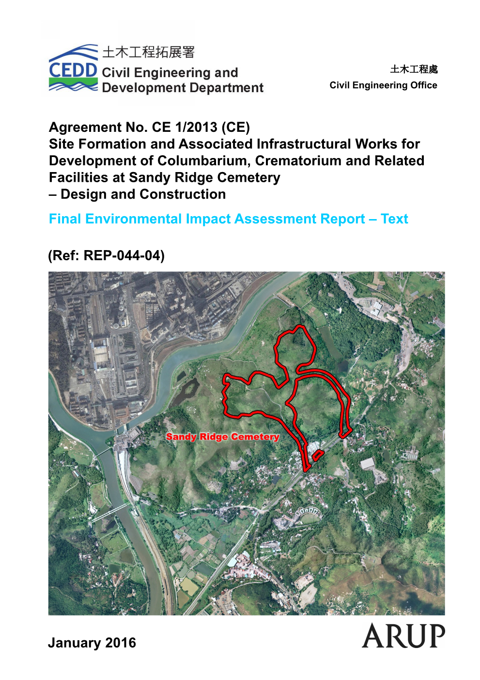
1.1
Project Background
1.1.1.1
As stipulated in the 2010-11 Policy Agenda, the Administration will identify suitable sites for columbarium
development across the territory
and conduct technical
feasibility studies of shortlisted sites to increase supply of columbarium. The Administration will continue to review the provision of cemeteries, columbaria and
crematoria facilities and strive to provide more facilities to meet future demand.
1.1.1.2
With a growing and aging population in Hong
Kong, the number of deaths and the corresponding number of cremations have been
rising gradually every year, resulting in an increasing public demand for
columbarium facilities. Based on past data, the average annual numbers of deaths
and cremations in the next 20 years (i.e. from 2014
to 2033) are estimated to be about 54,000 and 51,000 respectively. Upon completion
of the latest reprovisioning projects
of Wo Hop Shek and Cape Collinson
Crematoria by late 2015, the total annual capacity of all public cremators will be increased from
38,000 sessions to 53,000 sessions. This will sufficiently
meet the cremation
demand up to around 2024. There is genuine
need to construct new crematoria at Sandy
Ridge Cemetery to address the demand beyond 2024. As
for columbarium, the supply of public niches is uncertain
after the completion of the Diamond Hill Columbarium extension, the new
public columbarium at Kiu Tau Road in the Wo Hop Shek Cemetery and the Cheung
Chau Cemetery extension in 2012 and 2013 providing about 1,500, 43,700 and
1,000 respectively of which allocation of niches would be largely completed in
mid 2015. Hence, there is a need to construct new columbarium facilities.
1.1.1.3
The Sandy Ridge Cemetery is one of the 24 potential sites for columbarium development in 18 districts announced
in three batches in July 2010, December 2010
and April 2011 respectively. Furthermore, it is planned to provide synergistic
one-stop services at the Sandy Ridge Cemetery by including
at least a funeral parlour and a visitor
service centre so as to maximise the convenience to the public. It is hoped that this
project will set a new benchmark for the public C&C facilities and services in terms of its functional one-stop services, state-of-the art design incorporating artistic elements of aesthetic appeal where appropriate, greening
and landscaping, user-friendly access for visitors and serene
surrounding environment. It
will be a place
where those lost loved ones can rest in eternal peace in a dignified manner, and
where family members, relatives and friends can part with and mourn for their loved ones in reasonable
privacy, and where visitors
will find it pleasant to stay to admire
the landscape and the greenery.
1.1.1.4
The Sandy Ridge Cemetery is under the management of Food and Environmental Hygiene
Department (FEHD) and is located between Lo Wu Boundary Control
Point (BCP) and Man Kam To BCP. To the north across Shenzhen River are the
residential and commercial areas of Shenzhen. To the east are Man Kam To BCP
and San Uk Ling (Indigenous Village). To the south are rural settlements of Sha
Ling and existing Government, Institution or Community facilities including the
Border District Police Headquarters. To the west are MTR Lo Wu Station, Lo Wu
BCP and the hilly terrain of Tai Shek Mo west of the Ng Tung River.
1.1.1.5
In March 2011, Food and Hygiene Bureau (FHB) engaged Civil Engineering and
Development Department (CEDD) to conduct a feasibility study on the site
formation and associated infrastructural works for the development of
columbarium facilities providing at least 200,000 inches, a crematorium with 10
cremators, a funeral parlour with 30 service halls and a visitor service centre
at Sandy Ridge Cemetery under Agreement No. CE 32/2010 (CE). The feasibility
study was substantially completed in September 2012.
1.1.1.6
It has been identified in the feasibility study that some elements in
the Project are designated projects under Schedule 2 of the Environmental
Impact Assessment Ordinance (EIAO) and require EPs prior to their construction
and operation. The Project Profile (No. PP-482/2013) was submitted by CEDD to Environmental Protection Department
(EPD)
for an Environmental Impact Assessment (EIA) Study Brief under Section 5(1)(a)
of the EIAO
on 18 February 2013. The EIA Study Brief (EIA Study Brief No.: ESB-257/2013)
was formally issued by EPD on 26 March 2013.
1.1.1.7
On 28 June 2013, CEDD
commissioned Ove Arup & Partners Hong Kong Limited (Arup) under Agreement No. CE 1/2013 to
provide consultancy services in respect of Site Formation and Associated
Infrastructural Works for Development of Columbarium, Crematorium and Related
Facilities at Sandy Ridge Cemetery – Design and Construction (The Assignment).
This consultancy also includes the compilation of an EIA Report to fulfil the relevant
legislative requirements.
1.1.1.8
Subsequent to the issue of the EIA Study Brief No. ESB-257/2013 dated
March 2013, the traffic and transport arrangement has been reviewed. In
addition to the road widening works at Choi Yuen Road, road widening works
along Lin Ma Hang Road are also required within the adjacent areas at Sandy
Ridge. Hence, given all these changes, a new Project Profile (PP-503/2014) was submitted to EPD on 13 March
2014. The EIA Study Brief No. 271/2014 was issued by EPD on 23 April 2014.
1.2
Site
Location and History
1.2.1.1
Sandy Ridge Cemetery is located inside the Frontier Closed Area at the
northern boundary of the New Territories. It is bounded by Man Kam To Road to the
east and south, Lo Wu Village, MTR Lo Wu Station and Lo Wu Station Road to the
west and Shenzhen River to the North.
1.2.1.2
There are two public cemeteries situated in Sandy Ridge, namely Sandy
Ridge Cemetery and Sandy Ridge Urn Cemetery. They were both constructed in 1949
and opened to the public in 1950. At that time, the Sandy Ridge Cemetery
comprised of 4 coffin sections: Sha Ling (general), Roman Catholic Church,
Little Sister of the Poor and Tung Wah; while the Sandy Ridge Urn Cemetery
consisted of nine sections: Sha Ling (general), Tung Wah, Chaozhou, Enping,
Zhongshan, Heshan, Xinhui, Zengcheng and Fujin. All of the above were managed
by private sectors except for Sha Ling (general).
1.2.1.3
Due to the shortage of land resulting from post-war immigration, the Hong
Kong Government aimed to ‘concentrate as many burials as possible in the public
cemetery at Wo Hop Shek and the urn cemetery at Sandy Ridge’ as a general
burial policy. In order to limit funerary land use, the requirement of
exhumation of all coffin burials after six years in public cemeteries was part
of government policy on cemeteries pre-1970. In addition, the practice of
exhumation was further encouraged in the renewed burial policies introduced in
1970 and 1976.
Some sections in the Sandy Ridge cemeteries were established to accommodate
graves relocated from cemeteries that had ceased operation as a result of urban
development and burial policy.
1.2.1.4
Sandy Ridge Cemetery is also a final home for unclaimed human remains. The
unclaimed graves from various cemeteries ceased operation, such as Shek O
Cemetery, Kai Lung Wan East Cemetery, New Stanley Cemetery, New Kowloon
Cemetery No.7 and Sham Wan Cemetery were relocated to Sandy Ridge Cemetery
since its opening in 1950.
1.2.1.5
Sandy Ridge Cemetery has remained its use as
cemetery since its establishment in 1949. Apart from the cemetery, the area
comprises of undeveloped terrain with vegetation coverage. There are some
indigenous villages and rural settlements scattered near the cemetery.
1.3
The Project
1.3.1.1
As described in the EIA Study Brief (ESB-271/2014), the Project
comprises site formation and infrastructural works for the development of
C&C facilities at Sandy Ridge Cemetery. The Project
comprises:
·
Site
formation and associated works of
about 10 hectares of land including landscaping, geotechnical, drainage and sewerage works, waterworks, and other utilities services for development of C&C facilities at the Sandy Ridge Cemetery;
·
Road works
including access road, tunnel and viaducts within Sandy Ridge Cemetery;
·
Pedestrian walkway between MTR Lo Wu Station and
proposed
columbarium;
·
Widening
the eastbound of Choi Yuen Road near MTR Sheung Shui Station from 1-lane to
2-lane carriageway (widening by about 3m) for about 400m length; and
·
Widening a section of Lin Ma Hang Road (about 1.4km
in length) from 6.5m to 7.3m.
1.3.1.2
However, according to the
latest development, the construction of a pedestrian walkway between MTR Lo Wu
Station and columbarium facilities at the Sandy Ridge Cemetery and associated
works including a mini concourse and modification works at MTR Lo Wu Station
and widening the eastbound of Choi Yuen Road near MTR Sheung Shui Station are
no longer required. In addition, it is proposed to have off-site pick-up /
drop-off points for shuttle buses at MTR Kwu Tung Station, MTR Fanling Station,
existing Sheung Shui Landmark North Public Transport Interchange (PTI) and layby
at Pak Wo Road near Flora Plaza. All these off-site pick-up / drop-off areas
would be within existing highway corridors. No excavation works would be
required and only road furnishing would be conducted. For MTR Kwu Tung Station
(including the PTI and shuttle bus services area), it will be constructed under
the Planning and Development Study on North East New Territories
(NENT) Contract and will be available by 2026. In addition, and a
barging point at Siu Lam, Lok On Pai, currently used by the Express Rail Link
project would also be required.
1.3.1.3
The location plans for the proposed development are shown
in Figures
1.1 and 1.2. The plan for the
proposed land
platform for the C&C facilities at Sandy Ridge Cemetery is shown in Figure
1.1. The plan for proposed road widening work along Lin Ma Hang Road and the
barging point at Siu Lam are shown in Figures 1.2 and 1.3 respectively.
1.3.1.4
More detailed description of the C&C facilities at Sandy Ridge
Cemetery and Lin Ma Hang Road is given in Chapter
2. It should be noted that the Crematorium
is a separate Schedule 2 designated project and hence the respective project
proponent would conduct a separate EIA Report for submission under the EIAO.
The site formation work for the crematorium would however be included in this
EIA Study.
1.3.1.5
The barging point is
located off-site along Tsing Fat Street in Tuen Mun. In order to reduce the
impact on road traffic, surplus inert construction and demolition (C&D)
materials from the construction of the C&C facilities at Sandy Ridge
Cemetery and Lin Ma Hang Road will be stored at a temporary stockpile area
on-site. The surplus inert C&D materials will be transported to the designated
barging point facility in Tuen Mun by lorries, and then transported by barges for
the reuse of other concurrent projects. The maximum number of barge movement is 2 round trips
per day. The current location is an existing barging
point used by the Express Rail Link project according to the approved EIA
report for Hong Kong Section of Guangzhou-Shenzhen-Hong Kong Express Rail Link
(AEIAR-143/2009). Minor construction works for the tipping halls and new ramps are
required. No maintenance dredging is required and no night-time operation is
anticipated.
1.4
EIA Study
Brief
1.4.1.1
In accordance with the
requirements of Section 5(1) of the EIAO, a project profile (no. PP-503/2014)
for the Project was submitted to the Director of Environmental Protection (DEP)
for application for an EIA Study Brief on 13 March 2014. Pursuant to Section
5(7)(a) of the EIAO, the DEP issued a Study Brief (No.: ESB-271/2014 dated 23 April
2014) for the EIA study.
1.4.1.2
The purpose of this EIA
study is to provide information on the nature and extent of environmental
impacts arising from the construction and operation of the Project and related
activities that take place concurrently. This information will contribute to
decisions by the Director on:
·
The acceptability of any
adverse environmental consequences that are likely to arise as a result of the
Project;
·
The conditions and requirements
for the design, construction and operation of the Project to mitigate against
adverse environmental consequences; and
·
The acceptability of residual
impacts after the proposed mitigation measures is implemented.
1.5
Designated
Projects
1.5.1.1
The Project comprises the following which are
classified as Designated Projects (DPs) as per Schedule 2, Part I of the EIAO:
·
Item A.8 – A road or railway
bridge more than 100m in length between abutments; and
·
Item I.1(b)(vii) – A drainage
channel or river training and diversion works which discharges or discharge
into an area which is less than 300m from the nearest boundary of an existing
or planned conservation area.
1.5.1.2
One of the new road sections leading from Man
Kam To Road up
to the platform of the Project comprises of a viaduct section of
approximately 300m long. Both ends of
the viaduct would need to be in a form as abutments. Since the length between the abutments is
more than 100m, it will be a DP under Item A.8 of
Schedule 2, Part I of EIAO.
1.5.1.3
The Conservation Area (CA) at Yuen Leng Chai is located approximately
45m north west of the proposed Project and there is a vertical difference
between the proposed platform and the CA.
Hence, a portion of the surface run-off from the proposed platform will
be drained into this CA. Hence, it will be a DP under Item I.1(b)(vii) of Schedule 2, Part 1
of EIAO.
1.5.1.4
The locations of the above DP
under the
Project are shown in Figure 1.4.
1.6
Objectives
of the EIA Study
1.6.1.1
According to Section 1.5 of
the EIA Study Brief (No.: ESB-271/2014), this EIA study is to provide
information on the nature and extent of environmental impacts arising from the
construction and operation of the Project and related activities that take
place concurrently. This information will contribute to decisions by the
Director of Environmental Protection on:
·
The acceptability of any adverse
environmental consequences that are likely to arise as a result of the Project;
·
The conditions and requirements
for the design, construction and operation of the Project to mitigate against
adverse environmental consequences; and
·
The
acceptability of residual impacts after the proposed mitigation measures is
implemented.
1.6.1.2
The objectives of the EIA
study are as follows:
·
To describe the Project and
associated works together with the requirements and environmental benefits for
carrying out the Project;
·
To identify and describe
elements of community and environment likely to be affected by the Project
and/or likely to cause adverse impacts to the Project, including natural and
man-made environment and the associated environmental constraints;
·
To
identify and quantify emission sources (including air quality, noise, water
quality and waste, etc. as appropriate) and determine the significance of
impacts on sensitive receivers and potential affected uses;
·
To
identify and quantify any potential ecological and fisheries impacts arising
from the construction and operation of the Project and to propose measures to
mitigate these impacts;
·
To
identify any negative impacts on sites of cultural heritage and to propose
measures to mitigate these impacts;
·
To
identify any potential landscape and visual impacts and to propose measures to
mitigate these impacts;
·
To propose
the provision of infrastructure or mitigation measures to minimise pollution,
environmental disturbance and nuisance during construction and operation of
Project;
·
To
investigate the feasibility, practicability, effectiveness and implications of
the proposed mitigation measures;
·
To
identify, predict and evaluate the residual environmental impacts (i.e. after
practicable mitigation) and the cumulative effects expected to arise during the
construction and operation phases of the Project in relation to the sensitive
receivers and potential affected uses;
·
To
identify, assess and specify methods, measures and standards, to be included in
the detailed design, construction and operation of the Project which are
necessary to mitigate these residual environmental impacts and cumulative
effects and reduce them to acceptable levels;
·
To
investigate the extent of the secondary environmental impacts that may arise
from the proposed mitigation measures and to identify constraints associated
with the mitigation measures recommended in the EIA study, as well as the
provision of any necessary modification;
·
To design
and specify environmental monitoring and audit requirements to check the
effective implementation of the recommended environmental protection and
pollution control measures; and
·
To
identify any additional studies necessary to implement the mitigation measures
or monitoring and proposals recommended in the EIA report.
1.7
Need for
the Project
1.7.1.1
As discussed in Section 1.1, with a growing and aging population in Hong
Kong, the number of deaths and the corresponding number of cremations have been
rising gradually every year, resulting in an increasing public demand for
columbarium facilities. Based on past data, the average annual numbers of
deaths and cremations in the next 20 years (i.e. from 2014
to 2033) are estimated to be about 54,000 and 51,000 respectively. Upon completion
of the latest reprovisioning projects
of Wo Hop Shek and Cape Collinson
Crematoria by late 2015, the total annual capacity of all public cremators will be increased from
38,000 sessions to 53,000 sessions. This will sufficiently
meet the cremation
demand up to around 2024. There is genuine
need to construct new crematoria at Sandy
Ridge Cemetery to address the demand beyond 2024. As
for columbarium, the supply of public niches is uncertain
after the completion of the Diamond Hill Columbarium extension, the new
public columbarium at Kiu Tau Road in the Wo Hop Shek Cemetery and the Cheung
Chau Cemetery extension in 2012 and 2013 providing about 1,500, 43,700 and
1,000 respectively of which allocation of niches would be largely completed in
mid 2015. Hence, there is a need to construct new columbarium facilities.
1.8
Environmental Benefits of the Project
1.8.1.1
The environmental benefits
of the Project are summarised below:
1.8.2
Existing Visitors
1.8.2.1
All the
existing users and visitors to the cemetery and the graves would need to rely
on the existing Sha Ling Road to access Sandy Ridge. During the festive days in
particular, they are required to make their own transport arrangement to Man
Kam To Road. From there, most of the visitors would need to either walk up the
existing Sha Ling Road or take franchised mini buses to access Sandy Ridge
Cemetery. However, the existing Sha Ling Road is only 6m wide without a proper
pedestrian walkway and the gradient at some sections are relatively steeper. On
the other hand, the capacity of the franchised mini buses is limited. Under
such circumstance, a small portion of users would drop off at MTR Lo Wu Station
and use an existing footpath to reach Sandy Ridge area. This existing footpath
is only 1.5m wide and is not paved, which would be inconvenient especially during
rainy days.
1.8.2.2
With
this project in place, the Sha Ling Road will be upgraded to a 7.3m wide with 2
lanes and pedestrian walkway, and the gradients along the road have also been
optimized. Besides, additional public transport will be provided to allow for a
more convenient access from Man Kam To Road up to the future platform. All
these improvements in infrastructure would benefit the existing users and
visitors to provide an easier and more convenient access. This improvement in
accessibility may also attract some of the visitors to consider visiting Sandy
Ridge Cemetery at alternative days other than festive days. This would help alleviating
the traffic demand during festive days and hence the associated environmental
impacts.
1.8.2.3
As
discussed in Section 1.1, the
proposed development would integrate columbarium, crematorium and other related
facilities at one location. This arrangement would definitely minimise
generation of any unnecessary off-site traffic (e.g. From Kwai Chung
Crematorium to Hong Kong Cemetery) that would otherwise need to travel between
columbarium and crematorium. Hence, the off-site traffic would be
minimised and hence any nuisance that may have caused on the communities in the
vicinity of the access roads would also be reduced as much as practicable.
1.8.3
Existing Sewerage System
1.8.3.1
In
addition, there is no existing sewerage system for Sandy Ridge Cemetery. With
the Project in place, the disposal of waste water from the visitors will be
collected properly through the proposed sewerage system. This would also help
to improve the existing conditions.
1.8.4
Green Transportation
1.8.4.1
The other environmental
benefit that would be brought about by the Project is from the arrangement for
off-site pick-up / drop-off locations for shuttle buses. As discussed in Section 1.3, shuttle buses would be
arranged at a number of MTR Stations at MTR Kwu Tung Station, MTR Fanling
Station, existing Sheung Shui Landmark North Public Transport Interchange (PTI)
and layby at Pak Wo Road near Flora Plaza. Instead of making their own
arrangement (such as private cars, public transport to existing shuttle bus
location at Sheung Shui), all the way from urban area to Man Kam To Road or
areas in the vicinity, the future visitors could choose to use the shuttle bus
route that is more convenient to them. Obviously, this convenience of using shuttle
buses would encourage all the visitors to use public transport during festive
days and hence help reducing vehicular emissions which would in turn be
beneficial for air quality.
1.8.5
Existing Communities along Lin
Ma Hang Road
1.8.5.1
The existing Lin Ma Hang
Road is only 6m wide in some sections and with footpath of inconsistent width.
As discussed in Section 1.3, part of
the Project proposal is to widen the existing Lin Ma Hang Road to 7.3m up to
standard requirement as given in Hong Kong Planning Standards and Guidelines
(HKPSG) and a 2m wide of footpath would be provided. The footpath would be
designed with appropriate landscape features such as tree planting, and would enhance
aesthetic appeal of the surrounding environment, and provide a more convenient
means of vehicular and pedestrian access for the local community.
1.9
Scenarios “With” and “Without” Project
1.9.1.1
As discussed in Sections 1.1 and
1.7, if the Project does not proceed, columbarium
facilities may not be adequate to meet future demand. Alternative locations in other areas such as urban area
may be required for columbarium facilities which may induce more environmental
impacts (i.e. noise, air, visual, etc.) to the nearby communities.
1.9.1.2
Nevertheless, the implementation of the Project would inevitably introduce some
temporary environmental impacts during construction phase. This would require
some mitigation measures to alleviate the impacts. During the operational
phase, some mitigation measures for noise, landscape and ecology would also be
required to alleviate the associated impacts. Sections 4 – 12 present
the environmental assessments with respect to various environmental aspects and
mitigation measures are also identified and recommended if necessary.
1.10
Concurrent Projects
1.10.1.1
The potentials impacts of
concurrent projects during the construction and operation of the proposed
Project are identified as follows. Figure 1.5 shows the locations and
alignments of these concurrent projects.
1.10.1.2
Most
of the concurrent projects are located at a distance far away (i.e. >500m)
from the Sandy Ridge Project boundary and therefore will not cause significant adverse
cumulative landscape and visual impact.
1.10.1.3
Only
the Widening of Lin Ma Hang Road (eastern and western sections) is adjacent to
the Project. However, the demarcation of the two projects are clear and will
not cause cumulative landscape and visual impact. The landscape and visual
impact of each project would be assessed in other individual EIA and environmental
review studies.
1.10.2
Operation of the Crematorium at
Sandy Ridge
1.10.2.1
During operational phase,
as the crematorium is a Designated Project under Item N.4 of Schedule 2 of
TM-EIAO, a separate EIA study would be conducted to fulfil all the statutory
requirements and procedures under the EIAO and thus the fixed noise impact,
chimney emission and odour will be excluded from this Assignment. However,
vehicular emission and road traffic noise from its induced traffic is
anticipated and therefore have been included in the assessment.
1.10.2.2
As discussed in Section 1.1, the crematorium at Sandy
Ridge consists of 10
cremators, a funeral parlour with 30 service halls and a visitor service
centre.
1.10.2.3 The construction of crematorium at Sandy Ridge will be commenced
after completion of site formation and associated infrastructural works of the
Project. Cumulative dust and noise during construction phase is therefore not
anticipated.
1.10.3
Development of Organic Waste
Treatment Facilities, Phase 2 (OWTF)
1.10.3.1 According to the approved EIA Study “Development of Organic Waste
Treatment Facilities, Phase 2” (AEIAR-180/2013), the proposed OWTF is located
at Sha Ling and the plant will process around 300 tonnes of organic waste per
day to produce biogas and soil enhancement products (e.g. soil conditioner /
compost).
1.10.3.2
The proposed OWTF Phase 2
construction work will be commenced in 2016 / 2017 and is anticipated to be
completed in 2018 / 2019. As the separation distance between OWTF Phase 2 and
the Project is about 200m, cumulative dust and noise during construction phase
are anticipated and therefore would be included in the assessment. However, as
OWTF Phase 2 would not induce significant amount of traffic using Man Kam To
Road, vehicular emission and road traffic noise during operational phase is not
anticipated.
1.10.4
Police Facilities in Kong Nga
Po
1.10.4.1 In October 2012, CEDD commenced an engineering
feasibility study for Kong Nga Po. The objective of the Study is to ascertain
the feasibility of developing the Kong Nga Po Site for residential use upon its
release from the Frontier Closed Area (FCA). Meanwhile, an alternative land use
option for co-locating various police facilities in Northern District to one
centralised location in Kong Nga Po has been proposed. CEDD
carried out a Preliminary Feasibility Assessment for co-locating police
facilities in Kong Kga Po in July 2013. The project consists of relocation of
existing police facilities, construction of new police facilities and road
improvement works for Kong Nga Po Road, which is anticipated to be completed
for operation by 2022. As the project is located outside 500m from the Project,
cumulative dust and noise during construction phase is not anticipated.
However, vehicular emission and road traffic noise from its induced traffic is
anticipated and therefore would be included in the assessment.
1.10.5
Widening of Lin Ma Hang Road
1.10.5.1
According to the
ESB-264/2013, the eastern section of Lin Ma Hang Road connecting Tsung Yuen Ha
and Lin Ma Hang is widened to cater for the anticipated traffic growth of Lin
Ma Hang Road and provide a safer and more efficient road network for local
villagers and visitors. The proposed Lin Ma Hang Road widening is a DP under
the EIAO. In addition, a part of western section of Lin Ma Hang Road connecting
River Ganges and Ping Che Road is widened and an environmental review will be
conducted. As the western section is located next to the Project, cumulative
dust and noise during construction phase is anticipated and therefore would be
included in the assessment. In addition, the vehicular emission and road
traffic noise from its induced traffic is also anticipated and therefore would
be included in the assessment.
1.10.6
Liantang / Heung Yuen Wai
Boundary Control Point and Associated Works
1.10.6.1 According to the approved EIA Study “Liantang / Heung Yuen Wai
Boundary Control Point and Associated Works” (AEIAR-161/2011), the proposed BCP
and associated works is a DP under the EIAO. The proposed work is located at
the boundary with Shenzhen near the existing Chuk Yuen Village and the
connecting road alignment consists of six main sections located at Lin Ma Hang
Road, Ping Yeung to Wo Keng Shan, Cheung Shan, Sha Tau Kok Road, Loi Tung and
Fanling.
1.10.6.2
The proposed BCP and
associated works has commenced in mid 2013 and is anticipated to be completed in
mid 2018. As the proposed BCP and associated works is located outside 500m from
the Project, cumulative dust and noise during construction phase is not
anticipated. However, vehicular emission and road traffic noise from its
induced traffic is anticipated and therefore would be included in the
assessment.
1.10.7
Development of Lok Ma Chau Loop
(LMC Loop)
1.10.7.1 According to the approved EIA Study “Development of Lok Ma Chau Loop”
(AEIAR-176/2013), the proposed LMC Loop (about 87.7ha) will be developed with higher
education as the leading land use, complemented by high-tech research and
development, cultural & creative industries. The associated infrastructure
such as connecting roads, service reservoir, water mains, etc has also been proposed.
The proposed LMC Loop and the associated infrastructure include seven DPs under
the EIAO.
1.10.7.2
The advanced works of the proposed
LMC Loop will tentatively commence in mid 2016, site formation in 2018 and
completed in early 2027 for final phasing. As the proposed LMC Loop is located
outside 2.5km from the Project, cumulative dust and noise during construction
phase is not anticipated. However, vehicular emission and road traffic noise
from its induced traffic is anticipated and therefore would be included in the
assessment.
1.10.8
North East New Territories New
Development Area (NENT NDA)
1.10.8.1 According to the approved EIA Study “North East New Territories New
Development Areas” (AEIAR-175/2013), the proposed NENT NDA is one of the ten
major infrastructure projects in the 2007 – 2008 Policy Address to address
long-term housing demand and job opportunities. The layout plan is to
accommodate about 174,900 population with the associated infrastructure such as
road works, sewage treatment works, drainage channel, wholesale market, etc.
The total area of NENT NDA is about 614ha located at Kwu Tung North and Fanling
North and the NENT NDA includes thirteen DPs under the EIAO.
1.10.8.2
Kwu Tung North is located
to the west of Sheung Shui and is generally bounded by Shek Sheung River to the
east, Castle Peak Road and Fanling Highway (New Territories Circular Road) to
the south, Pak Shek Au and Tit Hang villages to the west and the present Closed
Area boundary to the north. The NDA has an area of some 450 ha and is proposed
to accommodate a population of about 101,600 people on full development.
1.10.8.3
Fanling North is located
immediately to the north-east of the established Fanling/Sheung Shui New Town
and is bounded by Upper Ng Tung River to the north and east, Sha Tau Kok Road
to the south, and Ma Sik Road and Tin Ping Road to the south-west. The NDA has
an area of around 164ha and is proposed to accommodate a population of about
73,300 people on full development.
1.10.8.4
The proposed NENT NDA will
be constructed in late 2017 and completed in early 2027 for final phasing. According
to the approved EIA study “North East New Territories New Development Areas”
(NENT NDA) (AEIAR-175/2013), the construction phase
results showed that the 1-hr TSP concentration within the overlapped assessment
area between the planned NENT NDA and the Project is lower than 200μg/m3
(or lower than 127μg/m3 excluding background TSP) and is
complying with the 500μg/m3 TSP criteria. The current Project
design only requires limited utility construction works within the overlapped
area and the maximum predicted 1-hr TSP concentration is only 226μg/m3
(including background). Given the ample margin between
the TSP criteria and the assessment results (353 μg/m3) and the
small scale of utility construction activities in the overlapping area, adverse
cumulative dust impact is not anticipated. In addition, cumulative construction
noise is not anticipated as NENT NDA is outside 300m from the utilities
construction. However, vehicular emission and road traffic noise from its
induced traffic is anticipated and therefore would be included in the
assessment.
1.10.9
Widening of Tolo / Fanling
Highway between Island House Interchange and Fanling
1.10.9.1
The proposed widening of
Tolo / Fanling Highway between Island House Interchange and Fanling comprises
·
Widening of a section of
Fanling Highway of approximately 3km long between Tai Hang and Wo Hop Shek
Interchange from dual three-lane to dual four lane carriage
·
Widening of the southbound slip
road at Wo Hop Shek Interchange.
1.10.9.2
The tentative completion
date is from Year 2015 and Year 2018 but is still under review by Highways
Department. As the widening work is located outside 4km from the Project,
cumulative dust and noise during construction phase is not anticipated.
However, vehicular emission and road traffic noise from its induced traffic is
anticipated and therefore would be included in the assessment.