12 Impact on Cultural Heritage
12.1.1 This section presents the assessment for cultural heritage impacts that may arise from the construction and operation of the proposed Hung Shui Kiu New Development Area (HSK NDA) (herein referred to as the “Project”) as per the Revised Recommended Outline Development Plan (RODP).
12.1.2 Details of the key project elements proposed within the Revised RODP (Figure 2.2) are described in Chapter 2.
12.2 Environmental Legislation, Policies, Plans, Standards and Criteria
12.2.1 Legislation, standards and guidelines relevant to the consideration of cultural heritage under this EIA include the following:
· Environmental Impact Assessment Ordinance EIAO (Cap.499) and Technical Memorandum (EIAO-TM) - the EIAO stipulates that consideration must be given to issues associated with built heritage and archaeology as part of the EIA process. Schedule 1 Interpretation of the EIAO defines “Sites of Cultural Heritage” as “an antiquity or monument, whether being a place, building, site or structure or a relic, as defined in the Antiquities and Monuments Ordinance and any place, building, site, or structure or a relic identified by the Antiquities and Monuments Office (AMO) to be of archaeological, historical or paleontological significance”;
The EIAO-TM identifies a general presumption in the favor of the protection and conservation of all sites of cultural heritage and requires impacts upon sites of cultural heritage to be 'kept to the absolute minimum'. Annex 10 and 19 of the EIAO-TM outline criteria for evaluating the impacts on sites of cultural heritage and guidelines for impact assessment, respectively;
· Guidance Note on Assessment of Impact on Sites of Culture Heritage in Environmental Impact Assessment Studies - the Guidance Note assists the understanding of the requirements of the EIAO-TM in assessing impact on sites of cultural heritage in EIA studies;
· Antiquities and Monuments Ordinance (A&MO) (Cap.53) - the Ordinance provides the statutory framework for the protection of Declared Monuments and preservation of objects of historical, archaeological and paleontological interest. The Ordinance contains the statutory procedures for the Declaration of Monuments. Under the Ordinance, a “monument” means a place, building, site or structure which is declared to be a monument, historical building or archaeological or paleontological site;
· Hong Kong Planning Standards and Guidelines (HKPSG) - Chapter 10 of HKPSG covers planning considerations relevant to conservation. It also details the principles of conservation, the conservation of natural landscape and habitats, historic buildings and sites of archaeological interest, and addresses the issue of enforcement. The HKPSG appendices list the legislation and administrative controls for conservation, other conservation related measures in Hong Kong, and Government departments involved in conservation;
· Guidelines for Cultural Heritage Impact Assessment (GCHIA) - the Guidelines outline the technical requirements for conducting cultural heritage impact assessment. The guidelines put preservation in totality as the first priority. Mitigation measures should be proposed in cases with identified impacts and if this is not feasible due to site constraints or other factors, full justification must be provided.
12.3 Assessment Approach and Methodology
12.3.1 In accordance with Clause 3.4.13.2 of the EIA Study Brief (No. ESB-291/2015), the assessment area covers an area within 100 m from the boundary of the proposed Project and associated works (refer to Figures 12.1 and 12.2). The following presents the assessment approach for Archaeology and Built Heritage followed for this EIA Report.
Archaeology
12.3.2 A desktop literature review was conducted to assess the potential existence of archaeological remains within the assessment area. The following information has been considered in this EIA:
· AMO’s List of Sites of Archaeological Interest;
· Lists and archives kept in the Reference Library of AMO;
· Publications on local historical, architectural, anthropological, archaeological and other cultural studies, such as, Journals of the Royal Asiatic Society (Hong Kong Branch), Journals of the Hong Kong Archaeological Society, AMO Monograph Series and so forth;
· Other unpublished papers, records, archival and historical documents through public libraries, archives, and the tertiary institutions, such as the Hong Kong Collection and libraries of the Department of Architecture of the University of Hong Kong and the Chinese University of Hong Kong, Public Records Office, photographic library of the Information Services Department and so forth;
· Any other unpublished archaeological investigation and excavation reports kept by AMO;
· Relevant information from AMO’s website;
· Historical documents in the Public Records Office, the Land Registry, District Lands Office, District Office and the Hong Kong Museum of History and so forth;
· Cartographic and pictorial documents. Old and recent maps and aerial photos searched in the Map and Aerial Photo Library of the Lands Department;
· Existing geological and topographic information; and
· Previous EIA study reports, archaeological reports and related studies.
12.3.3 An Archaeological Field Survey (AFS) was undertaken and completed in March 2015. The AFS report was approved by AMO (Appendix 12.2). The objectives of the AFS were:
a) to review the findings of existing available information regarding the archaeological remains (literature review);
b)
to compile a
comprehensive inventory of known archaeological sites and archaeological
potential area(s);
c)
to assess known archaeological
sites within the assessment area which will be directly impacted by the
developments and infrastructure of the NDA;
d)
to assess the
archaeological potential of areas near known archaeological sites;
e)
to identify any unknown
archaeological site/archaeological potential areas affected by the developments
and infrastructure of the NDA;
f)
to appraise the
cultural heritage value of archaeological remains, deposit and structures, as
well as to establish the archaeological potential that is likely to be affected
by the developments and infrastructure of the NDA;
g)
to provide baseline
information and evaluation of the conditions of the archaeological remains for
assessment of potential impacts caused by the developments and infrastructure
of the NDA, and recommendation of mitigation measures for such impacts; and
h)
to submit “Draft and
Final Archaeological Survey Report and Executive Summary Reports” containing
all the data and the results of the Survey.
Built Heritage
12.3.4 Features which fall within the scope of the baseline study of built heritage include:
· all declared monuments;
· all proposed monuments;
· all buildings/ structures/ sites graded or proposed to be graded by the Antiquities Advisory Board (AAB);
· Government historic sites identified by AMO;
· buildings/ structures/ sites of high architectural / historical significance and interest which are not included above;
· cultural landscapes include places associated with historic event, activity, or person or exhibiting other cultural or aesthetic values, such as sacred religious sites, battlefields, a setting for buildings or structures of architectural or archaeological importance, historic field patterns, clan graves, old tracks, fung shui woodlands and ponds, etc. List of declared and proposed monuments protected by the Antiquities and Monuments Ordinance (Chapter 53);
12.3.5 In this assessment, the built features include village houses, ancestral halls, study halls, temples, churches, shrines, monasteries, village gates, wells, schools, historic walls, bridge stone tablets, government functional structures, shop houses and military structures. Their cultural significances were briefly assessed to establish the baseline condition for the identification of potential impacts arising from the proposed construction works and recommendations for the corresponding mitigation measures. With reference to the Charter for the Conservation of Places of Cultural Significance (1999) (The Burra Charter) issued by the International Council on Monuments and Sites (ICOMOS) of UNESCO, “cultural significance” means aesthetic, historic, scientific, social or spiritual value.
12.3.6 Cultural and historical landscapes assessed in this cultural heritage impact assessment include places associated with an historic event, activity, or person or exhibiting other cultural or aesthetic values, including:
· Sacred religious sites;
· Battlefields;
· A setting for buildings or structures of architectural or archaeological importance;
· Historic field patterns;
· Clan or historic graves, which are associated with historical figures of a community;
· Old tracks or footpaths;
· Assessment results of the 1,444 historic buildings with their existing and respective proposed grading, recently published by AMO; and
· Historical structures and buildings.
12.3.7 The following information was analyzed, collected and collated during the desktop literature review to determine the presence of historical occupation in the assessment area. This information was used to assess the potential existence of cultural heritage within the assessment area:
· Background information of heritage sites (including declared monuments, government historic sites, sites of archaeological interest and graded historic buildings identified by AMO) within and in close proximity to the assessment area found in available documents (e.g. AMO files, Public Records Office, map libraries, university and public libraries, published and unpublished government and non-government documents, cartographic and pictorial documents);
· Areas proposed for construction and operation-related activities and potential impacts induced by the Revised RODP; and
· Identification of previously recorded built heritage within the assessment area.
· Lists and archives kept in the Reference Library of AMO;
· Publications on local historical, architectural, anthropological, archaeological and other cultural studies, such as, Journals of the Royal Asiatic Society (Hong Kong Branch), Journals of the Hong Kong Archaeological Society, AMO Monograph Series and so forth;
· Other unpublished papers, records, archival and historical documents through public libraries, archives, and the tertiary institutions, such as the Hong Kong Collection and libraries of the Department of Architecture of the University of Hong Kong and the Chinese University of Hong Kong, Public Records Office, photographic library of the Information Services Department and so forth;
· Relevant information from AMO’s website;
· Historical documents in the Public Records Office, the Land Registry, District Lands Office, District Office and the Hong Kong Museum of History and so forth;
· Cartographic and pictorial documents. Old and recent maps and aerial photos searched in the Map and Aerial Photo Library of the Lands Department; and
· Previous EIA study reports and related studies.
12.3.8 Field survey performed between January and March 2015 included the following tasks:
· Recording of identified built heritage features;
· Interviews with local informants, residents and elders, when appropriate. The interviews aimed to gather information, such as cultural and historical background of the buildings and structures, as well as historical events associated with the built heritage features;
· Systematic documentation of recorded features including:
o 1:1000 scale maps showing the location and boundary of the cultural heritage resources; and
o Written descriptions of recorded features of historic buildings, e.g. age of the building or structure, details of architectural features, condition of the building or structure, past and present uses, architectural appraisal, notes on any modifications, direction faced and associations with historical or cultural events or individuals.
Geological Background
12.4.1 The Project is located on the west side of the Yuen Long Plain. To the west lies the Castle Peak range, which is over 300 m high. To the east lies the reclaimed Tin Shui Wai, which was once a shallow sea before the 1980s. To the north is the Shum Wan coast, which includes the Shenzhen River. To the south is the Tuen Mun River Valley.
12.4.2 The bedrock in this area is volcanic. Superficial geological deposits can be roughly divided into alluvial deposits (generally below 10 mPD), colluvial deposits (generally between +10 mPD and +20 mPD) and some bedrock outcrops (generally above +20 mPD). Only small brooks and streams flow to the north and east into the Tin Shui Wai Main Channel.
Historical Background
12.4.3 Clues of human occupation in Hong Kong region can be found in historical textual records such as Shiji (史記) and Hanshu (漢書) written in the first century BC to first century AD respectively. These records indicate that the Yue (越) ethnic groups (also called “Hundreds of Yue” (百越)) were scattered around South China. Such ethnic groups were comprised of different tribes bearing various surnames and can be differentiated from the Han ethnic group, who lived in Central China, based on their physical characteristics, language, and folklore.
12.4.4 As early as AD736, the Tunmen Zhen (屯門鎮), a military division of Tang dynasty (AD618-907) was set up along the coast of present day western New Territories and Shenzhen. The Division existed for five dynasties (AD907-960). During the Song dynasty (AD960-1279), military establishments and other civil settlements were likely to have been set up at the coastal areas near the present Hung Shui Kiu. Between 1573 and 1912, the Hong Kong region was subordinated to the Xinan (新安) County, and then Xinan was renamed to the Baoan (寶安) County in 1912.
Hung Shui Kiu Prior to the British Occupation
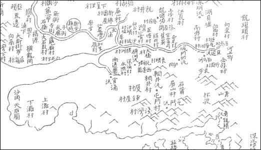
12.4.5 The 1864 map of Guangdong Gazetteer (廣東通志) indicated the existence of villages, Ha Tsuen (廈村), Chung Uk Tsuen (鍾屋村), Ping Shan Tsuen (屏山村), Shek Po (石莆 as present day 石埗) and Tuen Mun Tsuen (屯門村). The Hung Shui Kiu district was considered as the largest flatland in the New Territories on the 1864 map (Diagram 12.1 below). Back then, Ha Tsuen and Chung Uk Tsuen were agricultural area.
12.4.6 The Project area includes several villages and Buddhist temples. The earliest built heritage near to the assessment area is Ling To Monastery (靈渡寺). According to legend, the Buddhist monk Beidu (杯渡) passed by this region and stopped over at Ling To Mountain (靈渡山) and built the Ling To Monastery between AD424 and AD453. Ling To Monastery is over 50 m away from the assessment area boundary.
12.4.7 The significant settlements in Yuen Long can be traced back to the Song dynasty (AD960-1279)[1]. The Tangs settled in Kam Tin in the Northern Song dynasty. Their offspring branches moved to Ping Shan and Ha Tsuen later in the early to middle Ming dynasty[2]. Ha Tsuen Shi and Ping Shan Market were founded in the district in the mid-18th century due to intensive trading activities which continued to strive until Yuen Long Market was established.
Diagram 12.1 Hung Shui Kiu
Area and Tuen Mun North Area shown on the Map of Guangdong Gazetteer of 1864
12.4.8 In 1661, the Yuen Long residents were ordered to withdraw 50 li (里) inland (approximately 17 miles) from the coast to stop their collusion with Ming dynasty’s loyalist Zheng Chenggong (鄭成功) in Taiwan. The people were allowed to return to the land after 1669. After that, the Qing government started to encourage Hakka people to migrate to the area from other provinces including Jiangxi, Guangdong, and Fujian.
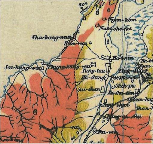
12.4.9 According to the 1903-1904 Hong Kong map (Diagram 12.2 below) the villages of Ngau Hom, Shek Pu, Tung Tau, San Wai, Sai Shan, Chung Uk Tsuen, and Nai Wai, etc. already existed. It can be seen from the map that Ha Tsuen and Ping Shan used to be located next to a narrow waterway which connected to Deep Bay before the 1950s. This waterway also reached Castle Peak Bay and served many commercial boats that transported goods between Yuen Long and Guangdong.
Diagram 12.2 Hung
Shui Kiu Area in 1903-1904 Map[3]
Archaeological Background
12.4.10 Heanley and Shellshear first identified an archaeological site in the Project area as site number 110 in the 1920s, and the site was re-identified by Schofield in the 1950s as “a hill half mile west of Ha Tsuen” (Peacock and Nixon 1986). This was the earliest record of archaeological finding in assessment area.
12.4.11 During the Deep Bay Link EIA Study (HyD, 2002), archaeological materials were identified near Ngau Hom Shek, Tin Sam Tsuen and Tsing Chuen Wai sites through a series of hand auger tests and test pit excavations. The locations fall within the assessment area of the current study. Prehistoric and Ming dynasty artefacts were identified on a beach site and a hill site at Ngau Hom Shek and some isolated prehistoric tools were found near Tin Sam Tsuen west (Figure 12.2). Some tile deposits from the Ming dynasty[4] were also discovered at the Tsing Chuen Wai site.
12.4.12 Details of other Sites of Archaeological Interest (SAIs) within the assessment area are presented in Section 12.5 below under the subheading “Site of Archaeological Interest”.
Sites of Archaeological Interest
12.5.1 A total of six known SAIs within the assessment area are recorded by AMO (as at Nov 2012[5]) (Table 12.1 refers). Tsing Tsuen Wai SAI (F7), which is 100.7m away from the Project Area, is also included in this Baseline Condition section. An impact assessment and mitigation measure recommendation has covered F1 to F7, but F7 is not considered within the assessment area.
Table
12.1 Existing
Sites of Archaeological Interest Located within the Assessment Area
|
ID No. |
Site |
Findings and Chronology |
Figure Number |
|
F1 |
Tseung Kong Wai SAI |
Old settlement, pottery sherds, Ming to Qing dynasties |
Figure 12.1 Figure 12.4 |
|
F2 |
Tung Tau Tsuen SAI |
Stone tools, celadon sherds, Late Neolithic Age, Song to Ming
dynasties |
Figure 12.1 Figure 12.4 |
|
F3 |
Hang Hau Tsuen SAI |
Pottery sherds, Song to Ming dynasties |
Figure 12.1 Figure 12.4 |
|
F4 |
Sha Kong Miu (North) SAI |
Pottery sherds, Late Neolithic to Bronze Age, Song to Ming dynasties |
Figure 12.1 Figure 12.4 |
|
F5 |
Ngau Hom Shek SAI |
Stone tools and ornaments, geometric ware sherds, celadon sherds, Late
Neolithic Age, Bronze Age, Song to Ming dynasties |
Figure 12.1 Figure 12.4 |
|
F6 |
Fu Tei Au SAI |
Stone tools and ceramics, postholes, house floors, ditches and burials
of Late Neolithic and Bronze Age |
Figure 12.1 Figure 12.4 |
|
F7 |
Tsing Tsuen Wai SAI |
Tile sherds, celadon and white-glazed stone ware pieces of Song
dynasty |
Figure 12.2 Figure 12.4 |
Tseung Kong Wai Site of Archaeological Interest (F1)
12.5.2 The Tseung Kong Wai SAI was first identified in the late 1990s. Thick layers of late historical remains dated to the Ming and Qing dynasties were found exposed on terrace surface. However, test pit excavation was unable to be undertaken on the site due to the objection by the land owner[6]. Consequently, the details of the site deposits remained unclear.
12.5.3 In 2002, an archaeological survey was carried out involving 12 auger tests, three face cuts and two test pits. The survey confirmed the existence of Ming-Qing remains, as well as a Neolithic cultural layer with cord-marked coarse pottery[7].
Tung Tau Tsuen Site of Archaeological Interest (F2)
12.5.4 Postholes and artefacts dated to Ming dynasty were discovered in 1998 during the Second Territory-Wide Archaeological Survey[8]. Nine test pits were excavated, and glazed stoneware sherds and stone implements dated to the late Ming to Qing dynasties were unearthed[9]. Ming deposit was further confirmed by the archaeological survey conducted in 2000[10].
12.5.5 In 2002, an archaeological investigation at Tung Tau Tsuen excavated three test pits. Archaeological features such as stone pavement and brick wall remains were exposed. According to the celadon sherds found associated with the features, the remains can be dated to the Song dynasty. Neolithic Age stone adze and celadon ware sherds of Song to Ming dynasties were found within Tung Tau Tsuen and a knoll behind Tung Tau Tsuen[11] [12].
12.5.6 Based on previous survey findings, Tung Tau Tsuen SAI is a village that can be traced back to the Ming and Qing period with possibility of Song origin.
Hang Hau Tsuen Site of Archaeological Interest (F3)
12.5.7 The Hang Hau Tsuen site was first discovered in 1982[13] and was re-investigated in 1983. A small quantity of coarse pottery sherds and pottery sherds with geometric patterns were unearthed from this site during the Second Territory-Wide Archaeological Survey in 1997[14]. However, the northern end of the present site boundary and the terrace north of Deep Bay Road, was later occupied by the Wing Jan Kindergarten. A survey undertaken at the site in 1999 only collected coarse pottery and geometric pottery sherds, and did not identify any archaeological deposits at the site[15].
12.5.8 During the archaeological survey conducted in 2001, while no prehistoric materials were identified inside Hang Hau Tsuen SAI, a few celadon sherds of Song dynasty, as well as blue and white porcelain sherds of Ming-Qing dynasty were identified on the sandbar and hill foot just outside the Hang Hau Tsuen SAI[16].
12.5.9 The vicinity of the Hang Hau Tsuen SAI certainly contains archaeological remains of both prehistoric and historical periods. However, the prehistoric deposits were very likely to have been disturbed or damaged. The preservation condition of remaining archaeological deposit has yet to be further investigated.
Sha Kong Miu (North) Site of Archaeological Interest (F4)
12.5.10 The Sha Kong Miu (North) SAI was first identified in the early 1980s. During the Second Territory-Wide Archaeological Survey in 1997, seven test pits were excavated at the site. The lower layer of the deposits yielded soft geometric pottery dated to the Late Neolithic period and the early Bronze Age, while the upper layer yielded hard geometric pottery with double-F patterns (夔紋) dated to the Bronze Age[17].
Ngau Hom Shek Site of Archaeological Interest (F5)
12.5.11 The Ngau Hom Shek SAI was first found in 1978 and has been re-investigated in the 1990s and the 2000s. The site can be differentiated into two components including hill site and coastal site.
12.5.12 Remains of the Neolithic period and Bronze Age were recorded at the hill site. A survey in 1994 unearthed geometric pottery with double-F patterns from four test pits. However, these early remains were associated with modern porcelain sherds in the same context[18]. Surveys were subsequently conducted on the hilly terrace in 1997[19], 1999[20] and 2001[21], prehistoric sherds were collected but underground deposits could not be confirmed.
12.5.13 The coastal site was identified during the 2001 survey mentioned above. Celadon sherds were unearthed from the auger holes on the beach.
12.5.14 In 2003, a rescue excavation was carried out on the beach area. Nine test pits of 5 m × 5 m were excavated. A vast amount of ceramic remains were unearthed from the excavation, including tens of thousands of prehistoric sherds weighing over 200 kg made up of around 2,500 sherds of historical period between Han and Song dynasties. However, all artefacts unearthed in this excavation were from secondary deposits[22].
12.5.15 Ngau Hom Shek SAI is a coastal-to-hill site with human activities from multiple periods spanning from the prehistoric to the historical time. However, the original deposits of this site have been severely disturbed and intact deposits have yet to be identified.
Fu Tei Au Site of Archaeological Interest (F6)
12.5.16 The Fu Tei Au site is located close to the Ngau Hom Shek site and shares the same topographic setting. In 1997 during the Second Territory-Wide Archaeological Survey, two test pits were excavated at the site, yielding stone implements and geometric pottery dating to the early Bronze Age[23]. During the re-investigation of the site in 1999, both Bronze Age remains and earlier Neolithic deposits were discovered from excavations of four test pits[24].
12.5.17 During the period of 2003 and 2004, the Hong Kong Archaeological Society (HKAS) conducted excavations in two seasons and opened up 13 test pits at the site. The excavation unearthed rich lithic and ceramic remains as well as archaeological features including pole holes, house floors, ditches and human burials. The identified deposits were dated to the Shang period or earlier in the Chinese chronology[25].
Tsing Chuen Wai Site of Archaeological Interest (F7)
12.5.18 The Tsing Chuen Wai site was identified during the surveys for the Deep Bay Link project in the early 2000s. Song celadon wares were collected at the site but the test pit excavation only confirmed deposits of the Ming dynasty[26].
12.5.19 The rescue excavation conducted at the Tsing Chuen Wai site in 2003, comprising 40 auger holes and five test pits, revealed deposit layers dated to the Song, Ming and Qing dynasties respectively. The artifacts unearthed from the excavation include over 4,000 tile sherds, which testified a residential settlement dating to the Song period in this district. The celadon and white-glaze stoneware pieces were probably made at kilns in Fujian and Jiangxi of mainland China[27].
12.5.20 The range of previous archaeological works at Tsing Chuen Wai is widely spread but the boundary of the Tsing Chuen Wai is set close tight to the test pit with rich Song ceramic remains. The areas outside the site boundary are now occupied by village houses.
Previous Archaeological Investigations
12.5.21 Archaeological site of Bronze Age (about 3,000 years ago) and Tang dynasty (AD 618-907) were found in Ha Tsuen, Ha Tsuen West (also known as So Kwun Tsai archaeological site) and Lau Fau Shan in the northern section of the Project area in the 1930s and the 1960s.
12.5.22 The First (1984 to 1986) and Second (1997 to 1998) Territory-Wide Archaeological Survey, Deep Bay Link[28] and Ha Tsuen sewage improvement works (2002)[29] commissioned by the AMO, HyD and DSD respectively identified archaeological areas within the existing Project area.
12.5.23 Remains such as utilized pebbles, stone adzes, quartz rings, geometric pottery, double-F pottery sherds, celadon sherds, blue-and-white porcelain sherds and brick kiln structures were also discovered, dated to Late Neolithic Age, Bronze Age, Tang–Song dynasties and Ming-Qing dynasties. They were unearthed along the coastal and inland areas such as Ngau Hom Shek, Sha Kong Miu, Tung Tau Tsuen, Tseung Kong Wai and Nai Wai. Isolated stone adze was found on ground surface at Tin Sam Tsuen west near Deep Bay Link, at the southwest part of the Project area[30]. It is therefore suggested that the coastal area and some inland areas at the western Project area has some potential archaeological interest.
12.5.24
The archaeological remains in
the archaeological assessment area therefore remain mostly unknown, especially
in the middle and eastern part of the Project area.
Built Heritage
12.5.25 Details of the related built heritage are presented in the Built Heritage Record in Appendix 12.1. All declared monuments, graded historic buildings, and nil grade built heritage were identified within villages and their location are listed in Table 12.2.
12.5.26 According to the List of the Historic Buildings in Building Assessment by the AMO, two Declared Monuments and seven Graded Historic Buildings (including two Grade 2 Historic Buildings and five Grade 3 Historic Buildings) exist within the existing villages inside the Project area. The declared monuments and graded historic buildings within the assessment area are listed in Table 12.3.
Table
12.2 List
of Villages within the Assessment Area
|
Code |
Location |
No. of Built Heritage |
Figure Number / Remarks |
|
V1 |
Sun Fung Wai |
12 |
Figure 12.V1 |
|
V2 |
Chung Uk Tsuen |
25 |
Figure 12.V2 |
|
V3 |
Kau Lee Uk Tsuen |
2 |
Figure 12.V3 |
|
V4 |
San Sang Tsuen |
27 |
Figure 12.V4 |
|
V5 |
San Lee Uk Tsuen |
3 |
Figure 12.V5 |
|
V6.1 V6.2 |
Tin Sam (North) Tin Sam (South) |
16 (incl. 1 Grade 3 Historic
Building) |
Figure 12.V6.1 Figure 12.V6.2 |
|
V7 |
Yick Yuen Tsuen |
3 |
Figure 12.V7 |
|
V8 |
Tin Sam San Tsuen |
5 |
Figure 12.V8 |
|
V9 |
Ha Tsuen Shi |
21 (incl. 1 Declared Monument
and 2 Grade 2 Historic Buildings) |
Figure 12.V9 |
|
V10 |
Hong Mei Tsuen |
4 |
Figure 12.V10 |
|
V11 |
Lo Uk Tsuen |
21 |
Figure 12.V11 |
|
V12 |
San Uk Tsuen |
10 |
Figure 12.V12 |
|
V13 |
San Wai |
80 (incl. 1 Grade 3 Historic Building) |
Figure 12.V13 |
|
V14 |
Shek Po Tsuen |
31 (incl. 1 Grade 3 Historic Building) |
Figure 12.V14 |
|
V15 |
Sik Kong Wai |
25 |
Figure 12.V15 |
|
V16 |
Sik Kong Tsuen |
27 |
Figure 12.V16 |
|
V17 |
Tseung Kong Wai |
7 |
Figure 12.V17 |
|
V18 |
Tung Tau Tsuen |
14 (incl. 1
Declared Monument and 1 Grade 3 Historic Building) |
Figure 12.V18 |
|
V19 |
Hung Uk Tsuen |
3 (incl. 1 Grade 3 Historic Building) |
Figure 12.V19 |
|
V20 |
San Hing Tsuen |
2 |
Figure 12.V20 |
|
V21 |
Fung Kong Tsuen |
10 |
Figure 12.V21 |
|
--- |
Kiu Tau Wai |
0 |
No built heritage is found in this village. |
|
--- |
Sha Chau Lei |
0 |
No built heritage is found in this village. |
|
--- |
Shek Po Road Mei Tsuen |
0 |
No built heritage is found in this village. |
|
--- |
San Sang San Tsuen |
0 |
No built heritage is found in this village. |
|
--- |
Ngua Hom Tsuen |
0 |
No built heritage is found in this village. |
|
--- |
Tsing Chuen Wai |
0 |
No built heritage is found in this village. |
Table
12.3 List
of Declared Monuments and Graded Buildings within the Assessment Area
|
Code |
Description |
Figure Number |
Village |
|
Declared Monuments |
|
||
|
A1 |
Tang Ancestral Hall (Ha
Tsuen) |
Figure 12.V9 Figure 12.V12 |
Ha Tsuen Shi |
|
A2 |
Yeung Hau Temple (Ha
Tsuen) |
Figure 12.V18 |
Tung Tau Tsuen |
|
Grade 2 Historic
Buildings |
|
||
|
C1 |
Gate Tower (Ha Tsuen
Shi) |
Figure 12.V9 Figure 12.V12 |
Ha Tsuen Shi |
|
C2 |
Kwan Tai Temple (Ha
Tsuen Shi) |
Figure 12.V9 Figure 12.V12 |
Ha Tsuen Shi |
|
Grade 3 Historic
Buildings |
|
||
|
C3 |
Shi Wang Study Hall (Ha
Tsuen) |
Figure 12.V10 Figure 12.V13 Figure 12.V16 |
San Wai |
|
C4 |
Shrine (Tin Sam Tsuen) |
Figure 12.V6.1 |
Tin Sam (North) |
|
C5 |
Entrance Gate of Shek
Po Wai (Shek Po Tsuen) |
Figure 12.V14 |
Shek Po Tsuen |
|
C6 |
Old Village School
(Tung Tau Tsuen) |
Figure 12. V18 |
Tung Tau Tsuen |
|
C7 |
Nos. 76-77 Hung Uk
Tsuen |
Figure 12.V19 |
Hung Uk Tsuen |
12.5.27 Only villages with built heritage identified are discussed in the following assessment.
V1 - Sun Fung Wai
12.5.28 Sun Fung Wai (順風圍) has a history of approximately 300 years. Several surname groups have lived there, including Leung (梁), Lau (劉), Cheung (張), Wong (黃), Tse (謝), Yip (葉), and Yu (余). The Laus, Leungs and Wongs were probably the earliest lineages who settled there and formed the majority of the villagers of Sun Fung Wai. The ancestors of these surname groups mostly participated in agricultural activities.
12.5.29 Records of built heritage of Sun Fung Wai can be found in Figure 12.V1 and Appendix 12.1. The village pattern is a grid pattern of 6 columns and 7 rows. A total of 12 built heritage with residential functions were identified within the assessment area in this investigation, including 12 residential buildings. No graded historic buildings were identified.
V2 - Chung Uk Tsuen
12.5.30 Chung Uk Tsuen (鍾屋村) is a single-surnamed village of the Chungs. The Chung ancestors migrated from Dongguan (東莞) to Tuen Mun around the 17th century. The village was also known as Kwong Tin Wai (廣田圍) for owning large pieces of farmland. Originally from Yingchuan (穎川) of Henan (河南) province, the Chung ancestors moved southward and settled in Changping (常平) of Donggguan, Guangdong Province. Chung Yi-tat, the 8th generation ancestor, moved to Tuen Mun in the Ming dynasty. Chung Yi-tat had two brothers whose descendants settled respectively in Lam Tsuen of Tai Po and in Shek Pik of Lantau Island.
12.5.31 Records of built heritage of Chung Uk Tsuen can be found in Figure 12.V2 and Appendix 12.1. The village pattern is a grid pattern of 6 columns and 6 rows. A total of 25 built heritage were identified in this investigation, including 22 residential buildings, one temple, one meeting venue, and one entrance gate. No graded historic buildings were identified.
V3 - Kau Lee Uk Tsuen
12.5.32 Kau Lee Uk Tsuen (舊李屋村) was originally inhabited by the Lee clan, who moved to the San Lee Uk Tsuen (新李屋村) after the Kau Lee Uk Tsuen was abandoned due to flooding problems.
12.5.33 Records of built heritage of Kau Lee Uk Tsuen can be found in Figure 12.V3 and Appendix 12.1. The village pattern is a linear pattern of two strips. A total of two built heritage were identified in this investigation, including one residential building and one earth god shrine. No graded historic buildings were identified.
V4 - San Sang Tsuen
12.5.34 The village pattern is a grid pattern of 8 columns and 9 rows.
12.5.35 Records of built heritage of San Sang Tsuen can be found in Figure 12.V4 and Appendix 12.1. A total of 27 built heritage were identified in this investigation, including 24 residential buildings and three temples/shrines. No graded historic buildings were identified.
V5 - San Lee Uk Tsuen
12.5.36 San Lee Uk Tsuen (新李屋村) is where the Lee clan moved to after they abandoned the Kau Lee Uk Tsuen. The village pattern is a linear pattern of six strips.
12.5.37 Records of built heritage of San Lee Uk Tsuen can be found in Figure 12.V5 and Appendix 12.1. A total of three built heritage are identified in this investigation, including two residential buildings and one earth god shrine. No graded historic buildings were identified.
V6 - Tin Sam
12.5.38 Tin Sam (田心) was originally established approximately 350 years ago by people from Fujian province. It used to be called Tin Sam Wai (田心圍). The old village wall has been demolished. Tin Sam Tsuen is one of the villages of Ha Tsuen, an area dominated by the Tangs. The villagers of Tin Sam Tsuen were tenants of the Tang clan of Ha Tsuen and are from the Chans (陳) and the Los (盧).
12.5.39 Records of built heritage of Tin Sam can be found in Figure 12.V6.1, Figure 12.V6.2 and Appendix 12.1. The village pattern is a grid pattern of 8 columns and 6 rows. A total of 16 built heritage were identified in this investigation, including 12 residential buildings, two temples/shrines, one entrance gate, and one factory.
12.5.40 One Grade 3 historic building, a shrine, was identified in Tin Sam. The shrine was known as Tung Fuk Tong (同福堂) after the renovation in 1955 and was used as a communal hall for the village members and as a place for worshiping Kwun Yum (觀音). The shrine is a Qing vernacular building having a one-hall plan.
V7 - Yick Yuen Tsuen
12.5.41 No information was found regarding the village history. Records of built heritage of Yick Yuen Tsuen (亦園村) can be found in Figure 12.V7 and Appendix 12.1. The village pattern of Yick Yuen Tsuen is a freestyle pattern.
12.5.42 Most of the built structures within the village are temporary in nature. No graded historic buildings were identified. Only three built heritage were assessed in this investigation, including two shrines and one Western church. One shrine is stone carved with Buddhist blessing and another earth god shrine is of octagon shape. The Western church is called Kai Yum Tong (佳音堂).
V8 - Tin Sam San Tsuen
12.5.43 No information was found regarding the village history. Records of built heritage of Tin Sam San Tsuen (田心新村) can be found in Figure 12.V8 and Appendix 12.1. The village pattern is a freestyle pattern.
12.5.44 Most of the built structures within the village are temporary in nature. No graded historic buildings were identified. Only five built heritage were assessed in this investigation, including five residential buildings. No graded historic buildings were identified. No known historical, cultural or social events and figures were related to these buildings. Hence they do not contain cultural significance.
V9 - Ha Tsuen Shi
12.5.45 Ha Tsuen Shi (廈村市) was a market established by the Tang (鄧) surname group. The Tangs originally belonged to a branch of the Kam Tin Tangs.
12.5.46 In the Hong Wu reign (洪武1368-1398) of Ming dynasty, Tang Hung Chi (鄧洪贄) and Tang Hung Wai (鄧洪惠) left Kam Tin to Ha Tsuen and also built the village Sai Tau Lei (西頭里current Tseung Kong Wai) and Tung Tau Lei (東頭里current Tung Tau Tsuen). Before the Yuen Long market was built, Ha Tsuen was an important port market and a trading center. Ha Tsuen used to have agricultural activities including rice, fish, and oyster cultivation.
12.5.47 Records of built heritage of Ha Tsuen Shi can be found in Figure 12.V9 and Appendix 12.1. The village pattern is a grid pattern of 6 columns and 8 rows. A total of 21 built heritage are assessed in this investigation, including 18 residential buildings, one temple, one meeting venue, and one entrance gate.
12.5.48 One Declared Monument is identified, including Tang Ancestral Hall (鄧氏宗祠) which was built in 1751, Guest House of the Tang Ancestral Hall (鄧氏宗祠禮賓樓), and Yau Kung School (友恭學校). The Tang Ancestral Hall (also named as Yau Kung Tong) was to commemorate Tang Hung Chi and Tang Hung Wai for establishing the village settlements in Ha Tsuen. The Guest House of the Tang Ancestral Hall and Yau Kung School was built by the Tangs of Ha Tsuen Shi before 1924. The three meeting venues are currently under restoration and have restricted public access.
12.5.49 The Gate Tower of Ha Tsuen Shi (廈村市) is identified as a Grade 2 historic building. It was constructed during the Qianlong reign (乾隆, AD 1736-1795) of the Qing dynasty, probably around the 1760s when the small market was established by the Tangs. It is a green brick structure with timber purlins supporting its roof.
12.5.50 Kwan Tai Temple (關帝廟) of Ha Tsuen Shi is identified as a Grade 2 historic building and was erected in the 1760s, at the same time the small market was established. It was constructed at the rear end of a running lane of the market. The temple was for the worship of Kwan Tai, a mythical general known for his bravery, loyalty and righteousness.
V10 - Hong Mei Tsuen
12.5.51 Hong Mei Tsuen (巷尾村) is a predominantly single-surnamed village of the Lees. The scale of this village is relatively small.
12.5.52 Records of built heritage of Hong Mei Tsuen can be found in Figure 12.V10 and Appendix 12.1. The village pattern is a linear pattern of four strips. A total of four built heritage were assessed in this investigation, including three residential buildings and one earth god shrine. No graded historic buildings were identified.
V11 - Lo Uk Tsuen
12.5.53 Lo Uk Tsuen (羅屋村) is a multi-surnamed village. Before the land reclamation in 1915, it was the dock for Ha Tsuen Shi.
12.5.54 Records of built heritage of Lo Uk Tsuen can be found in Figure 12.V11 and Appendix 12.1. The village pattern is a grid pattern of three columns and six rows. A total of 21 built heritage were assessed in this investigation, including 19 residential buildings and two temples/shrines. No graded historic buildings were identified.
V12 - San Uk Tsuen
12.5.55 San Uk Tsuen (新屋村) is a small Tang village. Records of built heritage of San Uk Tsuen can be found in Figure 12.V12 and Appendix 12.1. The village pattern is a linear pattern of two strips. A total of ten built heritage were assessed in this investigation, including nine residential buildings and one entrance gate. No graded historic buildings were identified.
V13- San Wai
12.5.56 San Wai (新圍), also known as San Hing Wai (新慶圍), is a Tang village built by Tang Jok-tai and Tang Wai-yuk and used to be inhabited by people of wealth. The old walls made of green bricks are mostly demolished.
12.5.57 Records of built heritage of San Wai can be found in Figure 12.V13 and Appendix 12.1. The village pattern is a grid pattern of 11 columns and 12 rows. A total of 80 built heritage were assessed in this investigation, including 76 residential buildings, two temples/shrines, and two meeting venues.
12.5.58 One Grade 3 historic building Shi Wang Study Hall (士宏書室) was identified. It was built around 1910s to commemorate Tang Shi-wang (鄧士宏, 1717-1806) who was the 20th generation ancestor of the Tang clan in Ha Tsuen. The study hall used to provide Chinese traditional fundamental education to the descendants of the Tangs. During the Japanese Occupation period between 8th December 1941 and 15th August 1945, the Study Hall became a quarter for refugees from the Mainland China. The Study Hall now functions as a banquet and meeting place for the Tangs. The Study Hall is a small Qing vernacular building having a two-hall-one-courtyard plan of three bays.
V14 - Shek Po Tsuen
12.5.59 Shek Po Tsuen (石埗村) was established by Lam Fat-ngau (林發鰲), a descendent of Lam Kau-muk (林九牧) who came from Putian (蒲田) of Fujian Province in the 10th year of Jiajing (嘉靖, 1531) of the Ming dynasty. Lam Fat-ngau was an official in the Guangdong province and settled in Dongguan. He was later conscripted to the army that he fled to the place now known as Fui Sha Wai (灰沙圍) of Ping Shan. Threatened by the Tangs in Ping Shan, the Lams left and settled in the present area to set up their own village.
12.5.60 Records of built heritage of Shek Po Tsuen can be found in Figure 12.V14 and Appendix 12.1. The village pattern is a grid pattern of four columns and ten rows. A total of 31 built heritage were assessed in this investigation, including 27 residential buildings, one temple/shrine, two meeting venues, and one entrance gate.
12.5.61 One Grade 3 historic building, Entrance Gate, was identified in Shek Po Tsuen. It was constructed probably in 1941-45 by the Lam clan for defense against banditry during the Japanese Occupation.
V15 - Sik Kong Wai
12.5.62 Sik Kong Wai (錫降圍) is a village historically belonging to the Tang surnamed group. The village has a history of more than 300 years. Sik Kong Wai was founded by the descendants of Tang Tiu-yuet (鄧釣月), son of Tang Hung-wai.
12.5.63 Records of built heritage of Sik Kong Wai can be found in Figure 12.V15 and Appendix 12.1. The village pattern is a grid pattern of four columns and six strips. A total of 25 built heritage were assessed in this investigation, including 21 residential buildings, three temples/shrines, and one entrance gate. No graded historic buildings were identified.
12.5.64 Yeung Hau Temple (楊侯宮) is identified in the walled village. It was probably built between the late 14th and early 15th centuries.
V16 - Sik Kong Tsuen
12.5.65 Sik Kong Tsuen (錫降村) is a village historically belonging to the Tang surnamed group. It was situated in the northern part of Ha Tsuen and has a history of more than 300 years. It was established by descendants of Tang Tiu-yuet.
12.5.66 Records of built heritage of Sik Kong Tsuen can be found in Figure 12.V16 and Appendix 12.1. The village pattern is a linear pattern of 7 strips. A total of 27 built heritage were assessed in this investigation, including 25 residential buildings and two temples/shrines. No graded historic buildings were identified.
12.5.67 Nos. 120-124 Sik Kong Tsuen is a row of five green brick residential houses of Qing vernacular buildings each having a one-hall-one-courtyard plan. The green bricks were produced by the two brick kilns in Ngau Hom Shek.
V17 - Tseung Kong Wai
12.5.68 Tseung Kong Wai (祥降圍), also known as Sai Tau Lei (西頭里), is the earliest site where Tang Hung-wai (鄧洪惠) (one of the Tang’s sub-clans) settled in Ha Tsuen.
12.5.69 Records of built heritage of Tseung Kong Wai can be found in Figure 12.V17 and Appendix 12.1. The village pattern is a grid pattern of six columns and seven rows. A total of seven built heritage were assessed in this investigation, including five residential buildings, one shrine, and one entrance gate. No graded historic buildings were identified.
V18 - Tung Tau Tsuen
12.5.70 Tung Tau Tsuen (東頭村), also known as Tung Tau Lei (東頭里) in the past, is the earliest site where one of the Tang’s sub-clans settled after migrating from Kam Tin.
12.5.71 Records of built heritage of Tung Tau Tsuen can be found in Figure 12.V18 and Appendix 12.1. The village pattern is a linear pattern of five strips. A total of 14 built heritage were assessed in this investigation, including 11 residential buildings, one study hall, one shrine, and one entrance gate.
12.5.72 One Declared Monument, Yeung Hau Temple (楊侯宮) was identified in Tung Tau Tsuen. It was rebuilt in 1811 and has a history of over 200 years. It is a two-hall building separated by a courtyard.
12.5.73 One Grade 3 historic building, which is an Old Village School, was identified in Tung Tau Tsuen. It was setup in 1930s by the five brothers of Tangs and closed down by 1948. This two-storey house has functioned as a school for the poor, accommodation for war refugees during the Japanese occupation and a small factory for a short period of time.
V19 - Hung Uk Tsuen
12.5.74 Hung Uk Tsuen (洪屋村) was first inhabited by the Fungs (馮) and later also inhabited by the Tangs who were the biggest clan in Ping Shan branched out from their Hang Tau Tsuen (坑頭村). The Tangs settled in Ping Shan in the late Southern Song (南宋, 1127-1279) dynasty. Tang Chok-tung (鄧作東) and Tang Tai-fuk (鄧泰福) moved to Hung Uk Tsuen around the 1700s.
12.5.75 Records of built heritage of Hung Uk Tsuen can be found in Figure 12.V19 and Appendix 12.1. The village pattern is a linear pattern of three strips. A total of three built heritage were assessed in this investigation, including two residential buildings and one earth god shrine.
12.5.76 One Grade 3 historic building, Nos. 76-77, was identified at Hung Uk Tsuen. It was once the property and residence of Tang Pun (鄧品), a manager of his clan trust. The houses were left vacant since 1973 when Tang migrated to Canada. The two connected residential houses are on the last row of three rows of houses in the village. The houses are Qing vernacular buildings each having a one-hall-one-courtyard plan. The building has been demolished, but the Grade 3 historic building status has not been detached by the AMO.
V20 - San Hing Tsuen
12.5.77 San Hing Tsuen (新慶村) is in the south of Lau Fau Shan, Yuen Long. The village was established by Wong Tai-shing (黃泰成) who first settled in Sha Kong Wai (沙江圍) in the southeast of the village. Sha Kong Wai had already been occupied by the Chengs (鄭), the Leungs (梁) and the Moks (莫). Tai-shing then moved to the north of the village and founded a new village called Ngau Hom (鰲磡). With the increase of the Wong population, some of them moved to the present area of the village and founded a village called New Ngau Hom (新鰲磡). The village was renamed as San Hing Tsuen some 200 years ago.
12.5.78 Records of built heritage of San Hing Tsuen can be found in Figure 12.V20 and Appendix 12.1. The village has a linear pattern of four strips. A total of two built heritage were assessed in this investigation, including one residential building and one temple. No graded historic buildings were identified.
12.5.79 No.78, Lok Hing Tong (樂慶堂) is a two-storey residential house built by Wong Ka-lok (黃家樂), a twenty-second generation member of the Wongs. Their branch is called Lok Hing Tong. A wooden plaque hanging up at the front door dated the eighteenth year of Guangxu (光緒, 1892).
V21 - Fung Kong Tsuen
12.5.80 Fung Kong Tsuen (鳳降村) is situated in the southwest of Lau Fau Shan. Records of built heritage of Fung Kong Tsuen can be found in Figure 12.V21 and Appendix 12.1. The village pattern is a linear pattern of three strips. A total of ten built heritage were assessed in this investigation, all of which are residential buildings.
Kiu Tau Wai, Sha Chau Lei, Shek Po Road Mei Tsuen and San Sang San
Tsuen
12.5.81 No information was found regarding the village history of Kiu Tau Wai, Sha Chau Lei, Shek Po Road Mei Tsuen and San Sang San Tsuen. On the other hand, these villages contained no standing built heritage. Only modern structures are observed.
12.6 Archaeological Field Survey Results
12.6.1 After the Archaeological Action Plan (AAP) was approved by the AMO in November 2014, an application for a ‘Licence to Excavate and Search for Antiquities’ to the Antiquities Authority was then submitted and the Licence was granted in January 2015. The field survey was completed in March 2015 in accordance with the requirements set out in the Guidelines for Archaeological Impact Assessment issued by AMO.
Approach and Methodology
12.6.2 The Archaeological Field Survey (AFS) was conducted by the licenced archaeologist between January and March 2015. Methodology and detailed survey results can be found in Appendix 12.2 and a brief summary is provided below.
12.6.3 As the AFS was undertaken prior to the revision of the Project boundary for the Revised RODP (Section 1.3), the survey area (Appendix A-1) extends outside the Project boundary; however, it still falls within the Project area presented in the EIA Study Brief (No. ESB–291/2015) (excluding the Tan Kwai Tsuen services reservoir site in the southeast (Site 5-40)). As there is no archaeological site or archaeological potential at Tan Kwai Tsuen, it is considered that the available information is adequate to inform the archaeological potential of this service reservoir area (which has been elaborated in sections below).
12.6.4 The archaeological assessment area consists of Archaeological Field Work Area (Green Zones) and the area of “Archaeological potential to be assessed during field survey” (Blue Zones) as indicated in Appendix A-1 of Appendix 12.2. The archaeological potential of the whole assessment area was assessed for both Green Zones and Blue Zones. An assessment of archaeological potential in Blue Zones was conducted based on the available information acquired from both literature review and field data from Green Zones.
12.6.5 The Blue Zones are mainly residential areas, modern fill-up areas (open storage yards, car-parks, etc.), or previously reclaimed ponds/wetlands (for the Tin Shui Wai development in the late 1980s). The Green Zones are largely occupied by village houses, fenced yards/ gardens, former ponds, graves or construction sites. With the objectives of identifying archaeological potential of the Project area in mind, the archaeologist identified locations that were potentially suitable for archaeological field works within the Green Zones, which were subsequently termed “Archaeological Survey Location” (AL). A total of 46 ALs were coded within the Project area, namely AL13 to AL19 and AL22 to AL60.
12.6.6 Due to land status constraints the auger testing and test pit excavation were only carried out at accessible locations. Test pits were conducted on government land, while auger holes were applied on both government land and private land. Test pits excavated were arranged to cardinal directions in a size of 1 m x 1.5 m and dug to a depth of at least 1.2 m. Auger holes were drilled to at least 1 m deep (Appendix 12.2 for details of the archaeological field work).
12.6.7 As many parts of the assessment area (Section 1.3.2 of Appendix 12.2 refers) were not accessible, the evaluation of the landscape characteristics and surface occupation of the unreachable areas were therefore based on the analysis of topographic maps and aerial photographs.
Summary of Archaeological Field Survey Results
12.6.8 No archaeological remains were identified within the assessment area during the AFS. While a layer at the same depth of the prehistoric stratum with previous finding was identified in an auger hole at Tseung Kong Wai SAI (AL47), no artefact was found in this auger hole.
12.6.9 Where the five SAIs (F1 to F5) wholly or partially fell within the Project area, the extent of the archaeological deposits of SAI were ascertained by the AFS. Fu Tei Au SAI falls only within the assessment area and is outside the Project area, which would not be impacted by the Revised RODP.
12.6.10 The field survey identified four Archaeological Potential Areas (APA), APAs 1 to 4, based on topographic and village patterns in Hung Shui Kiu. Some areas of the APA within the Assessment Area required further archaeological works. For details of the result, refer to Section 6.4 of Appendix 12.2.
Lau Fau Shan (APA 1)
12.6.11 Containing unknown archaeological potential, Lau Fau Shan site is located in the northern side of the assessment area. No archaeological works can be conducted due to the existing land status, and hence the archaeological potential is uncertain.
Kiu Tau Wai (APA 2)
12.6.12 Containing unknown archaeological potential, Kiu Tau Wai (AL60 in Appendix 12.2 refers) is located to the west of Ping Shan in the eastern assessment area. While the archaeological fieldwork is hindered by land status and the presence of graves, the archaeological potential cannot be excluded at the Kiu Tau Wai area due to its low-hill setting.
Hung Uk Tsuen North (APA 3) and South (APA 4)
12.6.13 Containing unknown archaeological potential, Hung Uk Tsuen South (AL13 and AL14 in Appendix 12.2 refer) and Hung Uk Tsuen North (AL15 in Appendix 12.2 refers) are located to the west of Ping Shan in the eastern assessment area. While the archaeological fieldwork was limited by nearby graves and land status, the archaeological potential cannot be excluded at Hung Uk Tsuen area due to its low-hill setting.
Traditional Village
12.6.14 A total number of 21 traditional villages were identified within the Assessment area (Section 2.2.9 of Appendix 12.2 refer). Nai Wai village (Item (20) in section 2.2.9 of Appendix 12.2) to the south of the Project area is not included in the Assessment Area due to Project Area changes.
12.7 Cultural Heritage Impact Assessment
12.7.1 In addition to the Schedule 3 (Item 1) Designated Project (DP), the following DPs (Table 1.1 and Figure 1.2) have been included in the cultural heritage impact assessment:
· DP1 – Construction of new primary distributor road (Road P1);
· DP2 – Construction of eight new distributor roads (Road D1 to D8) ;
· DP3 – Construction of new West Rail Hung Shui Kiu Station (Site 4-34) - Subject to separate Schedule 2 EIA;
· DP4 – Construction of Environmental Friendly Transport Services – Potential DP subject to further review;
· DP5 – Construction of slip roads between: Road D8 Junction and existing castle peak road; junction of D8/P1 and junction of D7/P1; and KSWH connection to road D3;
· DP6 – Construction of partly depressed and partly decked-over roads located at Road D2, Road D4, and Road D6;
· DP7 – Construction of a new container back-up and storage area (Sites 3-1, 3-4, 3-5, 3-13 and 3-14) – Potential DP subject to further review;
· DP8 – Construction of new Hung Shui Kiu Sewage Treatment Works (Site 3-26 and part of the existing San Wai STW) ;
· DP9 – Construction of four new sewage pumping stations (Sites 2-34, 3-41, 3-48 and 4-35);
· DP10 – Construction of new flushing water service reservoirs for reuse of reclaimed water (Sites 3-3 and 5-40);
· DP11 – Construction of one refuse transfer station (Site 3-12) – subject to separate Schedule 2 EIA; and
· DP12 – Construction of Road P1 and Slip-Road from Kong Sham Western Highway to Road D3 partly located within the “Conservation Area” of Yuen Tau Shan.
12.7.2 All impacts to archaeology and built heritage have been identified in the construction phase. No impact to archaeology or built heritage has been identified in the operation phase.
Archaeology
12.7.3 The key potential impacts on the archaeological remains arising from the Project include:
· Direct impact to the archaeological deposit (e.g. site formation, piling works, and works that involves moving or affecting superficial soils)
12.7.4 Archaeological Potential Areas APA 1 and APA 2 (Figure 12.4 and Table 12.4 refers) are likely to be directly impacted by the development (Table 12.4 refers). While, Tseung Kong Wai SAI (F1) and Tung Tau Tsuen SAI (F2) could be impacted by the development if construction works are to be carried out. Archaeological Potential Areas APA 3 may be impacted by the development. APA 4 as well as other SAIs are unlikely to be impacted (Figure 12.4 and Table 12.4 refers). According to the AFS (Appendix 12.2 refers), low archaeological potential was identified in the 21 traditional villages. Refer to the Revised RODP, the villages will not be developed hence no impact is anticipated.
Built Heritage
12.7.5 Built heritage mentioned in this report included declared monument, graded historic building, nil grade built heritage and cultural landscape within the assessment area. The key potential impacts on the built heritage raising from the Project include:
· Direct impact to the structure of the historic buildings (e.g. demolition); and
· Indirect impact to the structure of the historic buildings (e.g. ground borne vibration); and
· Direct alternation to the visual cultural landscape and historical setting of the historic buildings.
(1) Declared Monuments
12.7.6 Two declared monuments were identified in the assessment area. Both Declared Monuments are within the “Village Type Development” (“V”) zoning and are in a considerable distance (over 50 m) from the intrusive development. As a result, no adverse impact would be imposed on these Declared Monuments.
(2) Graded Historic Buildings
12.7.7 Seven Graded Historic Buildings (including two Grade 2 Historic Buildings and five Grade 3 Historic Buildings) are identified in the assessment area. All the Graded Historic Buildings are within the “V” zoning and are a considerable distance (over 50 m) from intrusive developments. As a result, no adverse impact is expected on these seven Historic Buildings at this stage.
(3) Nil Grade Built Heritage
12.7.8 A total of 339 nil grade built heritage are identified in this assessment. They lack cultural heritage significance as there is no direct relationship between these nil grade built heritage and no significant historical, cultural, or social events and figures. Twelve nil grade built heritage are located within road plan, “Local Open Space” (“LO”), “Education” (“E”), “Residential” (“R”) or “Government” (“G”) land use zones on the Revised RODP. There are a number of technical issues associated with the potential for preservation and retention of these built heritage within the Revised RODP, including infrastructure and site formation requirements. Therefore, the retention of these built heritage is not possible owing to planning/engineering constraints and the lack of grading.
(4) Cultural Landscape
12.7.9 Some historic / clan graves or burial urns are found within “Green Belt” (“GB”) areas where no direct impact is anticipated on these areas. Although these historic / clan graves or burial urns are not close to intrusive development, they are the property of local villagers. Adverse impacts to these items, especially those close to areas with intrusive developments, should be avoided. If these areas are to be used for storage or works area during construction phase, mitigation measures to avoid direct impacts on these cultural landscape should be properly planned and implemented as a priority.
Cultural Heritage Outside the Assessment Area
12.7.10 Appendix A of the EIA Study Brief No. ESB-291/2015 refers to some Declared Monuments, Graded Historic Buildings and SAIs, which are situated outside the Project boundary. The closest built heritage is Kun Ting Study Hall in Hang Mei Tsuen, a Grade 1 historic building located 70 m to the east of the assessment area boundary in Ping Shan (C8 in Figure 12.1 and 12.2). The closest SAI is Tsing Chuen Wai, which is 100.7 m from the project boundary to the southwest of the Project area. Given no works would be undertaken outside the Project boundary based on the Revised RODP, no direct or indirect impact on these resources as a result of the Project is anticipated.
Archaeology
12.8.1 Based on desktop review and through AFS conducted between January and March 2015, a total of six Sites of Archaeological Interest (SAIs) and four Archaeological Potential Areas (APAs) are identified within the assessment area.
12.8.2 The six SAIs contained high archaeological significance. Tseung Kong Wai SAI (F1) and Tung Tau Tsuen SAI (F2) might be partially impacted by construction works, but there is no insurmountable impact. The archaeological impact arising from the proposed development should be assessed when the detailed design of the development is available. Preservation in situ is the top priority to safeguard the archaeological remains in the impacted area by amending the layout plans of the construction works. However, if the works cannot avoid disturbance to the archaeological deposit, depending on the degree of direct impact, the following mitigation measures should be considered, such as archaeological survey, archaeological watching brief, preservation by records and relocation of archaeological remains. The scope and programme of the archaeological fieldwork would be agreed with AMO.
12.8.3 On the other hand, the four APAs contained uncertain archaeological potential. Further archaeological survey is required to be carried out at these sites if any construction works will be conducted to ascertain the extent of any archaeological remains within these APAs. Once the archaeological content is confirmed, mitigation measures could be proposed and not limited to preservation in situ, preservation by records, or relocation of archaeological remains. However, if the land use remains “GB” type and no construction works will be conducted on the land within the APA, then no mitigation measure is required.
12.8.4 In order to comply with Annex 19 of EIAO-TM and Guidelines for Cultural Heritage Impact Assessment; and strike a balance between the need of development and preservation of cultural heritage, in the case where very highly significant or exclusive archaeological remain was identified, the remains shall be preserved in situ or by avoidance through modification to the Revised RODP as far as practicable. Otherwise, relocation of archaeological remains or preservation by record shall be considered (Table 12.4). However, preservation by record must be taken as the very last resort in all cases and shall only be recommended with a meticulous and careful analysis taking into account the interest of preserving local archaeology and the need of development as a whole.
12.8.5 Where deemed required, mitigation measures to avoid direct impacts on these SAIs and APAs should be planned and implemented as a priority. Impact evaluation according to various proposed land use type and preservation significance is listed in Table 12.4.
12.8.6 For the 21 traditional villages identified in the AFS (Appendix 12.2 refers), no impact is anticipated by the RODP as the villages will not be developed. Hence no mitigation measure is required.