|
Contents |
Chapter Title
Tables
Maps
|
Map 2-1:___ Possible Alternatives for Channel Alignment and Approach
|
2
Project Description
|
2.1
Project Overview
The Channel has been in use since 1981 to facilitate the safe passage of ocean going vessels delivering coal to LPS for power generation from its coal-fired units. The LPS currently operates using a combination of coal-fired and gas-fired units. Coal is supplied to the LPS exclusively via marine routes, and the Channel provides the only safe access to the LPS coal jetty for ocean going vessels. However, natural accumulation of marine sediment in the Channel requires the seabed to be dredged periodically to maintain a bathymetric profile with adequate depth below -15.65 mPD.
2.2 The Need for the Project
LPS is the only power station supplying Hong Kong and Lamma Islands with electricity. Historically, coal has been the main fuel source, although the addition of gas-fired units enabled by the Liquefied Natural Gas (LNG) receiving station at the southern platform extension of LPS provides an additional means of power generation to enhance the resilience of the electricity supply network. Due to this diversification in the fuel mix for electricity supply reliability, there is a need to maintain the Channel to ensure safe passage for ocean going vessels delivering coal supplies to LPS while maintaining the declared depth and berthing requirements as stipulated by Marine Department.
Coal delivery to LPS is currently provided by standard Panamax vessels, which have a draft of up to 14.6 m and a maximum capacity of 100,000 metric tonnes (MT). This type of vessel has historically been used to maximize the efficiency of coal delivery to LPS while meeting the berthing requirements / restriction at the LPS coal jetty.
The Marine Department guidelines state that for vessels with a draft of 14.6 m, a 15% under-keel clearance should be added equating to a total required water depth of 16.79 m for all vessel berthing. When compared to mean sea level at Lamma Island, this water depth translates to a minimum seabed level of -15.65 mPD which should be maintained at all times during vessel movement and berthing.
Natural siltation varies across the Channel with an average annual rate ranging from 0.07 m to 0.19 m per year and peak siltation (at high spots) ranging from 0.29 m to 0.5 m per year, based on historical bathymetry records since 2004. To ensure that the natural siltation does not raise the seabed level to above -15.65 mPD, periodic improvement dredging of the Channel has historically been required, and will continue to be required as long as the Channel remains in use.
2.3
Scenario With the Project
The Project will enable ocean going vessels to safely access the LPS jetty for coal delivery, which is required for maintaining the coal-fired units at LPS. The use of coal is vital for maintaining ongoing power generation at LPS and ensuring security of electricity supply to Hong Kong and Lamma Islands.
2.4
Scenario Without the Project
As stated in Section 2.2, current and future operations at LPS require the continued use of coal-fired and gas-fired energy generation for maintaining base load supply, despite the additional oil-fired gas turbines available which are primarily required for meeting peak demands.
Without the Project, natural siltation of the Channel will gradually raise the seabed level to above the required clearance depth and create associated safety risks to ocean going vessels delivering coal to the LPS. This would ultimately jeopardise the security of coal supply and delivery to LPS, and create a risk of insufficient fuel supply to meet the electricity generation needs and demands of Hong Kong and Lamma Islands. Any power shortages as a result of demand exceeding supply would have a serious impact on public livelihood as well as the local economy, hence this must be avoided as far as possible.
2.5 Consideration of Alternative Options,
Construction Methods and Work Sequences
2.5.1
Channel Alignment Options
A comparison was made of the existing Channel alignment compared to three possible alternative alignments as shown in Map 2-1. The existing Channel alignment and the alternative alignments are described and evaluated in the following sub-sections. A summary of the environmental benefits and dis-benefits of the alignment options are presented in Table 2-1.
|
Map 2-1:
Possible Alternatives for Channel Alignment and Approach
|
|
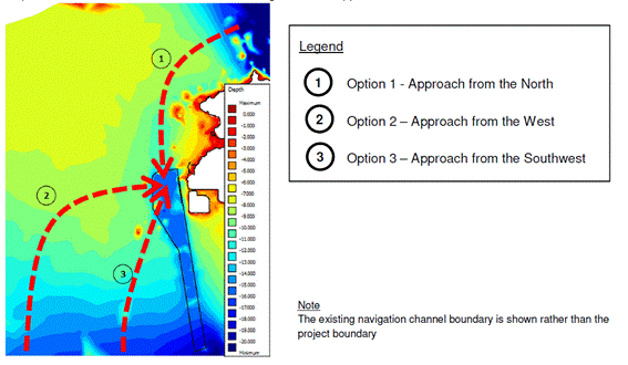
2.5.1.1 Existing Alignment
The existing Channel alignment was originally identified and gazetted to facilitate a direct and efficient route from the south of Lamma to the LPS landing facility, away from popular ferry routes to and from Yung Shue Wan. The alignment follows an approximate north-south approach with the natural bathymetry progressively deeper towards the south.
Given the historic dredging activity in the Channel, this option requires the least dredging during construction phase resulting in the least marine sediment disposal requirements overall and subsequently reducing the ongoing costs and disturbance of the seabed from dredging. The natural siltation rate for this Channel alignment is already known given the historic dredging activities and bathymetry surveys carried out by HK Electric, which increases the level of confidence on the natural siltation rates that would be expected for enabling better planning / scheduling of recurrent improvement dredging activities.
2.5.1.2 Option 1 – Approach from the
North
A Channel approach from the north would need to cut westwards from the East Lamma Channel, one of the main shipping routes in Hong Kong, and would likely conflict with popular ferry routes to and from Yung Shue Wan on Lamma Island increasing the risks associated with marine hazards. Due to the existing bathymetry along this route, with seabed levels as shallow as -8 mPD, and channel length almost double that of the existing, the dredge volumes required for improvement dredging would be substantially greater, resulting in significant cost, programme and marine sediment disposal implications. The rate of siltation and sediment quality in this area is undetermined, which affects planning of maintenance requirements and costs of future dredging. This alignment would avoid environmentally sensitive receivers along the west Lamma coastline, but is closest to environmentally sensitive receivers along the north Lamma coastline.
2.5.1.3 Option 2 – Approach from the
West
An approach from the west would need to cut eastwards from the West Lamma Channel, requiring a length significantly longer than the existing alignment with seabed levels of depths similar to Option 1. Thus the cost, programme and marine sediment disposal volumes would be substantially greater than the existing alignment option. The change in the orientation of the incoming/outgoing vessel direction may necessitate a change in the LPS jetty infrastructure to accommodate. The sediment quality for much of this area is unknown, presenting sediment disposal risks. Conversely, this alignment would present advantages in that the alignment would shift further away environmentally sensitive receivers along the Lamma coastline.
2.5.1.4 Option 3 – Approach from the
Southwest
An approach from the southwest would present no significant benefits over the existing alignment. The route would be slightly longer and with seabed level profiles reaching approximately -10 mPD, the volumes of dredged sediment and subsequent disposal requirements would be more substantial than the existing alignment during Channel formation. This alignment and its approach also conflicts with the proposed ‘Development of a 100MW Offshore Wind Farm in Hong Kong’ project, which may significant affect the feasibility of this alternative option.
Table 2-1: Summary of Environmental Benefits and Dis-Benefits of Alignment Options
|
Alignment Options |
Environmental Benefits |
Environmental Dis-Benefits |
|
Existing Channel Alignment |
§ Makes use of existing dredged areas thereby reducing initial quantity of marine sediment to be dredged § Maximises the naturally deeper bathymetry to the south thereby minimising the need for dredging of southernmost extent § Alignment avoids ecologically sensitive areas towards the north and west of Lamma § No dredging of contaminated sediments required (Category L confirmed by previous sampling and testing) |
§ Alignment is closer to ecologically sensitive areas along west Lamma coastline. |
|
Alternative Channel Alignment Option 1 - Approach from the North |
§ Alignment avoids ecologically sensitive areas along west Lamma coastline |
§ Existing bathymetry is relatively shallow hence a larger dredging quantity is required for initial Channel formation § Longer Channel length required to reach the naturally deeper waters at East Lamma Channel required for approach by ocean going vessels § Wider Channel width required to provide the sloping edges needed to ensure stability of the Channel depth, hence greater habitat disturbance / loss § New marine habitat areas directly affected § Alignment is closer to ecologically sensitive areas along northern Lamma coastline § Rate of siltation is likely to be higher due to naturally higher seabed levels surrounding the Channel. |
|
Alternative Channel Alignment Option 2 - Approach from the West |
§ Alignment avoids ecologically sensitive areas along the Lamma coastline |
§ Existing bathymetry is relatively shallow hence a larger dredging quantity is required for initial Channel formation § Longer Channel length required to reach the naturally deeper waters to the south of Lamma required for approach by ocean going vessels § Wider Channel width required to provide the sloping edges needed to ensure stability of the Channel depth, hence greater habitat disturbance / loss § New marine habitat areas directly affected § Alignment is closer to ecologically sensitive areas along Cheung Chau coastline § Rate of siltation is likely to be higher due to naturally higher seabed levels surrounding the Channel. |
|
Alternative Channel Alignment Option 3 - Approach from the Southwest |
§ Alignment avoids ecologically sensitive areas towards the north of Lamma and reduces the proximity to ecologically sensitive areas along west Lamma coastline |
§ Part of the existing bathymetry is relatively shallow hence a larger dredging quantity is required for initial Channel formation compared to the Existing Channel, but less than for Alternative Channel alignment options 1 and 2 § Longer Channel length required to reach the naturally deeper waters to the south of Lamma required for approach by ocean going vessels compared to the Existing Channel, but less than for Alternative Channel alignment options 1 and 2 § New marine habitat areas directly affected. |
Based on the alignment option evaluation, it is clear that both environmental and technical / operational dis-benefits of the alternative options outweigh the benefits that may be accrued from these alternative alignments. Thus the existing Channel alignment remains the preferred option for enabling coal vessel entry and coal delivery to LPS.
2.5.2
Dredging Methods
The following dredging technologies were reviewed as part of this study to identify the feasibility and environmental impacts of their use for the Project:
§ Grab Dredger
§ Suction Dredger:
– Plain Suction Dredger
– Trailing Suction Hopper Dredger (TSHD)
§ Bucket Ladder Dredger
§ Backhoe Dredger.
A summary of the key operational characteristics and environmental issues related to the use of the aforementioned dredge technologies is provided in Table 2-2.
Table 2-2: Summary of Dredging Technology
|
Dredger Type |
Operational Characteristics |
Environmental Issues |
Feasibility |
|
Grab |
· Relatively low productivity · Suitable for various dredge depths and sediment types |
· Suspended solids (SS) released during impact on seabed and during hoisting · Silt curtain enclosure can be used |
Feasible |
|
Suction (Plain) |
· Productivity affected by clay and debris · Stationary – anchorage required · Continuous operation · Not suited to offshore dredging |
· SS released near seabed level · Silt curtain may be deployed |
Feasibility undetermined / restricted |
|
Suction (TSHD) |
· Productivity affected by clay and debris · High mobility · Non-continuous operation |
· SS released near seabed level · Silt curtains cannot be applied |
Feasible |
|
Bucket Ladder |
· Stationary – anchorage required · Suitable for various sediment types · Not suited to offshore dredging |
· Noise impacts from operation · SS released near bucket · Silt curtain can be deployed |
Feasibility undetermined / restricted |
|
Backhoe |
· More suited to coarse material dredging · Depth restricted · Not suited to offshore dredging |
· SS released throughout water column · Silt curtain can be deployed |
Feasibility undetermined / restricted |
As presented in Table 2-2, only the grab dredger and the TSHD are confirmed as feasible for deployment on this Project, particularly as the other dredging options are generally not suitable for offshore dredging. These two types of dredgers are also the most commonly available types used in Hong Kong with demonstrated track records and suitability for the marine environment in Hong Kong. The grab dredger method also has the option of using closed grabs, which would provide additional environmental benefits by further reducing potential SS release. Based on these considerations, the grab and TSHD dredging methods are identified as the preferred dredging options for this Project.
In terms of dredging rates, the Project seeks to derive the maximum allowable dredging rates within the Project area so as to enable both construction phase and operation phase recurrent dredging without causing any adverse environmental impact. This maximum allowable dredging rate, which has been fine-tuned based on water quality impact modelling and assessment, represents a cap on the dredging rates that may be adopted by the Project. As those dredging rates that are less than this maximum allowable rate would similarly have no adverse environmental impact, all dredging rates below the maximum allowable rate are acceptable and no specific alternative dredging rates need to be considered. Further elaboration on the maximum allowable dredging rates may be referred from Chapter 3.
2.5.3
Phased Implementation
For this Project which seeks to enable both construction phase and operation phase recurrent dredging, the staging or phasing of implementation cannot be fixed as the implementation requirements would depend on detailed dredging hotspots within the Channel (determined by bathymetry surveys prior to each dredging activity) and Contractor’s arrangements. However, implementation of the dredging programmes for both construction and operation phases will take into account the environmental requirements / constraints imposed by this EIA study, which includes the following:
§ Restrictions on concurrent dredging zones / dredging rates (whereby the zone with the lowest daily dredging rate would apply in total to any concurrently dredged zones) to avoid adverse water quality impacts at water sensitive receivers
§ Restrictions on the numbers of plants to avoid adverse construction noise impact to noise sensitive receivers (up to 5 concurrent dredgers due to practical constraints)
§ Precautionary measures for protection of ecologically sensitive areas during defined periods e.g. areas affected by Finless Porpoise calving season.
By defining the limits of dredging activities (rates, numbers of dredgers and active periods), all phases or stages of implementation conducted within these boundaries would be environmentally acceptable, hence no specific phasing or staging of implementation will be recommended for this Project.
2.5.4
Use of Smaller
Vessels
Operations at the LPS have been optimised based on coal demand, coal storage facilities, market availability of coal vessels and the LPS jetty configuration.
To ensure the security of coal supplies for base load power generation at LPS, the market availability of ocean going coal vessels that are compatible with the LPS jetty requirements / restrictions is an important factor governing the suitability of any type of vessel employed for coal delivery to LPS. A key requirement of the LPS jetty is for vessels to be gearless (vessels without lifting appliances and accessories on vessel deck), to enable the unloading facilities at LPS jetty to be safely operated.
The current practice in chartering coal vessels to deliver coal to LPS is based on maximum draft of 14.6 m with length and beam not exceeding 262 m and 40 m respectively as stipulated in the Berthing Guidelines of Marine Department. The deadweight size of the coal vessels under the above specification is around 70,000 to 90,000 MT. According to information from shipping agents, there are currently about 1,800 vessels of this size and are gearless available in the market worldwide, that fit into the category and are thus suitable for coal delivery to LPS.
The possibility of using smaller size vessels with smaller arrival draft for transporting coal to LPS has been explored. According to information from shipping agents, there are currently about 3,600 vessels worldwide with deadweight sizes ranging from 50,000 – 70,000 MT, however, only about 1% of these vessels are gearless that can suit the jetty unloading facilities for safe unloading operation. This is considered practically not feasible due to the difficulty in sourcing and securing suitable gearless vessels in this category to meet the coal delivery schedule that is necessary to ensure reliability in electricity generation at LPS. Given this critical constraint, the option of adopting smaller vessels to meet the coal delivery requirements of the Project must be ruled out.
2.5.5
Need for
Operation Dredging
As presented in Section 2.2, periodic dredging of the Channel is necessary to counteract the effects of natural siltation and to maintain compliance with the Marine Department’s Berthing Guidelines for minimum channel depth, which ensures safe passage for ocean going vessels delivering coal supplies to LPS. The primary factors affecting operation phase recurrent dredging are thus the siltation rate and the operational requirements of the Channel.
2.5.5.1 Historical
Siltation Rates
Historic dredging in the Channel has been to a depth of between -16.0 mPD and -16.5 mPD with a minimum slope maintained between the Channel boundary and the natural bathymetry outside the Channel to provide stability against slope collapse. Siltation rates within the Channel vary locally depending on the hydrodynamic properties prevalent in the area, with the edges of the turning basin and the narrow access strip being particularly prone to developing high spots. Upon the formation of the Channel in around 1980, several seabed surveys were conducted in subsequent years to assess the siltation rate of the Channel and an average siltation rate of 0.2 m per year was then adopted. Following the advancement of bathymetry survey technology using multi-beam echo sounder in the mid-1990s, more accurate seabed profiles of the Channel could be measured.
Based on the recent bathymetry data of the Channel, the annual average and peak siltation rates for the past 10 years are shown in Table 2-3.
Table 2-3: Siltation Rates Based on Past Bathymetry Records
|
Period of Bathymetry Record* |
Annual Average Siltation Rate across the Whole Channel (m/yr) |
Peak Siltation Rate based on location of High Spots (m/yr) |
|
2004 to 2007 |
0.19 |
0.50 |
|
2010 to 2013 |
0.11 |
0.29 |
|
2014# |
0.07 |
0.30 |
* Note siltation rates are determined by comparing bathymetry records for consecutive years, however bathymetry records are not available for every year, hence some of the annual average siltation rates represent the average over a period (range) of years.
# Note for the estimate of recurrence frequency in Section 2.5.5.4, the annual average siltation rates for singular years (2014) are not used as these reflect single year events only and are not appropriate for considering average or peak siltation that can be accrued over a number of years.
As shown in Table 2-3, peak siltation rates can be much higher than average siltation across the Channel. Such peak siltation rates which tend to occur along the narrow access strip to the LPS are a key concern as they have a greater potential for adversely affecting the safe navigation of marine vessels travelling to and from the LPS.
2.5.5.2 Operational Needs of the LPS
Maintain Channel Depth below -15.65 mPD
Operational requirements of the Channel are specified by the Berthing Guidelines. While the requirement is to maintain the Channel depth to a minimum of -15.65 mPD, in practice, it would not be viable to dredge only to a depth of -15.65 mPD as this would provide no buffer against natural siltation and would result in excessively frequent dredging to maintain this minimum depth requirement. The depth of the Channel thus must be maintained at a suitable depth below -15.65 mPD to provide adequate buffer and avoid excessively frequent dredging to meet operation requirements.
Adequate Lead Time for Preparation of Each Dredging Event
Planning and preparation of each dredging event involves undertaking bathymetry survey, sediment sampling and testing, application for sediment disposal allocation under the Dumping at Sea Ordinance, application to Marine Department for the promulgation of Marine Department Notice to notify the concerned public on the dredging area and programme, notification and engagement with relevant stakeholders, tendering and award of the dredging contract, and finally commissioning of the dredging event. Based on experience from the previous dredging works, the planning and preparation process before commencement of each dredging event requires approx. 12 months lead time.
Restrictions during Peak Seasons
Peak season typically occurs for a few months in the summer when energy demand is highest. During these peak periods, coal vessel delivery needs to be optimised to provide a near continuous coal supply. This requires careful scheduling of coal vessel entry to and exit from the Channel. During these high energy demand periods, dredging within the Channel would be severely restricted, with dredgers required to temporarily demobilise and exit the Channel every time a coal vessel movement is required. This represents a sub-optimum condition for improvement dredging while also increasing both operational scheduling and marine safety risk (in the event of accidental conflicts between the coal vessels and the dredgers). Scheduling of recurrent improvement dredging events during summer months should thus be minimised as far as practicable.
2.5.5.3 Dredging Frequency and Depth
Effects of Siltation and Operational Requirements
Taking into account the effects of siltation and the operational requirements and constraints described above, it is clear that the dredging frequency cannot be excessively frequent (e.g. annually) as this would not be practical to implement and would incur unacceptable safety risk (if the siltation in the Channel is not attended to before the minimum depth requirement is reached). To provide a reasonable dredging frequency, an appropriate dredging depth with adequate buffer below the minimum channel depth of -15.65 mPD must be determined.
Effect of Dredging Depth on Recurrent Dredging Frequency and Quantity
Dredging depth is linked to dredging frequency and quantity. If the dredging depth is small (i.e. relatively shallow) with a small buffer from the minimum channel depth, more frequent dredging of small quantities would be required to maintain the Channel, whereas if the dredging depth is large (i.e. deeper) with a large buffer, less frequent dredging but of larger quantities would be required.
For construction phase, given that certain areas of the Channel have already accrued siltation above the minimum depth requirement, the deeper the dredging depth, the larger the amount of marine sediments to be dredged during the first re-profiling of the Channel. Dredging depth thus has an appreciable effect on dredging quantity during construction phase.
During the recurrent dredging or operation phase after the Channel has been re-profiled to a specified target depth, the dredging quantity is primarily dependent on siltation rate. Thus for the same dredging extent, the total dredging quantity over a long period of time (say 20 years) is equal to the amount of dredged sediments per dredging event multiplied with the number of dredging events in that period of time. Therefore, the dredging depth has no effect on the total dredging quantity in the long term, except if the dredging extent is increased due to a larger slope formation area, in which case an additional dredging quantity would apply.
2.5.5.4 Consideration of Different Target
Dredging Depths
In view of the effects of siltation, operational requirements as well as the dynamics between dredging frequency and quantity as detailed in Section 2.5.5.3, the pre-requisite requirements are as follows:
Pre-requisite Requirements
§ Maintain an adequate buffer below the minimum channel depth of -15.65 mPD to ensure safe navigation of marine vessels travelling to and from the LPS; and
§ Avoid excessively frequent recurrent dredging that is impracticable from the operational perspective.
As explained in Section 1.1.1, past dredging to -16.0 mPD is not a viable long term solution as this dredging depth does not provide adequate buffer below the minimum channel depth requirement and the high recurrence frequency would result in extremely high risks to navigation safety, which is unacceptable and cannot be permitted as part of the long term management of the Channel.
Without resorting to excessively deep dredging depths, two viable options for long term maintenance of the Channel at -16.5 mPD and -17.0 mPD are considered. The key considerations for identifying the suitable dredging depth (and frequency) are as follows:
Key Considerations
1. Minimize the impact on marine environment due to the first re-profiling during construction phase by reducing the dredging quantity;
2. Minimize the disturbance on marine environment due to the recurrent dredging during operation phase by optimizing the dredging frequency; and
3. Minimize the disturbance on marine environment and operation of the Channel due to the duration of each recurrent dredging event.
The different dredging depths are evaluated and the results are described below.
Dredging to -16.5 mPD
Assuming a target dredge depth of -16.5 mPD, the available buffer against the -15.65 mPD minimum channel depth requirement would be 0.85 m. Based on the siltation rates presented in Table 2-3, the range of average siltation would suggest a recurrent dredging frequency ranging between 6 to 10 years for re-profiling of the whole Channel to the specified target dredge depth, whereby the estimated dredging quantity would range from approx. 2.4 Mm3 up to 2.9 Mm3.
In terms of peak siltation (when high spots will occur), the peak siltation rates in Table 2-3 suggest that high spots exceeding the -15.65 mPD requirement may materialise within 2 - 4 years. However, for such high spots to exceed the minimum depth requirement, the accumulated height (0.85 m) would require a proportionally larger base to prevent the high spot mound from collapsing. Due to this additional stability requirement, ‘large mounds’ exceeding 0.85 m in height are less likely to be formed in a short period compared to ‘small mounds’ of < 0.85 m height, hence high spots exceeding the minimum -15.65 mPD requirement are less likely to occur within 2 years and are more likely to occur in 4 years or so.
The first re-profiling (during construction phase) is estimated to generate up to 3.2 Mm3 of sediment. There would be no increase in dredging area (compared to previous dredge depths of -16.0 mPD), as the existing slopes around the Channel have previously been formed based on a Channel depth of -16.5 mPD, hence widening of the slopes would not be required to support and stabilise this Channel depth. Thereafter, with recurrent dredging of localised high spots once every 4 years or so (with estimated dredging quantity up to 0.9 Mm3 each time), full re-profiling of the Channel with a dredging quantity of up to 2.9 Mm3 can be delayed to approx. once every 10+ years. This would meet the operational requirements of the Channel while minimising dredging duration and the quantities of sediment requiring disposal during each recurrent dredging event.
Based on the above evaluation, this target dredge depth performs well against items 2 and 3 of the key considerations. It also performs acceptably against item 1, as the additional construction phase dredging quantity is limited to the additional depth dredged within the Channel and the need for widening of slopes has been avoided.
Dredging to -17.0 mPD
Assuming a target dredge depth of -17.0 mPD, the available buffer against the -15.65 mPD minimum channel depth requirement would be 1.35 m. Based on the siltation rates presented in Table 2-3, the range of average siltation would suggest a recurrent dredging frequency ranging between 9 to 15 years for re-profiling of the whole Channel to the specified target dredge depth, whereby the estimated dredging quantity would range from approx. 3.6 Mm3 up to 4.0 Mm3. The peak siltation rates in Table 2-3 suggest that high spots exceeding the -15.65 mPD requirement may materialise within 4 - 6 years, however, such high spot occurrences are more likely to occur in 6 years or so due to the even larger base required for mound formation as explained earlier.
This target dredge depth option provides the longest recurrence frequency. However, the sediment quantities that would need to be dredged during the first re-profiling event (up to 4.7 Mm3 during construction phase), and each recurrent dredging event (up to approx. 1.5 Mm3 for localised dredging of high spots once every 6 years or so and up to 4.0 Mm3 for each re-profiling event every 15+ years) would be very significant and would be more difficult to dispose. The significantly larger construction phase dredging quantity is partly due to the need for slope widening. As the Channel has not previously been re-profiled to -17.0 mPD, the existing sloping bathymetry around the Channel is inadequate to provide stability against slope collapse and hence would need to be widened as a result. This not only incurs substantial additional dredged volume during construction phase but the wider sloping area would also need to be maintained in the long term. With such large dredging quantities, and taking into account the constraints to the dredging periods (during summertime as well as other restrictions such as avoidance of Finless Porpoise calving season), the dredging duration would inevitably be lengthy and prolonged.
Based on the above evaluation, this target dredge depth performs well against item 2 of the key considerations only and performs poorly against items 1 and 3. When compared with the -16.5 mPD option, this target dredge depth of -17.0 mPD is not considered to provide the optimum solution for long term management and maintenance of the Channel.
2.5.5.1 Recommended
Option for Operation Phase (Recurrent) Dredging
With the key considerations which aims to minimise dredging quantity while optimising dredging frequency, and based on the comparison between the different target dredge depths, the results show that -16.5 mPD would provide the best target dredge depth to meet these aims while conforming with operational requirements of the Channel.
2.5.6
Summary of
Options Evaluation and Selection of Preferred Option
Based on the evaluation of alternatives and options for the Project, a summary of the findings and the identified preferred options are presented in Table 2-4.
Table 2-4: Summary of Options Evaluation and the Preferred Option
|
Alternative Option |
Environmental Dis-benefits |
Environmental Benefits |
Preferred Option |
|
Channel Alignment Options |
|
|
|
|
Existing Alignment |
· Closer proximity to ecologically sensitive areas along west Lamma coastline |
· Natural bathymetry lends itself to reduced dredge requirements · Sediment quality (confirmed as uncontaminated) and siltation rates are known · Increased distance from ecologically sensitive areas along northern Lamma coastline |
ü |
|
Option 1 - Approach from the North |
· Larger dredge volumes · New marine habitat areas directly affected · Unknown sediment quality and future siltation rates · Close proximity to ecologically sensitive areas along northern Lamma coastline |
· Increased distance from ecologically sensitive areas along west Lamma coastline
|
û |
|
Option 2 - Approach from the West |
· Larger dredge volumes · New marine habitat areas directly affected · Unknown sediment quality and future siltation rates · Closer proximity to ecologically sensitive areas along Cheung Chau coastline |
· Increased distance from ecologically sensitive areas along the Lamma coastline |
û |
|
Option 3 - Approach from the Southwest |
· Larger dredge volumes compared to existing Channel · New marine habitat areas directly affected
|
· Increased distance from ecologically sensitive areas towards the north of Lamma and along west Lamma coastline |
û |
|
Dredging Method Options |
|
|
|
|
Grab Dredger |
· SS released throughout the water column |
· Widely used in Hong Kong waters · Water quality impacts significantly reduced through silt –curtain application |
ü |
|
Suction Dredger (Plain) |
· Mitigation measures cannot be applied to further minimise water quality impacts |
· Water quality impacts can be insignificant · Efficient technology resulting in efficient dredge programme |
û |
|
Suction Dredger (TSHD) |
· Mitigation measures cannot be applied to further minimise water quality impacts
|
· Widely used in Hong Kong waters · Water quality impacts can be insignificant · Efficient technology resulting in efficient dredge programme |
ü |
|
Bucket Dredger |
· Noise impacts from operation · Water quality impacts from high rate of SS release |
None |
û |
|
Backhoe Dredger |
· Water quality impacts from high rate of SS release |
None |
û |
|
Channel Depth Options / Need for Operation Dredging |
|||
|
- 16.5 mPD |
· Relatively shorter recurrence frequency
|
· No increase in dredging area · Less sediment quantity required for dredging and disposal · Duration of construction phase and dredging quantity would be minimised by rotating between selected high spot dredging and full re-profiling |
ü |
|
- 17.0 mPD |
· Large sediment quantity required for dredging and disposal · Long dredging duration and associated marine ecology disturbance and sediment release · Larger dredging area required to form stable slopes |
· Longer interval between dredging periods |
û |
2.6 Work Programme
The initial improvement dredging of the Channel to a target depth of - 16.5 mPD constitutes the construction phase of the Project for the purpose of this EIA study. With construction phase scheduled to commence in 2019, and taking into account annual accrued siltation rates, the preliminary estimated sediment quantity to be dredging during construction phase is up to approx. 3.2 Mm3. While the Contractor is yet to be engaged, it is expected that construction can be completed between 12 months and 18 months, but will be subject to the Contractor’s arrangements. The programme takes into account the requirement for all dredging operations to be suspended when scheduled coal delivery vessels approach and depart the Channel and LPS jetty.
Given the rate of natural siltation in the Channel, as stated in Section 2.2, periodic improvement dredging will be required throughout the operation phase to maintain sufficient clearance in the Channel. Recurring improvement dredging during operation phase is targeted to a dredge depth of -16.5 mPD[1]. Based on the estimates presented in Section 2.5.5.4, recurrent improvement dredging during operation phase will be required approximately once every 4 to 10 years in order to maintain sufficient clearance. As full re-profiling of the Channel would not be required for every recurrent dredging event, the dredging volumes would be minimised to approx. 0.9 Mm3 for recurrent dredging events every 4 years or so, which would delay the full re-profiling to every 10+ years, with an estimated dredging volume of up to approx. 2.9 Mm3 (to re-profile the whole Channel with stable slopes). These dredging quantities represent the upper limit for environmental assessment purpose. Actual dredging quantities would be within this upper limit and subject to bathymetry surveys to be conducted before each recurrent dredging event.
2.7 Potential Concurrent Projects
Concurrent projects in the vicinity of the Project area which have been determined as having potential cumulative environmental impacts on the Project during construction and/ or operation phase are indicated in Table 2-5.
Table 2-5: Summary of Concurrent Projects Considered for Cumulative Impact Assessment
|
Concurrent project |
Project status |
Cumulative environmental impacts considered |
|
Planning and Engineering Study on Future Land Use at Ex-Lamma Quarry Area at Sok Kwu Wan, Lamma Island - Feasibility Study |
· EIA Study Brief
obtained · Construction anticipated from 2019 to 2024 |
Construction Phase Water quality impacts associated with dredging activities required for the construction of a diffuser for a submarine outfall from a sewage treatment works, resulting in release of suspended sediment. |
|
1,800MW Gas-fired Power Station at Lamma Extension |
· Approved EIA report · Construction programme for Unit L10 scheduled from 2016 to 2019 |
Construction Phase Noise impacts associated with the construction of the package plant. |
|
Development of a 100MW Offshore Wind Farm in Hong Kong |
· Approved EIA report · No information on construction programme commencement available |
Construction Phase Water quality impacts of suspended sediment release from dredging works, seabed jetting for cable laying and scour protection for wind turbine foundations. |
|
Integrated Waste Management Facilities at an Artificial Island near Shek Kwu Chau |
· Approved EIA report · No information on construction programme commencement available |
Construction Phase Water quality impacts of suspended sediment release from reclamation works and dredging to form anti-scour breakwater. |
|
Providing Sufficient Water Depth for Kwai Tsing Container Basin and its Approach Channel |
· Approved EIA report · Construction phase is anticipated to be completed before 2017 |
Operation Phase Water quality impacts of suspended sediment release during operation dredging. |
|
Hong Kong Offshore LNG Terminal |
· EIA Study Brief
obtained · Under development stage |
Not considered as no information on the environmental impacts of the proposed works is available. |
|
The Baroque on Lamma |
· EIA Study Brief
obtained · No information on proposed construction programme available |
The EIA has not yet been submitted and the project has not yet been given go-ahead by Town Planning Board. As such, this project is not a planned and committed project – not assessed for cumulative impacts |
|
Yung Shue Wan Development, Engineering Works - Phase 2 |
· Under planning |
Not considered as no information on the environmental impacts of the proposed works is available. |
Note: Greyed out
projects have not been incorporated in the technical assessments.
Concurrent Projects refer to those projects that are planned / committed or are
currently under construction.
Projects that are already in operation phase (existing) form part of the
existing baseline and are not defined as concurrent projects for
the purpose of this summary. Existing projects will nevertheless form part of
individual environmental assessments, where applicable, and will be detailed in
the relevant technical sections of this EIA report.
[1] While the Project aims to dredge to a target depth of -16.5 mPD, some overdredge may occur due to the limited precision control of dredging depths in practice.