In accordance with Clause 3.4.11 and Appendix H
Requirements for Visual Impact Assessment (VIA) of the EIA Study Brief, a VIA
has been conducted based on mapping with a Geographic Information System (GIS)
and field surveys to help identify the existing conditions so as to be able to
assess the potential visual impacts during construction and operation and glare
associated with the light sources of the Project. The VIA presented here
covers the elements of the Project that are located above sea level.
This
VIA has been prepared according to Clause 2.1 (vi), Clause 3.2 (ix), Clause
3.4.11 and Appendix H of the EIA Study Brief.
Environmental
Impact Assessment Ordinance
(EIAO) legislation (Cap.499, S.16) and the Technical Memorandum on EIA
Process (EIAO-TM), particularly Annexes 10 (Criteria for Evaluating
Visual and Landscape Impact, and Impact on Sites of Cultural Heritage) and 18
(Guidelines for Landscape and Visual Impact Assessment) have been referred
to in carrying out this assessment.
In
addition, the following standards and guidelines have been referred to for
assessing the visual impacts associated with the Project:
·
Environmental
Impact Assessment Ordinance Guidance Note 8/2010 (Preparation of Landscape and Visual
Impact Assessment under the Environmental Impact Assessment Ordinance);
·
Hong
Kong Planning Standards and Guidelines (HKPSG) issued by the Planning
Department (November 2015), in particular Chapter 11 Urban Design Guidelines;
·
Lands
Administration Office (LAO) Practice Note No. 7/2007 Tree Preservation &
Tree Removal Application for Building Development in Private Projects;
·
DEVB
TC(W) No. 7/2015 – Tree Preservation;
·
ETWB
TCW No. 11/2004 – Cyber Manual for Greening;
·
DEVB
TC(W) No.6/2015 – Maintenance of Vegetation and Hard Landscape Features; and
·
Study
on Landscape Value Mapping of Hong Kong ([1]).
The
Project will be implemented at three locations: namely an LNG Terminal in
southwest waters of the HKSAR (refer to Figure 11.1 for the indicative location) and two
GRSs at the existing BPPS and LPS to receive the regasified LNG from the LNG
Terminal (refer to Figure 11.2 and 11.3 showing the indicative locations of the
GRSs at both the BPPS and the LPS, respectively).
The
LNG Terminal will be located in open waters
southeast of the Soko Islands (which consist of Tai A Chau, Siu A Chau and
several smaller nearby islands) and southwest of Shek Kwu Chau. It is not
covered by any existing outline zoning plan (OZP) but is located in the
vicinity of the proposed South Lantau Marine Park to the northwest and the
“Sediment Disposal Area” for disposal of uncontaminated sediment at South of
Cheung Chau to the east (see Figure 11.1).
The
GRS at the BPPS (Figure 11.2) will be constructed within the
boundary of the existing BPPS which is not covered by any OZP. BPPS
is the first natural gas-fired power plant in Hong Kong, built in 1996 near
Lung Kwu Tan in Tuen Mun. The coast at BPPS does not form part of
any Coastal Protection Area (CPA), and the Sha Chau and Lung Kwu Chau Marine
Park is located at least 4.4km by sea from the BPPS. Pak Nai Site of
Special Scientific Interest (SSSI), which is an intertidal mudflat/ mangrove
habitat, is approximately 5km to the north.
The
GRS at the LPS (Figure 11.3) will be constructed within the
boundary of the existing LPS, covered by the approved Lamma Outline Zoning
Plan S/I-LI/11 under zoning ‘Other Uses – For “Power Station” only’.
LPS is a coal and gas-fired power station located in Po Lo Tsui, Lamma Island
and built in 1982. The GRS is therefore located in accordance with the
planning intent of this area. The coast at LPS does not form part of any
CPA. Sham Wan SSSI, a site with beach and shallow bay known for a nesting
site for Green Turtle, is located approximately 1.5km to the southeast of the
LPS.
Consideration
has also been given to land uses and planning for committed/ planned projects
that potentially interact the current Project. These are discussed in Section
11.10.
As per Clause 3.4.11.2 of the EIA
Study Brief, the Assessment Area has been defined by the predicted Visual Envelope of the Project. A
Visual Envelope is an area within which views of the Project will be
possible. Identification of the Visual Envelope has been achieved by site
visit and desktop study of topographic maps and photographs, and GIS analysis,
to determine potential visibility of the Project from various locations.
GIS analysis uses known data regarding the proposed built structures to model
the area that can potentially see the Project. The indicative location of
the LNG Terminal (Figure 11.1 refers) is approximately 4km
east of Tau Lo Chau, near the Soko Islands (the closest land mass).
Indicative dimensions (length x width x
height) of the key components, which have been used for analysis, are:
·
LNG
Terminal, including a Jetty and FSRU Vessel: The FSRU Vessel dimensions are up
to 345m in length by 55m wide, and up to 65m high. The Jetty extends
beyond the FSRU Vessel (see Figure 3.5), as such a visual envelope model has
assumed a conservative length of 500m. For the purpose of the VIA, the
modelling has assumed the LNGC (up to 345m in length by 55m wide, and with mast
reaching up to 65m high) is simultaneously moored at the Jetty with the FSRU
Vessel, as illustrated conceptually in Figure 3.5 and
with both the FSRU Vessel and LNGC at the Jetty, the width will be
approximately 160m. This is a conservative approach as the LNGC
will only be moored when making LNG delivery, assumed to be once every five to
eight days. As such the VIA assumes dimensions of the LNG Terminal and
moored LNGC to be no longer than approximately 500m in a horizontal plane (500m
long by 16m wide) and approximately 65m high in a vertical plane;
·
GRS at
the BPPS: approximately 93m x 43m x 16m; and
·
GRS at
the LPS: approximately 150m x 80m x 12m.
It
should be noted that GIS analysis uses topographic data as a baseline,
disregarding existing built forms and vegetation which reduce the actual Visual
Envelope. In addition the maximum heights at the GRS are due to
water heater vent stacks (which in nature will be of relatively narrow
diameter) and the main GRSs, which consist generally of piping work, will be
lower. Figure 11.22 provides photographs of the existing
GRS structures at the BPPS and the LPS as reference.
Figure 11.4 and Figure 11.5
illustrate the GIS analysis of the predicted
Visual Envelope
for this Project around the LNG Terminal and the GRSs respectively. Figure 11.4 also gives an
indication of how far viewers are from the LNG Terminal. As a viewer moves further away from the
LNG Terminal, the visual impact decreases until the terminal is no longer
visible. However, before the point of invisibility is reached, the
terminal has reduced in scale such that it no longer has a significant visual
effect on the view.
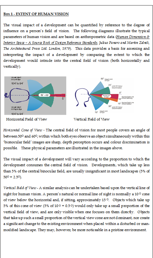
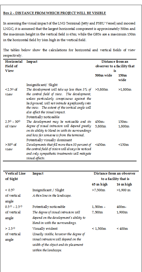
Considering
the potential proportions of the LNG Terminal as stated above, Boxes 1
and 2 below show that views further than 10km away are unlikely to be
significant, with most views insignificant over 7.5km. However, some key
viewers and vantage points up to 20km away on Lamma Island have been considered
in this study, given their potential sensitivity for completeness.
Identification of Visual
Sensitive Receivers (VSRs) & Vantage Points (VPs)
Having determined the Assessment Area
for the VIA, VSRs have been broadly identified within the predicted Visual
Envelope. VSRs may include the people who would reside, work, play
within, or travel through the predicted Visual Envelope and be potentially
under the impact of the Project.
Vantage
Points, or Viewpoints (VPs), have been selected to represent VSRs with a view
to the Project. They are selected to help illustrate the visual change
that would be brought about by the Project and ensure that in combination they
give a good overall representation of how the Project will appear to different
types of VSRs, both near and far, at sea level as well as lower and higher
ground elevations.
VSR Sensitivity
Assessment
of the sensitivity of VSRs is influenced by a number of factors including the
following:
·
Type of
VSR. VSRs are categorized according to whether the viewer is at home, at
work or school, at play or leisure, or travelling (ranked by the major VSR
types, as described below):
-
Residential
VSRs – These
VSRs are people living in the area and who view the Project from their homes.
They are considered the most sensitive VSRs due to the character of the view
from their homes having a substantial effect on their perception of quality and
acceptability of their home environment and general quality of life.
-
Occupational
VSRs – These
VSRs are people working or in education in the area, who view the Project from
their workplace or education centre. Visual amenity is in general not
considered a top priority within the average workplace and these VSRs are
considered to be relatively less sensitive than residential VSRs as their view
will have a less important, although still material, effect on their perception
of quality of life. The degree to which this applies to workers depends
on whether their location is industrial, retail or commercial. The VSRs
in industrial areas, such as factories, are generally considered to be the
least sensitive, due to the relatively low quality of their existing view in an
industrial area.
-
Recreational
VSRs – These
VSRs are people engaging in recreational activities such as hikers on
established trails and footpaths, people participating in team sports at
recreation grounds or at leisure. Sensitivity of these VSRs depends on duration
of stay, nature of the activity and how enclosed the location is.
-
Travelling
VSRs – These
VSRs are people travelling on roads, railways, and on marine vessels, both in
public and private vehicles/ vessels and on foot. They have varying
sensitivity depending on the speed, nature and frequency of travel, but are
generally considered to be transitory to the area with less regard for the
surrounding views and with low sensitivity.
·
Number of
individuals (ranked as very many, many, few or very few);
·
Quality
of existing view (ranked as good, fair or poor);
·
Availability
of alternative views (ranked as yes or no);
·
Degree of
visibility (ranked as full, partial or glimpse);
·
Duration
of view (ranked as long, medium or short); and
·
Frequency
of view (ranked as frequent, occasional or rare).
The
sensitivity of each VSR is based on the values of all the above factors in
totality and classified as follows:
High: The VSR is highly sensitive
to any change in their viewing experience.
Medium: The VSR is moderately
sensitive to any change in their viewing experience.
Low: The VSR is only slightly
sensitive to any change in their viewing experience.
The
physical presence of the Project has been reviewed to identify potential visual
impacts and their significance relative to the sensitivity of the
resource/receptor and the magnitude of change caused by the impact.
Magnitude
of Change
The
magnitude of change caused by a visual impact is quantified according to a
number of factors including the following:
·
Distance
between the closest source of impact and the VSR (given in metres);
·
Scale of
the development. This is assessed using a number of factors, including:
absolute dimensions of new built structures visible to the VSR; relative
dimensions of the new built structures compared to other structures visible to
the VSRs in their existing view (ranked as small, medium or large);
·
Potential
blockage of view (ranked as full, partial or nil);
·
Duration
of the impacts (ranked as temporary [short/medium term] or permanent);
·
Compatibility
of the Project and associated works with the existing and planned landscape in
the vicinity (ranked as good, fair or poor); and
·
Reversibility
of change (ranked as reversible or irreversible).
The magnitude of change caused by visual
impacts on each VSR is based on the values of all the above factors in totality
and classified as follows:
Large: VSRs would suffer a major
change in their viewing experience.
Intermediate: VSRs would suffer a moderate
in their viewing experience.
Small: VSRs would suffer a small
change in their viewing experience.
Negligible: VSRs would suffer no
discernible change in their viewing experience.
Ranking
Impact Significance Threshold
Significance
of an impact is categorised according to the relationship between the magnitude
of change it causes and the sensitivity of the receptor it acts upon. Table 11.1 shows a logical,
well-reasoned and consistent means of dividing the degree of significance into
four thresholds, namely insignificant, slight, moderate, and substantial,
depending on the combination of magnitude of change and receptor sensitivity.
Table 11.1 Relationship
between receptor sensitivity and magnitude of change in defining impact
significance threshold*
|
|
|
Magnitude
of Change
|
|
|
|
Negligible
|
Small
|
Intermediate
|
Large
|
|
Receptor Sensitivity (VSR)
|
Low
|
Insignificant
|
Slight
|
Slight/ Moderate
|
Moderate
|
|
Medium
|
Insignificant
|
Slight/ Moderate
|
Moderate
|
Moderate/ Substantial
|
|
High
|
Insignificant
|
Moderate /Slight
|
Moderate/ Substantial
|
Substantial
|
|
|
|
|
|
|
|
*In those instances where
there are two possible ratings of impact significance threshold, consideration
will be made of all factors concerned and justification provided in
the description of the impact significance threshold if the
lower threshold is predicted.
The
four thresholds for the degree of significance are explained below. All
impacts will be assumed to be adverse in the text of the Report, unless
specifically identified otherwise.
Substantial: Adverse /
beneficial impact where the Project will cause significant deterioration or
improvement in existing landscape quality
Moderate: Adverse
/ beneficial impact where the Project will cause a noticeable deterioration or
improvement in existing landscape quality
Slight: Adverse /
beneficial impact where the Project will cause barely perceptible deterioration
or improvement in existing landscape quality
Insignificant: No discernible change in the
existing landscape quality.
Following
the implementation of mitigation measures, the significance of the impact (the
residual impact) may be reduced.
Having
identified and ranked the significance of potential impacts, measures have been
proposed to mitigate impacts, where necessary. Firstly, means by which
impacts can be avoided will be considered, then possible means that might
reduce the impact magnitude, and also measures that potentially enhance visual quality.
Mitigation measures may take the form of:
·
Adopting
alternative design or revising the basic engineering and / or architectural
design, to prevent and / or minimize adverse impacts. Alternative alignment(s),
design(s) and construction methods that avoid or reduce the identified impacts
will be evaluated for comparison before adopting other mitigation or
compensatory measures to alleviate impacts;
·
Remedial
measures such as colour and textural treatment of physical, engineering and
building features.
An
overall assessment of the acceptability, or otherwise, of visual impacts is
provided in the Conclusion, in accordance with the five criteria set out in Annex
10 of the EIAO-TM is provided, considering the guidelines in
paragraph 3.11 of Environmental Impact Assessment Ordinance GN No. 8/2010.
As
detailed in Section 11.3 and illustrated in Figure 11.4,
the indicative location of the LNG Terminal is in open waters about 4 km
east of Tau Lo Chau, near the Soko Islands. The Project is located
in a relatively open sea area with high degree of visibility to a large area
from a visual perspective. According to the predicted Visual Envelope,
the nearest residential village area is the Cheung Sha area, at a distance of
over 8 km away.
The
LNG Terminal site will be visible to parts of the south facing coastline on south
Lantau Island and elevated areas of the Lantau South Country Park, where not
blocked by other islands such as the Soko Islands and Cha Kwo Chau.
Several islands with limited numbers of visual sensitive receivers are also
expected to have views, including Soko Islands and Shek Kwu Chau. Marine
sea farers e.g. ferry passengers, fishermen, or recreational vessels, will have
views to the LNG Terminal site (see Figure 11.18
which represents marine sea farers on the Macau Ferry Route and
vicinity between Soko Islands and Shek Kwu Chau).
For
the residents on Cheung Chau, views to the LNG Terminal site are largely
blocked by existing structures (seawall, moored vessels in the harbour,
topography and vegetation) as illustrated in Figure 11.7d,
although some
residencies at high elevations and facing southwest over the harbour may have
partial views. Some
areas of the island such
as remote trail areas and tourist spots accessed mainly by visitors and hikers,
also have some occasional
views to the LNG Terminal. On Hei Ling Chau residents and holiday homes
are located in the west of the island which does not fall within the predicted
Visual Envelope but the east, where correctional facilities are located, have a
line of sight to the LNG Terminal, where not blocked by vegetation or the
seawall. The predicted Visual Envelope has been extended to Lamma Island
although this is over 10 km away and is unlikely to experience significant
visual changes (see Section 11.4.1, Box 2).
For
the installation of the GRS at the BPPS, according to the predicted Visual
Envelope (Figure
11.5), the GRS will not be visible to the nearest residential areas
in Lung Kwu Sheung Tan, and the Tsang Tsui hills also shield Tuen Mun from
seeing the GRS. Only workers at the BPPS, and sea farers in the vicinity
of the BPPS waterfront, such as fishermen or recreational vessels, will have
views to the site (See Figure 11.7e which illustrates restricted views in
this area). In comparison, the installation of the GRS at the LPS has a
wider zone of visual influence, mainly affecting sea farers near the LPS (e.g.
fishermen, recreational vessels) and a stretch of coastline to the east of LPS
including beach users at Lo So Shing and hikers along the coastline trail, as
illustrated in Figure 11.5. Figure 11.7c illustrates
that many of the views from this coastline trail are obscured by vegetation.
Overall,
17 Visual Sensitive Receivers (VSRs) have been identified within the predicted
Visual Envelope, including four types as identified in the methodology:
recreational, residential, occupational and travelling. The VSRs include
receivers at ground level, sea level and on elevated ground. The quality
of most existing views for these VSRs affected by the GRSs at the BPPS/ the LPS
and the LNG Terminal, are generally fair and good, respectively, with a high
degree of visibility to natural views containing limited or no anthropogenic
structures. The details of VSRs are summarised in Table 11.2 which includes their
sensitivity.
Table 11.2 VSRs
within the Predicted Visual Envelope
|
VSR ID
|
VSR
Type
|
Description
|
Representative
VP
|
Quality of existing view
|
Alternative Views
|
Receiver population
|
Duration of view
|
Frequency of view
|
Degree of visibility
|
Sensitivity
|
|
LNG
Terminal
|
|
VSR 1
|
R
|
Visitors
and potential future visitors on Soko Islands
|
VP1
|
Good
|
Yes
|
Very few
|
Medium
|
Rare
|
Full
|
Medium
|
|
VSR 2
|
T/ R
|
Sea
farers near Lamma Power Station
|
/
|
Fair
|
Yes
|
Few
|
Short
|
Occasional
|
Glimpse
|
Low
|
|
VSR 3
|
R
|
Hikers
in western Lantau South Country Park
|
VP2,
VP3
|
Good
|
Yes
|
Few
|
Short
|
Rare
|
Partial/Full
|
Medium
|
|
VSR 4
|
R/ H
|
Visitors
and Residents along South Lantau Coastal Area, near Cheung Sha
|
VP4
|
Good
|
Yes
|
Many
|
Long
|
Frequent
|
Full
|
High
|
|
VSR 5
|
H/ R
|
Residents
and Visitors along South Lantau Coastal Area, near Pui O/ Ham Tin
|
VP5
|
Good
|
Yes
|
Many
|
Long
|
Frequent
|
Full
|
High
|
|
VSR 6
|
R
|
Hikers
from Elevated areas of Lantau South Country Park
|
VP6
|
Good
|
Yes
|
Few
|
Short
|
Occasional
|
Partial/ Full
|
Medium
|
|
VSR 7
|
O/ H
|
Inmates,
workers and future workers around Shek Kwu Chau
|
VP7
|
Good
|
Yes
|
Very Few
|
Long
|
Occasional
|
Full
|
Medium
|
|
VSR 8a
|
H
|
Inhabitants
of Cheung Chau
|
/
|
Good
|
Yes
|
Few
|
Long
|
Frequent
|
Glimpse
|
High
|
|
VSR 8b
|
R
|
Visitors
to Cheung Chau
|
VP8
|
Good
|
Yes
|
Few
|
Long
|
Occasional
|
Full
|
Medium
|
|
VSR 9
|
R
|
Recreational
viewers on Lamma Island
|
VP9
|
Fair
|
Yes
|
Few
|
Short
|
Rare
|
Partial/Full
|
Medium
|
|
VSR 10
|
H
|
Inhabitants
of Lamma - Yung Shue Wan area
|
VP10
|
Fair
|
Yes
|
Few
|
Long
|
Rare
|
Glimpse
|
Low
|
|
VSR 11
|
T
|
Sea
farers on the Macau Ferry Route and vicinity
|
VP11
|
Good
|
Yes
|
Very Many
|
Short
|
Rare
|
Full
|
Low
|
|
VSR 12
|
R
|
Hikers
in eastern Lantau South Country Park
|
VP12
|
Good
|
Yes
|
Few
|
Short
|
Rare
|
Partial/Full
|
Medium
|
|
VSR 13
|
O
|
Workers
at Lamma Power Station
|
/
|
Fair
|
Yes
|
Very few
|
Short
|
Occasional
|
Full
|
Low
|
|
VSR 17
|
O/ H
|
Inmates
and workers on Hei Ling Chau
|
/
|
Good
|
Yes
|
Very few
|
Long
|
Occasional
|
Partial
|
Low
|
|
GRS
at the BPPS
|
|
VSR
14
|
T
|
Sea
farers near Black Point Power Station
|
VP14
|
Fair
|
Yes
|
Few
|
Short
|
Occasional
|
Full
|
Low
|
|
VSR
15
|
O
|
Workers
at Black Point Power Station
|
/
|
Fair
|
No
|
Very
few
|
Long
|
Frequent
|
Full
|
Medium
|
|
VSR
16
|
R
|
Visitors
to Black Point Hill and nearby area
|
/(views
largely screened by vegetation, see Figure 11.7e)
|
Fair
|
Yes
|
Very
Few
|
Short
|
Rare
|
Glimpse
|
Low
|
|
GRS
at the LPS
|
|
VSR 2
|
T/ R
|
Sea
farers near Lamma Power Station
|
VP13
|
Fair
|
Yes
|
Few
|
Short
|
Occasional
|
Partial
|
Low
|
|
VSR 9
|
R
|
Recreational
viewers on Lamma Island
|
VP9
|
Fair
|
Yes
|
Few
|
Short
|
Rare
|
Full
|
Medium
|
|
VSR
13
|
O
|
Workers
at Lamma Power Station
|
/
|
Fair
|
No
|
Few
|
Long
|
Frequent
|
Full
|
Medium
|
|
|
|
|
|
|
|
|
|
|
|
|
* Type of VSR is denoted in the ID where R = Recreational;
H = Residential; O = Occupational; T = Travelling
#Workers at Lamma Power Station will have short and
occasional views of the LNG Terminal but long and frequent views of the GRS at
the LPS, therefore sensitivity is rated as low and medium respectively
11.5.2
Selected VPs to
Represent VSRs
As
shown in Figure 11.4, GIS analysis suggests various sections
of the coastal areas in the eastern part of Soko Islands, southwest part of
Lantau Island and western part of Shek Kwu Chau, Cheung Chau and Lamma Island
fall within the visible area for the LNG Terminal. On the other hand, Figure 11.5 suggests sections of the coastal areas
in the western part of Tuen Mun and in the western part of Lamma Island fall
within the visible area for the GRSs in both the BPPS and the LPS. Figures 11.4 and 11.5 and their corresponding zoom in figures provided as Figure 11.6a-d to illustrate the broad VSR areas and specific locations of
VPs. Figure 11.7a-e provide photographs from particular VSRs
(i.e. VSRs 3, 8, 9, 10, 12, 16) with restricted views toward the new Project
structures, to help illustrate how their views are often blocked by vegetation,
existing structures, topography, etc.
To
help assess visual impacts on the identified VSRs, 14 representative Vantage
Points (VPs) have been selected from which to create photomontages. They
have generally been selected to represent the most severely affected
VSRs. The VPs are located both close to and further away from the project
sites and from both sea and land locations, to provide in combination an
overall impression of what the new structures would look like to relevant
VSRs. On land VPs points have been selected on elevated ground with more
panoramic views as well as at lower levels where views are more contained. Table 11.2 indicates which VPs help represent which
VSRs.
VPs to Represent VSRs to the LNG
Terminal
Views from Country Parks and Scenic
Lookouts
VP
1 – Soko Islands. VP
1 is selected to represent viewers on the Soko Islands and any potential future
users on the Soko Islands (e.g. a potential spa and resort ([2]) and visitors to the
proposed South Lantau Marine Park, as the closest land mass to the LNG Terminal
in the area, where VSRs may
be present.
VP2
– Lantau Trail, Stage 8. VP
2 is selected to represent recreational visitors to western Lantau South
Country Park and hikers along the trails from more remote locations of South
Lantau. The selected VP is at around 100 m elevation just above the Lantau
Trail, Stage 8, and has potential open views to the LNG Terminal.
VP3
– Lo Kei Wan. VP
3 represents recreational visitors and hikers to Lantau South Country Park at
Shek Mun Shan. The selected VP at Lo Kei Wan is an officially recognized
AFCD Campsite and one of the closest points along south Lantau coast to the LNG Terminal.
VP6
– Lantau Peak.
VP6 is selected to represent an alternative view of recreational visitors to Lantau South
Country Park and hikers along the trails on South Lantau. The selected VP
at Lantau Peak is a hiking spot and at over 900m elevation represents a
panoramic view out towards the LNG Terminal.
VP12
– South Lantau Country Trail. VP12 is selected to represent recreational visitors/hikers along the
South Lantau Country Trail in the Lantau South Country Park. The selected
VP is a hiking trail and at over 350 m elevation represents a panoramic
view out towards the LNG Terminal.
Views from Villages or Recreational
Beach Areas
VP4
– Cheung Sha Beach. VP
4 is selected to represent swimmers/visitors at Cheung Sha Beach which is a
popular public beach on Lantau Island and it also represents most severely
affected VP for other viewers in this area such as residents in the area and
students and teachers in Lantau International School.
VP5
– Pui O Beach. VP5
is selected to represent recreational
visitors at Pui O Beach. Pui O Beach is another popular public beach in
Lantau Island. Besides, it also represents the residents in Pui O villages.
VP
8 – Cheung Chau.
VP 8 is selected to represent recreational viewers on Cheung Chau. A site
visit showed views from the ferry pier and harbour town area are actually largely obscured by the seawalls
protecting the Cheung Chau Typhoon shelter as well as vessels in the bay.
The selected VP is a remote location in the south west coastal area near Po Yue
Wan, which is accessed mainly by hikers and visitors and has open views across
the seascape to the LNG
Terminal.
VP
9 – Lo So Shing Beach. VP
9 is selected to represents visitors to Lo So Shing Beach, a popular gazette
beach on Lamma Island. The selected VP has open, distant views to the LNG Terminal, as well as closer views to the GRS at
the LPS.
VP
10 – Yung Shue Wan.
VP 10 is selected to represent residents/visitors in Yung Shue Wan. It
has been selected from the ferry route as representing a more severely affected
point around Yung Shue Wan.
Views from Ocean
VP11
– Macau Ferry Route and Vicinity. VP11 is selected to represent viewers in the
vicinity of the Macau Ferry route shipping channel and other nearby sea farers,
primarily those travelling on marine vessels passing near the LNG Terminal
development, such as those travelling between Macau and Hong Kong on the fast
ferries, fishermen or recreational vessels.
Views from Rehabilitation Center
VP
7 – Shek Kwu Chau.
VP 7 represents VSR 7 viewers on or near Shek Kwu Chau as the closest land to
the LNG Terminal
after the Soko
Islands. There are currently limited viewers from here, but they do
include those staff and inmates at a drug rehabilitation center and this
location also represents future users around Shek Kwu Chau (e.g. proposed Integrated
Waste Management Facilities). This VP also serves to illustrate the view
from users of marine vessels in the area.
VPs to Represent VSRs to the GRS at the
LPS
Views from Recreational Beach Areas
VP13
– Offshore area near the LPS. The GRS at the LPS will be visible from the nearby sea
area, hence VP13 has been selected to show affected viewers nearby on the sea (e.g. recreational vessels, water sports
users, fishermen).
VP
9 – Lo So Shing Beach. VP
9 is selected to represents the visitors to Lo So Shing Beach and it has open
views to the GRS at the LPS as well more distant views to the LNG Terminal.
VPs to Represent VSRs to the GRS at the
BPPS ([3])
Views from Ocean
VP14
– Offshore area near the BPPS. The GRS at the BPPS will be most visible from the sea,
hence VP14 has been selected to show the most severely affected viewers as
those nearby on the sea (e.g.
fishermen or recreational vessels).
Options of design schemes illustrated with
photomontages have been prepared from the VPs as described in Section
11.6.
Section
3 Project Description
provides an overview of the Project. The key new components which may
cause visual impacts are listed below. The subsea elements (i.e. the
operation of the subsea pipelines between the LNG Terminal and the two GRSs)
are excluded as they will not be visible.
·
The LNG
Terminal comprising a Jetty and an FSRU Vessel, and moored LNGC; and
·
Two GRSs,
namely the GRS at the BPPS and the GRS at the LPS.
Construction
visual impacts are expected to be minimal and may be caused by:
·
Site
clearance at BPPS and LPS;
·
Excavation
and other civil and building works;
·
Construction
of the Jetty outlined above and as detailed in Section 3.3 Project Design of the Project Description;
·
Installation
of the GRSs located within the BPPS and the LPS.
Operational
visual impacts are expected to be minimal and arise from:
·
the
presence and operation of the new LNG Terminal and the GRSs, including night time lighting such
as for security, general access and emergency (detailed lighting plans and
specifications are not currently available).
Full
details of these new facilities are provided in Section 3.3 Project
Design of the Project Description.
As
illustrated in Figures 11.4 and 11.5,
the predicted Visual Envelope for the Project is relatively large and 17 VSR
groups have been identified, 13 for the LNG Terminal, three for the GRS at the
BPPS and three for the GRS at the LPS. 14 representative VPs have been
selected to represent these VSRs.
Photomontages
have been prepared from the VPs to illustrate the existing conditions, as well
as conceptual visual impacts, for all of: impacts at Day 1 of operation without
implementation of mitigation/ enhancement measures; impacts at Day 1 of
operation with implementation of mitigation/ enhancement measures and residual
impacts at Year 10 of operation with implementation of mitigation/ enhancement
measures. The photomontages supplement the visual changes described in
the text and show that with the limited mitigation/ enhancement measures
necessary and the inconspicuous nature of the proposed mitigation/ enhancement
measures (See Section 11.8), at a distance there is limited
change between the visual impact with or without implementation of mitigation/
enhancement measures.
Photomontages
illustrating the presence of the LNG Terminal (Figures 11.8
to Figure
11.19) and the presence of new GRSs at the BPPS (Figures 11.21)
and LPS (Figure
11.20) from the VPs, help illustrate that the magnitude of visual
change for all VSRs are negligible to small. Those VSRs that are closer
to the LNG Terminal are expected to experience relatively higher magnitude of
change, with all those at 10km or more from the LNG Terminal site expected to
experience a negligible to small change in their views. It is worth
noting that this area of southwest Hong Kong marine waters is frequented by
large vessels, sometimes stationary in the area for a while, as well as a
number of large vessels in Mainland China waters which are visible on clear
days, therefore the presence of the LNG Terminal is not incongruous with the
existing visual seascape.
Of
the VSRs considered to have high sensitivity (VSR4 and 5, Visitors and
Residents along the South Lantau Coast near Cheung Sha and Pui O/ Ham Tin
respectively as well as VSR8a, Inhabitants of Cheung Chau), these are all over
8km from the LNG Terminal as shown in Figure 11.4 (and do not fall within the
predicted Visual Envelope of the GRSs). As explained in the methodology (Section
11.4.1, Boxes 1 & 2), for viewers over 7.5 km away from a structure of
this size, the change in their view due to the structure is considered insignificant / slight i.e.
the magnitude of change is ‘negligible’ / ‘small’ and the photomontages in Figures 11.11 and
11.12
illustrate this, showing that although the new terminal will be visible on a
clear day, it forms only as a very minor part of these VSRs’ visual
land/seascape, which already includes a high number of vessels including high
speed ferries to and from Macau regularly passing through, as well as fishing
vessels and larger commercial vessels in the distance. Noting the ratings
given in Section 11.4.2, the magnitude of change for the
highly sensitive VSR4 and 5 with full views to the LNG Terminal are considered
discernible, and therefore ‘small’, while for the Inhabitants of Cheung Chau
with only partial views at this distance, the magnitude of change is considered
‘negligible’. Considering the photomontages for VSR4 and 5 in Figures
11.11 and 11.12
and the visual context described above, the impact significance for these VSRs
4 and 5 with high sensitivity and small magnitude of change is considered
‘slight’.
Of
the VSRs considered to have medium sensitivity (VSR1, 3, 6, 7, 8b, 9 and 12)
with a view of the LNG Terminal, the majority of these are again over
7.5 km away from it, with the exception of visitors and future visitors at
Soko Islands (VSR1) and Visitors to Cheung Chau (VSR8b); however these would be
approximately 5km and 7.3km away at their closest points and in addition the
photomontages in Figure 11.8 and Figure 11.15,
show that the magnitude of change in both of their overall views is
small. VSR9 is over 10km from the LNG Terminal and is considered to
experience a negligible change in view with resulting insignificant impact.
Considering these distances and the photomontages, the impact significance for
the remaining VSRs with medium sensitivity that experience a small magnitude of
change (VSRs 1, 3, 7, 8b, and 12) due to the LNG Terminal is Slight.
For
the two GRS facilities, these are both expected to be small in scale and in
keeping with their power station surroundings. During construction, with
equipment on site etc., small changes in the visual landscape may be noticeable
to those VSRs that are close by or within the existing power stations, and
during operation, although the new facilities are expected to blend with the
existing visual landscape further and all construction equipment will have been
removed, there will be some slight discernable changes to views which could
cause small visual changes for the VSRs. For the VSRs with medium
sensitivity and small magnitude of change (VSR 15 Workers at BPPS; and VSR9
Recreational viewers on Lamma Island and VSR13 Workers at LPS), the visual
impact significances of the GRSs are considered to be Slight given the small
scale of the structures, their compatibility with the surrounding visual
landscape and at LPS the presence of existing vegetation which will partially
shield views.
No
trees will be felled for either GRS, and for the GRS at the LPS, the existing
trees along the station boundary will be preserved and act as a visual screen
to viewers outside the power station.
Table
11.3 details magnitude of change expected for
each VSR and overall this is considered small at worse, whether for the LNG
Terminal or the GRSs.
Based
on the magnitude of change and the baseline sensitivities given to each VSR, a
summary of the visual impacts prior to mitigation is provided in Table
11.4 and impacts are considered to be adverse and acceptable unless
stated otherwise.
Table
11.3 Magnitude
of Change
|
VSR ID
|
Representative VP
|
Description
|
Blockage of View (Full/
Partial/ Nil)
|
Approx. Closest Viewing
Distance to Project Site (m)
|
Scale of Development (Large/
Medium/ Small)
|
Compatibility with
Surrounding Landscape
(Good
/Fair /Poor)
|
Duration of Impact
(Temporary,
Permanent)
|
Reversibility of Change
(Reversible/
Irreversible)
|
Magnitude of Change (Large/
Intermediate/ Small/ Negligible)
|
|
|
|
|
|
Construction
|
Operation
|
Construction
|
Operation
|
Construction
|
Operation
|
Construction
|
Operation
|
|
LNG Terminal
|
|
VSR 1
|
VP1
|
Visitors and potential
future visitors on Soko Islands
|
Nil
|
5 km
|
Small
|
Fair
|
Fair
|
Temporary
|
Permanent
|
Reversible
|
Reversible
|
Small
|
Small
|
|
VSR 2
|
/
|
Sea farers near Lamma Power
Station
|
Nil
|
Over 10 km from LNG Terminal
|
Small
|
Fair
|
Fair
|
Temporary
|
Permanent
|
Reversible
|
Reversible
|
Negligible
|
Negligible
|
|
VSR 3
|
VP2, VP3
|
Hikers in western Lantau
South Country Park
|
Nil
|
~ 7 km
|
Small
|
Fair
|
Fair
|
Temporary
|
Permanent
|
Reversible
|
Reversible
|
Small
|
Small
|
|
VSR 4
|
VP4
|
Visitors and Residents along
South Lantau Coastal Area, near Cheung Sha
|
Nil
|
~8.2 km
|
Small
|
Fair
|
Fair
|
Temporary
|
Permanent
|
Reversible
|
Reversible
|
Small
|
Small
|
|
VSR 5
|
VP5
|
Residents and Visitors along
South Lantau Coastal Area, near Pui O/ Ham Tin
|
Nil
|
~9 km
|
Small
|
Fair
|
Fair
|
Temporary
|
Permanent
|
Reversible
|
Reversible
|
Small
|
Small
|
|
VSR 6
|
VP6
|
Hikers from Elevated areas
of Lantau South Country Park
|
Nil
|
~10 km
|
Small
|
Fair
|
Fair
|
Temporary
|
Permanent
|
Reversible
|
Reversible
|
Negligible
|
Negligible
|
|
VSR 7
|
VP7
|
Inmates, workers and future
workers around Shek Kwu Chau
|
Nil
|
~4.5 km
|
Small
|
Fair
|
Fair
|
Temporary
|
Permanent
|
Reversible
|
Reversible
|
Small
|
Small
|
|
VSR 8a
|
/
|
Inhabitants of Cheung Chau
|
Nil
|
~9 km
|
Small
|
Fair
|
Fair
|
Temporary
|
Permanent
|
Reversible
|
Reversible
|
Negligible
|
Negligible
|
|
VSR 8b
|
VP8
|
Visitors to Cheung Chau
|
Nil
|
~7.3 km
|
Small
|
Fair
|
Fair
|
Temporary
|
Permanent
|
Reversible
|
Reversible
|
Small
|
Small
|
|
VSR 9
|
VP9
|
Recreational viewers on
Lamma Island
|
Nil
|
Over 10 km from LNG Terminal
|
Small
|
Fair
|
Fair
|
Temporary
|
Permanent
|
Reversible
|
Reversible
|
Negligible
|
Negligible
|
|
VSR 10
|
VP10
|
Inhabitants of Lamma - Yung
Shue Wan area
|
Nil
|
Over 10 km from LNG Terminal
|
Small
|
Fair
|
Fair
|
Temporary
|
Permanent
|
Reversible
|
Reversible
|
Negligible
|
Negligible
|
|
VSR 11
|
VP11
|
Sea farers on the Macau
Ferry Route and vicinity
|
Nil
|
4 - 6 km
|
Small
|
Fair
|
Fair
|
Temporary
|
Permanent
|
Reversible
|
Reversible
|
Small
|
Small
|
|
VSR 12
|
VP12
|
Hikers in eastern Lantau
South Country Park
|
Nil
|
~7 km
|
Small
|
Fair
|
Fair
|
Temporary
|
Permanent
|
Reversible
|
Reversible
|
Small
|
Small
|
|
VSR 13 for LNG Terminal
|
/
|
Workers at Lamma Power
Station
|
Nil
|
Over 10 km from LNG Terminal
|
Small
|
Fair
|
Fair
|
Temporary
|
Permanent
|
Reversible
|
Reversible
|
Negligible
|
Negligible
|
|
VSR 17
|
/
|
Inmates and workers on Hei
Ling Chau
|
Nil
|
Over 10 km from LNG Terminal
|
Small
|
Fair
|
Fair
|
Temporary
|
Permanent
|
Reversible
|
Reversible
|
Negligible
|
Negligible
|
|
GRS at the BPPS
|
|
|
|
|
|
|
VSR 14
|
VP14
|
Sea farers near Black Point
Power Station
|
Nil
|
~ 200 m from GRS
|
Small
|
Fair
|
Good
|
Temporary
|
Permanent
|
Reversible
|
Irreversible
|
Small
|
Small
|
|
VSR 15
|
/
|
Workers at Black Point Power
Station
|
Partial
|
New GRS development is
within the Site
|
Small
|
Fair
|
Good
|
Temporary
|
Permanent
|
Reversible
|
Irreversible
|
Small
|
Small
|
|
VSR 16
|
/
|
Visitors to Black Point Hill
and nearby area
|
Nil
|
~ 100 m from GRS
|
Small
|
Fair
|
Good
|
Temporary
|
Permanent
|
Reversible
|
Irreversible
|
Negligible
|
Negligible
|
|
GRS at the LPS
|
|
|
|
|
|
|
VSR 2
|
VP13
|
Sea farers near Lamma Power
Station
|
Nil
|
~ 200 m from GRS
|
Small
|
Fair
|
Good
|
Temporary
|
Permanent
|
Reversible
|
Irreversible
|
Small
|
Small
|
|
VSR 9
|
VP9
|
Recreational viewers on
Lamma Island
|
Nil
|
~1.8 km from GRS
|
Small
|
Fair
|
Good
|
Temporary
|
Permanent
|
Reversible
|
Irreversible
|
Small
|
Small
|
|
VSR 13 for GRS at the LPS
|
/
|
Workers at Lamma Power
Station
|
Partial
|
New GRS development is
within the Site
|
Small
|
Fair
|
Good
|
Temporary
|
Permanent
|
Reversible
|
Irreversible
|
Small
|
Small
|
|
Note: Main
structures of the LNG Terminal (including FSRU Vessel) can be removed so are
assessed as a reversible change in the visual landscape, whereas the GRSs are
permanent structures and considered an irreversible change in the visual
landscape.
|
|
|
|
|
|
|
|
|
|
|
|
|
|
|
|
|
|
|
|
Table
11.4 Visual
Impacts prior to Mitigation
|
VSR ID
|
Name
|
VSR Sensitivity (High/ Medium/ Low)
|
Magnitude of Change
(Large/ Intermediate/ Small/ Negligible)
|
Impact Significance threshold BEFORE Mitigation
(Substantial/ Moderate/ Slight/ Insignificant)
|
|
Construction
|
Operation
|
Construction
|
Operation
|
|
LNG Terminal
|
|
VSR 1
|
Visitors and potential future visitors on Soko Islands
|
Medium
|
Small
|
Small
|
Slight
|
Slight
|
|
VSR 2
|
Sea farers near Lamma Power Station
|
Low
|
Negligible
|
Negligible
|
Insignificant
|
Insignificant
|
|
VSR 3
|
Hikers in western Lantau South Country Park
|
Medium
|
Small
|
Small
|
Slight
|
Slight
|
|
VSR 4
|
Visitors and Residents along South Lantau Coastal Area,
near Cheung Sha
|
High
|
Small
|
Small
|
Slight
|
Slight
|
|
VSR 5
|
Visitors and Residents along South Lantau Coastal Area,
near Pui O/ Ham Tin
|
High
|
Small
|
Small
|
Slight
|
Slight
|
|
VSR 6
|
Hikers from elevated areas of Lantau South Country Park
|
Medium
|
Negligible
|
Negligible
|
Insignificant
|
Insignificant
|
|
VSR 7
|
Inmates, workers and future workers around Shek Kwu Chau
|
Medium
|
Small
|
Small
|
Slight
|
Slight
|
|
VSR 8a
|
Inhabitants of Cheung Chau
|
High
|
Negligible
|
Negligible
|
Insignificant
|
Insignificant
|
|
VSR 8b
|
Visitors to Cheung Chau
|
Medium
|
Small
|
Small
|
Slight
|
Slight
|
|
VSR 9
|
Recreational viewers on Lamma Island
|
Medium
|
Negligible
|
Negligible
|
Insignificant
|
Insignificant
|
|
VSR 10
|
Inhabitants of Lamma – Yung Shue Wan area
|
Low
|
Negligible
|
Negligible
|
Insignificant
|
Insignificant
|
|
VSR 11
|
Sea farers on the Macau Ferry Route and vicinity
|
Low
|
Small
|
Small
|
Slight
|
Slight
|
|
VSR 12
|
Hikers in eastern Lantau South Country Park
|
Medium
|
Small
|
Small
|
Slight
|
Slight
|
|
VSR 13
|
Workers at Lamma Power Station
|
Low
|
Negligible
|
Negligible
|
Insignificant
|
Insignificant
|
|
VSR 17
|
Inmates and workers on Hei Ling Chau
|
Low
|
Negligible
|
Negligible
|
Insignificant
|
Insignificant
|
|
GRS at the BPPS
|
|
|
|
|
|
|
VSR 14
|
Sea farers near Black Point Power
Station
|
Low
|
Small
|
Small
|
Slight
|
Slight
|
|
VSR 15
|
Workers at Black Point Power
Station
|
Medium
|
Small
|
Small
|
Slight
|
Slight
|
|
VSR 16
|
Visitors to Black Point Hill and nearby area
|
Low
|
Negligible
|
Negligible
|
Insignificant
|
Insignificant
|
|
GRS at the
LPS
|
|
|
|
|
|
|
VSR 2
|
Sea farers near Lamma Power Station
|
Low
|
Small
|
Small
|
Slight
|
Slight
|
|
VSR 9
|
Recreational viewers on Lamma
Island
|
Medium
|
Small
|
Small
|
Slight
|
Slight
|
|
VSR 13
|
Workers at Lamma Power Station
|
Medium
|
Small
|
Small
|
Slight
|
Slight
|
Some
level of night time lighting is anticipated from the normal operation from the
LNG Terminal although detailed
lighting plans and specifications are not currently available. The impact is not anticipated to
be significant, as the large distance between the LNG Terminal and majority of
VSRs and associated atmospheric condition will reduce the lighting
impact. In
addition, due to its remote location, viewers looking towards the LNG Terminal
in darkness are expected to be very low in numbers. Night time lighting will also come from
BPPS and LPS, but the magnitude of change will be low, since the area is not
currently free of lighting source.
The
assessment made in Section 11.7 shows that visual impacts arising
from the Project without
any mitigation or enhancement measures in place are at worst ‘slight’, with many being
insignificant. Given the limited visual impact of the Project, mitigation
measures are therefore not required for either construction or operation
phases.
Nevertheless,
measures can be taken to further enhance the visual elements associated with
the Project and the following are recommended wherever practicable:
·
Sensitive
architectural design of the new facilities. This should take into account material texture,
colour, finishes to structures and the context of the site to ensure the GRSs
at the BPPS and LPS blend into the existing context, cause least disturbance to
the existing land, and are the most visually appealing. LNG Terminal will be designed
for marine safety and operations, in accordance with relevant standards and
regulations and sensitive architectural design will be considered where
practicable.
·
Construction
period.
Pre-construction and construction period for the GRSs and LNG Terminal should
be reduced as far as practical to lower visual impact.
·
Reinstatement. Following construction, land
areas temporarily affected by the construction works for the GRSs, will be
reinstated to their former state.
·
Night-time
lighting control.
Light intensity and beam directional angle should be controlled at the GRSs and
the LNG Terminal at the design stage to reduce light pollution and glare (e.g.
hooded lights, specific directional focus, etc.).
·
Preservation of
vegetation. Any
plants to be affected by the GRSs at the BPPS and the LPS should be preserved
and care taken to ensure the existing health status of the vegetation is
maintained or enhanced after construction.
The
assessment made in Section 11.7 shows that visual impacts arising
from the Project prior to any mitigation or enhancement measures in place, are
at worst ‘slight’, with some being insignificant.
By
operation, construction equipment will have been removed and earthworks
completed. Therefore with sensitive architectural design of the new structures
(materials, textures, colours) and careful design of lighting, impacts would
further reduce at operation day 1 for the BPPS and LPS. The new
structures are expected to blend in to the existing facilities in the power
stations and visual impacts will be insignificant to visitors to Black Point
Hill and nearby area, but remain as ‘slight’ for sea farers near and workers at
BPPS and LPS, and recreational viewers on Lamma Island.
For
the visual impacts arising from the LNG Terminal, appropriate and sensitive
design of the LNG Terminal, particularly with regards to colouring, will avoid
the structure standing out from the natural background and controlled lighting,
such as hooded lights, specific directional focus, etc., will further reduce
night time impacts.
No
unacceptable residual visual impacts is expected.
Projects
listed in Annex
3A as concurrent projects have been considered with respect to
cumulative visual impacts. Noting the predicted Visual Envelope of this
Project, as presented in Figure 11.4 and Figure 11.5,
and since the LNG Terminal is situated at a remote location, most concurrent
projects are far enough away from the Project and out of its zone of visual
influence or Assessment Area.
Notably,
limited
information is available at this stage for two potential projects, namely Potential Reclamation Site
at Lung Kwu Tan and Potential Spa
and Resort Development at Soko Islands, and
therefore they are not included as part of the assessment.
Generally
since the visual impacts of the GRSs at the BPPS and the LPS are only ‘slight’
during operation with the structures being small and in keeping with the
existing environment (as well as shielded by vegetation at LPS), no cumulative
impacts are expected with concurrent Projects in the area. Nevertheless,
the “Additional Gas-fired Generation Units Project at BPPS” and “Additional
Gas-fired Generation Units at LPS (L10 and L11)” are considered further
below and other projects also within the power station boundaries.
With
regards the LNG Terminal, “Development of the Integrated Waste Management
Facilities (IWMF), Phase 1 (Shek Kwu Chau Option)” and “Development of a
100MW Offshore Wind Farm in Hong Kong” have been considered for cumulative
visual impacts.
Overall,
it is considered that the Project will not cause any additional visual impacts
over and above impacts from other projects in the area that are approved as
acceptable with mitigation measures, i.e. no cumulative visual impacts are
anticipated as elaborated on below.
This
IWMF project is currently scheduled to commence marine works in 2018 with no
set completion date. It is assumed that the IWMF facilities
will be present by year 10 of the current Project. The IWMF and LNG Terminal
will both be visible to some VSRs, such as:
·
Visitors
and Residents along South Lantau Coastal Area, near Cheung Sha (VSR4)
represented by the photomontage from VP4 (Figure 11.11);
·
Hikers
from Elevated areas of Lantau South Country Park (VSR6) represented by the
photomontage from VP6 (Figure
11.13);
·
Inhabitants
of Cheung Chau (VSR8a);
·
Visitors to
Cheung Chau (VSR8b) represented by the photomontage from VP8 (Figure 11.15); and
·
Hikers in
eastern Lantau South Country Park (VSR12), represented by photomontage from
VP12 (Figure 11.19).
Impacts
at operation year 10 due to the LNG Terminal alone (both before and with
mitigation) for VSRs 4, 8b and 12 are considered ‘slight’, while
‘insignificant’ for VSR6 and VSR8b. Residual impacts at operation year 10
due to the IWMF alone are considered ‘slight’ for VSRs on Cheung Chau;
‘moderate’ for VSRs along south Lantau at Cheung Sha and Pui O Beach, ‘slight/
moderate’ for hiking VSRs along Lantau Trail, stages 2 and stage 3; and also
‘slight/ moderate’ for VSRs on the seacourse between Hong Kong and Macau/
Zhongshan.
While
the LNG Terminal will present an additional man-made structure in the seascape
in addition to the IWMF, a large part of the IWMF is shielded from these VSRs that
can see both concurrent projects, by the topography of Shek Kwu Chau. In
addition, the mitigation measures proposed for the IWMF such as greening design
(rooftop and vertical greening), aesthetic design for visual mitigation;
planting maintenance; adoption of natural features of the existing shoreline;
landscape design and control of lighting, will all improve the visual status of
the IWMF. With reference to the photomontages presented in Figures 11.11, 11.13, 11.15 and 11.19 the visual impacts of both projects in
combination are not considered additional to their individual assessments i.e.
cumulative visual impact will be ‘slight/ moderate’ at worst to the relevant
VSRs.
11.10.2
Additional Gas-fired
Generation Units Project at Black Point Power Station
These
additional gas-fired generation units are targeting to commence construction in
phases, with the first unit being constructed now for completion in 2019.
It is assumed that the
facilities will be present by day 1 of the current Project. As
illustrated in the photomontage from VP14 (Figure 11.21) representing sea farers near
BPPS, the cumulative visual impacts are not expected to be additional to the
impact of each project individually.
11.10.3
Additional Gas-fired
Generation Units at Lamma Power Station (L10 and 11)
Construction
has started for these additional gas-fired
generation units and they are due
to be commissioned in 2020 and 2022 respectively. It is assumed that the
facilities will be present by day 1 of the current Project. As
illustrated in the photomontage from VP13 (Figure 11.20) representing sea farers near
LPS, the cumulative visual impacts are not expected to be additional to the
impact of each project individually.
With
regards to the Development of a 100MW Offshore Wind Farm in Hong
Kong, details of its implementation are uncertain. The construction of
wind turbines would block some views seaward and towards the LNG Terminal from
certain areas of Lamma but since the visual impact arising from the LNG
Terminal is insignificant for these VSRs on Lamma Island, largely due to it
being so far away, no cumulative visual impacts are expected.
Since
the new structures of the GRS at the LPS will also cause
insignificant visual impacts at operation, no cumulative visual impacts are
expected for this element either.
A number of measures to
be implemented during
design and construction of the Project are recommended in Section 11.8,
to further
enhance the visual elements associated with the Project. Design measures such as
for the architecture of the new facilities and the lighting design are
recommended to be integrated into the design and construction stage of the
Project as early as possible.
As no tree felling, transplanting or compensatory planting is
required for the Project and visual enhancement measures would be provided
during the construction phase, therefore no specific EM&A programme is
required during operation phase.
The
Project comprises
building a new LNG Terminal approximately 4.5 km to the southwest of the
nearest land-based VSRs on Shek Kwu Chau, and GRSs at the BPPS and the
LPS. The LNG Terminal is distant to most VSRs, sitting near the HKSAR
marine waters boundary in relatively open seascape. There are existing
large vessels traversing and anchored in or near these Hong Kong southwest
marine waters and therefore the LNG Terminal, made up of a Jetty, and FSRU
Vessel (as well as occasionally a berthed LNGC), partly fit with the existing
seascape. Overall the LNG Terminal and berthed LNGC is considered at worst
to cause ‘slight’ visual impacts prior to mitigation.
The
new GRS structures to be built in the BPPS and the LPS have a lower visual
impact in comparison to the LNG Terminal, being built within the existing
facilities of power stations, being relatively small compared to some of the
existing facilities and anticipated to integrate well into their
landscapes. For the GRS at the BPPS, the site is relatively shielded from
views due to surrounding hills and headlands and being located in a more remote
area of Hong Kong where there are fewer potential VSRs. For the GRS at
the LPS, the existing vegetation will shield most external views into the site,
meaning only VSRs within the power station itself are likely to see these new
facilities. The GRSs are therefore also considered at worst to cause some
‘slight’ visual impacts during construction and operation for VSRs that are
close by or within the power stations themselves.
Given
the limited visual impacts due to the Project, mitigation measures are not
required for the construction and operation phases. Enhancement measures
are recommended to further improve the visual elements associated with the
Project. Cumulative visual impacts are not anticipated to be additional
to the visual impacts of separate projects, in particular the LNG Terminal is
not anticipated to worsen the visual impact of the IWMF at Shek Kwu Chau for
those viewers that can see both projects.
In
conclusion, the visual impacts from this Project are considered
acceptable.