1.
INTRODUCTION
1.1
General
1.1.1
This Executive Summary summarises
the results of the Environmental Impact Assessment (EIA) for Yuen Long Barrage
Scheme – Investigation, Design and Construction (the Project). The EIA has been
prepared in accordance with the requirements set out in the EIA Study Brief (ESB-307/2018) and the Technical
Memorandum on EIA Process (EIAO-TM).
1.2
Project Background
1.2.1
The Drainage
Master Plan Studies for the Yuen Long, Kam Tin, Ngau
Tam Mei and Tin Shui Wai Drainage Basin (YLDMP) were completed in 1998
respectively. The majority of the improvement works in Yuen Long and Kam Tin
recommended under the YLDMP Study have been completed. Since completion of the
DMP Studies, there were changes in developments within the areas and new
development proposals and town planning studies were commissioned. In addition,
some new flooding complaints were received on the upstream areas of the
drainage basins, indicating that further improvement to the drainage systems
were required.
1.2.2
Drainage Services
Department (DSD) commissioned the “Review of Drainage Master Plans in Yuen Long
and North Districts – Feasibility Study” (the DMP Review Study) in 2008 so that
the new development scenarios could be incorporated and the effectiveness of
the previously recommended works could also be assessed.
1.2.3
The Review Study
completed in end 2011 identified that some areas in Yuen Long District could
not meet the required flood protection level according to the latest land use
changes and future developments taking into account various factors, including
sedimentation at the downstream main channels, mangrove growth at river
estuaries, updated extreme sea level statistics at Tsim
Bei Tsui and projected Climate Change impacts in the hydraulics analysis. To
account for the severity and extent of possible flooding and the works implementation
time, the Review Study proposed drainage improvement works in Yuen Long
District.
1.2.4
In August 2016,
the Development Bureau signed out a Project Definition Statement (PDS) to
justify and define the scope of the “Yuen Long Barrage Scheme” (YLBS). The Technical
Feasibility Study (TFS) completed by DSD that confirms the feasibility of the
Project and was approved by DEVB in September 2016 and the Project was
subsequently included in Cat B under PWP Item No. 4178D in October 2017.
1.2.5
Black & Veatch
(BV) was commissioned by DSD to carry out the Investigation, Design and
Construction of the Project “Yuen Long Barrage Scheme” in September 2018. The general location plan of the Project is shown
in Drawing No.
400171/B&V/LAY/001.
1.3
EIA Study Brief
1.3.1
A Project Profile
(No. PP-564/2018) was submitted to the Environmental Protection Department
(EPD) on 25 January 2018 for application of an EIA Study Brief under Section
5(1)(a) of the Environmental Impact Assessment Ordinance (EIAO) and the EIA
Study Brief No. ESB-307/2018 for the Project was issued on 9 March 2018 under
the EIAO.
1.3.2
The Project
consists of the following designated projects under the following items of Part
I, Schedule 2 of the EIAO:
a)
Item
C.12(a)(viii) - A dredging operation which is less than 500m from the nearest
boundary of an existing conservation area;
b)
Item I.1(b) - A drainage
channel or river training and diversion works which discharges or discharge
into an area which is less than 300m from the nearest boundary of an existing
or planned (i) site of special scientific interest;
(ii) site of cultural heritage; (iii) marine park or marine reserve; (iv) fish
cultural zone; (v) wild animal protection area; (vi) coastal protection area;
or (vii) conservation area; and
c)
Item Q.1 - All
projects including new access roads, railways, sewers, sewage treatment
facilities, earthworks, dredging works and other building works partly or
wholly in an existing or gazetted proposed country
park or special area, a conservation area, an existing or gazetted
proposed marine park or marine reserve, a site of cultural heritage, and a site
of special scientific interest.
2.
PROJECT DESCRIPTION
2.1
Project Objectives
2.1.1
The
objectives of the Project are to enhance the flood protection level of the
existing Yuen Long Nullah (YLN) and Kam Tin River (KTR) and minimise
the flooding risk in accordance with DSD’s Stormwater Drainage Manual (SDM),
accounting for future development and climate change.
2.1.2
The
proposed revitalisation works under the Project would
enhance the social connectivity of YLN and its surroundings into an
aesthetically-pleasing environment. The
aim is to promote water-friendliness, ecological enhancements,
biodiversity and beautification of YLN, taking into consideration of their
effects on hydraulic performance.
2.2
Project Scope
2.2.1
The
scope of the Project includes the construction and operation of the flood
protection facilities. In retaining the technical
feasibility and resilience towards climate change, the flood protection scheme
also comprises revitalisation of the nullah in tandem
with blue-green infrastructures. The proposed works are summarised in Table 2.1. The proposed layout of the YLBS is provided in Drawing No. 400171/B&V/LAY/002.
Table 2.1 - Summary of Project Scope
|
Proposed Works |
Description and Scale of Works |
|
Construction
and operation of Pumping Station |
A
pumping station, housing in two structures, are located at the western and
eastern banks of the downstream YLN. With a total footprint of approx. 3,300
m2, the pumping station is also equipped with low flow pumps to be
operated during dry season. |
|
Construction
and operation of Tidal Barrier |
The
tidal barrier would be divided into bays, whereby each segment can be opened
at various angles at the operator’s discretion. Upon completion, the gates
would span across YLN at a width of approx. 50 m. |
|
Construction
and operation of E&M Control Room |
The
E&M control room, with a footprint of approx. 1,300 m2, houses
all the E&M apparatus & facilities for public enjoyment among other
ground level open areas. |
|
Construction
of Link Bridge |
The
link bridge provides an access for maintenance personnel between Wang Lok
Street and Shan Pui Ho East Road and utility crossings. With intermediate
piers, the bridge would be situated downstream of the pumping station, which
spans approx. 110 m across the nullah. |
|
Local
Widening and Deepening of YLN |
The
proposed works at YLN would widen the nullah by 10 m on each side and deepen
its bottom to facilitate flow intake to the pumping station. Inflow-guiding
structures would be constructed to direct flow towards the pumping station. |
|
Construction
& Modification of Parapet Walls |
An
additional height of approx. 200 mm at the top of the existing parapet walls
along KTR and additional parapet walls along YLN and Sham Chung River (SCR)
would be constructed. The extent of works is approx. 3,000 m in total for
both banks of KTR and approx. 800 m in total for both banks at YLN & SCR. |
|
Refinements
to the existing intersection of YLN & Yuen Long Bypass Floodway (YLBF) |
The
proposed works will involve minor excavation and concreting works at the
existing concrete diversion structure, resulting in the diversion of
additional flow to YLBF for the barrage’s operation at the downstream. |
|
Revitalisation
Works of YLN |
Revitalisation
works within YLN by applying the concept of revitalising water bodies to
enhance the local environmental quality. Vegetation & landscape
components would be introduced to enhance the nullah’s biodiversity and
social connectivity. |
|
Decommissioning
of the Existing Low Flow Pumping Station & Inflatable Dam |
The
function of the existing Kau Hui Low Flow Pumping Station and the associated
existing inflatable dam that spans approx. 75 m across YLN would be replaced
by the tidal barrier of the barrage, thus would be decommissioned. |
2.2.2
The
modification of parapet wall at Yuen Long Bypass Floodway had been taken up by
Mainland North Division of DSD, which would not be implemented under the YLBS.
2.3
Need of the Project
2.3.1
The
topography of Yuen Long town is generally flat with ground levels ranging
between +4.0 mPD to +4.7 mPD.
With reference to the SDM, given the tide level under a 50-year return period
(with consideration of the mid-21st century climate change) is +4.32 mPD, there exists a risk of flooding in Yuen Long town even
with the absence of rainfall event.
2.3.2
With
reference to the tidal level of previous Super Typhoons Hato
(+4.71mPD) and Mangkhut (+4.28mPD) in August 2017 and
September 2018 respectively, Yuen Long is susceptible to flooding.
2.3.3
In
view of the public safety, there is a need to provide a robust flood protection
scheme that is both climate resilient and cost effective.
Existing
Drainage Conditions
2.3.4
According
to the DMP Review Study, low-lying areas in the Yuen Long District could not
meet the required flood protection level upon catering for future developments,
sedimentation at the downstream main channels, mangrove growth at river
estuaries, updated extreme sea level statistics at Tsim
Bei Tsui and climate change.
2.3.5
The
existing drainage network is unable to cater for the design rainstorm and tidal
scenarios. Flooding is anticipated
covering a vast area of Yuen Long town center.
A number of flooding incidents from previous wet seasons corroborated
with the findings of the Study.
Current and Predicted Flooding
Susceptibility
2.3.6
On
23 August 2017, at the hoisting of Typhoon Signal No. 10 during the passage of
Typhoon Hato, the sea level at Deep Bay hit a record
high in Tsim Bei Tsui Tide Station and reached
+4.71mPD, flooding had been recorded with significant impacts to traffic and
local businesses across Yuen Long town.
2.3.7
The
high magnitude of sea level had wide impacts on coastal areas as well as inland
areas in Yuen Long (e.g. Wang Chau Tseung Tau Tsuen,
Hong Lok Road near LRT station, Pau Cheung Square, Tai Fung Street, Tai Cheung
Street, Tung Tai Street, Shui Che Kwun Street, Shan Pui
Tsuen, Shui Pin Tsuen, Tung Shing Lei, Sha Po, Pak Wai Tsuen, Shui Tau, Shui
Mei, Kam Hing Wai, Tai Tseng Wai, Lut Chau).
2.3.8
As
a result, the YLBS emerges as the more pronounced solution among other options
in mitigating the impacts of extreme tidal level.
2.4
Benefit of the Project
2.4.1
The
implementation of YLBS embodies a comprehensive solution in providing adequate
drainage performance & flood resilience to Yuen Long.
2.4.2
Through
the operation of tidal barriers, it also addresses the long-standing complaints
on odour issues due to the backwater from Deep Bay.
2.4.3
The
existing inflatable dam at the Kau Hui Low Flow Pumping Station in YLN would no
longer be necessary after the construction of YLBS and would be decommissioned
after the implementation of YLBS to achieve energy efficiency.
2.4.4
With
reference to the 2019 Policy Address, the Chief Executive has proposed to
develop and take forward the concept of “Rivers in the City”, emphasizing the
aim to enhance public enjoyment of river facilities, experience the multiple
values of water bodies, treasure water bodies and create a better living
environment.
2.4.5
The
increased flood protection provided by YLBS would facilitate the concept of
“Rivers in the City” via nullah revitalisation and
aesthetic enhancement works to be constructed under the Project. Subsequently,
the ecological connectivity can be promoted between Deep Bay and the YLN under
non-critical operations.
2.4.6
Vegetation
& landscape components would be introduced to enhance the nullah’s
biodiversity and social connectivity for the revitalisation
works within YLN.
2.4.7
In
addition to proposed green roofs and vertical greening, the use of solar panels
will be explored and adopted as far as possible. The applicability and extent
of solar energy on the building façade or roof areas of the pumping stations and
E&M control room will be evaluated during the detailed design stage.
2.5
Without Project Scenario
2.5.1
Without
the Project, the flood risk would persist and extent of flooding would continue
to increase in Yuen Long town under extreme weather events and increasing
sea-level due to climate change.
2.5.2
In
accordance with the SDM, a vast area in Yuen Long town centre
would be flooded with maximum flood depths in excess of 1 m. Moreover, the existing concrete-lined YLN
would be maintained to preserve the drainage capacity, negating the opportunity
to revitalise YLN.
2.6
With Project Scenario
2.6.1
With
the Project, the extent of flooding will be significantly reduced with residual
flooding remains in local low-lying areas.
2.6.2
The
proposed revitalisation works along the existing
concrete-lined YLN under the Project would provide an opportunity to implement
scenic public spaces for leisure activities and enjoyment and reduces the heat island
effect during hot climates. Thus, showcasing the concept of Rivers in the City.
2.6.3
The
revitalisation schemes are subject to further
development in the Detailed Design Stage. Nonetheless, investigation is being
conducted to retain the existing habitat downstream of the existing inflatable
dam, as much as possible. Meanwhile, the feasibility of new habitats along YLN
would be explored to enhance the existing ecology.
2.6.4
Given
the preliminary design and site investigation works are ongoing at the time of
preparation of this report, the location and layout of the YLBS may subject to
further slight adjustment upstream to surpass site constraints. Within the
indicated boundary of the pumping station and tidal barriers (in yellow) as
shown in Drawing No.
400171/B&V/LAY/001, all Chapters in this EIA report has taken into account the most
conservative case for assessment.
2.7
Implementation
Programme
2.7.1
The construction
works of the pumping stations and tidal barrier is anticipated to commence in
Q4 of 2022 for completion by Q3 of 2027, with concurrent construction &
modification of the parapet walls along Kung Um Road, Kiu Hing Road and KTR.
Upon completion of the above works, the existing inflatable dam and low flow
pumping station would be decommissioned and the revitalisation
works along YLN would take place until Q3 of 2029.
3.
SUMMARY OF ENVIRONMENTAL
IMPACT ASSESSMENT
3.1
Air Quality
3.1.1
The potential
sources of air quality impacts associated with the construction and operation
of the Project have been identified and the potential impacts were evaluated.
3.1.2
Potential impacts of dust, gaseous and odour emissions
from construction activities have been considered. With implementation of standard construction
practices and mitigation measures, no unacceptable impact on air sensitive
receivers (ASR) is anticipated. Potential odour nuisance arised
from screened debris / materials will be removed on demand basis to maintain
the function of the pumping station as well as to preclude any potential odour
impact during operation. As such no
unacceptable residual air quality impacts are envisaged from the construction
and operation of the Project.
3.1.3
Cumulative air
quality impacts associated with concurrent projects within the Study Area have
been considered, no unacceptable impacts are anticipated.
3.2
Noise
3.2.1
A construction
noise assessment has been undertaken to predict the noise levels at the
representative noise sensitive receivers (NSRs) due to the construction of the Project. Practicable mitigation measures, including
good construction site practices, use of quiet construction plant, movable
noise barriers, noise insulation sheet and scheduling of construction
activities, have been recommended. With the implementation of the recommended
mitigation measures, the predicted construction noise levels at all NSRs comply
with the noise criteria during the daytime period. Therefore, no unacceptable noise impact is
expected to arise from the construction activities. Also, no unacceptable cumulative impact or
residual impact is anticipated.
3.2.2
Potential noise impact
from the operation of the proposed pumping stations has been assessed. The predicted fixed plant noise levels at the
representative NSRs due to the operation of the proposed Barrage Scheme comply
with the day-time and night-time noise criteria. No unacceptable residual impact is
anticipated. Attenuation measures, if
required, will be provided to the fixed plant items for achieving the
compliance of EIAO-TM noise criteria during the Detailed Design Stage.
3.3
Water
Quality
3.3.1
The
potential sources of water quality impacts associated with the construction and
operation of the Project have been identified and the potential impacts were
evaluated.
3.3.2
Potential
impacts arising from the proposed construction works are predicted to be
largely confined to the specific works areas.
With proper implementation of the recommended mitigation measures, in
particular the establishment of dry condition for excavation works within the
existing nullah and adoption of good construction site practices as recommended
in relevant regulatory guidelines, unacceptable water quality impacts are not
expected at the identified water sensitive receivers (WSRs) including the Deep
Bay Wetland Conservation Area and Mai Po Inner Deep Bay Ramsar Site.
3.3.3
During
the operation phase, the existing tidal condition will be shifted downstream
from the existing inflatable dam to the proposed barrage. The water quality at
the upstream of the barrage is expected to be improved. Practicable
designs including energy dissipators or refinements of the orientations of the
pump outlets will be optimised in the detailed design stage to dissipate
excess energy of flowing water downstream such that the hydraulic performance
of the downstream will be as similar to the existing condition as possible.
Therefore, the potential sediment erosion impact or increases in suspended
solids to nearby waters, mangroves, ponds and ultimately Deep Bay, due to the
operation of the barrage are not anticipated. With regular maintenance
works to remove excessive sediments, it is anticipated that the Project will
not lead to any unacceptable water quality impacts. Unacceptable water quality
impacts are also not expected to occur at any identified WSRs due to the
small-scale and infrequent maintenance works.
3.3.4
With
proper implementation of the recommended mitigation measures, no unacceptable
residual water quality impacts are envisaged from the construction and
operation of the Project. Nevertheless,
a monitoring programme is recommended during the
construction phase to verify the predictions of the EIA and ensure compliance
with the assessment criteria.
3.3.5
Cumulative
water quality impacts associated with concurrent projects within the Study Area
have been considered with no unacceptable impact anticipated.
3.4
Waste
Management and Land Contamination
3.4.1
Wastes
generated by the construction activities are likely to include construction and
demolition (C&D) materials, excavated sediment and
floating refuse from the construction works, general refuse from the
workforce and chemical waste from any maintenance of construction plant and
equipment. Provided that these
identified wastes arisen are handled, transported and disposed of using
approved methods and that the recommended good site practices are strictly
followed in terms of the avoidance-minimisation-reuse-recycling-disposal
hierarchy, unacceptable environmental impacts are not anticipated during
construction of the Project.
3.4.2
The
recommended measures can be enforced by incorporating them into the waste
management requirements in the Waste Management Plan (WMP) as part of the
Environmental Management Plan (EMP).
Environmental site audit would be necessary to ensure the implementation
of proper waste management practices during construction.
3.4.3
For
the operation phase, trash and sediment are expected to be produced by
maintenance works of the tidal barrier. Such waste will be removed by manual
means and disposed of to landfill after the clearance works.
Small amount of screenings and chemical waste will be generated and collected during operation and routine maintenance
of the pumping stations. No unacceptable environmental impacts are anticipated
with proper waste management practices.
3.4.4
A
review of past and present land uses of the project site was conducted. Based
on desk-top review and site walkover, the presence of contaminated land is not
expected.
3.5
Ecology
3.5.1
A
literature review and ecological field surveys have been conducted. A total of
14 habitat types, including channelised watercourse,
semi-natural watercourse, pond, abandoned wet agricultural land/freshwater marsh, tidal marsh,
mangrove, reedbed, mitigation wetland, shrubland, agricultural land, mixed
woodland, plantation and wasteland and developed area, were recorded within the
500m assessment area, with channelised watercourse,
plantation and developed area being the habitats recorded within the Project
Site. The ecological values of the wetland associated habitats including channelised watercourse (only YLN Section 4 (S4)[a], Shan Pui
River (SPR), KTR), semi-natural watercourse, pond, abandoned wet
agricultural land/freshwater
marsh, tidal marsh, mangrove, reedbed and mitigation wetland are at least low
to middle, middle or middle to high. The other habitats, except shrubland,
plantation in Nam Sang Wai, which are of low to middle ecological value, are
considered of low or very low ecological value. Species of
conservation importance recorded within the 500m assessment area included 2
flora, 3 mammals, 51 avifauna, 5 herpetofauna, 9 butterflies, 3 odonates, 1 aquatic fauna and the endemic Mai Po
Bent-winged Firefly. Only 14 avifauna and 1 fish species
of conservation importance were recorded within the Project Site.
3.5.2
Potential
direct impacts on natural habitats and recognised
sites of conservation importance within the assessment area except Wetland
Buffer Area (WBA) inside Project Site have been avoided through confinement of
construction works within the proposed works area. Only 0.29 ha of plantation of low ecological value will be lost
permanently, while net wetland loss will not occur due to the decommissioning
of the existing inflatable dam to release some space and the deepening of the bed of the watercourse
together with the operation of tidal barrier
can allow waters from Deep Bay flush in 50m beyond the location of the existing
inflatable dam to offset the wetland loss (i.e. 0.26ha watercourse) due to the
permanent structures at the channelised watercourse.
3.5.3
Major
indirect impacts due to construction noise disturbances from demolition works
using excavator mounted breakers and piling works on key wetland habitats
within the assessment area and in close proximity to the Project Site as well
as migratory/overwintering waterbirds have been avoided through scheduling of
such noisy construction works outside dry season (i.e. November to March, which
is the peak overwintering period of waterbirds).
3.5.4
As
the YLN S4 will be enhanced ecologically, with the design of the tidal barrier
to allow brackish waters flushing in the YLN, no negative ecological impacts
due to habitat loss are predicted. On the other hand, the flight-line of
waterbirds to-and-fro the YLN S4 and SPR were limited, with the manoeuvrability of waterbirds and
the unlikely feeding and roosting grounds in the upstream of YLN, potential
impacts to flight-line of waterbirds due to the barrage is considered minor.
3.5.5
Hydrodynamics
at the Old Kam Tin River as well as SPR will not be changed significantly due
to the large waterbody of Deep Bay. While the scouring effects to the exposed
mudflat during low tide can be minimised by good
discharging design. As there will be no strong artificial lighting, with the proposed mitigation measure in place, potential
impacts from light to nocturnal life including Mai Po Bent-winged Firefly are
considered minor.
3.5.6
Mitigation
measures have been proposed during construction stage. According to the
ecological survey data from present study, Shan Pui
River recorded a relatively higher abundance of waterbirds in dry season. In
order to minimise the construction noise disturbance
on the nearby wetland habitats and the associated disturbance-sensitive
overwintering/migratory waterbirds, which are most abundant during the dry
season months, the comparatively disturbing construction works i.e. percussive
piling works and demolition using breakers mounted on excavators, would
therefore be scheduled outside the dry season (i.e. November to March, which is
the peak overwintering period of waterbirds). In addition, a pre-construction
survey is recommended for areas within 100m from the Project boundary to
confirm the location and status of the night roost. Ardeid night roost was
recorded at a site along Kam Tin River. No construction works should be undertaken
within 100m from any night roost confirmed by the pre-construction survey after
17:00 from February to September and 16:30 from October to January to avoid
disturbance to ardeid night roost. Within YLN Section 4 of the Project Site,
fish species of conservation importance i.e. Gobiopterus
macrolepis was recorded. Direct impact to this
species is likely in the works area of the tidal barrier during construction
phase, and translocation of this species is recommended.
Capture-and-translocation of this fish species will be implemented in the works
area of the tidal barrier and pumping station prior to construction works to minimise the impacts on this species of conservation
importance.
3.5.7
With
the implementation of the recommended mitigation measures (e.g. avoidance of
noisy construction works and use of alternative quieter construction method
during peak overwintering period within dry season; provision of noise barriers
around Project Site, provision of movable noise barrier/acoustic mat for piling
plants and breakers; use of enclosure for construction plant, use of quality
powered mechanical equipment (QPME); restriction of construction hours of
construction activities within specified months,
etc.), no unacceptable adverse residual impacts would be expected during
construction and operational phases.
3.6
Fisheries
3.6.1
A study based on existing
information on pond culture fisheries resources and activities within the
assessment area has been undertaken, following the criteria and guidelines for
evaluating and assessing fisheries impact as stated in Annexes 9 and 17 of the
EIAO-TM.
3.6.2
The proposed construction works will be conducted
within the proposed project boundary. No loss of active or inactive fishponds
are anticipated within the assessment area. There would be no loss of
oyster culture area or fishing ground near Deep Bay. With the
implementation of mitigation measures recommended for controlling water quality
impact, the Project would not cause
any unacceptable water quality impact to adjacent fishponds or oyster culture
area and fishing ground near Deep Bay during construction and operational
phases.
3.7
Cultural
Heritage
3.7.2
The desk-based
review and Built Heritage Survey recorded five Graded historic buildings, a
Nil-Grade and thirty-two not-graded buildings, three villages with Fung Shui
Woodlands alongside five major festivals.
The assessment concluded the Graded Historic buildings will not be
affected by the Project."
3.7.3
Assessment also
concluded four not-graded built heritage items may be affected during the
construction phase: HB-17 and HB-18,
village houses in Ma Tin Tsuen, and HB-30, a Village God Shrine and HB-31, a
Buddhist Stone Tablet. Mitigation
measures such as condition survey (prior to construction phase) with vibration
monitoring during construction is recommended for the village houses (HB-17-18)
and shrine (HB-30). In addition, buffer zones to safeguard the physical safety
of the heritage structures and measures to ensure safe public access during
construction phase is recommended for the four heritage structures (HB-17,
HB-18, HB-30 and HB-31).
3.8
Landscape and Visual Impact
Yuen Long Barrage
Scheme
3.8.1
Temporary
adverse visual impacts will be observed during the construction phase, however
beneficial landscape and visual impacts will be observed during the operation
phase due to the enhancement of the nullah channel and the integration of the
nullah barrage with the landscape.
3.8.2
In
accordance with Annex 10 of the EIAO-TM, it is considered that, with the landscape and visual enhancement brought by this
project such as revitalisation works proposed in this project and the
mitigation measures proposed, the proposed development will result in
overall beneficial landscape and visual impacts as it will complement the
landscapes and visual character of its setting, follow the planning objectives
and will improve the overall landscape and visual quality.
3.8.3
Photomontages at
the representative viewpoints (VP5, VP6, VP7 and VP10) during operational stage
are shown in Figure 3.1 to 3.4.
3.8.4
VP5 –
Viewpoint from Long Ping MTR Exit D (Figure 3.1) The viewpoint
is located at the MTR Exit D, looking south, towards the town centre portion of the development area.
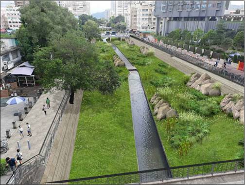
Figure 3.1
Photomontage of VP5 during Operational Phase
3.8.5
VP6 – Viewpoint of Proposed Barrage (Figure 3.2) The viewpoint is located from Long Ping Station,
looking North towards the nullah and Wang Lok Street.
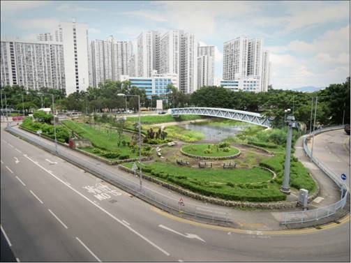
Figure 3.2
Photomontage of VP6 during Operation Phase
3.8.6
VP7 – Viewpoint from Fu Yip Street Bridge (Figure 3.3) The viewpoint is located at Fu Yip Street Bridge,
looking south, towards Long Ping MTR Station.
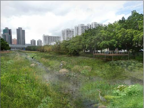
Figure 3.3 Photomontage of VP7 during Operation Phase
3.8.7
VP10 –
Viewpoint from Shan Pui Ho East Road (Figure 3.4) The viewpoint is located from Shan Pui Ho East Road,
looking towards the proposed E&M control building.
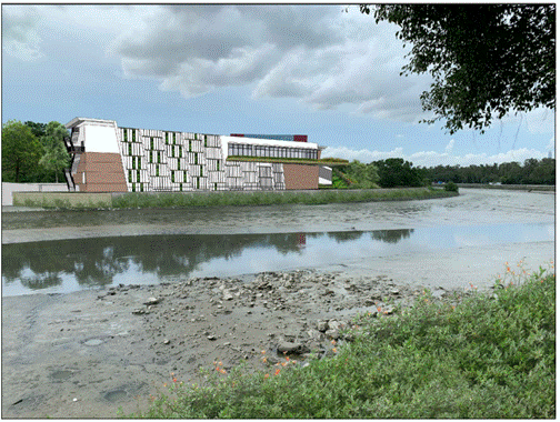
Figure 3.4 Photomontage of VP10 during Operation Phase
Kam Tin River
Parapet Modification
3.8.8
In accordance
with Annex 10 of the EIAO-TM, it is considered that the parapet modification works
will in overall terms be acceptable, that is there will be no significant
effects on the landscape and no significant visual effects or interference with
key views.
Modification of
Parapet Walls along Yuen Long Nullah, Yuen Long Bypass Floodway, and Sham Chung
River
3.8.9
In accordance
with Annex 10 of the EIAO-TM, it is considered that the parapet modification
works will in overall terms be acceptable, that is there will be no significant
effects on the landscape and no significant visual effects or interference with
key views.
4.
ENVIRONMENTAL MONITORING AND
AUDIT (EM&A) REQUIREMENT
4.1.1
Monitoring
has been recommended at designated sensitive receivers during the construction
phase of the Project. Environmental site
audit should be conducted weekly throughout the construction phase to ensure
that the proposed mitigation measures are implemented.
5.
OVERALL CONCLUSION
5.1.1
The
Project is proposed to enhance the flood protection level of the existing Yuen
Long Nullah (YLN) and Kam Tin River (KTR) and minimise the flooding risk in
accordance with DSD’s Stormwater Drainage Manual (SDM), accounting for future
development and climate change. The construction works under the Project is
anticipated to commence in Q4 of 2022 for completion by Q3 of 2029.
5.1.2
The
proposed revitalisation works under the Project would enhance the social
connectivity of YLN and its surroundings into an aesthetically-pleasing
environment. The aim is to promote water-friendliness, ecological enhancements,
biodiversity and beautification of YLN, taking into consideration of their
effects on hydraulic performance.
5.1.3
The
EIA has identified and assessed the potential environmental impacts during the
construction and operation of the Project in accordance with the requirements
set out in the EIA Study Brief (ESB-307/2018) and the EIAO-TM. The EIA has
concluded that with the implementation of the recommended mitigation measures,
no unacceptable environmental impacts are envisaged as a result of the
construction and operation of the Project and the Project would be in
compliance with the applicable environmental legislation and standards.
END OF TEXT