11.2 Environmental Legislation, Standards and Guidelines
11.6 Review on Cultural Heritage Potential
11.9 Environmental Monitoring and Audit
List of Figures
Figure 11.1 Locations
of Cultural Heritage Resources
11.
Cultural heritage impact
11.1
Introduction
11.1.1.1
This section presents the
cultural heritage impact assessment (CHIA) for the construction and operation
of the Project following the criteria and guidelines as stated in the
requirements given in Section 3.4.9 the EIA Study Brief and Annexes 10 and 19
of the EIAO-TM. Appropriate mitigation measures are recommended
as necessary.
11.2
Environmental Legislation,
Standards and Guidelines
11.2.1
General
11.2.1.1
Legislation and standards that
are relevant to the cultural heritage impact assessment under this EIA include
the following:
·
Environmental Impact Assessment
Ordinance (EIAO) (Cap.499) and Technical Memorandum on Environmental Impact
Assessment Process (EIAO-TM)
·
Guidance Note on Assessment of
Impact on Sites of Cultural Heritage in Environmental Impact Assessment Studies
·
Antiquities and Monuments
Ordinance (A&MO) (Cap.53)
·
Hong Kong Planning Standards
and Guidelines (HKPSG)
·
Guidelines for Cultural
Heritage Impact Assessment (GCHIA)
Environmental
Impact Assessment Ordinance EIAO (Cap.499) and Technical Memorandum on
Environmental Impact Assessment Process (EIAO-TM)
11.2.1.2
The EIAO stipulates that consideration must be given to issues
associated with built heritage and archaeology as part of the EIA process. Schedule 1 of the EIAO defines “Site of Cultural Heritage” as “an antiquity or
monument, whether being a place, building, site or structure or a relic, as
defined in the Antiquities and Monuments
Ordinance (Cap. 53) and any place, building, site, or structure or a relic
identified by the Antiquities and
Monuments Office (AMO) to be of archaeological, historical or paleontological
significance”.
11.2.1.3
The EIAO-TM identifies a general presumption in the favor of the
protection and conservation of all sites of cultural heritage and requires
impacts upon sites of cultural heritage to be 'kept to the absolute
minimum'. Annexes 10 and 19 of the EIAO-TM outline criteria for evaluating
the impacts on sites of cultural heritage and guidelines for impact assessment,
respectively.
Guidance
Note on Assessment of Impact on Sites of Cultural Heritage in Environmental
Impact Assessment Studies
11.2.1.4
The Guidance Note assists the understanding of the requirements of the EIAO-TM in assessing impact on sites of
cultural heritage in EIA studies
Antiquities
and Monuments Ordinance (A&MO) (Cap.53)
11.2.1.5
The Ordinance provides the statutory framework for the protection of
Declared Monuments and preservation of objects of historical, archaeological and paleontological interest. The Ordinance
contains the statutory procedures for the Declaration of Monuments. Under the Ordinance,
a “monument” means a place, building, site or
structure which is declared to be a monument, historical building or
archaeological or paleontological site or structure under Section 3 of the
Ordinance.
Hong
Kong Planning Standards and Guidelines (HKPSG)
11.2.1.6
Chapter 10 of HKPSG covers planning considerations
relevant to conservation. It also
details the principles of conservation, the conservation of natural landscape
and habitats, declared monuments, historic buildings, sites of archaeological
interest and other heritage items, and addresses the issue of enforcement. The appendices list the legislation and
administrative controls for conservation, other conservation related measures
in Hong Kong, and Government departments involved in conservation.
Guidelines
for Cultural Heritage Impact Assessment (GCHIA)
11.2.1.7
The Guidelines outline the technical requirements for conducting
cultural heritage impact assessment. The
guidelines put preservation in totality as the first priority. Mitigation measure should be proposed in
cases with identified impacts and if preservation in totality is not feasible due to site
constraints or other factors, full justification must be provided.
11.3
Assessment Methodology
11.3.1
General
11.3.1.1
The CHIA is carried out in
accordance with GCHIA, the requirements as stated in Annexes 10 and 19 of the EIAO-TM and the EIA Study Brief, as well
as considerations in other relevant guidelines.
The assessment methodology for archaeological and built heritage impact
assessments is described in the following sections.
11.3.2
Study area for this Cultural
Heritage Impact Assessment
11.3.2.1
The study area for the CHIA of
this EIA Study covers the area within 300 m from the site boundary of the
Project as illustrated in Figure 11.1.
11.3.3
Archaeology
11.3.3.1
A desktop literature review was
conducted to identify and assess the potential existence of archaeological
resources within the study area. Field
scanning was undertaken to verify the information collected and analysed, to determine the presence of archaeological
materials in the study area. Information
collected for desktop study includes the following sources:
·
AMO’s List of Sites of
Archaeological Interest;
·
Previous EIA study reports, archaeological reports and related studies
within the study area including the Preliminary Environmental Review under
Agreement No. CE 43/2011 (DS) Relocation of Sha Tin Sewage Treatment Works to
Caverns – Feasibility Study;
·
Relevant archaeological and geographical monographs; and
·
Geological and historical maps, aerial photos
and relevant visual archives.
11.3.4
Built Heritage
11.3.4.1
A desktop literature review was
conducted. The following information was
analyzed, collected and collated to determine the
presence of historical occupation in the study area and thus assess the
potential existence of cultural heritage within the potential impacted area:
·
Background information of heritage
sites (including declared monuments, proposed monuments, Government historic
sites, sites of archaeological interest and graded historic sites / buildings
identified by AMO) within and in close proximity to the study area (e.g. AMO
files, Public Records Office, map libraries, university and public libraries,
published and unpublished Government and non-Government documents, cartographic
and pictorial documents);
·
Areas proposed for construction
and operation activities and potential impacts induced by the Project;
·
Identification of previous
recorded built heritage resources within the study area which would be
supplemented by a field survey; and
·
List of the 1,444 Historic
Buildings with Assessment Results
11.3.4.2
Field survey including the
following tasks was performed:
·
Recording of identified built
heritage features;
·
Interviews with local
informants, residents and elders, if necessary. The
interviews aimed to gather information, such as cultural and historical
background of the buildings and structures, as well as historical events
associated with the built heritage features; and
·
Systematic documentation of
recorded features including:
o
A set
of 1:1000 scale maps showing the location and boundary of the cultural heritage
resources; and
o
Written
descriptions of recorded features of historic buildings, e.g. age of the
building or structure, details of architectural features, condition of the
building or structure, past and present uses, architectural appraisal, notes on
any modifications, direction faced and associations with historical or cultural
events or individuals.
11.4
Background Information
11.4.1
Geological Background
11.4.1.1
The study area is located on
the coast to the north of Sai O. A small
hill (peak elevation at +64.3 mPD) lies to the west of the study area and the
coast facing Tolo Channel in the east.
The Hong Kong Baptist Theological Seminary is located to the south of the
study area across Nin Ming Road. To
further south lies the Hunch Backs (Ngau Ngak Shan) (peak elevation at +674 mPD) inside the Ma On Shan Country Park.
11.4.1.2
The Project site is located on
the lower stream of a flood plain currently between +5.3 mPD and +3.4 mPD. The superficial deposits within the Project
site boundary is debris flow deposits (Qd on
Geological Map[1],
Plate 11.1). The small hill to the west of the study area
is composed of Mudstone and Siltstone (JTC) at the hill foot and Sedimentary
Breccia (br) on the hill top.

Plate 11.1 Geological Map of the Project area
(Source:
GCO 1986 Hong Kong Geological Survey: Shatin
Sheet 7: Solid and Superficial Geology)
11.4.2
Historical Background
Early Historical Period (Qin to Yuan
Dynasties)
11.4.2.1
Clues of human occupation within the south China can be found in
historic textual records such as Shiji (史記) and Hanshu
(漢書) written in the first century BC
and first century AD respectively. These
records described that the Yue ethnic groups (also called the Hundreds of Yue)
were scattered around in southern China.
Such ethnic groups were comprised of different tribes bearing various
surnames and can be differentiated from the Han ethnic group who lived in
central China in terms of physical characteristics, language, and folklore.
11.4.2.2
The Yue people were gradually assimilated by the
Han culture when southern China became an administrative territory of China’s
central government since Qin Dynasty (221-206 BC). During Qin period, the Guangdong was
subordinated to Panyu (番禺) County. In 208 BC, Nan Yue (Southern Yue) State was
established in Guangdong and Guangxi by military officials, who were sent from
the Qin (221-206 BC) Court to conquer the Yue in the south. Following the collapse of Qin’s political
power in the north it began Han dynasty (206BC-AD220)[2].
Nan Yue State soon became a vassal state of Han.
11.4.2.3
During Han to Eastern Jin
Dynasties (AD317-420), Hong Kong was subordinated to Bolou
(博羅) County[3].
From AD331 to AD756, Hong Kong was subordinated to Baoan
(寶安) County. After AD757, Hong Kong was subordinated to
Dongguan (東莞) County and followed by Song Dynasty (AD960-1279) and Yuan Dynasty
(1271-1368)[4]
[5].
Ming to Qing Dynasties (1368-1912)
11.4.2.4
During the 15th century, the
coastal areas of Dongguan County suffered from frequent attacks. According to Jiaxing Xin’an
Gazetteer (嘉慶新安縣誌)[6],
Xin’an County was set up in 1573 to defend attacks
from marauding bandit and pirate attacks.
The present-day New Territories, Kowloon and Hong Kong Island were zoned
within the Xin’an County as well.
11.4.2.5
In 1661, Coastal Evacuation
Order was compelled by the Qing Court in order to
stifle the anti-Manchu troops in Taiwan.
People living in the coastal area were forced to move inland 50 li (里, approximately 25 km), including the
New Territories inhabitants. It was
until 1669 when people could move back to their villages by the coast.
11.4.2.6
The villages surrounding the Project
area were recorded in the early and Middle Qing dynasty. Wu Kai Mei (烏溪尾) [the old name of Wu Kai Sha(烏溪沙)] was recorded in the Xin’an Gazatteer during the Kangxi reign (1654-1722)[7]. Sai O Tsuen (西澳村), Cheung
Muk Tau (樟木頭) and Kwun Hang Tsuen
(官坑村) were
recorded in the Gazetteers of the Jiaqing reign
(1796-1820) [8].
Modern Period
11.4.2.7
Refer to the aerial photo 1963,
the surrounding area of the Project area were mainly occupied by agricultural
field (Plate 11.2). No major changes in the land use was
identified between 1960s and 1980s. Until
1990s, the Project area was no longer agricultural field (Plate 11.3). The lands to
the south of the Project area was developed into Hong Kong Baptist Theological Seminary
by 1999 (Plate 11.4).

Plate 11.2 1963 Aerial Photo of the Project area
(Source
Lands Department 1963, 1963 aerial
photograph)

Plate 11.3 1993 Aerial Photo of the Project area
(Source
Lands Department 1993, 1993 aerial
photograph)

Plate 11.4 2001 Aerial Photo of the Project area
(Source
Lands Department 2001, 2001 aerial
photograph)
11.4.3
Archaeological Background
11.4.3.1
A site visit conducted by
members of Hong Kong Archaeological Society in 1976 at Sai O discovered an adze
with unmodified butt, a stone waste flake and a
prehistoric stoneware with double-F pattern.
However, subsequent visit by the AMO in 1979 did not recover any
finds. The First Territory Wide
Archaeological Survey covered Sai O between 1982 and 1984, which discovered no
artefacts. They concluded that it was
unlikely to recover any in situ and
undisturbed archaeological deposit would have survived the formation of the
agricultural terraces, and the erosion of the hillslopes[9].
11.5
Baseline Condition
11.5.1
Baseline Condition of Cultural
Heritage Resources
11.5.1.1
No Site of Archaeological
Interest (SAI) is located in the study area. Che Ha SAI is the closest to the Project
area, which is approximately 400 m away from the Project boundary.
11.5.1.2
No Declared Monument, Graded
Historic Building or Government Historic Site identified by AMO is located
within the study area. The closest built
heritage resource is Chat Shing Temple (七聖古廟), which is a nil grade building located at
about 550 m away from the Project area outside the study area. The locations of Che Ha SAI and Chat Shing
Temple are indicated in Figure 11.1.
11.5.2
Field Scanning Results
Archaeology
11.5.2.1
According to a field visit
conducted in August 2016, the Project area was fenced off and became a
construction site (Plate 11.5). Site formation works were being undertaken within
the Project area. Vegetation was cleared
by the site formation works and the original landscape may be reformed.

Plate 11.5 Project
area (Facing Southwest)
11.5.2.2
As the Project area was then
being used as a construction site during the field visit in August 2016,
archaeological field scanning was unable to be carried out. However, it was observed that site formation
works, including soil removal and cut-and-fill process, were carried out within
the Project area, that possible archaeological remains (if any) may be
disturbed and destroyed.
Built
Heritage
11.5.2.3
No built heritage was
identified within the study area.
11.5.2.4
Two villages – Sai O Tsuen at
the south and Nai Chung Old Village at the east of the Project boundary – were
situated within the 300 m study area. No
listed built heritage was situated in Sai O Tsuen or Nai Chung Old Village. During the field visit, no potential built
heritage resources were identified. The
residential buildings in Sai O Tsuen and Nai Chung Old Village were modern
buildings (Plates 11.6 and 11.7) that no built heritage resource
is identified.

Plate 11.6 Modern Buildings in Sai O
Tsuen
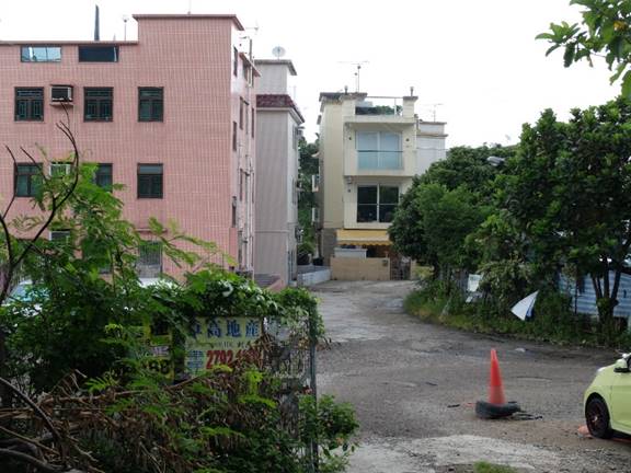
Plate 11.7 Main Entrance and the
Modern Buildings in Nai Chung Old Village
11.6
Review on Cultural Heritage
Potential
Archaeology
11.6.1.1
While many prehistoric sites in
Hong Kong were located on debris flow deposits, Sai O only contained a sheer
amount of artefact that is too few to discern any significance in it[10].
11.6.1.2
In particular, the site has
undergone site formation that transformed it from terraced fields into urban
landscapes. It is therefore very
unlikely to discover archaeological materials in the site.
11.6.1.3
It was observed from field
visit that the Project site was then under site formation works. Such works could further disturb and destroy the
archaeological remains (if any) in the site.
11.6.1.4
In the light of this, the Project
area contains no archaeological potential.
Built
Heritage
11.6.1.5
No historical village / built
heritage is identified within the Project area.
Sai O Tsuen and Nai Chung are located within the 300 m study area of the
Project site but no built heritage resources were identified from the villages during
field visit. Given that no built heritage
resource is identified within the Project area or study area, and the built
heritage resource located closest to the Project site is situated at about 550 m
away at Kwun Hang, no built heritage issue is identified.
11.7
Impact Assessment
11.7.1.1
As the site does not fall
within any SAI and contained no archaeological potential, no impact to
archaeology is anticipated.
11.7.1.2
On the other hand, no built
heritage resource is identified within the Project site or study area, thus no
impact to built heritage resources is anticipated.
11.8
Mitigation Measures
11.8.1.1
As mentioned above, no cultural
heritage impact is identified, no mitigation measures are required during the
construction or operational phase of the Project.
11.9
Environmental Monitoring and
Audit
11.9.1.1
Since no cultural heritage impact
is anticipated, no EM&A is required during construction or operational
phase of the Project.
11.10
Conclusion
11.10.1.1
This CHIA has assessed baseline
conditions and potential impacts on cultural heritage resources within the study
area of the Project. No archaeological
potential or built heritage resources were identified within the study area. No cultural heritage impact is anticipated
and thus no mitigation measures are required.
11.11
Bibliography
Geotechnical Control Office (1986) Hong Kong
Geological Survey Shatin (Sheet 7) Solid and Superficial Geology 1:20 000. Hong
Kong Government.
Peacock, B.A.V. and T.J.P. Nixon (1986) Report of
the Hong Kong Archaeological Survey Volume III Part 1 Summary Site Data Sheets.
Hong Kong AMO Unpublished Archives.
司馬遷 (約公元前91年)《史記 卷113 南越列傳》,載於維基文庫網頁 https://zh.wikisource.org/zh-hant/史記/卷113 accessed in June 2016.
舒懋官 (1819)《嘉慶新安縣志》,輯於 張一兵 2006 編《深圳舊誌三種》,深圳,海天出版社 。
靳文謨 (1688)《康熙新安縣志》,輯於 張一兵 2006 編《深圳舊誌三種》,深圳,海天出版社 。
蕭國健 (2006) 《香港古代史》,香港,中華書局。