|
Agreement
No. CE 72/2019 (EP) Environmental Monitoring and Audit (EM&A) Manual
for the New Contaminated Sediment Disposal Facility to the West of Lamma
Island
July 2022 |
CONTENTS
1.1...... Purpose of the Manual
1.2...... Project Background and Description
1.4...... Organisation & Structure of the EM&A
1.4.1..... Roles & Responsibilities
1.5...... Structure of the EM&A Manual
2....... Water and Sediment Quality
2.2...... Monitoring Activities
2.3...... Marine Water Quality Monitoring
2.3.1..... Monitoring Locations
2.3.2..... Monitoring Equipment
2.3.3..... Monitoring Parameters
2.3.4..... General Monitoring Requirements
2.3.5..... Specific Monitoring Methodology
2.3.6..... Water Quality Compliance
2.4...... Marine Sediment Quality Monitoring
2.4.1..... Monitoring Locations
2.4.2..... Monitoring Parameters
2.4.3..... General Monitoring Requirements
2.4.4..... Specific Monitoring Methodology
2.4.5..... Sediment Quality Compliance
3.2...... Objective of Benthic Recolonisation Monitoring
3.4...... Monitoring Design and Frequency
3.5...... Monitoring Methodology
3.5.1..... Monitoring Parameters
3.5.2..... Laboratory Analyses
3.5.3..... Quality Assurance & Control (QA&QC) Procedure
4.2...... Objectives of the Fisheries Resources Monitoring and Biomonitoring Programme. 26
4.4.2..... Fisheries Resource Monitoring
4.4.3..... Biomonitoring Programme
10..... Environmental Site Inspection
10.2.... Compliance with Legal & Contractual Requirements
10.3.... Environmental Complaints
11.2.... Baseline Monitoring Report
11.3.1... Contents of Monthly EM&A Report
11.4.... Quarterly EM&A Summary Report
11.5.... Annual EM&A Review Reports
11.8.... Interim Notifications of Environmental Quality Limit Exceedances
List of Tables
Table 1.1 Tentative Programme of the Project (Indicative for the first three CMPs)
Table 2.1 Coordinates of Marine Water Quality Monitoring
Table 2.2 Monitoring Parameters for Marine Water Quality Monitoring
Table 2.3 Action and Limit Levels for Water Quality
Table 2.4 Event and Action Plan for Marine Water Quality Monitoring
Table 2.5 Coordinates of Marine Sediment Quality Monitoring
Table 2.6 Monitoring Parameters for Marine Sediment Quality Monitoring
Table 2.7 Quality Control Acceptance Criteria for Organics Analyses
Table 3.1 Coordinates of Benthic Recolonisation Monitoring
Table 4.1 Coordinates of Fisheries Resources Monitoring
Table 4.2 List of Target Species for Tissue Analysis
Table 4.3 Methodology for Pooling Samples to Obtain Sufficient Tissue
List of Figures
Figure 1.1.... Preliminary Layout of the CMPs of the Project
Figure 1.2.... Indicative Project Organisation
Figure 2.1.... Locations of Marine Water Quality Monitoring
Figure 2.2.... Locations of Marine Sediment Quality Monitoring
Figure 3.1.... Locations of Benthic Recolonisation Monitoring
Figure 4.1.... Locations of Fisheries Resources Monitoring
Figure 10.1.. Flow Chart for Handling Environmental Complaint
Annexes
Annex A Implementation Schedule
Annex B Proforma for EM&A Programme
Annex C Human Health Risk Assessment Methodology
1.
Introduction
1.1
Purpose of the Manual
This Environmental Monitoring and Audit (EM&A) Manual (“the Manual”) is a supplementary document to the Environmental Impact Assessment (EIA) Report of the New Contaminated Sediment Disposal Facility to the West of Lamma Island (“the Project”). The Manual has been prepared in accordance with the EIA Study Brief (No. ESB-328/2019) and the Technical Memorandum on Environmental Impact Assessment Process (EIAO-TM). The purpose of the Manual is to provide information, guidance and instruction to personnel charged with environmental duties and those responsible for undertaking EM&A work during the construction and operation activities of the Project. It provides systematic procedures for monitoring and auditing the environmental performance of the Project. This EM&A Manual would be further reviewed and updated during the lifetime of the Project where necessary.
1.2
Project
Background and Description
Since 1992, the Civil Engineering and Development Department (CEDD) of the Hong Kong Special Administrative Region (HKSAR) Government has been managing a number of contaminated sediment disposal facilities in the Hong Kong waters, including the contaminated mud pits (CMPs) to the east of Sha Chau (ESC) and the south of The Brothers (SB). These facilities consist of some series of seabed pits, formed by the removal of existing marine sediments, for disposal of contaminated dredged/ excavated sediment generated from works within Hong Kong. When their designed capacities have been reached, the pits would be sealed off from the adjoining environment by a layer of uncontaminated sediment (or naturally excavated materials) of no less than 3 m thick. Operations at these facilities are monitored through the implementation of a purposely designed environmental monitoring and auditing programme, comprising monitoring of water quality, sediment quality, sediment toxicity, marine biota, human health and ecological risk and benthic recolonisation. Monitoring results for the existing CMPs at ESC and SB reveal that operations at these facilities are environmentally acceptable.
According to the latest estimate by CEDD, the total remaining capacity of the existing disposal facilities at ESC can only cope with the demand up to 2027 for the disposal of contaminated sediment generated from routine harbour / channel / river maintenance dredging works and future projects. The existing CMPs cannot be expanded further due to the limited usable seabed in the vicinity based on the findings of two previous studies (under (i) Agreement No. CE 105/98 – Strategic Assessment and Site Selection Study for Contaminated Mud Disposal and (ii) Agreement No. CE 12/2002 (EP) – Detailed Site Selection Study for a Proposed Contaminated Mud Disposal Facility within the Airport East/East of Sha Chau Area). A new sediment disposal facility has to be planned for in order to meet the sediment disposal demand after 2027 arising from routine harbour / channel / river maintenance dredging works and other projects.
The Project aims to plan and design the new contaminated sediment disposal facility at the west of Lamma Island (WL Facility). The proposed WL Facility aims to meet the sediment disposal demand upon the anticipated exhaustion of the existing CMPs at ESC in 2027. The Project consists of CMPs to be formed and used one by one taking into consideration of the latest forecasted demand of sediment disposal. The preliminary layout of the CMPs for the Project is presented in Figure 1.1.
The construction and operation activities of the Project include the following:
Construction activities:
n Dredging of the seabed for the formation of CMP
Operation activities:
n Disposal of contaminated sediment in the formed CMP
n Capping of the exhausted CMP by uncontaminated sediment up to the original seabed level
1.3
Project
Programme
The first CMP of the Project is planned to start construction in 2024 for operation by 2025/2026, allowing a transitional period of about two years before the anticipated exhaustion of the existing CMPs at ESC in 2027. Such transitional period is allowed to cater for possible surge of disposal demand which may expedite the exhaustion of existing CMPs and any unforeseeable interruption to the project progress. An uninterrupted disposal service could therefore be maintained. The actual disposal demand will depend on the future need for dredging due to navigation channels maintenance and construction projects which could not be ascertained at the moment. With an estimated annual average disposal demand of 0.6 Mm3 of contaminated sediments, each CMP of the proposed WL Facility is expected to provide disposal service for approximately 3 years. The tentative programme as shown in Table 1.1 demonstrates the typical construction and operation cycle for the first three CMPs of the proposed WL Facility, which covers a total period of about 10 years (including dredging, backfilling and capping). As the CMPs will be constructed and operated sequentially depending on the disposal demand, the duration for dredging, backfilling and capping of a CMP is estimated for presentation purpose only. Overall, subject to future disposal demand, the proposed WL Facility is expected to have a service lifetime for up to 20 years. The remaining CMPs are anticipated to follow a similar implementation programme for use upon exhaustion of the first three CMPs. It should be noted that no more than three CMPs will be active (dredging / backfilling / capping) at any one time.
Table 1.1 Tentative Programme of the Project (Indicative for the first three CMPs)
|
Pit |
Construction/Operation |
Year 1 |
Year 2 |
Year 3 |
Year 4 |
Year 5 |
Year 6 |
Year 7 |
Year 8 |
Year 9 |
Year 10 |
Year 11 |
Year 12 |
Year 13 |
|
1st |
Dredging |
|
|
|
|
|
|
|
|
|
|
|
|
|
|
Backfilling |
|
|
|
|
|
|
|
|
|
|
|
|
|
|
|
Capping |
|
|
|
|
|
|
|
|
|
|
|
|
|
|
|
2nd |
Dredging |
|
|
|
|
|
|
|
|
|
|
|
|
|
|
Backfilling |
|
|
|
|
|
|
|
|
|
|
|
|
|
|
|
Capping |
|
|
|
|
|
|
|
|
|
|
|
|
|
|
|
3rd |
Dredging |
|
|
|
|
|
|
|
|
|
|
|
|
|
|
Backfilling |
|
|
|
|
|
|
|
|
|
|
|
|
|
|
|
Capping |
|
|
|
|
|
|
|
|
|
|
|
|
|
1.4
Organisation
& Structure of the EM&A
The EM&A will require the involvement of the Project Proponent (CEDD), EPD, Environmental Team (ET), Independent Environmental Checker (IEC) and the Contractor(s). The indicative Project organisation is presented in Figure 1.2. The roles and responsibilities of the various parties involved in the EM&A process are further expanded in the following sections.
Figure 1.2
Indicative Project Organisation
|
|
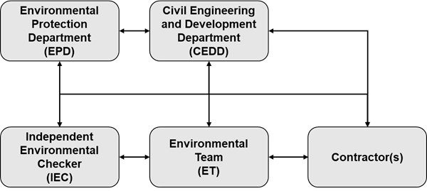
EPD is the statutory enforcement body for environmental protection matters in Hong Kong. CEDD as the Project Proponent will appoint ET to conduct the site inspection and monitoring and, to provide specialist advice on the undertaking and implementation of environmental responsibilities. The ET will be led and managed by the ET Leader (ETL). The ETL should be a person who has at least 7 years of experience in EM&A or environmental management. Suitably qualified staff will be included in the ET, and the ET should not be in any way an associated body of the Contractor(s) for the Project. For the purpose of this Manual, the ETL, who will be responsible for, and in charge of, the ET, is referred to as the person delegated the role of executing the EM&A requirements.
To maintain strict control of the EM&A process, the Project Proponent will appoint independent environmental professional to act as IEC to verify and validate/ audit the environmental performance of the Project Proponent’ contractor(s) for the Project and effectiveness of ET. The IEC should not be in any way an associated body of the Project Proponent, the Contractor(s) or the ET for the Project. The IEC should be a person who has at least 7 years of experience in EM&A or environmental management.
1.4.1 Roles & Responsibilities
The Project Proponent will:
n employ ET as described above;
n employ IEC as described above;
n supervise the Contractor(s)’ activities and confirm that the requirements in the EM&A Manual are fully complied with;
n inform the Contractor(s) when action is required to reduce impacts in accordance with the Event and Action Plans;
n adhere to the procedures for carrying out complaint investigation; and
n participate in joint site inspections undertaken by the ET and IEC.
The Contractor(s) for the Project will:
n implement the EIA recommendations and requirements where applicable;
n provide assistance to the ET in carrying out monitoring and site inspections;
n submit proposals on mitigation measures in case of exceedances of Action and Limit levels in accordance with the Event and Action Plans;
n implement measures to reduce impact where Action and Limit levels are exceeded;
n implement the corrective actions instructed by the Project Proponent/ET/IEC;
n participate in the site inspections undertaken by the ET and the IEC, as required, and undertake any corrective actions instructed by the Project Proponent/ET/IEC; and
n adhere to the procedures for carrying out complaint investigation.
The ET will:
n monitor various environmental parameters as required in this EM&A Manual;
n assess the EM&A data and review the success of the EM&A programme determining the adequacy of the mitigation measures implemented and the validity of the EIA predictions as well as identify any adverse environmental impacts before they arise;
n carry out regular site inspection to investigate the Contractor(s)’s site practice, equipment and work methodologies with respect to pollution control and environmental mitigation, and effect proactive action to pre-empt issues;
n review the Contractor(s)’s working programme and methodology, and comment as necessary;
n review and prepare reports on the environmental monitoring data and site environmental conditions;
n report on the environmental monitoring results and conditions to the IEC, Contractor(s), EPD and the Project Proponent;
n recommend suitable mitigation measures and/or review the proposals of mitigation measure from the Contractor(s) in the case of exceedance of Action and Limit levels in accordance with the Event and Action Plans; and
n adhere to the procedures for carrying out complaint investigation.
The IEC will:
n review and audit the implementation of the EM&A programme and the overall level of environmental performance being achieved;
n arrange and conduct regular independent site audits of the works;
n validate and confirm the accuracy of monitoring results, monitoring equipment, monitoring stations, monitoring procedures and locations of sensitive receivers;
n audit the EIA recommendations and requirements against the status of implementation of environmental protection measures on site;
n on an as needed basis, audit the Contractor(s)’s construction methodology and agree the appropriate, reduced impact alternative in consultation with the Project Proponent, the ET and the Contractor(s);
n adhere to the procedures for carrying out complaint investigation;
n review the effectiveness of environmental mitigation measures and project environmental performance including the proposed corrective measures;
n review EM&A report submitted by the ETL and feedback audit results to ET by signing off relevant EM&A proformas; and
n report the findings of site audits and other environmental performance reviews to the Project Proponent, ET, EPD and the Contractor(s).
1.5
Structure
of the EM&A Manual
The remainder of the Manual is set out as follows:
n Section 2 sets out the EM&A requirements for water and sediment quality;
n Section 3 sets out the EM&A requirements for marine ecology;
n Section 4 sets out the EM&A requirements for fisheries;
n Section 5 details the EM&A requirements for waste management;
n Section 6 details the EM&A requirements for cultural heritage;
n Section 7 details the EM&A requirements for human health risk;
n Section 8 sets out the EM&A requirements for air quality;
n Section 9 sets out the EM&A requirements for noise;
n Section 10 describes the scope and frequency of site environmental inspection;
n Section 11 details the reporting requirements for the EM&A;
n Annex A contains the implementation schedule summarising all mitigation measures proposed in the EIA Report; and
n Annex B contains the proforma for the EM&A programme, including monitoring and complaint log sheets.
2.
Water and Sediment Quality
2.1
Introduction
A number of mitigation measures and standard site practice measures for construction and operation activities of the Project have been recommended to reduce potential impacts to water quality sensitive receivers (WSRs). These measures are summarised in the Implementation Schedule provided in Annex A.
In accordance with the recommendations of the EIA, marine water quality monitoring at selected WSRs is recommended for marine dredging, backfilling and capping of the Project. Sediment quality monitoring is also recommended for backfilling of the CMPs. The following sections provide details of the water and sediment quality monitoring to be undertaken by the ET to detect any deterioration of water and sediment quality, and indirect impacts at water, ecological and fisheries sensitive receivers. The water quality and sediment monitoring programme will be carried out to allow any deteriorating water and sediment quality to be readily detected and timely action taken to rectify the situation. The status and locations of water quality sensitive receivers and the monitoring sites may change after issuing this Manual. If such cases exist, the ET in consultation with the IEC will propose updated monitoring locations and seek approval from EPD.
When alternative monitoring locations are proposed, they shall be chosen based on the following criteria:
§ at locations close to and preferably at the boundary of the site activities as indicated in the EIA Report, which are likely to have water quality impacts;
§ close to the sensitive receptors which are directly or likely to be affected;
§ for monitoring locations located in the vicinity of the sensitive receptors, care should be taken to cause minimal disturbance during monitoring; and
§ control stations which are at locations representative of the project site in its undisturbed condition.
2.2
Monitoring
Activities
The proposed water and sediment quality monitoring for the Project can be divided into the followings and each of these is discussed below:
Marine Water Quality Monitoring
n Baseline marine water quality monitoring before construction and operation of the Project – to gather representative water quality data in the vicinity of the Project area and adjacent reference areas in Southern Water Control Zone (WCZ) for the establishment of Action and Limit Levels of the EM&A prior to the commencement of the Project and to demonstrate the suitability of the proposed control monitoring stations;
n Marine water quality monitoring for dredging activities during formation of CMP – to monitor water quality in the vicinity of the active CMPs and representative WSRs and to investigate whether any impacts to water quality are occurring due to the dredging activities from the active CMPs; and
n Marine water quality monitoring for backfilling and capping activities during operation of CMP – to monitor water quality in the vicinity of the active CMPs and representative WSRs and to investigate whether any impacts to water quality are occurring due to the dispersion of contaminants/ sediments from the active CMPs.
Marine Sediment Quality Monitoring
n Marine routine sediment quality monitoring for backfilling activities during operation of CMP – to monitor sediment quality in the vicinity of the active CMPs and far-field areas of Southern WCZ and to investigate whether any impacts to marine sediments are occurring due to the dispersion of contaminants from the active CMPs; and
n Marine sediment quality monitoring after major storm events during operation of CMP – to monitor sediment quality after major storm events in the vicinity of the active CMPs and far-field areas of Southern WCZ and to investigate whether there is any potential dispersion of contaminants from the active CMPs after major storm.
2.3
Marine
Water Quality Monitoring
2.3.1 Monitoring Locations
Locations of the monitoring stations of the three types of marine water quality monitoring are presented in Figure 2.1 and the coordinates are shown in Table 2.1.
Table 2.1 Coordinates of Marine Water Quality Monitoring
|
Monitoring Stations |
Easting |
Northing |
Baseline |
Dredging Activities |
Backfilling and Capping Activities |
|
Control / Reference Stations |
|||||
|
CE |
828568 |
812062 |
ü |
ü |
ü |
|
CF |
828936 |
803002 |
ü |
ü |
ü |
|
Near Pit Stations |
|||||
|
NP1 |
826025 |
808927 |
ü |
ü |
ü |
|
NP2 |
826582 |
808045 |
ü |
ü |
ü |
|
NP3 |
826179 |
807086 |
ü |
ü |
ü |
|
NP4 |
825565 |
807086 |
ü |
ü |
ü |
|
NP5 |
825335 |
808064 |
ü |
ü |
ü |
|
Mid Field Stations |
|||||
|
MF1 |
827315 |
809643 |
ü |
ü |
ü |
|
MF2 |
828036 |
807634 |
ü |
ü |
ü |
|
MF3 |
823643 |
808416 |
ü |
ü |
ü |
|
MF4 |
824275 |
810539 |
ü |
ü |
ü |
|
Water Sensitive Receiver Stations |
|||||
|
WSR1 (Corals at Shek Kok Tsui) |
828415 |
810660 |
ü |
ü |
ü |
|
WSR2 (Corals at Ha Mei Wan) |
830088 |
807414 |
ü |
ü |
ü |
|
WSR3 (Potential South Lamma Marine Park) |
828883 |
805110 |
ü |
ü |
ü |
|
WSR4 (Corals at Cheung Chau) |
822168 |
808024 |
ü |
ü |
ü |
|
WSR5 (Corals at Cheung Chau) |
821981 |
809033 |
ü |
ü |
ü |
|
WSR6 (Corals at Hei Ling Chau) |
822507 |
811252 |
ü |
ü |
ü |
|
Note: Coordinates are based on HK1980 Grid Coordinate System |
|||||
2.3.2 Monitoring Equipment
For water quality monitoring, the following equipment will be used:
n Dissolved Oxygen and Temperature Measuring Equipment - The instrument will be a portable, weatherproof dissolved oxygen measuring instrument complete with cable, sensor, comprehensive operation manuals, and will be operable from a DC power source. It will be capable of measuring: dissolved oxygen levels in the range of 0 - 20 mg L-1 and 0 - 200% saturation; and a temperature of 0 - 45 degrees Celsius. It will have a membrane electrode with automatic temperature compensation complete with a cable of not less than 35m in length. Sufficient stocks of spare electrodes and cables will be available for replacement where necessary.
n Turbidity Measurement Equipment - The instrument will be a portable, weatherproof turbidity-measuring unit complete with cable, sensor and comprehensive operation manuals. The equipment will be operated from a DC power source, it will have a photoelectric sensor capable of measuring turbidity between 0 - 1000NTU and will be complete with a cable with at least 35m in length.
n pH Measurement Instrument - A portable pH meter capable of measuring a range between 0.0 and 14.0 will be provided for measuring pH.
n Salinity Measurement Instrument - A portable salinometer capable of measuring salinity in the range of 0 - 40‰ will be provided for measuring salinity of the water at each monitoring location.
n Water Depth Gauge – A portable, battery-operated echo sounder will be used for the determination of water depth at each designated monitoring station. This unit will preferably be affixed to the bottom of the work boat if the same vessel is to be used throughout the monitoring programme.
n Current Velocity and Direction – Acoustic Doppler Current Profilers (ADCP) will be used for measuring the current velocity and direction.
n Positioning Device – A hand-held Global Positioning System (GPS) or boat-fixed type differential Global Positioning System (dGPS) with way point bearing indication or other equivalent instrument of similar accuracy will be used to check that the monitoring vessel is at the correct location before taking measurements.
n Water Sampling Equipment - A water sampler, consisting of a PVC or glass cylinder of not less than two litres, which can be effectively sealed with cups at both ends, will be used. The water sampler will have a positive latching system to keep it open and prevent premature closure until released by a messenger when the sampler is at the selected water depth. A rosette multibottle (each bottle with no less than two litres volume) array water sampler could be used for the monitoring. With the use of this equipment, the sonde for measuring in situ water quality parameters could be attached together and the closure of each water sampler could be controlled remotely at the required sampling depth without the need to release messenger physically. This could enhance safety of the water quality monitoring especially at offshore locations where the sea condition could be rough.
2.3.3 Monitoring Parameters
The monitoring parameters as presented in Table 2.2 should be measured for each of the three types of marine water quality monitoring.
Table 2.2 Monitoring Parameters for Marine Water Quality Monitoring
|
Parameters |
Standard Method |
Detection Limit |
Baseline |
Dredging Activities |
Backfilling and Capping Activities |
|
|
In-situ Parameters |
|
|
|
|
||
|
Dissolved oxygen (mg L-1) |
Instrumental, CTD |
0.1 |
ü |
ü |
ü |
|
|
Temperature (°C) |
Instrumental, CTD |
0.1 |
ü |
ü |
ü |
|
|
pH |
Instrumental, CTD |
0.1 |
ü |
ü |
ü |
|
|
Turbidity (NTU) |
Instrumental, CTD |
0.1 |
ü |
ü |
ü |
|
|
Salinity (ppt) |
Instrumental, CTD |
0.1 |
ü |
ü |
ü |
|
|
Current Velocity (ms-1) |
ADCP |
0.1 |
ü |
ü |
ü |
|
|
Current Direction (deg) |
ADCP |
1 |
ü |
ü |
ü |
|
|
Laboratory Analysis |
|
|
|
|
||
|
Suspended Solids (SS) (mg L-1) |
APHA 2540D |
1.0 |
ü |
ü |
ü |
|
|
Ammonia
(NH3) |
By calculation (APHA 22ed 4500-NO2- B (FIA), APHA 22ed 4500-NO3- I(FIA), ASTM D3590-11 B (FIA)) |
0.02 |
ü |
|
ü |
|
|
Total
Inorganic Nitrogen (TIN) |
0.02 |
ü |
|
ü |
|
|
|
5-Day Biochemical Oxygen Demand (BOD5) (mg L-1) |
APHA 5210b |
0.1 |
ü |
|
ü |
|
|
Cadmium (µg L-1) |
USEPA 6020A |
1.0 |
ü |
|
ü |
|
|
Chromium (µg L-1) |
USEPA 6020A |
1.0 |
ü |
|
ü |
|
|
Copper (µg L-1) |
USEPA 6020A |
1.0 |
ü |
|
ü |
|
|
Mercury (µg L-1) |
USEPA 6020A |
1.0 |
ü |
|
ü |
|
|
Nickel (µg L-1) |
USEPA 6020A |
1.0 |
ü |
|
ü |
|
|
Lead (µg L-1) |
USEPA 6020A |
1.0 |
ü |
|
ü |
|
|
Silver (µg L-1) |
USEPA 6020A |
1.0 |
ü |
|
ü |
|
|
Zinc (µg L-1) |
USEPA 6020A |
1.0 |
ü |
|
ü |
|
|
Arsenic (µg L-1) |
USEPA 6020A |
1.0 |
ü |
|
ü |
|
|
Note: If necessary, alternative analytical method for the above parameters can be proposed for agreement by IEC. |
||||||
In addition to the water quality parameters, other relevant data will also be measured and recorded in water quality monitoring logs, including the location of the monitoring stations, water depth, time, weather conditions, sea conditions, tidal state, current direction and velocity, special phenomena and work activities undertaken around the monitoring and works area that may influence the monitoring results. A sample data record sheet is shown in Annex B for reference.
2.3.4 General Monitoring Requirements
The following general monitoring requirements are applicable to all the three types of marine water quality monitoring.
2.3.4.1 Sampling / Testing Protocols
Monitoring works will be normally completed within a 4-hour window of 2 hours before or after mid-flood and mid-ebb tides. The interval between two sets of monitoring shall not be less than 36 hours.
Each station will be sampled and measurements will be taken at three depths, 1 m below the sea surface, mid depth and 1 m above the seabed. Where the water depth is less than 6 m the mid-depth station may be omitted. If the water depth is less than 3 m, only the mid-depth station will be monitored.
For in situ measurements, duplicate measurements shall be made at each water depth at each station. Duplicate water samples shall be collected at each water depth at each station for laboratory measurements.
In situ monitoring equipment for the measurement of temperature, dissolved oxygen, turbidity, pH and salinity will be checked, calibrated and certified by a laboratory accredited under the Hong Kong Laboratory Accreditation Scheme (HOKLAS) or any other international accreditation scheme before use. The in situ monitoring equipment for the measurement of temperature, dissolved oxygen, turbidity, pH and salinity will be subsequently re-calibrated every three months throughout the stages of the water quality monitoring. Responses of sensors and electrodes will be checked with certified standard solutions before each use. Wet bulb calibration for dissolved oxygen meter will be carried out before commencement of monitoring and after completion of all measurements each day.
The monitoring team will record all data from in situ testing and from any analysis carried out on the boat in a field log. All samples will be identified with a unique date/ time/ location/ depth/ sample type code which will be attached to the sample container or written in indelible ink directly on the container. In order to avoid contamination of the samples, all containers will be new and unused and of analytical grade quality. Sources of contamination will be isolated from the working area (for example, vessel fuel and exhaust fames) and any sample contaminated by local material (such as printed circuit boards) will be discarded and the sampling repeated. Low level metal analysis in seawater is easily contaminated through inappropriate handling and sampling techniques. Site staff involved in seawater sample collection intended for dissolved metal analysis will ensure that they wear non-contaminating disposable gloves if they have previously been operating or have handled metallic equipment.
On-site calibration of field equipment will follow the “Guide to On-Site Test Methods for the Analysis of Waters”, BS 1427: 2009. Sufficient stocks of spare parts will be maintained for replacements when necessary. Backup monitoring equipment will also be made available so that monitoring can proceed uninterrupted even when equipment is under maintenance, calibration etc.
Water samples for laboratory measurement will be collected in high density polythene bottles or other suitable containers as advised by the HOKLAS accredited laboratory, packed in ice (cooled to 4° C without being frozen), and delivered to a HOKLAS laboratory as soon as possible after collection.
2.3.4.2 Laboratory Measurement and Analysis
All laboratory work shall be carried out in a HOKLAS accredited laboratory. Sufficient volume of each water sample shall be collected at the monitoring stations for carrying out the laboratory analyses. Using chain of custody forms, collected water samples will be transferred to an HOKLAS accredited laboratory for immediate processing. The determination work for SS, TIN and BOD5 shall start within 24 hours after collection of the water samples. Analytical methodology and sample preservation of monitoring parameters will be based on the latest edition of Standard Methods for the Examination of Waste and Wastewater published by American Public Health Association (APHA), American Water Works Association (AWWA) and methods by USEPA, or suitable method in accordance with requirements of HOKLAS or another internationally accredited scheme. The submitted information should include pre-treatment procedures, instrument use, Quality Assurance/Quality Control (QA/QC) details (such as blank, spike recovery, number of duplicate samples per-batch etc.), detection limits and accuracy. The QA/QC details shall be in accordance with requirements of HOKLAS or another internationally accredited scheme.
2.3.4.3 Data Quality Objectives
In-situ data
As the QA/QC procedures for the in-situ measurement of DO and Turbidity, where the difference in value between the first and subsequent measurements at a certain depth is more than 25% of the value of the first measurement, the measurements should be discarded and further measurements should be taken to confirm the values.
Inorganic Analyses
Precision
Duplicates (1 in every 20 samples) will be used to monitor the precision of the analysis. Results should be flagged for reference when:
n In water samples, for metals with a concentration >4x Method Detection Limit (MDL), the duplicate results have more than a 15% Relative Percentage Deviation (RPD)
n For all analytes with concentration <4x MDL, the duplicate results will be reported as analysed and no bounds should be quoted.
Accuracy
Standard and certified reference material (CRM) will be used to monitor accuracy and precision within and between batches: Results should be flagged for reference if:
n The variation of the standard from its true value is more than ± 15% (for mercury: ± 20%)
Recovery
Post digest spikes will be used to determine the recovery of determinants in complex sample matrices. Results should be rejected if:
n Spike recoveries are more than ± 25% from the theoretical recovery for water samples. An exceptional case would be if the sample concentration is greater than four times the spike value, the spike may be disregarded.
2.3.5 Specific Monitoring Methodology
2.3.5.1 Baseline Marine Water Quality
Monitoring
The measurements shall be taken at all designated monitoring stations including control stations, at both mid-ebb and mid-flood tides for a minimum of three days per week for four weeks prior to the commencement of the construction and operation activities of the Project.
No construction activities of the Project shall be on-going in the vicinity of the stations during the baseline monitoring. The ET shall be responsible for undertaking the baseline monitoring and shall consider if baseline monitoring needs to be extended or repeated to take into account the seasonal variations in water quality, and seek agreement with the IEC and EPD. In exceptional cases when insufficient baseline monitoring data or questionable results are obtained, the ET shall seek agreement with the IEC and the EPD on an appropriate set of data to be used as baseline reference.
The baseline monitoring schedule shall be issued to the IEC and EPD at least 2 weeks before the first day of the monitoring event for agreement. The baseline water quality conditions shall be established and agreed with EPD before commencement of the construction and operation activities of the Project. EPD shall also be notified immediately for any changes in schedule.
2.3.5.2 Marine Water Quality Monitoring for
Dredging Activities
The measurements shall be taken at all designated monitoring stations including control stations, at both mid-ebb and mid-flood tides at a frequency of three days per week during dredging activities of the Project.
The monitoring efforts should be reviewed on an as-needed basis based on sufficient monitoring results (e.g. from the first three months of monitoring) to determine whether reduction of monitoring frequency can be made. Subsequent revision(s) of monitoring efforts shall be confirmed and reflected in the updated version of the EM&A Manual upon agreement with the EPD.
2.3.5.3 Marine Water Quality Monitoring for Backfilling
and Capping Activities
The measurements shall be taken at all designated monitoring stations including control / reference stations, at both mid-ebb and mid-flood tides at a frequency of once per month during backfilling and capping activities of the Project.
The monitoring efforts should be reviewed on an as-needed basis based on sufficient monitoring results (e.g. from the first year of monitoring) to determine whether reduction of monitoring frequency, reduction of monitoring parameters or reduction of sampling depths can be made. Subsequent revision(s) of monitoring efforts shall be confirmed and reflected in the updated version of the EM&A Manual upon agreement with the EPD.
2.3.6 Water Quality Compliance
Water quality monitoring for dredging, backfilling and capping activities will be evaluated against Action and Limit Levels determined from the baseline marine water quality monitoring. The key assessment parameters are dissolved oxygen (DO) and suspended solids (SS), and thus Action and Limit Levels based on the assessment criteria are identified for these. However, turbidity can also provide valuable instantaneous information on water quality and thus Action and Limit Levels are also recommended for this parameter to facilitate quick responsive action in the event of any apparent unacceptable deterioration attributable to the works. The proposed Action and Limit Levels are shown in Table 2.3. It should be noted that other monitoring parameters (e.g. nutrients, heavy metals) will be measured to establish comprehensive water quality dataset for evaluating the operational performance of the CMPs over time and thus action and limit levels for the other monitoring parameters (e.g. nutrients, heavy metals) are not established.
Action and Limit levels are used to determine whether operational modifications are necessary to mitigate impacts to water quality. In the event that the levels are exceeded, appropriate actions in Event and Action Plan (Table 2.4) should be undertaken and a review of works will be carried out by the Contractor(s).
Any noticeable change to water quality will be recorded in the EM&A reports and will be investigated and remedial actions will be undertaken to reduce impacts. Particular attention will be paid to the Contractor(s)’s implementation of the recommended mitigation measures.
Regular site inspection (see Section 10) will be conducted throughout the Project to confirm the implementation of the water pollution control measures and good site practices as recommended in Annex A.
Table 2.3 Action and Limit Levels for Water Quality
|
Parameter |
Action Level |
Limit Level |
|
Marine Water Quality Monitoring for Dredging Activities |
||
|
DO in mg L-1 a |
Surface and Middle 5th%-ile of baseline data for surface and middle layers
Bottom 5th%-ile of baseline data for bottom layer
|
Surface and Middle 4 mg L-1 or 1st%-ile of baseline for surface and middle layers
Bottom 2 mg L-1 or 1st%-ile of baseline for bottom layer
|
|
Turbidity in NTU (Depth-averaged b) c |
95th%-ile of baseline data, and 120% of the relevant control station's turbidity at the same tide of the same day
|
99th%-ile of baseline data, and 130% of the relevant control station's turbidity at the same tide of the same day |
|
SS in mg L-1 (Depth-averaged b) c |
95th%-ile of baseline data, and 120% of the relevant control station's SS at the same tide of the same day
|
99th%-ile of baseline data, and 130% of the relevant control station's SS at the same tide of the same day |
|
Marine Water Quality Monitoring for Backfilling and Capping Activities |
||
|
DO in mg L-1 a |
Surface and Middle 5th%-ile of baseline data for surface and middle layers
Bottom 5th%-ile of baseline data for bottom layer
|
Surface and Middle 4 mg L-1 or 1st%-ile of baseline for surface and middle layers
Bottom 2 mg L-1 or 1st%-ile of baseline for bottom layer
|
|
Turbidity in NTU (Depth-averaged b) c |
95th%-ile of baseline data, and 120% of the relevant control station's turbidity at the same tide of the same day
|
99th%-ile of baseline data, and 130% of the relevant control station's turbidity at the same tide of the same day |
|
SS in mg L-1 (Depth-averaged b) c |
95th%-ile of baseline data, and 120% of the relevant control station's SS at the same tide of the same day
|
99th%-ile of baseline data, and 130% of the relevant control station's SS at the same tide of the same day |
|
|
|
|
|
Notes: a. For DO, non-compliance of the water quality limits occurs when monitoring result at sensitive receiver station(s) is lower than the limits. b. “Depth-averaged” is calculated by taking the arithmetic means of reading of all three depths. c. For turbidity and SS, non-compliance of the water quality limits occurs when monitoring result at sensitive receiver station(s) is higher than the limits. |
||
Table 2.4 Event and Action Plan for Marine Water Quality Monitoring
|
Event |
Action |
|||
|
ET |
IEC |
Contractor(s) |
Project Proponent |
|
|
Action Level being exceeded by one sampling day |
1. Repeat in-situ measurement on the same sampling day to confirm findings; 2. Check monitoring data, plant, equipment and Contractor(s)’s working methods; 3. Identify source(s) of impact and record in notification of exceedance; 4. Inform IEC, Contractor(s), Project Proponent and EPD.
|
1. Check monitoring data submitted by ET and Contractor(s)’s working methods. |
1. Confirm receipt of notification of exceedance in writing; 2. Check plant and equipment and rectify unacceptable practice. |
1. Confirm receipt of notification of exceedance in writing.
|
|
Action Level being exceeded by two or more consecutive sampling days |
1. Repeat in-situ measurement on the same sampling day to confirm findings; 2. Check monitoring data, plant, equipment and Contractor(s)’s working methods; 3. Identify source(s) of impact and record in notification of exceedance; 4. Inform IEC, Contractor(s), Project Proponent and EPD; 5. Discuss with IEC and Contractor(s) on additional mitigation measures and ensure that they are implemented.
|
1. Check monitoring data submitted by ET and Contractor(s)’s working methods; 2. Discuss with ET and Contractor(s) on additional mitigation measures and advise Project Proponent accordingly; 3. Assess the effectiveness of the implemented mitigation measures.
|
1. Confirm receipt of notification of exceedance in writing; 2. Check plant and equipment and rectify unacceptable practice; 3. Consider changes of working methods; 4. Discuss with ET and IEC on additional mitigation measures and propose them to Project Proponent within 3 working days; 5. Implement the agreed mitigation measures. |
1. Confirm receipt of notification of exceedance in writing; 2. Discuss with the IEC on the proposed additional mitigation measures and agree on the mitigation measures to be implemented; 3. Ensure additional mitigation measures are properly implemented.
|
|
Limit Level being exceeded by one sampling day |
1. Repeat in-situ measurement on the same sampling day to confirm findings; 2. Check monitoring data, plant, equipment and Contractor(s)’s working methods; 3. Identify source(s) of impact and record in notification of exceedance; 4. Inform IEC, Contractor(s), Project Proponent and EPD; 5. Discuss with IEC and Contractor(s) on additional mitigation measures and ensure that they are implemented.
|
1. Check monitoring data submitted by ET and Contractor(s)’s working methods; 2. Discuss with ET and Contractor(s) on additional mitigation measures and advise Project Proponent accordingly; 3. Assess the effectiveness of the implemented mitigation measures.
|
1. Confirm receipt of notification of exceedance in writing; 2. Check plant and equipment and rectify unacceptable practice; 3. Critically review the need to change working methods; 4. Discuss with ET and IEC on additional mitigation measures and propose them to Project Proponent within 3 working days; 5. Implement the agreed mitigation measures. |
1. Confirm receipt of notification of exceedance in writing; 2. Discuss with the IEC on the proposed additional mitigation measures and agree on the mitigation measures to be implemented; 3. Ensure additional mitigation measures are properly implemented; 4. Request Contractor(s) to critically review the working methods.
|
|
Limit Level being exceeded by two or more consecutive sampling days |
1. Repeat in-situ measurement on the same sampling day to confirm findings; 2. Check monitoring data, plant, equipment and Contractor(s)’s working methods; 3. Identify source(s) of impact and record in notification of exceedance; 4. Inform IEC, Contractor(s), Project Proponent and EPD; 5. Discuss with IEC and Contractor(s) on additional mitigation measures and ensure that they are implemented.
|
1. Check monitoring data submitted by ET and Contractor(s)’s working methods; 2. Discuss with ET and Contractor(s) on additional mitigation measures and advise Project Proponent accordingly; 3. Assess the effectiveness of the implemented mitigation measures. |
1. Confirm receipt of notification of exceedance in writing; 2. Check plant and equipment and rectify unacceptable practice; 3. Critically review the need to change working methods; 4. Discuss with ET and IEC on additional mitigation measures and propose them to Project Proponent within 3 working days; 5. Implement the agreed mitigation measures; 6. As directed by Project Proponent, slow down or stop all or part of the marine works until no exceedance of Limit Level. |
1. Confirm receipt of notification of exceedance in writing; 2. Discuss with the IEC on the proposed additional mitigation measures and agree on the mitigation measures to be implemented; 3. Ensure additional mitigation measures are properly implemented; 4. Request Contractor(s) to critically review the working methods; 5. Consider and instruct, if necessary, the Contractor(s) to slow down or to stop all or part of the marine works until no exceedance of Limit Level.
|
2.4
Marine
Sediment Quality Monitoring
2.4.1
Monitoring Locations
Sediment samples should be collected from stations located in three discrete areas, namely far-field, mid-field and near-pit areas to investigate potential dispersion of contaminants from the operation of active CMPs for the two types of sediment monitoring. The proposed locations are indicated on Figure 2.2 and the coordinates are shown in Table 2.5.
Table 2.5 Coordinates of Marine Sediment Quality Monitoring
|
Monitoring Stations |
Easting |
Northing |
Routine Sediment Quality Monitoring |
Sediment Quality Monitoring after Major Storm |
|
Far Field Stations |
||||
|
SFF1 |
827677 |
810528 |
ü |
ü |
|
SFF2 |
828845 |
803077 |
ü |
ü |
|
SFF3 |
821844 |
804688 |
ü |
ü |
|
Mid Field Stations |
||||
|
SMF1 |
826033 |
809918 |
ü |
ü |
|
SMF2 |
827482 |
808164 |
ü |
ü |
|
SMF3 |
825854 |
806100 |
ü |
ü |
|
SMF4 |
823836 |
808515 |
ü |
ü |
|
Near Pit Stations |
||||
|
SNP1 |
826026 |
808938 |
ü |
ü |
|
SNP2 |
826570 |
808075 |
ü |
ü |
|
SNP3 |
826159 |
807125 |
ü |
ü |
|
SNP4 |
825563 |
807119 |
ü |
ü |
|
SNP5 |
825346 |
808113 |
ü |
ü |
|
Note: Coordinates are based on HK1980 Grid Coordinate System |
||||
2.4.2 Monitoring Parameters
The following parameters should be measured for the collected sediments. Some of the contaminants listed are the "Contaminants of Concern" for which Lower and Upper Chemical Exceedance Limits (LCEL/UCEL) exist. The parameters will be measured for the two types of sediment monitoring as summarised in Table 2.6.
n Total Organic Carbon (TOC) - an indicator of organic load and the impact on bottom layer dissolved oxygen. TOC is an important factor influencing the chemical partitioning and toxicity of hydrophobic organic compounds such as PAHs and PCBs. High TOC often infers that hydrophobic contaminants are less bioavailable;
n Inorganic Contaminants - metals and metalloids present in the disposed sediments which may be bioaccumulated;
n Polycyclic Aromatic Hydrocarbons (PAH) - a class of organic compounds some of which are persistent and carcinogenic. These compounds may be bioaccumulated and stored in the fatty body tissues of marine mammals;
n Total Polychlorinated Biphenyls (PCB) - a class of persistent man-made chemicals which tend to bioaccumulate through the food chain and can cause reproductive failure and cancer;
n Tributyltin (TBT) (in sediment and interstitial water) – moderately persistent toxic compound found in marine sediments which may be bioaccumulated and cause growth abnormalities and reproductive failure; and
n Percentage of Silt/Clay (% < 63μm) – organic contaminants and metals bind more readily to finer particles than coarser particles due to their larger surface area and consequent larger number of binding sites.
Table 2.6 Monitoring Parameters for Marine Sediment Quality Monitoring
|
Parameters |
Standard Method |
Detection Limit |
Routine Sediment Quality Monitoring |
Sediment Quality Monitoring after Major Storm |
|
TOC (mg kg-1 dry weight) |
USEPA 9060A |
100 |
ü |
ü |
|
Cadmium (mg kg-1 dry weight) |
USEPA 6020A, 7000A or 7131A |
0.2 |
ü |
ü |
|
Chromium (mg kg-1 dry weight) |
USEPA 6010C, 7000A or 7190 |
8 |
ü |
ü |
|
Copper (mg kg-1 dry weight) |
USEPA 6010C, 7000A or 7210 |
7 |
ü |
ü |
|
Mercury (mg kg-1 dry weight) |
USEPA 7471A |
0.05 |
ü |
ü |
|
Nickel (mg kg-1 dry weight) |
USEPA 6010C, 7000A or 7520 |
4 |
ü |
ü |
|
Lead (mg kg-1 dry weight) |
USEPA 6010C, 7000A or 7420 |
8 |
ü |
ü |
|
Silver (mg kg-1 dry weight) |
USEPA 6020A, 7000A or 7761 |
0.1 |
ü |
ü |
|
Zinc (mg kg-1 dry weight) |
USEPA 6010C, 7000A or 7950 |
20 |
ü |
ü |
|
Arsenic (mg kg-1 dry weight) |
USEPA 6020A, 7000A or 7061A |
1 |
ü |
ü |
|
PAH (µg kg-1 dry weight) |
USEPA 8260B or 8270C |
55 |
ü |
|
|
Total PCBs (µg kg-1 dry weight) |
USEPA 8082 |
3 |
ü |
|
|
Tributyltin (µg TBT L-1 in interstitial water) |
Krone et al. (1989) -GC/MS UNEP/IOC/IAEA |
0.015 |
ü |
|
|
Percentage of Silt/Clay (% < 63μm) |
Geospec 3:2001 Test 8.1 |
0.1 |
ü |
|
|
Note: If necessary, alternative analytical method for the above parameters can be proposed for agreement by IEC. |
||||
In addition to the sediment quality parameters, other relevant data will also be measured and recorded in monitoring logs, including the location of the monitoring stations, water depth, time, weather conditions, sea conditions, special phenomena and work activities undertaken around the monitoring and works area that may influence the monitoring results.
2.4.3 General Monitoring Requirements
2.4.3.1 Sampling Procedure and Equipment
All samples should be collected by an experienced sampling team, deployed on a survey boat equipped with fully calibrated sampling equipment and precision navigational instruments. All vessel positioning should be accomplished with a Global Positioning System (GPS), ensuring station location accuracy to < ± 5 m (95% confidence), with sample position automatically logged and mapped by the navigation computer. Where sample stations are located in close proximity to the pit area, positioning should be further validated by use of an echo sounder to detect whether the vessel is within the boundaries of the CMP.
At each sampling station the top 5 cm of seabed sediment should be collected using a 5-component cluster grab sampler which collects surface sediments with a minimal disruption to the surface layer and is designed to work effectively in soft sediment such as those found in the area. The cluster grab should be deployed once at each of the stations located within each sampling area. The grabs can be customised and a fine mesh lid added, which ensures that the fine fluid sediments on the surface of the seabed are retained in the sample. Utilisation of this cluster sampler allows a large volume of sediment to be collected in a single deployment. Other similar samplers (e.g. Petit-ponar) collect less sediment in each deployment may have difficulty in collecting adequate samples in soft sediments, such as those within the Project area, thereby reducing efficiency and increasing collection time. The five-cluster grab should be collected and combined, and the sample, labelled, double-bagged and stored in an ice chest cooled to a temperature of 4°C with ice packs. The sediment sampler and all other utensils should be rinsed with seawater after each sample has been collected to avoid cross contamination between samples. On completion of the survey, all samples should be promptly transported, in chilled containers, to the testing laboratory for analysis.
2.4.3.2 QA/QC
A broad range of contaminants should be analysed in sediment samples including metals, metalloids, PAHs, PCBs and Tributyltin in both sediment and interstitial water. Other QA/QC procedures to be implemented for marine sediment analyses include:
n Laboratory blanks - an analyte free matrix to which all reagents will be added in the same volumes or proportions as used in the standard sample preparation to monitor contamination introduced in the laboratory (organics and inorganics);
n Batch duplicates - an intra-laboratory split sample randomly selected from the sample batch to monitor method precision (intra-batch) in a given sample matrix (inorganics only);
n Certified Reference Materials - analysis of a material with a known concentration of contamination to determine the accuracy of results in a given matrix (inorganics only);
n Single Control Samples - a known, interference-free matrix spiked with target analytes used to monitor laboratory preparation techniques (organics only);
n Duplicate Control Samples - multiple single control samples designed to monitor preparation technique reproducibility (organics).
2.4.3.3 Data Quality Objectives
Data Quality Objectives (DQOs) have been developed to address precision, accuracy and analyte recovery.
Inorganic Analyses
Precision
Duplicates (1 in every 20 samples) should be used to monitoring the precision of the analysis. Results should be flagged for reference when:
n For all analytes, except metals, with concentration >4x Method Detection Limit (MDL), the duplicate results have more than a 20% Relative Percentage Deviation (RPD)
n In sediment samples, for metals with a concentration >4x MDL, the duplicate results have more than a 25% RPD
n For all analytes with concentration <4x MDL, the duplicate results should be reported as analysed and no bounds should be quoted
Accuracy
Standard and certified reference material (CRM) will be used to monitor accuracy and precision within and between batches: Results should be flagged for reference if:
n The variation of the standard from its true value is more than ± 15% (for mercury: ± 20%).
Recovery
Post digest spikes should be used to determine the recovery of determinants in complex sample matrices. Results should be rejected if:
n Spike recoveries are more than ± 25% from the theoretical recovery for waters, sediment and marine biota. An exceptional case would be if the sample concentration is greater than four times the spike value, the spike may be disregarded.
Organic Analyses
Samples should be analysed in lots of less than 20. In order to measure the laboratory performance within each batch of samples, a single control sample (SCS), a duplicate control sample (DCS) and a method blank (MB) should be processed concurrently with the samples. A SCS or DCS consists of an interference free control matrix that is spiked with a group of target compounds representative of the method analytes.
Method blanks, also known as reagent, analytical, or preparation blanks, should be analysed to assess the level of contamination that exist in the analytical system and which might lead to the reporting of elevated concentration levels or false positive data. For organic analyses, the concentration of target analytes in the blank must be below the reporting limit for that analyte in order for the blank to be considered acceptable.
Accuracy is expressed as the average percent recovery for the SCS and precision is expressed as the relative percent difference (RPD) for the DCS pair. For control limits that are not established due to insufficient data sets, the QC Acceptance Criteria of US EPA Method 8080 and 8270A should be used as a supplement. Once enough data are collected, the in-house control limits should then be calculated.
The accuracy and precision data for SCS and DCS should be evaluated against laboratory established control limits. QC results falling outside the control limits should be automatically flagged. The acceptance criterion is that 100 percent of the precision and accuracy values must fall within the control limits. If this criterion is not met, corrective action must be taken. This may include repeat sample analysis.
The average percent recovery of the SCS should be compared to the limit set for each compound being monitored (Table 2.6). For DCS, an RPD of less than 20% is deemed to be acceptable in normal instances.
For multianalyte organic tests, if greater than 20% of the accuracy or precision results for the SCS/DCS are outside of the control limits, the data are considered suspect and the samples associated with the unacceptable DCS are reprepared and/or reanalysed.
Table 2.7 Quality Control Acceptance Criteria for Organics Analyses
|
Target Analytes |
Percent Recovery Measured (%) |
|
Naphthalene |
74 - 126 |
|
Acenaphthalene |
69 - 125 |
|
Acenaphthene |
73 - 119 |
|
Fluorene |
81 - 129 |
|
Phenanthrene |
74 - 131 |
|
Anthracene |
63 - 116 |
|
Fluoranthene |
73 - 134 |
|
Pyrene |
59 - 129 |
|
Benzo(a)anthracene |
77 - 136 |
|
Chrysene |
53 - 130 |
|
Benzo(a)pyrene |
51 - 103 |
|
Dibenzo(a,h)anthracene |
78 - 126 |
|
Total PCBs |
79 - 127 |
|
Tributyltin |
80 - 115 |
|
Remark: Results must be greater than zero |
|
2.4.3.4 Statistical Treatment of Data
The design of the monitoring programme should allow ANOVA techniques to be employed. These techniques will be used to analyse the data at different spatial and temporal scales of replication. Statistical differences should be tested at the following factors: between areas and between sampling times. An advantage of this sampling design is that it removes the possibility of detecting differences simply due to inherent variation over spatial scales in the active area and thus facilitates clearer attribution to disposal operations. By replicating within each area, i.e. by sampling two stations in one area, any statistically significant differences detected between areas are more likely to be due to factors other than spatial variation (e.g. locations of disposal operations). This approach is now an internationally recommended technique for use in monitoring programmes ([1]).
2.4.4 Specific Monitoring Methodology
2.4.4.1 Marine Routine Sediment Quality
Monitoring for Backfilling Activities
Sediment samples will be collected four times per year, twice during the dry season and twice during the wet season at all stations as discussed in Section 2.4.1. Two replicates of sediment composite samples (i.e. 5 grab samples obtained using a cluster grab to form one composite sample) will be collected from each station.
The monitoring efforts will be reviewed and adjusted on an as-needed basis based on appropriate statistical tools (e.g. power analyses) for reporting in Annual EM&A Review Reports.
2.4.4.2 Marine Sediment Quality Monitoring
after Major Storm Event
The marine sediment quality monitoring after major storm event will be conducted within one week of a major storm event (Typhoon Signal Number 8 or above) in order to determine whether the pits retain disposed sediments during storms and whether there are any detectable changes in sediment quality adjacent to the pits. Two replicates of sediment composite samples (i.e. 5 grab samples obtained using a cluster grab to form one composite sample) will be collected from each station.
2.4.5 Sediment Quality Compliance
Should significant increases be detected in the level of contaminants in sediment samples over time or proximity to the active pits, a review of the monitoring data should be undertaken. This review will focus on sampling stations in the vicinity of the sediment quality monitoring stations where increases are detected to see if these can be attributed to contaminant migration from the active CMPs. Assessment of the statistical significance of the data, confidence in the data and the presence of supporting data from other components of the monitoring programme should be jointly assessed. If appropriate, biological screening (sediment toxicity test) following the protocol stated in ETWB TC(W) No. 34/2002 should be conducted at the monitoring station(s) with significant increase of contaminant concentration to investigate whether contaminated sediment placed in the active CMPs represents an ecological risk to biota in areas adjacent to the CMPs. Biological screening (sediment toxicity test) will also be conducted for uncontaminated sediments (i.e. Cat L sediments) from one far-field monitoring station (e.g. SFF1, SFF2 or SFF3) as a control. Changes to the operation plan should then be considered upon review of both sediment quality and biological screening results and reported in quarterly EM&A summary / annual EM&A review reports.
3.
Marine Ecology
3.1
Introduction
As no unacceptable impacts have been predicted to occur during construction and operation of the Project, monitoring of marine ecology during these construction and operation activities is not considered necessary.
Monitoring activities designed to detect and mitigate impacts to water quality during construction and operation activities are also expected to serve to protect against impacts to marine ecology. The details of the water quality monitoring programme are presented in this EM&A Manual (Section 2).
The recommended mitigation measures for the construction and operation activities of the Project are summarised in the Implementation Schedule provided in Annex A.
The EIA has indicated that benthic fauna are expected to recolonise the CMPs following capping with uncontaminated mud. It is expected that recolonisation of the natural benthic assemblage will occur and eventually the benthic assemblage will resemble that of the surrounding areas. Recolonisation may be achieved by larval recruitment, influx of juveniles or adults carried in water currents, or through the active swimming or crawling of individuals. However, other natural (e.g. storm events, hypoxia, salinity fluctuations) or anthropogenic (e.g. pollution, fisheries operations) activities may hinder recolonisation of capped pits. As a result, the factors contributing to the composition of the benthic assemblage may be difficult to determine. It is also important for any recolonisation studies to be aware of any cap maintenance (or "topping up") activities which may also impact the resident benthic assemblages.
In order to verify the recolonisation of benthic assemblage on the capped CMPs, a benthic recolonisation monitoring programme is recommended. The details of the EM&A programme for benthic recolonisation are presented in the following sections.
3.2
Objective
of Benthic Recolonisation Monitoring
The objective for this component of the EM&A is to monitor and report on the benthic recolonisation of the capped CMPs including the previous ones and specifically to determine the difference in infauna between the capped CMPs and adjacent reference areas.
3.3
Hypothesis
The impact hypothesis for this task is as follows:
n Recolonisation is occurring at the capped CMPs such that assemblages at the capped CMPs become more similar to reference assemblages as time since capping increases.
The null hypothesis to be tested for this work component is as follows:
H0 There is no difference in the structure of benthic infaunal assemblages found at the capped CMPs of the Project and adjacent reference areas.
3.4
Monitoring
Design and Frequency
The sampling design of this task involves two treatments: capped CMPs and reference areas. The capped CMP treatment will involve collection of samples from the capped CMPs of the Project. The second treatment will involve sampling at different reference areas, which are chosen to improve the balanced nature of the design. Using multiple controls is an effective way of ensuring that the extremely variable nature of Hong Kong's marine benthos from one site to another does not overly influence or alter the results. Current ecological theory suggests that the use of multiple control sites in sampling designs are statistically more robust and hence the conclusions are more reliable ([2]) ([3]).
The locations of Reference and Capped-pit stations are shown in Figure 3.1 and the coordinates are shown Table 3.1. Samples will be collected twice per year, once in the wet season between June and August, once during the dry season between December and February. Five replicate samples will be collected from each of the monitoring stations. Sampling at Reference and Capped-pit stations will commence once capping of first CMP of the Project is completed. It should be noted that sampling at Capped-pit stations will only be conducted at those CMP(s) where capping works have been completed. With reference to the previous EM&A programme for ESC and SB CMPs, the benthic recolonisation monitoring for each capped CMP will be conducted for 2 years. The results will be reported in quarterly EM&A summary / annual EM&A review reports for evaluation of the status of recolonisation of benthic assemblage.
The sampling frequency and number of replicates will be reviewed annually or on as needed basis using appropriate statistical tools (e.g. power analysis).
Table 3.1 Coordinates of Benthic Recolonisation Monitoring
|
Monitoring Stations |
Easting |
Northing |
|
Reference Stations |
||
|
RB1 |
827589 |
810193 |
|
RB2 |
827955 |
804993 |
|
RB3 |
822917 |
807999 |
|
Capped-pit Stations |
||
|
CP1 |
826218 |
808623 |
|
CP2 |
826253 |
808040 |
|
CP3 |
826425 |
807433 |
|
CP4 |
825891 |
807432 |
|
CP5 |
825358 |
807432 |
|
CP6 |
825644 |
808041 |
|
CP7 |
825790 |
808623 |
|
Note: Coordinates are based on HK1980 Grid Coordinate System |
||
3.5
Monitoring
Methodology
The benthic recolonisation monitoring will be conducted by benthic grab method utilising a modified Van Veen grab sampler (960 cm2 sampling area; 11,000 cm3 capacity) with a supporting frame attached to a swiveling hydraulic winch cable. Sediments for biological analysis will be sieved on board the survey vessel. The sediments will be washed into a sieve stack (comprising 1 mm2 and 500 µm2 meshes) and gently rinsed with seawater to remove all fine material. Following rinsing, any material remaining on the two screens will be combined and carefully rinsed using a minimal volume of seawater into pre-labelled thick triple-bagged ziplock plastic bags. A 5% solution of borax-buffered formalin containing Rose Bengal in seawater will then be added to the bag to ensure tissue preservation. Samples will be sealed in plastic containers for transfer to the taxonomy laboratory for sorting and identification.
3.5.1 Monitoring Parameters
The benthic sediment samples collected will be analysed for the following parameters:
n Total number of species (diversity)
n Abundance of each species recorded (biomass)
In addition to the above parameters, other relevant data will also be measured and recorded, inclusive but not limited to; time, weather conditions, sea conditions, special phenomena (if any), and other activities undertaken around the sampling locations that may influence the sampling results.
3.5.2 Laboratory Analyses
The benthic laboratory will perform sample re-screening after the samples have been held in formalin for a minimum 24 hours to ensure adequate fixation of the organisms. Individual samples from the 500 µm2 and 1 mm2 mesh sieves will be gently rinsed with fresh water into a 250 µm2 sieve to remove the formalin from the sediments. Sieves will be partially filled while rinsing a specific sample to maximize washing efficiency and prevent loss of material. All material retained on the sieve will be placed in a labeled plastic jar, covered with 70% ethanol, and lightly agitated to ensure complete mixing of the alcohol with sediments. Original labels will be retained with the re-screened sample material.
Standard and accepted techniques will be used for sorting organisms from the sediments. Small fractions of a sample will be placed in a petri dish under a 10-power magnification dissecting microscope and scanned systematically with all animals and fragments removed using forceps. Each petri dish will be sorted at least twice to ensure removal of all animals. Organisms representing major taxonomic groups, such as Polychaeta, Arthropoda, Mollusca and miscellaneous taxa will be sorted into separate, labeled vials containing 70% ethanol.
Taxonomic identifications will be performed by qualified and experienced specialist using stereo dissecting and high-power compound microscopes. These are generally to the species level except for unidentified taxa, which will be identified to genera as far as practical. The careful sampling procedure employed minimizes fragmentation of organisms. If breakage of soft-bodied organisms occurred, only anterior portions of fragments will be counted, although all fragments will be retained and weighed for biomass determinations (wet weight).
3.5.3 Quality Assurance & Control
(QA&QC) Procedure
The sediment samples will be evaluated for acceptance based upon the degree of disturbance, penetration depth, and amount of leakage from the grab. In the following cases, a sediment sample would be rejected and another sample collected:
n The sediment sampler doors open in recovery, causing possible surface washout.
n Half sample obtained where the sediment sampler had not struck a flat area of seabed, or improper deployment of benthic grab, or half sample of sediment.
n Disruption of the sample by heavy shaking or contamination (these can occur when a sample is badly handled or if the sediment sampler strikes the side of the vessel during operation).
n The sample represents less than 30% of the sediment sampler’s total capacity (i.e. less than 15 cm penetration).
n Grab deployment location deviates from the designated position ([4]).
Before sieving each sample on site, the grab, frame and sample containers will be washed with seawater to avoid cross contamination of samples.
Sample integrity for subtidal benthos analyses should be maintained for the duration of the survey, demobilization through to delivery to the appropriate laboratory. All samples should be accompanied with a Chain of Custody form to document sample management and delivery.
3.5.4 Data Analysis
Density of organisms for each grab sample will be expressed as individuals / m2. Biomass of each grab sample will be expressed in g wet weight. Diversity of organisms at each survey location will be presented as species richness, Shannon-Weiner diversity (H’) and Pielou’s evenness (J’).
Descriptive statistics for the measured parameters described above, including sum, mean value and standard deviation, will be analysed for the survey locations as appropriate. Inferential statistics (e.g. Analysis of Variance (ANOVA)) will also be conducted to compare spatial and temporal differences of the benthic grab samples.
Other relevant data and information, including sampling time, weather conditions as well as any special phenomena and activities around the survey locations that might have influenced the survey results will also be reported.
4.
Fisheries
4.1
Introduction
While no unacceptable impacts have been predicted to occur during construction and operation of the Project, monitoring of fisheries resources and biomonitoring programme are recommended to address stakeholders’ concerns on the level of fisheries resources and contamination of seafood in the vicinity of the Project.
In addition, monitoring activities designed to detect and mitigate impacts to water quality during construction and operation activities are also expected to serve to protect against impacts to fisheries. The details of the water quality monitoring programme are presented in this EM&A Manual (Section 2).
The recommended mitigation measures for the construction and operation activities of the Project are summarised in the Implementation Schedule provided in Annex A.
The details of the EM&A programme for fisheries resources monitoring and biomonitoring programme are presented in the following sections.
4.2
Objectives
of the Fisheries Resources Monitoring and Biomonitoring Programme
The objectives of the fisheries resources monitoring and biomonitoring programme are:
n Fisheries resources monitoring: To assess the impact of construction and operation activities of the Project on the fisheries resources adjacent to and remote from the Project area;
n Biomonitoring programme: To identify any increase in the concentrations of contaminants in tissues of demersal fisheries resources adjacent to and remote from the Project area during backfilling operation.
4.3
Hypothesis
The impact hypothesis is as follows:
n There is no increase in tissue contaminant concentration over time in selected target species group.
Two sets of null hypotheses to be tested are as follows:
Fisheries Resources Monitoring
H0 There are no differences in the composition or abundance of fisheries resources adjacent to and remote from the Project area.
H0 There are no differences in the composition or abundance of fisheries resources over time.
Biomonitoring Programme
H0 The concentrations of contaminants in tissue samples of fisheries resources adjacent to the Project area are not greater than contaminant concentrations from samples collected at stations remote from the Project area.
H0 The concentrations of contaminants in tissue samples of fisheries resources do not increase over time.
4.4
Monitoring
Design
4.4.1 Introduction
It is noted that trawling has been adopted in the EM&A programme for the ESC CMPs and SB CMPs which is effective in collecting demersal fisheries resources. As trawl ban in Hong Kong waters came into force on 31 December 2012, while environmental monitoring using trawlers could still be conducted by applying research fishing permit from the Agriculture, Fisheries and Conservation Department (AFCD), alternative fishing method, gill-netting, which is a common fishing method adopted by the fishing industry, is recommended for the collection of fisheries resources to minimise disturbance and damage to the seabed. The collected fisheries resources will then be sorted and selected target species will be further analysed for potential contaminants in tissue. The monitoring design and frequency for the fisheries resources monitoring and biomonitoring programme are discussed in the following sections.
4.4.2
Fisheries Resource Monitoring
Fisheries resources monitoring will be conducted four times per year during daytime (once in July and once in August of the wet season and once in January and once in February of the dry season) at three (3) survey locations adjacent to (i.e Near-Pit Stations) and three (3) survey locations remote from (i.e. Reference Stations) the Project area as shown in Figure 4.1 during construction and operation activities of the Project. The coordinates of the survey locations are presented in Table 4.1. These locations are proposed to avoid the areas of heavy marine traffic, such as near the marine vessel fairway, in order to minimise potential confounding factors which may affect the survey results and to ensure that surveys can be undertaken in a safe manner. The monitoring stations are subject to refinement taking into account marine traffic and site conditions. Actual survey locations will be recorded using global positioning system (GPS) and water depth will be measured using portable sonar system during each survey. The monitoring frequency is the same as those adopted in ESC CMP EM&A programme as a consistent and conservative approach. It will be reviewed and adjusted as and when necessary using appropriate statistical tools (e.g. power analysis).
Table 4.1 Coordinates of Fisheries Resources Monitoring
|
Monitoring Stations |
Easting |
Northing |
|
Reference Stations |
||
|
FR1 |
823594 |
809381 |
|
FR2 |
827149 |
810208 |
|
FR3 |
825870 |
805678 |
|
Near-pit Stations |
||
|
FN1 |
826612 |
808535 |
|
FN2 |
826876 |
807297 |
|
FN3 |
825537 |
806991 |
|
Note: Coordinates are based on HK1980 Grid Coordinate System |
||
Gill-netting will be used to sample fisheries resources at each survey location. Six (6) stationary bottom trammel gillnets will be deployed at each location for 3 hours. Each net will be 1.5 m in stretch depth, 30 m in length and comprised of 3 layers, with two 20 cm stretch mesh size sandwiching a 5 cm stretch mesh size. All catches, i.e. fishes, crustaceans and cephalopods, etc., will be washed and recorded immediately and will be identified to species level as far as practicable. All samples should then be chilled to 4 °C and transported to the laboratory for further sorting and analysis.
4.4.2.1 Data Analysis
The specimens will be analysed for species composition and diversity, abundance, biomass in weight, Catch Per Unit Effort (CPUE), Yield Per Unit Effort (YPUE) and estimated catch value of commercial species ([5]). Diversity of fisheries resources will be presented as species richness, Shannon-Weiner diversity (H’) and Pielou’s evenness (J’). Catch composition should also be analysed using analysis of variance (ANOVA) techniques or equivalent to account for changes in catches adjacent to and remote from the Project area and between different sampling times.
Other relevant data and information, including sampling time, weather conditions, sea conditions, tidal stage, as well as any special phenomena and activities around the survey locations that might have influenced the survey results will also be recorded. High resolution photos / video footages of the fisheries resources monitoring will be taken for record.
4.4.3 Biomonitoring Programme
Samples for biomonitoring of contaminants will be selected from those collected from the fisheries resources monitoring described in Section 4.4.2. Samples of the target species should be collected right after each fisheries resources monitoring (i.e. July and August in the wet season as well as January and February in the dry season) specifically from six monitoring locations during backfilling operation. In order to obtain sufficient tissue samples from the Near-pit and Reference stations, samples collected at different Near-pit and Reference stations over a year (i.e. samples collected in wet and dry seasons) will be combined where appropriate (see Section 4.4.3.3 for details on tissue pooling). As bioaccumulation of contaminants of concern (COCs) in aquatic organisms is a chronic effect, the approach for combining samples over wet and dry seasons is considered appropriate for conducting risk assessment on human health over the duration of backfilling operation of the Project.
4.4.3.1 Selection of Target Species
Catches from each fisheries resources monitoring should be retained in a frozen state for joint processing with the biomonitoring samples collected during wet and dry seasons in a year. As the purpose of the biomonitoring programme is to assess potential impact to human health, tissue samples (soft tissue) of selected target species will be extracted. The species to be examined should be chosen based on two criteria:
n The degree to which the organisms are exposed to contaminants in the sediments; and
n The position of the organisms in the food chain and the trophic level of their predators (i.e. humans).
The species list has been devised as presented in Table 4.2 with reference to the previous biomonitoring programmes for the ESC CMPs and SB CMPs and the fisheries surveys of the Project conducted during the EIA study.
Table 4.2 List of Target Species for Tissue Analysis
|
Target Group |
Recommended Tissue Analysis Target Taxon |
|
Predatory Shrimp |
n Metapenaeus spp. n Penaeus spp. n Oratosquilla spp. n Oratosquillina spp. n Anchisquilla spp. n Harpiosquilla spp. |
|
Predatory Crab |
n Charybdis spp. n Portunus spp. n Scylla spp. |
|
Predatory Fish |
n Sillago spp. n Cynoglossus spp. n Solea spp. n Trypauchen spp. |
|
Demersal / Pelagic Fish |
n Leiognathus spp. n Evynnis spp. n Pennahia spp. n Epinephelus spp. |
|
Notes: n Should there be insufficient tissue samples for each target group based on the recommend target taxon above, the ET shall review the samples collected from the fisheries resources monitoring and propose other alternative taxon for each target group, if appropriate, for agreement by IEC. |
|
In the laboratory, each batch of sample collected from the fisheries resources monitoring should be sorted for target species and target species selection should be based on the abundance and sample mass available for each species captured. In preparing composite samples for analysis, different species will not be mixed. Each composite sample for laboratory analysis should consist of three or more organisms where possible, with priority given to larger individuals with no more than 2 fold difference in length. Length and weight of all individual organisms represented by the composite sample will be recorded and individuals for tissue sample analysis dissected with a sterilised (with hexane) titanium knife and a composite sample prepared. Care should be taken not to cross contaminate any tissue samples with gut contents. For fish, the axial muscle should be extracted for analysis. For prawn/shrimp and crab, abdominal and claw/leg muscle should be used, respectively.
4.4.3.2 Analytical Parameters
The analytical parameters for tissue sample testing are given below:
n Cadmium;
n Chromium;
n Copper;
n Mercury;
n Nickel;
n Lead;
n Silver;
n Zinc;
n Inorganic Arsenic;
n PAHs;
n Total PCBs; and
n Tributyltin (TBT).
For each of the target group, five replicates (i.e. composite samples) from each station should be analysed for each analytical parameter for tissue analysis, depending on the availability of samples obtained from the fisheries resources monitoring. The number of replicates is the same as those adopted in ESC CMP EM&A programme as a consistent and conservative approach. It will be reviewed and adjusted as and when necessary using appropriate statistical tools (e.g. power analysis).
4.4.3.3 Tissue
Pooling and Preparation
Subject to the advice from the analytical laboratory, about 50 g of tissue is necessary for each composite sample to complete the chemical analyses of the analytical parameters presented in Section 4.4.3.2. In the event when insufficient marine biota are collected from the fisheries resources monitoring for chemical analysis of contaminants, samples may be pooled using the procedures shown in Table 4.3 and in the text below.
Table 4.3 Methodology for Pooling Samples to Obtain Sufficient Tissue
|
Step |
Stations to be Combined |
Decision Criteria |
|
1 |
n Samples of same species collected at Stations FN1, FN2 or FN3 from a single monitoring to be combined as a sample for “Near-pit” n Samples of same species collected at Stations FR1, FR2 or FR3 from a single monitoring to be combined as a sample for “Reference” |
n Proceed to step 2 unless tissue samples are adequate for analysis |
|
2 |
n Samples of same target group collected at Stations FN1, FN2 or FN3 from a single monitoring to be combined as a sample for “Near-pit” n Samples of same target group collected at Stations FR1, FR2 or FR3 from a single monitoring to be combined as a sample for “Reference” |
n Proceed to step 3 unless tissue samples are adequate for analysis |
|
3 |
n Samples of same species collected at Stations FN1, FN2 or FN3 from the two monitoring conducted in the same season of a year to be combined as a sample for “Near-pit” n Samples of same species collected at Stations FR1, FR2 or FR3 from the two monitoring conducted in the same season of a year to be combined as a sample for “Reference” |
n Proceed to step 4 unless tissue samples are adequate for analysis |
|
4 |
n Samples of same target group collected at Stations FN1, FN2 or FN3 from the two monitoring conducted in the same season of a year to be combined as a sample for “Near-pit” n Samples of same target group collected at Stations FR1, FR2 or FR3 from the two monitoring conducted in the same season of a year to be combined as a sample for “Reference” |
n Proceed to step 5 unless tissue samples are adequate for analysis |
|
5 |
n Samples of same species collected at Stations FN1, FN2 or FN3 from the four monitoring conducted in the wet and dry seasons of a year to be combined as a sample for “Near-pit” n Samples of same species collected at Stations FR1, FR2 or FR3 from the four monitoring conducted in the wet and dry seasons of a year to be combined as a sample for “Reference” |
n Proceed to step 6 unless tissue samples are adequate for analysis |
|
6 |
n Samples of same target group collected at Stations FN1, FN2 or FN3 from the four monitoring conducted in the wet and dry seasons of a year to be combined as a sample for “Near-pit” n Samples of same target group collected at Stations FR1, FR2 or FR3 from the four monitoring conducted in the wet and dry seasons of a year to be combined as a sample for “Reference” |
n N/A |
The pooling of samples between Near-pit and Reference stations is not permitted. The pooling of different target groups is not permitted, however, similar taxa of a target group can be pooled as presented in Table 4.2 (e.g. if sample of Charybdis sp. is not sufficient after the pooling of stations, it is possible to pool with other target taxon within the same target group Portunus spp.). Pooling biota from stations between wet and dry seasons should only be done as a last measure.
Wherever possible, samples from the same station and of the same species should be pooled together i.e. pooling together different individuals of Species X collected from FN1 would be preferable to pooling samples of different individuals from FN1 and FN2/FN3, though this can sometimes be unavoidable due to low catch rates.
If sample is still insufficient after pooling, then the sample may be analysed for some of the analytical parameters discussed in Section 4.4.3.2 subject to the advice from the laboratory of the required sample size for chemical analysis.
4.4.3.4 Data Analysis
The data should be analysed using analysis of variance (ANOVA) techniques or equivalent to test for differences between the two sampling areas (i.e Near-pit and Reference stations). Once a time series of data (sequential sampling events) has been gathered, differences should be tested between areas and between the different sampling events to examine any temporal trends in contaminant levels in the target species group.
If significant increase in the levels of contaminants at Near-pit stations from the collected fisheries resources is detected it will indicate that bioaccumulation is occurring. However, as demersal fisheries resources are generally mobile (except burrowing species such as gobies), increase may not necessarily be due to backfilling operation of the Project. Other contaminant sources such as discharges from the Pearl River, local sewage outfalls or non-point source pollution may cause such increase. To account for these confounding effects, the results from sediment and water quality monitoring programmes of the Project (discussed in Section 2) will be examined so that the sources of increase can be identified. In addition, risk assessment on human consumption of seafood due to increase of concentration and accumulation of COCs from the data obtained in the biomonitoring programme of the Project will be conducted with reference to the human health risk assessment methodology (Annex C). Should there be evidence that effects are due to the active CMPs, the monitoring and disposal programmes will be reviewed and revised where necessary as agreed with CEDD and EPD.
5.
Waste Management
5.1
Introduction
The EIA Study concluded that with the implementation of good site practices, adverse environmental impacts (including potential hazards, air and odour emissions, noise, wastewater discharge and public transport) arising from the management and disposal of waste during the construction and operation activities of the Project are not anticipated.
The Implementation Schedule (Annex A) provides details on the appropriate mitigation measures for avoiding and preventing adverse environmental impacts associated with dredged marine sediment, chemical wastes and general refuse from marine-based workforce.
5.2
Construction
Phase
Waste management will be the Contractor(s)’s responsibility and wastes produced during the construction phase will be managed in accordance with appropriate waste management practices and EPD’s regulations and requirements as discussed in Section 6.2 of the EIA Report. The Contractor(s) will be responsible for the implementation of any mitigation measures to reduce waste or redress issues arising from the waste materials.
During dredging works of the Project, site audits will be undertaken by the Project Proponent and the Contractor on a monthly basis to determine if wastes are being managed in accordance with the recommended good site practices in this EIA Report. The audits will investigate all aspects of waste management, including waste generation, storage, handling, recycling, transportation and disposal, to prevent any dumping of waste into the sea or malpractice of waste disposal.
5.3
Operation
Phase
As the operation activities of the Project (i.e. disposal of contaminated sediments and capping by uncontaminated sediments) will generate minimal quantity of waste and no adverse environmental impacts will arise with the implementation of standard waste management practices, waste monitoring and audit programme for the operation activities of the Project will not be required.
6.
Cultural Heritage
As no
impacts to marine archaeological resources are expected, no mitigation measures
and environmental monitoring are required.
7.
Human Health Risk
Results of the hazard assessment indicated that risks associated with consumption of seafood were low for both the Project area and comparable reference areas. No unacceptable health risk to human are foreseen as a result of the construction and operation activities of the proposed Project. However, a biomonitoring programme is recommended to address stakeholders’ concerns on the contamination of seafood in the vicinity of the Project during backfilling works and the details are discussed in this EM&A Manual (Section 4).
In addition, monitoring activities designed to detect and mitigate impacts to water quality during construction and operation phases are also expected to serve to protect against impacts to fisheries and thus impacts to human health risk. The details of the water and sediment quality monitoring programme are presented in this EM&A Manual (Section 2).
8.
Air Quality
8.1
Construction
Phase
No unacceptable adverse air quality or odour impact is expected during construction phase and thus air quality monitoring is not required. However, regular environmental site inspections are recommended to ensure proper implementation of the recommended air quality and odour mitigation measures throughout the construction phase. These measures are also summarised in the Implementation Schedule provided in Annex A.
8.2
Operation
Phase
No unacceptable adverse air quality or odour impact is anticipated during the operation of the Project. However, regular environmental site inspections are recommended to ensure proper implementation of the recommended air quality and odour mitigation measures throughout the operation phase. These measures are also summarised in the Implementation Schedule provided in Annex A.
9.
Noise
The EIA Study concluded
that no adverse noise impact associated with the construction and operation of
the Project is anticipated. No specific environmental monitoring and
audit (EM&A) requirements related to noise are required during the
construction and operation phases
10.
Environmental Site Inspection
10.1
Site
Inspections
Site inspections provide direct mean to assess and confirm that the Contractor(s)’s environmental protection and pollution control measures are in compliance with the contract specifications. The site inspection will be undertaken routinely by the ET throughout the construction and operation activities of the Project to verify that appropriate environmental protection and pollution control mitigation measures are properly implemented in accordance with the EIA. In addition, the ET will be responsible for defining the scope of the inspections, detailing any deficiencies that are identified, and reporting any necessary action or additional mitigation measures that were implemented as a result of the inspection.
Regular site inspection will be carried out by the ET each month during construction and operation activities of the Project. The IEC will also undertake regular site audit to assess the performance of the Contractor(s). The areas of inspection will not be limited to the site area and should also include the environmental conditions outside the site which are likely to be affected, directly or indirectly, by the site activities. The ET will make reference to the following information while conducting the inspections:
n the EIA and EM&A recommendations on environmental protection and pollution control mitigation measures;
n ongoing results of the EM&A programme;
n work progress and programme;
n individual works methodology proposals;
n the contract specifications on environmental protection;
n the relevant environmental protection and pollution control laws; and
n previous site inspection results.
The Contractor(s) will update the ET with relevant information on the construction and operation activities prior to carrying out the site inspections. The site inspection results will be submitted to the IEC, Project Proponent and the Contractor(s) normally within 1 working day after inspection. Should actions be necessary, the ET will follow up with recommendations on improvements to the environmental protection and pollution control works proposed by the Contractor(s) and will submit these recommendations in a timely manner to the IEC, Project Proponent and the Contractor(s). They will also be presented, along with the remedial actions taken, in the monthly EM&A report. The Contractor(s) will follow the procedures and time frame stipulated in the environmental site inspection for the implementation of mitigation proposal. An action reporting system will be formulated and implemented to report on any remedial measures implemented subsequent to the site inspections.
Ad hoc site inspections will also be carried out by the ET and site audits by the IEC if significant environmental issues are identified. Inspections and audits may also be required subsequent to receipt of an environmental complaint or as part of the investigation work as specified in the Action Plan for environmental monitoring and audit.
10.2
Compliance
with Legal & Contractual Requirements
There are contractual environmental protection and pollution control requirements as well as environmental protection and pollution control laws in Hong Kong with which the construction and operation activities will comply.
In order that the works are in compliance with the contractual requirements, the ET will review the works method statements (where relevant to environmental measures) submitted by the Contractor(s) for approval by the Project Proponent as necessary.
The ET will also review the progress and programme of the works to check the regulatory compliance.
The Contractor(s) will regularly copy relevant documents to the ET so that the checking and auditing work can be carried out. The relevant documents should at least include the updated Work Progress Reports, the updated Works Programme, the application letters for different licence/permits under the environmental protection laws and all valid licences/permits. The site diary will also be available for the ET inspection upon request.
After reviewing the document, the ET will advise the Project Proponent and the Contractor(s) of any non-compliance from the contractual and legislative requirements on environmental protection and pollution control for follow-up actions.
Upon receipt of the advice, the Contractor(s) should undertake immediate action to remedy the situation. The Project Proponent should follow up to ensure that appropriate action will be taken by the Contractor(s) in order to satisfy the environmental protection and pollution control requirements.
10.3
Environmental
Complaints
The Project Proponent, supported by ET, will undertake the following procedures (see Figure 10.1) upon receipt of a complaint:
n log complaint and date of receipt into the complaint database and inform the IEC immediately;
n investigate the complaint and discuss with the Contractor(s) to determine its validity and to assess whether the source of the issue is due to works activities;
n if a complaint is considered valid due to the works, the ET will identify mitigation measures in consultation with the Contractor(s), Project Proponent and IEC;
n if mitigation measures are required, the ET will advise the Contractor(s) accordingly;
n review the Contractor(s)'s response, with IEC and Project Proponent, on the identified mitigation measures and the updated situation;
n undertake additional monitoring and audit to verify the situation if necessary and confirm that any valid reason for complaint does not recur;
n if the complaint is referred by EPD, an interim report will be submitted to EPD on the status of the complaint investigation and follow-up action within the time frame assigned by EPD;
n report the investigation results and the subsequent actions on the source of the complaint for responding to complainant. If the source of complaint is EPD, the results should be reported within the time frame assigned by EPD; and
n record the complaint, investigation, the subsequent actions and the results in the Monthly EM&A Reports.
During the complaint investigation work, the Project Proponent, ET and Contractor(s) should cooperate with the IEC in providing the necessary information and assistance for completion of the investigation. If mitigation measures are identified in the investigation, the Contractor(s) will promptly carry out the mitigation measures. Project Proponent should agree the proposed mitigation measures and the ET and IEC should check that the measures have been carried out by the Contractor(s).
Figure 10.1 Flow Chart
for Handling Environmental Complaint
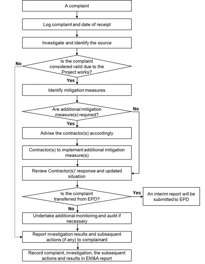
10.4
Log-Book
The ETL will keep a contemporaneous log-book of each and every instance or circumstance or change of circumstances which may affect the EIA and every non-compliance from the recommendations of the EIA Report or the EP. The ETL will notify the IEC within one working day of the occurrence of any such instance or circumstance or change of circumstance. The ETL’s log-book will be kept readily available for inspection by persons assisting in supervision of the implementation of the EIA Report recommendations (such as Project Proponent, IEC and Contractor(s)) or by EPD or his authorised officers.
11.
Reporting
11.1
General
Reports can be provided in an electronic medium upon agreeing the format with Project Proponent and EPD. The monitoring data (baseline and impact) will also be made available through a dedicated internet website that would be agreed with relevant authority.
Types of reports that the ET will prepare and submit include baseline monitoring report, monthly EM&A reports, quarterly EM&A summary reports, annual EM&A review reports and final EM&A report. In accordance with Annex 21 of the EIAO-TM, a copy of the baseline monitoring, monthly, quarterly summary, annual review and final EM&A reports will be made available to the Director of Environmental Protection.
11.2
Baseline
Monitoring Report
In respect of the water quality EM&A works for the dredging works of the Project, the ET will prepare and submit a Baseline Monitoring Report at least 2 weeks before commencement of construction of the Project for agreement on the Action/Limit Levels for water quality. Copies of the Baseline Monitoring Report will be submitted to EPD, the Project Proponent, the Contractor(s) and the IEC as appropriate.
The Baseline Monitoring Report, will include at least the following:
(1) Up to half a page executive summary.
(2) Brief project background information.
(3) Drawings showing locations of the baseline monitoring stations.
(4) Monitoring results (in both hard and electronic copies) together with the following information:
§ monitoring methodology;
§ name of laboratory and types of equipment used and calibration details;
§ parameters monitored;
§ monitoring locations (and depth); and
§ monitoring date, time, frequency and duration.
(5) Details on influencing factors, including:
§ major activities, if any, being carried out on the site during the period;
§ weather conditions during the period; and
§ other factors which might affect the results.
(6) Determination of the Action and Limit Levels for each monitoring parameter.
(7) Revisions for inclusion in the EM&A Manual.
(8) Comments, recommendations and conclusions.
11.3 Monthly EM&A Reports
The results and findings of the EM&A work required in this Manual will be recorded in the Monthly EM&A Reports prepared by the ET. The EM&A report will be prepared and submitted within 2 weeks of the end of each reporting month, with the first report due the month after construction commences. Each monthly EM&A report will be submitted to the Contractor(s), the IEC, the Project Proponent and the EPD, as well as to other relevant departments as required. Before submission of the first EM&A Report, the ET will liaise with the parties on the exact number of copies and format of the reports in both hard copy and electronic medium.
The ET will review the number, frequency and location of monitoring stations and parameters as mentioned in the EM&A Manual or on as needed basis, in order to cater for any changes in the surrounding environment and the nature of works in progress.
11.3.1 Contents of Monthly EM&A Report
(1) 1-2 pages executive summary, comprising:
§ breaches of Action and Limit levels;
§ complaint log;
§ notifications of any summons and successful prosecutions;
§ reporting changes; and
§ forecast of impact predictions.
(2) Basic project information including a synopsis of the project organisation, programme and management structure, and a drawing of the Project area showing the environmentally sensitive receivers and the locations of monitoring and control stations, programme, management structure and the work undertaken during the month.
(3) Environmental status, comprising:
§ works undertaken during the month (such as location of works, quantities of waste generated); and
§ drawing showing the project area, any environmental sensitive receivers and the locations of the monitoring and control stations.
(4) A brief summary of EM&A requirements including:
§ monitoring parameters;
§ environmental quality performance limits (i.e. Action and Limit Levels);
§ Event and Action Plans;
§ environmental mitigation measures, as recommended in the Project EIA Report; and
§ environmental requirements in contract documents.
(5) Advice on the implementation status of environmental protection, mitigation and pollution control measures as recommended in the Project EIA Report and summarised in the updated implementation schedule.
(6) Monitoring results (in both hard and electronic copies) together with the following information:
§ monitoring methodology;
§ name of laboratory and equipment used and calibration details;
§ parameters monitored;
§ monitoring locations (and depth); and
§ monitoring date, time, frequency, and duration;
(7) Graphical plots of trends of monitored parameters for representative monitoring stations annotated against the following:
§ major activities being carried out on site during the period;
§ weather conditions during the period; and
§ any other factors which might affect the monitoring results;
(8) A summary of non-compliance (exceedances) of the environmental quality performance limits (Action and Limit Levels).
(9) A review of the reasons for and the implications of non-compliance including a review of pollution sources and working procedures.
(10) A description of the actions taken in the event of non-compliance and deficiency reporting and any follow-up procedures related to earlier non-compliance.
(11) A summary record of complaints received (written or verbal) for each media, including locations and nature of complaints, liaison and consultation undertaken, actions and follow-up procedures taken and summary of complaints.
(12) A summary record of notifications of summons, successful prosecutions for breaches of environmental protection/pollution control legislation, and actions to rectify such breaches.
(13) A forecast of the works programme, impact predictions and monitoring schedule for the next one month.
(14) Comments, recommendations and conclusions for the monitoring period.
11.4
Quarterly
EM&A Summary Report
The ET will submit Quarterly EM&A Summary Reports for the EM&A works every 3 months. These reports should contain at least the following information:
(1) Executive Summary (1-2 pages).
(2) Basic project information including a synopsis of the Project organisation, programme, contacts of key management, compliance with the environmental permit condition (status of submission) and a synopsis of work undertaken during the quarter.
(3) A brief summary of EM&A requirements including:
§ environmental quality performance limits (Action and Limit Levels); and
§ environmental mitigation measures, as recommended in the Project EIA Report.
(4) Advice on the implementation status of environmental protection and pollution control/mitigation measures as recommended in the Project EIA Report and summarised in the updated implementation schedule.
(5) Drawings showing the Project area, any environmental sensitive receivers and the locations of the monitoring and control stations.
(6) Graphical plots of the trends of monitored parameters over the past four months (the last month of the previous quarter and the present quarter) for representative monitoring stations annotated against:
§ the major activities being carried out on site during the period;
§ weather conditions during the period; and
§ any other factors which might affect the monitoring results.
(7) A summary of non-compliance (exceedances) of the environmental quality performance limits (Action and Limit Levels).
(8) An Impact Prediction Review will be prepared to compare project predictions with actual impacts for the purpose of assessing the accuracy of predictions on the EIA study. The review will focus on the comparison between the EIA study predictions with the EM&A monitoring results. If any excessive variation was found, a summary of investigation and follow up procedure taken will be addressed accordingly.
(9) A brief review of the reasons for and the implications of non-compliance including review of pollution sources and working procedures.
(10) A summary description of the actions taken in the event of non-compliance and any follow-up procedures related to earlier non-compliance.
(11) A summarised record of complaints received (written or verbal) for each media, liaison and consultation undertaken, actions and follow-up procedures taken.
(12) Comments (e.g. effectiveness and efficiency of the mitigation measures), recommendations (e.g. any improvement in the EM&A programme) and conclusions for the quarter.
11.5 Annual EM&A Review Reports
Annual EM&A reports will be prepared by the ET once per year during the course of the Project. The annual EM&A reports will contain at least the following information:
(1) Executive Summary (1-2 pages).
(2) Drawings showing the project area, any environmental sensitive receivers and the locations of the monitoring and control stations.
(3) Basic project information including a synopsis of the project organization, contacts for key management staff and a synopsis of work undertaken during the course of the project.
(4) A brief summary of EM&A requirements including:
§ environmental mitigation measures as recommended in the project EIA Report;
§ environmental impact hypotheses tested;
§ environmental quality performance limits (Action and Limit Levels);
§ monitoring parameters; and
§ Event and Action Plans.
(5) A summary of the implementation status of environmental protection and pollution control/mitigation measures as recommended in the project EIA Report and summarised in the updated implementation schedule.
(6) Graphical plots and the statistical analysis of the trends of monitored parameters over the course of the project annotated against the following:
§ the major activities being carried out on site during the period;
§ weather conditions during the period; and
§ any other factors which might affect the monitoring results.
(7) A summary of non-compliance (exceedances) of the environmental quality performance limits (Action and Limit Levels).
(8) A review of the reasons for and the implications of non-compliance including review of pollution sources and working procedures as appropriate.
(9) A description of the actions taken in the event of non-compliance.
(10) A summary record of complaints received (written or verbal) for each media, liaison and consultation undertaken, actions and follow-up procedures taken.
(11) A summary record of notifications of summonses and successful prosecutions for breaches of the current environmental protection/pollution control legislations, locations and nature of the breaches investigation, follow-up actions taken and results.
(12) A comparison of the EM&A data with the EIA predictions with annotations and explanations for any discrepancies, including a review of the validity of EIA predictions and identification of shortcomings in the EIA recommendations.
(13) A review of the monitoring methodology adopted and with the benefit of hindsight, comment on its effectiveness, including cost effectiveness.
(14) A review of the success of the EM&A programme, including a review of the effectiveness and efficiency of the mitigation measures, and recommendations for any improvements in the EM&A programme.
(15) A clear cut statement on the environmental acceptability of the project with reference to specific impact hypotheses and a conclusion to state the return to ambient and/or the predicted scenario as the EIA findings.
11.6
Final
EM&A Report
The Final EM&A Report will be prepared by the ET after completion of the EM&A programme of the Project. The Final EM&A Report will contain at least the following information:
(1) Executive Summary (1-2 pages).
(2) Drawings showing the project area, any environmental sensitive receivers and the locations of the monitoring and control stations.
(3) Basic project information including a synopsis of the project organization, contacts for key management staff and a synopsis of work undertaken during the course of the project.
(4) A brief summary of EM&A requirements including:
§ environmental mitigation measures as recommended in the project EIA Report;
§ environmental impact hypotheses tested;
§ environmental quality performance limits (Action and Limit Levels);
§ monitoring parameters; and
§ Event and Action Plans.
(5) A summary of the implementation status of environmental protection and pollution control/mitigation measures as recommended in the project EIA Report and summarised in the updated implementation schedule.
(6) Graphical plots and the statistical analysis of the trends of monitored parameters over the course of the project annotated against the following:
§ the major activities being carried out on site during the period;
§ weather conditions during the period; and
§ any other factors which might affect the monitoring results.
(7) A summary of non-compliance (exceedances) of the environmental quality performance limits (Action and Limit Levels).
(8) A review of the reasons for and the implications of non-compliance including review of pollution sources and working procedures as appropriate.
(9) A description of the actions taken in the event of non-compliance.
(10) A summary record of all complaints received (written or verbal) for each media, liaison and consultation undertaken, actions and follow-up procedures taken.
(11) A summary record of notifications of summonses and successful prosecutions for breaches of the current environmental protection/pollution control legislations, locations and nature of the breaches investigation, follow-up actions taken and results.
(12) A comparison of the EM&A data with the EIA predictions with annotations and explanations for any discrepancies, including a review of the validity of EIA predictions and identification of shortcomings in the EIA recommendations.
(13) A review of the monitoring methodology adopted and with the benefit of hindsight, comment on its effectiveness, including cost effectiveness.
(14) A review of the success of the EM&A programme, including a review of the effectiveness and efficiency of the mitigation measures.
(15) A clear cut statement on the environmental acceptability of the project with reference to specific impact hypotheses and a conclusion to state the return to ambient and/or the predicted scenario as the EIA findings.
11.7 Data Keeping
The site documents such as the monitoring field records, laboratory analysis records, site inspection forms, etc. are not required to be included in the EM&A Reports for submission. However, the documents will be kept by the ETL and be ready for inspection upon request. Relevant information will be clearly and systematically recorded in the documents. The monitoring data will also be recorded electronically, and the soft copy will be available upon request. The documents and data will be kept for at least one year after the completion of the EM&A works for the construction and operation phases.
11.8 Interim Notifications of Environmental Quality Limit Exceedances
With reference to Event and Action Plans, when the environmental quality limits are exceeded, the ET will notify the Contractor(s), Project Proponent, IEC and EPD as appropriate within 24 hours of the identification of the exceedance. The notification will be followed up with each party on the results of the investigation, proposed action and success of the action taken, with any necessary follow-up proposals. A sample template for the interim notifications is shown in Annex B.
([1]) AJ Underwood (1997) Experiments in Ecology: their logical design and interpretation using analysis of variance.
([2]) Schmitt RJ, Osenberg CW (1996) Detecting Ecological Impacts: concepts and applications in coastal habitats. Academic Press.
([3]) Underwood AJ (1997) Experiments in Ecology: their logical design and interpretation using analysis of variance.
([4]) Concerns about positional errors must be weighed against the aims of the survey. Horizontal accuracies to ±20 metres are acceptable distance.
([5]) Value of commercial species will be estimated based on the best available data on published by Fish Marketing Organization (FMO). Available at https://www.fmo.org.hk/price?id=8&fid=9&path=12_43_56