Environmental Impact Assessment Ordinance (Cap. 499), Section 5 (7)
Environmental Impact Assessment Study Brief No. ESB-134/2005
Project Title : Emissions Control Project at the Castle Peak Power Station “B” Units
(hereinafter known as the "Project")
Name of Applicant : Castle Peak Power Company Limited,
CLP Power Generation Projects Department,
Black Point Power Station,
G/F East Wing, GBG Management Building
Lung Kwu Tan, Tuen Mun, N.T.
(hereinafter known as the "Applicant")
1. BACKGROUND
1.1 An application (No. ESB-134/2005) for an Environmental Impact Assessment (EIA) study brief under section 5(1) of the Environmental Impact Assessment Ordinance (EIAO) was submitted by the Applicant on 28 September 2005 with a project profile (No. PP-262/2005) (the Project Profile).
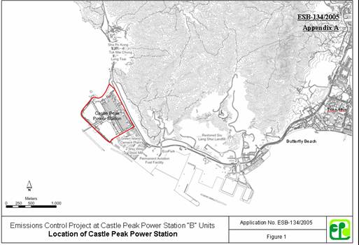
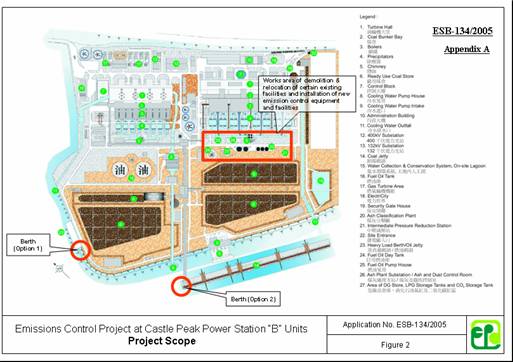
1.2 The scope of the Project is to construct and operate emissions control at Castle Peak Power Station “B” Units (CPB) , as shown in Figures 1 and 2 in Appendix A and described below :
(i) Demolition of existing facilities at CPB including the 4680 tonne Fuel Oil Day Tank, Fuel Oil Pump House, Ash Plant Substation, Ash and Dust Control Room, and Dangerous Goods (DG) Store;
(ii) Relocation or re-routing of existing facilities including Underground Pipeworks, 2626 litre Carbon Dioxide (CO2) Storage Tank, 2 numbers of 4600 litre Liquefied Petroleum Gas (LPG) Storage Tank, Intermediate Pressure Reduction Station, Oil Interceptors, Oils Sump, Oil Sewer Manholes and Foul Water Pumping Station;
(iii) Installation of new emission control equipment and facilities including the Selective Catalytic Reduction (SCR) for NOx emission control, Limestone Flue Gas Desulphurisation (LS-FGD) for SO2 emission control;
(iv) Provision of Reagent and By-Product Handling and Storage Facilities including limestone silos, limestone slurry tanks, gypsum dewatering and storage facilities for the LS-FGD operations and the urea storage silos, urea dissolving tanks, urea solution storage tanks and urea-to-ammonia reactors for the SCR operations;
(v) Provision of additional berthing facilities for loading and unloading of the additional reagents, including up to 40,000 tonnes per year of urea, 150,000 tonnes per year of limestone and by-products including 257,000 tonnes per year of gypsum.
1.3 The Project is a Material Change to the existing Castle Peak Power Station, which is an exempted designated project (DP), because of the changes introduced by the SCR and LS-FDG operations to the types and quantities of wastes, emissions and effluents. In addition, the Project has or is likely to have other DP elements under Schedule 2 of the EIAO, including :
(i) Item 16 in Part 2 – Decommissioning of a store for oil with a storage capacity exceeding 200 tonnes;
(ii) Item C12 in Part 1 - A dredging operation which is less than 100 m from a seawater intake point;
(iii) Item G6 in Part 1 - A waste disposal facility for gypsum;
(iv) Item K6 in Part 1 - A chemical plant with a storage capacity of more than 500 tonnes and in which substances are processed or produced.
1.4 Pursuant to section 5(7)(a) of the EIAO, the Director of Environmental Protection (the Director) issues this EIA study brief to the Applicant to carry out an EIA study.
1.5 The purpose of this EIA study is to provide information on the nature and extent of environmental impacts arising from the construction and operation of the Project and related activities that take place concurrently. This information will contribute to decisions by the Director on :
(i) the overall acceptability of any adverse environmental consequences that are likely to arise as a result of the Project;
(ii) the conditions and requirements for the detailed design, construction and operation of the Project to mitigate against adverse environmental consequences wherever practicable; and
(iii) the acceptability of residual impacts after the proposed mitigation measures are implemented.
2. OBJECTIVES OF THE EIA STUDY
2.1 The objectives of the EIA study are as follows :
(i) to describe the Project and associated works together with the requirements for carrying out the Project;
(ii) to identify and describe elements of community and environment likely to be affected by the Project and/or likely to cause adverse impacts to the Project, including natural and man-made environment and the associated environmental constraints;
(iii) to provide information on the consideration of alternatives to avoid and minimize potential environmental impacts to ecologically sensitive areas and other sensitive uses; to compare the environmental benefits and dis-benefits of each of different options; to provide reasons for selecting the preferred option(s) and to describe the part environmental factors played in the selection of preferred option(s);
(iv) to identify and quantify emission sources and determine the significance of impacts on sensitive receivers and potential affected uses;
(v) to identify and quantify any potential landscape and visual impacts and to propose measures to mitigate these impacts;
(vi) to identify and quantify any potential losses or damage to flora, fauna and natural habitats and to propose measures to mitigate these impacts;
(vii) to propose the provision of mitigation measures so as to minimize pollution, environmental disturbance and nuisance during construction and operation of the Project;
(viii) to investigate the feasibility, practicability, effectiveness and implications of the proposed mitigation measures;
(ix) to identify, predict and evaluate the residual environmental impacts (i.e. after practicable mitigation) and the cumulative effects expected to arise during the construction and operation phases of the Project in relation to the sensitive receivers and potential affected uses;
(x) to identify, assess and specify methods, measures and standards, to be included in the detailed design, construction and operation of the Project which are necessary to mitigate these environmental impacts and cumulative effects and reduce them to acceptable levels;
(xi) to investigate the extent of the secondary environmental impacts that may arise from the proposed mitigation measures and to identify constraints associated with the mitigation measures recommended in the EIA study, as well as the provision of any necessary modification; and
(xii) to design and specify environmental monitoring and audit requirements to ensure the effective implementation of the recommended environmental protection and pollution control measures.
3. DETAILED REQUIREMENTS OF THE EIA STUDY
3.1 The Purpose
The purpose of this study brief is to scope the key issues of the EIA study. The Applicant has to demonstrate in the EIA report that the criteria in the relevant sections of the Technical Memorandum on the Environmental Impact Assessment Process of the Environmental Impact Assessment Ordinance (hereinafter referred to as “the TM”) are complied with.
3.2 The Scope
3.2.1 The scope of this EIA study shall cover the Project mentioned in sub-section 1.2 above. The EIA study shall address the likely key issues described below, together with any other key issues identified during the course of the EIA study:
(i) potential air quality and noise impacts from construction and operation of the Project to nearby sensitive receivers, taking into account the cumulative impact from the existing and planned sources of pollution in the vicinity of the Project;
(ii) potential water quality impact from the construction and operation of the Project on the relevant water system(s);
(iii) potential losses or damage to flora, fauna and natural habitats and the potential ecological impacts from the Project;
(iv) waste arising as a result of the construction and operation activities of the Project, including the management of dredged marine sediment; and
(v) potential land contamination from demolition, relocation or re-routing of existing facilities.
3.3 Consideration of Alternatives
3.3.1 The Need of the Project
The Applicant shall study and review the need of the Project, and provide information to justify the need. The Applicant shall explain clearly the purpose and objectives of the Project and describe the scenarios with and without the Project.
3.3.2 Consideration of Different Technology and Emission Controls Options
In addition to the proposed SCR and LS-FDG processes mentioned in sub-section 1.2 above, the Applicant shall consider other feasible emission controls options for the Project, provide justification regarding how the proposed scheme is arrived at, including the descriptions of the environmental factors considered in the option selection. Alternative emission controls options and selection of the most suitable technology shall be reviewed and investigated. A comparison of the environmental benefits and dis-benefits of possible emission controls options and alternative technologies and design shall be made with a view to recommending the preferred option to maximise environmental benefits and avoid/minimize adverse environmental effects to the maximum practicable extent.
3.3.3 Consideration of Alternative Construction Methods and Sequences of Works
Taking into consideration the combined effect with respect to the severity and duration of the construction impacts to the affected sensitive receivers, the EIA study shall explore alternative construction methods and sequences of works for the Project, with a view to avoid prolonged adverse environmental impacts to the maximum practicable extent. A comparison of the environmental benefits and dis-benefits of applying different construction methods and sequence of works shall be made.
3.3.4 Selection of Preferred Scenario
Taking into consideration of the findings in sub-sections 3.3.2 and 3.3.3 above, the Applicant shall recommend/justify the adoption of the preferred scenario that will maximise environmental benefits and avoid or minimize adverse environmental effects arising from the Project, and adequately describe the part that environmental factors played in arriving at the final selection.
3.4 Technical Requirements
The Applicant shall conduct the EIA study to address environmental aspects as described in sub-sections 3.1, 3.2 and 3.3 above. The EIA study shall include the following technical requirements on specific impacts.
3.4.1 Air Quality Impact
3.4.1.1 The Applicant shall follow the criteria and guidelines as stated in Section 1 of Annex 4 and Annex 12 of the TM for evaluating and assessing the air quality impact due to the construction and operation of the Project, as stipulated in Sections 1.2 and 1.3 above.
3.4.1.2 As stipulated in Section 1.2 above, the Project is for reducing the overall NOx and SO2 emission from the Castle Peak Power Station “B” Units. The Applicant may carry out a comparative study to demonstrate if the stack emission impacts of the “B” Units before and after the Project will lead to lower air quality impacts at the Air Sensitive Receivers (ASRs) including the areas of Tuen Mun, Lung Kwu Tan, Ha Pak Nai, Sheung Pak Nai, Tin Shui Wai, So Kwun Wat, Tai Lam Chung and Tung Chung by using either a simple screening tool such as ISCST3 Gaussian model or a more sophisticated tool, such as wind tunnel test, if necessary. If result of the comparative study shows that the air quality impacts at ASRs are worsened, the air quality impact assessment following the technical requirements as described in Section 3.4.1.5 below shall be carried out to evaluate the cumulative impacts at the identified ASRs against the criteria set out in section 1 of Annex 4 of the TM. The cumulative assessment for the stack emission impact shall take into account the project specific impacts together with a regional-wide emission impact for background concentration.
3.4.1.3 The Study Area for air quality impact assessment shall generally be defined by a distance of 500 metres from the boundary of the Project site, and it shall be extended to include other areas that may have a bearing on the environmental acceptability of the Project. For this Project, the assessment shall include the existing and planned/committed air sensitive receivers within the study area, areas of Tuen Mun, Lung Kwu Tan, Ha Pak Nai, Sheung Pak Nai, Tin Shui Wai, So Kwun Wat, Tai Lam Chung and Tung Chung, where the air quality may be potentially affected by the Project. Such assessment shall be based on the best available information at the time of the assessment.
3.4.1.4 The Applicant shall assess the air pollutant concentrations with reference to the Guidelines for Local-Scale Air Quality Assessment Using Models given in Appendices B1 – B3 or other methodology as agreed by the Director.
3.4.1.5 The air quality impact assessment shall include the following:
(i) Background and Analysis of Activities
(a) Provide background information relating to air quality issues relevant to the Project, e.g. description of the types of activities of the Project that may affect air quality during operation stage.
(b) Present background air quality levels in the assessment area for the purpose of evaluating cumulative operational air quality impacts.
(c) Consider alternative modes of operation to minimize the operational air quality impact.
(ii) Identification of Air Sensitive Receivers (ASRs) and Examination of Emission/ Dispersion Characteristics
(a) Identify and describe representative existing and planned/committed ASRs, such as the proposed Tung Wah Group of Hospital Youth Holiday Camp at Siu Lang Shui, that would be affected by the Project, including those earmarked on the relevant Outline Zoning Plans, Development Permission Area Plans, Outline Development Plans and Layout Plans. The Applicant shall select the assessment points of the identified ASRs such that they represent the worst impact point of these ASRs. A map showing the location and description including name of buildings, their uses and height of the selected assessment points shall be given. The separation distances of these ASRs from the nearest emission sources shall also be given.
(b) Provide an exhaustive list of air pollutant emission sources within the Castle Peak Power Station which are to have impact related to the Project based on the analysis of the operational activities in Section 3.4.1.5(i) above. Apart from stack emissions, it is also necessary to address any air quality issue due to additional marine traffic emissions for transportation of materials including limestone and gypsum. Besides, if the likely concurrent projects are identified relevant, its possible emissions shall also be taken into account in the air quality impact assessment. Confirmation of the validity of the assumptions and the magnitude of the activities shall be obtained from the relevant parties and documented.
(c) Describe any topographical and man-made features that may affect the dispersion characteristics of the area.
(iii) Operational Phase Air Quality Impact
(a) The Applicant shall assess the expected air pollutants, including gaseous emissions and dust, at the identified ASRs based on an assumed reasonably worst-case scenario. The evaluation shall be based on the strength of the emission sources identified in Section 3.4.1.5(ii)(b) above. The Applicant shall follow the methodology as described in Section 3.4.1.5 (iv) below when carrying out the quantitative assessment.
(iv) Quantitative Assessment Methodology
(a) In choosing the types of models (such as physical or numerical) to be used for quantitative assessment of the operational phase air quality impact, the Applicant shall apply the general principles enunciated in the modelling guidelines in Appendices B-1 to B-3 while making allowance for the specific characteristics of the Project. The specific methodology must be documented in such level of details (preferably with tables and diagrams) to allow the readers of the assessment report to grasp how the model is set up to simulate the situation at hand without referring to the model input files. Details of the calculation of the emission rates of air pollutants for input into the modelling shall be presented in the EIA report. The Applicant must ensure consistency between the text description and the model files. In case of doubt, prior agreement between the Applicant and the Director on the specific modelling details should be sought.
(b) The Applicant shall identify the key/representative air pollutant parameters (types of pollutants and the averaging time concentration) to be evaluated and provide explanation for choosing these parameters for the assessment of the impact of the Project.
(c) If the predicted air quality impacts at the ASRs are worsened by the Project, the Applicant shall calculate the cumulative air pollutant concentrations at the identified ASRs identified under Section 3.4.1.5(ii) above and compare these results against the criteria set out in Section 1 of Annex 4 in the TM. The predicted air quality impacts (both unmitigated and mitigated) shall be presented in the form of summary table and pollution contours as appropriate, to be evaluated against the relevant air quality standards and on any effect they may have on the land use implications. If applicable, plans of a suitable scale should be used to present pollution contour to allow buffer distance requirements to be determined properly.
(v) Mitigation Measures for Non-compliance
The Applicant shall propose remedies and mitigating measures where the predicted air quality impact exceeds the criteria set in Section 1 of Annex 4 in the TM. If these measures will result in any constraints on future land use planning outside the Project site, the Applicant shall liaise with the relevant government departments/authorities and document the agreement in the EIA Report in order to demonstrate that the proposed measures are feasible and practicable. The Applicant shall demonstrate quantitatively that the residual impacts after incorporation of the proposed mitigating measures will comply with the criteria stipulated in Section 1 of Annex 4 in the TM.
(vi) Submission of Model Files
Input and output file(s) of the model run(s) shall be submitted to the Director in electronic format.
(vii) Constructional Phase Air Quality Impact
The Applicant shall follow the requirements of the Air Pollution Control (Construction Dust) Regulation to ensure constructional dust impacts are controlled within the relevant standards as stipulated in section 1 of Annex 4 of the TM. An audit and monitoring program during constructional stage shall be devised to verify the effectiveness of the control measures and to ensure that the construction dust levels be brought under proper control. The Applicant shall follow the methodology set out in subsection 3.4.1.7 (iv) above when carrying out the quantitative assessment.
3.4.2 Noise Impact
3.4.2.1 The Applicant shall follow the criteria and guidelines for evaluating and assessing noise impact as stated in Annexes 5 and 13 of the TM, respectively.
3.4.2.2 The noise impact assessment shall include the following :
(i) Determination of Study Area
The study area for the noise impact assessment shall generally include areas within 300m from the Project boundary. Subject to the agreement of the Director, the study area could be reduced accordingly if the first layer of noise sensitive receivers (NSRs), closer than 300m from the outer Project limit, provides acoustic shielding to those receivers at distances further away from the Project. Subject to the agreement of the Director, the study area shall be expanded to include NSRs at distances over 300m from the Project which would be affected by the construction and operation of the Project.
(ii) Provision of Background Information and Existing Noise Levels
The Applicant shall provide background information relevant to the Project, e.g. relevant previous or current studies. Unless required for determining the planning standards, e.g. those for planning of fixed noise sources (such as ventilation systems of traffic noise enclosures), no existing noise levels are particularly required.
(iii) Identification of Noise Sensitive Receivers
(a) The Applicant shall refer to Annex 13 of the TM when identifying the NSRs. The NSRs shall include existing NSRs and planned/committed noise sensitive developments and uses, such as the proposed Tung Wah Group of Hospital Youth Holiday Camp at Siu Lang Shui, earmarked on the relevant Outline Zoning Plans, Development Permission Area Plans, Outline Development Plans, Layout Plans and other relevant published land use plans. Photographs of existing NSRs shall be appended to the EIA report.
(b) The Applicant shall select assessment points to represent identified NSRs for carrying out quantitative noise assessment described below. The assessment points shall be agreed with the Director prior to the quantitative noise assessment. A map showing the location and description such as name of building, use, and floor of each and every selected assessment point shall be given. For planned noise sensitive land uses without committed site layouts, the Applicant should use the relevant planning parameters to work out representative site layouts for operational noise assessment purpose.
(iv) Provision of an Emission Inventory of the Noise Sources
The Applicant shall provide an inventory of noise sources including representative construction equipment for construction noise assessment, and traffic flow/ fixed plant equipment (e.g. ventilation systems of traffic noise enclosures), as appropriate, for operational noise assessment. Confirmation of the validity of the inventory shall be obtained from the relevant government departments/authorities and documented in the EIA report.
(v) Construction Noise Assessment
(a) The assessment shall cover the cumulative noise impacts due to the construction works of the Project and other concurrent projects identified during the course of the EIA study.
(b) The Applicant shall carry out assessment of noise impact from construction (excluding percussive piling) of the Project during daytime, i.e. 7 a.m. to 7 p.m., on weekdays other than general holidays in accordance with the methodology in paragraphs 5.3. and 5.4 of Annex 13 of the TM. The criteria in Table 1B of Annex 5 of the TM shall be adopted in the assessment.
(c) To minimize the construction noise impact, alternative construction methods to replace percussive piling shall be proposed as far as practicable.
(d) If the unmitigated construction noise levels are found exceeding the relevant criteria, the Applicant shall propose practicable direct mitigation measures (including movable barriers, enclosures, quieter alternative methods, re-scheduling and restricting hours of operation of noisy tasks) to minimize the impact. If the mitigated noise levels still exceed the relevant criteria, the duration of the noise exceedance shall be given.
(e) The Applicant shall, as far as practicable, formulate a reasonable construction programme so that no work will be required in restricted hours as defined under the Noise Control Ordinance (NCO). In case the Applicant needs to evaluate whether construction works in restricted hours as defined under the NCO are feasible or not in the context of programming construction works, reference should be made to relevant technical memoranda issued under the NCO. Regardless of the results of construction noise impact assessment for restricted hours, the Noise Control Authority will process Construction Noise Permit (CNP) application, if necessary, based on the NCO, the relevant technical memoranda issued under the NCO, and the contemporary conditions/situations. This aspect should be explicitly stated in the noise chapter and the conclusions and recommendations chapter in EIA report.
(vi) Operational Noise Assessment
(a) Fixed Noise Sources
If the Project will cause impacts from any fixed noise sources, such as the ventilation systems of plants, the following assessment shall be followed.
(a1) Assessment of Fixed Source Noise Levels
The Applicant shall calculate the expected noise using standard acoustics principles. Calculations for the expected noise shall be based on assumed plant inventories and utilization schedule for the worst-case scenario. The Applicant shall calculate noise levels taking into account correction of tonality, impulsiveness and intermittency in accordance with Technical Memorandum for the Assessment of Noise from Places other than Domestic Premises, Public Places or Construction Sites issued under the NCO.
(a2) Presentation of Noise Levels
The Applicant shall present the existing and future noise levels in Leq (30 min) at the NSRs at various representative floor levels (in m P.D.) on tables and plans of suitable scale. A quantitative assessment at the NSRs for the proposed fixed noise source(s) shall be carried out and compared against the criteria set out in Table 1A of Annex 5 of the TM.
(a3) Proposals for Noise Mitigation Measures
The Applicant shall propose direct technical remedies within the Project limits in situations where the predicted noise level exceeds the criteria set out in Table 1A of Annex 5 of the TM to protect the affected NSRs.
(vii) Assessment of Side Effects and Constraints
The Applicant shall identify, assess and propose means to minimize any side effects and to resolve any potential constraints due to the inclusion of any recommended direct technical remedies.
(viii) Evaluation of Constraints on Planned Noise Sensitive Developments/Land uses
For planned noise sensitive uses which will still be affected even with practicable direct technical remedies in place, the Applicant shall propose, evaluate and confirm the practicability of additional measures within the planned noise sensitive uses and shall make recommendations on how these noise sensitive uses will be designed for the information of relevant parties. The Applicant shall take into account agreed environmental requirements / constraints identified by the EIA study to assess the development potential of concerned sites which shall be made known to the relevant parties.
3.4.3 Water Quality Impact
3.4.3.1The Applicant shall follow the criteria and guidelines for evaluating and assessing water pollution as stated in Annexes 6 and 14 of the TM respectively.
3.4.3.2 The Study Area for the purpose of water quality impact assessment shall cover the North Western, North Western Supplementary, Western Buffer, Deep Bay Water Control Zones as designated under the Water Pollution Control Ordinance (WPCO), Cap. 358. Sensitive receivers including nearby beaches between Lung Kwu Sheung Tan and East of Ma Wan such as Lung Kwu Upper & Lower Beaches, Butterfly Beach, Castle Peak Beach, Kadoorie Beach, Cafeteria New & Old Beaches, Golden Beach, Dragon Beach, Angler’s Beach, Gemini Beach, Ho Mei Wan Beach, Casam Beach, Lido Beach and Ting Kau Beach, as well as the Ma Wan Fish Culture Zone, Lung Kwu Chau & Sha Chau Marine Park; and the ecological sensitive receivers identified in Ecological Impact Assessment in 3.4.6 shall be addressed in the water quality assessment. In addition, the sea water intakes for Shiu Wing Steel Mill and the proposed EcoPark in Tuen Mun Area 38, Castle Peak Power Station and Black Point Power Station, Tuen Mun Area 38 Industries Intakes, Tuen Mun Flushing Water Intake, etc. shall also be addressed. This Study Area may be extended to cover other areas such as stream courses and the associated water system, existing and new drainage system, wetland, estuaries, coastal, marine and fresh water, groundwater system; and the associated catchment area(s) being impacted and to be identified during the course of the EIA study.
3.4.3.3 The Applicant shall identify and analyse physical, chemical and biological disruptions of marine, estuarine, fresh water, ground water system(s) and the associated catchment area(s), stormwater drainage system and coastal water arising during the construction and operation of the Project.
3.4.3.4 The water quality impact assessment shall cover the following, but not limited to, major areas of concern:
i) Construction and operational impacts arising from the additional berthing facilities;
ii) Dredging of marine sediment for the construction and maintenance of berthing facilities;
iii) Impacts of demolition and relocation of existing facilities; and making reference to the findings of the Land Contamination Assessment in 3.4.5; and
iv) Impacts of wastewater and effluent treatment and disposal during operational stage of the Project, such as the selective catalytic reduction and flue gas desulphurization processes.
3.4.3.5 Essentially the assessment shall address the following:
i) Collection and review of background information on the existing and planned water system(s) and the respective catchment(s) and sensitive receivers which might be affected by the Project.
ii) Characterization of water and sediment quality of the water system(s) and respective catchment and sensitive receivers which might be affected by the Project based on existing information or site surveys and tests as appropriate.
iii) Identification and analysis of existing and planned future activities and beneficial uses related to the water system(s) and identification of water sensitive receivers. The Applicant shall refer to, inter alia, those developments and uses earmarked on the relevant Outline Zoning Plans, Development Permission Area Plans, Outline Development Plans and Layout Plans;
iv) Establishment of pertinent water and sediment quality objectives, criteria and standards for the water system(s) and sensitive receivers in 3.4.3.5 (i), (ii) and (iii) above;
v) Identification of any alteration of water courses, natural streams, shoreline or bathometry, flow regimes, ground water levels, catchment types or areas;
vi) Review the specific construction methods and configurations of the Project, such as, but are not limited to, the dredging requirements; design and configuration of the berthing facilities;
vii) Review of the Project to identify any alteration of existing water course, natural streams/ ponds, shoreline or bathymetry, flow regimes, ground water level and catchment type or area;
viii) Identification, analysis and quantification of existing and likely future water and sediment pollution sources and loading, including point discharges and non-point sources to surface water runoff, spent industrial wastewater from the Project. Field investigation and laboratory tests shall be conducted as appropriate. Establishment and provision of an emission inventory on the quantities and characteristics of these pollution sources.
Wastewater and Non-point Sources Pollution
ix) Assessment and quantification on the adequacy of existing and future sewerage infrastructure to treat and dispose of the wastewater identified above. In general waste water generated shall have to meet the effluent discharge standards set out in the Technical Memorandum stipulated under the WPCO prior to discharge.
x) Assessment and quantification of existing and future water pollutants from non-point sources and analysis on the provision and adequacy of existing and future facilities to reduce such pollution.
Dredging, Filling and Dumping
xi) Identification and quantification of dredging, fill extraction, backfilling, mud/sediment transportation and disposal activities and requirements. Potential fill source and dumping ground to be involved shall also be identified. Field investigation, sampling and laboratory tests to characterize the sediment/mud concerned shall be conducted as appropriate. The potential for the release of contaminants during dredging shall be addressed using the chemical testing results derived from sediment and marine water samples collected on site and relevant historic data. Appropriate laboratory tests such as elutriate tests in accordance with the United States Army Corps of Engineers (USACE) method and sediment pore water (interstitial water) analyses shall be performed on the sediment samples to simulate and quantify the degree of mobilization of various contaminants such as metals, ammonia, nutrients, oxygen demand, trace organic contaminants (including Polychlorinated Biphenyls (PCBs), Polycyclic Aromatic Hydrocarbons (PAHs), Tributyltin (TBT) and chlorinated pesticides) into the water column during dredging. The ranges of parameters to be analyzed; the number, location, depth of sediment, type and methods of sampling; sample preservation; and chemical laboratory test methods to be used shall be subject to the approval of the Director. The Applicant shall also address the pattern of the sediment deposition and the potential increase in turbidity and suspended solid levels in the water column and at the sensitive receivers due to the disturbance of sediments during dredging, backfilling and dumping.
xii) In case of small scale dredging works and with the prior approval by the Director, the Applicant shall assess the potential increase in turbidity and suspended solids levels in the water column due to disturbance of marine sediments during dredging. The potential for release of contaminants during dredging shall also be addressed using the chemical testing results derived from sediment samples collected and tested in xi) above and relevant historic data;
Impact Prediction
xiii) Prediction and quantification, by mathematical modelling or other technique approved by the Director, of the impacts on the water system(s) and the sensitive receivers due to the construction and operation of the Project. The mathematical modeling requirements are set out in Appendix C of this Study Brief. Possible impacts include change in hydrology, flow regime, sediment erosion or deposition, water and sediment quality and the effects on the aquatic organism due to such changes in the affected water bodies. The prediction shall take into account and include possible different construction stages or sequences, and different operation stages.
xiv) Assessment of the cumulative impacts due to other related concurrent and planned projects, activities or pollution sources within a boundary around the Study Area to be agreed by the Director, that may have a bearing on the environmental acceptability of the Project through mathematical modelling. This shall include the potential cumulative construction and operational water quality impacts arising from, inter alia, the associated works of the Project, the activities and planned projects to be approved by the Director when the programme of the Project and associated works is confirmed during the course of the EIA study.
Mitigation
xv) Recommendation of appropriate mitigation measures to avoid or minimize the impacts identified above, in particular suitable mud dredging and disposal, and backfilling method(s). The residual impacts on the water system(s) and the sensitive receivers with regard to the relevant water and sediment quality objective, criteria, standards or guidelines shall be assessed and quantified by mathematical modeling as set out in Appendix C in this Study Brief or other techniques to be approved by the Director.
xvi) Identification and evaluation of the best practicable dredging, backfilling, marine mud disposal and reclamation methods to minimize marine mud disturbance and dumping requirements and demand for fill sources based on the criterion that existing marine mud shall be left in place and not be disturbed as far as possible.
xvii) Proposal of effective infrastructure upgrading or provision, water pollution prevention and mitigation measures to be implemented during the construction and operational stages so as to avoid and reduce the water and sediment quality impacts to within acceptable levels of standards. Requirements to be incorporated in the Project contract document shall also be proposed.
xviii) Best management practices to reduce storm water and non-point source pollution shall be investigated and proposed as appropriate. Attention shall be given to the water quality control and mitigation measures recommended in the “Practice Note for Authorized Persons and Registered Structural Engineers on Construction Site Drainage”.
3.4.3.1 Evaluation and quantification of residual impacts on the water system(s) and the sensitive receivers with regard to the appropriate water and sediment quality objectives, criteria, standards or guidelines using appropriate mathematical models as set out in Appendix C in this Study Brief or other techniques to be approved by the Director.
3.4.4 Waste Management Implications
3.4.4.1 The Applicant shall follow the criteria and guidelines for evaluating and assessing waste management implications as stated in Annexes 7 and 15 of the TM respectively.
3.4.4.2 The assessment of waste management implications shall cover the following:
(i) Analysis of Activities and Waste Generation
The Applicant shall identify the quantity, quality and timing of the waste arising as a result of the construction and operation activities of the Project, based on the sequence and duration of these activities.
(ii) Proposal for Waste Management
(a) Prior to considering the disposal options for various types of wastes, opportunities for reducing waste generation, on-site or off-site re-use and recycling shall be evaluated. Measures which can be taken in the planning and design stages e.g. by modifying the design approach and in the construction stage for maximizing waste reduction shall be separately considered.
(b) After considering the opportunities for reducing waste generation and maximizing re-use, the types and quantities of the wastes required to be disposed of as a consequence shall be estimated and the disposal options for each type of waste shall be described in detail. The management of the by-products to be generated from the FGD Process shall be addressed in details. The disposal method recommended for each type of waste shall take into account of the result of the assessment in (c) below.
(c) The impact caused by handling (including labelling, packaging & storage), collection, and disposal of wastes shall be addressed in detail and appropriate mitigation measures shall be proposed. This assessment shall cover the following areas :
- potential hazard;
- air and odour emissions;
- noise;
- wastewater discharge; and
- public transport.
(iii) Management of Dredged Marine Sediment
(a) The Applicant shall identify and quantify dredging, fill extraction, filling, mud/sediment transportation and disposal activities and requirements. Potential fill source and dumping ground to be involved shall also be identified. Field investigation, sampling and chemical and biological laboratory tests to characterize the sediment/mud concerned shall be conducted as appropriate. The ranges of parameters to be analyzed; the number, type and methods of sampling; sample preservation; chemical and biological laboratory test methods to be used shall be subject to the approval of the Director. The categories of sediments which are to be disposed of in accordance with a permit granted under the Disposal At Sea Ordinance (DASO) shall be identified by both chemical and biological tests, and their quantities estimated. If the presence of any seriously contaminated sediment which requires special treatment/disposal is confirmed, the Applicant shall identify the most appropriate treatment and/or disposal arrangement and demonstrate its feasibility.
3.4.5 Land Contamination
3.4.5.1 The Applicant shall follow the guidelines as stated in Sections 3.1 and 3.2 of Annex 19 in the TM for evaluation and assessing potential land contamination issues due to the demolition of the existing facilities (including the CPB Fuel Oil Tank, Fuel Oil Pump House, Dangerous Goods Store and Oil Interceptors, etc.) and relocation or re-routing of existing facilities (including Underground Pipeworks, 2626 litre Carbon Dioxide (CO2) Storage Tank, 2 numbers of 4600 litre Liquefied Petroleum Gas (LPG) Storage Tank, Intermediate Pressure Reduction Station, Oil Interceptors, Oils Sump, Oil Sewer Manholes and Foul Water Pumping Station, etc.) of the Project, as stipulated in Section 1.2(i) & (ii) above.
3.4.5.2 The Applicant shall provide a clear and detailed account of the present land use (including description of the activities, chemicals and hazardous substances handled with clear indication of their storage and location by reference to a site layout plan), the relevant past land use history in relation to possible land contamination (e.g. accident records, etc.) and the presence of any contaminated materials.
3.4.5.3 The Applicant shall submit a Contamination Assessment Plan (CAP) to the Director for agreement prior to conducting a contamination assessment of the site. The CAP shall include proposals on sampling and analysis required and shall aim at determining the nature and extent of the contamination of the site.
3.4.5.4 Based on the agreed CAP, the Applicant shall conduct a land contamination assessment and compile a Contamination Assessment Report (CAR) to document the findings and to confirm whether the site is contaminated or not. If land contamination is confirmed, a Remediation Action Plan (RAP) shall be prepared to formulate in detail any necessary remedial measures for management of the contaminated soil and materials.
3.4.5.5 The field investigation and sampling work should be conducted in a safe and proper manner and the RAP shall provide necessary measures for ensuring that the contaminated soil and materials will be handled and managed in a safe and proper manner.
3.4.5.6 The Applicant shall prepare the CAP, CAR and, if necessary, the RAP in accordance with ProPECC Practice Note No. 3/94 “Contaminated Land Assessment and Remediation” and other relevant guidance notes.
3.4.1.7 The Applicant shall address any hazards and environmental impacts associated with the potential land contamination, if confirmed, and the secondary hazards and environmental impacts that may arise from remediation and disposal of contaminated soil and materials. The assumptions, methodology, data, findings, recommendations and conclusions of CAP, CAR and, if necessary, the RAP shall be included in the EIA report.
3.4.6 Ecological Impact
3.4.6.1 The Applicant shall follow the criteria and guidelines for evaluating and assessing ecological impact as stated in Annexes 8 and 16 of the TM, respectively.
3.4.6.2 The study area for the purpose of this ecological impact assessment shall be the same as the study area for Water Quality Impact Assessment, or the area likely to be impacted by the Project.
3.4.6.3 In the ecological impact assessment, the Applicant shall examine the flora, fauna and other components of ecological habitats within the study area. The aim shall be to protect, maintain or rehabilitate the natural environment. In particular, the Project shall avoid impacts on recognized sites of conservation importance (e.g., Country or Marine Parks, Sites of Special Scientific Interest) and other ecological sensitive areas. The assessment shall identify and quantify as far as possible the potential ecological impacts associated with the Project.
3.4.6.4 The assessment shall include the following major tasks:
(i) review the findings of relevant studies and collate the available information regarding the ecological characteristics of the study area;
(ii) evaluate information collected and identify any information gap relating to the assessment of potential ecological impacts to coastal and aquatic environment;
(iii) if any information gap is identified in (ii) above, then carry out necessary field surveys and investigations to verify the information collected, fill the information gaps identified and fulfil the objectives of the EIA study;
(v) where field survey is found necessary and has been conducted in accordance with (iii) above, review the adequacy of the field survey and recommend, with full justifications, whether further field survey is required, having regard to the information available from previous studies and the results of the field survey conducted for this Project;
(vi) establish the general ecological profile and describe the characteristics of each habitat found; major information to be provided shall include :
(a) description of the physical environment;
(b) habitat maps of suitable scale showing the types and locations of habitats in the study area;
(c) ecological characteristics of each habitat type such as size, vegetation and/or substrate type, species present, dominant species found, species diversity and abundance, community structure, seasonal patterns, inter-dependence of the habitats and species, and presence of any features of ecological importance;
(d) representative colour photos of each habitat type and any important ecological features identified;
(e) species found that are rare, endangered and/or listed under local legislation, international conventions for conservation of wildlife/habitats or red data books;
(vi) investigate and describe the existing wildlife uses of various habitats with special attention to:-
(a) the Chinese White Dolphin, Sousa chinensis; and
(b) any other habitats and wildlife groups identified as having special conservation interest by the study.
(vii) describe recognized sites of conservation importance in the study area, in particular, the Sha Chau and Lung Kwu Chau Marine Park, and assess whether these sites will be affected by the Project or not;
(viii) using suitable methodology, identify and quantify as far as possible any direct, indirect, on-site, primary, secondary and cumulative ecological impacts such as destruction of habitats, reduction of species abundance/diversity, loss of feeding and breeding grounds, reduction of ecological carrying capacity and habitat fragmentation and impacts of potentially harmful effects associated with any dredging work on ecological sensitive receivers;
(ix) identification of ecological sensitive receivers including sensitive elements of marine, subtidal, and intertidal communities/habitats which would be potentially affected directly or indirectly by the Project. The Sha Chau and Lung Kwu Chau Marine Park and the Chinese White Dolphin (Sousa chinensis) shall be included as major sensitive receivers;
(x) evaluate the significance and acceptability of the ecological impacts identified using well-defined criteria;
Assessment of Impacts on Chinese White Dolphins
(xi) review and incorporate the findings of relevant studies including the previous dolphins studies, in particular the "Population Biology of the Indo-Pacific Hump-backed Dolphin in Hong Kong Waters" (Wildlife Monograph No. 144, page 1-65, published in October 2000), and collate the available information regarding the ecological characteristics of the study area;
(xii) evaluate the information collected and identify any information gap relating to the assessment of potential impacts on the Chinese White Dolphins;
(xiii) carry out necessary field surveys and investigations to verify the information collected, fill the information gaps identified, if any, and to fulfil the objectives of the EIA study;
(xiv) present relevant survey findings including previous surveys conducted in relevant studies together with surveys carried out under this study;
(xv) assess the water quality and consequent ecological impacts on the Chinese White Dolphins, during the construction (such as dredging work) and operational stage of the Project. The assessment shall include :
(a) the prediction of water quality changes. Parameters to be assessed shall include dissolved oxygen, suspended solids, nutrients, ammonia, bacteria, deposition rate and potential contaminants present in disturbed or dredged sediment. The significance and acceptability of the predicted changes shall be evaluated using well-defined criteria;
(b) impacts on the Chinese White Dolphin of the possible use of piling and related activities during construction stage, due to shock wave and underwater noise generated; and
(c) potential risk and disturbance caused to the Chinese White Dolphin due to changes in marine traffic during construction and operational stages.
(xvi) assess the cumulative impacts of any nearby development on the dolphins;
(xvii) identify precautionary and mitigatory measures for protection of the Chinese White Dolphins. The proposed measures may include, but need not be limited to, those recommended in previous EIA studies and dolphins studies, such as ecological monitoring on the dolphins.
Ecological Mitigation
(xix) consider, evaluate and recommend possible alternatives and practicable mitigation measures to avoid, minimize, and/or compensate for the adverse ecological impacts identified.
(xx) evaluate the feasibility and effectiveness of the recommended mitigation measures and define the scope, type, location, implementation arrangement, subsequent management and maintenance of such measures;
(xxi) determine and quantify as far as possible the residual ecological impacts after implementation of the proposed mitigation measures;
(xxii) evaluate the severity and acceptability of the residual ecological impacts using well-defined criteria. If off-site mitigation measures are considered necessary to mitigate the residual impacts, the guidelines and requirements laid down in the PELB Technical Circular No. 1/97 shall be followed; and
(xxiii) review and recommend any ecological monitoring programme required.
3.4.7 Landscape and Visual Impact
3.4.7.1 Upon confirmation from the Applicant during the EIA Study that the proposed structures of the Project would not exceed the existing maximum building height of 83mPD and that no additional chimney will be erected in the Project, the Applicant shall provide a visual illustration of the Project. The visual illustration shall take the form of layout plans, elevations, and sections in appropriate scale and with dimensions, perspective drawings and photomontages to show the form, appearance and colour scheme of the Project from viewpoints to be agreed with the Director.
3.4.7.2 If the confirmation as mentioned in sub-section 3.4.7.1 cannot be provided by the Applicant during the EIA Study, the Applicant shall follow the criteria and guidelines as stated in Annexes 10 and 18 of the TM to evaluate and assess the landscape and visual impacts of any above ground structures and work areas associated with the Project. Detailed requirements of the landscape and visual impact assessment shall be agreed with the Director.
3.4.8 Summary of Environmental Outcomes
The EIA report shall contain a summary of key environmental outcomes arising from the EIA study, including the population and environmentally sensitive areas protected, environmentally friendly designs recommended, key environmental problems avoided, compensation areas included and the environmental benefits of environmental protection measures recommended.
3.4.9 Environmental Monitoring and Audit (EM&A) Requirements
3.4.9.1 The Applicant shall identify and justify in the EIA study whether there is any need for EM&A activities during the construction and operation phases of the Project and, if affirmative, to define the scope of EM&A requirements for the Project in the EIA study.
3.4.9.2 Subject to the confirmation of the EIA study findings, the Applicant shall comply with the requirements as stipulated in Annex 21 of the TM. The Applicant shall also propose real-time reporting of monitoring data for the Project through a dedicated internet website.
3.4.9.3 The Applicant shall prepare a Project Implementation Schedule (in the form of a checklist as shown in Appendix D to this EIA study brief) containing the EIA study recommendations and mitigation measures with reference to the implementation programme. The Project Implementation Schedule shall include the explicit agreement reached between the Applicant and relevant parties on the responsibility for funding, implementation, management and maintenance of mitigation measures. Alternatively, the Project Implementation Schedule shall include an undertaking from the Applicant to assume the responsibility of those mitigation measures until an agreement is reached between the Applicant and relevant parties on the funding, implementation, management and maintenance of mitigation measures.
4. DURATION OF VALIDITY
4.1 The Applicant shall notify the Director of the commencement of the EIA study. If the EIA study does not commence within 36 months after the date of issue of the EIA study brief, the Applicant shall apply to the Director for a fresh EIA study brief before commencement of the EIA study.
5. REPORT REQUIREMENTS
5.1 In preparing the EIA report, the Applicant shall refer to Annex 11 of the TM for the contents of an EIA report. The Applicant shall also refer to Annex 20 of the TM, which stipulates the guidelines for the review of an EIA report.
5.2 The Applicant shall supply the Director with the following number of copies of the EIA report and the executive summary:
(i) 50 copies of the EIA report in English and 80 copies of the executive summary (each bilingual in both English and Chinese) as required under section 6(2) of the EIAO to be supplied at the time of application for approval of the EIA report.
(ii) When necessary, addendum to the EIA report and the executive summary submitted in sub-section 5.2 (i) above as required under section 7(1) of the EIAO, to be supplied upon advice by the Director for public inspection.
(iii) 20 copies of the EIA report in English and 50 copies of the executive summary (each bilingual in both English and Chinese) with or without Addendum as required under section 7(5) of the EIAO, to be supplied upon advice by the Director for consultation with the Advisory Council on the Environment.
5.3 The Applicant shall, upon request, make additional copies of above documents available to the public, subject to payment by the interested parties of full costs of printing.
5.4 In addition, to facilitate public inspection of EIA report via EIAO Internet Website, the Applicant shall provide electronic copies of both the EIA report and executive summary prepared in HyperText Markup Language (HTML) (version 4.0 or later) and in Portable Document Format (PDF version 4.0 or later), unless otherwise agreed by the Director. For the HTML version, a content page capable of providing hyperlink to each section and sub-section of the EIA report and executive summary shall be included in the beginning of the document. Hyperlinks to figures, drawings and tables in the EIA report and executive summary shall be provided in the main text from where respective references are made. All graphics in the report shall be in interlaced GIF format unless otherwise agreed by the Director.
5.5 The electronic copies of the EIA report and the executive summary shall be submitted to the Director at the time of application for approval of the EIA report.
5.6 When the EIA report and the executive summary are made available for public inspection under section 7(1) of the EIAO, the content of the electronic copies of the EIA report and the executive summary must be the same as the hard copies and the Director shall be provided with the most updated electronic copies.
5.7 To promote environmentally friendly and efficient dissemination of information, both hardcopies and electronic copies of future EM&A reports recommended by the EIA study shall be required and their format shall be agreed by the Director.
6. OTHER PROCEDURAL REQUIREMENTS
6.1 If there is any change in the name of Applicant for this EIA study brief during the course of the EIA study, the Applicant must notify the Director immediately.
6.2 If there is any key change in the scope of the Project mentioned in sub-section 1.2 of this EIA study brief and in Project Profile (No. PP-262/2005), the Applicant must seek confirmation from the Director in writing on whether or not the scope of issues covered by this EIA study brief can still cover the key changes, and the additional issues, if any, that the EIA study must also address. If the changes to the Project fundamentally alter the key scope of the EIA study brief, the Applicant shall apply to the Director for a fresh EIA study brief.
--- END OF EIA STUDY BRIEF ---
Oct 2005
Environmental Assessment and Noise Division,
Environmental Protection Department
Appendix B-1
Guidelines on Choice of Models and Model Parameters
[The information contained in this Appendix is meant to assist the Applicant in performing the air quality assessment. The Applicant must exercise professional judgement in applying this general information.]
1. Introduction
1.1 To expedite the review process by the Authority and to assist project proponents or environmental consultants with the conduct of air quality modelling exercises which are frequently called for as part of environmental impact assessment studies, this paper describes the usage and requirements of a few commonly used air quality models.
2. Choice of models
2.1 The models which have been most commonly used in air quality impact assessments, due partly to their ease of use and partly to the quick turn-around time for results, are of Gaussian type and designed for use in simple terrain under uniform wind flow. There are circumstances when these models are not suitable for ambient concentration estimates and other types of models such as physical, numerical or mesoscale models will have to be used. In situations where topographic, terrain or obstruction effects are minimal between source and receptor, the following Gaussian models can be used to estimate the near-field impacts of a number of source types including dust, traffic and industrial emissions.
|
Model |
Applications |
|
FDM |
for evaluating fugitive and open dust source impacts (point, line and area sources) |
|
CALINE4 |
for evaluating mobile traffic emission
impacts (line sources) |
|
ISCST3 |
for evaluating industrial chimney releases as well as area and volumetric sources (point, area and volume sources); line sources can be approximated by a number of volume sources. |
These frequently used models are also referred to as Schedule 1 models (see attached list).
2.2 Note that both FDM and CALINE4 have a height limit on elevated sources (20 m and 10m, respectively). Source of elevation above these limits will have to be modelled using the ISCST3 model or suitable alternative models. In using the latter, reference should be made to the 'Guidelines on the Use of Alternative Computer Models in Air Quality Assessment'.
2.3 The models can be used to estimate both short-term (hourly and daily average) and long-term (annual average) ambient concentrations of air pollutants. The model results, obtained using appropriate model parameters (refer to Section 3) and assumptions, allow direct comparison with the relevant air quality standards such as the Air Quality Objectives (AQOs) for the relevant pollutant and time averaging period.
3. Model input requirements
3.1 Meteorological Data
3.1.1 At least 1 year of recent meteorological data (including wind speed, wind direction, stability class, ambient temperature and mixing height) from a weather station either closest to or having similar characteristics as the study site should be used to determine the highest short-term (hourly, daily) and long-term (annual) impacts at identified air sensitive receivers in that period. The amount of valid data for the period should be no less than 90 percent.
3.1.2 Alternatively, the meteorological conditions as listed below can be used to examine the worst case short-term impacts:
Day time: stability class D; wind speed 1 m/s (at 10m height); worst-case wind angle; mixing height 500 m
Night time: stability class F; wind speed 1 m/s (at 10m height); worst case wind angle; mixing height 500 m
This is a common practice with using the CALINE4 model due to its inability to handle lengthy data set.
3.1.3 For situations where, for example, (i) the model (such as CALINE4) does not allow easy handling of one full year of meteorological data; or (ii) model run time is a concern, the followings can be adopted in order to determine the daily and annual average impacts:
(i) perform a frequency occurrence analysis of one year of meteorological data to determine the actual wind speed (to the nearest unit of m/s), wind direction (to the nearest 10o) and stability (classes A to F) combinations and their frequency of occurrence;
(ii) (ii) determine the short term hourly impact under all of the identified wind speed, wind direction and stability combinations; and
(iii) apply the frequency data with the short term results to determine the long term (daily / annual) impacts.
Apart from the above, any alternative approach that will capture the worst possible impact values (both short term and long term) may also be considered.
3.1.4 Note that the anemometer height (relative to a datum same for the sources and receptors) at which wind speed measurements were taken at a selected station should be correctly entered in the model. These measuring positions can vary greatly from station to station and the vertical wind profile employed in the model can be grossly distorted from the real case if incorrect anemometer height is used. This will lead to unreliable concentration estimates.
3.1.5 An additional parameter, namely, the standard deviation of wind direction, σθ, needs to be provided as input to the CALINE4 model. Typical values of σθ range from 12o for rural areas to 24o for highly urbanised areas under 'D' class stability. For semi-rural such as new development areas, 18o is more appropriate under the same stability condition. The following reference can be consulted for typical ranges of standard deviation of wind direction under different stability categories and surface roughness conditions.
Ref.(1): Guideline On Air Quality Models (Revised), EPA-450/2-78-027R, United States Environmental Protection Agency, July 1986.
3.2 Emission Sources
All the identified sources relevant to a process plant or a study site should be entered in the model and the emission estimated based on emission factors compiled in the AP-42 (Ref. 2) or other suitable references. The relevant sections of AP-42 and any parameters or assumptions used in deriving the emission rates (in units g/s, g/s/m or g/s/m2) as required by the model should be clearly stated for verification. The physical dimensions, location, release height and any other emission characteristics such as efflux conditions and emission pattern of the sources input to the model should also correspond to site data. If the emission of a source varies with wind speed, the wind speed-dependent factor should be entered.
Ref.(2): Compilation of Air Pollutant Emission Factors, AP-42, 5thEdition, United States Environmental Protection Agency, January 1995.
3.3 Urban/Rural Classification
Emission sources may be located in a variety of settings. For modelling purposes these are classed as either rural or urban so as to reflect the enhanced mixing that occurs over urban areas due to the presence of buildings and urban heat effects. The selection of either rural or urban dispersion coefficients in a specific application should follow a land use classification procedure. If the land use types including industrial, commercial and residential uses account for 50% or more of an area within 3 km radius from the source, the site is classified as urban; otherwise, it is classed as rural.
3.4 Surface Roughness Height
This parameter is closely related to land use characteristics of a study area and associated with the roughness element height. As a first approximation, the surface roughness can be estimated as 3 to 10 percent of the average height of physical structures. Typical values used for urban and new development areas are 370 cm and 100 cm, respectively.
3.5 Receptors
These include discrete receptors representing all the identified air sensitive receivers at their appropriate locations and elevations and any other discrete or grid receptors for supplementary information. A receptor grid, whether Cartesian or Polar, may be used to generate results for contour outputs.
3.6 Particle Size Classes
In evaluating the impacts of dust-emitting activities, suitable dust size categories relevant to the dust sources concerned with reasonable breakdown in TSP (< 30 μgm) and RSP (< 10 μgm) compositions should be used.
3.7 NO2 to NOx Ratio
The conversion of NOx to NO2 is a result of a series of complex photochemical reactions and has implications on prediction of near field impacts of traffic emissions. Until further data are available, three approaches are currently acceptable in the determination of NO2:
(a) Ambient Ratio Method (ARM) - assuming 20% of NOx to be NO2; or
(b) Discrete Parcel Method (DPM, available in the CALINE4 model); or
(c) Ozone Limiting Method (OLM) - assuming the tailpipe NO2 emission to be 7.5% of NOx and the background ozone concentration to be in the range of 57 to 68 μg/m3 depending on the land use type (see also EPD reference paper 'Guidelines on Assessing the 'TOTAL' Air Quality Impacts').
3.8 Odour Impact
In assessing odour impacts, a much shorter time-averaging period of 5 seconds is required due to the shorter exposure period tolerable by human receptors. Conversion of model computed hourly average results to 5-second values is therefore necessary to enable comparison against recommended standard. The hourly concentration is first converted to 3-minute average value according to a power law relationship which is stability dependent (Ref. 3) and a result of the statistical nature of atmospheric turbulence. Another conversion factor (10 for unstable conditions and 5 for neutral to stable conditions) is then applied to convert the 3-minute average to 5-second average (Ref. 4). In summary, to convert the hourly results to 5-second averages, the following factors can be applied:
|
Stability Category |
1-hour to 5-sec Conversion Factor |
|
A & B |
45 |
|
C |
27 |
|
D |
9 |
Under 'D' class stability, the 5-second concentration is approximately 10 times the hourly average result. Note, however, that the combined use of such conversion factors together with the ISCST results may not be suitable for assessing the extreme close-up impacts of odour sources.
Ref.(3): Richard A. Duffee, Martha A. O' Brien and Ned Ostojic, 'Odor Modeling - Why and How', Recent Developments and Current Practices in Odor Regulations, Controls and Technology, Air & Waste Management Association, 1991.
Ref.(4): A.W.C. Keddie, 'Dispersion of Odours', Odour Control - A Concise Guide, Warren Spring Laboratory, 1980.
3.9 Plume Rise Options
The ISCST3 model provides by default a list of the U.S. regulatory options for concentration calculations. These are all applicable to the Hong Kong situations except for the 'Final Plume Rise' option. As the distance between sources and receptors are generally fairly close, the non-regulatory option of 'Gradual Plume Rise' should be used instead to give more accurate estimate of near-field impacts due to plume emission. However, the 'Final Plume Rise' option may still be used for assessing the impacts of distant sources.
3.10 Portal Emissions
These include traffic emissions from tunnel portals and any other similar openings and are generally modelled as volume sources according to the PIARC 91 (or more up-to-date version) recommendations (Ref. 5, section III.2). For emissions arising from underpasses or any horizontal openings of the like, these are treated as area or point sources depending on the source physical dimensions. In all these situations, the ISCST3 model or more sophisticated models will have to be used instead of the CALINE4 model. In the case of portal emissions with significant horizontal exit velocity which cannot be handled by the ISCST3 model, the impacts may be estimated by the TOP model (Ref. 6) or any other suitable models subject to prior agreement with EPD. The EPD's 'Guidelines on the Use of Alternative Computer Models in Air Quality Assessment' should also be referred to.
Ref.(5): XIXth World Road Congress Report, Permanent International Association of Road Congresses (PIARC), 1991.
Ref.(6): N. Ukegunchi, H. Okamoto and Y. Ide "Prediction of vehicular emission pollution around a tunnel mouth", Proceedings 4th International Clean Air Congress, pp. 205-207, Tokyo, 1977
3.11 Background Concentrations
Background concentrations are required to account for far-field sources which cannot be estimated by the model. These values, to be used in conjunction with model results for assessing the total impacts, should be based on long term average of monitoring data at location representative of the study site. Refer to EPD reference paper 'Guidelines on Assessing the 'TOTAL' Air Quality Impacts' for further information.
3.12 Output
The highest short-term and long-term averages of pollutant concentrations at prescribed receptor locations are output by the model and to be compared against the relevant air quality standards specified for the relevant pollutant. Contours of pollutant concentration are also required for indicating the general impacts of emissions over a study area.
Copies of model files in electronic format should also be provided for EPD's reference.
---------------------------------------------------------------------------------------------------------------------
Schedule 1
Air Quality Models Generally Accepted by Hong Kong Environmental Protection Department
For Regulatory Applications as at 1 July 1998*
Industrial Source Complex Dispersion Model - Short Term Version 3 (ISCST3) or the latest version developed by U.S. Environmental Protection Agency (USEPA)
California Line Source Dispersion Model Version 4 (CALINE4) or the latest version developed by Department of Transportation, State of California, U.S.A.
Fugitive Dust Model (FDM) or the latest version developed by USEPA.
* EPD is continually reviewing the latest development in air quality models and will update this Schedule accordingly.
Appendix B-2
Guidelines on Assessing the “Total” Air Quality Impacts
[The information contained in this Appendix is meant to assist the Applicant in performing the air quality assessment. The Applicant must exercise professional judgement in applying this general information.]
1. Total Impacts - 3 Major Contributions
1.1 In evaluating the air quality impacts of a proposed project upon air sensitive receivers, contributions from three classes of emission sources depending on their distance from the site should be considered. These are:
|
Primary contributions: |
project induced |
|
Secondary contributions: |
pollutant-emitting activities in the immediate neighbourhood |
|
Other contributions: |
pollution not accounted for by the previous two (Background contributions) |
2. Nature of Emissions
2.1 Primary contributions
In most cases, the project-induced emissions are fairly well defined and quite often (but not necessarily) the major contributor to local air quality impacts. Examples include those due to traffic network, building or road construction projects.
2.2 Secondary contributions
Within the immediate neighbourhood of the project site, there are usually pollutant emitting activities contributing further to local air quality impacts. For most local scale projects, any emission sources in an area within 500m radius of the project site with notable impacts should be identified and included in an air quality assessment to cover the short-range contributions. In the exceptional cases where there is one or more significant sources nearby, the study area may have to be extended or alternative estimation approach employed to ensure these impacts are reasonably accounted for.
2.3 Background contributions
The above two types of emission contributions should account for, to a great extent, the air quality impacts upon local air sensitive receivers, which are often amenable to estimation by the 'Gaussian Dispersion' type of models. However, a background air quality level should be prescribed to indicate the baseline air quality in the region of the project site, which would account for any pollution not covered by the two preceding contributions. The emission sources contributing to the background air quality would be located further afield and not easy to identify. In addition, the transport mechanism by which pollutants are carried over long distances (ranging from 1km up to tens or hundreds of kms) is rather complex and cannot be adequately estimated by the 'Gaussian' type of models.
3. Background Air Quality - Estimation Approach
3.1 The approach
In view of the difficulties in estimating background air quality using the air quality models currently available, an alternative approach based on monitored data is suggested. The essence of this approach is to adopt the long-term (5-year) averages of the most recent monitored air quality data obtained by EPD. These background data would be reviewed yearly or biennially depending on the availability of the monitored data. The approach is a first attempt to provide a reasonable estimate of the background air quality level for use in conjunction with EIA air quality assessment to address the cumulative impacts upon a locality. This approach may be replaced or supplemented by superior modelling efforts such as that entailed in PATH (Pollutants in the Atmosphere and their Transport over Hong Kong), a comprehensive territory-wide air quality modelling system currently being developed for Hong Kong. Notwithstanding this, the present approach is based on measured data and their long term regional averages; the background values so derived should therefore be indicative of the present background air quality. In the absence of any other meaningful way to estimate a background air quality for the future, this present background estimate should also be applied to future projects as a first attempt at a comprehensive estimate until a better approach is formulated.
3.2 Categorisation
The monitored air quality data, by 'district-averaging' are further divided into three categories, viz, Urban, Industrial and Rural/New Development. The background pollutant concentrations to be adopted for a project site would depend on the geographical constituency to which the site belongs. The categorisation of these constituencies is given in Section 3.4. The monitoring stations suggested for the 'district-averaging' (arithmetic means) to derive averages for the three background air quality categories are listed as follows:
Urban: Kwun Tong, Sham Shui Po, Tsim Sha Tsui and Central/Western Industrial: Kwun Tong, Tsuen Wan and Kwai Chung Rural/New Development: Sha Tin, Tai Po, Junk Bay, Hong Kong South and Yuen Long
The averaging would make use of data from the above stations wherever available. The majority of the monitoring stations are located some 20m above ground.
3.3 Background pollutant values
Based on the above approach, background values for the 3 categories have been obtained for a few major air pollutants as follows:
|
POLLUTANT |
URBAN |
INDUSTRIAL |
RURAL/NEW DEVELOPMENT |
|
NO2 |
59 |
57 |
39 |
|
SO2 |
21 |
26 |
13 |
|
O3 |
62 |
68 |
57 |
|
TSP |
98 |
96 |
87 |
All units are in micrograms per cubic metre. The above values are derived from 1992 to 1996 annual averages with the exception of ozone which represent annual average of daily hourly maximum values for year 1996.
In cases where suitable air quality monitoring data representative of the study site such as those obtained from a nearby monitoring station or on-site sampling are not available for the prescription of background air pollution levels, the above tabulated values can be adopted instead. Strictly speaking, the suggested values are only appropriate for long term assessment. However, as an interim measure and until a better approach is formulated, the same values can also be used for short term assessment. This implies that the short term background values will be somewhat under-estimated, which compensates for the fact that some of the monitoring data are inherently influenced by secondary sources because of the monitoring station location.
Indeed, if good quality on-site sampling data which cover at least one year period are available, these can be used to derive both the long term (annual) and short term (daily / hourly) background values, the latter are usually applied on an hour to hour, day to day basis.
3.4 Site categories
The categories to which the 19 geographical constituencies belong are listed as follows:
|
DISTRICT |
AIR QUALITY CATEGORY |
|
Islands |
Rural/New Development |
|
Southern |
Rural/New Development |
|
Eastern |
Urban |
|
Wan Chai |
Urban |
|
Central & Western |
Urban |
|
Sai Kung |
Rural/New Development |
|
Kwun Tong |
Industrial |
|
Wong Tai Sin |
Urban |
|
Kowloon City |
Urban |
|
Yau Tsim |
Urban |
|
Mong Kok |
Urban |
|
Sham Shui Po |
Urban |
|
Kwai Tsing |
Industrial |
|
Sha Tin |
Rural/New Development |
|
Tsuen Wan |
Industrial |
|
Tuen Mun |
Rural/New Development |
|
Tai Po |
Rural/New Development |
|
Yuen Long |
Rural/New Development |
|
Northern |
Rural/New Development |
3.5 Provisions for “double-counting”
The current approach is, by no means, a rigorous treatment of background air quality but aims to provide an as-realistic-as-possible approximation based on limited field data. 'Double-counting' of 'secondary contributions' may be apparent through the use of such 'monitoring-based' background data as some of the monitoring stations are of close proximity to existing emission sources. 'Primary contributions' due to a proposed project (which is yet to be realised) will not be double-counted by such an approach. In order to avoid over-estimation of background pollutant concentrations, an adjustment to the values given in section 3.3 is possible and optional by multiplying the following factor:
(1.0 - ESecondary contributions/ETerritory) where E stands for emission.
The significance of this factor is to eliminate the fractional contribution to background pollutant level of emissions due to 'secondary contributions' out of those from the entire territory. In most cases, this fractional contribution to background pollutant levels by the secondary contributions is minimal.
4. Conclusions
4.1 The above described approach to estimating the total air quality impacts of a proposed project, in particular the background pollutant concentrations for air quality assessment, should be adopted with immediate effect. Use of short term monitoring data to prescribe the background concentrations is no longer acceptable.
---------------------------------------------------------------------------------------------------------------------
Appendix B-3
Guidelines on the Use of Alternative Computer Models in Air Quality Assessment
[The information contained in this Appendix is meant to assist the Applicant in performing the air quality assessment. The Applicant must exercise professional judgement in applying this general information.]
1. Background
1.1 In Hong Kong, a number of Gaussian plume models are commonly employed in regulatory applications such as application for specified process licences and environmental impact assessments (EIAs). These frequently used models (as listed in Schedule 1 attached; hereafter referred to as Schedule 1 models) have no regulatory status but form the basic set of tools for local-scale air quality assessment in Hong Kong.
1.2 However, no single model is sufficient to cover all situations encountered in regulatory applications. In order to ensure that the best model available is used for each regulatory application and that a model is not arbitrarily applied, the project proponent (and/or its environmental consultants) should assess the capabilities of various models available and adopt one that is most suitable for the project concerned.
1.3 Examples of situations where the use of an alternative model is warranted include:
(i) complexity of situation to be modelled far exceeds capability of Schedule 1 models; and
(ii) performance of an alternative model is comparable or better than the Schedule 1 models.
1.4 This paper outlines the demonstration / submission required in order to support the use of an alternative air quality model for regulatory applications for Hong Kong.
2. Required Demonstration / Submission
2.1 Any model that is proposed for air quality applications and not listed amongst the Schedule 1 models will be considered by EPD on a case-by-case basis. In such cases, the proponent will have to provide the followings for EPD's review:
(i) Technical details of the proposed
model; and
(ii) Performance evaluation of the proposed model
Based on the above information, EPD will determine the acceptability of the proposed model for a specific or general applications. The onus of providing adequate supporting materials rests entirely with the proponent.
2.2 To provide technical details of the proposed model, the proponent should submit documents containing at least the following information:
(i) mathematical formulation and data
requirements of the model;
(ii) any previous performance evaluation of the model; and
(iii) a complete set of model input and output file(s) in commonly used
electronic format.
2.3 On performance evaluation, the required approach and extent of demonstration varies depending on whether a Schedule 1 model is already available and suitable in simulating the situation under consideration. In cases where no Schedule 1 model is found applicable, the proponent must demonstrate that the proposed model passes the screening test as set out in USEPA Document "Protocol for Determining the Best Performing Model"
2.4 For cases where a Schedule 1 model is applicable to the project under consideration but an alternative model is proposed for use instead, the proponent must demonstrate either that
(i) the highest and second highest concentrations predicted by the proposed model are within 2 percent of the estimates obtained from an applicable Schedule 1 model (with appropriate options chosen) for all receptors for the project under consideration; or
(ii) the proposed model has superior performance against an applicable Schedule 1 model based on the evaluation procedure set out in USEPA Document "Protocol for Determining the Best Performing Model"
2.5 Should EPD find the information on technical details alone sufficient to indicate the acceptability of the proposed model, information on further performance evaluation as specified in Sections 2.3 and 2.4 above would not be necessary.
2.6 If the proposed model is an older version of one of the Schedule 1 models or was previously included in Schedule 1, the technical documents mentioned in Section 2.2 are normally not required. However, a performance demonstration of equivalence as stated in Section 2.4 (i) would become necessary.
2.7 If EPD is already in possession of some of the documents that describe the technical details of the proposed model, submission of the same by the proponent is not necessary. The proponent may check with EPD to avoid sending in duplicate information.
Schedule 1 - Air Quality Models Generally Accepted by Hong Kong Environmental Protection Department For Regulatory Applications as at 1 July 1998*
Industrial Source Complex Dispersion Model - Short Term Version 3 (ISCST3) or the latest version developed by U.S. Environmental Protection Agency (USEPA)
California Line Source Dispersion Model Version 4 (CALINE4) or the latest version developed by Department of Transportation, State of California, U.S.A.
Fugitive Dust Model (FDM) or the latest version developed by USEPA.
* EPD is continually reviewing the latest development in air quality models and will update this Schedule accordingly.
Appendix C
Water Quality Modelling Requirements
Modelling software general
1. The modelling software shall be fully 3-dimensional capable of accurately simulating the stratified condition, salinity transport, and effects of wind and tide on the water body within the model area.
2. The modelling software shall consist of hydrodynamic, water quality, sediment transport, thermal and particle dispersion modules. The hydrodynamic, water quality, sediment transport and thermal modules shall have been proven with successful applications locally and overseas.
3. The hydrodynamic, water quality, sediment transport and thermal modules shall be strictly mass conserved at all levels.
4. An initial dilution model shall be used to characterize the initial mixing of the effluent discharge, and to feed the terminal level and size of the plume into the far field water quality modules where necessary. The initial dilution model shall have been proven with successful applications locally and overseas.
Model details – Calibration & Validation
1. No field data collection is required for model calibration for this study. However, the models shall be properly calibrated and validated before its use in this study in the Hong Kong waters, the Pearl Estuary and the Dangan (Lema) Channel, with the field data collected by:
· Hydraulic and Water Quality Studies in Victoria Harbour (1987)
· Port and Airport Development Strategy - Enhancement of WAHMO Mathematical Models (1990)
· Strategic Sewage Disposal Scheme Stage II - Oceanic Outfall, Oceanographic Surveys and Modelling (1992)
· Update on Cumulative Water Quality and Hydrological Effect of Coastal Developments and Upgrading of Assessment Tool (1998)
· Environmental Protection Department (EPD)’s routine monitoring data
· Tidal data from Hong Kong Observatory, Macau and relevant Mainland Authorities
2. Tidal data shall be calibrated and validated in both frequency and time domain manner.
3. For the purpose of calibration and validation, the model shall run for not less than 15 days of real sequence of tide (excluding model spin up) in both dry and wet seasons with due consideration of the time required to establish initial conditions.
4. In general the hydrodynamic models shall be calibrated to the following criteria:
Criteria Level of fitness with field data
· tidal elevation (rms) < 8 %
· maximum phase error at high water and low water < 20 minutes
· maximum current speed deviation < 30 %
· maximum phase error at peak speed < 20 minutes
· maximum direction error at peak speed < 15 degrees
· maximum salinity deviation < 2.5 ppt
Model details – Simulation
1. The water quality modelling results shall be qualitatively explainable, and any identifiable trend and variations in water quality shall be reproduced by the model. The water quality model shall be able to simulate and take account of the interaction of dissolved oxygen, phytoplankton, organic and inorganic nitrogen, phosphorus, silicate, BOD, temperature, suspended solids, contaminants release of dredged and disposed material, air-water exchange, E. coli and benthic processes. It shall also simulate salinity. Salinity results simulated by hydrodynamic models and water quality models shall be demonstrated to be consistent.
2. The sediment transport module for assessing impacts of sediment loss due to marine works shall include the processes of settling, deposition and re-erosion. The values of the modelling parameters shall be agreed with the Director. Contaminants release and DO depletion during dredging and dumping shall be simulated by the model.
3. The thermal model shall be based on the flow field produced by the hydrodynamic model. It shall incorporate the physical processes of thermal / cooled water discharge and abstraction flow, buoyancy effect of the thermal plume, and surface heat exchange. Dispersion of biocides / chemicals in the discharge shall also be simulated with appropriate decay rates. Initial dilution model shall be used to quantify the initial mixing of the thermal / cooled water discharge.
4. The models shall at least cover the Hong Kong waters, the Pearl Estuary and the Dangan Channel to incorporate all major influences on hydrodynamic and water quality. The coverage of the proposed model shall be properly designed such that it is remote enough so that the boundary conditions would not be affected by the Project. The model coverage area shall be agreed with the Director.
5. In general, grid size at the area affected by the project shall be less than 400 m in open waters and less than 75 m around sensitive receivers. The grid schematization shall be agreed with the Director.
Modelling assessment
1. The assessment shall include the construction and operation phases of the Project. Where appropriate, the assessment shall also include maintenance dredging. Scenarios to be assessed shall cover the baseline condition and scenarios with various different options proposed by the Applicant in order to quantify the environmental impacts and improvements that will be brought about by these options. Corresponding pollution load, bathymetry and coastline shall be adopted in the model set up.
2. Hydrodynamic, water quality, sediment transport and thermal modules, where appropriate, shall be run for (with proper model spin up) at least a real sequence of 15 days spring-neap tidal cycle in both the dry season and the wet season.
3. The results shall be assessed for compliance of Water Quality Objectives. Any changes in hydrodynamic regime shall be assessed. Daily erosion / sedimentation rate shall be computed and its ecological impact shall be assessed.
4. The impact on all sensitive receivers shall be assessed.
5. Cumulative impacts due to other projects, activities or pollution sources within a boundary to the agreement of the Director shall also be predicted and quantified.
6. All modelling input data and results shall be submitted in digital media to the Director.
- END -
Appendix D
IMPLEMENTATION SCHEDULE
|
|
EM&A |
|
Location/Duration of measures/ |
Implementation |
Implementation Stage ** |
Relevant Legislation & |
|||
|
EIA* Ref. |
Log Ref. |
Environmental Protection Measures* |
Timing of completion of measures |
Agent |
Des |
C |
O |
Dec |
Guidelines |
|
|
|
|
|
|
|
|
|
|
|
|
|
|
|
|
|
|
|
|
|
|
|
|
|
|
|
|
|
|
|
|
|
|
|
|
|
|
|
|
|
|
|
|
|
|
|
|
|
|
|
|
|
|
|
|
|
|
|
|
|
|
|
|
|
|
|
|
|
|
|
|
|
|
|
|
|
|
|
|
|
|
|
|
|
|
|
|
|
|
|
|
|
|
|
|
|
|
|
|
|
|
|
|
|
|
|
|
|
|
|
|
|
|
|
|
|
|
|
|
|
|
|
|
|
|
|
|
|
|
|
|
|
|
|
|
|
|
|
|
|
|
|
|
|
|
|
|
|
|
|
|
|
|
|
|
|
|
|
|
|
|
|
|
|
|
|
|
|
|
|
|
|
|
|
|
|
|
|
|
|
|
|
|
|
|
|
|
|
|
|
|
|
|
|
|
|
|
|
|
|
|
|
|
|
|
|
|
|
|
|
|
|
|
|
|
|
|
|
|
|
|
|
|
|
|
|
|
|
|
|
|
|
|
|
|
|
|
|
|
|
|
|
|
|
|
|
|
|
|
|
|
|
|
|
|
|
|
|
|
|
|
|
|
|
|
|
|
|
|
|
|
|
|
|
|
|
|
|
|
|
|
|
|
|
|
* All recommendations and requirements resulted during the course of EIA Process, including ACE and/or accepted public comment to the proposed project.
** Des=Design; C=Construction; O=Operation; Dec=Decommissioning