Environmental Impact Assessment Ordinance
(Cap. 499)
Section 5(7)
Environmental Impact
Assessment Study Brief No. ESB-167/2007
Project
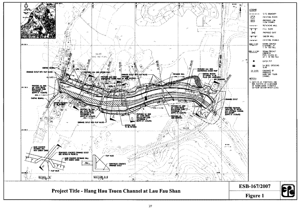
Title : Hang Hau Tsuen Channel at Lau Fau Shan
(
hereinafter known as "the Project" )
Name of Applicant : Civil Engineering and Development Department
(
hereinafter known as "the Applicant")
1. BACKGROUND
1.1
An application (No.
ESB-167/2007) for an Environmental Impact
Assessment (EIA) study brief under section 5(1)(a) of the Environmental Impact
Assessment Ordinance (EIAO) was submitted by the Applicant on 7 June 2007 with
a Project Profile (No. PP-318/2007) for the Project.
1.2
The Project is intended
to alleviate the flooding problem in the area by converting the existing Hang
Hau Tsuen stream between Deep Bay and
Deep Bay Road into an
engineered channel. The proposed
location and layout of the Project are shown in Figure 1. The proposed project works comprise -
(i)
training of Hang Hau
Tsuen stream including construction of a drainage
channel of 370m
in length connecting the downstream ends of Fung Kong Tsuen Channel and San
Hing Tsuen Channel to Deep
Bay;
(ii)
construction
of a25mbox culvert
of 5.5m (w) x 3m (H) beneath the Deep Bay Road and 4 nos. of footbridges across the channel; and
(iii)
provision
of an access road of 3.5 m
in width with passing bays along the northern bank of the channel and footpaths
of 2 m in width on both
sides of the channel.
1.3
The Project is a designated
project by virtue of item I.1(b) (vi) of Schedule 2 of the EIAO. In accordance with item I.1 (b) (vi),
"A
drainage channel or river training and diversion works which discharges or
discharge into an area which is less than 300 m
from the nearest boundary of an existing or planned coastal protection area" is
a designated project. In accordance
with section 5(1)(a), a person who is planning a designated project shall apply
to the Director for an environmental impact assessment study brief to proceed
with an environmental impact assessment study for the project.
1.4 Pursuant
to section 5(7)(a) of the EIAO, the Director of Environmental Protection (the
Director) issues this EIA study brief to the Applicant to carry out an EIA
study.
1.5
The
purpose of the EIA study is to provide information on the nature and extent of
environmental impacts arising from the construction and operation of the Project
and related activities taking place concurrently. This information will contribute to
decisions by the Director on -
(i) the overall
acceptability of any adverse environmental consequences that are likely to
arise as a result of the Project;
(ii) the conditions and
requirements for the detailed design, construction and operation of the Project
to mitigate against adverse environmental consequences wherever practicable;
and
(iii) the acceptability of residual
impacts after implementation of the proposed mitigation measures.
2. OBJECTIVES
OF THE EIA STUDY
2.1 The objectives of the EIA study are as follows -
(i)
to
describe the Project and associated works together with the requirements for
carrying out the Project;
(ii) to identify and describe
the elements of the community and environment likely to be affected by the Project
and/or likely to cause adverse impacts to the Project, including both the
natural and man-made environment;
(iii) to provide information on
consideration of alternatives to avoid and minimize potential environmental
impacts to environmentally sensitive areas and other sensitive uses; to compare
the environmental benefits and dis-benefits of each of different options; to
provide reasons for selecting the preferred option(s) and to describe the part
environmental factors played in the selection of preferred option(s);
(iv) to identify any potential
impacts from point and non-point pollution sources on the identified water
systems and sensitive receivers during the construction and operation stages;
(v)
to
identify and quantify any potential losses and damage to flora, fauna and natural
habitats and to propose measures to avoid or mitigate these impacts;
(vi)
to
identify and quantify any potential landscape
and visual impacts and determine the significance of impacts on sensitive
receivers;
(vii) to propose provision of infrastructure
or mitigation measures so as to minimize pollution, environmental disturbance
and nuisance during construction and operation of the Project;
(viii) to identify, predict and evaluate the residual
environmental impacts (i.e. after practicable mitigation) and the cumulative
effects expected to arise during the construction and operation phases of the Project
in relation to the sensitive receivers and potential affected uses;
(ix)
to identify, assess
and specify methods, measures and standards, to be included in the detailed
design, construction and operation of the Project, which are necessary to
mitigate these environmental impacts and reduce them to the acceptable levels;
(x)
to investigate the
extent of secondary environmental impacts that may arise from the proposed
mitigation measures and to identify constraints associated with the mitigation
measures recommended in the EIA study, as well as the provision of any
necessary modification; and
(xi)
to design and specify
the environmental monitoring and audit requirements, if required, to ensure the
implementation and the effectiveness of the environmental protection and
pollution control measures adopted.
3. DETAILED
REQUIREMENTS OF THE EIA STUDY
3.1 The Purpose
3.1.1 The
purpose of this study brief is to scope the key issues for the EIA study. The Applicant has to demonstrate in the
EIA report that the criteria in the relevant sections of the Technical
Memorandum on EIA Process of the EIAO (hereinafter referred to as the TM) are
fully complied with.
3.2 The Scope
3.2.1 The scope of this EIA study
covers the Project mentioned in section 1.2 above. The EIA study shall address the likely
key issues described below; together with any key issues identified during the
course of the EIA study -
(i)
the potential impact arising from the Project and associated
activities on Hang Hau Tsuen stream and
the coastal protection area in the vicinity, and the assessment shall include
but not be limited to the stream course, stream meander, mangrove, inter-tidal
mudflats and existing ponds within or near to Hang Hau Tsuen stream;
(ii)
the potential noise and air quality impacts to
sensitive receivers during
construction and operation of the Project;
(iii)
the potential aquatic and terrestrial ecological
impacts arising from the Project, including loss of habitats, removal of
vegetation and disturbance to plants and animals. The assessment shall fully address all
direct, indirect and cumulative impacts arising from construction and operation
of the Project on the integrity and viability of the ecosystems of Hang Hau
Tsuen stream and Inner Deep Bay;
(iv)
the potential impacts arising from the Project on the
drainage and hydrology, the water
quality and aquatic ecology of Hang Hau Tsuen stream floodplain, in particular
the potential impacts on the flow regime, water level and water quality on the stream
meanders, mangrove, inter-tidal mudflat habitats and Inner Deep Bay; and
(v)
the potential landscape and visual impacts arising
from the removal of stream meanders, vegetation cover, mangroves and mudflats and
the cutting of bank(s) along channel sides.
3.3
Consideration of Alternatives
Need for the Project
3.3.1 The
Applicant shall provide information on the need for the Project and
justification for the need and scale of the proposed works. The Applicant shall explain clearly the
purpose and objectives of the Project and describe the scenarios with and
without the Project.
Consideration of Alternative
Drainage Options, Channel Alignments and Designs
3.3.2 The
Applicant shall identify feasible alternatives other than the proposed option
presented in the Project Profile (No. PP-318/2007) to alleviate the flooding
problem in the area. In considering
alternative flood alleviation options, channel alignments and lining designs,
the Applicant shall take into account the need to minimize negative effects on Hang
Hau Tsuen stream course, the mangrove colony, nearby fish pond habitats and the
inter-tidal mudflats.
3.3.3 An evaluation system shall be set up to assess the environmental benefits
and dis-benefits of all possible flood alleviation alternatives and channel design
options.
Consideration of
Alternative Construction Methods and Sequences of Works
3.3.4 Having regard to the
cumulative effects of the construction period and the severity of the
construction impacts to the affected sensitive receivers in the vicinity of the
drainage channel, the EIA study shall also explore alternative construction
methods and work sequences for the Project with a view to avoid adverse environmental
impacts to the maximum practicable extent.
A comparison of the environmental benefits and dis-benefits of various
construction methods shall be made.
The Applicant shall take into account the environmental implications of
possible release of heavy metals from mud during excavation works and the potential
water quality impact during the construction phase.
Need for Maintenance Dredging
3.3.5 The Applicant shall investigate any need for maintenance dredging during
the operation stage. If such a need
is identified, the Applicant shall assess and quantify the frequency, the
likely extent of maintenance dredging required and associated potential
environmental impacts.
3.4 Technical
Requirements
3.4.1 The Applicant shall conduct an
EIA study to address all environmental aspects of the activities described in
the scope set out in section 3.2 above subject to the findings of the
evaluation process specified in section 3.3. The EIA study shall be based on the best
and latest information available during the course of the study.
3.4.2 The Applicant shall include in
the EIA report details of the construction programme and methodologies. The Applicant shall clearly state in the
EIA report the time frame and work programmes of the Project and other
concurrent projects, and assess the cumulative environmental impacts from the
Project with all interacting projects, including staged implementation of the
Project.
Use of Relevant Findings of
Approved EIA Reports and Relevant Studies
3.4.3 The Applicant shall review all
previously approved studies and EIA reports which are relevant to the Project
and extract relevant information for the purpose of this study.
3.4.4 The EIA study shall include
the following technical requirements on specific impacts.
3.4.5 Air Quality Impact
3.4.5.1 The Applicant
shall follow the criteria and guidelines as stated in section 1 of Annex 4 and Annex
12 of the TM for evaluating and assessing the air quality impact.
Determination of
Assessment Area
3.4.5.2
The area for air
quality impact assessment shall be defined by a distance of 500m from the boundary of the Project
works site, and may be extended depending on the circumstances and the scale of
the Project. The assessment shall
include but not limited to the existing, planned and committed sensitive
receivers within the assessment area.
3.4.5.3
The Applicant shall
assess the air pollutant concentrations with reference to the relevant sections
of the guidelines attached to this study brief in Appendices A-1 to A-3
or other methodology as agreed by the Director.
3.4.5.4
The air quality
assessment shall be based on the best available information at the time of
assessment. The assessment shall
include the following -
(i)
Background and
Analysis of Activities
(a) Provide
background information relating to air quality issues relevant to the Project.
(b)
Give an account, where
appropriate, of the consideration/ measures that had been taken into account in
the planning of the Project to abate the air pollution impact. That is, the Applicant shall consider alternative
construction methods/phasing programmes to minimize the air quality impact
(c)
Present the background
air quality levels in the assessment area for the purpose of evaluating the cumulative air quality impact.
(ii)
Identification of Air
Sensitive Receivers (ASRs) and Examination of Emission/Dispersion
Characteristics
(a) Identify
and describe representative existing and planned/ committed ASRs that would
likely be affected by the Project, including those earmarked on the relevant
Outline Zoning Plans, Development Permission Area Plans, Outline Development
Plans, Layout Plans and other relevant published land use plans, including
plans and drawings published by Lands Department, and any land use and
development applications approved by Town Planning Board. The Applicant shall select the
assessment points of the identified ASRs such that they represent the worst
impact points of these ASRs. A map
showing the locations and description, including the names and uses of
buildings and the height of the selected assessment points, shall be
given. The separation distances of
these ASRs from the nearest emission sources should also be provided.
(b) Provide
a list of air pollutant emission sources, including any nearby emission sources
which are likely to have impact related to the Project based on the analysis of
the constructional and operational activities of the Project in section 3.4.5.4
(i) above. Examples of construction
stage emission sources include stockpiling, material handling and vehicular
movements on unpaved haul roads on site, etc. Examples of operational stage emission
sources include odour from dredging activities during maintenance. Confirmation of the validity of the
assumptions and the magnitude of the activities (e.g. volume of construction
materials handled) shall be obtained from the relevant government/authorities
and documented.
(c) The
Applicant shall confirm if dredging operation is required during the construction
and operation stages, and, if affirmative, if odour nuisance would arise. In case of odour nuisance arising, the
Applicant shall propose mitigation measures, including good site practices, for
implementation.
(iii)
Impact Assessment
Constructional
Phase Impact
(a)
The Applicant shall
follow the requirements of the Air Pollution Control (Construction Dust)
Regulation to ensure constructional dust impacts are controlled within the
relevant standards as stipulated in section 1 of Annex 4 of the TM. A monitoring and audit
program shall be implemented during the construction stage to verify the
effectiveness of the control measures and to ensure that the construction dust
levels are brought under control.
If the Applicant anticipates significant construction dust impact that
will likely cause exceedance of the recommended limits in the TM at the ASRs
despite incorporation of dust control measures, a quantitative assessment shall
be carried out to evaluate the construction dust impact at the identified
ASRs. The Applicant shall follow
the methodology set out in section 3.4.5.4
(iv) and (v) below when carrying out the quantitative assessment.
Operational
Phase Impact
(b) The Applicant shall assess the
expected air pollution impacts at the identified ASRs based on the emission
sources identified in section .4 (ii) (b) above. The Applicant shall propose suitable
measures to ensure that the air quality impacts are brought under control.
(iv) Quantitative
Assessment Methodology
(a) If a
quantitative assessment is required, the Applicant shall conduct the
quantitative assessment with reference to relevant sections of modelling
guidelines in Appendices A1 to A3 or any other methodology as agreed
with the Director. The specific
methodology must be documented to such level of details (preferably with tables
and diagrams) to allow the readers of the assessment report to grasp how the
model is set up to simulate the situation at hand without referring to the
model input files. Detailed
calculation of the pollutant emission rates shall be presented in the EIA
report. The Applicant must ensure
consistency between the text description and the model files at every stage of
submission. In case of doubt, the
Applicant shall seek and obtain prior agreement of the Director on the specific
modelling details.
(b) The
Applicant shall identify the key/representative air pollutant parameters related
to activities identified in section 3.4.5.4
(i) above (types of pollutants and the averaging time concentration) to be
evaluated and provide explanation for choosing these parameters for assessment
of the air quality impact of the Project.
(c) The Applicant shall calculate the cumulative air quality impact at the identified ASRs and compare these results against the criteria set out in section 1 of Annex 4 in the TM. The predicted air quality impacts (both unmitigated and mitigated) shall be presented in the form of summary tables and pollution contours, to be evaluated against the relevant air quality standards and examination of the land use implications of these impacts. Plans of suitable scale should be used for presentation of pollution contours for determining buffer distances required.
(v) Mitigating
Measures for Non-compliance
(a) The
Applicant shall propose remedies and mitigating measures, where the predicted
air quality impact exceeds the criteria set out in section 1 of Annex 4 in the TM. These measures and any constraints on
future land use planning shall be agreed with the relevant government
departments/authorities and documented.
The Applicant shall demonstrate quantitatively that the resultant
impacts after incorporation of proposed mitigating measures will comply with
the criteria stipulated in section 1 of Annex 4 in the TM.
(vi) Submission
of Model Files
(a) All input and output file(s) of the model run(s) shall be submitted to the Director in an electronic format.
3.4.6
Noise Impact
3.4.6.1 The Applicant
shall follow the criteria and guidelines as stated in Annex 5 and Annex 13 of
the TM for evaluating and assessing the noise impact.
3.4.6.2 The noise impact assessment for the Project shall include the following -
(i) Determination
of Assessment Area
(a) The area
for the noise impact assessment shall include all areas within 300m from the Project site boundary or
alternative Project alignment identified in the EIA study. Subject to the agreement of the Director,
the assessment area could be reduced accordingly if the first layer of noise
sensitive receivers, closer than 300m
from the Project site boundary, provides acoustic shielding to those receivers
further from the Project site.
Subject to the agreement of the Director, the assessment area shall be
expanded to include noise sensitive receivers (NSRs) at distances over 300m from the Project site boundary,
which would be affected by the Project.
(ii) Provision
of Background Information and Existing Noise Levels
(a) The
Applicant shall provide all background information relevant to the Project,
including relevant previous or current studies. Unless required for determining planning
standards, it will not be necessary to investigate the existing noise levels.
(iii) Identification
of Noise Sensitive Receivers
(a) The
Applicant shall refer to Annex 13 of the TM when identifying noise sensitive
receivers (NSRs). The NSRs shall
include all existing NSRs and all planned/committed noise sensitive
developments and uses earmarked on the relevant Outline Zoning Plans, Development
Permission Area Plans, Outline Development Plans, Layout Plans and other relevant
published plans, including plans and drawings published by Lands Department,
and any land use and development applications approved by Town Planning
Board. Photographs of the existing
NSRs shall be appended to the EIA report.
(b) The
Applicant shall select assessment points to represent all identified NSRs for
carrying out a quantitative noise assessment described below. The assessment points shall be agreed
with the Director prior to the quantitative noise assessment. A map showing the location and
description, such as names and uses of buildings, and the floor of each and
every selected assessment point, shall be given. For planned noise sensitive land uses
without committed site layouts, the Applicant shall use the relevant planning
parameters to work out representative site layouts for operational noise
assessment purpose. Such
assumptions together with any constraints identified, such as setback of
building, building orientation and extended podium, shall be agreed with the
relevant responsible parties including Planning Department and Lands
Department.
(iv) Provision
of an Emission Inventory of the Noise Sources
(a) The
Applicant shall provide an inventory of noise sources including representative construction
equipment for construction noise assessment, and traffic flow for operational
noise assessment as appropriate. Confirmation
of the validity of the inventory shall be obtained from the relevant government
departments/authorities and documented in the EIA report.
(v) Construction
Noise Assessment
(a)
The assessment shall
cover the cumulative noise impacts due to construction works of the Project and
other concurrent projects identified during the course of the EIA study.
(b)
The Applicant shall
carry out an assessment of noise impact arising from construction of the
Project (excluding percussive piling) during day time, i.e. 7 a.m. to 7 p.m. on weekdays other than
general holidays, in accordance with the methodology stipulated in paragraphs 5.3
and 5.4 of Annex 13 of the TM. The
criteria in Table 1B of Annex 5 of the TM shall be adopted in the assessment. In case blasting works are involved, it
shall be carried out, as far as practicable, outside the sensitive hours of 7
p.m. to 7 a.m. on Monday to
Saturday and any time on a general holiday, including Sunday. For blasting that must be carried out
during the above mentioned sensitive hours, the noise impact from the removal
of debris and rocks shall be fully assessed and adequate mitigation measures
shall be recommended to reduce the noise impact.
(c) To minimize
the construction noise impact, alternative construction methods to replace
percussive piling shall be explored and recommended as far as practicable.
(d) If the
unmitigated construction noise levels are found to exceed the relevant
criteria, the Applicant shall propose practicable direct mitigation measures
(including but not limited to movable barriers, enclosures, quieter alternative
methods, re-scheduling and restricting hours of operation of noisy task) to
minimize the impact. If the
mitigated noise levels still exceed the relevant criteria, the duration of the
noise exceedance at the affected NSRs shall be given.
(e) The Applicant
shall formulate a reasonable construction programme as far as practicable, such
that no work will be required to be undertaken in the restricted hours as
defined in the Noise Control Ordinance (NCO). In case the Applicant needs to evaluate
whether construction works in the restricted hours as defined in the NCO are
feasible or not in the context of programming construction works, reference
shall be made to the relevant technical memoranda issued under the NCO. In case the Applicant considers that
there is an unavoidable need to conduct certain type of construction works
during the restricted hours, detailed justifications should be provided with
the assessment of the degree and duration of the noise impact. Regardless of the results of
construction noise impact assessment for restricted hours, the Noise Control
Authority will process Construction Noise Permit (CNP) application, if
necessary, based on the NCO, the relevant technical memoranda issued under the
NCO, and the contemporary conditions/situations. This aspect should be explicitly stated
in the noise chapter and the conclusions and recommendation chapter in the EIA
report.
(vi) Operational
Noise Assessment
The
Applicant shall confirm in the EIA study if the proposed access road(s) will be
open for use by channel maintenance vehicles only or open to use by the
public. In the case that the
proposed access road(s) will be open to use by the public in addition to maintenance
vehicles, the Applicant shall conduct operational traffic noise impact
assessment in accordance with the requirements set out below.
(a) Road
Traffic Noise
(a1) Calculation
of Noise Levels
The Applicant shall analyse the scope of the proposed road alignment(s)
to identify the road sections for the purpose of traffic noise impact
assessment. In determining whether
the traffic noise impact due to a road is considered significant, detailed
information with respect to factors including at least change of nature of
road, change of alignment and change of traffic capacity or traffic composition
shall be assessed. The traffic noise impact shall be considered significant if
the traffic noise level with the Project is greater than that without the Project
at the design year by 1.0 dB(A) or more. Figures showing extents
of new roads and existing roads shall be provided in the EIA report.
The
Applicant shall calculate the expected road traffic noise using methods
described in the U.K. Department of Transport¡¦s ¡§Calculation of Road Traffic
Noise¡¨ (1988). Calculations of
future road traffic noise shall be based on the peak hour traffic flow in
respect of the maximum traffic projection within a 15 years period upon
commencement of operation of the Project. The Applicant shall calculate traffic
noise levels in respect of each road section and the overall noise levels from
combined road sections (both new and existing) at NSRs. The EIA report shall contain sample
calculations and input parameters for at least 10 assessment points as
requested by the Director. The
Applicant shall provide the input data set of the traffic noise model in the
format of electronic files in the EIA.
Furthermore, the Applicant shall prepare and provide drawings (i.e.
road-plots of the traffic noise model) of appropriate scale to show the road
segments, topographic barriers, and assessment points of sensitive receivers
input into the traffic noise model.
The Applicant shall provide input data sets of traffic noise prediction model adopted in the EIA study as requested by the Director for the following scenarios -
(i)
the unmitigated scenario in the assessment year;
(ii)
the mitigated scenario in the assessment year; and
(iii) the
prevailing scenario for indirect technical remedies eligibility assessment.
The data shall be in an electronic
text file (ASCII format) containing road segments, barriers and noise sensitive
receivers information. The data
structure of the above file shall be agreed with the Director. CD-ROM(s) containing the above data shall
be attached in the EIA report.
(a2) Presentation
of Noise Levels
The Applicant shall present the prevailing and
future noise levels in L10 (1 hour) at the NSRs at various
representative floor levels (in m P.D.) on tables and plans of suitable scale.
A
quantitative assessment at the NSRs for the proposed road alignments shall be
carried out and compared against the criteria set out in Table 1A of Annex 5 of the TM. The potential noise impact of the
Project shall be quantified by estimating the total number of dwellings,
classrooms and other noise sensitive elements that will be exposed to noise
levels exceeding the criteria set in Table 1A
of Annex 5 in the TM.
(a3) Proposals
for Noise Mitigation Measures
After rounding of the predicted noise levels according to the U.K.
Department of Transport's "Calculation of Road Traffic Noise"(1988),
the Applicant shall propose direct mitigation measures in all situations where
the predicted traffic noise level due to the road sections exceeds the criteria in
Table 1A of Annex 5 in the TM by 1 dB(A) or more. The direct mitigation measures listed
under section 6.1, Annex 13 of the TM, such as the option of alternative land
use arrangement, shall be thoroughly explored and evaluated with a view to reducing
the noise level at the NSRs concerned to the level meeting the relevant noise
criteria. Also, the feasibility,
practicability, programming and effectiveness of the recommended mitigation
measures should be assessed in accordance with section 4.4.2(k)
of the TM. Specific reasons for not
adopting certain direct mitigation measures in the design to reduce the traffic
noise to a level meeting the criteria in the TM or to maximize the protection
for NSRs as far as possible shall be clearly and specifically quantified and
laid down in the EIA report.
Sections of barriers proposed to protect the existing NSRs shall be
differentiated clearly from those proposed for protection of future or planned
NSRs as the latter is only required to be constructed before occupation of the
planned NSRs. To facilitate the
phased implementation of the barriers under this principle, a barrier inventory
showing intended NSRs (i.e. existing NSRs as distinct from planned NSRs) to be
protected by different barrier sections to achieve different extent of noise
reduction (to be quantified in terms of how many dB(A)) should be provided. The total number of
dwellings, classrooms and other noise sensitive element that will be benefited
by the provision of direct technical remedies shall be provided. In order to clearly present the extents/locations of the
recommended noise mitigation measures, plans prepared from 1:1,000 or 1:2,000
survey maps showing the mitigation measures (e.g. enclosures/barriers, low
noise road surfacing, etc.) shall be included in the EIA report.
The total
number of dwellings, classrooms and other noise sensitive elements that will
still be exposed to noise above the criteria with the implementation of all
recommended direct technical remedies shall be quantified. The Applicant shall provide in the EIA report the information
of the recommended noise mitigation measures (such as barrier types, nominal
dimensions at different cross-sections, extents/locations, lengths, mPD levels
of barriers) in an electronic format as agreed by the Director.
In case where a number of NSRs cannot be protected by the recommended
direct mitigation measures, the Applicant shall identify and estimate the total
number of existing dwellings, classrooms and other noise sensitive elements
which may qualify for indirect mitigation measures, the associated costs and
any implications for such implementation. For the purpose of determining the
eligibility of the affected premises for indirect technical remedies, reference
shall be made to the following set of three criteria -
(i) the
predicted overall noise level from the road sections together with other
traffic noise in the vicinity must be above a specified noise level ( e.g. 70
dB(A ) for domestic premises and 65 dB(A) for education institutions, all in L10(1hr)
);
(ii)
the predicted overall
noise level is at least 1.0 dB(A) more than the prevailing traffic noise level,
i.e. the total traffic noise level existing before commencement of the works to
construct the road; and
(iii)
the contribution of
the road sections to the increase in the predicted overall noise level from the
new road must be at least 1.0 dB(A).
(vii)
Assessment of Side
Effects and Constraints
The
Applicant shall identify, assess and propose means to minimize any side effects
and to resolve any potential constraints due to the inclusion of any
recommended direct mitigation measures.
(viii)
Evaluation of
Constraints on Planned Noise Sensitive Developments/ Land uses
For planned
noise sensitive uses which will still be affected even with practicable direct
mitigation measures in place, the Applicant shall propose, evaluate and confirm
the practicability of additional measures within the planned noise sensitive
uses and shall make recommendations on how these noise sensitive uses will be
designed for the information of relevant parties.
The
Applicant shall take into account agreed environmental requirements/constraints
identified in the EIA study to assess the development potential of concerned
sites, which shall be made known to the relevant parties.
3.4.7 Water Quality Impact
3.4.7.1 The Applicant shall follow the
criteria and guidelines as stated in Annex 6 and Annex 14 of the TM for
evaluating and assessing water pollution.
3.4.7.2 The
study area for the water quality impact assessment shall include all areas
within 300m from the Project site
boundary, including but not limited to Hang Hau Tsuen stream catchment area and
Inner Deep Bay. This assessment area could be extended
to include other areas such as stream courses and the associated water system
in the vicinity being impacted during the course of the EIA study if found
justifiable.
3.4.7.3
The
Applicant shall identify and analyze physical, chemical and biological
disruptions of marine, estuarine or fresh water system(s), drainage system, catchment
area(s), storm water channel and coastal water arising from the construction
and operation of the Project.
3.4.7.4
The
Applicant shall address water quality impacts due to construction and operation
(including maintenance works) of the Project. Essentially, the assessment shall
address the following -
(i)
Collect
and review background information on the affected existing and planned water
systems, their respective catchments and sensitive receivers which might be
affected by the Project;
(ii)
Characterize water quality of the water systems, their
respective catchments and sensitive receivers which might be affected by the Project
based on the existing best available information or through appropriate site
survey and tests;
(iii)
Identify
and analyze relevant existing and planned future activities, beneficial uses and
water sensitive receivers related to the affected water system(s). The Applicant shall refer to,
inter alia, those developments and
uses specified in the relevant Outline Zoning Plans, Outline Development Plans
and Layout Plans, and any other relevant published landuse plans;
(iv)
Identify pertinent water quality objectives and establish other
appropriate water quality criteria or standards for the water system(s) and all
the sensitive receivers in section 3.4.7.4
(i), (ii) & (iii), including ecological sensitive receivers for the
assessment covered in section 3.4.9 below;
(v)
Review the specific
construction methods and configurations, and operation of the Project
(including the proposed access road, footpaths, and maintenance works). Identify any alteration of the existing water courses, meander, natural
streams, shoreline or bathymetry, flow regimes and ground water levels;
(vi)
Identify and quantify the existing and likely future water pollution
sources and loading. An emission inventory on the quantities
and characteristics of these existing and likely future pollution sources in
the study area shall also be provided.
Field investigation and laboratory test shall be conducted as
appropriate to fill relevant information gaps;
(vii)
Assess the cumulative impacts due to other related concurrent and planned
projects, and activities or pollution sources in Lau Fau Shan area along the
identified water system(s) and sensitive
receivers that may have a bearing on the environmental acceptability of the
Project;
(viii)
Assess and evaluate
any potential water quality impacts on the identified water system(s),
respective catchments and sensitive receivers due to sewage arising from the
construction stage. Any effluent
generated will require appropriate collection, treatment and disposal to within
the standards and objectives and criteria established in section
3.4.7.4
(iv) above;
(ix)
Assess and evaluate any potential storm water
and construction runoff impacts on the water system(s), respective catchments
and sensitive receivers during the construction stage and operational
maintenance works (such as regular desilting and/or dredging) as to reduce the
water quality impacts to within the standards, objectives and criteria
established in section 3.4.7.4 (iv) above. Best management practices shall be
recommended to reduce any potential impacts arising from storm water runoff
during both construction and operation phases;
(x)
Assess the
pattern of the sediment deposition and the potential increase in turbidity and
suspended solids levels in the water column due to the disturbance of sediments
during dredging, if any. The
potential for the release of contaminants during dredging shall also be
addressed using the chemical testing results derived from sediment samples
collected on site and relevant historic data;
(xi)
Proposals
for effective and practicable infrastructure upgrading or provision, water
pollution prevention and mitigation measures to be implemented during the
construction and operation stages to reduce water quality impacts to within the
standards. Requirements to be
incorporated in the Project contract document shall also be proposed;
(xii)
Best
management practices to reduce storm water and non-point source pollution shall
be investigated and proposed as appropriate;
(xiii)
Evaluate
and quantify residual impacts on the affected water system(s) and sensitive
receivers with regard to the appropriate water quality criteria, standards or
guidelines; and
(xiv)
Specify an emergency contingency plan for the construction phase of the
Project to contain and remove accidental spillage along the channel, access
road(s) /haul road(s) at short notice and to prevent or to minimize the
quantities of contaminants from the stream water and sensitive habitats.
3.4.8 Waste Management Implications
3.4.8.1 The Applicant
shall follow the criteria and guidelines as stated in Annex 7 and Annex 15 of
the TM for evaluating and assessing waste management implications.
3.4.8.2 The assessment of
waste management implications shall cover the following -
(i) Analysis
of Activities and Waste Generation
(a) Identification
of the quantity, quality and timing of the waste arising as a result of the
construction and operation activities, based on the sequence and duration of
these activities.
(ii) Proposal
for Waste Management
(a) Prior to
considering the disposal options for various types of wastes, opportunities for
reducing waste generation and on-site or off-site re-use shall be fully evaluated. Measures, which can be taken in the
planning and design stages, e.g. by modifying the design approach, and in the
construction stage for maximizing waste reduction shall be separately
considered.
(b) After
considering all the opportunities for reducing waste generation and maximizing
re-use, the types and quantities of the wastes required to be disposed of as a
consequence shall be estimated and the disposal options for each type of waste
shall be described in detail. Pre-treatment
processes for slurry before disposal shall be addressed in detail. The disposal method recommended for each
type of waste shall take into account the result of the assessment in section.2
(ii) (c) below.
(c) The impact caused by handling (including labelling, packaging and storage), collection, and disposal of wastes shall be addressed in detail and appropriate mitigation measures proposed. This assessment shall cover the following areas -
• potential
hazard;
•
air and odour emissions;
•
noise;
• wastewater
discharge; and
•
public transport.
(iii) Dredging,
Filling and Dumping
(a)
Identification
and quantification as far as practicable of all dredging; fill extraction,
filling, reclamation, mud/sediment transportation and disposal activities and
requirements shall be conducted.
Potential fill source and dumping ground to be involved shall also be
identified. Field investigation,
sampling and chemical and biological laboratory tests to characterize the
sediment/mud concerned shall be conducted as appropriate. The ranges of parameters to be analysed;
the number, type and methods of sampling; sample preservation; chemical and
biological laboratory test methods to be used shall be agreed with the Director
(with reference to section (c) of the TM)
prior to commencement of the tests.
The categories of sediments, which are to be disposed of in accordance
with a permit granted under the Dumping at Sea Ordinance (DASO), shall be
identified by both chemical and biological tests and their quantities shall be
estimated. If the presence of any
serious contaminated sediment, which requires special treatment/disposal, is
confirmed, the Applicant shall identify the most appropriate treatment and/or
disposal arrangement and demonstrate its feasibility.
(b)
Identification and evaluation of
the best practical dredging methods to minimize dredging and dumping
requirements and demand for fill sources based on the criterion that the
existing marine mud shall be left in place and not to be disturbed as far as
possible.
3.4.9
Ecological
Impact (Both Terrestrial and Aquatic)
3.4.9.1 The
Applicant shall follow the criteria and guidelines as stated in Annex 8 and
Annex 16 of the TM for evaluating and assessing ecological impact. The assessment area for the purpose of
terrestrial ecological assessment shall include all areas within 500m from the boundary of the works
areas, or the area likely to be impacted by the Project. For aquatic ecology, the assessment area
shall be the same as for water quality assessment described in section 3.4.7.2.
3.4.9.2 In
the ecological impact assessment, the Applicant shall examine the flora, fauna
and other components of the ecological habitats within the assessment
area. The aim shall be to protect,
maintain or rehabilitate the natural environment. The assessment shall identify and
quantify as far as possible the potential ecological impacts associated with
the Project, including the impacts of any haul roads and temporary access. The potential impact on water quality
and aquatic ecology from the discharge of storm water into Inner Deep
Bay waters during the operational phase
shall also be addressed.
3.4.9.3 The assessment shall include the following -
(i)
Review
of the findings of relevant studies and collating all the available information
regarding the ecological characters of the assessment area;
(ii) Evaluation
of the information collected and identification of any information gap relating
to the assessment of potential ecological impacts to the terrestrial and
aquatic environment;
(iii) Carrying
out necessary field surveys (the duration of which shall be at least 6 months
covering the winter migratory bird season) and investigations to verify the
information collected, fill the information gaps identified and fulfil the
objectives of the EIA study;
(iv) Establishing
a general ecological profile and describing the characteristics of each habitat
found; major information to be provided shall include ¡V
(a)
Description of the physical environment;
(b)
Preparation of habitat maps of suitable scale (1:1000 to 1:5000) showing
the types and locations of habitats in the assessment area;
(c)
Definition and characterization of the ecological characteristics of each
habitat type, including size, vegetation type, species present, dominant
species found, species diversity and abundance, community structure,
seasonality and inter-dependence of the habitats and species, and presence of
any features of ecological importance;
(d)
Presentation of representative colour photos of each habitat type and of
any important ecological features identified; and
(e)
Listing the species found that are rare, endangered and/or listed under
local legislation, international conventions for conservation of
wildlife/habitats or red data books.
(v)
Investigation and description of the existing wildlife uses of various habitats
with special attention to those wildlife groups and habitats with conservation
interest including -
(a)
the coastal protection area near Hang Hau Tsuen;
(b)
the natural stream course and meanders of Hang Hau Tsuen stream;
(c)
the ponds, inter-tidal mudflats and mangrove at or near the Project area;
(d)
avifauna in particular waterbirds; and
(e)
any other habitats and wildlife groups identified as having special
conservation interest by the study.
(vi) Description
of all recognized sites of conservation importance in the proposed development
site and its vicinity and assessment of whether these sites will be affected by
the proposed development;
(vii) Using
suitable methodology, identification and quantification as far as possible of
any direct, indirect, on-site, off-site, primary, secondary and cumulative
ecological impacts such as destruction of habitats, reduction of species
abundance/diversity, loss of feeding, nesting and/or breeding grounds,
reduction of ecological carrying capacity, habitat fragmentation; and in
particular the following -
(a)
ecological impacts of potential loss of areas of conservation interest
such as natural stream courses, fish ponds, inter-tidal mudflats and mangrove;
(b)
disturbance to wildlife during the construction stage in particular the
impacts on waterbirds;
(c)
impacts due to the potential sedimentation to the inter-tidal mudflats and
Deep Bay during the construction stage;
(d)
operational impacts on aquatic life and other wildlife in Deep Bay
through periodic storm discharges at the portal; and
(e)
cumulative impacts due to other planned and committed development projects
at or near the Project area.
If
off-site mitigation is considered necessary to mitigate the environmental
impact, the guidelines and requirements laid down in Annex 16 of the TM should
be followed.
(viii) Evaluation
of the significance and acceptability of the ecological impacts identified
using well-defined criteria;
(ix)
Recommendation of all possible alternatives, such as modifications of channel
alignment, layout and design and practicable mitigation measures to avoid,
minimize and/or compensate for the adverse ecological impacts identified, such
as reinstatement of habitats temporarily affected by the proposed development
to its original state and if appropriate with some enhancement features;
(x)
Evaluation of the feasibility and effectiveness of the recommended
mitigation measures and definition of the scope, type, location, implementation
arrangement, resources requirement, subsequent management and maintenance of such
measures;
(xi)
Determination and quantification as far as possible of the residual
ecological impacts after implementation of the proposed mitigation measures;
(xii)
Evaluation of the severity and acceptability of the residual ecological
impacts using well-defined criteria; and
(xiii) Review of the need for and recommendation for any
ecological monitoring programme required.
3.4.10 Fisheries Impact
3.4.10.1 The Applicant
shall follow the criteria and guidelines as specified in Annex 9 and Annex 17
of the TM for assessing fisheries impact.
3.4.10.2 The assessment area shall include 500m from the limit of the Project site
boundary and any areas likely to be impacted by the Project. Special attention shall be given to the
surrounding fish ponds and the oyster beds in Lau Fau Shan and Inner Deep Bay.
3.4.10.3 The study
shall review and collate the existing information to provide adequate and
accurate data for prediction and evaluation of impacts of the Project on
fisheries. Any data gap shall be
identified and the need for field surveys shall be determined. If field surveys are considered
necessary, appropriate methodology, duration and timing of the surveys shall be
recommended to provide the required data.
3.4.10.4 The fisheries
impact assessment shall include the following major tasks -
(i)
Description of
the physical environmental background;
(ii)
Description and
quantification of the existing fisheries activities (e.g. pond culture and
oyster farming);
(iii)
Description and
quantification of the existing fisheries resources;
(iv)
Identification of
parameters (e.g. water quality parameters) and areas that are important in the
fisheries aspect;
(v)
Identification
and quantification of any direct, indirect, on-site and off-site impacts to
fisheries during the construction and operation phases (e.g. loss of fish
ponds/oyster beds and temporary occupied areas);
(vi)
Evaluation of
impacts and proposals for any practical alternatives or mitigation measures to
prevent or minimize adverse impacts on fisheries; and
(vii)
Determination of any
need for fisheries monitoring and, if necessary, recommendation of a monitoring
and audit programme.
3.4.11
Landscape and Visual Impact
3.4.11.1 The Applicant
shall follow the criteria and guidelines as stated in section 1 of Annex 10 and
Annex 18 of the TM for evaluating and assessing landscape and visual impacts of
the Project, including any above ground structures and work areas associated
with the Project. The Landscape and
visual impacts during both construction and operation phases within the
assessment area shall be assessed.
3.4.11.2
The area for landscape impact
assessment shall include all areas within 500m
of the work limit of the Project while the area for the visual impact
assessment shall be defined by the visual envelope of the Project.
3.4.11.3
The Applicant shall review relevant Outline
Development Plan(s), Outline Zoning Plan(s) (OZP) such as Lau Fau Shan &
Tsim Bei Tsui OZP and Ha Tsuen OZP, layout plan(s), other published land use
plans, planning briefs and studies such as the North West New Territories (Yuen
Long District) Development Statement, which may identify areas of high
landscape value and recommended green belt and coastal protection area
designations. Any guidelines on
landscape strategy, landscape framework, urban design concept, building height
profiles, designated view corridors, open space network and landscape link that
may affect appreciation of the Project shall also be reviewed. The aim is to gain an insight into the future
outlook of the area affected so as to assess whether the Project can fit into
the surrounding setting. Any
conflict with statutory land use plan(s) shall be highlighted and appropriate
follow-up action shall be recommended.
3.4.11.4The
Applicant shall describe, appraise, analyze and evaluate the existing landscape
resources and character of the assessment area. A system should be derived for judging
the significance of the landscape and visual impact as required under the TM. The sensitivity of the landscape
framework and its ability to accommodate change shall be particularly focused
on. The Applicant shall identify
the degree of compatibility of the Project with the existing and planned
landscape setting. The landscape
impact assessment shall quantify the potential landscape impact as far as
possible so as to illustrate the significance of such impacts arising from the
Project. Clear mapping of the
landscape impact is required. A tree
survey shall be carried out and the impacts on existing trees shall be
addressed.
3.4.11.5The Applicant shall assess the visual impacts of the
proposed project. Clear
illustration including mapping of visual impact is required. The assessment shall include the
following -
(i)
identification
and plotting of visual envelope of the Project within the assessment area;
(ii)
identification
of the key groups of sensitive receivers within the visual envelope with regard
to views from both ground/sea level and elevated vantage points;
(iii)
description
of the visual compatibility of the Project such as channel walls and associated
access road(s), footbridge(s) and footpath(s) with the surrounding and the
planned setting, and interference with key views of the adjacent areas; and
(iv) identification of the severity of visual impacts in terms of distance, nature and number of sensitive receivers. The visual impacts of the Project with and without mitigation measures shall be included so as to demonstrate the effectiveness of the proposed mitigation measures.
3.4.11.6
The
Applicant shall evaluate the merits of preservation in totality, in parts or
total destruction of existing landscape.
In addition, alternative alignment, design and construction method that
would avoid or reduce the landscape and visual impact shall be evaluated for
comparison before adopting other mitigation or compensatory measures to alleviate
the impacts. The mitigation
measures proposed shall not only be concerned with damage reduction but shall
also include consideration of potential enhancement of existing landscape. The Applicant shall recommend mitigation
measures to minimize the adverse effects identified above, including provision
of a landscape design.
3.4.11.7 The mitigation measures shall also include preservation of
vegetation, transplanting of mature trees, provision of screen planting,
re-vegetation of disturbed land, compensatory planting, design of structures,
provision of finishes to structures, colour scheme and texture of material used
and any measures to mitigate the disturbance of the existing land use. Parties shall be identified for the on
going management and maintenance of the proposed mitigation works to ensure
their effectiveness throughout the operation phase of the Project. A practical programme and funding
proposal for the implementation of the recommended measures shall be provided.
3.4.11.8 Annotated illustration materials such as coloured perspective
drawings, plans and section/elevation diagrams, oblique aerial photographs,
photographs taken at vantage points, and computer-generated photomontage shall
be adopted to fully illustrate the landscape and visual impacts of the Project
to the satisfaction of the Director. The Applicant shall record the technical
details in preparing the illustration, which may need to be submitted for
verification of the accuracy of the illustration.
4. ENVIRONMENTAL
MONITORING & AUDIT (EM&A) REQUIREMENTS
4.1 The
Applicant shall identify in the EIA study if there is a need for EM&A
activities during construction and operation of the Project and, if
affirmative, define the scope of the EM&A requirements for the Project in
the EIA study.
4.2 Subject
to the confirmation of the EIA study findings, the Applicant shall comply with
the requirements as stipulated in Annex 21 of the TM. The Applicant shall also propose
real-time reporting of monitoring data for the Project through a dedicated
internet website.
4.3 The
Applicant shall prepare a Project Implementation Schedule, in the form of a
checklist as shown in Appendix B attached to this study brief, containing
all the EIA study recommendations and mitigation measures with reference to the
implementation programme. The
Project Implementation Schedule shall include the explicit agreement reached between
the Applicant and relevant parties on the responsibility for funding,
implementation, management and maintenance of mitigation measures. Alternatively, the Project
Implementation Schedule shall include an undertaking from the Applicant to
assume the responsibility of those mitigation measures until an agreement is
reached between the Applicant and relevant parties on the funding,
implementation, management and maintenance of mitigation measures.
5. SUMMARY
OF ENVIRONMENTAL OUTCOMES
5.1 The
EIA report shall contain a summary of the key environmental outcomes arising
from the EIA study, including the population and environmentally sensitive
areas protected, environmentally friendly designs recommended, key
environmental problems avoided, compensation areas included and the
environmental benefits of environmental protection measures recommended.
6. DURATION
OF VALIDITY
6.1 If
the EIA study does not commence within 36 months after the date of issue of
this study brief, the Applicant shall apply to the Director for a fresh EIA
study brief before commencement of the EIA study.
7. REPORT
REQUIREMENTS
7.1 In
preparing the EIA report, the Applicant shall refer to Annex 11 of the TM for
the contents of an EIA report. The
Applicant shall also refer to Annex 20 of the TM, which stipulates the
guidelines for the review of an EIA report.
7.2 The
Applicant shall supply the Director with the following number of copies of the
EIA report and the executive summary -
(i) 50
copies of the EIA report in English and 80 copies of the executive summary
(each bilingual in both English and Chinese) as required under section 6(2) of
the EIAO to be supplied at the time of application for approval of the EIA report.
(ii) When
necessary, any addendum to the EIA report and the executive summary submitted
in accordance with section 7.2 (i) above as
required under section 7(1) of the EIAO to be supplied upon advice by the Director
for public inspection.
(iii) 20
copies of the EIA report in English and 50 copies of the executive summary
(each bilingual in both English and Chinese) with or without Addendum as
required under section 7(5) of the EIAO to be supplied upon advice by the
Director for consultation with the Advisory Council on the Environment.
7.3 The
Applicant shall, upon request, make additional copies of the above documents
available to the public, subject to payment by the interested parties of full
costs of printing.
7.4 In
addition, to facilitate public inspection of the EIA report via the EIAO
Internet Website, the Applicant shall provide electronic copies of both the EIA
report and the executive summary prepared in Hyper Text Markup Language (HTML)
(version 4.0 or later) and in Portable Document Format (PDF) version 4.0 or
later), unless otherwise agreed by the Director. For the HTML version, a content page
capable of providing hyperlinks to each section and sub-section of the EIA report
and the executive summary shall be included in the beginning of the document. Hyperlinks to all figures, drawings and
tables in the EIA report and executive summary shall be provided in the main
text from where the respective references are made. All graphics in the report shall be in
interlaced GIF format unless otherwise agreed by the Director.
7.5 The
electronic copies of the EIA report and the executive summary shall be
submitted to the Director at the time of application for approval of the EIA report.
7.6
When the EIA report
and the executive summary are made available for public inspection under
section 7(1) of the EIAO, the content of the electronic copies of the EIA report
and the executive summary must be the same as the hard copies and the Director
shall be provided with the most up to date electronic copies.
7.7 To
promote environmentally friendly and efficient dissemination of information,
both hard copies and electronic copies of future EM&A reports recommended
by the EIA study shall be required and their format shall be agreed by the
Director.
8. OTHER
PROCEDURAL REQUIREMENTS
8.1 If
there is any change in the name of the Applicant for this EIA study brief, the
Applicant mentioned in this study brief must notify the Director immediately.
8.2 If
there is any key change in the scope of the Project mentioned in section 1.2 of
this EIA study brief and in the Project Profile (No. PP-318/2007), the
Applicant must seek confirmation from the Director in writing on whether or not
the scope of issues covered by this EIA study brief can still cover the key
changes, and the additional issues, if any, that the EIA study must also
address. If the changes to the Project
fundamentally alter the key scope of the EIA study brief, the Applicant shall
apply to the Director for a fresh EIA study brief.
July 2007
Environmental Assessment Division
Environmental Protection Department