Environmental Impact Assessment Ordinance (Cap. 499),
Section 5(7)
Environmental
Impact Assessment Study Brief No. ESB-126/2005
(hereinafter
known as the "Project")
Name
of Applicant : Castle
Peak Power Company Limited
(hereinafter
known as the "Applicant")
1. BACKGROUND
1.1 An application
(No. ESB-126/2005) for an Environmental Impact Assessment (EIA) study brief
under section 5(1) of the Environmental Impact Assessment Ordinance (EIAO) was
submitted by the Applicant on 13 May 2005 with a Project Profile (No. PP-126/2005)
(the Project Profile).
1.2
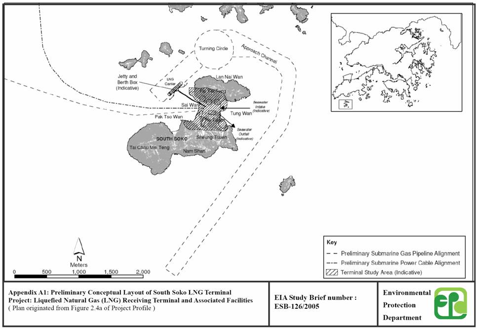
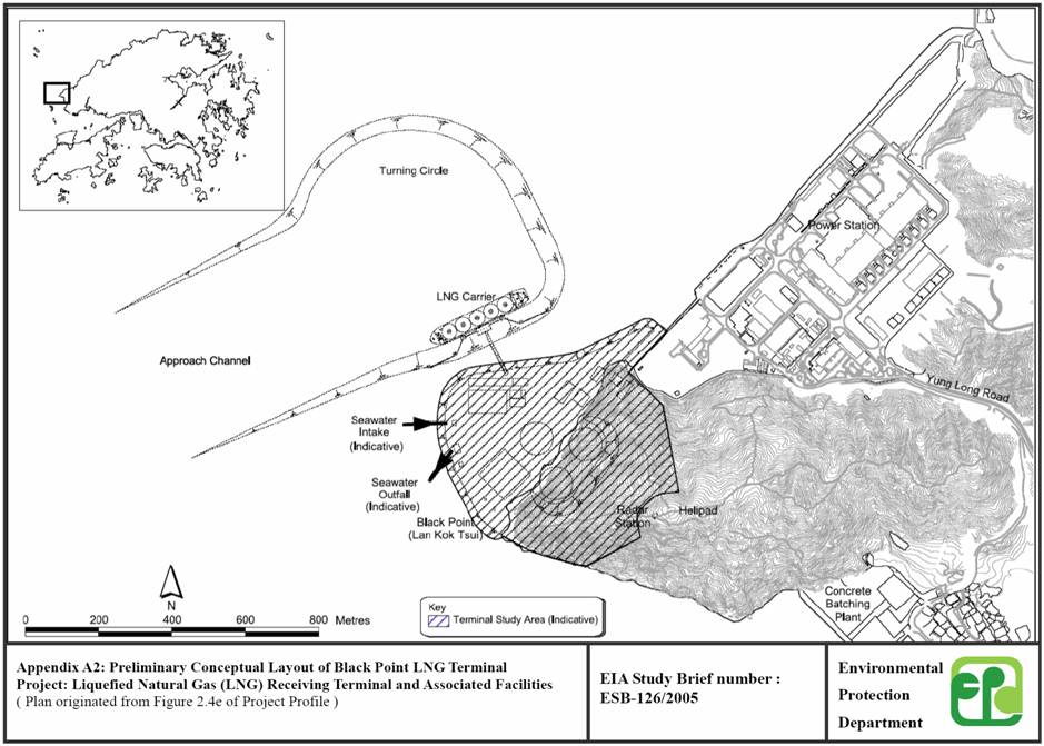
The proposed Project is to develop a
Liquefied Natural Gas Terminal (LNG) in the Hong Kong SAR. This will involve the construction and
operation of a LNG receiving terminal and its associated facilities at either
the
1.3
The scope of the Project includes
the followings:
Approximately
30 ha of land are required to install the necessary infrastructure of the
receiving terminal, which would include at least the following facilities:
Ÿ
Jetty and unloading
arms
Ÿ
Process Area
Ÿ
Up to 3 LNG Tanks
Ÿ
Low Pressure and High
Pressure pumping systems
Ÿ
Vaporizers
(Regasification Area)
Ÿ
Vent or flare systems
(low pressure and high pressure)
Ÿ
Maintenance Workshop
Ÿ
Ÿ
Guard House
Ÿ
Utility Area
Ÿ
Control Room
Ÿ
Gas Metering Station
Ÿ
Emergency gas turbine
power generator (for the South Soko Island Option only)
Ÿ
Offshore Pipeline
launching area (for
Ÿ
Gas pipeline (for
Ÿ
Gas Receiving Station
at Blackpoint (for
Ÿ
Submarine Power Cable
(for
Ÿ
Potential Submarine
Water Main (for
Gas
will be piped to the Black Point Power Station (BPPS) via a short onshore pipeline for the Black Point Option or via an
approximately 40 km long
submarine
gas pipeline for the South Soko Option.
Presently, a typical LNG
carrier measures approximately 285 m long, 43 m wide and 12 m draft, and is
able to transport around 145,000 m3 of LNG. LNG carriers
of larger sizes, up to 215,000 m3, may be considered by the Applicant.
Maintenance dredging may be required during the
operational phase since the berthing area, the approach channel and the turning
circle will be subject to natural siltation.
1.4 The
following elements of the Project addressed in this Project Profile are
classified as Designated Projects under the Environmental
Impact Assessment Ordinance (Cap. 499) (EIAO).
For both the
Ÿ
A
storage, transfer and trans-shipment of liquefied natural gas with a storage
capacity of not less than 200 tonnes (item L.2
of Part I of Schedule 2 of EIAO);
Ÿ
Dredging
operation for the approach channel and turning circle that exceeds 500,000 m3 (item C.12 of Part
I of Schedule 2 of EIAO).
For the South Soko Island option only:
Ÿ
Installation
of a submarine gas pipeline connecting the proposed LNG terminal at the South
Soko Island and the Black Point Power Station (item H.2 of Part I of Schedule 2 of EIAO);
Ÿ
Dredging
operation for the installation of a submarine power cable connecting Shek Pik
with the proposed LNG terminal at South Soko which is less than 500m from the
nearest boundary of an existing Site of Cultural Heritage (item C.12(a) of Part I of Schedule 2 of EIAO);
and,
Ÿ
Potential
dredging operation for the installation of a submarine water main connecting
Shek Pik with the proposed LNG terminal at South Soko which is less than 500m
from the nearest boundary of an existing Site of Cultural Heritage (item C.12(a) of Part I of Schedule 2 of EIAO).
For the Black Point
option only:
Ÿ Reclamation works (including associated dredging works)
of more than 5 ha in size (item C.1 of Part
I of Schedule 2 of EIAO).
1.5
Pursuant to section 5(7)(a) of the
EIAO, the Director of Environmental Protection (the Director) issues this EIA
study brief to the Applicant to carry out an EIA study.
1.6
The
purpose of this EIA study is to provide information on the nature and extent of
environmental impacts arising from the construction and operation of the
Project and related activities that take place concurrently. This information
will contribute to decisions by the Director on:
(i) the overall acceptability of any
adverse environmental consequences that is to arise as a result of the Project
and the associated activities of the Project;
(ii)
the
conditions and requirements for the detailed design, construction and operation of the Project to mitigate
against adverse environmental consequences; and
(iii) the acceptability of residual
impacts after the proposed mitigation measures are implemented.
2. OBJECTIVES
OF THE EIA STUDY
2.1 The
objectives of the EIA study are as follows:
(i)
to describe the Project and
associated works together with the requirements for carrying out the Project;
(ii)
to provide information on the intended
uses of the LNG and justify the proposed capacity of the facilities;
(iii)
to identify the types of Designated
Projects under Part I Schedule 2 of the EIAO to be covered in the Project;
(iv)
to identify and describe the
elements of the community and environment to be affected by the Project, including
any loss of natural coastline, rocky or sandy shore, the population close to
the LNG carrier route, and/or to cause adverse impacts to the Project,
including both the natural and man-made environment and the associated
environmental constraints;
(v)
to consider alternatives including,
but not limited to, location, size of reclamation, scale of development, design
layout, with a view to avoiding and minimizing the potential environmental
impacts on marine waters and the ecological sensitivity areas and other
sensitive uses; to compare the environmental benefits and dis-benefits of each of
the different options; to provide reasons for selecting the preferred option(s)
and to describe the part of environmental factors played in the selection;
(vi)
to identify and quantify emission
sources and determine the significance of impacts on sensitive receivers and
potential affected uses;
(vii) to identify and quantify any
potential losses or damage to flora, fauna and natural habitats and to propose measures
to mitigate these impacts;
(viii) to identify any negative impacts on
Chinese White Dolphin and Finless porpoise and to propose measures to mitigate
these impacts;
(ix)
to identify any negative impacts on
fisheries and to propose measures to mitigate these impacts;
(x)
to identify any potential landscape
and visual impacts and to propose measures to mitigate these impacts;
(xi)
to identify the risk due to the
transportation and storage of LNG and to propose measures to mitigate the
impact;
(xii) to
identify the risk to environmental sensitive receivers, including the
marine and terrestrial habitats, due to LNG leakage and the consequential fire hazard and to propose measures to minimize the potential risk;
(xiii) to identify any negative impacts on
sites of cultural heritage and to propose measures to mitigate these impacts;
(xiv)
to compare the environmental merits and demerits of the
Soko and/or Black Point Option with other options;
(xv) to propose the provision of mitigation
measures to minimize pollution, environmental disturbance and nuisance during
construction and operation of the Project;
(xvi) to investigate the feasibility,
practicability, effectiveness and implications of the proposed mitigation
measures;
(xvii) to identify, predict and evaluate
the residual environmental impacts (i.e. after practicable mitigation) and the
cumulative effects expected to arise during the construction and operation
phases of the Project in relation to the sensitive receivers and potential affected
uses;
(xviii) to
identify, assess and specify methods, measures and standards, to be included in
the detailed design, construction and operation of the Project which are
necessary to mitigate these risks, environmental impacts and cumulative effects
and reduce them to acceptable levels;
(xix) to investigate the extent of the
secondary environmental impacts that may arise from the proposed mitigation
measures and to identify constraints associated with the mitigation measures
recommended in the EIA study, as well as the provision of any necessary
modification; and
(xx) to design and specify the environmental
monitoring and audit requirements to ensure the effective implementation of the
recommended environmental protection and pollution control measures.
3. DETAILED
REQUIREMENTS OF THE EIA STUDY
3.1 The Purpose
The
purpose of this study brief is to scope the key issues of the EIA study and to
specify the environmental issues that are required to be reviewed and assessed
in the EIA report. The Applicant
shall refer to Section 3.2 �V Section 3.4 for the South Soko Option, and Section
3.5 �V Section 3.7 for the Blackpoint Option. The Applicant has to demonstrate
in the EIA report that the criteria in the relevant sections of the Technical
Memorandum on the Environmental Impact Assessment Process of the Environmental
Impact Assessment Ordinance (hereinafter referred to as ��the TM��) are met.
3.2 The
Scope for the
The scope for the South Soko Option of
this EIA study shall cover the Project scope for the South Soko Option as
proposed in the Project Profile and shall include the relevant works and
facilities mentioned in Section 1.3 above.
The Applicant shall review and consider the previous relevant planning
studies, including the South West New Territories
Development Strategy Review (SWNT DSR), and identified issues, public opinion
and study findings as being of relevance to the project. The EIA study shall
address the key issues described below, together with any other key issues
identified during the course of the EIA study and the cumulative environmental
impacts of the Project, through interaction or in combination with other
existing, committed, planned and known potential developments, including the
proposed Marine Park surrounding Soko Islands and the planned Spa and Resort
Development at Tai A Chau in the vicinity of the Project:
(i)
the potential water quality impact caused by
dredging, reclamation, pipeline laying and any other marine works activities
during construction and the discharges during operation, in particular the
potential impacts to the ecological resources due to increases in suspended
sediment concentrations and potential decrease in dissolved oxygen; and the
release of cooled water during operation.
(ii)
the potential impact to the ecological
sensitive areas, including the vicinities along the marine portion of the
Project which are frequented by the Chinese White Dolphins and Finless
Porpoise;
(iii)
The potential ecological impacts arising from
the construction and operation of the Project, including loss of habitats,
disturbance to wildlife and pollution, if any, caused by run-off;
(iv)
The potential fisheries impacts during the
construction and operation of the Project, including the potential loss of
fishing grounds, spawning and nursery grounds of fish and shrimp;
(v)
The potential noise and air pollution impacts
to sensitive receivers during the construction and operation of the Project;
(vi)
The potential landscape and visual impacts
caused by reclamation, LNG Terminal and associated facilities, including
storage tanks, infrastructures, structures, LNG carriers and associated works
on existing and planned sensitive receivers, during the construction and
operation of the Project;
(vii) The potential glare impacts on the nearby
sensitive receivers during operation of the Project;
(viii) The potential impacts of various types of
wastes to be generated from the construction and operation of the Project, in
particular the dredged sediment during reclamation;
(ix)
The potential waste
management issue associated with the use of filling materials such as marine
sand and inert construction and demolition material (C&DM) for reclamation
during construction of the Project;
(x)
The potential hazard to life on the general
public and the workers of the Project due to the LNG storage, transfer and the
marine transportation within HKSAR;
(xi)
The potential cumulative environmental impacts
of the Project, through interaction or in combination with other existing,
committed and planned developments in the vicinity of the Project, and those
impacts may have a bearing on the environmental acceptability of the Project.
Consideration shall be given to account for the impacts from likely concurrent
projects;
(xii) The potential impact on site of cultural
heritage during the construction of the Project.
3.3 Consideration of Alternative Location,
Layout and Construction Methods for the
3.3.1 Need for the Project
The
Applicant shall present in the EIA the information on the need for the Project
and the Project��s implementation programme.
3.3.2 Consideration of different
options on LNG provision
The EIA study shall take into consideration with clear
and objective comparison of the environmental benefits and disbenefits of the
different options for the provision of LNG to HKSAR
and also with or without the proposed developments. The
options to be considered should include the proposed LNG terminal and gas
pipeline option linking to other possible LNG sources.
3.3.3 Consideration of different
site locations
The EIA study shall take into
consideration with clear and objective comparison of the environmental benefits
and disbenefits of different site location. The applicant shall compare the
main environmental impacts and provide reasons for selecting the proposed site
locations and the part environmental factors played in the selection shall be
described. This is particularly
relevant to the size and location of the facility, the size of reclamations,
the extent of dredging for the navigation channel, the extent of natural slope
cutting, submarine pipeline alignment, submarine power cable, submarine water
main, construction method, number and size of the fuel tanks and piers. In formulating the preferred options, the
Applicant shall seek to avoid adverse environmental effects to the maximum
practicable extent.
3.3.4 Consideration of Different
Layouts and Design Options
The Applicant shall present in the EIA
report the considerations of alternative reclamation layouts and internal
layout and design (such as location of various infrastructures and facilities)
of the facilities, including alignment/option to the submarine natural gas
pipeline, submarine power cable, submarine water main, the size and
configuration of the approach channel and turning circle, with regard to
avoiding or minimising the associated environmental impacts. In addition, the applicant shall
consider adopting a design to avoid the sensitive environment between Tai A
Chau and Siu A Chau, ie, a shorter channel or approach from the western side,
etc.
The
Applicant shall present information on the requirement on the size of the
terminal in relation to the number of tankers per unit time, with regard to optimise
the size of the facility.
3.3.5 Consideration of
Alternative Construction Methods and Sequence of Works
Having
regard to the cumulative effects of the construction period and the severity of
the construction impacts to the affected sensitive receivers, the EIA study
shall explore alternative construction methods and sequences of works for the
Project, with a view to avoiding adverse environmental impacts to the maximum
practicable extent. A comparison of the environmental benefits and dis-benefits
of applying different construction methods and sequence of works shall be made
with a view to recommending the preferred option to avoid adverse on-site and
off-site environmental impact to the maximum practicable extent.
3.3.6 Consideration of Pipeline
Construction Method and Alignment
The EIA shall explore different pipeline
construction method, including underground pipeline option. If the submarine pipeline option is
selected, the Applicant shall consider alternative submarine pipeline alignment
to avoid or minimize any potential impacts to the ecologically valuable
habitats, including Sha Chau and
3.3.7 Selection of Preferred
Scenario
Taking
into consideration of the findings in Sections 3.3.2 to 3.3.6 above, the
Applicant shall provide justifications and recommend the preferred reclamation
layout and method and the internal layout and design of the facility that will
avoid or minimize adverse environmental effects arising from the Project and
shall adequately describe the part that environmental factors played in
arriving at the final selection.
3.4 Technical Requirements for the
The
Applicant shall conduct the EIA study to address the environmental aspects as
described in Sections 3.1, 3.2 and 3.3 above. The assessment shall be based on
the best and latest information available during the course of the EIA study.
The Applicant shall assess the cumulative environmental impacts from the
Project with other interacting projects. The Applicant shall include in the EIA
report details of the construction programme and methodologies.
3.4.1 Air Quality Impact
3.4.1.1 The Applicant shall follow the criteria and guidelines as stated in
Section 1 of Annex 4 and Annex 12 of the TM for evaluating and assessing the air
quality impact due to the construction and operation of the Project, as
stipulated in Sections 1.2 and 1.3 above.
3.4.1.2 The study area for air quality impact assessment shall generally be
defined by a distance of 500 metres from the boundary of the project site, and
it shall be extended to include major emission sources such as power station
and large industrial establishment that may have a bearing on the environmental
acceptability of the Project. For this Project, the assessment shall include
the existing and planned/ committed air sensitive receivers within the study
area as well as areas where the air quality may be potentially affected by the
Project. Such assessment shall be based on the best available information at the
time of the assessment.
3.4.1.3 The air quality impact assessment shall include the following:
(i) Background and Analysis of Activities
(a)
Provide
background information relating to air quality issues relevant to the Project,
e.g. description of the types of activities of the Project that may affect air
quality during both construction and operation stages.
(b)
Present
background air quality levels in the assessment area for the purpose of
evaluating cumulative constructional and operational air quality impacts.
(c)
Consider
alternative construction methods/phasing programmes and alternative modes of
operation to minimize the constructional and operational air quality impact;
(d)
Consider
the potential leakage of LNG into the atmosphere identified in Section 3.7.9.1(v)
during the operation of the project.
(ii) Identification of Air Sensitive Receivers (ASRs)
and Examination of Emission/ Dispersion Characteristics
(a) Identify and describe existing and planned/committed
ASRs that would be affected by the Project, including those indicated on the
relevant Outline Zoning Plans, Development Permission Area Plans, Outline
Development Plans and Layout Plans. The Applicant shall select the assessment
points of the identified ASRs that represent the worst impact point of these
ASRs. A map showing the location and description such as name of buildings,
their uses and height of the selected assessment points shall be
given. The separation distances of these ASRs from the nearest emission sources
shall also be given. For phased development, the Applicant shall review the
development programme against the different construction stages to assess
whether the occupiers of the early phases could become ASRs to be affected by
the construction works of later phases.
(b) Provide an exhaustive list of air pollutant
emission sources, which are to have impact related to the Project based on the
analysis of constructional and operational activities in Section 3.4.1.3(i)
above. Besides, if the likely
concurrent projects are identified relevant, its possible emissions shall also
be taken into account in the air quality impact assessment. Examples of
construction stage emission sources include stockpiling, blasting, concrete
batching, marine construction plant and vehicular movements on unpaved haul
roads on site. Confirmation of validity of the assumptions and magnitude of the
activities (e.g. volume of construction material handled) shall be obtained
from the relevant government departments/authorities and documented.
(iii) Construction Phase Air Quality Impact
(a)
The
Applicant shall follow the requirements stipulated under the Air Pollution
Control (Construction Dust) Regulation to ensure that construction dust which
may arise as a result of the works are controlled within the
relevant standards as stipulated in Section 1 of Annex 4 of the TM. A monitoring and audit programme for the
construction phase shall be devised to verify the effectiveness of the control
measures.
(b)
If
the Applicant anticipates that the Project will give rise to significant
construction dust impacts likely to exceed recommended limits in the TM at the
ASRs despite the incorporation of the dust control measures proposed in
accordance with Section 3.4.1.3(iii)(a) above, a quantitative assessment should
be carried out to evaluate the construction dust impact at the identified
ASRs. The Applicant shall follow
the methodology set out in Section 3.4.1.3(v) below when carrying out the
quantitative assessment.
(iv) Operational Phase Air Quality Impact
The
Applicant shall calculate
the expected air pollutant concentrations, such as odour, gaseous emission and
dust, at the identified ASRs based on an assumed reasonably worst-case
scenario. The evaluation shall be
based on the strength of the emission sources identified in Section
3.4.1.3(ii)(b) above. The Applicant shall follow Section 3.4.1.3(v) below when
carrying out the quantitative assessment.
(v) Quantitative
Assessment Methodology
(a) The Applicant shall apply the general principles
enunciated in the modelling guidelines in Appendices B-1 to B-3 while making
allowance for the specific characteristics of the Project. This specific methodology must be
documented in such level of details (preferably with tables and diagrams) to
allow the readers of the assessment report to grasp how the model is set up to
simulate the situation at hand without referring to the model input files. Details of the calculation of the
emission rates of air pollutants for input to the modelling shall be presented
in the report. The Applicant must
ensure consistency between the text description and the model files. In case of doubt, prior agreement between
the Applicant and the Director on the specific modelling details should be
sought.
(b) The Applicant shall identify the key/representative
air pollutant parameters (types of pollutants and the averaging time
concentration) to be evaluated and provide explanation for choosing these
parameters for the assessment of the impact of the Project.
(c)
The
Applicant shall calculate the overall cumulative air quality impact at the
identified ASRs identified under Section 3.4.1.3(ii) above and compare these
results against the criteria set out in Section 1 of Annex 4 in the TM. The predicted air quality impacts (both
unmitigated and mitigated) shall be presented in the form of summary table and
pollution contours, to be evaluated against the relevant air quality standards
and on any effect they may have on the land use implications. Plans of a suitable scale should be used
to present pollution contour to allow buffer distance requirements to be
determined properly.
(vi) Mitigation Measures for Non-compliance
The Applicant shall propose
remedies and mitigating measures where the predicted air quality impact exceeds
the criteria set in Section 1 of Annex 4 in the TM. If these measures will result in any
constraints on future land use planning outside the project site, the Applicant
shall liaise with the relevant government departments/authorities and document
the agreement in the EIA Report in order to demonstrate that the proposed
measures are feasible and practicable.
The Applicant shall demonstrate quantitatively that the residual impacts
after incorporation of the proposed mitigating measures will comply with the
criteria stipulated in Section 1 of Annex 4 in the TM.
(vii) Submission of Model Files
Input and output file(s) of
the model run(s) shall be submitted to the Director in electronic format.
3.4.2
Noise
Impact
3.4.2.1
The
Applicant shall follow the criteria and guidelines for evaluating and assessing
noise impact as stated in Annexes 5 and 13 of the TM respectively.
3.4.2.2
The
noise impact assessment shall include the following:
(i) Determination of Assessment Area
The noise impact assessment
shall include all areas within 300m from the project boundary. Subject to the agreement of the Director,
the assessment area could be reduced accordingly if the first layer of noise
sensitive receivers, closer than 300m from the project boundary, provides
acoustic shielding to those receivers located further away. Similarly, subject to the agreement
of the Director, the assessment area shall be expanded to include NSRs at
distance greater than 300m from the boundaries of proposed developments which
are noise sensitive if they may be affected by the construction and operation
of the proposed developments.
(ii) Provision of Background Information
The Applicant shall provide
all background information relevant to the project including relevant previous
and current studies. Unless involved in the planning standards, no existing
noise levels are particularly required.
(iii) Identification of Noise
Sensitive Receivers
(a)
The
Applicant shall refer to Annex 13 of the TM when identifying the noise
sensitive receivers (NSRs). The NSRs shall include all existing ones and all
planned or committed noise sensitive developments and uses earmarked on the
relevant Outline Zoning Plans, Outline Development Plans, Layout Plans and
other relevant published land use plans.
(b) A map showing the location and description such as name of
building, use, and floor of each and every selected assessment point shall be
given. For planned noise sensitive land uses without committed site
layouts, the Applicant should use the relevant planning parameters to work out
representative site layouts for operational noise assessment purpose.
(iv) Provision of an Emission
Inventory of the Noise Sources
The Applicant shall provide
an inventory of noise sources including construction equipment for construction
noise assessment; fixed plant equipment for operational noise assessment.
Confirmation of the validity of the inventory shall be obtained from the
relevant government departments/authorities and documented.
(v) Construction Noise
Assessment
(a)
The
Applicant shall carry out assessment of noise impact from construction
(excluding percussive piling) of the project during day time, i.e. 7 a.m. to 7
p.m., on weekdays other than general holidays in accordance with the
methodology stipulated in paragraphs 5.3. and 5.4 of Annex 13 of the TM. The criteria in Table 1B of Annex 5 of
the TM shall be adopted in the assessment.
(b)
To
minimize the construction noise impact, alternative construction methods to
replace percussive piling shall be proposed as far as practicable. In case
blasting works will be involved, it should be carried out, as far as
practicable, outside the sensitive hours of 7 p.m. to 7 a.m. on Monday to
Saturday and any time on a general holiday, including Sunday. For
blasting that must be carried out during the above-mentioned sensitive hours,
the noise impact associated with the removal of debris and rocks should be
fully assessed and adequate mitigation measures should be recommended to reduce
the noise impact as appropriate.
(c)
If
the unmitigated construction noise levels are found to exceed the relevant
criteria, the Applicant shall propose practicable direct mitigation measures (including
movable barriers, enclosures, quieter alternative methods, re-scheduling and
restricting hours of operation of noisy tasks) to minimize the impact. If the mitigated noise levels still
exceed the relevant criteria, the duration of the noise exceedance shall be
given.
(d)
The
Applicant shall formulate a reasonable construction programme as far as
practicable such that no work will be required in the restricted hours as
defined under the Noise Control Ordinance (NCO). In case the Applicant
needs to evaluate whether construction works in restricted hours as defined
under the NCO are feasible or not in the context of programming construction
works, reference should be made to the relevant technical memoranda issued
under the NCO. Regardless of the results of the construction noise impact
assessment for restricted hours, the Noise Control Authority will process the
Construction Noise Permit (CNP) application, if necessary, based on the NCO,
the relevant technical memoranda issued under the NCO, and the contemporary
conditions/situations. This aspect should be explicitly stated in the
noise chapter and the conclusions and recommendations chapter in the EIA report.
(vi) Operational Noise Impact Assessment
(a)
The Applicant shall
analyze the scope of the proposed system to identify noise sources for the
purpose of noise impact assessment.
(b) The
Applicant shall calculate the expected noise using standard acoustic
principles. Calculations for the expected noise shall be based on assumed
plant inventories and utilization schedule for the worst case scenario.
The Applicant shall calculate the noise levels taking into account of
correction of tonality, impulsiveness and intermittency in accordance with the
Technical Memorandum for the Assessment of Noise from Places other than
Domestic Premises, Public Places or Construction Sites.
(c) The Applicant shall present the
relevant noise levels in Leq (30 mins) at the NSRs at various representative
floor levels (in mPD) in tables and plans of suitable scales. Quantitative
assessment at the NSRs for proposed fixed noise source(s) shall be carried out
and compared against the criteria set out in Table 1A of Annex 5 of the TM.
(d) Proposals for Noise
Mitigation Measures: (i) The Applicant shall propose direct technical remedies
in all situations where the predicted noise level exceeds the criteria set out
in Table 1A of Annex 5 of the TM to protect the affected NSRs. Specific
reasons for not adopting certain direct technical remedies in the design to
reduce the noise to a level meeting the criteria in the TM or to maximize the
protection for the NSRs should be clearly quantified and laid down. The total
number of dwellings and other noise sensitive element that will be benefited by
the provision of direct technical remedies should be provided; (ii) The total
number of dwellings and other noise sensitive elements that will still be
exposed to noise above the criteria with the implementation of all recommended
direct technical remedies shall be quantified.
(vii) Assessment
of Side Effects and Constraints
The Applicant shall identify, assess and
propose means to minimize any side effects and to resolve any potential constraints
due to the inclusion of any recommended direct technical remedies.
(viii) Evaluation of Constraints on Planned
Noise Sensitive Developments/Land Uses
For
planned noise sensitive uses which will still be affected even with all
practicable direct technical remedies in place, the Applicant shall propose,
evaluate and confirm the practicality of additional measures within the planned
noise sensitive uses and shall make recommendations on how these noise
sensitive uses will be designed for the information of relevant parties.
The Applicant
shall take into account the agreed environmental requirements/constraints
identified by the study to assess the development potential of the concerned
sites which shall be made known to the relevant parties.
3.4.3 Water
Quality Impact
3.4.3.1 The Applicant shall follow the criteria and
guidelines for evaluating and assessing water pollution
as stated in Annexes 6 and 14 of the TM respectively.
3.4.3.2 The study area for the purpose of water quality
impact assessment shall cover the Southern, Southern Supplementary, Second
Southern Supplementary, North Western, North Western Supplementary, Deep Bay
Water Control Zones as designated under the Water Pollution Control Ordinance
(Cap. 358, WPCO). This study area could be extended to cover other areas such
as stream courses and the associated water system, existing and new drainage
system, wetland, estuaries, coastal, marine and fresh water, groundwater
system; and the associated catchment area(s) being impacted and to be
identified during the course of the EIA study.
3.4.3.3 The Applicant shall identify and analyse all
physical, chemical and biological disruptions
of marine, estuarine, fresh water, ground water system(s) and the associated
catchment area(s) arising during the construction and operation of the
Project.
3.4.3.4 The water
quality impact assessment shall cover the following, but not limited to, major
areas of concern :
(i)
Construction
and operational impacts arising from the reclamation and berthing facilities
being proposed;
(ii)
Dredging
of marine sediment for the construction and maintenance of navigation channel,
turning circle and berthing area;
(iii)
Impacts
arising from the laying, submarine trenching (such as, but not limited to, by
means of dredging, ploughing and jetting), testing and commissioning, operation
and maintenance of submarine gas pipeline;
(iv)
Construction
impacts of any proposed water mains and power cable;
(v)
Impacts
of thermal and chemical discharge due to treatment and disposal of spent cooled
water from regasification facility;
(vi)
Impacts
of potential on-site sewage treatment and disposal facilities;
(vii)
Impacts
of potential spillage of fuel and LNG and treatment and disposal of ballast
water during operational phase of the Project and transportation of LNG
carrier.
3.4.3.5 Essentially the assessment shall address the
following :
(i) Collection
and review of background information on the existing water system(s) and the
respective catchment(s).
(ii)
Characterization of
water and sediment quality based on existing information or site surveys/tests
as appropriate.
(iii) Identification
and analysis of all existing and planned future activities and beneficial uses
related to the water system(s) and identification of all water sensitive
receivers.
(iv) Establishment
of pertinent water and sediment quality objectives, criteria and standards for
the water system(s) and all the sensitive receivers.
(v)
Identification of any
alteration of water courses, natural streams/ponds, wetland, change of
shoreline or bathometry, change of flow regimes, change of ground water levels,
change of catchment types or areas.
(vi)
Review the specific
construction methods and configurations of the Project, such as, but are not
limited to, the reclamation sides and configuration, design and configurations
of the berthing facilities; the submarine gas pipeline alignment and its laying
and submarine trenching method.
(vii) Identification,
analysis and quantification of all existing and likely future water and
sediment pollution sources, including point discharges and non-point sources to
surface water runoff, sewage, spent industrial wastewater from the Project such
as, but are not limited to, cooled water, spent hydrostatic testing effluent
and ballast water. Field investigation and laboratory tests shall be conducted
as appropriate. Establishment and
provision of an emission inventory on the quantities and characteristics of all
these pollution sources.
Impact Prediction
(viii) Prediction
and quantification, by mathematical modelling or other technique to be approved
by EPD, of the impacts on the water system(s) and the sensitive receivers due
to the construction and operation of the Project. The mathematical modeling requirements
are set out in Appendix C of this Study Brief. Possible impacts include change in
hydrology, flow regime, sediment erosion or deposition, water and sediment
quality and the effects on the aquatic organism due to such changes in the
affected water bodies. The
prediction shall take into account and include possible different construction
stages or sequences, and different operation stages. For the assessment of potential spillage
of fuel and LNG, potential locations, quantities and rates of spillage should
be identified and quantified. The spillage modeling assessment should cover
combination of different tides, wind and season conditions. Affected sensitive receivers should be
identified by the assessment tool with indication of degree of severity.
(ix)
Assessment of the
cumulative impacts due to other related concurrent and planned projects,
activities or pollution sources within a boundary around the study area to be
agreed by the Director, that may have a bearing on the environmental
acceptability of the Project through mathematical modelling. This shall include
the potential cumulative construction and operational water quality impacts
arising from, inter alia, the associated works of the Project, the activities
and planned projects to be approved by the Director when the programme of the
Project and associated works is confirmed during the course of the EIA study.
Wastewater and
(x) Assessment
and quantification on the adequacy of existing and future sewerage
infrastructure to treat and dispose of the wastewater identified above. In general all waste water generated
shall have to meet effluent discharge standards set out in the Technical
Memorandum stipulated under the WPCO prior to discharge.
(xi) Assessment
and quantification of all existing and future water pollutants from non-point
sources and analysis on the provision and adequacy of existing and future
facilities to reduce such pollution.
Dredging, Submarine Trenching Works, Filling and
Dumping
(xii) Identification
and quantification of all dredging, submarine trenching, fill extraction, back
filling, reclamation, mud/sediment transportation and disposal activities and
requirements. Potential fill source and dumping ground to be involved shall
also be identified. Field
investigation, sampling and laboratory tests to characterize the sediment/mud
concerned shall be conducted as appropriate. The potential for the release of
contaminants during dredging shall be addressed using the chemical testing
results derived from sediment and marine water samples collected on site and
relevant historic data. Appropriate
laboratory tests such as elutriate tests in accordance with the USACE method
and sediment pore water (interstitial water) analyses shall be performed on the
sediment samples to simulate and quantify the degree of mobilization of various
contaminants such as metals, ammonia, nutrients, trace organic contaminants
(including PCBs, PAHs, TBT and chlorinated pesticides) into the water column
during dredging. The ranges of parameters to be analyzed; the number, location,
depth of sediment, type and methods of sampling; sample preservation; and
chemical laboratory test methods to be used shall be subject to the approval of
the Director. The Applicant shall also address the pattern of the sediment
deposition and the potential increase in turbidity and suspended solid levels
in the water column and at the sensitive receivers due to the disturbance of
sediments during dredging and back filling, dumping and submarine trenching.
(xiii) Prediction,
quantification and assessment of impacts on the hydrodynamic regime, water and
sediment quality of the water system(s) and the sensitive receivers due to the
activities identified above. The prediction and quantification of impacts
caused by, amongst others, sediment re-suspension and contaminants release
shall be carried out by mathematical modeling (see modeling requirements set
out in Appendix C of this Study Brief) or other techniques to be approved by
the Director.
(xiv) Recommendation
of appropriate mitigation measures to avoid or minimize the impacts identified
above, in particular suitable mud dredging and disposal, submarine trenching
and backfilling method(s). The
residual impacts on the water system(s) and the sensitive receivers with regard
to the relevant water and sediment quality objective, criteria, standards or
guidelines shall be assessed and quantified by mathematical modeling as set out
in Appendix C in this Study Brief or other techniques to be approved by the
Director.
(xv) Identification
and evaluation of the best practicable dredging, submarine trenching,
backfilling, marine mud disposal and reclamation methods to minimize marine mud
disturbance and dumping requirements and demand for fill sources based on the
criterion that existing marine mud shall be left in place and not be disturbed
as far as possible.
(xvi) Prediction and quantification of cumulative impacts
due to other dredging, filling or dumping activities within a boundary around
the Study Area to be agreed by the Director shall also be predicted and
quantified.
Mitigation
(xvii) Proposal
of effective infrastructure upgrading or provision, water pollution prevention
and mitigation measures to be implemented during the construction and
operational stages so as to avoid and reduce the water and sediment quality
impacts to within acceptable levels of standards. Requirements to be incorporated in the
Project contract document shall also be proposed.
(xviii) Best
management practices to reduce storm water and non-point source pollution shall
be investigated and proposed as appropriate. Attention shall be made to the
water quality control and mitigation measures recommended in the Practice Note
for Authorized Persons and Registered Structural Engineers on construction site
drainage.
(xix) Evaluation
and quantification of residual impacts on the water system(s) and the sensitive
receivers with regard to the appropriate water and sediment quality objectives,
criteria, standards or guidelines using appropriate mathematical models as set
out in Appendix C in this Study Brief or other techniques approved by the
Director.
3.4.4
Waste Management Implications
3.4.4.1
The Applicant shall follow the criteria and guidelines for
evaluating and assessing waste management implications as stated in Annexes 7
and 15 of the TM.
3.4.4.2
The assessment of waste management implications shall cover the
following:
(i) Analysis
of Activities and Waste Generation
The
Applicant shall identify the quantity, quality and timing of the waste and
chemical waste arising as a result of the construction and operation activities
of the Project, based on the sequence and duration of these activities. The
Applicant shall adopt the design, general layout, construction methods and
programme that will maximise the use of public fill/inert C&DM for the
reclamation works.
(ii) Proposal
for Waste Management
(a) Prior to considering the disposal options for
various types of wastes, opportunities for reducing waste generation, on-site
or off-site re-use and recycling shall be evaluated. Measures that can be taken in the
planning and design stages e.g. by modifying the design approach and in the construction
stage for maximizing waste reduction shall be separately considered.
(b) After considering the opportunities for
reducing waste generation and maximizing re-use, the types and quantities of
the wastes required to be disposed of as a consequence shall be estimated and
the disposal options for the wastes shall be described in detail. The disposal
options recommended for each type of wastes shall take into account the result
of the assessment in item (c) below.
The EIA report shall also state clearly the transportation routings and
the frequency of the trucks/ vessels involved, any barging point or conveyor
system to be used, the stockpiling areas and the disposal outlets for the
wastes identified; and
(c) The impact caused by handling (including stockpiling,
labelling, packaging & storage), collection, transportation and disposal of
wastes shall be addressed in detail and appropriate mitigation measures shall
be proposed. This assessment shall cover the following areas :
- potential
hazard;
- air
and odour emissions;
- noise;
- wastewater
discharge;
-
public transport; and
-
landscape and visual
impacts, if any.
(iii) Dredging, Filling and Dumping
(a)
The categories of
sediments which are to be disposed of in accordance with a permit under the Dumping
at Sea Ordinance (DASO) shall be identified by both chemical and biological
tests and their quantities shall be estimated. If the presence of any seriously
contaminated sediment which requires Type 3 disposal is confirmed, the
Applicant shall identify the most appropriate treatment and/or disposal
arrangement and demonstrate its feasibility;
(b)
Identification and
evaluation of the best practicable construction methods, treatment methods,
in-situ/ex-situ arrangements, reuse/ recycling options and construction
programme to minimize dredging and dumping requirements and demand for fill
sources based on the criterion that existing marine mud shall be left in place
and not to be disturbed as far as possible and the inert C&DM shall be used
to maximum practicable extent for reclamation works.
3.4.5 Ecological Impact (Both Terrestrial and
Aquatic)
3.4.5.1
The Applicant shall
follow the criteria and guidelines for evaluating and assessing ecological
impact as stated in Annexes 8 and 16 of the TM respectively.
3.4.5.2
The study area for the
purpose of terrestrial ecological assessment shall include all areas within 500
metres from the site boundary of the land based works areas or the area likely
to be impacted by the Project. For
aquatic ecology, the study area shall be the same as the water quality impact
assessment as stipulated in 3.4.3.2 or the area likely to be impacted by the Project.
3.4.5.3
In
the ecological impact assessment, the Applicant shall examine the flora, fauna
and other components of the ecological habitats within the assessment area, including
those highlighted in sub-section 3.2 above. The aim shall be to protect, maintain or
rehabilitate the natural environment. In particular, the Project shall avoid
impacts on recognized sites of conservation importance and other ecological
sensitive areas. The assessment
shall identify and quantify as far as possible the potential ecological impacts
arising from the construction and operation of the Project and in combination
with those cumulative impacts from the associated works of the Project, both
directly by physical disturbance and indirectly by changes of water quality,
sedimentation patterns and hydrodynamic regime. Details of specific requirements on the
assessment of impacts on the Finless Porpoise and the Chinese White Dolphin are
stipulated in sub-section 3.4.5.5 below.
3.4.5.4 The assessment shall include the following
major tasks:
(i) review the findings of relevant previous studies/surveys and collate all available information on the ecological characters of the study area;
(ii) evaluate the information collected from sub-section 3.4.5.4 (i) above, and identify any information gap relating to the assessment of potential ecological impacts to the aquatic and terrestrial environment including the Sha Chau and Lung Kwu Chau Marine Park; the potential southwest Lantau Marine Park in Fan Lau fish spawning and nursery area in the southern waters including the fish fry area in Tai A Chau.
(iii) carry out necessary field surveys, including any advanced surveys commenced before this EIA, for a total duration of at least 6 months (which shall cover the wet season), and investigations to verify the information collected, fill the information gaps identified in sub-section 3.4.5.4 (ii) above and fulfill the objectives of the EIA study;
(iv) carry
out a boat survey of at least eight months covering the period from October to
May (both inclusive) for the Chinese White Dolphin and Finless Porpoise in
waters adjacent to Sokos area, the proposed submarine gas pipeline alignment,
the proposed submarine power cable and the potential submarine water main. The methodology of the boat survey shall
be consistent with the previous related studies, in particular the ��Population
Biology of the Indo-Pacific Hump-backed Dolphin in Hong Kong Waters�� (Wildlife
Monograph No. 144, page 1-65, published in October 2000).
(v) establish an ecological profile of the study area based on data of relevant previous studies/surveys and results of additional ecological field surveys, and describe the characteristics of each habitat found. Major information to be provided shall include:
(a) description
of the physical environment, including all recognized sites of conservation
importance and ecologically sensitive areas, and assess whether these sites
will be affected by the Project or not;
(b) habitats
maps of suitable scale showing the types and locations of habitats in the study
area;
(c) ecological
characteristics of each habitat type such as size, vegetation type, species
present, dominant species found, species diversity and abundance, community
structure, seasonal patterns, inter-dependence of the habitats and species, and
presence of any features of ecological importance;
(d) representative
colour photographs of each habitat type and any important ecological features
identified;
(e) species
found that are rare, endangered and/or listed under local legislation,
international conventions for conservation of wildlife/habitats or Red Data Books;
(f) investigate
and describe the existing wildlife uses of the various habitats with special
attention to those wildlife groups and habitats with conservation interests
(g) using suitable methodology to identify and quantify as far as possible any direct, indirect (e.g. changes in water qualities, hydrodynamics properties, sedimentation rates and patterns, hydrology), on-site, off-site, primary, secondary and cumulative ecological impacts on the wildlife groups and habitats mentions in sub-section 3.4.5.4 (v) above, such as destruction of habitats, reduction of species abundance/diversity, loss of feeding grounds, reduction of ecological carrying capacity, habitat fragmentation; and in particular the following:
-
habitat loss and
disturbance to wildlife during construction stage;
- potential
impacts on horseshoe crabs and their nursery areas;
- potential
impacts associated with reclamation, dredging, spoil disposal, extraction and
placement of fill materials during construction, and in particular to the
benthic communities;
- potential
impacts to the Chinese White Dolphin and Finless Porpoise including noise
disturbance, adverse effect caused by possible underwater blasting or
percussive pilling, possible contaminants from disturbed or dredged sediment,
and loss of habitat and food supply;
- potential
impacts to the fish spawning and nursery area in the southern waters including
the fish fry area in Tai A Chau
- deterioration
of environmental quality (e.g. water quality) and the subsequent impacts to the
biological communities during operation stage;;
- potential
impacts to the avifauna during operational stage due to the increase in noise,
air pollution, lighting, glare and physical barrier; and
- potential
loss and disturbance to natural shoreline, inter-tidal habitats and coral
communities during the construction and operation stages of the project.
(vi) demonstrate that the
ecological impacts due to the construction and operation of the Project are
avoided by design to the maximum practicable extent;
(vii) evaluate the significance and
acceptability of the ecological impacts identified using well-defined criteria;
(viii) recommend all possible
alternatives (such as different alignment, built-form and/or using other
construction methods and sequences) and practicable mitigation measures to
avoid, minimize and/or compensate for the adverse ecological impacts
identified, such as :
(a)
measures
to recreate the natural inter-tidal and sub-tidal habitats lost;
(b)
reinstatement
of habitats temporarily affected by the Project to its original state and if
possible with some enhancement features;
(ix)
evaluate
the feasibility and effectiveness of the recommended mitigation measures and
define the scope, type, location, implementation arrangement, subsequent
management and maintenance of such measures;
(x)
determine
and quantify as far as possible the residual ecological impacts after
implementation of the proposed mitigation measures;
(xi)
evaluate
the severity and acceptability of the residual ecological impacts using
well-defined criteria; and
(xii)
assess the risk
and the potential impact to environmental sensitive receivers, including the marine and
terrestrial habitats, due to LNG leakage and the consequential fire hazard. The assessment shall be based on the
possible leakage scenarios identified in 3.4.9, and also the water quality
assessment required in 3.4.3.4 (vii) and recommend any practicable measures to
reduce the risk to marine and terrestrial habitats;
(xiii) review the need for and
recommend any ecological monitoring programme required.
3.4.5.5 Impacts
on Finless Porpoise and Chinese White Dolphins
The
assessment of impacts on Finless Porpoise (Neophocaena
phocaenoides)and
Chinese White Dolphins (Sousa chinensis) shall include the following
tasks:
(i) review and incorporate the findings of
relevant studies including the previous Finless
Porpoise and dolphin
studies, in particular the ��Population Biology of the Indo-Pacific
Hump-backed Dolphin in Hong Kong Waters�� (Wildlife Monograph No. 144, page 1-65,
published in October 2000), and collate all available information regarding the
ecological characters of the study area;
(ii)
evaluate the information collected and identify any information gap
relating to the assessment of potential impacts on the Finless
Porpoise and Chinese
White Dolphins;
(iii)
as part of the requirement under sub-section 3.4.5.4 (iii) above, carry
out necessary field surveys and investigations to verify the information
collected, fill the information gaps identified, if any, and to fulfil the
objectives of the EIA study;
(iv)
present all relevant survey findings including
previous surveys conducted in relevant studies together with surveys carried
out under this study;
(v)
assess the direct and indirect
impacts, including water
quality changes, release of toxic contaminants from sediments and their
consequential ecological effects on the Finless
Porpoise and Chinese
White Dolphins, during the construction and operational stages of the Project. The assessment shall include:
(a) impacts and disturbance to
the Finless Porpoise and Chinese White Dolphins associated with reclamation,
dredging, fill extraction, filling, transportation and disposal of dredged
sediment;
(b) impacts on the Finless
Porpoise and Chinese White Dolphins of the possible use of underwater blasting
and underwater percussive pilling during construction stage, due to shock wave
and underwater noise generated;
(c) predicted water quality
changes and consequential ecological impacts on the Finless Porpoise and
Chinese White Dolphins. Parameters
to be assessed should include suspended solids, dissolved oxygen and
contaminants present in disturbed or dredged sediment. The significance and acceptability of
the predicted changes shall be evaluated using well-defined criteria;
(d) ecological impacts on the
Finless Porpoise and Chinese White Dolphins associated with potential bioaccumulation
of toxic contaminants released from the disturbed or dredged sediment. The significance and acceptability of
the predicted impacts shall be evaluated using well-defined criteria;
(e) potential risk on the Finless
Porpoise and Chinese White Dolphins colliding with marine vessels during
construction;
(f) change in marine
traffic volume, distribution and pattern during operational stage, and the
consequential increase or decrease in risk of Finless Porpoise and Chinese
White Dolphins colliding with marine vessels; and
(g) potential risk on the Finless
Porpoise and Chinese White Dolphins due to chemical spillages arising from
vehicle accident during operation of the Project.
(vi) assess the overall cumulative ecological impacts on
the Finless Porpoise and Chinese White Dolphins due to this Project, any
associated works of the Project, and any nearby development;
(vii) identify precautionary and
mitigatory measures for protection of the Finless
Porpoise and Chinese White Dolphins. The proposed measures may include, but
need not be limited to, those recommended in previous EIA studies and dolphin
studies;
(viii) review
the need for and recommend any Finless Porpoise and dolphin monitoring programme;
and
(ix) assess
and determine the acceptability of the overall residual ecological impact on the Finless
Porpoise and Chinese White Dolphin,
after implementation of the precautionary and mitigatory measures as identified
under sub-section 3.4.5.5 (vii) above.
3.4.6 Fisheries Impact
3.4.6.1
The
Applicant shall follow the criteria and guidelines for evaluating and assessing
fisheries impact as stated in Annexes 9 and 17 of the TM.
3.4.6.2
The
study area for fisheries impact assessment shall be the same as for marine
water quality impact assessment as set out in sub-section 3.4.3.2 above and any
areas likely to be impacted by the Project. Special attention shall be given to the
potential loss of fishing grounds, spawning and nursery grounds of fish and
shrimp; adverse impacts on the fish spawning and nursery area in the southern
waters including the fish fly area at Tai A Chau.
3.4.6.3
The
assessment shall cover any potential impact on capture fisheries, during the
construction and operation of the Project and in combination with those cumulative
impacts from associated works of the Project.
3.4.6.4
Existing
information regarding the study area shall be reviewed. Based on the review results, the study
shall identify data gap and determine if there is any need for field
surveys. If field surveys are
considered necessary, the study shall recommend appropriate methodology,
duration and timing for the field surveys.
3.4.6.5 The fisheries impact assessment shall include
the following:-
(i) description of the
physical environmental background;
(ii) description
and quantification of existing capture fisheries;
(iii) description
and quantification as far as possible the existing fisheries resources (e.g.
major fisheries products and stocks);
(iv) identification
of parameters (e.g. water quality parameters), including any potential toxic
contaminates released from the dredged sediment identified in sub-section
3.4.3.5 (viii) above and areas (e.g. breeding/spawning grounds and nursery
grounds) that are important to fisheries and will be affected;
(v) identification
and quantification any direct/indirect and on-site/off-site impacts to
fisheries (e.g. deterioration of fishing grounds, loss of breeding grounds,
reduction of catch/productivity);
(vi) evaluation
of impacts and make recommendations for any environmental mitigation measures
with details on justification, description of scope and programme, feasibility
as well as manpower and financial implications including those related to
subsequent management and maintenance requirements of the proposals. The Applicant shall evaluate the
potential fisheries enhancement effect of the bridge piers and rock armour
protection to the affected area; and
(vii) review
the need for monitoring during the construction and operation phases of the Project
and, if necessary, propose a monitoring and audit programme.
3.4.7 Landscape and Visual Impact
3.4.7.1 The Applicant shall follow the criteria and guidelines
for evaluating and assessing landscape and visual impacts as stated in Annexes
10 and 18 of the TM respectively.
3.4.7.2 The
Applicant shall address the potential landscape and visual impacts, including
but not limited to the following major areas of concern:
(i) the potential impacts
on areas of high landscape value during the construction and operation of the
Project, in particular the expansion areas and the new EVA; and
(ii) the potential visual impacts, obstruction and
glare interference with the key views to the sensitive receivers.
3.4.7.3 The assessment area for the landscape
impact assessment shall include all areas within a 500 metres distance from the
boundary of the Project. The assessment area for the visual impact assessment
shall be defined by the visual envelope of the Project.
3.4.7.4 The Applicant shall review relevant outline
zoning plans, outline development plans, layout plans, planning briefs and
studies which may identify areas of high landscape value. Any guidelines on
landscape strategies, landscape frameworks, designated view
corridors, open space networks, landscape links and urban design concepts that
may affect the appreciation of the Project shall also be reviewed. The aim is
to gain an insight to the future outlook of the area so as to assess whether
the project can fit into surrounding setting. Any conflict with published land use
plans shall be highlighted and appropriate follow-up action shall be
recommended.
3.4.7.5 The Applicant shall describe, appraise, analyse
and evaluate the existing and future landscape resources and character of the assessment area.
A system shall be derived for judging the impact significance as required under
the TM. The sensitivity of the
landscape framework and its ability to accommodate change shall be particularly
focused on. The Applicant shall identify the degree of compatibility of the
Project with the existing and planned landscape settings. The assessment shall quantify the potential
landscape impacts as far as possible. Clear mapping of the landscape impact is
required.
3.4.7.6 The Applicant shall assess the visual impacts
of the Project. A system shall be
derived for judging visual impact significance as required under the TM. Clear
illustrations of visual impact assessment are required. The assessment shall include the
following:
(i) identification and plotting of visibility
envelope of the Project within the assessment area;
(ii) identification of the key
groups of sensitive receivers within the visibility contours and their views at
both ground level/sea level and elevated vantage points;
(iii) description of the visual compatibility of
the Project with the surrounding, the existing and the planned setting, and its
obstruction and interference with the key views of the adjacent areas.
(iv) description of the severity of visual
impacts in terms of distance, nature and number of sensitive receivers. The visual impacts of the Project with
and without mitigation measures shall also be included so as to demonstrate the
effectiveness of the proposed mitigation measures.
3.4.7.7 The Applicant shall evaluate the merits of
preservation in totality, in parts or total destruction of existing landscape
and the establishment of a new landscape character area if it will be affected
by the Project. Alternative layout,
design and construction methods that would avoid or reduce the identified
landscape and visual impacts shall be evaluated for comparison before adopting
other mitigation or compensatory measures to alleviate the impacts. The
Applicant shall recommend mitigation measures to minimize the adverse effects
identified above, including provision of a landscape design. The mitigation measures proposed shall
not only be concerned with damage reduction but shall also include
consideration of potential enhancement of existing landscape and visual quality.
3.4.7.8 The mitigation measures shall include
preservation of vegetation and natural coastline, provision of screen
planting, amenity
areas and open spaces, re-vegetation of disturbed land, compensatory planting,
sensitive design of structures, colour scheme and texture of materials used and
any measures to mitigate the impact on existing land uses. Parties shall be identified for the on
going management and maintenance of the proposed mitigation works to ensure
their effectiveness throughout the operation phase of the Project. A practical programme and funding
proposal for the implementation of the recommended measures shall be provided.
3.4.7.9 Annotated illustration such as coloured
perspective drawings, plans and section/elevation diagrams, oblique aerial
photographs, photographs particularly taken at vantage points and
computer-generated photomontage shall be adopted to fully illustrate the
landscape and visual impacts of the Project to the satisfactory of Director.
3.4.7.10 All computer graphics shall be compatible
with Microstation DGN file format.
The Applicant shall record the technical details such as system set-up,
software, data files and function in preparing the illustration that may need
to be submitted for verification of the accuracy of the illustrations.
3.4.8 Impact
on Cultural Heritage
3.4.8.1
The Applicant shall
follow the criteria and guidelines for evaluating and assessing the cultural
heritage impacts as stated in Annexes 10 and 19 of the TM.
3.4.8.2
The cultural heritage
impact assessment shall include terrestrial and marine archaeological
investigation as well as built heritage investigation. The Applicant shall refer to Appendix D
of this EIA study brief for the detailed requirements.
(i) Terrestrial
Archaeological Investigation
The
study areas for terrestrial archaeological investigation shall include areas
within 100 metres from the boundary of the Project site and works areas that
may have adverse impacts on known and unknown archaeological sites. Special attention shall paid to
Tai A Chau Archaeological Site, Tung Wan Archaeological Site (Shek Pik) and
Shek Pik Rock Carving (
(ii) Marine
Archaeological Investigation
The Applicant shall engage a qualified
marine archaeologist to review available information to identify whether there
is any possible existence of sites of objects of cultural heritage, for example
shipwreck, within any seabed that will be affected by the marine works of the
Project. The result of the review shall be presented as a written report and
charts. If sites or objects of cultural heritage are found, A Marine Archaeological
Investigation (MAI) shall be required. The MAI shall be carried out by a
qualified marine archaeologist who shall obtain a Licence from the Antiquities
Authority under the provision of the Antiquities and Monuments Ordinance
(Cap.53). The requirements of the MAI are set out in Annex to Appendix D of
this EIA Study Brief.
(iii) In
the event that the investigations as stated in Sections 3.4.8.2 (i) and (ii) proved
to be inadequate, the Applicant shall undertake supplementary studies as agreed
by the Director.
3.4.8.3
The Applicant shall
demonstrate that the disturbance, including access, to those sites of cultural
heritage are avoided to the maximum practicable extent by modification of the
layout and design of the Project. For those sites of cultural heritage that might
still be directly and indirectly affected by the Project, the Applicant shall
recommend practicable mitigation measures and monitoring to avoid or keep the
adverse impacts on the site of cultural heritage to the minimum. A checklist
including the affected sites of cultural heritage, impacts identified,
recommended mitigation measures as well as the implementation agent and period
shall also be included in the EIA report.
3.4.9 Hazard
To Life
3.4.9.1 The risk to life due to
marine transportation within HKSAR and the risk to life due to LNG Terminal
operation, including jetty transfer, berthing navigation, tank farm storage and
pipeline transfer of LNG, shall be assessed. The Applicant shall follow the
criteria for evaluating hazard to life as stated in Annexes 4 and 22 of the TM
in conducting hazard assessment and include the following in the assessment:
(i) identification of
all credible hazardous scenarios which may cause fatalities;
(ii) execution of a Quantitative Risk
Assessment expressing population risks in both individual and societal term;
(iii) comparison of individual and societal
risks with the Criteria for Evaluating Hazard to Life stipulated in Annex 4 of
the TM; and
(iv)
identification
and assessment of practicable and cost effective risk mitigation measures as
appropriate;
(v)
identification of
all LNG leakage scenarios and propose a safety management system for
the operational phase of the project with an aim to contain any accidental leakage
in short notice and to prevent and/or minimize any leakage.
3.4.9.2 All
the fundamental assumptions that might affect the
conclusion of the quantitative risk assessment shall be listed out and clearly
presented. The assumptions could be
presented in a table form and should include all the planning assumptions,
population figures, planned and committed developments, height of the fire
plume, number of marine transits, type and size of tankers, vessel speed, and
scenarios being considered.
3.7.9.3 The approach and
methodology to be used in the hazard assessment shall take into account
relevant previous studies (including any international practices and studies),
and to be agreed with the Director.
3.4.10 Land Contamination Impact
3.4.10.1 To
prevent contamination problems arising from the future operation of the
proposed LNG Terminal and associated facilities, in accordance with ProPECC
Practice Note No. 3/94 ��Contaminated Land Assessment and Remediation��, the
Applicant shall:
(i) identify the
possible sources of contamination in the operational phase of the proposed LNG
Terminal and associated facilities; and
(ii) formulate
appropriate operational practices, waste management strategies and
precautionary measures to be implemented on site for prevention of contamination
problems when it becomes operational.
3.4.11 Summary of Environmental Outcomes
The
EIA report shall contain a summary of the key environmental outcomes arising
from the EIA study, including the population and environmentally sensitive
areas protected, environmentally friendly designs recommended, key
environmental problems avoided, compensation areas included and the
environmental benefits of environmental protection measures recommended.
3.4.12
Summary of Environmental Performance
Comparison
The
EIA report shall contain a summary table
comparing the Environmental Performance of the South Soko Option and other
possible Options. The table shall
compare the key design parameters (including size of reclamation; reclamation
method, dredging volume, waste generation, pipeline details etc); the key
sensitive receivers and the environmental impacts.
3.4.13 Environmental Monitoring and Audit (EM&A)
Requirements
3.4.13.1 The
Applicant shall identify and justify in the EIA study whether there is any need
for EM&A activities during construction and operation phases of the Project
and, if affirmative, to define the scope of EM&A requirements for the
Project.
3.4.13.2 Subject
to confirmation of EIA findings, the Applicant shall comply with requirements
as stipulated in Annex 21 of the TM. The Applicant shall also propose real-time
reporting of monitoring data for the Project through a dedicated internet
website.
3.4.13.3 The
Applicant shall prepare a project implementation schedule (in the form of a checklist
as shown in Appendix E to this EIA study brief) containing the EIA study
recommendations and mitigation measures with reference to the implementation
programme.
3.5 The Scope for the Blackpoint Option
The
scope for the Blackpoint Option of this EIA study shall cover the Project scope
for the Blackpoint Option as proposed in the Project Profile and shall include
the relevant works and facilities mentioned in Section 1.3 above. The EIA study shall address the key
issues described below, together with any other key issues identified during
the course of the EIA study and the cumulative environmental impacts of the
Project, through interaction or in combination with other existing, committed,
planned and known potential developments in the vicinity of the Project:
(i) the potential water
quality impact caused by dredging, reclamation and any other marine works
activities during construction and the discharges during operation, in
particular the potential impacts to the ecological resources due to increases
in suspended sediment concentrations and potential decrease in dissolved
oxygen; and the release of cooled water during operation.
(ii) The
potential impact to the ecological sensitive areas, including the vicinities
along the marine portion of the Project which are frequented by the Chinese
White Dolphins;
(iii) The
potential ecological impacts arising from the construction and operation of the
Project, including loss of habitats, disturbance to wildlife and pollution, if
any, caused by run-off;
(iv) The
potential fisheries impacts during the construction and operation of the
Project, including the potential loss of fishing grounds, spawning and nursery
grounds of fish and shrimp;
(v) The
potential noise and air pollution impacts to sensitive receivers during the
construction and operation of the Project;
(vi) The
potential landscape and visual impacts caused by reclamation, LNG Terminal and associated
facilities, including storage tanks, infrastructures, structures, LNG carriers
and associated works on existing and planned sensitive receivers, during the
construction and operation of the Project;
(vii) The potential glare impacts on the
nearby sensitive receivers during operation of the Project;
(viii) The
potential impacts of various types of wastes to be generated from the
construction and operation of the Project, in particular the dredged sediment
during reclamation;
(ix) The
potential waste management issue associated with the use of filling materials
such as marine sand and inert construction and demolition material (C&DM)
for reclamation during construction of the Project;
(x) The
potential hazard to life impacts on the general public and the workers of the
Project due to the LNG storage, transfer and the marine transportation within
HKSAR;
(xi) The potential cumulative
environmental impacts of the Project, through interaction or in combination
with other existing, committed and planned developments in the vicinity of the
Project, this including the nearby Power Station, Steel Mill, River Trade
Terminal, Sludge Treatment Facilities, Animal Carcass Treatment Facility,
extension of WENT Landfills, etc and those impacts may have a bearing on the
environmental acceptability of the Project. Consideration shall be given to
account for the impacts from likely concurrent projects. In particular, the cumulative impacts to
the indigenous village (Lung Kwu Tan) should be considered.
(xii) The potential impact on site
of cultural heritage during the construction of the Project.
3.6 Consideration of Alternative Location,
Layout and Construction Methods for the Blackpoint Option
3.6. Need
for the Project
The
Applicant shall present in the EIA the information on the need for the Project
and the Project��s implementation programme.
3.6.2 Consideration
of different options on LNG provision
The EIA study shall take into consideration with clear
and objective comparison of the environmental benefits and disbenefits of the
different options for the provision of LNG to HKSAR
and also with or without the proposed developments. The
options to be considered should include the proposed LNG terminal and gas
pipeline option linking to other possible LNG sources.
3.6.3 Consideration of
different site locations
The EIA study shall take into
consideration with clear and objective comparison of the environmental benefits
and disbenefits of different site locations. The applicant shall compare the
main environmental impacts and provide reasons for selecting the proposed site
locations and the part environmental factors played in the selection shall be
described. This is particularly
relevant to the size and location of the facility, the size of reclamations,
the extent of dredging for the navigation channel, the extent of natural slope
cutting, construction method, number and size of the fuel tanks and piers. In formulating the preferred options, the
Applicant shall seek to avoid adverse environmental effects to the maximum
practicable extent.
3.6.4 Consideration
of Different Layouts and Design Options
The Applicant shall present in the EIA
report the considerations of alternative reclamation layouts and internal
layout and design (such as location of various infrastructures and facilities)
of the facilities with regard to avoiding or minimising the associated environmental
impacts.
The Applicant shall present information
on the requirement on the size of the terminal in relation to the number of
tankers per unit time, with regard to optimise the size of the facility.
3.6.5 Consideration
of Alternative Construction Methods and Sequence of Works
Having
regard to the cumulative effects of the construction period and the severity of
the construction impacts to the affected sensitive receivers, the EIA study
shall explore alternative construction methods and sequences of works for the
Project, with a view to avoiding adverse environmental impacts to the maximum
practicable extent. A comparison of the environmental benefits and dis-benefits
of applying different construction methods and sequence of works shall be made
with a view to recommending the preferred option to avoid adverse on-site and
off-site environmental impact to the maximum practicable extent.
3.6.6 Selection
of Preferred Scenario
Taking
into consideration of the findings in Sections 3.6.2 to 3.6.5 above, the
Applicant shall provide justifications and recommend the preferred reclamation
layout and method and the internal layout and design of the facility that will
avoid or minimize adverse environmental effects arising from the Project and
shall adequately describe the part that environmental factors played in
arriving at the final selection.
3.7 Technical Requirements for the Blackpoint
Option
The
Applicant shall conduct the EIA study to address the environmental aspects as
described in Sections 3.1, 3.5 and 3.6 above. The assessment shall be based on
the best and latest information available during the course of the EIA study.
The Applicant shall assess the cumulative environmental impacts from the
Project with other interacting projects. The Applicant shall include in the EIA
report details of the construction programme and methodologies.
3.7.1 Air Quality Impact
3.7.1.1 The Applicant shall follow the criteria and guidelines as
stated in Section 1 of Annex 4 and Annex 12 of the TM for evaluating and
assessing the air quality impact due to the construction and operation of the
Project, as stipulated in Sections 1.2 and 1.3 above.
3.7.1.2 The study area for air quality impact assessment shall generally
be defined by a distance of 500 metres from the boundary of the project site, and
it shall be extended to include major emission sources such as power station
and large industrial establishment that may have a bearing on the environmental
acceptability of the Project. For this Project, the assessment shall include
the existing and planned/ committed air sensitive receivers within the study
area as well as areas where the air quality may be potentially affected by the
Project. Such assessment shall be based on the best available information at the
time of the assessment.
3.7.1.3 The air quality impact assessment shall include the following:
(i) Background and
Analysis of Activities
(a)
Provide
background information relating to air quality issues relevant to the Project,
e.g. description of the types of activities of the Project that may affect air
quality during both construction and operation stages.
(b) Present background air quality levels in
the assessment area for the purpose of evaluating cumulative constructional and
operational air quality impacts.
(c) Consider alternative
construction methods/phasing programmes and alternative modes of operation to
minimize the constructional and operational air quality impact.
(d)
Consider
the potential leakage of LNG into the atmosphere identified in Section 3.7.9.1(v)
during the operation of the project.
(ii) Identification of Air Sensitive Receivers
(ASRs) and Examination of Emission/ Dispersion Characteristics
(a) Identify and describe existing and planned/committed ASRs that
would be affected by the Project, including those indicated on the relevant
Outline Zoning Plans, Development Permission Area Plans, Outline Development
Plans and Layout Plans. The Applicant shall select the assessment points of the
identified ASRs that represent the worst impact point of these ASRs. A map
showing the location and description such as name of buildings, their uses
and height of the selected assessment points shall be given. The
separation distances of these ASRs from the nearest emission sources shall also
be given. For phased development, the Applicant shall review the development
programme against the different construction stages to assess whether the
occupiers of the early phases could become ASRs to be affected by the construction
works of later phases.
(b) Provide an exhaustive list of air pollutant emission sources,
which are to have impact related to the Project based on the analysis of
constructional and operational activities in Section 3.7.1.3(i) above. Besides, if the likely concurrent
projects are identified relevant, its possible emissions shall also be taken
into account in the air quality impact assessment. Examples of construction
stage emission sources include stockpiling, blasting, concrete batching, marine
construction plant and vehicular movements on unpaved haul roads on site.
Confirmation of validity of the assumptions and magnitude of the activities
(e.g. volume of construction material handled) shall be obtained from the
relevant government departments/authorities and documented.
(iii) Construction Phase Air
Quality Impact
(a) The Applicant shall follow the
requirements stipulated under the Air Pollution Control (Construction Dust)
Regulation to ensure that construction dust which may arise as a result of the
works are controlled within the relevant standards as stipulated
in Section 1 of Annex 4 of the TM.
A monitoring and audit programme for the construction phase shall be devised
to verify the effectiveness of the control measures.
(b) If the Applicant anticipates that the Project will give rise
to significant construction dust impacts likely to exceed recommended limits in
the TM at the ASRs despite the incorporation of the dust control measures proposed
in accordance with Section 3.7.1.3(iii)(a) above, a quantitative assessment
should be carried out to evaluate the construction dust impact at the
identified ASRs. The Applicant
shall follow the methodology set out in Section 3.7.1.3(v) below when carrying
out the quantitative assessment.
(iv) Operational Phase Air Quality Impact
The
Applicant shall
calculate the expected air pollutant concentrations, such as odour, gaseous
emission and dust, at the identified ASRs based on an assumed reasonably worst-case
scenario. The evaluation shall be
based on the strength of the emission sources identified in Section
3.7.1.3(ii)(b) above. The Applicant shall follow Section 3.7.1.3(v) below when
carrying out the quantitative assessment.
(v) Quantitative Assessment Methodology
(a) The Applicant shall apply the general principles enunciated in
the modelling guidelines in Appendices B-1 to B-3 while making allowance for
the specific characteristics of the Project. This specific methodology must be
documented in such level of details (preferably with tables and diagrams) to
allow the readers of the assessment report to grasp how the model is set up to
simulate the situation at hand without referring to the model input files. Details of the calculation of the
emission rates of air pollutants for input to the modelling shall be presented
in the report. The Applicant must
ensure consistency between the text description and the model files. In case of doubt, prior agreement between
the Applicant and the Director on the specific modelling details should be
sought.
(b)
The
Applicant shall identify the key/representative air pollutant parameters (types
of pollutants and the averaging time concentration) to be evaluated and provide
explanation for choosing these parameters for the assessment of the impact of
the Project.
(c)
In
view of the high concentrations of background ozone in the vicinity of the
proposed project site in Blackpoint, the Ozone Limiting Method (OLM) should be
used to estimate the conversation ratio of NOx to NO2, if
NO2 has been identified as a key/representative air pollutant.
(d)
The
Applicant shall calculate the overall cumulative air quality impact at the
identified ASRs identified under Section 3.7.1.3(ii) above and compare these
results against the criteria set out in Section 1 of Annex 4 in the TM. The predicted air quality impacts (both
unmitigated and mitigated) shall be presented in the form of summary table and
pollution contours, to be evaluated against the relevant air quality standards
and on any effect they may have on the land use implications. Plans of a suitable scale should be used
to present pollution contour to allow buffer distance requirements to be
determined properly.
(vi) Mitigation Measures for Non-compliance
The Applicant shall propose
remedies and mitigating measures where the predicted air quality impact exceeds
the criteria set in Section 1 of Annex 4 in the TM. If these measures will result in any
constraints on future land use planning outside the project site, the Applicant
shall liaise with the relevant government departments/authorities and document
the agreement in the EIA Report in order to demonstrate that the proposed
measures are feasible and practicable.
The Applicant shall demonstrate quantitatively that the residual impacts
after incorporation of the proposed mitigating measures will comply with the
criteria stipulated in Section 1 of Annex 4 in the TM.
(vii) Submission of Model Files
Input and output file(s) of
the model run(s) shall be submitted to the Director in electronic format.
3.7.2 Noise Impact
3.7.2.1
The
Applicant shall follow the criteria and guidelines for evaluating and assessing
noise impact as stated in Annexes 5 and 13 of the TM respectively.
3.7.2.2
The
noise impact assessment shall include the following:
(i) Determination
of Assessment Area
The
noise impact assessment shall include all areas within 300m from the project
boundary. Subject to the agreement
of the Director, the assessment area could be reduced accordingly if the first
layer of noise sensitive receivers, closer than 300m from the project boundary,
provides acoustic shielding to those receivers located further away. Similarly, subject to the
agreement of the Director, the assessment area shall be expanded to include
NSRs at distance greater than 300m from the boundaries of proposed developments
which are noise sensitive if they may be affected by the construction and
operation of the proposed developments.
(ii)
Provision
of Background Information
The Applicant
shall provide all background information relevant to the project including
relevant previous and current studies. Unless involved in the planning
standards, no existing noise levels are particularly required.
(iii) Identification
of Noise Sensitive Receivers
(a)
The
Applicant shall refer to Annex 13 of the TM when identifying the noise
sensitive receivers (NSRs). The NSRs shall include all existing ones and all
planned or committed noise sensitive developments and uses earmarked on the
relevant Outline Zoning Plans, Outline Development Plans, Layout Plans and
other relevant published land use plans.
(b) A
map showing the location and description such as name of building, use, and
floor of each and every selected assessment point shall be given. For
planned noise sensitive land uses without committed site layouts, the Applicant
should use the relevant planning parameters to work out representative site
layouts for operational noise assessment purpose.
(iv) Provision of an Emission
Inventory of the Noise Sources
The Applicant
shall provide an inventory of noise sources including construction equipment
for construction noise assessment; fixed plant equipment for operational noise
assessment. Confirmation of the validity of the inventory shall be obtained
from the relevant government departments/authorities and documented.
(v) Construction Noise
Assessment
(a)
The
Applicant shall carry out assessment of noise impact from construction
(excluding percussive piling) of the project during day time, i.e. 7 a.m. to 7
p.m., on weekdays other than general holidays in accordance with the
methodology stipulated in paragraphs 5.3. and 5.4 of Annex 13 of the TM. The criteria in Table 1B of Annex 5 of
the TM shall be adopted in the assessment.
(b)
To
minimize the construction noise impact, alternative construction methods to
replace percussive piling shall be proposed as far as practicable. In case
blasting works will be involved, it should be carried out, as far as
practicable, outside the sensitive hours of 7 p.m. to 7 a.m. on Monday to
Saturday and any time on a general holiday, including Sunday. For
blasting that must be carried out during the above-mentioned sensitive hours,
the noise impact associated with the removal of debris and rocks should be
fully assessed and adequate mitigation measures should be recommended to reduce
the noise impact as appropriate.
(c)
If
the unmitigated construction noise levels are found to exceed the relevant
criteria, the Applicant shall propose practicable direct mitigation measures (including
movable barriers, enclosures, quieter alternative methods, re-scheduling and
restricting hours of operation of noisy tasks) to minimize the impact. If the mitigated noise levels still
exceed the relevant criteria, the duration of the noise exceedance shall be
given.
(d)
The
Applicant shall formulate a reasonable construction programme as far as
practicable such that no work will be required in the restricted hours as
defined under the Noise Control Ordinance (NCO). In case the Applicant
needs to evaluate whether construction works in restricted hours as defined
under the NCO are feasible or not in the context of programming construction
works, reference should be made to the relevant technical memoranda issued
under the NCO. Regardless of the results of the construction noise impact
assessment for restricted hours, the Noise Control Authority will process the
Construction Noise Permit (CNP) application, if necessary, based on the NCO,
the relevant technical memoranda issued under the NCO, and the contemporary
conditions/situations. This aspect should be explicitly stated in the
noise chapter and the conclusions and recommendations chapter in the EIA
report.
(vi) Operational Noise Impact
Assessment
(a)
The
Applicant shall analyze the scope of the proposed system to identify noise
sources for the purpose of noise impact assessment.
(b)
The
Applicant shall calculate the expected noise using standard acoustic
principles. Calculations for the expected noise shall be based on assumed
plant inventories and utilization schedule for the worst case scenario.
The Applicant shall calculate the noise levels taking into account of
correction of tonality, impulsiveness and intermittency in accordance with the
Technical Memorandum for the Assessment of Noise from Places other than
Domestic Premises, Public Places or Construction Sites.
(c)
The
Applicant shall present the relevant noise levels in Leq (30 mins) at the NSRs
at various representative floor levels (in mPD) in tables and plans of suitable
scales. Quantitative assessment at the NSRs for proposed fixed noise source(s)
shall be carried out and compared against the criteria set out in Table 1A of
Annex 5 of the TM.
(d)
Proposals
for Noise Mitigation Measures: (i) The Applicant shall propose direct technical
remedies in all situations where the predicted noise level exceeds the criteria
set out in Table 1A of Annex 5 of the TM to protect the affected NSRs.
Specific reasons for not adopting certain direct technical remedies in the
design to reduce the noise to a level meeting the criteria in the TM or to
maximize the protection for the NSRs should be clearly quantified and laid down.
The total number of dwellings and other noise sensitive element that will be
benefited by the provision of direct technical remedies should be provided;
(ii) The total number of dwellings and other noise sensitive elements that will
still be exposed to noise above the criteria with the implementation of all
recommended direct technical remedies shall be quantified.
(vii) Assessment of Side Effects and
Constraints
The Applicant shall identify, assess and
propose means to minimize any side effects and to resolve any potential
constraints due to the inclusion of any recommended direct technical remedies.
(viii) Evaluation of Constraints on Planned
Noise Sensitive Developments/Land Uses
For planned noise sensitive uses which
will still be affected even with all practicable direct technical remedies in
place, the Applicant shall propose, evaluate and confirm the practicality of
additional measures within the planned noise sensitive uses and shall make
recommendations on how these noise sensitive uses will be designed for the
information of relevant parties.
The Applicant shall take into account the
agreed environmental requirements/constraints identified by the study to assess
the development potential of the concerned sites which shall be made known to
the relevant parties.
3.7.3 Water Quality Impact
(Black Point Option)
3.7.3.1
The
Applicant shall follow the criteria and guidelines for evaluating and assessing
water pollution as stated in Annexes 6 and 14 of the TM respectively.
3.7.3.2 The study area for the purpose of water
quality impact assessment shall cover the North Western, North Western
Supplementary, Deep Bay Water Control Zones as designated under the Water
Pollution Control Ordinance (Cap. 358, WPCO). This study area could be extended
to cover other areas such as stream courses and the associated water system,
existing and new drainage system, wetland, estuaries, coastal, marine and fresh
water, groundwater system; and the associated catchment area(s) being impacted
and to be identified during the course of the EIA study.
3.7.3.3
The Applicant shall identify and analyse all physical, chemical and biological
disruptions of marine, estuarine, fresh water, ground water system(s) and the
associated catchment area(s) arising during the construction and operation of
the Project.
3.7.3.4 The
water quality impact assessment shall cover the following, but not limited to,
major areas of concern :
(i)
Construction
and operational impacts arising from the reclamation and berthing facilities
being proposed;
(ii)
Dredging
of marine sediment for the construction and maintenance of navigation channel,
turning circle and berthing area;
(iii)
Impacts
of thermal and chemical discharge due to treatment and disposal of spent cooled
water from regasification facility;
(iv)
Impacts
of sewage treatment and disposal issues;
(v)
Impacts
of potential spillage of fuel and LNG, and treatment and disposal of ballast
water during operational phase of the Project and transportation of LNG
carrier.
3.7.3.5 Essentially the assessment shall address
the following :
(i)
Collection and review
of background information on the existing water system(s) and the respective
catchment(s).
(ii)
Characterization of
water and sediment quality based on existing information or site surveys/tests
as appropriate.
(iii)
Identification and
analysis of all existing and planned future activities and beneficial uses
related to the water system(s) and identification of all water sensitive
receivers.
(iv)Establishment
of pertinent water and sediment quality objectives, criteria and standards for
the water system(s) and all the sensitive receivers.
(v)
Identification of any
alteration of water courses, natural streams/ponds, wetland, change of
shoreline or bathometry, change of flow regimes, change of ground water levels,
change of catchment types or areas.
(vi)
Review the specific
construction methods and configurations of the Project, such as, but are not
limited to, the reclamation sides and configuration, design and configuration
of the berthing facilities.
(vii)
Identification,
analysis and quantification of all existing and likely future water and
sediment pollution sources, including point discharges and non-point sources to
surface water runoff, sewage, spent industrial wastewater from the Project such
as, but are not limited to, cooled water and ballast water. Field investigation
and laboratory tests shall be conducted as appropriate. Establishment and provision of an
emission inventory on the quantities and characteristics of all these pollution
sources.
Impact Prediction
(viii)
Prediction and quantification,
by mathematical modelling or other technique approved by EPD, of the impacts on
the water system(s) and the sensitive receivers due to the construction and
operation of the Project. The
mathematical modeling requirements are set out in Appendix C of this Study
Brief. Possible impacts include
change in hydrology, flow regime, sediment erosion or deposition, water and
sediment quality and the effects on the aquatic organism due to such changes in
the affected water bodies. The
prediction shall take into account and include possible different construction
stages or sequences, and different operation stages. For the assessment of potential spillage
of fuel and LNG, potential locations, quantities and rates of spillage should
be identified and quantified. The spillage modeling assessment should cover
combination of different tides, wind and season conditions. Affected sensitive receivers should be
identified by the assessment tool with indication of degree of severity.
(ix)
Assessment of the
cumulative impacts due to other related concurrent and planned projects,
activities or pollution sources within a boundary around the study area to be
agreed by the Director, that may have a bearing on the environmental
acceptability of the Project through mathematical modelling. This shall include
the potential cumulative construction and operational water quality impacts
arising from, inter alia, the associated works of the Project, the activities
and planned projects to be approved by the Director when the programme of the
Project and associated works is confirmed during the course of the EIA study.
Wastewater and
(x)
Assessment and
quantification on the adequacy of existing and future sewerage infrastructure
to treat and dispose of the wastewater identified above. In general all waste water generated
shall have to meet with the effluent discharge standards set out in the
Technical Memorandum stipulated under the WPCO prior to discharge.
(xi)
Assessment and
quantification of all existing and future water pollutants from non-point
sources and analysis on the provision and adequacy of existing and future
facilities to reduce such pollution.
Dredging, Filling and Dumping
(xii)
Identification and
quantification of all dredging, fill extraction, back filling, reclamation,
mud/sediment transportation and disposal activities and requirements. Potential
fill source and dumping ground to be involved shall also be identified. Field investigation, sampling and
laboratory tests to characterize the sediment/mud concerned shall be conducted
as appropriate. The potential for
the release of contaminants during dredging shall be addressed using the
chemical testing results derived from sediment and marine water samples
collected on site and relevant historic data. Appropriate laboratory tests such as
elutriate tests in accordance with the USACE method and sediment pore water
(interstitial water) analyses shall be performed on the sediment samples to
simulate and quantify the degree of mobilization of various contaminants such
as metals, ammonia, nutrients, trace organic contaminants (including PCBs,
PAHs, TBT and chlorinated pesticides) into the water column during dredging.
The ranges of parameters to be analyzed; the number, location, depth of
sediment, type and methods of sampling; sample preservation; and chemical
laboratory test methods to be used shall be subject to the approval of the
Director. The Applicant shall also address the pattern of the sediment
deposition and the potential increase in turbidity and suspended solid levels
in the water column and at the sensitive receivers due to the disturbance of
sediments during dredging, back filling and dumping.
(xiii)
Prediction,
quantification and assessment of impacts on the hydrodynamic regime, water and
sediment quality of the water system(s) and the sensitive receivers due to the
activities identified above. The prediction and quantification of impacts
caused by, amongst others, sediment re-suspension and contaminants release
shall be carried out by mathematical modeling (see modeling requirements set
out in Appendix C of this Study Brief) or other techniques to be approved by
the Director.
(xiv)
Recommendation of
appropriate mitigation measures to avoid or minimize the impacts identified
above, in particular suitable mud dredging and disposal, and backfilling method(s). The residual impacts on the water
system(s) and the sensitive receivers with regard to the relevant water and
sediment quality objective, criteria, standards or guidelines shall be assessed
and quantified by mathematical modeling as set out in Appendix C in this Study
Brief or other techniques to be approved by the Director.
(xv)
Identification and
evaluation of the best practicable dredging, backfilling, marine mud disposal
and reclamation methods to minimize marine mud disturbance and dumping
requirements and demand for fill sources based on the criterion that existing
marine mud shall be left in place and not be disturbed as far as possible.
(xvi)
Prediction
and quantification of cumulative impacts due to other dredging, filling or
dumping activities within a boundary around the Study Area to be agreed by the
Director shall also be predicted and quantified.
Mitigation
(xvii)
Proposal of effective
infrastructure upgrading or provision, water pollution prevention and
mitigation measures to be implemented during the construction and operational
stages so as to avoid and reduce the water and sediment quality impacts to
within acceptable levels of standards.
Requirements to be incorporated in the Project contract document shall
also be proposed.
(xviii)
Best management
practices to reduce storm water and non-point source pollution shall be
investigated and proposed as appropriate. Attention shall be made to the water
quality control and mitigation measures recommended in the Practice Note for
Authorized Persons and Registered Structural Engineers on construction site
drainage.
(xix)
Evaluation and quantification of residual
impacts on the water system(s) and the sensitive
receivers with regard to the appropriate water and sediment quality objectives,
criteria, standards or guidelines using appropriate mathematical models as set
out in Appendix C in this Study Brief or other techniques to be approved by the
Director.
3.7.4 Waste Management Implications
3.7.4.1 The Applicant shall follow the criteria and guidelines for evaluating and assessing
waste management implications as stated in Annexes 7 and 15 of the TM.
3.7.4.2 The assessment of
waste management implications shall cover the following:
(i) Analysis
of Activities and Waste Generation
The
Applicant shall identify the quantity, quality and timing of the waste and
chemical waste arising as a result of the construction and operation activities
of the Project, based on the sequence and duration of these activities. The
Applicant shall adopt the design, general layout, construction methods and
programme that will maximise the use of public fill/inert C&DM for the
reclamation works.
(ii) Proposal
for Waste Management
(a) Prior to considering the disposal options for
various types of wastes, opportunities for reducing waste generation, on-site
or off-site re-use and recycling shall be evaluated. Measures that can be taken in the
planning and design stages e.g. by modifying the design approach and in the construction
stage for maximizing waste reduction shall be separately considered.
(b)
After considering the opportunities for reducing waste generation and
maximizing re-use, the types and quantities of the wastes required to be
disposed of as a consequence shall be estimated and the disposal options for the
wastes shall be described in detail. The disposal options recommended for each
type of wastes shall take into account the result of the assessment in item (c)
below. The EIA report shall also
state clearly the transportation routings and the frequency of the trucks/
vessels involved, any barging point or conveyor system to be used, the
stockpiling areas and the disposal outlets for the wastes identified; and
(c)
The impact caused by handling (including stockpiling, labelling, packaging
& storage), collection, transportation and disposal of wastes shall be
addressed in detail and appropriate mitigation measures shall be proposed. This
assessment shall cover the following areas :
- potential
hazard;
- air and
odour emissions;
- noise;
- wastewater
discharge;
- public
transport; and
- landscape and visual impacts, if any.
(iii) Dredging, Filling and Dumping
(a) The categories of sediments which are to be disposed
of in accordance with a permit under the Dumping at Sea Ordinance (DASO) shall
be identified by both chemical and biological tests and their quantities shall
be estimated. If the presence of
any seriously contaminated sediment which requires Type 3 disposal is
confirmed, the Applicant shall identify the most appropriate treatment and/or
disposal arrangement and demonstrate its feasibility;
(b) Identification
and evaluation of the best practicable construction methods, treatment methods,
in-situ/ex-situ arrangements, reuse/ recycling options and construction
programme to minimize dredging and dumping requirements and demand for fill
sources based on the criterion that existing marine mud shall be left in place
and not to be disturbed as far as possible and the inert C&DM shall be used
to maximum practicable extent for reclamation works.
3.7.5 Ecological Impact (Both Terrestrial and
Aquatic)
3.7.5.1
The Applicant shall follow the
criteria and guidelines for evaluating and assessing ecological impact as
stated in Annexes 8 and 16 of the TM respectively.
3.7.5.2 The study area for the
purpose of terrestrial ecological assessment shall include all areas within 500
metres from the site boundary of the land based works areas or the area likely
to be impacted by the Project. For
aquatic ecology, the study area shall be the same as the water quality impact
assessment as stipulated in 3.7.3.2 or the area likely to be impacted by the Project.
3.7.5.3
In the ecological impact
assessment, the Applicant shall examine the flora, fauna and other components
of the ecological habitats within the assessment area, including those
highlighted in sub-section 3.2 above. The aim shall be to protect, maintain or
rehabilitate the natural environment. In particular, the Project shall avoid
impacts on recognized sites of conservation importance and other ecological
sensitive areas. The assessment
shall identify and quantify as far as possible the potential ecological impacts
arising from the construction and operation of the Project and in combination
with those cumulative impacts from associated works of the Project, both
directly by physical disturbance and indirectly by changes of water quality,
sedimentation patterns and hydrodynamic regime. Details of specific requirements on the
assessment of impacts on the Chinese White Dolphin are stipulated in
sub-section 3.7.5.5 below.
3.7.5.4
The assessment shall include the
following major tasks:
(i) review the findings of relevant previous studies/surveys and collate all available information on the ecological characters of the study area;
(ii) evaluate the information collected from sub-section 3.7.5.4 (i) above, and identify any information gap relating to the assessment of potential ecological impacts to the aquatic and terrestrial environment including the Sha Chau and Lung Kwu Chau Marine Park;
(iii) carry out necessary field surveys, including any advanced surveys commenced before this EIA, for a total duration of at least 6 months (which shall cover the wet season), and investigations to verify the information collected, fill the information gaps identified in sub-section 3.7.5.4 (ii) above and fulfill the objectives of the EIA study;
(iv)
carry out a boat survey of at
least eight months covering the period from October to May (both inclusive) for
the Chinese White Dolphins in the waters adjacent to Blackpoint. The purpose of
this survey is for direct comparison between the
two potential sites (
(v) establish an ecological profile of the study area based on data of relevant previous studies/surveys and results of additional ecological field surveys, and describe the characteristics of each habitat found. Major information to be provided shall include:
(a) description
of the physical environment, including all recognized sites of conservation
importance and ecologically sensitive areas, and assess whether these sites
will be affected by the Project or not;
(b) habitats
maps of suitable scale showing the types and locations of habitats in the study
area;
(c) ecological
characteristics of each habitat type such as size, vegetation type, species
present, dominant species found, species diversity and abundance, community
structure, seasonal patterns, inter-dependence of the habitats and species, and
presence of any features of ecological importance;
(d) representative colour photographs of each
habitat type and any important ecological features identified;
(e) species
found that are rare, endangered and/or listed under local legislation,
international conventions for conservation of wildlife/habitats or Red Data Books;
(f) investigate
and describe the existing wildlife uses of the various habitats with special
attention to those wildlife groups and habitats with conservation interests
(g) using suitable methodology to identify and quantify as far as possible any direct, indirect (e.g. changes in water qualities, hydrodynamics properties, sedimentation rates and patterns, hydrology), on-site, off-site, primary, secondary and cumulative ecological impacts on the wildlife groups and habitats mentions in sub-section 3.7.5.4 (v) above, such as destruction of habitats, reduction of species abundance/diversity, loss of feeding grounds, reduction of ecological carrying capacity, habitat fragmentation; and in particular the following:
-
habitat
loss and disturbance to wildlife during construction stage;
-
potential
impacts on horseshoe crabs and their nursery areas;
-
potential
impacts associated with reclamation, dredging, spoil disposal, extraction and
placement of fill materials during construction, and in particular to the
benthic communities;
- potential impacts
to the Chinese White Dolphin including noise disturbance, adverse effect caused
by possible underwater blasting or percussive pilling, possible contaminants
from disturbed or dredged sediment, and loss of habitat and food supply;
-
deterioration
of environmental quality (e.g. water quality) and the subsequent impacts to the
biological communities during operation stage;;
-
potential
impacts to the avifauna during operational stage due to the increase in noise,
air pollution, lighting, glare and physical barrier; and
-
potential
loss and disturbance to natural shoreline, sandy shores, inter-tidal habitats
and coral communities during the construction and operation stages of the
Project
(vi) demonstrate that the ecological impacts due to the construction and
operation of the Project are avoided by design to the maximum practicable
extent;
(vii) evaluate the
significance and acceptability of the ecological impacts identified using
well-defined criteria;
(viii) recommend all possible alternatives (such as different
alignment, built-form and/or using other construction methods and sequences) and
practicable mitigation measures to avoid, minimize and/or compensate for the
adverse ecological impacts identified, such as :
(a) measures to recreate the natural inter-tidal and
sub-tidal habitats lost;
(b) reinstatement of habitats temporarily affected by the Project
to its original state and if possible with some enhancement features;
(ix) evaluate the feasibility
and effectiveness of the recommended mitigation measures and define the scope,
type, location, implementation arrangement, subsequent management and
maintenance of such measures;
(x) determine and quantify as
far as possible the residual ecological impacts after implementation of the
proposed mitigation measures;
(xi) evaluate the severity and
acceptability of the residual ecological impacts using well-defined criteria;
(xii) assess the risk
and the potential impact to environmental sensitive receivers, including the
marine and terrestrial habitats, due to LNG leakage and the consequential fire
hazard. The assessment shall based
on the possible leakage scenarios identified in 3.7.9.1, and also the water
quality assessment required in 3.7.3.4 (v) and recommend any practicable
measures to reduce the risk to marine and terrestrial habitats;
(xiii)
review
the need for and recommend any ecological monitoring programme required.
3.7.5.5 Impacts
on Chinese White Dolphins
The
assessment of impacts on Chinese White Dolphins (Sousa chinensis) shall
include the following tasks:
(i) review
and incorporate the findings of relevant studies including the previous dolphin
studies, in particular the ��Population Biology of the Indo-Pacific
Hump-backed Dolphin in Hong Kong Waters�� (Wildlife Monograph No. 144, page 1-65,
published in October 2000), and collate all available information regarding the
ecological characters of the study area;
(ii) evaluate
the information collected and identify any information gap relating to the
assessment of potential impacts on the Chinese White Dolphins;
(iii) as
part of the requirement under sub-section 3.7.5.4 (iii) above, carry out
necessary field surveys and investigations to verify the information collected,
fill the information gaps identified, if any, and to fulfil the objectives of
the EIA study;
(iv) present all relevant
survey findings including previous surveys conducted in relevant studies
together with surveys carried out under this study;
(v) assess
the direct and indirect impacts, including water quality changes, release of toxic
contaminants from sediments and their consequential ecological effects on the
Chinese White Dolphins, during the construction and operational stages of the
Project. The assessment shall
include:
(a) impacts and disturbance to
the Chinese White Dolphins associated with reclamation, dredging, fill
extraction, filling, transportation and disposal of dredged sediment;
(b) impacts on the Chinese White
Dolphins of the possible use of underwater blasting and underwater percussive
pilling during construction stage, due to shock wave and underwater noise
generated;
(c) predicted water quality
changes and consequential ecological impacts on the Chinese White
Dolphins. Parameters to be assessed
should include suspended solids, dissolved oxygen and contaminants present in
disturbed or dredged sediment. The
significance and acceptability of the predicted changes shall be evaluated
using well-defined criteria;
(d) ecological impacts on the
Chinese White Dolphins associated with potential bioaccumulation of toxic contaminants
released from the disturbed or dredged sediment. The significance and acceptability of
the predicted impacts shall be evaluated using well-defined criteria;
(e) potential risk on the Chinese
White Dolphins colliding with marine vessels during construction;
(f) change in marine
traffic volume, distribution and pattern during operational stage, and the
consequential increase or decrease in risk of Chinese White Dolphins colliding
with marine vessels; and
(g) potential risk on the Chinese
White Dolphins due to chemical spillages arising from vehicle accident during operation
of the Project.
(vi) assess
the overall cumulative ecological impacts on the Chinese White Dolphins due to
this Project, any associated works of the Project, and any nearby development;
(vii) identify precautionary and
mitigatory measures for protection of the Chinese White Dolphins. The proposed measures may include, but
need not be limited to, those recommended in previous EIA studies and dolphin
studies;
(viii) review the need
for and recommend any dolphin monitoring programme; and
(ix) assess
and determine the acceptability of the overall residual ecological impact on the Chinese White Dolphin,
after implementation of the precautionary and mitigatory measures as identified
under sub-section 3.7.5.5 (vii) above.
3.7.6 Fisheries
Impact
3.7.6.1
The Applicant shall follow the
criteria and guidelines for evaluating and assessing fisheries impact as stated
in Annexes 9 and 17 of the TM.
3.7.6.2
The study area for fisheries impact
assessment shall be the same as for marine water quality impact assessment as
set out in sub-section 3.7.3.2 above and any areas likely to be impacted by the
Project. Special attention shall be given to the potential loss of fishing
grounds and impact to oyster farming.
3.7.6.3
The assessment shall cover any
potential impact on both capture and culture fisheries, during the construction
and operation of the Project and in combination with those cumulative impacts
from associated works of the Project.
3.7.6.4
Existing information regarding the
study area shall be reviewed. Based
on the review results, the study shall identify data gap and determine if there
is any need for field surveys. If
field surveys are considered necessary, the study shall recommend appropriate
methodology, duration and timing for the field surveys.
3.7.6.5
The fisheries impact assessment
shall include the following:-
(i) description of the
physical environmental background;
(ii) description and quantification of existing
capture fisheries, mariculture and oyster farming activities;
(iii) description and quantification as far as
possible the existing fisheries resources (e.g. major fisheries products and
stocks);
(iv) identification of parameters (e.g. water
quality parameters), including any potential toxic contaminates released from
the dredged sediment identified in sub-section 3.7.3.5 (viii) above and areas
(e.g. breeding/spawning grounds and nursery grounds) that are important to
fisheries and will be affected;
(v) identification and quantification any
direct/indirect and on-site/off-site impacts to fisheries (e.g. deterioration
of fishing grounds, loss of breeding grounds, reduction of catch/productivity
and water quality to mariculture and oyster farming activities);
(vi) evaluation of impacts and make recommendations
for any environmental mitigation measures with details on justification,
description of scope and programme, feasibility as well as manpower and
financial implications including those related to subsequent management and
maintenance requirements of the proposals.
The Applicant shall evaluate the potential fisheries enhancement effect
of the bridge piers and rock armour protection to the affected area; and
(vii) review the need for monitoring during
the construction and operation phases of the Project and, if necessary, propose
a monitoring and audit programme.
3.7.7 Landscape
and Visual Impact
3.7.7.1 The Applicant shall follow the criteria
and guidelines for evaluating and assessing landscape and visual impacts as
stated in Annexes 10 and 18 of the TM respectively.
3.7.7.2 The
Applicant shall address the potential landscape and visual impacts, including
but not limited to the following major areas of concern:
(i) the potential impacts on areas of high
landscape value during the construction and operation of the Project, in
particular the expansion areas and the new EVA; and
(ii) the potential visual impacts, obstruction and
glare interference with the key views to the sensitive receivers.
3.7.7.3 The assessment area for the
landscape impact assessment shall include all areas within a 500 metres
distance from the boundary of the Project. The assessment area
for the visual impact assessment shall be defined by the visual envelope of the
Project.
3.7.7.4 The Applicant shall review
relevant outline zoning plans, outline development plans, layout plans,
planning briefs and studies which may identify areas of high landscape value. Any guidelines on
landscape strategies, landscape frameworks, designated view
corridors, open space networks, landscape links and urban design concepts that
may affect the appreciation of the Project shall also be reviewed. The aim is
to gain an insight to the future outlook of the area so as to assess whether
the project can fit into surrounding setting. Any conflict with published land use
plans shall be highlighted and appropriate follow-up action shall be
recommended.
3.7.7.5 The Applicant shall describe,
appraise, analyse and evaluate the existing and future landscape resources and
character of the assessment area.
A system shall be derived for judging the impact significance as required under
the TM. The sensitivity of the
landscape framework and its ability to accommodate change shall be particularly
focused on. The Applicant shall identify the degree of compatibility of the
Project with the existing and planned landscape settings. The assessment shall quantify the potential
landscape impacts as far as possible. Clear mapping of the landscape impact is
required.
3.7.7.6 The Applicant shall assess
the visual impacts of the Project. A
system shall be derived for judging visual impact significance as required
under the TM. Clear illustrations of visual impact assessment are
required. The assessment shall include
the following:
(i) identification and plotting of visibility
envelope of the Project within the assessment area;
(ii) identification of the key
groups of sensitive receivers within the visibility contours and their views at
both ground level/sea level and elevated vantage points;
(iii) description of the visual compatibility of
the Project with the surrounding, the existing and the planned setting, and its
obstruction and interference with the key views of the adjacent areas.
(iv) description of the severity of visual
impacts in terms of distance, nature and number of sensitive receivers. The visual impacts of the Project with
and without mitigation measures shall also be included so as to demonstrate the
effectiveness of the proposed mitigation measures.
3.7.7.7 The Applicant shall evaluate
the merits of preservation in totality, in parts or total destruction of
existing landscape and the establishment of a new landscape character area if
it will be affected by the Project.
Alternative layout, design and construction methods that would avoid or
reduce the identified landscape and visual impacts shall be evaluated for
comparison before adopting other mitigation or compensatory measures to
alleviate the impacts. The Applicant shall recommend mitigation measures to
minimize the adverse effects identified above, including provision of a
landscape design. The mitigation
measures proposed shall not only be concerned with damage reduction but shall
also include consideration of potential enhancement of existing landscape and
visual quality.
3.7.7.8 The mitigation measures shall
include preservation of vegetation and natural coastline, provision of
screen planting, amenity
areas and open spaces, re-vegetation of disturbed land, compensatory planting, sensitive
design of structures, colour scheme and texture of materials used and any
measures to mitigate the impact on existing land uses. Parties shall be identified for the on
going management and maintenance of the proposed mitigation works to ensure their
effectiveness throughout the operation phase of the Project. A practical programme and funding
proposal for the implementation of the recommended measures shall be provided.
3.7.7.9 Annotated illustration such
as coloured perspective drawings, plans and section/elevation diagrams, oblique
aerial photographs, photographs particularly taken at vantage points and
computer-generated photomontage shall be adopted to fully illustrate the
landscape and visual impacts of the Project to the satisfactory of Director.
3.7.7.10 All computer graphics shall be compatible
with Microstation DGN file format.
The Applicant shall record the technical details such as system set-up,
software, data files and function in preparing the illustration that may need
to be submitted for verification of the accuracy of the illustrations.
3.7.8 Impact on
Cultural Heritage
3.7.8.1 The Applicant shall follow
the criteria and guidelines for evaluating and assessing the cultural heritage
impacts as stated in Annexes 10 and 19 of the TM.
3.7.8.2 The cultural heritage impact
assessment shall include terrestrial and marine archaeological investigation as
well as built heritage investigation.
The Applicant shall refer to Appendix D of this EIA study brief for the
detailed requirements.
(i) Terrestrial Archaeological
Investigation
The
study areas for terrestrial archaeological investigation shall include areas
within 100 metres from the boundary of the Project Site and works areas that
may have adverse impacts on known and unknown archaeological sites. The Applicant shall engage a
qualified archaeologist who shall obtain a License from the Antiquities
Authority before undertaking the field evaluation under the provision of the
Antiquities and Monuments Ordinance (Cap. 53). The Applicant shall draw
necessary reference to relevant sections of Appendix D of this study brief on
the Criteria for Cultural Heritage Impact Assessment.
(ii) Marine Archaeological Investigation
The
Applicant shall engage a qualified marine archaeologist to review available
information to identify whether there is any possible existence of sites of
objects of cultural heritage, for example shipwreck, within any seabed that
will be affected by the marine works of the Project. The result of the review shall
be presented as a written report and charts. If sites or objects of cultural
heritage are found, A Marine Archaeological Investigation (MAI) shall be
required. The MAI shall be carried out by a qualified marine archaeologist who
shall obtain a Licence from the Antiquities Authority under the provision of
the Antiquities and Monuments Ordinance (Cap.53). The requirement of the MAI
are set out in Annex to Appendix D of this EIA Study Brief.
(iii) In the event that the investigations as
stated in Sections 3.7.8.2 (i) and (ii) proved to be inadequate, the Applicant
shall undertake supplementary studies as agreed by the Director.
3.7.8.3
The Applicant shall demonstrate
that the disturbance, including access, to those sites of cultural heritage are
avoided to the maximum practicable extent by modification of the layout and
design of the Project. For those sites of cultural heritage that might still be
directly and indirectly affected by the Project, the Applicant shall recommend practicable
mitigation measures and monitoring to avoid or keep the adverse impacts on the
site of cultural heritage to the minimum. A checklist including the affected
sites of cultural heritage, impacts identified, recommended mitigation measures
as well as the implementation agent and period shall also be included in the
EIA report.
3.7.9 Hazard
To Life
3.7.9.1 The risk to life due to
marine transportation within HKSAR and the risk to life, including the workers
of nearby plants, due to LNG Terminal operation, including jetty transfer,
berthing navigation, tank farm storage and pipeline transfer of LNG, shall be
assessed. The Applicant shall follow the criteria for evaluating hazard to life
as stated in Annexes 4 and 22 of the TM in conducting hazard assessment and
include the following in the assessment:
(i) identification of
all credible hazardous scenarios associated which may cause fatalities;
(ii) execution of Quantitative Risk Assessment
for expressing population risks in both individual and societal term;
(iii) comparison of individual and societal
risks with the Criteria for Evaluating Hazard to Life stipulated in Annex 4 of
the TM;
(iv)
identification
and assessment of practicable and cost effective risk mitigation measures as
appropriate; and
(v)
identification of
all LNG leakage scenarios and propose a safety management system for
the operational phase of the project with an aim to contain any accidental leakage
in short notice and to prevent and/or minimize any leakage.
3.7.9.2 For carrying out hazard assessment relating
to marine transportation of the LNG, the Applicant shall assess the existing risk
level at the Ma Wan Channel, among others, and identify practicable mitigation
measures to avoid and eliminate the additional risk to the areas along the
transportation route of the LNG carrier.
3.7.9.3 For carrying out the hazard assessment, the
Applicant shall consider other potential contributors to the risk, this may
include the Black Point Power Plant; the exisiting Castle Peak Power Station in
Tap Shek Kok, the proposed Permanent Aviation Fuel Facility, the EcoPark, and
other industrial developments in Tuen Mun Area 38, the operation of nearby
helipad, including the helipad at Castle Peak, other existing, planned, and
committed LPG, PHIs, or dangerous goods installation and operation in the
vicinity.
3.7.9.4 All
the fundamental assumptions that might affect the
conclusion of the quantitative risk assessment shall be listed out and clearly
presented. The assumptions could be
presented in a table form and should include all the planning assumptions,
population figures, planned and committed developments, height of the fire
plume, number of marine transits, type and size of tankers, vessel speed, and
scenarios being considered.
3.7.9.5 The
assessment shall consider any potential risk issues associated with the LNG
tankers routed through under the Tsing Ma Bridge
3.7.9.6 The approach and
methodology to be used in the hazard assessment shall take into account
relevant previous studies (including any international practices and studies),
and to be agreed with the Director.
3.7.10 Land
Contamination Impact
To prevent contamination problems
arising from the future operation of the proposed LNG Terminal and associated
facilities, in accordance with ProPECC Practice Note No. 3/94 ��Contaminated
Land Assessment and Remediation��, the Applicant shall:
(i) identify
the possible sources of contamination in the operational phase of the proposed
LNG Terminal and associated facilities; and
(ii) formulate appropriate operational practices, waste
management strategies and precautionary measures to be implemented on site for
prevention of contamination problems when it becomes operational.
3.7.11 Summary of
Environmental Outcomes
The
EIA report shall contain a summary of the key environmental outcomes arising
from the EIA study, including the population and environmentally sensitive
areas protected, environmentally friendly designs recommended, key
environmental problems avoided, compensation areas included and the
environmental benefits of environmental protection measures recommended.
3.7.12 Summary of Environmental
Performance Comparison
The
EIA report shall contain a summary table comparing the Environmental Performance of the Blackpoint
Option and other possible Options.
The table shall compare the key design parameters (including size of
reclamation; reclamation method, dredging volume, waste generation, pipeline
details etc); the key sensitive receivers and the environmental impacts.
3.7.13 Environmental
Monitoring and Audit (EM&A) Requirements
3.7.13.1 The Applicant shall identify and justify
in the EIA study whether there is any need for EM&A activities during
construction and operation phases of the Project and, if affirmative, to define
the scope of EM&A requirements for the Project.
3.7.13.2 Subject to confirmation of EIA findings,
the Applicant shall comply with requirements as stipulated in Annex 21 of the
TM. The Applicant shall also propose real-time reporting of monitoring data for
the Project through a dedicated internet website.
3.7.13.3 The Applicant shall prepare a project
implementation schedule (in the form of a checklist as shown in Appendix E to
this EIA study brief) containing the EIA study recommendations and mitigation
measures with reference to the implementation programme.
4. DURATION
OF VALIDITY
4.1 This EIA study
brief is valid for 36 months from the date of issue. If the EIA study does not commence
within this period, the Applicant shall apply to the Director for a fresh EIA
study brief before commencement of the EIA study.
5. REPORT
REQUIREMENTS
5.1 In
preparing the EIA report, the Applicant shall refer to Annex 11 of the TM for
the contents of an EIA report. The Applicant shall also refer to Annex 20 of
the TM, which stipulates the guidelines for the review of an EIA report.
5.2 The
Applicant shall supply the Director with the following number of copies of the
EIA report and the executive summary:
(i) 50 copies of the EIA
report in English and 80 copies of the executive summary (each bilingual in
both English and Chinese) as required under section 6(2) of the EIAO to be
supplied at the time of application for approval of the EIA report.
(ii) when necessary, addendum to
the EIA report and the executive summary submitted in 5.2 (i) above as required under section 7(1) of the
EIAO, to be supplied upon advice by the Director for public inspection.
(iii) 20 copies of the EIA report
in English and 50 copies of the executive summary (each bilingual in both
English and Chinese) with or without Addendum as required under section 7(5) of
the EIAO, to be supplied upon advice by the Director for consultation with the
Advisory Council on the Environment.
5.3 The
Applicant shall, upon request, make additional copies of above documents
available to the public, subject to payment by the interested parties of full
costs of printing.
5.4 In
addition, to facilitate public inspection of the EIA report via the EIAO
Internet Website, the Applicant shall provide electronic copies of both the EIA
report and the executive summary prepared in HyperText Markup Language (HTML)
(version 4.0 or later) and in Portable Document Format (PDF version 4.0 or
later), unless otherwise agreed by the Director. For the HTML version, a content page
capable of providing hyperlink to each section and sub-section of the EIA
report and the executive summary shall be included in the beginning of the
document. Hyperlinks to all figures, drawings and tables in the EIA report and
executive summary shall be provided in the main text from where the respective
references are made. All graphics
in the report shall be in interlaced GIF format unless otherwise agreed by the
Director.
5.5 The
electronic copies of the EIA report and the executive summary shall be submitted
to the Director at the time of application for approval of the EIA report.
5.6 When
the EIA report and the executive summary are made available for public
inspection under s.7(1) of the EIAO, the content of the electronic copies of
the EIA report and the executive summary must be the same as the hard copies
and the Director shall be provided with the most updated electronic copies.
5.7 To promote
environmentally friendly and efficient dissemination of information, both
hardcopies and electronic copies of future EM&A reports recommended by the
EIA study shall be required and their format shall be agreed by the Director.
5.8 To facilitate
public involvement in the EIA process, the applicant shall produce
3-dimensional electronic visualisations of the major findings and elements of
the EIA report, including baseline environmental information, the environmental
situations with or without the project, key mitigated and unmitigated
environmental impacts, and key recommended environmental mitigation measures so
that the public can understand the project and the associated environmental
issues. The visualisations shall be based on the EIA report and released to the
public. The visualisations shall be submitted in CD-ROM or other suitable means
agreed with the Director in commonly readable formats. Unless otherwise advised
or agreed by the Director, the number of copies of CD-ROM required shall be the
same as that for EIA reports under Section 5.2.
6. OTHER
PROCEDURAL REQUIREMENTS
6.1 If there is
any change in the name of Applicant for this EIA study brief during the course
of the EIA study, the Applicant must notify the Director immediately.
6.2 If there is
any key change in the scope of the Project mentioned in Section 1.2 and 1.3 of
this EIA study brief and in Project Profile (No. PP- 126/2005), the Applicant
must seek confirmation from the Director in writing on whether or not the scope
of issues covered by this EIA study brief can still cover the key changes, and
the additional issues, if any, that the EIA study must also address. If the changes to the Project
fundamentally alter the key scope of the EIA study brief, the Applicant shall
apply to the Director for a fresh EIA study brief.
--- END OF EIA STUDY BRIEF ---
June
2005
Environmental
Assessment Division,
Environmental
Protection Department
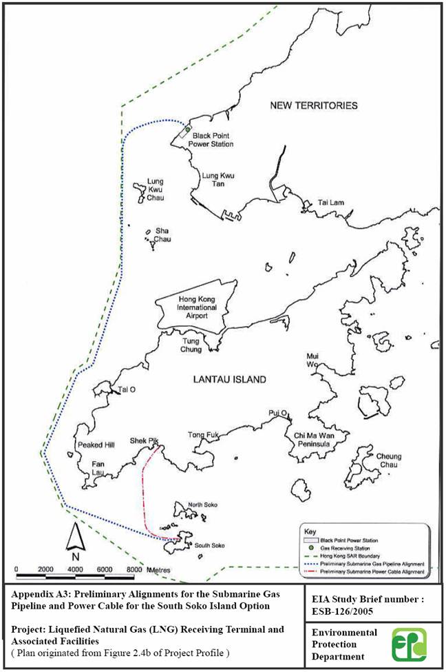
Appendix B-1
Guidelines on Choice of Models and Model Parameters
[The information contained in
this Appendix is only meant to assist the Applicant in performing the air
quality assessment. The Applicant
must exercise professional judgment in applying this general information for
the Project.]
1. Introduction
1.1 To expedite the review process
by the Authority and to assist project proponents or environmental consultants
with the conduct of air quality modelling exercise which are frequently called
for as part of environmental impact assessment studies, this paper describes
the usage and requirements of a few commonly used air quality models.
2.
Choice of Models
2.1 The
models which have been most commonly used in air quality impact assessments,
due partly to their ease of use and partly to the quick turn-around time for
results, are of Gaussian type and designed for use in simple terrain under
uniform wind flow. There are circumstances when these models are not suitable
for ambient concentration estimates and other types of models such as physical,
numerical or mesoscale models will have to be used. In situations where
topographic, terrain or obstruction effects are minimal between source and
receptor, the following Gaussian models can be used to estimate the near-field
impacts of a number of source types including dust, traffic and industrial
emissions.
Model Applications
FDM for
evaluating fugitive and open dust source impacts (point, line and area sources)
CALINE4 for
evaluating mobile traffic emission impacts (line sources)
ISCST3 for
evaluating industrial chimney releases as well as area and volumetric sources
(point, area and volume sources); line sources can be approximated by a number
of volume sources.
These
frequently used models are also referred to as Schedule 1 models (see attached
list).
2.2
Note
that both FDM and CALINE4 have a height limit on elevated sources (20 m and
10m, respectively). Source of elevation above these limits will have to be
modelled using the ISCST3 model or suitable alternative models. In using the
latter, reference should be made to the 'Guidelines on the Use of Alternative
Computer Models in Air Quality Assessment' in Appendix B-3.
2.3
The
models can be used to estimate both short-term (hourly and daily average) and
long-term (annual average) ambient concentrations of air pollutants. The model
results, obtained using appropriate model parameters (refer to Section 3) and
assumptions, allow direct comparison with the relevant air quality standards
such as the Air Quality Objectives (AQOs) for the relevant pollutant and time
averaging period.
3. Model
Input Requirements
3.1 Meteorological
Data
3.1.1 At
least 1 year of recent meteorological data (including wind speed, wind
direction, stability class, ambient temperature and mixing height) from a
weather station either closest to or having similar characteristics as the
study site should be used to determine the highest short-term (hourly, daily)
and long-term (annual) impacts at identified air sensitive receivers in that
period. The amount of valid data for the period should be no less than 90
percent.
3.1.2 Alternatively,
the meteorological conditions as listed below can be used to examine the worst
case short-term impacts:
Day
time: stability
class D; wind speed 1 m/s (at 10m height); worst-case wind angle; mixing height
500 m
Night
time: stability
class F; wind speed 1 m/s (at 10m height); worst case wind angle; mixing height
500 m
This
is a common practice with using the CALINE4 model due to its inability to
handle lengthy data set.
3.1.3 For
situations where, for example, (i) the model (such as CALINE4) does not allow
easy handling of one full year of meteorological data; or (ii) model run time
is a concern, the followings can be adopted in order to determine the daily and
annual average impacts:
(i)
perform
a frequency occurrence analysis of one year of meteorological data to determine
the actual wind speed (to the nearest unit of m/s), wind direction (to the
nearest 10o) and stability (classes A to F) combinations and their
frequency of occurrence;
(ii)
determine
the short term hourly impact under all of the identified wind speed, wind
direction and stability combinations; and
(iii)
apply
the frequency data with the short term results to determine the long term
(daily / annual) impacts.
Apart
from the above, any alternative approach that will capture the worst possible
impact values (both short term and long term) may also be considered.
3.1.4 Note that
the anemometer height (relative to a datum same for the sources and receptors)
at which wind speed measurements were taken at a selected station should be
correctly entered in the model. These measuring positions can vary greatly from
station to station and the vertical wind profile employed in the model can be
grossly distorted from the real case if incorrect anemometer height is used.
This will lead to unreliable concentration estimates.
3.1.5 An
additional parameter, namely, the standard deviation of wind direction, �m�K, needs to be provided as
input to the CALINE4 model. Typical values of�m�K range from 12o
for rural areas to 24o for highly urbanised areas under 'D' class
stability. For semi-rural such as new development areas, 18o is more
appropriate under the same stability condition. The following reference can be
consulted for typical ranges of standard deviation of wind direction under
different stability categories and surface roughness conditions.
Ref.(1): Guideline On Air Quality Models (Revised),
EPA-450/2-78-027R,
3.2 Emission
Sources
All
the identified sources relevant to a process plant or a study site should be
entered in the model and the emission estimated based on emission factors
compiled in the AP-42 (Ref. 2) or other suitable references. The relevant
sections of AP-42 and any parameters or assumptions used in deriving the
emission rates (in units g/s, g/s/m or g/s/m2) as required by the
model should be clearly stated for verification. The physical dimensions,
location, release height and any other emission characteristics such as efflux
conditions and emission pattern of the sources input to the model should also
correspond to site data.
If
the emission of a source varies with wind speed, the wind speed-dependent
factor should be entered.
Ref.(2): Compilation of Air Pollutant Emission Factors, AP-42, 5th
Edition,
3.3 Urban/Rural
Classification
Emission
sources may be located in a variety of settings. For modelling purposes these
are classed as either rural or urban so as to reflect the enhanced mixing that
occurs over urban areas due to the presence of buildings and urban heat
effects. The selection of either rural or urban dispersion coefficients in a
specific application should follow a land use classification procedure. If the
land use types including industrial, commercial and residential uses account
for 50% or more of an area within 3 km radius from the source, the site is
classified as urban; otherwise, it is classed as rural.
3.4 Surface
Roughness Height
This
parameter is closely related to the land use characteristics of a study area
and associated with the roughness element height. As a first approximation, the
surface roughness can be estimated as 3 to 10 percent of the average height of
physical structures. Typical values used for urban and new development areas
are 370 cm and 100 cm, respectively.
3.5 Receptors
These
include discrete receptors representing all the identified air sensitive
receivers at their appropriate locations and elevations and any other discrete
or grid receptors for supplementary information. A receptor grid, whether
Cartesian or Polar, may be used to generate results for contour outputs.
3.6 Particle
Size Classes
In
evaluating the impacts of dust-emitting activities, suitable dust size
categories relevant to the dust sources concerned with reasonable breakdown in
TSP (< 30 �gm) and RSP (< 10 �gm) compositions should be used.
3.7 NO2
to NOx Ratio
The
conversion of NOx to NO2 is a result of a series of
complex photochemical reactions and has implications on the prediction of near
field impacts of traffic emissions. Until further data are available, three
approaches are currently acceptable in the determination of NO2:
(a)
Ambient
Ratio Method (ARM) - assuming 20% of NOx to be NO2; or
(b)
Discrete
Parcel Method (DPM, available in the CALINE4 model); or
(c)
Ozone
Limiting Method (OLM) - assuming the tailpipe NO2 emission to be 7.5%
of NOx and the background ozone concentration to be in the range of
57 to 68 �gg/m3 depending on the land use type (see also the EPD
reference paper 'Guidelines on Assessing the 'TOTAL' Air Quality Impacts' in
Appendix B-2).
3.8 Odour
Impact
In
assessing odour impacts, a much shorter time-averaging period of 5 seconds is
required due to the shorter exposure period tolerable by human receptors.
Conversion of model computed hourly average results to 5-second values is
therefore necessary to enable comparison against recommended standard. The
hourly concentration is first converted to 3-minute average value according to
a power law relationship which is stability dependent (Ref. 3) and a result of
the statistical nature of atmospheric turbulence. Another conversion factor (10
for unstable conditions and 5 for neutral to stable conditions) is then applied
to convert the 3-minute average to 5-second average (Ref. 4). In summary, to
convert the hourly results to 5-second averages, the following factors can be
applied:
Stability
Category 1-hour
to 5-sec Conversion Factor
A &
B 45
C 27
D 9
E &
F 8
Under
��D�� class stability, the 5-second concentration is approximately 10 times the
hourly average result. Note, however, that the combined use of such conversion
factors together with the ISCST results may not be suitable for assessing the
extreme close-up impacts of odour sources.
Ref.(3): Richard A. Duffee, Martha A. O��Brien and Ned Ostojic, ��Odor
Modeling �V Why and How��, Recent Developments and Current Practices in Odor
Regulations, Controls and Technology, Air & Waste Management Association,
1991.
Ref.(4): A.W.C. Keddie, ��Dispersion of Odours��, Odour Control �V A
Concise Guide,
3.9 Plume
Rise Options
The
ISCST3 model provides by default a list of the
3.10 Portal
Emissions
These
include traffic emissions from tunnel portals and any other similar openings
and are generally modelled as volume sources according to the PIARC 91 (or more
up-to-date version) recommendations (Ref. 5, section III.2). For emissions
arising from underpasses or any horizontal openings of the like, these are
treated as area or point sources depending on the source physical dimensions.
In all these situations, the ISCST3 model or more sophisticated models will
have to be used instead of the CALINE4 model. In the case of portal emissions
with significant horizontal exit velocity which cannot be handled by the ISCST3
model, the impacts may be estimated by the TOP model (Ref. 6) or any other
suitable models subject to prior agreement with EPD. The EPD��s 'Guidelines on the Use of
Alternative Computer Models in Air Quality Assessment' should also be referred
to in Appendix B-3.
Ref.(5):
Ref.(6): N. Ukegunchi, H.
Okamoto and Y. Ide "Prediction of vehicular emission pollution around a
tunnel mouth", Proceedings 4th International Clean Air Congress, pp.
205-207,
3.11 Background
Concentrations
Background
concentrations are required to account for far-field sources which cannot be
estimated by the model. These values, to be used in conjunction with model
results for assessing the total impacts, should be based on long term average
of monitoring data at location representative of the study site. Please make
reference to the paper 'Guidelines on Assessing the 'TOTAL' Air Quality
Impacts' in Appendix B-2 for further information.
3.12 Output
The
highest short-term and long-term averages of pollutant concentrations at
prescribed receptor locations are output by the model and to be compared
against the relevant air quality standards specified for the relevant
pollutant. Contours of pollutant concentration are also required for indicating
the general impacts of emissions over a study area.
Copies
of model files in electronic format should also be provided for EPD's
reference.
------------------------------------------------------------------------------------------------------
Schedule 1
Air Quality Models
Generally Accepted by
Regulatory
Applications as at 1 July 1998*
Industrial
Source Complex Dispersion Model - Short Term Version 3 (ISCST3) or the latest version
developed by U.S. Environmental Protection Agency
California
Line Source Dispersion Model Version 4 (CALINE4) or the latest version developed by
Department of Transportation,
Fugitive Dust
Model (FDM)
or the latest version developed by U.S. Environmental Protection Agency
------------------------------------------------------------------------------------------------------
* EPD
is continually reviewing the latest development in air quality models and will
update this Schedule accordingly.
Appendix B-2
Guidelines on Assessing the 'TOTAL' Air Quality Impacts
[The information contained in
this Appendix is only meant to assist the Applicant in performing the air
quality assessment. The Applicant
must exercise professional judgment in applying this general information for
the Project.]
1. Total
Impacts - 3 Major Contributions
1.1
In
evaluating the air quality impacts of a proposed project upon air sensitive
receivers, contributions from three classes of emission sources depending on
their distance from the site should be considered. These are:
Primary
contributions: project
induced
Secondary
contributions: pollutant-emitting
activities in the immediate neighbourhood
Other
contributions: pollution
not accounted for by the previous two
(Background
contributions)
2. Nature
of Emissions
2.1 Primary
contributions
In
most cases, the project-induced emissions are fairly well defined and quite
often (but not necessarily) the major contributor to local air quality impacts.
Examples include those due to traffic network, building or road construction
projects.
2.2 Secondary
contributions
Within
the immediate neighbourhood of the project site, there are usually pollutant
emitting activities contributing further to local air quality impacts. For most
local scale projects, any emission sources in an area within 500m radius of the
project site with notable impacts should be identified and included in an air
quality assessment to cover the short-range contributions. In the exceptional
cases where there is one or more significant sources nearby, the study area may
have to be extended or alternative estimation approach employed to ensure these
impacts are reasonably accounted for.
2.3 Background
contributions
The
above two types of emission contributions should account for, to a great
extent, the air quality impacts upon local air sensitive receivers, which are
often amenable to estimation by the 'Gaussian Dispersion' type of models.
However, a background air quality level should be prescribed to indicate the baseline
air quality in the region of the project site, which would account for any
pollution not covered by the two preceding contributions. The emission sources
contributing to the background air quality would be located further afield and
not easy to identify. In addition, the transport mechanism by which pollutants
are carried over long distances (ranging from 1km up to tens or hundreds of
kms) is rather complex and cannot be adequately estimated by the 'Gaussian'
type of models.
3. Background
Air Quality - Estimation Approach
3.1 The
approach
In
view of the difficulties in estimating background air quality using the air
quality models currently available, an alternative approach based on monitored
data is suggested. The essence of this approach is to adopt the long-term
(5-year) averages of the most recent monitored air quality data obtained by
EPD. These background data would be reviewed yearly or biennially depending on
the availability of the monitored data. The approach is a first attempt to provide
a reasonable estimate of the background air quality level for use in
conjunction with EIA air quality assessment to address the cumulative impacts
upon a locality. This approach may be replaced or supplemented by superior
modelling efforts such as that entailed in PATH (Pollutants in the Atmosphere
and their Transport over Hong Kong), a comprehensive territory-wide air quality
modelling system currently being developed for Hong Kong. Notwithstanding this,
the present approach is based on measured data and their long term regional
averages; the background values so derived should therefore be indicative of
the present background air quality. In the absence of any other meaningful way
to estimate a background air quality for the future, this present background
estimate should also be applied to future projects as a first attempt at a
comprehensive estimate until a better approach is formulated.
3.2 Categorisation
The
monitored air quality data, by 'district-averaging' are further divided into
three categories, viz, Urban, Industrial and Rural/New Development. The
background pollutant concentrations to be adopted for a project site would
depend on the geographical constituency to which the site belongs. The
categorisation of these constituencies is given in Section 3.4. The monitoring
stations suggested for the 'district-averaging'(arithmetic means) to derive
averages for the three background air quality categories are listed as follows:
Urban: Kwun
Tong, Sham Shui Po, Tsim Sha Tsui and Central/Western
Industrial: Kwun
Tong, Tsuen Wan and Kwai Chung
Rural/New
Development: Sha
Tin, Tai Po,
The
averaging would make use of data from the above stations wherever available.
The majority of the monitoring stations are located some 20m above ground.
3.3 Background
pollutant values
Based
on the above approach, background values for the 3 categories have been
obtained for a few major air pollutants as follows:
|
POLLUTANT |
URBAN |
INDUSTRIAL |
RURAL
/ NEW DEVELOPMENT |
|
NO2 |
59 |
57 |
39 |
|
SO2 |
21 |
26 |
13 |
|
O3 |
62 |
68 |
57 |
|
TSP |
98 |
96 |
87 |
|
RSP |
60 |
58 |
51 |
All
units are in micrograms per cubic metre. The above values are derived from 1992
to 1996 annual averages with the exception of ozone which represent annual
average of daily hourly maximum values for year 1996.
In
cases where suitable air quality monitoring data representative of the study
site such as those obtained from a nearby monitoring station or on-site
sampling are not available for the prescription of background air pollution
levels, the above tabulated values can be adopted instead. Strictly speaking, the suggested values
are only appropriate for long term assessment. However, as an interim measure
and until a better approach is formulated, the same values can also be used for
short term assessment. This implies that the short term background values will
be somewhat under-estimated, which compensates for the fact that some of the
monitoring data are inherently influenced by secondary sources because of the
monitoring station location.
Indeed,
if good quality on-site sampling data which cover at least one year period are
available, these can be used to derive both the long term (annual) and short
term (daily / hourly) background values, the latter are usually applied on an
hour to hour, day to day basis.
3.4 Site
categories
The
categories to which the 19 geographical constituencies belong are listed as
follows:
|
DISTRICT |
AIR
QUALITY CATEGORY |
|
Islands |
Rural / New Development |
|
Southern |
Rural / New Development |
|
Eastern |
Urban |
|
Wan Chai |
Urban |
|
Central & Western |
Urban |
|
Sai Kung |
Rural / New Development |
|
Kwun Tong |
Industrial |
|
Wong Tai Sin |
Urban |
|
|
Urban |
|
Yau Tsim |
Urban |
|
Mong Kok |
Urban |
|
Sham Shui Po |
Urban |
|
Kwai Tsing |
Industrial |
|
Sha Tin |
Rural / New Development |
|
Tsuen Wan |
Industrial |
|
Tuen Mun |
Rural / New Development |
|
Tai |
Rural / New Development |
|
Yuen Long |
Rural / New Development |
|
Northern |
Rural / New Development |
3.5 Provisions
for 'double-counting��
The
current approach is, by no means, a rigorous treatment of background air
quality but aims to provide an as-realistic-as-possible approximation based on
limited field data. 'Double-counting' of 'secondary contributions' may be
apparent through the use of such 'monitoring-based' background data as some of
the monitoring stations are of close proximity to existing emission sources.
'Primary contributions' due to a proposed project (which is yet to be realized)
will not be double-counted by such an approach. In order to avoid
over-estimation of background pollutant concentrations, an adjustment to the
values given in Section 3.3 is possible and optional by multiplying the
following factor:
(1.0 - ESecondary contributions/ETerritory)
where E stands for emission.
The
significance of this factor is to eliminate the fractional contribution to
background pollutant level of emissions due to 'secondary contributions' out of
those from the entire territory. In most cases, this fractional contribution to
background pollutant levels by the secondary contributions is minimal.
4. Conclusions
The
above described approach to estimating the total air quality impacts of a
proposed project, in particular the background pollutant concentrations for air
quality assessment, should be adopted with immediate effect. Use of short term
monitoring data to prescribe the background concentrations is no longer
acceptable.
in Air Quality Assessment
[The information contained in
this Appendix is only meant to assist the Applicant in performing the air
quality assessment. The Applicant
must exercise professional judgment in applying this general information for
the Project.]
1. Background
1.1
In
1.2
However,
no single model is sufficient to cover all situations encountered in regulatory
applications. In order to ensure that the best model available is used for each
regulatory application and that a model is not arbitrarily applied, the project
proponent (and/or its environmental consultants) should assess the capabilities
of various models available and adopt one that is most suitable for the project
concerned.
1.3
Examples
of situations where the use of an alternative model is warranted include:
(i)
the complexity of the situation to be modelled
far exceeds the capability of the Schedule 1 models; and
(ii) the
performance of an alternative model is comparable or better than the Schedule 1
models.
1.4 This
paper outlines the demonstration / submission required in order to support the
use of an alternative air quality model for regulatory applications for
2. Required
Demonstration / Submission
2.1 Any
model that is proposed for air quality applications and not listed amongst the
Schedule 1 models will be considered by EPD on a case-by-case basis. In such cases, the proponent will have
to provide the followings for EPD's review:
(i)
Technical
details of the proposed model; and
(ii)
Performance
evaluation of the proposed model
Based
on the above information, EPD will determine the acceptability of the proposed
model for a specific or general applications. The onus of providing adequate
supporting materials rests entirely with the proponent.
2.2 To
provide technical details of the proposed model, the proponent should submit
documents containing at least the following information:
(i)
mathematical
formulation and data requirements of the model;
(ii)
any
previous performance evaluation of the model; and
(iii)
a
complete set of model input and output file(s) in commonly used electronic
format.
2.3.1
On
performance evaluation, the required approach and extent of demonstration
varies depending on whether a Schedule 1 model is already available and
suitable in simulating the situation under consideration. In cases where no
Schedule 1 model is found applicable, the proponent must demonstrate that the
proposed model passes the screening test as set out in USEPA Document "Protocol
for Determining the Best Performing Model" (Ref. 1).
Ref.(1): William M. Cox, ��Protocol for
Determining the Best Performing Model��; Publication No. EPA-454/R-92-025;
2.3.2
For
cases where a Schedule 1 model is applicable to the project under consideration
but an alternative model is proposed for use instead, the proponent must
demonstrate either that
(i)
the
highest and second highest concentrations predicted by the proposed model are
within 2 percent of the estimates obtained from an applicable Schedule 1 model
(with appropriate options chosen) for all receptors for the project under
consideration; or
(ii)
the
proposed model has superior performance against an applicable Schedule 1 model
based on the evaluation procedure set out in USEPA Document "Protocol for Determining the Best
Performing Model" (Ref. 1).
2.3.3
Should
EPD find the information on technical details alone sufficient to indicate the
acceptability of the proposed model, information on further performance
evaluation as specified in Sections 2.3 and 2.4 above would not be necessary.
2.3.4
If
the proposed model is an older version of one of the Schedule 1 models or was
previously included in Schedule 1, the technical documents mentioned in Section
2.2 are normally not required.
However, a performance demonstration of equivalence as stated in Section
2.4 (i) would become necessary.
2.3.5
If
EPD is already in possession of some of the documents that describe the
technical details of the proposed model, submission of the same by the
proponent is not necessary. The proponent may check with EPD to avoid sending
in duplicate information.
-------------------------------------------------------------------------------------------------------
Regulatory
Applications as at 1 July 1998*
Industrial
Source Complex Dispersion Model - Short Term Version 3 (ISCST3) or the latest version
developed by U.S. Environmental Protection Agency
California
Line Source Dispersion Model Version 4 (CALINE4) or the latest version developed by
Department of Transportation,
Fugitive
Dust Model (FDM)
or the latest version developed by U.S. Environmental Protection Agency
-------------------------------------------------------------------------------------------------------
* EPD
is continually reviewing the latest development in air quality models and will
update this Schedule accordingly.
Appendix C
Water Quality Modelling Requirements
(Project Title
: Liquefied Natural Gas (LNG) Receiving Terminal and Associated Facilities)
1. The
modelling software shall be fully 3-dimensional capable of accurately
simulating the stratified condition, salinity transport, and effects of wind and tide on the water
body within the model area.
2. The
modelling software shall consist of hydrodynamic, water quality, sediment transport,
thermal and particle dispersion modules.
The hydrodynamic, water quality, sediment transport and thermal modules shall
have been proven with successful applications locally and overseas.
3. The
hydrodynamic,
water quality, sediment
transport and
thermal modules shall be strictly mass conserved at all levels.
4. The
assessment and modelling tool for spill events should be quantitative with
proven applications locally or overseas.
5. An
initial dilution model shall be used to characterize the initial mixing of the
effluent discharge, and to feed the terminal level and size of the plume into
the far field water quality modules where necessary. The initial dilution model shall have
been proven with successful applications locally and overseas.
Model details �V Calibration &
Validation
1. No
field data collection is required for model calibration for this study. However, the models shall be properly
calibrated and validated before its use in this study in the
�P Hydraulic and Water Quality
Studies in
�P Port and Airport Development Strategy -
Enhancement of WAHMO
Mathematical Models (1990)
�P Strategic Sewage Disposal Scheme Stage II
- Oceanic Outfall, Oceanographic Surveys and Modelling (1992)
�P Update on Cumulative Water Quality and
Hydrological Effect of Coastal Developments and Upgrading of Assessment Tool
(1998)
�P Environmental Protection
Department (EPD)��s routine monitoring data
�P Tidal data from Hong Kong
Observatory,
2. Tidal
data shall be calibrated and validated in both frequency and time domain
manner.
3. For
the purpose of calibration and validation, the model shall run for not less
than 15 days of real sequence of tide (excluding model spin up) in both dry and
wet seasons with due consideration of the time required to establish initial
conditions.
4. In
general the hydrodynamic models shall be calibrated to the following criteria:
Criteria Level
of fitness
with
field data
�P tidal elevation (rms) <
8 %
�P maximum phase error at high water and
low water <
20 minutes
�P maximum current speed deviation <
30 %
�P maximum phase error at peak speed <
20 minutes
�P maximum direction error at peak speed <
15 degrees
�P maximum salinity deviation <
2.5 ppt
Model details �V Simulation
1. The
water quality modelling results shall be qualitatively explainable, and any
identifiable trend and variations in water quality shall be reproduced by the
model. The water quality model
shall be able to simulate and take account of the interaction of dissolved
oxygen, phytoplankton, organic and inorganic nitrogen, phosphorus, silicate,
BOD, temperature, suspended solids, contaminants release of dredged and
disposed material, air-water exchange, E.
coli and benthic processes. It
shall also simulate salinity.
Salinity results simulated by hydrodynamic models and water quality
models shall be demonstrated to be consistent.
2. The
sediment transport module for assessing impacts of sediment loss
due to marine works shall include the processes of settling, deposition and
re-erosion. The values of the
modelling parameters shall be agreed with EPD. Contaminants release and DO depletion
during dredging and dumping shall be simulated by the model.
3. The
thermal model shall be based on the flow field produced by the hydrodynamic
model. It shall incorporate the
physical processes of thermal / cooled water discharge and abstraction flow,
buoyancy effect of the thermal plume, and surface heat exchange. Dispersion of biocides in the discharge
shall also be simulated with appropriate decay rates. Initial dilution model shall be used to
quantify the initial mixing of the thermal / cooled water discharge.
4. The
models shall at least cover the
5. In
general, grid size at the area affected by the project shall be less than 400 m
in open waters and less than 75 m around sensitive receivers. The
grid schematization shall be agreed with EPD.
Modelling assessment
1. The
assessment shall include the construction and operation phases of the
project. Where appropriate, the
assessment shall also include maintenance dredging. Scenarios to be assessed shall cover the baseline condition and scenarios with various
different options proposed by the Applicant in order to quantify the
environmental impacts and improvements that will be brought about by these
options. Corresponding
pollution load, bathymetry and coastline shall be adopted in the model set
up.
2. Hydrodynamic, water quality, sediment
transport and thermal modules, where appropriate,
shall be run for (with proper model spin up) at least a real sequence of 15
days spring-neap tidal cycle in both the dry season and the wet season.
3. The
assessment shall cover accidental spillage of both LNG & fuel of the
carriers. Potential locations,
quantities and rates of spill shall be identified and quantified. The spill modelling shall cover
combinations of different tides, wind and season conditions. The methodology for modelling spill and
scenarios to be covered should be agreed with EPD.
4. The
results shall be assessed for compliance of Water Quality Objectives. Any
changes in hydrodynamic regime shall be assessed. Daily erosion / sedimentation rate shall
be computed and its ecological impact shall be assessed.
5. The
impact on all sensitive receivers shall be assessed.
6. Cumulative
impacts due to other projects, activities or pollution sources within a
boundary to the agreement of EPD shall also be predicted and quantified.
7. All
modelling input data and results shall be submitted in digital media to EPD.
Appendix D
Criteria
for Cultural Heritage Impact Assessment
(1) Baseline
Study
1.1 A
baseline study shall be conducted :
(a)
To compile
a comprehensive inventory of archaeological sites (including marine
archaeological sites), historic buildings and structures within the proposed
project area, which include :
(i) All
sites of archaeological interest (including marine archaeological sites);
(ii) All
pre-1950 buildings and structures;
(iii) Selected
post-1950 buildings and structures of high architectural and historical
significance and interest; and
(iv) Landscape
features include sites of historical events or providing a significant
historical record or a setting for buildings or monuments of architectural or
archaeological importance, historic field patterns, tracks and fish ponds and
cultural element such as fung shui woodlands and clan graves.
(b) To
identify the direct and indirect impacts on the site of cultural heritage at
the planning stage in order to avoid causing any negative effects. The impacts include the direct loss,
destruction or disturbance of an element of cultural heritage, impact in its
settings causing impinge on its character through inappropriate sitting or
design, potential damage to the physical fabric of archaeological remains, historic
buildings or historic landscapes through air pollution, change of water-table,
vibration, recreation pressure and ecological damage by the development. The impacts listed are merely to
illustrate the range of potential impacts and not intended to be exhaustive.
1.2 The
baseline study shall also include a desk-top study and a field survey.
1.3 Desk-top
Research
1.3.1
Desk-top searches should be
conducted to analyse, collect and collate extant information. They include :
(a) Search of
the list of declared monuments protected by the Antiquities and Monuments
Ordinance (Chapter 53).
(b) Search
of the list of deemed monuments through the Antiquities and Monuments Office
(AMO) of the Leisure and Cultural Services Department.
(c) Search
of the list of sites of cultural heritage identified by the AMO.
(d) Search
of publications on local historical, architectural, anthropological,
archaeological and other cultural studies, such as, Journals of the Royal
Asiatic Society (Hong Kong Branch), Journals of the Hong Kong Archaeological
society, Antiquities and Monuments Office Monograph Series and so forth.
(e) Search
of other unpublished papers, records, archival and historical documents through
public libraries, archives, and the tertiary institutions, such as the Hong
Kong Collection and libraries of the Department of Architecture of the
(f) Search of any other unpublished archaeological
investigation and excavation reports kept by the AMO.
(g) Search
of historical documents in the Public Records Office, the Land Registry,
District Lands Office, District Office and the Hong Kong Museum of History and
so forth.
(h) Search
of cartographic and pictorial documents.
Maps of the recent past searched in the Maps and Aerial Photo Library of
the Lands Department.
(i) Study of existing Geotechnical information (for
archaeological desk-top research).
(j) Discussion with local informants.
1.4 Field
Evaluation
1.4.1 The potential value of the
development site with regard to the cultural heritage could be established
easily where the site is well-documented.
However, it does not mean that the site is devoid of interest if it
lacks information. In these
instances, a site visit combined with discussions with appropriate individuals
or organisations should be conducted by those with expertise in the area of
cultural heritage to clarify the position.
1.4.2 Historic buildings and
structures survey
(a) Field scan
of all the historic buildings and structures within the project area.
(b) Photographic
recording of each historic building or structure including the exterior (the
elevations of all faces of the building premises, the roof, close up for the
special architectural details) and the interior (special architectural
details), if possible, as well as the surroundings of each historic building or
structure.
(c) Interview
with local elders and other informants on the local historical, architectural,
anthropological and other cultural information related to the historic
buildings and structures.
(d) Architectural
appraisal of the historic buildings and structures.
1.4.3 Archaeological Survey
A
detailed archaeological field evaluation programme should be designed to assess
the archaeological potential of the project area. The programme should clearly
elaborate the strategy and methodology adopted, including what particular
question(s) can be resolved, how the archaeological data will be collected and
recorded, how the evidence will be analysed and interpreted and how the
archaeological finds and results will be organized and made available. Effective field techniques should also
be demonstrated in the programme such as the following (but not limited to):
(a) Definition
of areas of natural land undisturbed in the recent past.
(b) Field scan
of the natural land undisturbed in the recent past in detail with special
attention paid to areas of exposed soil which were searched for artifacts.
(c) Conduct
systematic auger survey/shovel testing at 20m interval to establish the
horizontal spread of cultural materials deposits.
(d) Excavation
of test pits to establish the vertical sequence of cultural materials. The hand digging of 1 x 1m or 1.5 x 1.5m
test pits to determine the presence or absence of deeper archaeological
deposits and their cultural history.
1.4.4 If the field evaluation
identifies any additional sites of cultural heritage within the study area
which are of potential historic or archaeological importance and not recorded
by AMO, the office should be reported as soon as possible. The historic and archaeological value of
the items will be further assessed by the AMO.
1.5 The
Report of Baseline Study
1.5.1 The study report should have
concrete evidence to show that the process of the above desk-top and field
survey has been satisfactorily completed.
This should take the form of a detailed inventory of the sites of
cultural heritage supported by full description of their cultural
significance. The description
should contain detailed geographical, historical, archaeological,
architectural, anthropological, ethnographic and other cultural data
supplemented with illustrations below the photographic and cartographic
records.
1.5.2 Historic Buildings and
Structures
(a)
A map in 1:1000
scale showing the boundary of each historic building or structure.
(b)
Photographic
records of each historic building or structure.
(c) Detailed
record of each historic building or structure including its construction year,
previous and present uses, architectural characteristics, as well as legends,
historic persons and events, and cultural activities associated with the
structure.
1.5.3 Archaeological Sites
(a) A map
showing the boundary of each archaeological site as supported and delineated by
field walking, auguring and test-pitting;
(b) Drawing of
stratigraphic section of test-pits excavated which shows the cultural sequence
of a site.
1.5.4 A full bibliography and the
source of information consulted should be provided to assist the evaluation of
the quality of the evidence. It is
expected that the study and result are up to an internationally accepted
academic and professional standard.
(2) Impact
Assessment
2.1 Culture
heritage impact assessment must be undertaken to identify the impacts of the
sites of cultural heritage which will be affected by the proposed development
subject to the result of desktop research and field evaluation. The prediction of impacts and an
evaluation of their significance must be undertaken by an expert in cultural
heritage. During the assessment,
both the direct impacts such as loss or damage of important features as well as
indirect impacts such as change of water table levels which may affect the
preservation of the archaeological and built heritage in situ should be
stated. A detailed description and
plans should be provided to elaborate to what extent the site of cultural
heritage will be affected.
2.2 Preservation
in totality must be taken as the first priority. Please refer to paragraph 4.3.1(c), item
2 of Annex 10, items 2.6 to 2.9 of Annex 19 and other relevant parts of the
Technical Memorandum on Environmental Impact Assessment Process for the
detailed requirements of the impact assessment.
(3) Mitigation
Measures
3.1 It
is always a good practice to recognise the site or monument early in the
planning stage and site selection process, and to avoid it, i.e. preserve it
in-situ, or leaving a buffer zone around the site. Built heritage, sites and landscapes are
to be in favour of preservation unless it can be shown that there is a need for
a particular development which is of paramount importance and outweighs the
significance of the heritage feature.
3.2 If
avoidance of the cultural heritage is not possible, amelioration can be
achieved by reduction of the potential impacts and the preservation of heritage
features, such as physically relocating it. Measures like amendments of the sitting,
screening and revision of the detailed design of the development are required
to lessen its degree of exposure if it causes visual intrusion to the cultural
heritage and affecting its character.
3.3 All
the assessments should be conducted by an expert in cultural heritage and
further evaluated and endorsed by the Antiquities and Monuments Office and the
Antiquities Advisory Board.
3.4 Besides
referring to paragraph 4.3.1(d), items 2.10 to 2.14 of Annex 19 and other
relevant parts of the Technical Memorandum, proposals for mitigation measures
should be accompanied with a master layout plan together with all detailed
treatment, elevations, and landscape plan.
A rescue programme, when required, may involve preservation of the
historic building or structure together with the relics inside, and its
historic environment through relocation, detailed cartographic and photographic
survey or preservation of an archaeological site ��by record��, i.e. through
excavation to extract the maximum data as the very last resort.
3.5 The
programme for implementation of agreed mitigation measures should be able to be
implemented. It is to be clearly
stated in the EIA report, as required in Annex 20 of the Technical Memorandum. In particular, item 6.7 of Annex 20
requires to define and list out clearly the proposed mitigation measures to be
implemented, by whom, when, where, to what requirements and the various
implementation responsibilities. A
comprehensive plan and programme for the protection and conservation of the partially
preserved Site of Cultural Heritage, if any, during the planning and design
stage of the proposed project must be detailed.
Guidelines for Marine Archaeological
Investigation (MAI)
The standard practice for MAI should consist of four
separate tasks, i.e. (1) Baseline Review, (2) Geophysical Survey, (3)
Establishing Archaeological Potential and (4) Remote Operated Vehicle
(ROV)/Visual Diver Survey/Watching Brief.
(1) Baseline Review
1.1 A baseline review
should be conducted to collate the existing information in order to identify
the potential for archaeological resources and, if identified, their likely
character, extent, quality and value.
1.2 The baseline review
will focus on known sources of archive data. It will include:
a. Geotechnical
Engineering Office (GEO) �V the Department holds extensive seabed survey data
collected from previous geological research.
b. Marine
Department, Hydrographic Office �V the Department holds a substantial archive of
hydrographic data and charts.
c. The
Royal Naval Hydrographic Department in the
1.3 The above data sources
will provide historical records and more detailed geological analysis of
submarine features which may have been subsequently masked by more recent
sediment deposits and accumulated debris.
(2) Geophysical
Survey
2.1 Extensive geophysical
survey of the study area should be deployed by using high resolution boomer,
side scan sonar and an echo sounder.
The data received from the survey would be analysed in detail to
provide:
a. Exact
definition of the areas of greatest archaeological potential.
b. Assessment
of the depth and nature of the seabed sediments to define which areas consist
of suitable material to bury and preserve archaeological material.
c. Detailed
examination of the boomer and side scan sonar records to map anomalies on the
seabed which may be archaeological material.
(3) Establishing
Archaeological Potential
3.1 The data examined
during Tasks 1 and 2 will be analysed to provide an indication of the likely
character and extent of archaeological resources within the study area. This would facilitate formulation of a
strategy for investigation.
3.2 The results would be
presented as a written report and charts.
If there is no indication of archaeological potential there would be no
need for Task 4.
(4) Remote Operated
Vehicle (ROV)/Visual Diver Survey/Watching Brief
4.1 Subject to the outcome
of Tasks 1, 2 and 3, accepted marine archaeological practice would be to plan a
field evaluation programme to acquire more detailed data on areas identified as
having archaeological potential.
The areas of archaeological interest can be inspected by ROV or
divers. ROV or a team of divers
with both still and video cameras would be used to record all seabed features
of archaeological interest.
4.2 Owing to the heavy
marine traffic in
4.3 A sampling strategy for
an archaeological watching brief would be prepared based on the results of
Tasks 1, 2 and 3 to focus work on the areas of greatest archaeological
potential. Careful monitoring of
the dredging operations would enable immediate identification and salvage of
archaeological material. If
archaeological material is found, the AMO should be contacted immediately to
seek guidance on its significance and appropriate mitigation measures would be
prepared.
4.4 If Task 4 is
undertaken, the results would be presented in a written report with charts.
|
|
EM&A |
|
Location/Duration of measures/ |
Implementation |
Implementation Stage ** |
Relevant Legislation & |
|||
|
EIA* Ref. |
Log Ref. |
Environmental Protection Measures* |
Timing of completion of measures |
Agent |
Des |
C |
O |
Dec |
Guidelines |
|
|
|
|
|
|
|
|
|
|
|
|
|
|
|
|
|
|
|
|
|
|
|
|
|
|
|
|
|
|
|
|
|
|
|
|
|
|
|
|
|
|
|
|
|
|
|
|
|
|
|
|
|
|
|
|
|
|
|
|
|
|
|
|
|
|
|
|
|
|
|
|
|
|
|
|
|
|
|
|
|
|
|
|
|
|
|
|
|
|
|
|
|
|
|
|
|
|
|
|
|
|
|
|
|
|
|
|
|
|
|
|
|
|
|
|
|
|
|
|
|
|
|
|
|
|
|
|
|
|
|
|
|
|
|
|
|
|
|
|
|
|
|
|
|
|
|
|
|
|
|
|
|
|
|
|
|
|
|
|
|
|
|
|
|
|
|
|
|
|
|
|
|
|
|
|
|
|
|
|
|
|
|
|
|
|
|
|
|
|
|
|
|
|
|
|
|
|
|
|
|
|
|
|
|
|
|
|
|
|
|
|
|
|
|
|
|
|
|
|
|
|
|
|
|
|
|
|
|
|
|
|
|
|
|
|
|
|
|
|
|
|
|
|
|
|
|
|
|
|
|
|
|
* All
recommendations and requirements resulted during the course of EIA Process,
including ACE and/or accepted public comment to the proposed project.
** Des=Design; C=Construction; O=Operation; Dec=Decommissioning
----
END OF STUDY BRIEF ----