 |
|
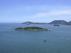
Hong Kong marine water
|
|
For a land area of just 1,104 km², Hong Kong
has a phenomenal amount of coastline: 456 km is the length of the
coastline running round the main area of Hong Kong from one side
of the New Territories to the other, while the 263 islands in Hong
Kong waters between them have another 722 km of coastline. In short,
Hong Kong is swathed in and surrounded by the sea, and includes
1,651 km² of marine water within its boundaries for which it is
directly responsible.
Hong Kong is on the southern coast of China
within the South China Sea environ and at the eastern edge of the
Pearl River estuary. Its western waters are affected by the large
flows from the Pearl River, particularly in the summer rainy season.
By contrast, the eastern waters are more strongly influenced by
oceanic currents, specifically the Hainan Current in the summer
(which flows from the south-west to the north-east) and the Kuroshio
Current in the winter (which flows in the opposite direction). Tropical
cyclones and strong monsoon winds also play a role in mixing of
the water masses.
Within marine waters covering about 1700 km²,
Hong Kong enjoys a remarkable range of different marine environments.
The deeper waters to the east of the territory (which average between
20 and 30 metres in depth) have high clarity and salinity (salt
content), and are basically oceanic. By contrast, Deep Bay to the
west has strong estuarine characteristics, meaning the water there
is mixed with river flow, is low in salinity, typically shallow
(averaging 4 to 10 metres in depth), silty and turbid.
Between these two areas is the natural deep-water
Victoria Harbour, which goes down as far as 42 metres in places.
Elsewhere, there are semi-enclosed bodies of water in Tolo Harbour,
Port Shelter, Mirs Bay in the east and Deep Bay in the west, and
a number of smaller sheltered areas enclosed by breakwaters which
include typhoon shelters, boat anchorages and marinas.
 |
|
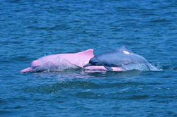
The famous Chinese white
dolphins
in Hong Kong waters
|
|
Long before human settlers arrived in Hong
Kong, the region's marine waters supported a huge range of sub-tropical
aquatic life. In the clearer oceanic waters of the east, sponges,
corals and sea grasses thrived, along with numerous species of crustaceans,
molluscs and fish. Meanwhile, the western waters became home of
the famous Chinese white dolphins and porpoises.
Human beings have long harvested the wealth
of the seas around Hong Kong through fishing (including fish farming
and oyster cultivation), but that has been only one of many roles
the sea has played in Hong Kong life. As Hong Kong has developed
into one of the world's largest and most important ports, navigation
through Hong Kong waters has increased immensely. The sea is also
widely used for recreation and sports, with hundreds of thousands
of Hong Kongers visiting beaches to swim or surf in the summer,
diving to see the beautiful corals or getting out on the waves in
boats of every description. Further, Hong Kong's marine waters are
used for a number of very practical purposes, including for cooling
in power plants and air conditioning systems, for toilet flushing,
and as a way of disposing of treated effluent.
Challenges to Hong Kong's marine environment
Hong Kong's population began to rise in leaps
and bounds in the 1970s and 1980s, and this was accompanied by intensive
industrial and urban development. Pressure began to build up on
the territory's marine waters, and the marine environment started
showing signs of strain. To begin with, most of Hong Kong's sewage
and wastewater ended up in the sea, but the bulk of it had received
little or no treatment before discharge due to the lack of a developed
sewer network and treatment facilities at that time. This led to
rises in organic and inorganic pollutants, a reduction in the oxygen
content of the water, and increased bacteria levels.
The problem was exacerbated by the rapid explosion
of Hong Kong's population: by 2005, this had risen to 6.9 million
people who were generating around 2 million tonnes of wastewater
every day. To house the rising population the Government began building
new towns in the 1980s, and while these proved to be masterful solutions
to social and demographic issues, they did not always bring equal
benefits to the surrounding environment. For example, two of them
(Sha Tin and Tai Po) were built in the catchment area for Tolo Harbour,
which due to its enclosed nature was highly sensitive to any increases
in pollutants flowing into it.
Another major problem affecting the quality
of Hong Kong's marine waters was the untreated waste generated by
the livestock industry twenty years ago. Young Hong Kongers may
be surprised to discover that, in the early 1980s, most parts of
the New Territories and some urban areas were home to thousands
of pig farms and chicken farms. Most of the large volumes of effluent
deriving from these farms was disposed of directly into Hong Kong's
rivers, which washed the pollution out to sea.
A further challenge to Hong Kong's
marine waters came in the form of mud. Prior to the 1980s, the dumping
of dredged mud from reclamation work and other urban development
projects was largely unregulated. Dredged mud, which in some cases
was contaminated, could be removed from one area of the sea bed
and dumped elsewhere without restrictions, bringing disturbance
to life on the sea floor and altering key characteristics of the
marine environment.
Finally, it pays to remember
that in the 1980s Hong Kong was home to far more industrial enterprises
that it is today, when many factory owners have moved their production
facilities across the border. Twenty years ago, thousands of factories-particularly
in the Kwun Tong and Tsuen Wan areas-discharged their untreated
industrial waste directly into sewers that flowed into the sea.
This waste was typically high in chemical and metal content, originating
as it did from factories involved in the textile, electroplating,
PCB, bleaching and dyeing industries amongst others.
Government responses to protect the marine environment
In short, by the early 1980s some of Hong Kong's
waters were being severely threatened by a mixture of pollution
sources, while pollution controls were mostly largely inadequate.
In response, the Government created an important blueprint for improving
Hong Kong's marine waters under the new Water Pollution Control
Ordinance. It divided all Hong Kong's marine water into ten Water
Control Zones (WCZs), each of which was given boundaries based on
water catchments and geographical characteristics. Then, the Government
established a set of Water Quality Objectives (WQOs) and discharge
standards for each WCZ. These WQOs laid out the qualitative and
quantitative characteristics of water that need to be achieved to
meet conservation goals and to support the various beneficial uses
of different areas of water. They were designed to act as long-term
environmental goals that would safeguard Hong Kong's marine environment.
Other initiatives of the time included the 1986 Dumping at Sea Ordinance,
which began to control the dumping of dredged mud in territorial
waters. In 1997 the Government enacted the Environmental Impact
Assessment Ordinance (EIAO), which laid out a framework for controlling
the environmental impact (including any impact on the marine environment)
of major development projects such as coastal reclamation. Further
details of the steps taken by the Government to address and control
water pollution problems are given in the next few chapters of this
report.
 |
|
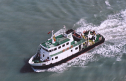
The EPD monitoring vessel,
"Dr. Catherine Lam"
|
|
In 1986, the Environmental Protection Department
(EPD) was established and entrusted with the task of monitoring
Hong Kong's marine water. To do this it devised a comprehensive
marine water monitoring programme, first implemented in 1986 and
since then revised and further expanded. The monitoring programme
is crucial for measuring to what extent individual Water Control
Zones comply with the WQOs, and over time a huge database of information
has been built up that enables long-term water quality changes to
be detected. Based on this scientific information, the Government
is able to assess the effectiveness of its pollution control measures,
and plan further strategies.
The programme operates according to a set of
very clear aims and objectives, as follows:
- to indicate the state of health of coastal
waters;
- to assess compliance with the statutory
WQOs;
- to reveal long-term changes in water quality;
- to provide a basis for the planning of water
pollution control strategies.
In the past twenty years, the work of the EPD
in monitoring marine water quality and implementing initiatives
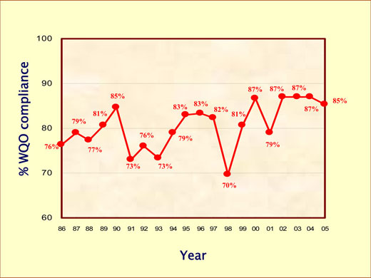
for reducing pollution has borne fruit. Overall compliance with
the key Water Quality Objectives across Hong Kong waters has improved
from 76% in 1986 to 85% and above since 2002. In the 1980s, 'red
tides' were a very serious problem for Tolo Harbour. Since then,
the frequency of their occurrence has been greatly reduced, as have
general levels of nutrients and organic and other inorganic pollutants
in many areas of Hong Kong's marine waters.
 |
|
 |
|
| Overall compliance with
the marine Water Quality Objectives in Hong Kong,
1986-2005 |
|
|
 |
 |
|
 |
|
In areas such as Port Shelter, which has historically recorded excellent
water quality, the EPD's efforts have ensured that water there has
remained of high quality despite a steady increase in local population.
In Victoria Harbour, meanwhile, the introduction of the Harbour
Area Treatment Scheme (HATS) Stage 1 has resulted in 1.4 million
cubic metres of sewage a day (or approximately 75% of the sewage
entering the harbour) being treated. This has had a very positive
impact on water quality in many parts of the harbour, especially
at the eastern end.
The achievements
of the EPD and the Government in reducing marine water pollution
are particularly evident in areas where Hong Kong's marine waters
are relatively enclosed, near urban areas, and receive large volumes
of waste water, such as Tolo Harbour and Victoria Harbour. Elsewhere,
changes tend to be less dramatic, because the ocean has a huge ability
to dilute and assimilate pollutants entering it. Aside from pollution,
other wider phenomena may also influence Hong Kong's waters, such
as the effects of the Pearl River outflow further west, rainstorms,
and even global changes such as the El Nino phenomenon or global
warming. In the last 20 years, the monitoring detected an overall
rise of sea water temperature of 0.3 ℃
in the territory.
The water quality of most parts of Hong Kong's
waters is relatively stable and generally slow to respond to specific
sources of pollution. In addition to assessing effects of pollution
and the mitigation measures implemented, the EPD's monitoring work
is also carried out to gather long-term information that can enable
more gradual trends to be identified and analysed. This more general
understanding of the marine environment is something the EPD aims
to achieve for all the marine waters it monitors. The more data
collected by the EPD that can help in understanding the condition
and behaviour of Hong Kong's marine environment today, the better
will the Government be able to recognise and respond to future changes
and new challenges that may arise.
Comprehensive marine water information available
to all
The EPD has made
special efforts to make sure the information it gathers from its
marine monitoring programme is widely available to everyone. It
publishes comprehensive water quality reports annually, and uploads
regular water quality information onto its website. This data is
widely used by Government policy makers, planners and analysts for
assessing the impact on water quality of various marine-related
developments such as reclamation and sewage discharge projects.
This report marks
the twentieth year of the EPD's marine water monitoring programme.
Normally, the EPD publishes an annual report each year, but in recognition
of this anniversary the EPD has this year put together a 20-year
historical survey of its work over the past two decades. This report
is designed to offer a detailed picture of the monitoring programme
and how it has developed over time, as well as outlining some of
the improvements in Hong Kong's marine water profile that have been
achieved over the last twenty years.
|