1
Introduction
ERM-Hong Kong, Limited (ERM) has been commissioned by the Castle Peak Power Company Limited (CAPCO) to undertake
the EIA for a proposed LNG terminal at
The purpose of the archaeological
survey is to investigate the presence of any archaeological deposits within 100
m from the boundary of the proposed development in Tai A Chau
(see Figure 1.1)
and the proposed cable and watermain landing point at
Shek Pik (see Figure
1.2). Where
archaeological remains are identified, their nature, horizontal and vertical
extent has been determined.
Prior to archaeological survey
commencement, a Licence to conduct the archaeological survey and an Excavation
Permit were obtained from the Antiquities and Monuments Office (AMO) under
the Antiquities and Monuments Ordinance (Cap. 53) and the District Land
Office (Islands) under the Land (Miscellaneous Provisions) Ordinance (Cap. 28) respectively.
As the development boundary has been
revised to include a larger area during the course of the Study as shown in Figure
1.1, two archaeological surveys was undertaken. The fieldworks were
undertaken at
1.2
Archaeological Survey Team Members
The following
individuals that participated in the archaeological surveys:
Mr Steven Ng of ERM Project Field Director,
Licensed Archaeologist;
Ms Peggy Wong of ERM Trained
Field Archaeologist;
Mr Wong Fu Trained Field
Archaeologist; and
Ms Zoe
Chan of ERM Trained Assistant Field
Archaeologist.
In addition to the
above team members, eight trained labourers were
employed to assist in the surveys and a team of qualified Land Surveyors from Land
Marker (1980) HK Company Limited assisted with the
land surveying work.
Mr Steven Ng, Ms Peggy Wong, Ms Zoe Chan and Mr Wong Fu undertook post-excavation
processing and analysis of fieldwork records, artefact assessment, preparation of rubbings, drawings, video recording and
photographic records of artefacts.
Following this introductory section,
the remainder of this report comprises the following sections:
Section 2 describes the objectives and methodology
for the archaeological survey;
Section 3 presents
the site background (including information on the geology, topography, hydrology, historical, ethnological and archaeological
background);
Section 4 presents the
archaeological survey findings;
Section 5 presents
the preliminary finds assessment; and
Section 6 presents
the conclusions.
The following annexes have also been included:
Annex A Soil
Profile of Auger Holes;
Annex B Stratigraphy
of Test Pits & Archaeological Features Records;
Annex C Soil
Profile of Auger Holes and Stratigraphy of Test Pits
for 2004 Survey; and
Annex
D Land Survey of Test
Pits Positions for 2005 and 2006 Surveys.
2
Objectives
and Methodology
The objectives of the archaeological surveys were to obtain adequate
data to determine the presence, extent, depth, chronology, character
and survival condition of identified archaeological deposits, if any.
2.2.1
Desktop
Study
Prior to fieldwork commencement, a desktop review and document-based
research were undertaken to establish the fieldwork scope and strategy to obtain
adequate field data, following Sections
1.4.3 and 1.5.3 of Criteria for Cultural Heritage Impact
Assessment established by AMO. This
desktop study included a review of site conditions, past land use,
vegetation cover, landform, hydrogeology, fresh water sources, food and mineral sources, annual wind
direction and ocean current patterns, previous archaeological fieldwork
findings, historical and geological maps as well as 1950s to 1990s aerial
photographs. In addition to the desktop
review, site inspections were undertaken to evaluate the archaeological
potential of the Study Area. Based on
these findings, the fieldwork
scope and strategy were agreed with AMO of Leisure and Cultural Services
Department (LCSD) prior to fieldwork commencement is presented below.
2.2.2
Fieldwork
Scope and Strategy
The fieldworks were undertaken in three main phases:
1.
August
2004 Survey at Detention Centre at
2.
September
to October 2005 Survey at proposed development area; and
3.
January
2006 additional Survey arising from modifications to the project layout design.
The coverage of the survey areas is presented in Figure 2.1 and
Figure 1.2.
Based on the desktop findings, the archaeological potential within the development
boundary was evaluated identify the archaeological potential and decide the
subsequent fieldwork strategy. The
development area had been divided into seven sites, (Sites A to E and G at
In evaluating the archaeological potential, a number of factors were
reviewed including original landform (such as orientation, inclination of
slope, elevation), food, freshwater and mineral resources availability,
geology, sea currents, wind pattern, and vegetation to identify potential areas
that favoured human inhabitation. Past
land uses, natural erosion and previous archaeological investigations were also
evaluated to establish the archaeological potential of the areas.
2.2.3
Field
Walking
Field walking for surface collection was then
conducted within the Project Area to assess the archaeological potential based
on the distribution density of artefacts on the ground surface. The position of any special artefacts
discovered was recorded. For special and
general artefacts, their extent, quantity and chronology were recorded. The fieldwalk
findings also assisted in refining the proposed test pit and auger hole locations.
2.2.4
Hand Augering
Augering was
undertaken to investigate the vertical soil profile according to the soil
colour or texture so that the presence of any cultural layers can be
identified. Comparison of the stratigraphy of auger holes assists in determining the
extent of an archaeological deposit area.
A total of 56 (see Table 2.1)
and 19 auger holes were bored respectively at
2.2.5
Test Pits
Excavation
The
purpose of test pitting is to investigate the vertical and horizontal extent of
any identified cultural layers. Three
phases of test pit excavation were undertaken.
The test pits undertaken are presented in Table 2.1. On
Table
2.1 Quantity of Archaeological
Fieldwork Undertaken between 2004 and 2006
|
Area |
Test Pit |
Hand Auger Hole |
|
A |
12 |
5 |
|
B |
16 |
5 |
|
C |
10 |
20 |
|
D |
3 |
6 |
|
E |
17 |
15 |
|
F |
7 |
19 |
|
G |
3 |
4 |
|
Total |
68 |
74 |
The size of the test
pits measured in the range of 1 m x 1.5 m, 2 m x 1 m, 2.2 m x 2.2 m, 2 m x 2 m,
1 m x 2.7 m and 3 m x 1.5 m subject to site condition. The test pits were excavated to depths ranging
from 0.8 m to 3.5 m below ground. All test pits were excavated to the sterile
layer. Most test pits were excavated
manually by trained labourers except those in Site C on
2.2.6
Recording,
Reporting and Processing of Finds
The site code of the
archaeological surveys was designated as TAC05/TAC06 and SP05; TAC representing
‘Tai A Chau’(
Test pit locations were recorded according to
the
The stratum of each test pit or auger
hole was distinguished by natural deposits in terms of soil colour, soil
texture and any human activities or cultural remains. All auger holes, test
pits and deposits were recorded using ERM’s recording
system, which is compliant with AMO’s standard.
Sections drawings of
the soil stratigraphy, and photographic records of at
least one section of each test pit, were undertaken whenever site conditions
allowed.
The formation of soil
layers is influenced by both natural and human factors. A soil layer without human or artificial
remains is generally classified as a “natural layer”. A soil layer with man-made features or
remains is regarded as a “cultural layer”.
All artefacts identified were carefully
washed, cleaned, labelled, bagged and boxed.
Their functions and chronology were preliminarily assessed, and when
possible, sorted typologically. Special
or datable finds were registered, drawn and photographed.
The chronology of artefacts in this investigation adopted a “cross-dating
method ([1]) ” i.e. the finds are
dated by referencing datable findings recorded in published archaeological
reports.
3
Site
Background
3.1
3.1.1
Geology, Topography and Hydrology
Tai A Chau is
a small, hilly island with bedrock formed by fine to medium grain granite and feldsparphyric rhyolite . The hills on the
island such as Fei Kei Teng,
Nam Shan and Tai Chau Mei Teng
range in height from 85 m to 140 m.
Between the hills are valleys and small streams that run into the
sea. One of the valleys was previously
inhabited at an established village known as Sheung Tsuen. Valley areas
have been modified by the development of agricultural fields and a fish pond,
which was dug a few decades ago. In
total, there are six bays around the island.
These are located on the North, West and East facing shores and offer
places for sheltered anchorage.
A conspicuous feature of the island is
a narrow isthmus (width of approximately 40 m) which links the north and south
hills of the island. This area is Site C
of the archaeological survey. Prior to
construction of the Detention Centre, the original ground level of the isthmus
was 2.1 mPD to 6.3 mPD. The isthmus was formed of weathered soil,
which overlies bedrock (rhyolite). To the east and west side of the isthmus are
Tai A Chau’s two largest
bays, Tung Wan and Sai Wan. The west side of the isthmus receives the
most shelter during northeast, east and southeast winds due to the presence of
the isthmus and surrounding hills and is therefore the most sheltered anchorage
area along the island’s coast. On land,
the west side of the isthmus also provided protection from winds, which may
explain the formation of a second settlement, Ha Tsuen,
at this location. Elsewhere on the island
at the foot of the valleys and near the shore are raised beaches. (i.e. beach deposits formed when sea levels were higher than
present). Sites E and G of the archaeological survey were located at these
raised beach areas.
3.1.2
Archaeological
Background
A group of Late Neolithic Age to Bronze
Age pottery shards including an almost complete cup, a complete globular pot
with impressed pattern, a complete jar and some soft net pattern pottery shards
were discovered by Mr W. Schofield during a fieldwalking
survey conducted between the 9th and 12th December 1937
at the Ha Tsuen isthmus on Tai A Chau,
where the Detention Centre was later situated ([2]). Schofield, an archaeologist, compared these
findings with his findings in Shek Pik Tung Wan on Lantau ([3]) and suggested
that the identified artefacts on the western cliff of Ha Tsuen
isthmus are proto historic period ”funeral
furniture”.
Twenty years later, the Hong Kong University
Archaeological Team led by S.M. Bard and J. Whitely surveyed the island on 24th
November 1957. Prehistoric chalky wares
were found on the cliff face of the hillside to the north end of the isthmus
(facing the beach) between Tung Wan and Sai Wan. These finds were recovered from approximately
four feet (approximately 1.2m) below the ground surface. In addition, three stone adzes were
discovered on the ground surface of the isthmus. It was presumed that the stone tools had been
washed down from the hills ([4]).
In 1977, AMO conducted
a number of visits to the island and identified three areas of archaeological
interest, Spot A (the hill slope south of Pak Tso
Wan), Spot B (the hill slope south of Sai Wan), and
Spot C (the isthmus between Tung Wan and Sai Wan)
(see Figure 3.1). Stone artefacts,
pottery, many chips and polishing stones were found in Spot A and it was
interpreted by AMO that the site may be a “working site”. Due to its significance, Spot A was declared
as “a proposed archaeological site for the purposes of the Antiquities and
Monuments Ordinance” in Hong Kong Government Gazette, No.22 for June
1983 (see Figure
3.2, upper) ([5]). A stone adze and several other
stone implements were found in Spot B; and a stone adze, several prehistoric
pottery shards were identified in Spot C ([6]) (see Figure
3.1).
Mr B.A.V. Peacock and Ms T.J.P. Nixon undertook
further detailed archaeological survey in December 1983 by excavating seven
test pits on the slope at Spot B.
Substantial numbers of polishing stone tool fragments, pottery shards
and archaeological features such as charcoals for heating were unearthed. In addition, a set of three complete quartz
rings laying horizontally at the same level were discovered in a pit (an
archaeological feature) inside a test pit within Spot B. This pit was interpreted as being for human
burial from the Late Neolithic to Bronze Age.
The survey recorded that the hill slopes of Spots A and B had suffered
high erosion rates. Substantial cutting into the hill slope by the island’s
inhabitants had revealed quantities of artefacts such
as Late Neolithic to Bronze Age pottery of coarse, chalky and hard geometric
types and polished quartz discs, quartz rings, stone adze fragment and
whetstones ([7]). Peacock and Nixon concluded “an
activity area or occupation site must have continued from the lower slope to
the higher level “ ([8]) (see Figure 3.1).
In 1997-98, archaeologists from mainland
During the initial stages of this EIA, in August 2004, a preliminary
archaeological investigation was conducted at Spot C (known as Site C for this
report) which involved excavation of four test pits on the Detention Centre
platform and 20 auger holes were bored on adjacent hill slopes (see Figure
3.3). The findings
are detailed in Section 4.1.3
below.
3.1.3
Historical
and Ethnological Background
A review of the Xin’an
County Gazetteer ([10]), the Report
on Extension of The colony of Hong Kong ([11]), marine charts
and old maps such as The Macau Roads of 1810, Die Chinesische
Küste of 1834, the Chart of the Canton River
with the Entrances & Islands of 1841 and the Map of Sun-On District of
1868 ([12]) found no
record of any settlement on Tai A Chau. The first record of settlements on the island
comes from the Chart of Macau to Pedro Blanco covering
According to a stone tablet identified at
a graveyard on the
An aerial photo taken in 1963 (see Figure 3.4)
indicated the existence of settlements and cultivation activities on
terraces. Interviews and discussions
undertaken by AMO in 1977 indicated that the Sheung Tsuen and Ha Tsuen villages in
Tai A Chau were established
during the early 20th century.
The villagers were Hakka people who had migrated from Yantian (鹽田), north of Sha
Tau Kok ([13]) in
Shenzhen of Guangdong Province. At the
time when this information was obtained (1977), the villages were of the 4th
generation. There were three clans in
the villages, namely the Yeung clan, Ng clan and Fung
clan with a total of 15 families and a population of 150. In 1981, all the private land on Tai A Chau was bought by the Hong Kong
Land Co. Limited with plans for a resort development. By this time the islanders had permanently
left the island ([14]). Nevertheless, buildings and structures can
still be identified from aerial photos taken at the time. The population appears to have increased from
the 1960s to 1981 based on aerial photo comparison. By 1981, the cultivation activities seem to
have been abandoned as shown in a 1981 aerial photograph in Figure
3.5.
Peacock and Nixon recorded in their
report ([15]) that
there had once been a school run by a teacher from
In the 1980s, a Detention Centre was
constructed at Ha Tsuen. The aerial photos kept by the Lands
Department show the progress of its construction over time between 1989 and
1991 and its eventual demolition in 1996. The former Ha Tsuen
village had been cleared by 1989 (see Figure 3.6). This area became a construction site in 1990 ([16]), until
the Detention Centre was finally completed in 1991 ([17]). In 1996 ([18]), prior
to the hand over of Hong Kong back to
3.2.1
Geology, Topography and Hydrology
The bedrock of Shek Pik
valley and Shek Pik Tung
Wan is dominated by Mesozoic Republic Bay Formation volcanic rock and Mesozoic
sedimentary rocks. These volcanic rocks
mainly consist of banded rhyolitic lava, rhyolitic tuff and tuffite. These volcanic rocks have intrusions of
granites, grandiorities and quartz syenites ([19]).
The geological structure of Shek Pik is dominated by northeast-southwest aligned faults,
which have influenced the area’s natural drainage pattern. Run-off in stream
courses generally flows in a northeast or southwest direction. The superficial deposits at Shek Pik valley are formed of Pleistocene and
Holocene alluvium, which consists of pebbles or cobbles in a coarse gravelly sand matrix.
These deposits have formed alluvial terraces and fans.
Shek Pik Tung Wan is a narrow, low relief, raised
beach area located between the sandy shore and the base of an adjacent foothill
slope. It has a ground level ranging between 4 mPD
and 8 mPD and is composed of gravelly
coarse reddish brown sand. The raised
beach and adjacent sandy beaches both overlay a cobble substratum. To the southeast of Shek
Pik Tung Wan is a small valley which has a stream.
Previous archaeological excavations carried out in the raised beach and
next to the slope at Shek Pik
Tung Wan revealed a layered sequence of coarse to
medium sand, interspersed with remains dated to the Tang Dynasty, Bronze Age
and Late Neolithic Age.
3.2.2
Archaeological
Background
The Shek Pik Tung
Wan Archaeological Site was first excavated by an amateur archaeologist Mr
Walter Schofield and professional archaeologist Prof. J.G. Anderson from north
In 1938, Mr. Chan Kung-chieh, a retired civil
servant from
In the 1950s, an Archaeological Team of the
The Hong Kong Archaeological Society and the
The
Shek Pik Tung Wan was also investigated as part of
the first territorial wide archaeological survey conducted between 1983 and
1985. It was found the upper layer of the stratigraphy
comprised a layer of rubbish of at least 1 m thick, which had been dumped at
the site during the previous decade.
In the late 1990s, a second territory wide archaeological survey was
conducted in Hong Kong, however, no finds were identified at Shek Pik Tung Wan ([24])
.
3.2.3
Historical
and Ethnological Background
Shek Pik is one of six places on
In 1957, villages at Shek Pik
were demolished and cleared to allow construction of the Shek
Pik reservoir.
Villagers were resettled to other places on
4
Archaeological
Survey Findings
4.1
According to desktop review and field
investigations undertaken in 2004, six areas within the
4.1.1
Site A
Site
A is situated on the western side of Tai A Chau. It is a north
facing hillslope area to the south of Pak Tso Wan (see Figure 4.1).
The area is densely covered with trees and shrubs. The area was previously surveyed by a number
of archaeologists in the late 1970s, 1982 and 1983, who found considerable quantities
of artefacts such as chips and polishing stones exposed on the ground due to
soil erosion or through previous human disturbance and dated to the Neolithic
Age ([30]).
This area was proposed to become a declared monument under the Antiquities and Monuments Ordinance in
1983 (see Figure 3.2).
However, approval for the site was not given for unknown reasons. This area
currently lies within the Tai A Chau
Archaeological Site.
Field Walking
Since
the ground surface is covered with leaves and grass, no artefacts were
identified during the field walking in most of the area. However, a layer containing polished stone
tools, corded pattern and geometric pattern pottery shards and pebbles was
identified in a cut slope that was approximately 20m long parallel to a narrow
terrace at an elevation of some 20mPD along an existing foot path (see Figure 4.2).
According to the decoration pattern and stone tool manufacturing
technique, the artefacts dated to Late Neolithic to Bronze Ages (some 4,000 to
2,800 years ago).
Augering
A
total of 5 auger holes were bored in this area (see Figure 4.2).
Two augers, A/AH4 and A/AH5, were bored near TP A1, although no
artefacts were found in these two holes.
The soil profile of these two holes correlates with those of TP A1. This assisted in defining the cultural layer
horizontal boundary identified from TP A1 where a Middle Neolithic Age cultural
layer was identified (see below for details).
No cultural layers were identified for the rest of the auger holes. Details on the results of the auger holes are
presented in Annex 12-C-A.
Test Pit Excavation
A
total of 12 test pits were excavated (see Figure 4.2).
Prehistoric artefacts were identified in three of the pits: Test Pits (TPs) A1, A2 and A3.
Detailed test pit findings are presented in Annex 12-C-B. The following
summarises the findings from TPs A1, A2 and A3.
The
stratigraphy of the three test pits was similar,
consisting of a top soil layer, subsoil layer and the weathered bed rock
layer. Artefacts were found to be
present in the subsoil layer (a thin colluvial
layer).
Six
strata were identified in these three layers at TP A1. The topsoil layer comprises L1 (greyish) and
L2 (light yellow) filled soil; the subsoil/colluvial
layer comprises L3 to L5 mainly in a dark brown colour; and the weathered bed
rock layer comprises L6, which is a light yellow colour to reddish bed rock
texture.
Three
strata (L3 to L5) of TP A1 are the cultural layers. These contained 149 whitish
chalky pottery shards and 205 coarse pottery shards (see Figure 4.3). Some of these coarse pottery shards had an incised
wave pattern. Other pottery artefacts were an incised pattern basin and 6
reddish chalky pottery shards. Stone
artefacts were also found and these included several whetstones, pebble
grinders, pebble hammers and a flakes. Although a chalky ware
shards were identified in L2 of TP A1, it was also found to contain
modern rubbish such as plastic objects.
The L2 layer is therefore regarded as filled soil layer.
|
|
|
|
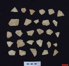
Figure
4.3 Whitish Chalky Wares (Left) Coarse Pottery Shards with Incised Pattern
(Right) Identified in TP A1 at Site A |
|
By
comparing the artefacts with other findings in Hong Kong and Zhuhai, it was determined that the chalky ware with stamped
pattern and coarse pottery shards with incised pattern identified from L2 to L5
of TP A1, were from the Late Phase of the Middle Neolithic Age (some 4,900-5,600 years ago) ([31]).
The same kind of pottery shards and a broken polishing
stone adze were identified in TPs A2 and A3.
No
archaeological features were identified inside the other test pits.
Although
other test pits contained no prehistoric pottery shards, one of them, TP A5,
did contain a few hand-held sized pebbles. This finding indicated that the
pebbles were collected by ancient people and taken to this hill slope area for
some working purpose.
Summary
Based
on the findings above and evaluation of natural topography, character of
superficial deposit, micro-landscape, natural erosion, past land use and
disturbance of the area, it is believed that an archaeological deposit exists
between 0.4 m to 1.2 m below ground level between 16 mPD
and 28 mPD .
The horizontal extent of this deposit covers approximately 900 m2 as shown in Figure 4.4. A
summary of test pits findings are shown in Table
4.1.
Table
4.1 Summary of Test Pits Findings
of Site A
|
Test Pit |
Findings Result |
||
|
|
Prehistoric
Period (Late Phase of Middle Neolithic Age,
4900-5,600 years ago) |
Historic Period |
No
Finds |
|
TP A1 |
ü |
|
|
|
TP A2 |
ü |
|
|
|
TP A3 |
ü |
|
|
|
TP A4 |
|
|
ü |
|
TP A5 |
|
|
ü |
|
TP A6 |
|
|
ü |
|
TP A7 |
|
|
ü |
|
TP A8 |
|
|
ü |
|
TP A9 |
|
|
ü |
|
TP A10 |
|
|
ü |
|
TP A11 |
|
|
ü |
|
TP A12 |
|
|
ü |
Site
B is situated on the hill slope located south of the Detention Centre. The site is densely covered with trees and
shrubs. According to the review of old
aerial photos, most of the area was previously used as terraced cultivated
fields in the 1950s to 1970s.
An
archaeological survey of the site was previously conducted in 1983 when 12
trenches along a baseline on a gentle slope some 60 m from the
The
area has been cut and filled for the facilities of the Detention Centre. Thus, any surviving archaeological remains at
the area have been heavily disturbed or partially destroyed due to previous
earth works at the area.
Field Walking
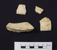
The
field walking identified two artefacts, a large stone saddle-quern and a quartz
disc, at a northwest facing slope at the elevation between 21mPD and 24 mPD.
The
large stone saddle-quern measured 58 cm in width, 90 cm in length and 8 cm in
height was made of sand stone. Both surfaces of the stone saddle-quern are
smooth and flat. Five circular and
smoothed areas with diameter range from 10 cm to 14 cm are identified on the
upper surface (see Figure 4.5).
These smoothed areas were formed due to grinding with pebble
grinders. The stone saddle-quern was
used for food preparation or polishing stone tools. The same kind of stone saddle-quern had been
discovered in an excavation pit at Shek Pik Tung Wan in 1989 ([34]).
The quartz disc measured 4.5 cm in diameter. It is white in colour and discovered in the
cut slope for a terraced field (see Figure
4.5).
This artefact is the waste/semi-finished material for quartz ring
production. No prehistoric pottery
shards were found from the field walking.
The result indicated high archaeological potential at the northwest slope
of Site B and thus, subsequent test pits were conducted.
|
|
|
|
Figure 4.5 Stone Saddle-quern (Left)
Quartz Disc (Right) Identified in Field walking at Site B |
|
Augering
Five
auger holes were bored at Site B (see Figure 4.6). No
cultural remains were found from the soil profiles of these auger holes. The details of auger hole
results are presented in Annex 12-C-A.
Test Pit Excavation
A
total of 16 test pits were excavated. The location of these pits focused on the
northwest slope of Area B, where previous archaeological investigation
previously took place. Prehistoric and
historic artefacts were identified in five of the pits: TPs
B1, B2, B3, B5 and B8 (see Figure 4.6).
The detailed findings for the test pits are presented in Annex 12-C-B. A summary of the findings from TPs B1, B2, B3, B5 and B8, where artefacts were found, is
as follows.
The
stratigraphy of the five test pits are similar, comprising a top soil
layer, subsoil layer and a weathered bed rock layer. The subsoil layer (colluvial
layer) is the layer where cultural layers occurred.
Based
on the soil texture and soil colour of TP B5, five strata were identified. The stratigraphic sequence was top soil layer (L1) →
subsoil layer (L2 to L4) → the regolith layer (L5). L4 is a coarse sand layer with some
gravel. In this layer were found some
quartz flakes, 2 quartz cores, 3 broken quartz rings, 11 quartz discs, 2
refitting pebble cores, 1 whetstone and some corded pot shards. Furthermore, 2
archaeological features were identified (see Section 5 for details).
Thus, this layer is defined as the cultural layer.
The
finds from TPs B1, B2, B3, B5 and B8 are classified
into two categories, artefacts and archaeological features. The artefacts are
prehistoric pottery shards, pebble grinder, whetstone, pebble hammer, quartz
flakes, quartz core, quartz discs, broken quartz rings. According to their typology and manufacturing
techniques and a comparison with same kind of finds in Hong Kong and the Pearl
River Delta, they date back to the early phase of the Late Neolithic Age some
3,500 to 4,400 years ago ([35]).
Three
archaeological features were discovered in two test pits, B1 and B5. One of the
features recorded as Feature 1 (F1) was identified in L4/F1 of TP B5. It consists
of a cluster of pebbles and cobbles, a few coarse ware shards, 1 broken quartz
ring, whetstone, 2 quartz cores and 1 quartz ring disc. At Feature F1 there
were two pieces of a broken pebble.
These pieces could be fitted together to form one large pebble though a
small part was missing (see Figure 4.7).
The position of this feature was close to another feature F2 of B5 (see Figure 4.7).
The
other feature (F2) comprised a cluster of 10 quartz ring discs behind a large
cobble in L4 of TP B5 (see Figure 4.7).
The discs were arranged in an orderly manner indicating that they are an
undisturbed in situ deposit.
The
third feature (F3) is a burial pit found in L2 of B1. It is a circular pit with
0.96 m diameter and a depth of 0.8 m. A brown
cracked glazed burial pot with two layers of lids was identified in the pit
(see Figure 4.8). A human skeleton was found in the
pot. Accordingly to the glaze and shape
of the pot, it dates from the late Ming to Middle Qing Dynasties (the 17th
to 18th centuries). This kind
of pot is seldom reported in published archaeological papers in Hong Kong and
Summary
Based
on the findings as mentioned above and evaluation of natural topography,
character of superficial deposit, micro-landscape, natural erosion, past land
use and disturbance of the area, it is believed that an archaeological deposit
occurs between 0.3 m and 0.8 m below ground level at between 17 mPD to 30 mPD at Site B. The horizontal extent covers approximately
800 m2 as shown in Figure 4.4. The summary of test pits findings are
shown in Table 4.2.
Table
4.2 Summary of Test Pits Findings
|
Test Pit |
|
Findings
Result |
|
|
|
Prehistoric
Age (Late Phase of Late Neolithic Age,
3,500 -4,400 years ago) |
Historic
Age (Late Ming to Middle Qing Dynasties, or
17th to 18th centuries) |
No
Finds |
|
TP B1 |
ü |
|
|
|
TP B2 |
ü |
ü |
|
|
TP B3 |
ü |
|
|
|
TP B4 |
|
|
ü |
|
TP B5 |
ü |
|
|
|
TP B6 |
|
|
ü |
|
TP B7 |
|
|
ü |
|
TP B8 |
ü |
|
|
|
TP B9 |
|
|
ü |
|
TP B10 |
|
|
ü |
|
TP B11 |
|
|
ü |
|
TP B12 |
|
|
ü |
|
TP B13 |
|
|
ü |
|
TP B14 |
|
|
ü |
|
TP B15 |
|
|
ü |
|
TP B16 |
|
|
ü |
Site
C is situated at the Detention Centre site.
Prior to the construction of the Detention Centre, the western portion
of this site was the location of a village known as Ha Tsuen
(
Late Neolithic Age to Bronze Age pottery shards had
been identified in this area in 2004.
However, the area has been heavily modified for the construction and
demolition of the Detention Centre during the late 1980s to the early
1990s. Thus, it is considered Site C has
high archaeological potential but has been severely disturbed by the
development of the Detention Centre.
Survey
Findings for 2004 Archaeological Investigation
During
the initial stages of this EIA, in August 2004, a preliminary archaeological investigation
was conducted at the preliminary proposed Project Area boundary (PPA) as shown
in Figure 2.1.
Field walking was undertaken on the
accessible hill areas and coastal area within the PPA. Only three historic period pottery shards were found on the surface of
hill slopes to the south and north of the Detention Centre. These finds were two Qing Dynasty
(A.D.1644-1911) pot and bowl shards collected on the south hill slope of the
Detention Centre between TP3 and TP4, and a Song to Yuan Dynasty (A.D.960-1368)
cracked celadon (a kind of light green glaze) bowl rim found besides a footpath
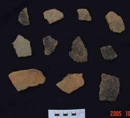
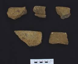
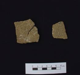
on the hill slope to the north of the Detention Centre (see Figure 4.9).
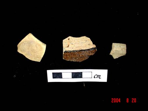
Figure 4.9 Song to Qing Dynasties Pot and Bowl Shards
Discovered at Both Hillslopes next to the Detention
Centre Site
Many shells were exposed on both hill slopes
to the north and south of the Detention Centre.
It is likely that the users of the Detention Centre left them
behind.
A total of 20 auger holes (AH) were bored
(see Figure 3.3 for
locations and detailed recording in Annex 12-C-C). The Detention Centre site is presently
covered with a concrete layer and is not suitable for hand augering. Consequently, augering
was undertaken on the two hill slopes to the north and south of the Detention
Centre. The findings indicated that the
topsoil layer consisted of brown sandy soil commonly found within the first
20cm from the ground, this soil profile regarded as O and A horizons. Beneath the topsoil layer is a yellowish
sandy soil layer on top of the bedrocks or its debris, this soil profile is a
subsoil layer regarded as B to C horizons.
Each auger hole had a diameter of approximately 10 cm and reached a
maximum depth of 0.2 to 1.3 m depth below the existing ground surface. The stratum of the soil and deposits were
recorded and are detailed in Annex 12-C-C.
No distinctive compact dark coloured stratum
(if this contains artefacts it is regarded as a cultural layer) was identified
from augering.
This suggests that no cultural layer exists at the hill slope
areas. All hand auger holes reached the
C horizon. No cultural layer or ancient
cultural remains were found in the auger holes.
Four test pits
(TP) were excavated within the PPA (see Figure
3.3). Detailed
strata descriptions on the TPs are presented in Annex
12-C-C.
Two test pits, TP1 and TP2, measuring 3 m x 3 m and 2 m x 3 m, both at an elevation of 6.71 mPD, were dug at the Detention Centre (see Figure 3.3). When correlated the stratigraphy between C/TP1 and C/TP2 at the Detention
Centre site, they are of almost the same stratum sequence as follows (see
details in Annex 12-C-C):
Concrete Floor® Filled soil ® Original topsoil layer ® Late Bronze Age Layer ® Late Neolithic Age Layer®Sterile Layer ® Bed Rock Textural Debris Layer.
In Layer 6 of C/TP2, regarded as Late Bronze
Age layer, artefacts such as a few pottery pot shards, hand-held size pebbles
and a pumice were revealed (see Figures 4.10, 4.11 and 4.12).
One of the shards was a typical datable
decoration pattern, an impressed “double f (kui
夔) ” pattern
(Figure 4.11). This pattern of pottery is commonly found in
Hong Kong and both
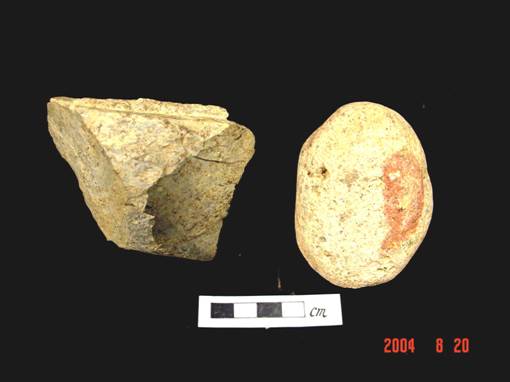
Figure 4.10 Hand-held Size Pebble and Working
Stone from C/TP2 L6
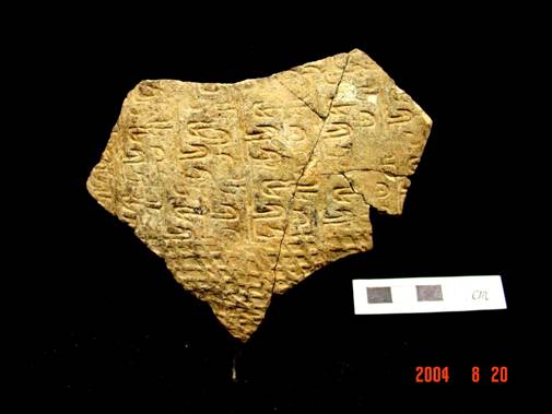
Figure 4.11 Double-f Pattern Pot Shard from C/TP2 L6
Figure 4.12 Coarse shards from C/TP6 L6
A piece of chalky pot shard without
decoration was unearthed in Layer 7 of C/TP2.
According to its texture, it is suggested that the shard is dated to
Late Neolithic Age ([36]).
According to the desktop review, it is
understood that C/TP1 and C/TP2 were excavated at the isthmus where the former
Ha Tsuen village was situated. The finds indicated that the isthmus area was
suitable for human habitation. A pumice (see Figure 4.13) is ancient environmental
evidence that was transported to the shore by sea waves, the discovery of
pumice and pebbles in Layer 6 in TP2 indicated that the layer was the original
ground level of some 3,000 years ago.
The recovery of the pottery shard with a decorated pattern double f commonly
found in Late Bronze Age pottery wares conforms with the “hard geometric”
pattern pottery identified from previous archaeological investigations since
1937. This result implies that there was
ancient human inhabitation on Tai A Chau since 3,000 years ago.
The result also suggests that at least one stable ancient cultural layer
from the Bronze Age still survives beneath the Detention Centre site at the
isthmus at an elevation of 4.7 mPD to 5.8 mPD (the existing ground level at the range of 6.7 mPD to 6.8 mPD).
Figure 4.13 Pumice
from C/TP6 L6
Two test pits, C/TP3 and C/TP4, measuring 1 m
x 1.5 m at elevation from 24.55 mPD to 25.39 mPD at the hill slope to the south of the Detention Centre
(see Figure 3.3). The strata of C/TP3 and C/TP4
are similar. The
ground surface is covered with shrubs and overgrown grass. Yellow red to reddish brown coarse sandy soil
were regarded as subsoil layers beneath the topsoil layer. Boulders measured as large as 70 cm in length
appeared throughout all layers, especially in subsoil layers both at C/TP3 and
Layer 4 in C/TP4. This suggested that
the strata are natural deposit without human disturbance. No artefacts of archaeological significance
were discovered in C/TP3 and C/TP4, which indicates no cultural layer (primary
deposit) on the southern slope of Detention Centre.
In
summary, two cultural layers dated to Late Neolithic
and Bronze Ages were identified as surviving beneath the
concrete layer of the Detention Centre at the original isthmus between Sai Wan and Tung Wan on Tai A Chau. It is believed that the original isthmus area
is at an elevation between 4.67 mPD and 5.8 mPD covered by the concrete platform (see Figure
4.14)
Survey
Findings for 2005 Archaeological Investigation
Based
on the 2004 findings result, further archaeological investigation was
undertaken in 2005 focus on test pitting to define the horizontal extent of the
deposits.
As
Site C had been heavily modified by previous site formation works and covered
with concrete, no fieldwalking and augering was undertaken.
Test pit allocation was based on the analysis of 1960s to the 1990s
aerial photos and old maps to establish the original landform to demarcate
possible extent of the original isthmus.
A
total of 6 additional test pits were excavated (see Figure 4.15) adjacent to the possible original
boundary of the isthmus to confirm the deposit boundary (see Figure 4.14). The deepest pit was excavated down to
3.5m below ground level. Details of the
test pit results are presented in Annex
12-C-B. Summary of test pit findings
are described below.
The
stratigraphic sequence of TP C6 consists of a surface
concrete floor (L1)→ filled soil layer (L2 to L7)→ first phase
Detention Centre concrete floor (L8, approximately dated to 1988)→filled
soil layer (L9)→original village concrete floor (L10, approximately
1970s) →isthmus sandy soil (L11-14).
The
test pit was dug to the L11 layer and the sequence below this level was
determined by boring an auger hole down to a depth of 1.5 m that reached +1 mPD. No artefacts
were found in any of the layers of the test pit.
The
first phase Detention Centre concrete floor was found in the stratigraphic profile of all other pits except TP C3. In TP C3, granite bedrock was found beneath
first Detention Centre concrete floor layer.
Although
TPs C1 and C4 were not excavated as deep as C6, the stratigraphy of these test pits was similar. This indicated that TPs
C1, C4 and C6 have the same geological layers.
The findings supported the desktop review and confirmed that the area at
TPs C1, C4 and C6 is outside the western boundary of
the archaeological deposit area.
No
cultural deposits were yielded from TP C2.
This result indicates that the archaeological deposits did not extend as
far as this test pit’s location. TP C2 is outside the northern boundary of the
archaeological deposit area. Similarly,
no cultural layers were identified in TPs C3 and C5.
This indicates these test pits are located to the east of the archaeological
deposit boundary.
Summary
Based
on the findings of the surveys undertaken in both 2004 and 2005 and evaluation
of natural topography, character of superficial deposit, micro-landscape,
natural erosion, past land use and disturbance of the area, the extent of the
Site C archaeological deposit has been demarcated. The findings from this excavation provide
further support and confirmation of the extent of the archaeological deposits,
which is shown in Figure 4.4.
The archaeological deposits cover a total area of approximately 1,600 m2
(40 m x 40
m). Within this area, there is a core of
archaeological deposits, which is correlated to the original isthmus. With reference to the original isthmus and
elevation, the core of the archaeological deposits is estimated to be 800 m2
(20 m x 40
m). The summary
of test pits findings are presented in Table
4.3.
Table
4.3 Summary of Test Pits Findings
|
Test Pit |
|
Findings
Result |
|
|
|
Prehistoric Age |
Historic Age |
No Finds |
|
TP C1 |
|
|
ü |
|
TP C2 |
|
|
ü |
|
TP C3 |
|
|
ü |
|
TP C4 |
|
|
ü |
|
TP C5 |
|
|
ü |
|
TP C6 |
|
|
ü |
4.1.4
Site D
Site D is located on a natural coastal terrace on
the northern side of the east bay, Tung Wan.
Prior to development of the Detention Centre, the adjacent shore was a
sandy beach. Currently, the shore consists of a granite block artificial
seawall. No archaeological survey has previously been undertaken in this
area. This site was investigated because
it was considered that the original topography of this coast may have been a
suitable location for human activities.
Thus, it is considered to have archaeological potential.
Field
walking
Field
walking was conducted at the terrace and along the existing footpath onto the
steep hill slope area at the back of the terrace. No finds were identified.
Augering
Six
auger holes were bored at the terrace area (see Figure 4.16).
Auger holes D/AH 5 and D/AH6 which were bored on the terrace revealed a
dark brown stratum composed of sandy soil.
No artefacts were identified from the two auger holes on the terrace or
from auger holes made on the adjoining slope.
Nevertheless, it was noted that the dark brown layer found on the
terrace is identical to the dark brown layer of TP D1 where cultural remains
were identified. This assisted in defining the horizontal extent of the
archaeological deposit. Details of the
auger hole results are presented in Annex 12-C-A.
Test Pit Excavation
Three TPs, test pits D1, D2 and D3, were excavated
at Site D (see Figure 4.16). Details of the test pits results are
presented in Annex 12-C-B. A summary of test pit findings are described
below.
Of
the three test pits, artefacts were found only in one, TP D1. The surface
layers of TP D1 (L1 and L2) consisted of filled soil, mixed with modern
construction waste and rubbish. Below
these, layers L3 and L4 are regarding as a natural stratum. Artefacts were found in the deeper L5 layer,
which consisted of dark brown sandy soil. In this layer were found historic and
prehistoric artefacts. These included
remains from lime kiln structures artefacts dated to Tang Dynasty (A.D.
618-907), celadon bowl shards dated to Song Dynasty (A.D. 960-1279) and a lot
of coarse corded pot shards and rims, chalky geometric pattern pot shards, and
stone tools (scraper, flake-knife) and a lot of flakes (see Figures 4.17 and 4.18). According to the
pottery fabric and its decoration patterns, they date back to the Late
Neolithic (3,500 to 4,400 years ago) and Bronze Ages (2,800 to 3,500 years ago)
([37]).
|
|
|
|
Figure
4.17 Corded Pottery Rim (Left) Stone
flakes (Right) Identified in L5 of TP D1 at Site D |
|
|
|
|
|
Figure 4.18
Flake-Knife (Left), Geometric Pattern Pottery Shards (Right)
Identified in L5 of TPD1 |
|
Summary
The
findings indicated that archaeological deposits at Site D occur some 0.8 m to
1.3 m below ground level at approximately 8 mPD. In addition to the evaluation of natural
topography, character of superficial deposit, micro-landscape, natural erosion,
past land use and disturbance from the construction and decommissioning of the
Detention Centre at Site D, it is believed that the horizontal extent of the
archaeological deposits cover an area
of approximately 100 m2
(20 m x 5
m) as shown in Figure 4.4.
A summary of test pit findings is presented in Table 4.4.
Table
4.4 Summary of Test Pits Findings
|
Test Pit |
|
Findings Result |
|
|
|
Prehistoric Age (Late
Neolithic Age to Early Bronze Ages, 2,800 to 4,400years ago) |
Historic Age (Tang
and Song Dynasties, A.D. 608-1279) |
No Finds |
|
TP
D1 |
ü |
ü |
|
|
TP
D2 |
|
|
ü |
|
TP
D3 |
|
|
ü |
4.1.5
Site E
Area E is situated at the eastern part of Tai A Chau. It comprises a slope area, a small valley with
a north running stream, terraced fields and a sandy raised beach facing
northeast. According to local people,
the bay is known as San Shek Wan (散石灣). A graveyard is located on the hill slope
area. According to the inscription texts
of grave headstones, the place is known as Ditangju (地塘咀). The area was previously surveyed by an
archaeological team from
Desktop review indicated that the area presently
occupied by abandoned terrace fields and the gentle slope area of the valley
were suitable locations for ancient activities.
Thus, it is considered to have archaeological potential.
Field
Walking
Field walking was conducted across the terraced
fields and gentle slope areas. Due to dense vegetation cover, no artefacts were
identified.
Augering
A total of 15 auger holes were made in the valley
and slope area (see Figure
4.19). The soil
profile at the valley bottom comprised dark grey mud indicated that this area
is a wetland. The soil profile from the
slope area consisted of dark brown to yellow sandy soil and loamy soil which is
indicative of colluvial soil. In addition, a layer of modern construction
waste was identified at the terrace area at the southern part of Site E. No artefacts were identified from the augering. Details of the augering
results are presented in Annex 12-C-A.
Test Pit
Excavation
A total of 17 test pits were excavated in various
landform areas. Prehistoric and historic artefacts and ecofacts
were discovered in 3 of the 16 test pits.
There are four landforms at Area E, comprising the
raised beach (sand dune), hill slope, coastal terraces and valley. In order to verify archaeological potential,
test pits were allocated to different landforms. TP E1 is located at the raised beach and TPs E2, E3, E4, E16 and E17 are allocated at the coastal
terraces. In the same way, TPs E5, E11 to E15 is located at the hill slope terrace, TPs E7 to E9 at the hill slope and TPs
E6 and E10 at the valley. Details of the test pit results are
presented in Annex 12-C-B. A summary of test pit findings are described
below.
TP E1 was excavated at a raised beach with an
elevation of 5.6 mPD (see Figure
4.19). Based on the soil texture and colour, the stratigraphy was divided into six layers, L1 is a top soil
layer, L2 to L5 is sand layer and L6 is a cobble layer.
A large quantity of ecofacts
(including shells, fish crania, fish jawbone, mammal tooth and animal bones)
and artefacts (pot shards, stone flakes, flake-knife, broken blades, scraper
and fired clays) were discovered in L3.
This layer comprises dark yellow coarse sand. Since ecofacts
associated with artefacts were found but no structural remains such as house
floor or post holes were found, it is believed that TP E1 is a dumping area
which should not be far away from the living area, probably on the hill slope
terrace.
A total of 1,803 shells were found in L3 of E1. The
shells mainly came from the marine snails Nerita albicilla, Monodonta
labio, Chlorostoma argyrostoma, Thais
luteostoma, and the limpet Cellana grata.
In addition, there are 206 fish bones identified and one of the species
identified is Pomadasys hasta (head
grunt) (see Figures 4.20 and 4.21) ([39]) .
A modern construction waste layer was identified in
both TPs E16 and E17 on the coastal terrace. This layer of dumped rubbish is solid
evidence that the original ground surface soil or even the subsurface soil had
been modified or disturbed.
|
|
|
|
Figure 4.20
Fish Bones (Left) Head Grunt Head Bones (Right) Identified in L3 of TP E1 at Site E
|
|
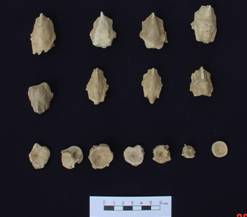
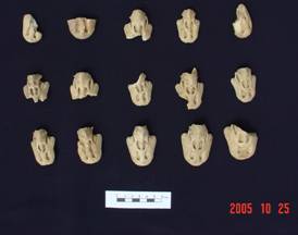
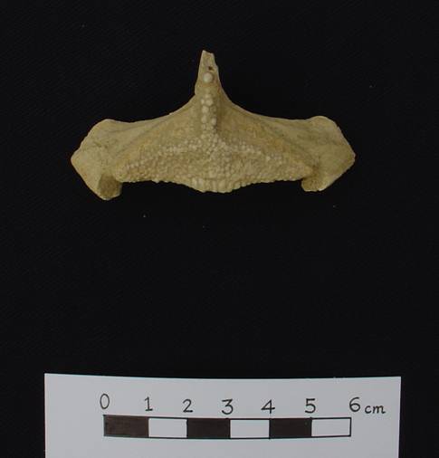
Figure 4.21 Fish (Grunt) Identified in L3 of TP E1
at Site E
Pottery artefacts found at TP E1 included 150 pot shards,
corded coarse ware pot shards and some shards with raised square and triangle
patterns (one kind of geometric design) impressed on the exterior (see Figure 4.22). Based on the decoration pattern and shards
fabric, L3 of TP E1 is dated to the Bronze Age (about 2,400 to 3,500 years
ago), also known as the Middle to Late Western Zhou to Spring
and Autumn Periods in
Figure
TP E2 is located at the coastal terrace area. The stratigraphy is
that L1 is the topsoil, L2 and L3 are subsoil and L4 is weathered bed
rock. A Song Dynasty celadon bowl shard and a rim were
identified in L2 and L3.
TPs E5 to E9 were
dug on terraces and hill slopes on the west side of the valley. The stratigraphic
sequence of these test pits are almost the same, comprising top soil subsoil
and then weathered bed rock layer.
No artefacts
were found in TPs E3 to E7 and TPs
E9 and E10. A piece of prehistoric
coarse ware shard was found in L2 of TP E8 indicating that archaeological
potential exists at the western gentle slope area at Site E.
TPs E6 and E10
were dug on the northern end of the valley in Site E. The E6 test pit located
on the hill slope was observed to be composed of colluvial
deposit. Dark grey mud was observed in
TP E10.
TPs E11 to E15
were excavated at the slope area, while TPs E16 and
E17 were excavated at a coastal terrace at the southern part of Site E. No artefacts or archaeological feature were
discovered in these test pits. These
test pits were composed of colluvial soil. In addition, a layer of modern construction
waste was observed in TPs E16 and 17, which indicated
that the terrace area had been used as a rubbish dump.
Summary
The
findings indicated that three archaeological deposit areas were identified in
Site E. One of these is located at the
raised beach area, while the others are located at the coastal terrace and
valley gentle slope. To demarcate the
archaeological deposit area of Site E, the natural topography, character of
superficial deposit, micro-landscape, natural erosion, past land use and
disturbance of the area was evaluated.
The evaluation concluded that the extent of the archaeological deposit
is 8 m x 10 m at the raised beach area, 25 m x 10 m at the coastal terrace and
8 m x 15 m at the gentle slope.
The
archaeological deposits are located 0.4 m to 0.9 m below ground level at both
the raised beach and coastal terrace areas and 0.3 to 0.5 m below ground level
at the gentle slope area. The
archaeological deposits cover areas of approximately 80 m2
at E1, 250 m2 at E2 and 120 m2 at E3 respectively as shown in Figure 4.4.
The summary of test pits findings are presented in Table 4.5.
Table
4.5 Summary of Test Pits Findings
|
Test Pit |
Findings Result |
||
|
|
Prehistoric
Age Late Neolithic Age to Bronze Age (2,250 to 4,000 years ago) |
Historic
Age Song Dynasty (A.D. 960-1279.) and late Qing Dynasty |
No
Finds |
|
TP E1 |
ü |
|
|
|
TP E2 |
|
ü |
|
|
TP E3 |
|
|
ü |
|
TP E4 |
|
|
ü |
|
TP E5 |
|
|
ü |
|
TP E6 |
|
|
ü |
|
TP E7 |
|
|
ü |
|
TP E8 |
ü |
|
|
|
TP E9 |
|
|
ü |
|
TP E10 |
|
|
ü |
|
TP E11 |
|
|
ü |
|
TP E12 |
|
|
ü |
|
TP E13 |
|
|
ü |
|
TP E14 |
|
|
ü |
|
TP E15 |
|
|
ü |
|
TP E16 |
|
|
ü |
|
TP E17 |
|
|
ü |
Site
G is located next to a bay (Pak Tso Wan) to the
northwest of Nam Shan (see Figure 4.4).
The site is mainly covered with trees and shrubs. Previous archaeological investigation had
been conducted in the 1990s at this area but nothing was found.
There
are four types of natural sediment deposits in the valley. The modern sand
dunes consist of fine sand. The wet
agricultural land consists of grey mud and whitish and yellowish fine sand. The
lower valley is composed of dark grey mud and upper valley has deposits of
brown to yellow colluvial soil.
Field Walking
Field
walking was undertaken on the beach, abandoned fields and the valley. Due to
dense vegetation cover, no artefacts were identified from field walking.
Augering
A
total of 4 auger holes were bored within Site G (see Figure 4.23).
Although no cultural remains were identified from augering
(see Annex 12-C-A for details),
Bronze Age shards had been revealed at the interface between Layers 3 and 4 of
TP G2. As there is a correlation of stratigraphy between AH G1 and TP G2 (AH G1 is located 12 m
north of TP G2), this indicated that AH G1 is in an area of archaeological
potential and that the archaeological remains covers area where AH G1 located.
Test Pit Excavation
A
total of 3 test pits were excavated at Site G (see Figure 4.23).
Two of the test pits (TP G1 and G2) were allocated to the lower valley
with alluvial sediment The other test pit (TP G3) was
dug at the upper valley. This allowed
differences in the stratigraphy of the test pits
located in the upper and lower valley to be identified.
The
stratigraphic sequence of TPs
G1 and G2 in the lower valley area is top soil layer →grey sand and dark
bluish gray → yellow sand→cobble layer.
This stratigraphy was indicative of the existence of
a past lacustrine (lagoon) environment. Some
artefacts dated to Bronze Age and Song and Yuan Dynasties (A.D. 960-1368) were
found in test pit TP G2. The presence of these ancient artefacts which were
deposited in lagoon sediments as well as their eroded rounded edges suggests
that they were washed down from the slope nearby or from the flat area of upper
valley. The stratigraphy
of TP G3 at the upper valley is top soil→subsoil
layers →regolith layer. (see
Annex 12-C-B for details)
Artefacts
comprising pottery shards and a stone tool were discovered in only one of the
three test pits excavated, namely TP G2, which was excavated in the lower valley
at an elevation of 4.63 mPD. In this pit, pottery was found at the
interface between two strata, L3 and L4.
The pottery artefacts consisted of 1 piece of light green crackled
glazed rim shard, 1 piece of dot with square pattern of coarse sand shard, 2
pieces of plain whitish chalky shards and 2 pieces of corded as well as 57
plain coarse ware shards (5 pieces of pot rim).
Based on the glaze character of the shards, they date back to the Song
to Yuan Dynasties and Bronze Age. A
stone chopping tool made of coarse tuff was also discovered amongst the Bronze
Age pottery shards at the interface between L3 and L4 of TP G2.
Summary
Based
on the fieldwork findings, archaeological deposits occur in the lower valley
area of Site G as shown in Figure 4.4.
At the lower valley, archaeological deposit is present between 0.3m and
0.6m below ground level. The artefacts
that were found were located in the stratum consisting of alluvial grey and
yellow sand. The pottery shards were
observed have rounded edges, which indicates that these artefacts are a
secondary deposit. With reference to the drainage pattern of the area, the
primary deposit is located further up the slope at the upper valley higher than
the Site G known archaeological deposit area.
To
demarcate the archaeological deposit area of Site G, the natural topography,
character of superficial deposit, micro-landscape, natural erosion, past land
use and disturbance of the area had been evaluated, it is believed that there
are archaeological deposits that cover areas beyond where TPG2 and AH G1 are
located. It is estimated that the
archaeological potential area covers approximately 600 m2
(see Figure 4.4).
The
summary of test pits findings is presented in Table 4.6.
Table
4.6 Summary of Test Pits Findings
at Site G
|
Test Pit |
|
Findings
Result |
|
|
|
Prehistoric
Age (Bronze Age, 2,300 B.C. to 250B.C.) |
Historic
Period Song and Yuan Dynasties (A.D.960-1368) |
No
Finds |
|
TP G1 |
|
|
ü |
|
TP G2 |
ü |
ü |
|
|
TP G3 |
|
|
ü |
4.3
Shek Pik
The
Site (Site F) is situated on an area spanning low terrain and adjoining lower
hill slopes close to the coast from the east to the north side of the bay
called Tung Wan at Shek Pik
on
Field Walking
The
ground surface within the Shek Pik
Tung Wan Archaeological Site is currently filled with a layer of over 1m of
1970s rubbish. A few lime kiln
structures remain, such as broken bricks and fired bars which were identified
in an area next to an electric post (see Figure
4.25).
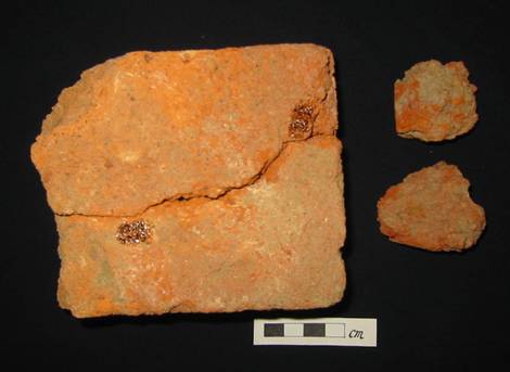
Figure 4.25 Lime Kiln Structure Remains Identified
from Field Walking at Shek Pik
Augering
A
total of 19 auger holes were bored within the Shek Pik Study Area (see Figure 4.26).
Nine of the auger holes were located on the low terrain on the east side
of Tung Wan. Four others were bored in
the vicinity of the rock carving (a declared monument) and the remaining six
were bored to the south of the Country Park Office close to the coast on the
north side of the bay. No cultural
remains were found during the augering (see Annex 12-C-A for details).
Test Pit
A
total of seven test pits were excavated in the Shek Pik Study Area. Five
of these were excavated on the low coastal area on the eastern side Tung Wan
bay, while the other two were excavated in an area to the south of the Country
Park Office on the northern edge of Tung Wan bay (see Figure 4.26).
Of the five test pits dug on the east side of Tung Wan, three (SP1, SP3
and SP5) were located on the raised beach, while the other two (SP 2 and SP4)
were located on the adjacent hill slope area.
In this way, the test pits encompassed areas with different stratigraphies arising due to different landforms at the
site.
It
was found that the stratigraphic sequence in test
pits located on the hillslope area goes from top soil
layer to subsoil layer and subsequently down to a regolith
layer (weathered bed rock layer). In
contrast, the stratigraphy of test pits located on
the raised beach is topsoil→sand layer →cobble
layer.
In
terms of archaeological finds, ancient artefacts were only found in two of the
five excavated test pits. The test pits with artefacts were TP SP1 and TP SP4.
Excavations
for TP SP1 were carried out on the raised beach at an elevation of 7.4 mPD. The pit was
excavated to 5.3 mPD, which was close to the bottom
level of the test pit excavated in 1979, 1987, 1988 and 1989 by the Hong Kong
Archaeological Society and The Chinese University of
The
stratigraphy of TP SP1 was composed of 6 layers.
Layers 1 to 4 of SP1 mainly comprise sandy soil and some waste material, which
indicate that these layers have been disturbed by previous activities. Lime kiln structure remains such as broken
bricks were found in L3 that dates back to the Tang Dynasty
Pebbles
identified in L4 and a stone flake with a few striking scars were identified in
L5 with compacted dark yellow coarse soil.
The stratigraphic sequence of the survey’s
test pits was found to correlate with previous 1987-1988 excavations([40]) ([41]) ([42]). The comparison indicated that Layer 5 of
SP1 is identical to Layer 9 of the 1988 -1989 excavations.
According to absolute dating results, this Layer 9 was deposited between
BC3,200 to BC3,785([43]). Artefacts in L4 and L5 are therefore
considered to be from the Late Neolithic Age. Below this layer, L6 comprises a
cobble layer from which no artefacts were found.
The
other test pit which contained artefacts was TP SP4, located at the foothill
slope on the east side of Tung Wan bay.
The stratigraphic sequence of SP4 was top soil
(layer L1) → subsoil of yellow coarse sandy soil (layer L2) → regolith (layer L3) of whitish to yellow weathered bedrock
texture soil. A small piece of coarse ware shard was found at L2. Based on its fabric, the shard was dated to
the Late Neolithic Age some 4,000 years ago.
Summary
Taking
into account the survey findings and a review of previous archaeological findings
from this area, it is considered that archaeological deposits occur at the
raised beach area and the gentle hill slope area as shown in Figure 4.27.
To demarcate the archaeological deposit area of Shek
Pik (Site F), natural topography, character of
superficial sediment, micro-landscape, and disturbance of past land use were
not only taken into account, but also correlation of test pits and augers hole
soil profile and referred to pervious archaeological surveys, these
archaeological deposit of Shek Pik
cover an area of approximately 1,500 m2.
At the hill slope area, archaeological deposits exist between 0.4m to
0.7m below ground surface at an elevation of 9 mPD to
13 mPD. At the
raised beach area, archaeological deposits exist between 0.5 m to 2.3 m below a
ground level of 7.4 mPD. A summary of the test pits findings is
presented in Table 4.6.
Table
4.6 Summary of Test Pits Findings
in Shek Pik
|
Test Pit |
Prehistoric
Age (Late
Neolithic Age, 4,000-3,400 years ago)
|
Findings
Result Historic
Period |
No Finds |
|
TP SP1 |
ü |
|
|
|
TP SP2 |
|
|
ü |
|
TP SP3 |
|
|
ü |
|
TP SP4 |
ü |
|
|
|
TP SP5 |
|
|
ü |
|
TP SP6 |
|
|
ü |
|
TP SP7 |
|
|
ü |
5
Preliminary
Finds Assessment
5.1
5.1.1
Artefacts and Ecofacts
The
artefacts unearthed at
Table 5.1 Summary
of Artefact and Ecofacts Found for the Surveys Understaken between 2004 and 2006
|
Test Pits |
Layer |
Pre-historic pottery |
Stone tool |
Stone flake & core |
Quartz ring |
Quartz disc |
Song celadon |
Blue and White Porcelain |
Modern depsoit |
Ecofact |
|
C/ TP2 |
L6 |
1(dof) |
Some pebbles |
|
|
|
|
|
|
|
|
|
L7 |
1(ch) |
|
|
|
|
|
|
|
|
|
A1 |
L2 |
6(cor) |
|
|
|
|
|
|
|
|
|
|
L3 |
42(ch), 21(cor) |
1(h), 3(pe) |
8(f) |
|
|
|
|
|
|
|
|
L4 |
22(cor), 16(ch) |
1(h), 2(g), 3 (pit) |
1(f) |
|
|
|
|
|
|
|
|
L5 |
106(ch), 83(cor) |
4(0), 1(u) |
|
|
|
|
|
|
|
|
A2 |
L2 |
36(cor), 2(ch) |
1(g) |
1(f) |
|
|
|
|
|
|
|
A3 |
L2 |
50(cor) |
1(g), 1(ad), 2(u) |
1 (f) |
|
|
|
|
|
|
|
B1 |
L2 |
4(cor) |
|
3(f) |
|
|
|
|
|
|
|
|
L3 |
1(cor) |
1(u) |
2(f), 4 (r ) |
|
|
|
|
|
|
|
B2 |
L3 |
|
|
1(f), 1(c) |
|
|
|
|
|
|
|
B5 |
L3 |
33(cor) |
|
7(f) |
|
|
|
|
|
|
|
|
L4 |
57(cor), 7(ch) |
4(u), 3(g), |
7(f), 6 (c ) |
1 |
10 |
|
|
|
|
|
B8 |
L2 |
|
|
|
1 |
|
|
|
10 |
|
|
B12 |
L2 |
|
|
|
|
|
|
|
|
|
|
C6 |
L9 |
|
|
|
|
|
|
7 |
21 |
4(sh) |
|
D1 |
L5 |
84(cor), 12(geo) |
1(kn) |
13 (r ) |
|
|
|
|
|
4(sh) |
|
E1 |
L1 |
2(cor), |
|
|
|
|
|
1 |
|
|
|
|
L2 |
1(cor) |
|
|
|
|
|
|
|
|
|
|
L3 |
23(cor), 117(geo) |
2(u) |
87(r ), 9(f) |
|
|
|
|
|
1(te), 79(b), 1803 (sh) |
|
E2 |
L2 |
|
|
|
|
|
2 |
|
1(p), 15(rf) |
|
|
|
L3 |
|
1(g) |
|
|
|
1 |
|
2(rf) |
|
|
E4 |
L1 |
|
|
|
|
|
|
|
6 |
|
|
E7 |
L1 |
1(cor) |
|
|
|
|
|
|
|
|
|
E8 |
L1 |
|
|
|
|
|
|
|
4 |
|
|
G2 |
L2 |
59(cor), 2(ch), 1(geo) |
|
1(cho) |
|
|
1 |
|
|
|
Note: ad=adze, b=bone, c=core,
ch=chalky shard, cho=chopping
tool, cor=coarse shard, dof=double
f pattern shard, f=flake, g=grinding stone and whet stone, geo=geometric shard,
h=hammer , kn=knife, p=pounder, pit=pitted pebble, pe=pebble,
r=stone raw material, sh=shell, te=animal
tooth, u=function unclassified.
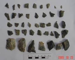
5.1.2
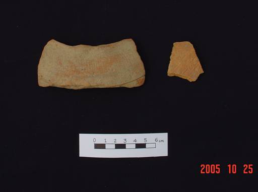
Pottery
A total of 783 prehistoric pottery shards and 4 Song Dynasty celadon
bowl shards were found in
Table 5.2 Pottery
Shards found on
|
Period |
Middle Neolithic Age |
Late Neolithic Age |
Bronze Age |
Song Dynasty |
Late Ming to Late Qing Dynasty |
|||
|
|
4,000 B.C.– 2,500 B.C. |
2,500 B.C.– 1,500 B.C. |
1,2000 B.C.– 220 B.C. |
A.D. 608 – 1911 |
||||
|
Pottery Type |
Plain Whitish Chalky Shards |
Incised and plain Reddish Chalky Shards |
Corded and Incised Coarse Ware Shards |
Coarse Corded Ware Shards and Chalky Shards |
Geometric, Plain, Double-f Pattern,
Corded ,Coarse Shards and Plain Chalky shards |
Hard Geometric Shards |
Celadon Bowl Shards |
Blue-and white Porcelain bowl shards and dark brown glazed shards |
|
Site
A |
160 |
6 |
218 |
|
|
|
|
|
|
B |
|
|
|
102 |
|
|
|
2 |
|
C |
|
|
|
|
2 |
|
|
28 |
|
D |
|
|
|
78 |
12 |
1 |
2 |
16 |
|
E |
|
|
|
27 |
117 |
|
|
6 |
|
G |
|
|
|
|
61 |
|
1 |
|
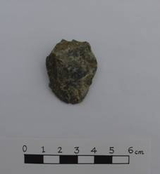
Coarse Ware Shards
The coarse ware shards were dated to the Late Phase of the Middle Neolithic,
Late Neolithic and Bronze Ages. A total
of 218 coarse ware shards were found in three TPs: TP
A1, A2 and A3 at Site A. The majority of
the shards have corded and incised wave patterns on their surface (see Figure 5.1). In addition, a few shards have incised wave
designs both on the upper neck and interior surface of the rim or incising
horizontal lines over the corded pattern.
This is a typical design of globular pot dated to the Late Phase of
Middle Neolithic Age. Elsewhere in Hong
Kong, the same kind of finds have previously been unearthed at the Sham Wan
Site on
Figure 5.1 Corded Pattern Coarse
Ware Shards Identified in TPA1
In test pits B1 and B5 at Site B, a total of 95 coarse ware shards,
which have an impressed corded or plain pattern were found. At Site D, 84 coarse ware shards with a
corded pattern were found in test pit D1.
The shards from these two sites were dated to the Late Neolithic Age
(some 3,400-4,000 years ago) (see Figure
5.2).
Figure 5.2 Corded Pattern
Coarse Ware Rim Shards Identified in L5 of TP D1
At Site G, a total of 59 coarse ware shards were found in TP G2. The majority of these have corded patterns
(see Figure
5.3(a),
lower row, right and left), while some were plain with no decoration. One of the coarse ware shards, which was found in the same layer as the others, has a dotted
square pattern (see Figure 5.3(a),
lower row, middle). This indicates
that the layer where coarse ware shards were found dates to the Bronze
Age.
Geometric Design Coarse Ware Shards
Coarse ware shards with geometric design patterns occurred at two sites,
Sites E and G. In total, 118 pieces of
geometric design coarse ware shards were unearthed in TP E1 of Site E (see Figure 5.4). Elsewhere in
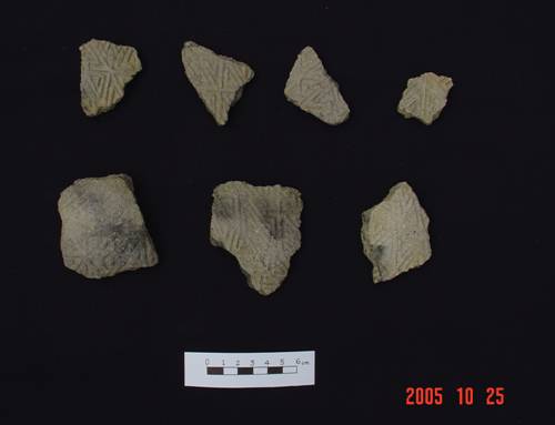
Figure 5.4 Geometric Design Coarse
Ware Shards Identified in L3 of TP E1
As mentioned previously, at Site G, a single shard piece was impressed
with dots in square pattern. This is a
typical design of globular pots (see Figure 5.3(a),
lower row, middle) in the Bronze Age (Middle to
Late Zhou Dynasty to Autumn and Spring Period) in the
Chalky Ware shards
Chalky ware shards were unearthed at Sites A and G at
At Site A, 160 whitish and 6 reddish shards were found in three strata
(L3, L4 and L5) of TP A1. The chalky
ware shards were determined as being pottery shards and basin shards with a
foot ring. In terms of decoration, the
vast majority of the whitish shards and all the reddish shards are plain.
However, a small number of the whitish shards from the foot ring were decorated
and perforated (see Figure 5.5). The
incised design on these shards, which consists of concentric circles and arc
pattern (see Figure 5.5) is typical of the Late Phase of
the Middle Neolithic Age in
|
|
|
|
|
Figure 5.5
Incised Chalky Wares (Left)Chalky Basin Foot Ring Shards (Right)
Identified in TPA1 at Site A |
|
||
Similar incised chalky and incised corded shards have previously been found
elsewhere in Hong Kong such as at Fu Tei on Chek Lap Kok island ([50]) as well as at the Caotangwan
(草堂灣) site of Sanzao (三灶) Island
in Zhuihai City ([51]) in China. Using Carbon-14 dating
techniques, the finds from Chek Lap Kok, were dated to between 3,355B.C. to
3,890B.C. and 3,650B.C. to
4,100B.C. ([52]).
Both the original Fu Tei site, which no longer
exists, and Site A of South Soko
Island are situated at similar topography at a narrow terrace at an elevation
of 12 mPD to 18 mPD facing
the sea.
At Site G, two plain undecorated whitish chalky ware shards were
unearthed. (see Figure 5.3(a),
upper row). These shards were found in the interface between L3 and L4 of
TP G2. Based on the presence of other pottery shards dated to the Bronze Age in
this layer, the chalky shards were also determined as belonging to the Bronze
Age.
Hard Chalky Shards
At Site E, a single piece of impressed raised square design as well as a
single piece of net design pot shards were found at L3 of TP E1 (see Figure 5.6). The layer where these two shards were found
also contained coarse shards that were decorated with a triangular geometric
pattern. The raised square design is
typical of Bronze Age pottery in
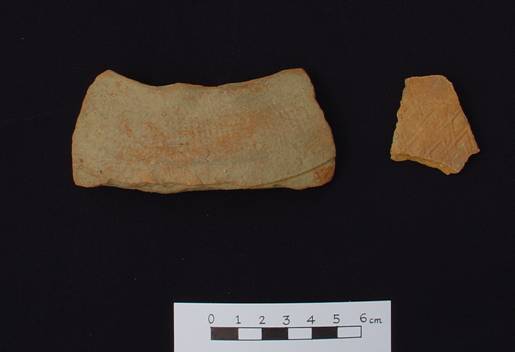
Figure
5.6 Net Design Pot Shards
(Left) Impressed Raised Square Design (Right) Found in L3 of TPE1 at Site E
The same kind of pot and gui (a kind of deep
circular vessel with handles) with raised square design was previously found at
Hengling shan (橫嶺山) cemetery in Baluo (博羅) in
Burial Urn with Two Lids
A burial urn with two layers of lids was found as an archaeological
feature, L2/F1 in TP B1 in Site B (see Figure
5.7). The height of the pot is 47
cm, the pot exterior surface is covered with brown cracked glaze and the style
of such glaze is the same as the those produced from Qishi (奇石) kilns
in
|
|
|
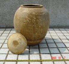
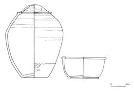
Figure
5.7 Burial Urn with the Inner Layer Lid
(Left) Drawing
of Burial Urn and the Outer Layer Lid (Right)
However,
according to personal communication with a
5.1.3
Porcelain
Celadon
Three celadon bowl rims (see Figure
5.8) were found in TP D1 of Site
D. Based on the glaze, it is classified
as Qingbin (青白) ware, which was
produced in
In addition, a piece of light green crackled glazed bowl shard was
discovered in Layer 3 of TP G2 at Site G, which was dated to the Song Dynasty
(see Figure 5.3(b)).
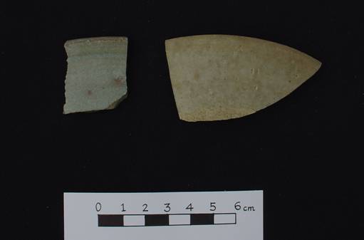
Figure
5.8 Celadon Shards Identified in L2 of D1
Blue-and-White Porcelain
Blue-and
white porcelain shards were found in TP C6 of Site C, D1 of Site D and E1 of Site
E (see Figure 5.9). By comparing these finds to the same kind of
finds in
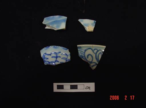
Figure 5.9 Blue
and white Porcelain Shards Identified in TPC6 of Site C
5.1.4
Stone Tools
The stone tools found in this survey were pebble tools, natural tools,
striking tools and polishing tools. The
pebble tools are handheld-sized pebbles used as tools. They include chopping
tools, hammers, pounders and grinders. Naturally occurring stones which were ready
for use and made of sandstone were chosen to be whetstones and saddle-quern
stone. Pebble stones were used for a
long period of time at coastal and riverside areas throughout the Neolithic Age
to Early Iron Age.
Chopping Tool
A stone chopping tool was unearthed at the interface between L3 and L4
of TP G2 at Site G. The chopping tool is
a heavy core tool and was presumably used for wood chopping. This chopping tool is made of whitish coarse
tuff. It is bifacially trimmed, with flakes removed
from both dorsal and ventral surfaces to form a sharp edge. It is 124 mm long with a height of 98mm. The
angle of its chopping edge is between 60 degrees and 70 degrees. A striking platform can also be discerned
(see Figure 5.10).
Pebble Tools
Most of the pebble tools were found in TPs A1,
A2 and A3 at Site A. There are 3
grinders found in TPs A1, A2 and A3 and 3 pebble
hammers found in TPs A1 and A3 (see Figure 5.11).
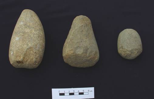
Figure
5.11 Pebble Pounders
in TPA1 at Site A
Whetstone
Two whetstones were unearthed in the test pits at
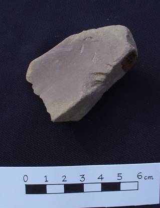
Figure
5.12 Whetstone
Found in L4 of TP B5 at Site B
Stone Saddle-quern
A
large stone saddle-quern made of sand stone was found on the slope of Site B
(see Figure 5.13), the length of the
stone is 90cm. It would have been used
for food processing or for stone tool polishing.
|
|
|
|
Figure 5.13 Photography and Drawing of Stone Saddle-quern |
|
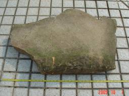
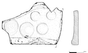
Scraper
A scraper (see Figures 5.14 and 5.15) made of dark grey tuff was
discovered in L3 of TP E1. The scraper is made of a stone flake. A notch can be identified on the left side of
the flake axis. The length of the
scraper is 5.1 cm and its thickness is 0.8 cm.
Some small, dark grey tuff flakes were also found associated with the
scraper.
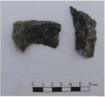
Figure
5.14 Scraper
(Left) and Awl (Right)
|
|
|
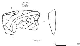
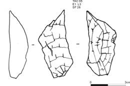
Figure
5.15 Drawings of Scraper
(Left) and Awl (Right)
Awl
An
awl made of dark grey tuff was found in L3 of TP E1. This artefact had been made of a blade with a
point and edge (see Figures 5.14 and 5.15).
A ridge can be identified from the dorsal surface which is formed by a
special technique to control the flaking.
The length of the awl (measured along the flake axis) is 5.1cm, the
width is 2.1cm and the thickness is 1.5cm (measured form diffuse bulb to height
point of the ridge of the dorsal surface).
Flake-knife
A flake-knife made of an ovoid shaped flake was found in L5 of TP D1 at
Site D. (see Figure 5.16). The rock used to make the knife is dark grey
tuff. The working edge and striking
platform can still be identified. No
traces of trimming can be observed but a few scars remained on both the ventral
and dorsal surfaces. The length of this
knife is 3.5 cm (measured along flake axis) and the width is 2.8 cm.
|
|
|
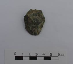
Figure 5.16 Flake-knife Identified in L5 of TP D1
Stone Adze
A
broken stone adze edge (see Figure 5.17)
was found in L2 of TP A3 at Site A. Both
sides of the adze surface were smoothly polished and wearing remains can still
be observed from the edges. The adze was
made of a dark green sedimentary stone.
Figure
5.17 Stone Adze Identified in L2 of A3
5.1.5
Stone Ornament
Quartz Ring
Two broken quartz rings (see Figure
5.18) were found at Site B. One
was in TPs B5 and one in B8. In TP B5, the ring was found in F2, close to
a quartz disc, a quartz core and a few quartz flakes. According to the section feature of the
rings, these rings belong to the first phase of ring production in Pearl River
Delta coastal areas([57]) dated to the Late
Neolithic Age. The same kind of artefact had been revealed on the same slope in 1983 ([58]).
Figure
5.18 Stone Core, Stone Disc, Broken
Stone Rings (from Left to Right), Reflecting the Process of Ring Manufacturing
5.1.6
Stone Ornament Raw Material and Production
Waste
Quartz Flake and Quartz Core
A few quartz flakes were found in L4 of TP B5. These were associated
with a broken quartz ring and quartz discs.
It is believed that these flakes were waste material from quartz ring
production. A quartz core was found in
the same stratum of the same pit. The
core is a raw material for quartz ring production (see Figure 5.19).
Quartz Disc
There were 12 quartz discs found in Site B. 11 discs were unearthed from L4 of TP B5 and
another one was identified from fieldwalking on a
slope some 13 m to the southwest of TP B5.
In TP B5, 10 quartz discs were orderly placed next to a boulder. This indicated that the cluster of disc is an
undisturbed in situ deposit (see Figure
4.7). These discs
are waste material from quartz ring manufacturing that can be reused to produce
more new quartz rings ([59]).
Thus, the discs were deliberately placed next to the boulder by ancient
people for storage to be collected and reused later. The diameter of these discs is in the range
of 3.1 cm to 5.0 cm, the thickness is in a range of 1.2 cm to 1.4 cm.
Figure
5.19 Quartz Discs Identified in F2/L4
of TP B5
Another quartz disc was picked up in a terrace field cut section (see Figure 4.5, right) and it is believed that it was washed down from the
upper slope.
By comparing the finds to those found at the Yung Long Site at Tuen Mun and Baojianwan
in Zhuhai City ([60]), it was determined that these finds date
back to the Late Phase of the Late Neolithic Age.
Since artefacts from different stages of quartz ring production were
found, it was considered that a quartz ring workshop site occurred on
5.1.7
Shells
A total of 1,803 shells were found in L3 of
TP E1 at Site E. They are classified
into 14 species by visual examination.
Based on a hard raised square pattern pot shard and some triangle
pattern pot shards associated with the shells, these shells are dated to Late
Bronze Age (2,500 to 3,000 years ago).
Some of the shells have burn marks which
reflected that they were collected for food consumption. Table
5.2 summarises the shell species identified and some representative
specimens are shown in Figure 5.20.
Table 5.3 Shell
Species and Quantity
|
Species |
Quantity |
Habitation
Area |
|
Nerita albicilla |
824 (45.7%) |
Rocky shore, lagoon |
|
Monodonta labio (Common Top Shell) |
279(15.47%) |
Rocky, cobble and pebble shore |
|
Cellana toreuma(Common Limpet) |
192(10.64%) |
Rocky shore |
|
Chlorostoma argyrostoma
(Orange Top Shell) |
159 (8.81%) |
Rocky and cobble, pebble shore |
|
Thais luteostoma (Yellow-mouthed
Whelk) |
104 (5.76%) |
Rocky shore |
|
Camaena cicatoricosa
(Large Striped Snail) |
98 (5.43%) |
|
|
Nerita costata |
45 (2.48%) |
Rocky shore |
|
Lunella coronata
(Common Turban Shell) |
40 (2.21%) |
Pebble shore and sandy shore |
|
Collisella sp. (Limpet) |
19 (1.05%) |
Rocky shore |
|
Collisella dorsuosa (Limpet) |
19 (1.05%) |
Rocky shore |
|
Chicoreus torrefactus (Common Murex) |
4 (2.2%) |
Rocky shore |
|
Cronia margariticola ( Small Blue Mouthed Whelk) |
2 (1.1%) |
|
|
Strombus Luhanus
(Blood-mouthed Stromb) |
2 (1.1%) |
Sandy and muddy shore |
|
Polynices melanostoma
(Blotched Moonshell) |
1 (0.55%) |
|
|
Unclassified |
15 (0.83%) |
|
|
|
Total 1,803 |
|
|
|
|
|
|
|
|
|
|
|
|
|
|
Figure
5.20 Shells Identified from L3 of TP
E1 at Site E |
|
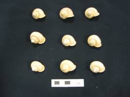
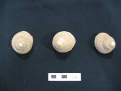
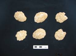
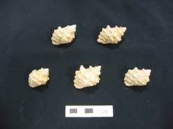
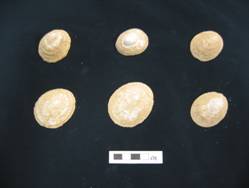
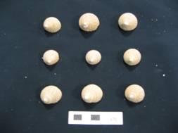
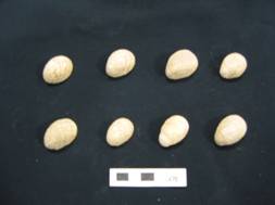
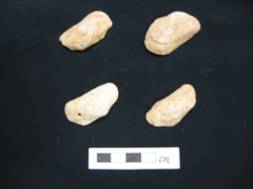
5.1.8
Fish Bones
There were 206 pieces of crania and two jawbones of Pomadasys hasta (head grunt)
identified in L3 of TP E1 at Site E. (see Figure
5.21). During spring and early summer, P. hasta
migrate shoreward to spawn, by which time they would have been readily
accessible in the shallow inshore water. Their spawning season corresponds with
the beginning and the initial peak period of the wet southwest monsoon
(June-July) ([61]).
|
|
|
|
Figure 5.21 Head Grunt Head Bones and Jaw Bone in L3
TP E1 at Site E |
|
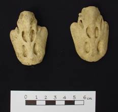
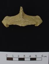
5.1.9
Animal Bone
There were 15 pieces of animal bones discovered from L3 of TP E1 and the
bones had been burned (see Figure 5.22). This indicates that area of E1 was used as
rubbish dump. According to the datable pottery
associated with the bones, they date back to Bronze Age, some 3,000 years ago.
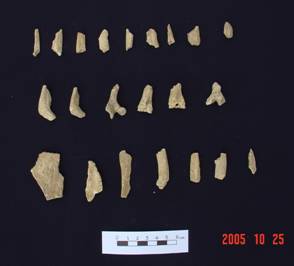
Figure
5.22 Animal
Bone in L3 of TP E1
5.1.10
Animal Tooth
An animal tooth (see Figure 5.23) were found in L3 of TP E1. However,
the species of this animal could not be determined.
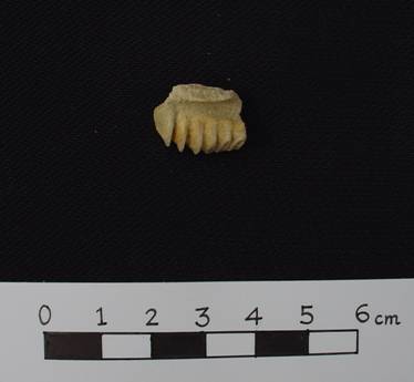
Figure
5.23 Animal
Tooth in L3 of TP E1
5.1.11
Archaeological Features
An archaeological feature refers to the remains of a structure or burial
ground. A total of three features were found
in this survey at Site B, one from TP B1 and two from TP B5.
One of the
features, recorded as L2/F1 of TP B1, is a secondary burial. This burial practice was commonly adopted in
the
The other two features were found in L4 of TP B5 in Site B. These were recorded as L4/F1 of TP B5 and
L4/F2of TP B5. L4/F1 contains a cluster
of pebbles, with a few quartz flakes, a quartz disc, a quartz core and two
pieces of pebble refitting flakes. A
broken quartz ring was also found near to the feature. The function of this
feature is uncertain. However, it
reflects the different stages of quartz ring manufacturing process (see Figures
4.7 and 5.18). L4/F2 of B5 contains a large boulder, a few rocks and a cluster of 10 quartz discs
beneath the large boulder (see Figures 4.7 and 5.19).
Based on the typology of the quartz ring and discs, F1 and F2 date back
to the Late Phase of Late Neolithic Age.
The representative
special finds identified in Shek Pik
are described below.
5.2.1
Pottery
Glazed Ware Shards
There were four pieces of glazed pot dark
brown and reddish colour shards found in L2 of SP1
(see Figure 5.24). The glaze and shard texture indicates these
pieces date back to the late 19th century to modern period.
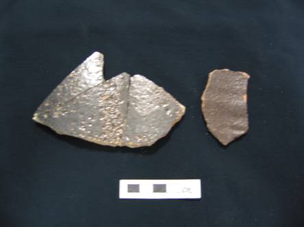
Figure 5.24 Dark
Brown Glazed Ware Shard (Left, 3 pieces pieced together)
Coarse Ware Shards
There were three pieces of coarse ware shard found in L2 of TP SP4 (see Figure 5.25). No decoration pattern can been found on the
shards surface. The shard section is
black in colour and coarse sand was observed in the section. These shards are
comparable with the same kind of finds found in
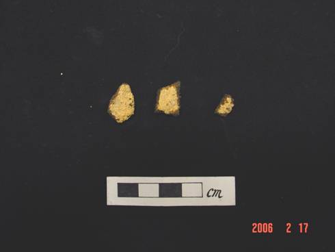
Figure 5.25 Coarse Ware Shards in L2 of SP4 at Shek
Pik Tung Wan
5.2.2
Lime Kiln Structure Remains
A total of three broken kiln bricks and a broken fired bar were found in
L2 of TP SP1 (see Figure 4.21). These finds indicate the presence of a kiln
at the site which dates back to Tang Dynasty (A.D. 618-907). Such an industry was very common in coastal
areas in
5.2.3
Stone Tools
Pebble Grinder
A grinder stone was found in L4 of TP SP1. The length of the stone is 9.7 cm. It was struck and a diffuse bulb of force is
observed. Owing to the flat surface, the
pebble stone is identifiable as a grinder (see Figure 5.26).
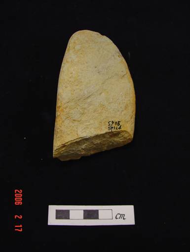
Figure 5.26 Pebble
Grinder in L3 of SP1 at Shek
Pik Tung Wan
5.2.4
Flakes
Three stone flakes (see Figures
5.27 to 5.29) were found in L4
and L5 of TP SP1. The first one was struck from a pebble. Its length is 13cm with a natural
surface. A cutting edge was identified
which resulted from flaking. A scar can be seen on the flake.
The second flake is made of light green tuff. Its length, measured along the flake axis, is
7.3cm. The thickness is measured at the highest point of force bulb, which is 1
cm. A striking platform, a striking
point and a bulb of force are found on the flake. A working edge with four notches is observed
at the left side of the flake axis.
The third flake was found from L5 of TP SP1. It was made of light green tuff. The length
of the flake is 12.1cm and the thickness is 3.8cm. A striking platform and a
natural surface are found on the flake. A flaking scar can be seen on both the
dorsal and ventral surfaces. A ridge
exists on the dorsal surface which is regarded as a feature of the flaking
control technique. The function of the
flake is uncertain.
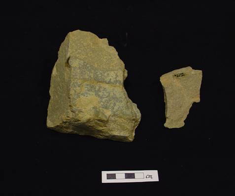
Figure 5.27 Stone Flakes in
L5(Left) and L4 (right) of SP1 at Shek Pik Tung Wan
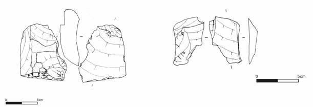
Figure 5.28 Drawings of
Stone Flakes in L5(Left) and L4 (right)
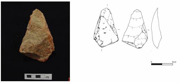
Figure 5.29 Stone Flake from
L5 of SP1 at Shek Pik Tung
Wan
6
ConclUsions
A total of 55 auger holes and 61 test pits and, 19 auger holes and 7
test pits were undertaken on the
On
Pottery artefacts identified in
At Shek Pik, archaeological potential exists at the raised beach
area and the foothill area within the Shek Pik Tung Wan Archaeological Site. Artefacts
identified include lime kiln remains dated to Tang Dynasty (A.D. 618-907) and
coarse ware shards and stone flakes dated to the Late Neolithic Age. However, no archaeological potential is
revealed from the survey at the area adjacent to the