Contents
3.2 Environmental Legislations,
Standards and Guidelines
3.3 Description of the Environment
3.4 Assessment Area and Identification
of Air Sensitive Receivers
3.5 Environmental Impacts during
Construction Phase
3.6 Environmental Impacts during
Operational Phase
Table 3.1: Air Quality Objectives
Table 3.2: Historical Air Quality from EPD’s
general monitoring station at Yuen Long
Table 3.3: Future Background Air Quality from
PATH for Year 2030
Table
3.4: Representative ASRs in the Vicinity of the Project
Table
3.5: Criteria and Non-criteria Pollutants and Odour Emissions from Chimneys
Table 3.6: Total Emission in Year 2030, 2033,
2036, 2040, 2043, 2045, 2048 and 2051 3-27
|
Assessment Area for Air Quality Impact Assessment (with PATH grids) |
|
|
Location of Representative Air Sensitive Receivers |
|
|
Location of Representative Air Sensitive Receivers (Sheet 1 of 2) |
|
|
Location of Representative Air Sensitive Receivers (Sheet 2 of 2) |
|
|
Construction Phasing Plan and Locations of Concurrent Projects |
|
|
Locations of Chimneys |
|
|
Locations of Bus Terminus, Bus Depot and Car Park with Heavy Goods Vehicle and Coach |
|
|
Contour of Cumulative 10th highest 24-hour Average RSP Concentration (µg/m3) at 1.5m Above Ground |
|
|
Contour of Cumulative Annual RSP Concentration (µg/m3) at 1.5m Above Ground |
|
|
Contour of Cumulative 36th highest 24-hour Average FSP Concentration (µg/m3) at 1.5m Above Ground |
|
|
Contour of Cumulative Annual FSP Concentration (µg/m3) at 1.5m Above Ground |
|
|
Contour of Cumulative 19th highest 1-hour Average NO2 Concentration (µg/m3) at 10.0m Above Ground |
|
|
Contour of Cumulative Annual NO2 Concentration (µg/m3) at 1.5m Above Ground |
|
|
Contour of Cumulative 4th highest 10-min SO2 Concentration (µg/m3) at 9.2m Above Ground |
|
|
Contour of Cumulative 4th highest 24-hour Average SO2 Concentration (µg/m3) at 1.5m Above Ground |
Appendices
|
Details of Representative Air Sensitive Receivers |
|
|
Fresh Air Intake via Earth Cooling Tube |
|
|
Traffic Forecast and Speed Profiles |
|
|
Industrial Emission Sources more than 500m away from Air Sensitive Uses of the Proposed Development |
|
|
Model Input Parameters for Vehicular Emissions from Open Roads |
|
|
Composite Emission Factors and Sensitivity Test |
|
|
Surface Parameters for AERMOD Meteorological Data |
|
|
Emission Inventory for Chimneys Sources |
|
|
Emission Inventory for Bus Terminus, Bus Depot and Car Park with Heavy Goods Vehicle and Coach |
|
|
Derivation of Cumulative Annual Average NOx to NO2 Conversion Using Jenkin Method |
|
|
Detailed Cumulative Modelling Results during Operation Phase |
|
|
Assessment of Air Sensitive Uses Within Exceedance Zones |
|
AERMET |
Meteorological data pre-processor for AERMOD |
|
AERMOD |
American Meteorological Society/Environmental Protection Agency Regulatory Model |
|
AP-42 |
5th edition of Compilation of Air Pollution Emission Factors issued by USEPA |
|
APCO |
Air Pollution Control Ordinance |
|
AQMS |
Air Quality Monitoring Station |
|
AQO |
Air Quality Objective |
|
ASR |
Air Sensitive Receiver |
|
CDWE |
Comprehensive Development with Wetland Enhancement |
|
CO |
Carbon Monoxide |
|
Corinair |
Core Inventory Air Emissions |
|
C&D |
Construction and Demolition |
|
D.D. |
Demarcation District |
|
DPM |
Diesel Particulate Matter |
|
DS |
Development Site |
|
DSD |
Drainage Services Department |
|
EC |
Elemental Carbon |
|
EIA |
Environmental Impact Assessment |
|
EIAO |
Environmental Impact Assessment Ordinance |
|
EIAO-TM |
Technical Memorandum on Environmental Impact Assessment Process |
|
EMEP |
European Monitoring and Evaluation Programme |
|
EMFAC-HK |
Vehicle emission calculation model, EMission-FACtor-Hong Kong (EMFAC-HK) Version 4.3 |
|
EPD |
Environmental Protection Department |
|
EU |
European Union |
|
FSP |
Fine Suspended Particulates |
|
H2S |
Hydrogen Sulphide |
|
HKO |
Hong Kong Observatory |
|
HKPSG |
Hong Kong Planning Standards and Guidelines |
|
IDC |
Investigation, Design and Construction |
|
LC |
Lut Chau |
|
LSPS |
Land Sharing Pilot Scheme |
|
MSBs |
Multi-Storey Buildings |
|
NH3 |
Ammonia |
|
NO2 |
Nitrogen Dioxide |
|
NOx |
Nitrogen Oxides |
|
NRMM |
Non-road Mobile Machinery |
|
NSW |
Nam Sang Wai |
|
NTN |
New Territories North |
|
O3 |
Ozone |
|
OEHHA |
Office of Environmental Health Hazard Assessment, California, USA |
|
OLM |
Ozone Limiting Method |
|
OSHA |
Occupational Safety and Health Administration, USA |
|
OU |
Odour Units |
|
PAHs |
Polycyclic Aromatic Hydrocarbons |
|
PATH |
Pollutants in the Atmosphere and their Transport over Hong Kong Model Version 3.0 |
|
Pb |
Lead |
|
PCB |
Polychlorinated Biphenyls |
|
PEL |
Permissible Exposure Limit |
|
PER |
Preliminary Environmental Review |
|
PM |
Particulate Matter |
|
PM2.5 |
Fine Suspended Particulates (FSP or PM2.5) |
|
PM10 |
Respirable Suspended Particulates (RSP or PM10) |
|
PMEs |
Powered Mechanical Equipment |
|
RCP |
Refuse Collection Point |
|
RCV |
Refuse Collection Vehicle |
|
REL |
Reference Exposure Levels |
|
RSP |
Respirable Suspended Particulates |
|
RTS |
Refuse Transfer Stations |
|
SAMP |
EPD’s Smart Air Modelling Platform |
|
SO2 |
Sulphur Dioxide |
|
SP |
Specified Process |
|
SPS |
Sewage Pumping Station |
|
TAPs |
Toxic Air Pollutants |
|
TD |
Transport Department |
|
TOC |
Total Organic Carbons |
|
UK |
United Kingdom |
|
USEPA |
United States Environmental Protection Agency |
|
VKT |
Vehicle Kilometre Travelled |
|
VOCs |
Volatile Organic Compounds |
|
WCP |
Wetland Conservation Park |
|
WLP |
Wetland Park Station |
|
WRF |
Weather Research and Forecasting |
|
YLEPP |
Yuen Long Effluent Polishing Plant |
|
YLEPP EIA |
Yuen Long Effluent Polishing Plant Environmental Impact Assessment study (AEIAR-220/2019) |
|
YLIE |
Yuen Long Industrial Estate |
3
Air Quality Impact
3.1
Introduction
3.1.1
This section presents
the assessment of potential air quality impacts associated with the
construction and operational phases of the proposed comprehensive development
with wetland enhancement (CDWE) at Nam Sang Wai (NSW) and Lut
Chau (LC).
3.1.2
Representative Air
Sensitive Receivers (ASRs) within the 500m Assessment Area have been identified
and the worst-case impacts on these receivers have been assessed. Suitable
mitigation measures have been recommended accordingly, in order to comply with
relevant criteria.
3.2
Environmental
Legislations, Standards and Guidelines
3.2.1
Air quality impact assessment has been carried
out in accordance with the relevant criteria and standards as specified in the
following legislation and guidelines:
● Environmental Impact Assessment
Ordinance (EIAO) (Cap. 499), EIAO-TM, Annexes 4 and 12;
● Air Pollution Control Ordinance
(APCO) (Cap. 311);
● Air Pollution Control (Construction
Dust) Regulation;
● Air Pollution Control (Non-road Mobile Machinery) (Emission) Regulation; and
● Air Pollution Control (Fuel Restriction) Regulation.
Technical
Memorandum on Environmental Impact Assessment Process
3.2.2
The criteria and
guidelines for evaluating air quality impacts are laid out in Section 1 of
Annex 4 and Annex 12 of the EIAO-TM, respectively. Section 1 of Annex 4
stipulates the criteria for evaluating air quality impacts. This includes
meeting the Air Quality Objectives (AQOs) and other standards established under
the APCO, as well as meeting the hourly Total Suspended Particulate (TSP)
concentration of 500 μg/m3 and the
5-second average odour concentration of 5 odour units (ou/m3).
Annex 12 provides the guidelines for conducting air quality assessments under
the EIA process, including determination of Air Sensitive Receivers (ASRs),
assessment methodology as well as impact prediction and assessment.
Air
Pollution Control Ordinance
Air
Quality Objectives
3.2.3
The principal
legislation for the management of air quality is the APCO. The APCO specifies
Air Quality Objectives (AQOs) which stipulate the statutory limits of air
pollutants and the maximum allowable numbers of exceedances over specific
periods. The prevailing AQOs which have been effective since 1st January 2022
are listed in Table 3.1 below.
Table
3.1: Air Quality Objectives
|
Pollutant |
Averaging time |
Concentration[i] (µg/m3) |
Number of exceedances allowed |
|
Respirable Suspended Particulates (PM10) [ii] |
24-hour |
100 |
9 |
|
Annual |
50 |
Not applicable |
|
|
Fine Suspended Particulates (PM2.5) [iii] |
24-hour |
50 |
35 [iv] |
|
Annual |
25 |
Not applicable |
|
|
Nitrogen Dioxide (NO2) |
1-hour |
200 |
18 |
|
Annual |
40 |
Not applicable |
|
|
Sulphur Dioxide (SO2) |
10-minute |
500 |
3 |
|
24-hour |
50 |
3 |
|
|
Ozone (O3) |
8-hour |
160 |
9 |
|
Carbon Monoxide (CO) |
1-hour |
30,000 |
0 |
|
8-hour |
10,000 |
0 |
|
|
Lead (Pb) |
Annual |
0.5 |
Not applicable |
Notes:
[i]. All
measurements of the concentration of gaseous air pollutants, i.e., sulphur
dioxide, nitrogen dioxide, ozone and carbon monoxide, are to be adjusted to a
reference temperature of 293 Kelvin and a reference pressure of
101.325 kilopascal.
[ii]. Respirable
suspended particulates mean suspended particles in air with a nominal
aerodynamic diameter of 10 µm or less.
[iii]. Fine suspended particulates
mean suspended particles in air with a nominal aerodynamic diameter of
2.5 µm or less.
[iv]. The allowable exceedance for
government projects is 18.
Air
Pollution Control (Construction Dust) Regulation
3.2.4
The Air Pollution
Control (Construction Dust) Regulation enacted under the APCO defines
notifiable and regulatory works activities that are subject to construction
dust control. Notifiable works are site formation, reclamation, demolition of a
building, construction of foundation and superstructure for a building, and
road construction work. Regulatory works are renovation of building, road
opening or resurfacing work, slope stabilisation work, and any work involving
stockpiling, loading and unloading of dusty material, transfer of dusty
material using belt conveyor system, etc.
3.2.5
Notifiable works
require that advance notice of activities shall be given to EPD. The Air
Pollution Control (Construction Dust) Regulation also requires the works
Contractor to ensure that both notifiable works and regulatory works are
conducted in accordance with the Schedule of Regulation, which provides dust
control and suppression measures.
Air
Pollution Control (Non-road Mobile Machinery)
(Emission) Regulation
3.2.6
The Air Pollution
Control (Non-road Mobile Machinery) (Emission)
Regulation controls the emissions from non-road vehicle and regulated machines
to be used in construction sites. The regulated machines must comply with the
emission standards of Stage IIIA of the European Union (EU) or equivalent.
Non-road vehicles that are not licensed under the Road Traffic (Registration
and Licensing of Vehicles) Regulations (Cap. 374E) are required to comply with
the Euro VI / California LEV III emission standards. Upon confirmation of their
compliance with the emission requirement, EPD will issue them with an approval
label.
3.2.7
According to the
regulation, mobile machine and equipment (regulated machines) means any mobile
machine or transportable industrial equipment that is powered by an internal
combustion engine with a rated engine power output that is greater than 19 kW
but less than or equal to 560 kW. Non-road Mobile Machinery (NRMM) is
intended to be used in a private road that is within an area wholly or mainly
used for the carrying on of construction work/industry. Regulated machines
include crawler cranes, excavators, etc., while non-road vehicles mean private
cars, goods vehicles, etc. Therefore, this regulation is applicable to the
regulated machines and non-road vehicles (if any) to be deployed for
construction activities of the Project.
Air
Pollution Control (Fuel Restriction) Regulation
3.2.8
The Air Pollution
Control (Fuel Restriction) Regulation specifies the legal control on the type
of fuels to be allowed for use and the sulphur contents of the fuels. With the
exception of Shatin district, the fuels to be used should comply with the following
respective requirements:
● Gaseous fuel; and
● Liquid fuel with a sulphur content
not exceeding 0.005% by weight and a viscosity not more than 6 centistokes
at 40°C, such as Ultra Low Sulphur Diesel (“ULSD”)
3.3
Description
of the Environment
Local Environment
3.3.1
The Project consists of
two separate sites located in NSW and LC, Yuen Long. These mainly consists of
wetlands and fishponds. Yuen Long Industrial Estate is approximately 120m west
of the NSW site. There is no major road in the vicinity of the Project Site.
Baseline Condition
3.3.2
Historical background air quality has been
referenced from EPD’s general air quality monitoring station (AQMS) located in
Yuen Long, which is closest to the NSW site. The recent five years’ monitoring
data (Year 2019 – 2023) recorded at the AQMS in Yuen Long is presented in Table 3.2.
Table
3.2: Historical Air Quality from EPD’s general monitoring station at Yuen Long
|
Pollutant |
Averaging Period |
Concentration (µg/m3) |
Corresponding AQOs (µg/m3) |
|||||
|
2019 |
2020 |
2021 |
2022 |
2023 |
5-year annual average |
|||
|
Respirable Suspended Particulates (RSP or PM10) |
24-hour - 10th highest |
83 |
77 |
73 |
56 |
59 |
70 |
100 |
|
Annual |
37 |
30 |
30 |
25 |
26 |
30 |
50 |
|
|
Fine Suspended Particulates (FSP or PM2.5) |
24-hour - 36th highest |
34 |
28 |
31 |
30 |
30 |
31 |
50 |
|
Annual |
20 |
16 |
17 |
16 |
16 |
17 |
25 |
|
|
Nitrogen Dioxide (NO2) |
1-hour - 19th highest |
161 |
135 |
148 |
122 |
130 |
139 |
200 |
|
Annual |
44 |
32 |
40 |
37 |
37 |
38 |
40 |
|
|
Sulphur Dioxide (SO2) |
10-minute - 4th highest |
42 |
26 |
24 |
21 |
20 |
27 |
500 |
|
24-hour - 4th highest |
11 |
10 |
14 |
7 |
10 |
10 |
50 |
|
|
Ozone (O3) |
8-hour - 10th highest |
200 |
154 |
178 |
194 |
155 |
176 |
160 |
|
Carbon Monoxide (CO) |
1-hour |
2,150 |
1,530 |
2,090 |
1,700 |
1,580 |
1,810 |
30,000 |
|
8-hour |
1,903 |
1,279 |
1,591 |
1,519 |
1,273 |
1,513 |
10,000 |
|
Notes:
[i]. Data extracted
from EPD’s Smart Air Modelling Platform (SAMP) v2.0.
[ii]. Monitoring
results that exceeded prevailing AQO criteria are shown in bold
characters.
3.3.3
The predicted future
background air pollutant concentrations within the Assessment Area are
extracted from relevant grids of the Pollutants in the Atmosphere and their
Transport over Hong Kong (PATH) v.3.0 model for Year 2030 and are summarised in
Table 3.3 below. Year 2030 is referenced being the planned Phase 1
population intake year of the Project.
Table
3.3: Future Background Air Quality from PATH for Year 2030
|
Pollu-tant |
Averaging Period |
Concentration (µg/m3) |
Corres-ponding AQOs (µg/m3) |
|||||||||||
|
25, 48 |
25, 49 |
25, 50 |
25, 51 |
26, 48 |
26, 49 |
26, 50 |
26, 51 |
27, 48 |
27, 49 |
27, 50 |
27, 51 |
|||
|
RSP/ PM10 |
24-hour - 10th Highest |
53 |
53 |
54 |
54 |
53 |
53 |
53 |
53 |
55 |
52 |
52 |
53 |
100 |
|
Annual |
20 |
20 |
20 |
20 |
20 |
20 |
20 |
20 |
21 |
20 |
20 |
20 |
50 |
|
|
FSP/ PM2.5 |
24-hour - 36th Highest |
26 |
26 |
26 |
26 |
26 |
26 |
26 |
26 |
28 |
26 |
26 |
26 |
50 |
|
Annual |
12 |
12 |
12 |
12 |
12 |
12 |
12 |
12 |
13 |
12 |
12 |
12 |
25 |
|
|
NO2 |
1-hour - 19th Highest |
76 |
74 |
74 |
75 |
75 |
75 |
76 |
76 |
74 |
73 |
73 |
74 |
200 |
|
Annual |
16 |
15 |
14 |
14 |
15 |
14 |
14 |
14 |
14 |
14 |
14 |
14 |
40 |
|
|
SO2 |
10-min - 4th Highest |
25 |
25 |
25 |
25 |
24 |
25 |
25 |
25 |
24 |
24 |
24 |
24 |
500 |
|
24-hour - 4th Highest |
7 |
7 |
7 |
7 |
7 |
7 |
7 |
7 |
7 |
7 |
7 |
7 |
50 |
|
|
O3 |
8-hour - 10th Highest |
190 |
190 |
189 |
186 |
186 |
188 |
189 |
186 |
181 |
184 |
189 |
190 |
160 |
|
CO |
1-hour |
522 |
522 |
522 |
523 |
520 |
521 |
521 |
522 |
522 |
523 |
523 |
523 |
30,000 |
|
8-hour |
487 |
487 |
485 |
484 |
489 |
490 |
489 |
489 |
491 |
491 |
491 |
492 |
10,000 |
|
Notes:
[i]. Data extracted
from EPD’s Smart Air Modelling Platform (SAMP) v2.0.
3.3.4
As shown in Table
3.3, future background levels of hourly and annual NO2, daily
and annual RSP and FSP and 10-min and daily SO2 would be below their
corresponding AQOs by 2030. The improvement in future ambient air quality can
be attributed to the government’s commitment to implement various planned
emission reduction measures, as published on EPD’s website[1].
3.4
Assessment
Area and Identification of Air Sensitive Receivers
3.4.1
The Assessment Area is
defined as an area within 500m from the Project Boundary, as shown in Figure
3.1.
3.4.2
Referring to Annex 12
of the EIAO-TM, any domestic premises, hotel, hostel, hospital, clinic,
nursery, temporary housing accommodation, school, educational institution,
office, factory, shop, shopping centre, place of public worship, library, court
of law, sports stadium or performing arts centre should be classified as Air
Sensitive Receivers (ASRs). Any other premises or place with similar duration
or number of people to be affected as the above premises and places should also
be considered as ASRs.
3.4.3
Representative ASRs
(both existing or planned) that may be affected by the Project within the 500m
Assessment Area are shown in Figure 3.2A to Figure 3.2C. A
summary and details of representative ASRs are presented in Table 3.4 and Appendix 3.1.
3.4.4
In order to minimise
the impact from Yuen Long Industrial Estate (YLIE) on the planned residential
development at NSW Development Site (DS), particularly to the planned
air-conditioned Visitor Centre (P01), the fresh air
intake for this building will be designed to be located further away from the
industrial estate via an earth cooling tube. The tentative fresh air-intake
location is presented in Appendix 3.4. Therefore, no openable
window is provided for the Visitor Centre. It is not uncommon to have fresh air
drawn into a building via an earth cooling tube. An example of this practice
would be the CIC Zero Carbon Park as presented in Appendix 3.2. The
exact location of the Visitor Centre or its fresh air intake will be further
reviewed during the detailed design stage. In any case, the air-sensitive uses
of the visitor centre including openable window and fresh air intake shall not
be located within 500m of the air emission sources during the detailed design
stage.
Table 3.4: Representative ASRs in the Vicinity of
the Project
|
ASR ID |
Description |
Type of Use |
Approximate Horizontal Distance from Project Boundary (m) |
Approximate Horizontal Distance from Phase 1 Construction (m) |
Approximate Horizontal Distance from Phase 2 Construction (m) |
Approximate Horizontal Distance from Phase 3 Construction (m) |
Assessment Height Above Ground (mAG) |
Construction Phase |
Operational Phase |
|
Existing ASRs |
|
||||||||
|
A01 |
Nestle Hong Kong Ltd |
I |
422 |
718 |
847 |
855 |
1.5 - 10.0 |
ü |
ü |
|
A02 |
Hong Kong Petrochemical Co., Ltd |
I |
268 |
816 |
978 |
1,008 |
1.5 - 10.0 |
ü |
ü |
|
A03 |
Viva Manufacturing |
I |
210 |
569 |
724 |
751 |
1.5 - 20.0 |
ü |
ü |
|
A04 |
Chiho-Tiande Group Limited |
I |
297 |
509 |
524 |
524 |
1.5 - 10.0 |
ü |
ü |
|
A05 |
Nin Jiom Medicine Manufactory HK Ltd |
I |
307 |
491 |
491 |
453 |
1.5 - 10.0 |
ü |
ü |
|
A06 |
Shan Pui Chung Hau Tsuen |
R |
360 |
637 |
637 |
493 |
1.5 - 10.0 |
ü |
ü |
|
A07 |
Transitional Housing - United Court |
R |
199 |
539 |
539 |
346 |
1.5 - 10.0 |
ü |
ü |
|
A08 |
Village House near United Court |
R |
307 |
737 |
680 |
464 |
1.5 - 10.0 |
ü |
ü |
|
A09 |
The Parcville Tower |
R |
382 |
800 |
747 |
530 |
1.5 - 35.0 |
ü |
ü |
|
A10 |
Shan Pui Hung Tin Tsuen |
R |
263 |
719 |
628 |
396 |
1.5 - 10.0 |
ü |
ü |
|
A11 |
Shan Pui Tsuen |
R |
234 |
661 |
567 |
351 |
1.5 - 10.0 |
ü |
ü |
|
A12 |
Zen River |
R |
200 |
654 |
560 |
334 |
1.5 - 10.0 |
ü |
ü |
|
A13 |
Houses near Yuen Long Road Safety Centre |
R |
44 |
475 |
415 |
200 |
1.5 - 10.0 |
ü |
ü |
|
A14 |
Yuen Long Road Safety Centre |
E |
129 |
431 |
394 |
256 |
1.5 |
ü |
ü |
|
A15 |
Houses near Yuen Long Road Safety Centre |
R |
37 |
308 |
286 |
180 |
1.5 |
ü |
ü |
|
A16 |
Chung Hau Yu Man San Tsuen |
R |
11 |
353 |
263 |
28 |
1.5 - 10.0 |
ü |
ü |
|
A17 |
Nam Sang Wai village houses |
R |
302 |
581 |
581 |
634 |
1.5 - 10.0 |
ü |
ü |
|
A18 |
Fairview Park |
R |
480 |
1,772 |
1,939 |
2,116 |
1.5 - 10.0 |
ü |
ü |
|
A19 |
Lut Chau |
R |
126 |
1,381 |
1,518 |
1,679 |
1.5 |
ü |
ü |
|
A20 |
Leeman Hydraulic |
I |
145 |
186 |
241 |
246 |
1.5 - 10.0 |
ü |
ü |
|
A21 |
Fortune Pharmacal |
I |
27 |
298 |
298 |
303 |
1.5 - 10.0 |
ü |
ü |
|
A22 |
Village House near Lut Chau |
R |
368 |
1,560 |
1,742 |
1,810 |
1.5 - 10.0 |
ü |
ü |
|
A23 |
Village House near Fairview Park |
R |
274 |
1,652 |
1,816 |
1,981 |
1.5 - 10.0 |
ü |
ü |
|
A24 |
59 Wang Lok Street (near car park) |
I |
14 |
266 |
299 |
278 |
1.5 - 20.0 |
ü |
ü |
|
Planned ASRs |
|
||||||||
|
C01 |
Private Housing Development at D.D. 115 at Chung Yip Road, Nam San Wai * |
R |
66 |
499 |
468 |
316 |
1.5 - 10.0 |
ü |
ü |
|
P01 |
Fresh air intake for Visitor Centre |
Rec |
Within Project Site |
Phase 1 development |
613 |
660 |
1.5 - 9.2 |
Phase 2 & 3 |
ü |
|
P02 |
Elderly Centre |
HE |
Within Project Site |
Phase 1 development |
185 |
254 |
1.5 - 22.0 |
Phase 2 & 3 |
ü |
|
P03 |
Residential Development 25 Floors (Phase 1) ** |
R |
Within Project Site |
Phase 1 development |
105 |
171 |
1.5 - 82.8 |
Phase 2 & 3 |
ü |
|
P04 |
Residential Development 25 Floors (Phase 1) ** |
R |
Within Project Site |
Phase 1 development |
16 |
76 |
1.5 - 82.8 |
Phase 2 & 3 |
ü |
|
P05 |
Residential Development 22 Floors (Phase 3) ** |
R |
Within Project Site |
NA |
NA |
Phase 3 development |
1.5 - 73.2 |
× |
ü |
|
P06 |
Residential Development 19 Floors (Phase 3) ** |
R |
Within Project Site |
NA |
NA |
Phase 3 development |
1.5 - 63.6 |
× |
ü |
|
P07 |
Residential Development 19 Floors (Phase 3) ** |
R |
Within Project Site |
NA |
NA |
Phase 3 development |
1.5 - 63.6 |
× |
ü |
|
P08 |
House (3-storey) (Phase 2) ** |
R |
Within Project Site |
NA |
Phase 2 development |
10 |
1.5 - 12.4 |
Phase 3 |
ü |
|
P09 |
House (3-storey) (Phase 2) ** |
R |
Within Project Site |
NA |
Phase 2 development |
10 |
1.5 - 12.4 |
Phase 3 |
ü |
|
P10 |
Residential Development 22 Floors (Phase 2) ** |
R |
Within Project Site |
NA |
Phase 2 development |
10 |
1.5 - 73.2 |
Phase 3 |
ü |
|
P11 |
House (3-storey) (Phase 1) ** |
R |
Within Project Site |
Phase 1 development |
20 |
178 |
1.5 - 12.4 |
Phase 2 & 3 |
ü |
|
P12 |
Residential Development 20 Floors (Phase 1) ** |
R |
Within Project Site |
Phase 1 development |
10 |
166 |
1.5 - 66.8 |
Phase 2 & 3 |
ü |
|
P13 |
House (3-storey) (Phase 1) ** |
R |
Within Project Site |
Phase 1 development |
10 |
174 |
1.5 - 12.4 |
Phase 2 & 3 |
ü |
|
P14 |
Proposed Public Park |
Rec |
Within Project Site |
Phase 1 development |
353 |
405 |
1.5 |
Phase 2 & 3 |
ü |
|
P15 |
Proposed Public Park |
Rec |
Within Project Site |
Phase 1 development |
53 |
75 |
1.5 |
Phase 2 & 3 |
ü |
Notes:
ü
Applicable to all phases (Phase 1, Phase 2 and Phase 3) of the construction
phase, respectively
×
Not applicable
*ASR C01 is assumed to be included
during the construction phase, as a conservative approach, since the population
intake year for this ASR is unknown.
**For P03 to P13, (Phase X) means
population intake phase
Type of use: I – Industrial; R –
Residential; E – Educational; Rec – Recreational; HE – Home for the elderly
Assessment height intervals for A01 –
A24 & C01 are at 1.5m, 5m, and at 5m intervals from then on, as applicable.
For details refer to Appendix 3.1.
Assessment height intervals for the
planned development (P01 – P15) were determined according to floor level plans.
For details refer to Appendix 3.1. The full range of assessment heights
have been covered for each ASR.
3.5
Environmental Impacts during Construction Phase
3.5.1
Referring to the
tentative construction programme as shown in Appendix 2.1, the
construction works consist of four phases of pond enhancement at the LC site
and wetland enhancement at the NSW site, construction of the proposed bridge,
three phases of residential development at NSW DS and construction of a visitor
centre cum public park in parallel with Phase 1 of the DS. The locations of the
tentative construction phases are shown in Figure 2.8. The population
intake will be phased in line with the construction phases of the residential
development. Each phase will begin to be occupied upon completion of its
construction works.
Identification of Pollution Sources
3.5.2
The major potential
pollution sources of air quality impact during the construction phase would be
fugitive dust arising from site clearance, site formation, excavation and
piling works. Potential dust emission sources of the Project are identified as
follows:
● Construction works within the works site including bulk excavation
works, handling of dusty materials and temporary stockpiling of dusty
materials;
● Wind erosion from excavated areas
and stockpiles; and
● Use of construction/ dump trucks for
construction works.
3.5.3
Potential odour may be
generated from the excavation of bed materials of fishponds and wetland.
3.5.4
On-site use of
diesel-powered engines is a potential source for particulate matter (PM) and
gaseous pollutants (e.g., NO2 and SO2). A phased
programme would be adopted during the construction phase to minimise
construction air quality impact. Diesel Powered Mechanical Equipment (PMEs)
would be mainly used in the area for the DS. The PME would have separation
distances of at least 186m, 241m and 28m from non-Project ASRs during the
construction of Phase 1, Phase 2 and Phase 3 respectively, and a separation
distance of at least 10m from its own Project ASRs (i.e., population intake of
the DS). However, no more than 31 numbers of PMEs
(including diesel PME) would be operated at the same time under normal
operation and only about 10% of the construction period would use more than
28 numbers of PME at a time. Given that the area of Phase 1 is the largest in
the DS, it is expected that the highest number of PMEs would be employed during
said phase. As mentioned, the separation distance of Phase 1 from non-Project
ASRs is 186m and there would be no population intake of Project ASRs during
Phase 1. During the construction of Phase 2 and Phase 3, hoarding higher than
2.4m will be erected along the boundary as planned ASRs would be closer to the
works boundary.
3.5.5
With proper maintenance
of PMEs, limited gaseous emissions and smoke would be generated from such
equipment. In addition, the Air Pollution Control (Non-road
Mobile Machinery) (Emission) Regulation came into effect in June 2015 to
control emissions from diesel-powered engines, fuel with sulphur content not
exceeding 0.005% by weight will be used to minimize SO2 emission in
accordance with the Air Pollution Control (Fuel Restriction) Regulation. The
use of NRMMs with exempted label under the Air Pollution Control (NRMM)
Regulation will be avoided as far as practicable. Also, electrified NRMMs will
be employed as far as practicable, which are unlikely to cause significant
smoke and gaseous emissions. Alternative power supply such as off-grid power
storage, e.g., AMPD Enertainer, will also be
considered where feasible. With the abovementioned regulations being followed,
together with the Air Pollution Control (Smoke) Regulation, the limited number
of diesel-powered engines employed, their limited operation hours, and with the
implementation of good site practices and the control measures as presented in Paragraph
3.5.27, the air quality impact from the operation of on-site diesel PMEs is
considered to be limited and localised.
3.5.6
In view of the minor
impact by NRMMs, fugitive dust (particulates) and odour would be the primary
concerns of air quality impact during the construction phase.
Prediction and Evaluation of Air Quality Impacts
during Construction Phase
Fugitive Dust
3.5.7
There are no demolition
and road improvement works of existing roads proposed
for the Project. Apart from the area for the DS and proposed public park, the
rest of Project Site would be for wetland and pond enhancement works which
involve modification of wetlands during the creation of the Wetland Enhancement
Area at NSW site and LC Nature Reserve. No percussive piling works would be
conducted to minimise the disturbance on the area and excavated materials from
the area will be generally wet. The average excavation area would be around
100 m2 at each of the sites at any time. In addition, the
enhancement works will be well-controlled by the implementation of dust
suppression measures as presented in Paragraph 3.5.27. Hence, dust
nuisance from wetland and pond enhancement works is anticipated to be limited.
The amount of excavation material for the construction of the proposed bridge
is approximately 4,000 m3 only. The impact of construction work for
the proposed bridge across Shan Pui River is also considered as minimal due to
limited excavation works, piling works and the use of prefabricated building
parts. No excavation work is proposed at Shan Pui River.
3.5.8
The major dust
generation works are considered to be the site
formation and excavation works in the DS which will be conducted in 3
phases (Phase 1 to Phase 3) as shown in Figure 3.3. The total area of
the development of the DS is approximately 11.6 ha. Phase 1 to Phase 3 would
include site formation and excavation works, substructure works, civil and road
works for the residential development and landscaping works. Phase 1 of the development
would also include enhancement works of the existing public park adjacent to
Shan Pui River and the construction of a visitor centre and Sewage Pumping
Station (SPS). Construction works for the public park are mainly landscaping
works. The excavation area of the visitor centre will be around 680 m2
only. With reference to Table 3.4,
the major dust generation works (e.g., site formation and excavation works) are
about 28m away from the closest existing ASR and 10m away from the planned
ASRs. In order to minimise the fugitive dust impact, the 3 phases of the site
formation and excavation works would not be carried out concurrently. Each of
the excavation work areas would be around 100 m2 in size to minimise
construction dust impact. In addition, proper programming arrangement shall be
considered to maximise separation distances between dust generating works and
planned ASRs (e.g., conduct dust generating works near planned ASRs prior to
their population intake). Moreover, dust suppression measures should be
properly implemented, such as regular watering and erection of solid barrier
with a height of 3.5m (subject to site constraints) in front of the air
sensitive façade facing the work site to shield off concerned ASRs from nearby
dust emission sources. Based on the above, no adverse impact from dust generation
works is anticipated.
3.5.9
According to the
engineering design, the estimated total amount of construction and demolition
(C&D) materials to be deposited for the whole construction period at NSW
site is about 372,200 m3 and the LC site is about 3,300 m3.
65,000 m3 of inert material will be reused on-site for the LC site.
The remaining inert material will be delivered to the public fill reception
facility or other concurrent construction projects for reuse. The recyclable
non-inert C&D materials will be recycled and the remaining non-recyclable
portion will be disposed of at landfill. Based on information provided by the
Design Engineers, it can be estimated that there would be around 50 no. of
trips of dump truck per day for transporting waste serving for both sites
during peak construction period. All construction vehicles will be wheel-washed
thoroughly, and dusty contents will be well covered before leaving the site.
Hence, the dust impact from use of dump trucks is considered to be
insignificant. C&D materials exclude excavated pond mud as all excavated
pond mud is proposed to be reused onsite.
3.5.10
Moreover, construction
dust monitoring is also proposed as part of the EM&A programme for the
Project (Chapter 14), to confirm that the recommended mitigation
measures are properly implemented and are effective in ensuring that no nearby
ASRs are subjected to adverse air quality impact.
Odour
3.5.11
Depending on the
quality of the bed material of fishponds and wetland, odour may be generated
from their excavation. In order to minimise odour impact, excavation works for
fishponds and wetland should be conducted in the shortest time span possible.
Programming of the excavation works of bed materials should be minimised. As
mentioned in Chapter 4, the proposed habitat modification works will be
restricted to no more than four ponds, mostly adjacent to each other, at any
one time. The duration of the works at each pond will be less than one month.
The separation distance between the pond enhancement works at Lut Chau and the nearest ASR (A19) is approximately 126 m
as shown in Table
3.4 and Figure
3.3. The distance between the closest ASR (A16) and the Nam San Wai wetland
enhancement works area is 11 m as presented in Table 3.4 and Figure 3.3. If necessary, the
Contractors should also liaise with local resident to inform them of the duration
of potential odour nuisance, and efforts made to minimise and mitigate odour
nuisance. Odorous excavated material should be placed as far away from ASRs as
possible. Temporary stockpiles of odorous excavated material should be covered
with impervious sheet. With the implementation of good site practice
recommended in Paragraph 3.5.27, no unacceptable odour nuisance is
anticipated.
Cumulative impacts from concurrent projects
3.5.12
As mentioned in Section
2.9, there are few concurrent projects within the Assessment Area which may
have cumulative impacts. The locations of the concurrent projects and the
construction works area of the Project are shown in Figure 3.3, where
available. Close liaison with contractors of the concurrent projects will be
conducted to avoid overlapping of dusty activities as far as possible.
Yuen Long Barrage Scheme
(AEIAR-228/2021)
3.5.13
According to the
tentative construction programme under the approved EIA (AEIAR-228/2021),
construction works for the section of the barrage scheme within the Assessment
Area started in Q2 2023 and will be completed by 2030. Between the commencement
year of the construction works of the proposed NSW DS in 2025 and Year 2030,
the potential overlapping construction works of the barrage scheme will be
superstructure works of pumping stations, installation of tidal barrier and
widening and deepening of the Yuen Long Nullah. The construction air quality
impact of superstructure works is considered as minimal. The tidal barrier
installation is considered small scale with limited impact. Adverse air quality
impact from the enhancement of the nullah is also not anticipated with the
implementation of air quality control measures as stipulated in the Air
Pollution Control (Construction Dust) Regulation under the APCO. Potential
odour from construction activities related to the enhancement of the nullah
such as excavation and handling of nullah bed material are also expected to be
localised and minimal given the scale of the Project. Hence, the cumulative
impact with this Project is anticipated to be limited.
Yuen Long Effluent Polishing Plant
(AEIAR-220/2019)
3.5.14
Based on the latest
information available, the construction works of YLEPP started in November 2022
and will be completed by 2026/2027. The YLEPP project is about 130 m from the
NSW site (1 km from the DS) and approximately 400 m from the LC site. Between
the commencement year of the construction works of the proposed NSW DS in 2025
and Year 2027, most of the YLEPP construction works in Phase 1 will be
superstructure and small scale demolition works (i.e.,
of a 2-storey building, gas holders and sediment tanks). During Phase 2
construction of YLEPP, the main air quality impact of the proposed Project will
be site formation and excavation works at the NSW DS which is approximately 1
km from YLEPP. In addition, sediment and sludge tanks of YLEPP will be cleaned
before demolition. Hence cumulative impact is anticipated to be minimal.
Improvement of Yuen Long Town Nullah
(Town Centre Section) (AEIAR-223/2020)
3.5.15
With reference to the
EIA study for this project (AEIAR-223/2020), construction is expected to
commence in Q2 2024 for completion in Q1 2027. The works for the improvement of
Yuen Long Nullah within the Project’s Assessment Area will be mainly construction
of rising main, with sections that will use trenchless method. The air quality
impact of the project is considered to be limited due to the relatively small
scale of its construction works and quantity of excavated material. Therefore, the
cumulative impact of this project is anticipated to be minimal.
Proposed Private Residential
Development in D.D.115 at Chung Yip Road, Nam Sang Wai, Yuen Long (Approved
Planning Application No. A/YL-NSW/282)
3.5.16
The Lands Department
announced on 17 August 2021 the land tender award of the site. However, there
is no publicly available information on this development's construction and
occupation programme. The site is approximately 1.5 ha. This proposed private
residential development is approximately 160 m from the Project Boundary and
more than 250 m away from the DS.
3.5.17
Control measures and
good site practices will be implemented by both parties to minimize
construction air quality impacts and close liaison will be maintained to avoid
heavy/ dusty construction activities being carried out simultaneously, as far
as practicable. Dust monitoring work will also be implemented by the proposed
Project during the construction stage to ensure there is no adverse air quality
impact.
3.5.18
Therefore, with the
implementation of typical air quality control measures and good site practices
at the proposed DS, adverse cumulative construction air quality impact of both
sites is not anticipated.
Agreement No. CE3/2016(CE) Study on
Proposed Multi-storey Buildings in Yuen Long Area for Brownfield Operations -
Feasibility Study
3.5.19
According to the Environmental Assessment
Report, the construction activities for setting up multi-storey buildings
(MSBs) are limited and the scale of construction works would be minor. Based on
the latest information, construction is expected to commence in 2024 for
completion in 2028/ 2029. It is anticipated that the construction of the
project will not give rise to adverse construction air quality impact on nearby ASRs
with the implementation of the recommended control measures. Moreover, the
proposed MSBs are located about 500 m from the NSW site (more than 550 m from
the DS) and approximately 1.2 km from the LC site.
3.5.20
Hence, with the
implementation of the recommended mitigation measures and proposed dust
monitoring as part of the EM&A programme, adverse cumulative construction
air quality impact from the Project and the concurrent projects would not be
expected.
Proposed Public Housing Development
in Sha Po
3.5.21
Based on the
Preliminary Environmental Review (PER) of Agreement No. CE 10/2020 (CE) for
Site Formation and Infrastructure Works planned for proposed public housing
developments at Sha Po, Shap Pat Heung, and Tai Kei Leng in Yuen Long, it has
been determined that sub-phase work arrangement will be implemented such that
the active work front at any one time will be minimized to limit potential air
quality emissions during site formation works. The PER also indicates that dust
monitoring at existing ASRs close to the project will be conducted throughout
the construction period to ensure no adverse construction air quality impact
and the necessary control measures are implemented. Furthermore, the public
housing development is located approximately 1,100 meters away from the Project
Boundary. Therefore, no unacceptable air quality impact is anticipated during
the construction phase, and no adverse cumulative construction air quality
impact is anticipated.
Proposed Development under Land
Sharing Pilot Scheme (LSPS) Application No. LSPS/002
3.5.22
Based on the Gist of
LSPS Application No. LSPS/002, the development involves the construction of
nine composite blocks, with a maximum building height ranging from 24 to 26
storeys. The anticipated date for the commencement of statutory procedures on
planning and road works is 2023, while the expected completion date for site
formation works for the Public Housing/ Starter Homes Portion is by the end of
2026. Furthermore, the project site at Ho Chau Road is located approximately
500 meters away from the Project Boundary. With the implementation of
recommended mitigation measures and the proposed dust monitoring as part of the
EM&A programme, cumulative adverse construction air quality impact from the
Project and the concurrent project would not be expected.
Proposed Residential and Community
Hub Development in Tung Shing Lei (Approved Planning Application No.
A/YL-NSW/274)
3.5.23
According to the Gist
of the approved planning application for the project with reference
A/YL-NSW/274, the development comprises of eight domestic blocks with eight to
21 storeys and three non-domestic blocks with three to four storeys, providing
1,518 flats for residential use. There is no publicly available information on
its construction and occupation programme. However, since the Tung Shing Lei
proposed development is located approximately 680 meters away from the Project
Boundary, with the implementation of recommended mitigation measures and the
proposed dust monitoring as part of the EM&A programme, cumulative adverse
construction air quality impact from the Project and the concurrent project
would not be expected.
Northern Metropolis Highway
3.5.24
According to the “Hong
Kong Major Transport Infrastructure Development Blueprint” in December 2023,
the Northern Metropolis Highway comprises four main road sections, namely the
Tin Shui Wai Section, San Tin Section, Kwu Tung
Section, and the New Territories North (NTN) New Town Section, with a view to
linking the core developments in NTN. Based on the information from Highways
Department, the alignment of Northern Metropolis Highway and the implementation
programme will be reviewed in the upcoming Investigation Study. There is no
further publicly available information on the construction programme.
3.5.25
Control measures and
good site practices will be implemented by both parties to minimize
construction air quality impacts and close liaison will be maintained to avoid
heavy/ dusty construction activities being carried out simultaneously, as far
as practicable. Dust monitoring work will also be implemented by the proposed
Project during the construction stage to ensure there is no adverse air quality
impact.
Sam Po Shue Wetland Conservation
Park
3.5.26
The proposed Sam Po
Shue Wetland Conservation Park (WCP) under the Northern Metropolis Development
Strategy is recommended as a mitigation measure for the potential loss of
wetland habitats for the San Tin Technopole Development. The proposed area of
Sam Po Shue WCP is approximately 338 ha. Sam Po Shue WCP will be established in
phases, with Phase 1 works anticipated to commence in 2026/2027 for completion
in 2031 and the remaining phases scheduled for completion by 2039. The proposed
Sam Po Shue WCP is located about 270 m from the LC site and approximately 1.4 m
from the NSW site. With the implementation of the recommended mitigation
measures and proposed dust monitoring as part of the EM&A programme,
adverse cumulative construction air quality impact would not be expected.
Air Quality Mitigation Measures for Construction Phase
3.5.27
It is recommended that the relevant air quality control
measures as stipulated in the Air Pollution Control (Construction Dust)
Regulation, good site practices and odour control
measures should be adopted to further reduce the construction impacts of the
Project. These practices include:
Good Site Management
● Good site management is important to
help reduce potential air quality impact down to an acceptable level. As a
general guide, the Contractor should maintain high standards of housekeeping to
prevent emissions of fugitive dust. Loading, unloading, handling and storage of
raw materials, wastes or by-products should be carried out in a manner so as to
minimise the release of visible dust emission. Any piles of materials
accumulated on or around the work areas should be cleaned up regularly.
Cleaning, repair and maintenance of all plant facilities within the work areas
should be carried out in a manner minimising generation of fugitive dust
emissions. The material should be handled properly to prevent fugitive dust
emission before cleaning.
● Hoarding at least 2.4m high from
ground level along the works boundary.
● Hoarding with a height of 3.5m (subject to site constraints) shall be
erected for Phase 2 and Phase 3 construction works boundary as planned Phase 1
and Phase 2 ASRs would be closer to the works boundary.
● Placing stockpile and machinery away
from ASRs as far as possible.
Disturbed Parts of the Roads
● Main temporary access points should
be paved with concrete, bituminous hardcore materials or metal plates and be
kept clear of dusty materials; or
● Unpaved parts of the road should be
sprayed with water or a dust suppression chemical so as to keep the entire road
surface wet.
Exposed Earth
● Exposed earth should be properly
treated by compaction, hydroseeding, vegetation planting or seating with latex,
vinyl, bitumen within six months after the last construction activity on the
site or part of the site where the exposed earth lies.
● Covering stockpiling area with
impervious sheets and spraying all dusty material with water immediately prior
to any load transfer operations to keep dusty materials wet during material
handling at the stockpile areas.
● Any excavated or stockpile of dusty
material should be covered entirely with impervious sheeting or sprayed with
water to maintain the entire surface wet and then removed or backfilled or
reinstated where practicable within 24 hours of the excavation or unloading.
Loading, Unloading or Transfer of Dusty Materials
● All dusty materials should be
sprayed with water immediately prior to any loading or transfer operation so as
to keep the dusty material wet.
Debris Handling
● Any debris should be covered
entirely by impervious sheeting or stored in a debris collection area sheltered
on the top and the three sides.
● Before debris is dumped into a
chute, water should be sprayed onto the debris so that it remains wet when it
is dumped.
Transport of Dusty Materials
● Vehicles used for transporting dusty
materials/ spoils should be covered with tarpaulin or similar material. The
cover should extend over the edges of the sides and tailboards.
Wheel Washing
● Vehicle wheel washing facilities
should be provided at each construction site exit. Immediately before leaving
the construction site, every vehicle should be washed to remove any dusty
materials from its body and wheels.
Use of Vehicles
● The speed of the trucks within the
Project Site should be controlled to about 10 km/hour in order to reduce dust
impacts and secure the safe movement around the Project Site.
Control of Construction Plant and Equipment Emissions
● Provide power supply for on-site
machinery and avoid the diesel generators and machinery during the construction
stage as far as practicable.
● Deploy electrified NRMMs as far as
practicable.
● Use of exempted NRMMs should be
avoided as far as practicable.
● Regular maintenance of construction
equipment deployed on-site should be conducted.
Odour Control
● Limit the number of ponds (i.e., no
more than four ponds) to be excavated at a time. The duration of the works of
each pond will be less than one month.
● Fishpond/wetland excavated materials
shall be kept in watertight container on site and transported off site within
24 hours.
● During transportation, odorous
materials on the trucks should be properly covered by tarpaulin sheets.
Evaluation
of Residual Impacts for Construction Phase
3.5.28
With proper
implementation of the above recommended mitigation measures during the
construction phase, no adverse residual impact would be anticipated during the
construction phase of the Project.
Environmental
Monitoring and Audit Requirements for Construction Phase
3.5.29
Dust monitoring is
considered necessary during the construction stage of the Project and regular
site audits are also required to ensure the mitigation measures are properly
implemented. Details of the EM&A programme are presented in the separate EM&A
Manual.
Conclusions
and Recommendations for Construction Phase
3.5.30
Potential air quality
impacts from the construction works of the Project would mainly be related to
construction dust from site formation, foundation works and excavation. With
proper implementation of the recommended mitigation measures, adverse construction
air quality impact would not be anticipated. Since limited PMEs would be
operated at the same time under normal operation, with proper maintenance, air
quality emissions from such equipment would be limited. Exhaust emission from
NRMMs would also be minimised with the implementation of measures such as
avoiding exempted NRMMs, deploying electrified NRMMs and using alternative
power supply, as far as practicable.
3.5.31
Potential odour impacts
from the construction works of the Project would mainly be related to
excavation works for fishponds and wetland. With proper implementation of the
recommended mitigation measures, adverse construction odour impact would not be
anticipated.
3.6
Environmental Impacts during Operational Phase
3.6.1
Potential air quality
impact during the operational phase would be associated with the following
sources:
● Vehicular emissions from the road
networks within the Assessment Area, including project induced traffic;
● Potential odour may be generated
from the proposed SPS and Refuse Collection Points (RCPs) of the proposed DS;
● Industrial emissions from Yuen Long
Industrial Estate (YLIE), including odour impact;
● Vehicular emissions associated with
the existing bus depot, bus terminus, heavy goods vehicle and coach car park;
and
● Background pollutant concentrations.
Identification
of Pollution Sources and Key Air Pollutants
Project-induced emissions
Vehicular Emissions
3.6.2
Vehicular emissions
from all existing roads and the proposed bridge within the Assessment Area are
the major Project induced air pollution sources on surrounding ASRs during the
operational phase of the Project.
3.6.3
For the proposed bridge, the approved bridge
alignment in the planning application overlaps with the site area of the DSD
Yuen Long Barrage Scheme Project. As a result, a revised bridge alignment is
proposed which is shown in Figure 2.3. The
revised bridge alignment is still awaiting approval from the relevant
government department at this stage of the Study. As the revised bridge
alignment landing is at the Car Park with Heavy Goods Vehicle at Wang Lok
Street (23WLO), part of the car park may be closed. Should there be a change to
the bridge alignment in the future, further assessment of vehicular emission
impact will be considered during the detailed design.
3.6.4
Other project induced sources are vehicular
emission through ventilation shafts from the basement car park of the proposed
development. However, the proposed basement carpark will mainly be for private
cars and not for heavy goods vehicles and coaches. Emissions from vent shafts
are therefore anticipated to be limited since vehicular emission factors for
private cars are relatively small. Exhausts from vent shafts shall be located
and facing away from ASRs, as far as practicable, and fitted with effective
fabric filters or equivalent air pollution control systems. In addition, start
emissions for all 18 vehicle classes are considered on all roads in the
assessment by broad-brush approach, as a conservative approach. Hence,
emissions from vent shafts are not included in the model assessment.
3.6.5
Tailpipe emission
comprise a number of pollutants, including Nitrogen Oxides (NOx), RSP, FSP, SO2,
CO, O3, Toxic Air Pollutants (TAPs), Pb, etc. The determination of
key pollutants for vehicular emissions is discussed as below.
NOX
3.6.6
According to the 2022
Hong Kong Emission Inventory Report published by EPD in June 2024, which is the
latest available information at the time of preparing this report, NOx emission
from vehicles was the 3rd largest, accounting for 19% of the total.
NOx would be converted to NO2 in the presence of O3 and
Volatile Organic Compounds (VOCs). Increasing of traffic flows would increase
the roadside NO2 concentration. Hence, NO2 is one of the
key air pollutants included in the assessment for vehicular emissions.
RSP and FSP
3.6.7
RSP and FSP refer to
suspended particulates with a nominal aerodynamic diameter of 10µm or less and
2.5µm or less, respectively. According to the 2022 Hong Kong Emission Inventory
Report, RSP and FSP emissions from vehicles contribute for 10% and 11% of the
total emissions. They are therefore both considered as key pollutants for the
increase in traffic flows due to the Project.
SO2
3.6.8
Road transport
contributes to 1% of the total emissions as per the results of the 2022 Hong
Kong Emission Inventory Report. The low contribution is due to the use of
ultra-low sulphur fuel for all types of vehicles in Hong Kong. Therefore, SO2
is not a key pollutant and is not included in the assessment for vehicular
emissions.
CO
3.6.9
With reference to Air
Quality in Hong Kong 2023 Statistical Summary published by EPD, the highest
1-hourly and 8-hourly average CO concentrations were measured at North station
and Central roadside station, respectively. These were 2390µg/m3 and
1546µg/m3, respectively and are 8% and 15% of their respective AQOs.
As the concentrations are well below their respective AQOs, CO is not
considered as a key pollutant.
O3
3.6.10
O3 is formed
from the photochemical reaction between NOX and VOCs in the presence
of sunlight. O3 concentrations are governed by both precursors and
atmospheric transport from other areas. When precursors transport under
favourable meteorological conditions and sunlight, ozone will be produced. This
explains why higher ozone levels are generally not produced in the urban core
or industrial area but rather at some distance downwind, after photochemical
reactions have taken place. In the presence of large amounts of NOx in the
roadside environment and industrial estate, O3 reacts with NO to
give NO2 and thus results in O3 removal. O3 is
therefore not considered as a key pollutant for this assessment.
TAPs
3.6.11
TAPs are pollutants
found in vehicular exhaust. With reference to EPD’s Assessment of Toxic Air
Pollutant Measurements in Hong Kong Final Report, monitored TAPs in Hong Kong
include diesel particulate matter (DPM), toxic elemental species, dioxins,
polychlorinated biphenyls (PCBs), polycyclic aromatic hydrocarbons (PAHs),
carbonyls, and VOCs. According to the results of the report and Sources of PCB
emissions by European Monitoring and Evaluation Programme (EMEP) / Core
Inventory Air Emissions (Corinair), vehicular
emission is not considered as a primary source of dioxins, PCBs, carbonyls and
most toxic elemental species. Therefore, these pollutants are not considered as
key pollutants for the operational phase of the Project.
3.6.12
As recommended by EPD’s
Assessment of Toxic Air Pollutant Measurements in Hong Kong Final Report, 2003,
elemental carbon (EC) is used as a surrogate for DPM, and with reference to the
Final Report for Chemical Separation of PM2.5 Filter Samples 2022[2], EC showed a decrease in concentration
from 2018 to 2022 in Hong Kong, i.e. -37.0%, -41.8%, -39.8%, -48.5% and -39.5%
at Mong Kok Air Quality Monitoring Station (AQMS), Clear Water Bay Air Quality
Research Site (AQRS) at Hong Kong University of Science and Technology, Tsuen
Wan AQMS, Yuen Long AQMS and Kwai Chung AQMS, respectively. With the continual
efforts by EPD to reduce particulate emission from vehicular fleet, a
discernible decreasing trend is noted in the level of particulate matter.
Therefore, DPM is not a key pollutant for the Project.
3.6.13
The most important PAH
is Benzo[a]pyrene and is often selected as a marker for PAHs. The EU Air
Quality Standards for PAHs (expressed as concentration of Benzo[a]pyrene) is
1ng/m3 for annual average. With reference to “Air Quality in Hong
Kong 2022”, annual average concentrations of Benzo[a]pyrene measured at EPD’s
Tsuen Wan and Central/Western stations were 0.03ng/m3 and 0.04ng/m3,
which is far below the EU Standards. Hence, PAHs are not considered as key
pollutants for the Project.
3.6.14
According to Assessment
of Toxic Air Pollutant Measurements in Hong Kong Final Report, 2003, among the
VOC compounds, benzene and 1,3-butadiene are the most significant ones for Hong
Kong. The UK National Air Quality Objectives for benzene and 1,3-butadiene are
5µg/m3 and 2.25µg/m3, respectively. With reference to
“Air Quality in Hong Kong 2022”, annual average concentrations of benzene at
EPD’s monitoring stations at Tsuen Wan and Central/Western were 0.50µg/m3
and 0.70µg/m3, respectively. The level of 1,3-butadiene was 0.03µg/m3
for both Tsuen Wan and Central/Western stations. The concentrations are far
below the UK AQOs. Thus, VOCs are not considered as key pollutants for
vehicular emission.
Pb
3.6.15
Pb is not considered as
a key air pollutant of concern since the sale of leaded petrol has been banned
in Hong Kong since April 1999. According to the Air Quality in Hong Kong 2022,
the annual averages ranged from 6ng/m3 (at all stations except Yuen
Long and Tuen Mun) to 8ng/m3 (at Yuen Long and Tuen Mun). The
measured concentrations were well below the AQO limit of 500ng/m3.
Summary
3.6.16
Based on the above, the air pollutants of
concern for vehicular emissions are therefore NO2, RSP and FSP. The
location of the roads links is presented in Appendix 3.3 together with
their traffic forecast data.
Odour Emissions
3.6.17
Odour emission from the
proposed Sewage Pumping Station (SPS) and refuse collection within the proposed
development are also potential Project induced air pollution sources on
surrounding ASRs. These are discussed below.
Sewage Pumping Station (SPS)
3.6.18
A SPS is proposed for
the Project (with a maximum capacity of 4,000m3 per day) and sewage
generated from the Project will be discharged to the public sewerage system.
The SPS will be fully enclosed and located underground with air- and
water-tight covers for potential sources, e.g., inlet chamber, coarse screen
channel, distribution chamber and wet well. The exhaust from the SPS will be
equipped with a high efficiency odour removal system (of at least 95% odour
removal efficiency and at least 99.5% removal for hydrogen sulphide (H2S))
at the exhaust vent to limit odour impact. Screening waste will be stored in
enclosed containers. The SPS will maintain negative pressure to prevent foul
air from flowing out to the surrounding area. The exhaust vent of the proposed
SPS will be located more than 10m and facing away from the nearest sensitive
receiver, as shown in Figure 3.3. The
separation distance between the exhaust vent of the proposed SPS and the nearest air sensitive uses will be
14.0m and 16.3m for the public park and closest residential building,
respectively.
3.6.19
With reference to the
approved EIA for the Sai O Trunk Sewer Sewage Pumping Station (AEIAR-230/2021),
site visits were conducted in July 2017 to several typical SPSs in Hong Kong
with design capacities ranging from about 12,100 to 36,900 m3 per
day and odour removal efficiency of at least 99.5% for H2S. Site
observations revealed that odour was not noticed at the site boundaries of
these SPSs, which were less than 10m away from the SPS’s exhausts. Site visits
were also conducted to Tai Po Tai Wo Road SPS (12,100m3 per day[3]), Yuen Long Kau Hui SPS (20,650m3
per day[4]) and Yuen Long South SPS (36,900 m3
per day[5]) between August and September 2024. Odour
was not noticed at the site boundaries of these SPS, which are less than 10m
away from their respective SPS exhausts. Furthermore, the contour plots from
the quantitative odour assessment for the Sai O Trunk Sewer Sewage Pumping
Station (with an installed capacity of 20,600m3 per day, odour
removal efficiency of at least 99.5% for H2S and deodorizer exhaust
height at 4mAG), indicated no adverse odour impact at a location 10m away from
the exhaust vent of that SPS. Given that the proposed SPS will have a maximum
capacity less than 5 times that of the Sai O Trunk SPS; it is concluded that
with the implementation of appropriate mitigation measures commonly adopted in
other existing SPSs in Hong Kong, adverse odour impact from the proposed SPS is
not anticipated. The proposed SPS’s exhaust vent will be designed at a location
and height acceptable to the EPD in the detailed design stage. It is
anticipated that the height of the SPS’s exhaust vent will follow the design of
other similar exhaust vent approved by EPD such as the one in Sai O Trunk SPS
which is approximately 4mAG.
Refuse
Collection Points (RCPs)
3.6.20
RCPs are proposed for
the Project, but their locations and design are also not available at this
stage. With reference to the practical solutions recommended on waste handling
and refuse room in EPD’s website[6],
loaded waste container should be removed daily (i.e., no overnight
accumulation/ storage of waste) and refuse bins, refuse rooms and RCPs should
be cleaned daily. The proposed RCPs will be located away from ASRs, as far as
possible. Proper ventilation, exhaust and deodourisation
system with odour removal efficiency at 90% or above will be provided to
minimize odour impact upon nearby ASRs. High levels of odour removal efficiency
may be achieved by use of activated carbon (i.e. 99.5% for H2S)[7] or other technologies such as Nano
Confined Catalytic Oxidation (NCCO) and Nano Plasma-Driven Catalysis (PDC)
technology. The suitability of adopting NCCO and PDC will be assessed during
the detailed design. Test results for these two technologies indicate that they
have an efficacy of over 99% in removing sulphur dioxide, ammonia and volatile
organic compounds in the air, and could effectively deodorize and purify the
air inside RCPs[8].
Good hygiene at RCPs will be enhanced through frequent washing, proper covering
of refuse bins, closing of roller shutters, good housekeeping and proper
maintenance of ventilation, exhaust and deodorisation system. A fully enclosed design with ventilation system to ensure
negative pressure will be considered for RCPs during the detailed design stage.
Municipal solid waste will be transported by fully-enclosed Refuse
Collection Vehicles (RCVs) equipped with metal tailgate cover and waste water
tank/sump tank, and in compliance with the Code of Practice on the Operation of
RCVs. Routes between RCPs and Refuse Transfer Stations (RTS) would be designed
to minimise potential odour impact from RCVs to ASRs in the vicinity of the
routing.
Summary
3.6.21
Whilst the proposed
SPS, RCPs and their respective ventilation/ deodorising systems to be installed
will be further studied in the Investigation, Design and Construction (IDC)
stage, with the implementation of the deodourisation
measures as described above, potential adverse odour impact from these sources
on nearby ASRs is not anticipated. Therefore, odour is not considered as a key
pollutant of concern arising from this Project.
Pollutant-emitting activities in the immediate
neighbourhood
Industrial Emissions from Chimneys
3.6.22
A number of existing
chimneys were identified in YLIE through site visits, review of SP licenses and
the EIA of Yuen Long Effluent Polishing Plant (YLEPP EIA) (AEIAR-220/2019).
Site visits were conducted in February and June 2022, June 2023, and January 2024.
No major point source was identified within 4 km from the Project Boundary. AQO
criteria and non-criteria pollutants as well as odour emissions emitted from
the chimneys of YLIE are discussed in this section.
3.6.23
The planned MSBs at YLIE are also a potential
source for cumulative air quality impact. As referenced from Paragraph 3.5.19, the planned MSBs are located over 550m from
the air-sensitive uses of the proposed DS. Even the planned air-conditioned
Visitor Centre (P01), is located about 500m away from the planned MSBs as shown
in Figure 3.3. With reference to the approved EA Report of the MSBs at
YLIE, no major/ special emissions are expected within the proposed MSBs. In
addition, as mentioned in said EA Report, if there are any special emission
sources identified within the MSBs in future, an assessment will be conducted
accordingly. There is no further updated information of the specific use of the
MSBs at the time of report preparation. Therefore, the planned MSBs development
is not considered as an emission source in the model assessment. The existing
Car Park with Heavy Goods Vehicle at Fuk Wang Street and Yuen Long Industrial
Estate Bus Terminus (22FW) is included in the model assessment instead, as a
conservative approach. (See Paragraph 3.6.33)
3.6.24
Criteria and
non-criteria air pollutants and odour emitted from chimneys of YLIE and YLEPP
within 500m from the Project Boundary are detailed in Table 3.5.
Determination of key pollutants for industrial emissions from chimneys is
discussed as follows.
Table 3.5: Criteria and Non-criteria Pollutants and
Odour Emissions from Chimneys
|
Name |
Criteria Air Pollutants (under AQO) |
Non-criteria Air Pollutants (non-AQO) |
Odour Emissions (under EIAO-TM) |
Source |
|
Hong Kong Petrochemical Co. Ltd |
NO2, RSP, FSP, SO2 |
Total Organic Carbons (TOCs), Styrene, Ethyl benzene, Dibutyl Phthalate |
Styrene, Ethyl benzene, Dibutyl Phthalate |
SP Licence |
|
Dunwell Industrial (Holdings) Ltd |
NO2, RSP, FSP, SO2 |
H2S, TOCs |
Odour, H2S |
|
|
Saint-Gobain Weber (Hong Kong) Building Material Co. Ltd |
NO2, RSP, FSP, SO2 |
-- |
-- |
|
|
Nestlé Hong Kong Limited |
NO2, RSP, FSP, SO2 |
-- |
-- |
YLEPP EIA (AEIAR-220/2019) |
|
Vogue Laundry Service Limited |
NO2, RSP, FSP, SO2 |
-- |
-- |
|
|
Yuen Long Effluent Polishing Plant (YLEPP) |
NO2, RSP, FSP, SO2 |
Ammonia (NH3) |
Odour, NH3 |
|
|
Fortune Pharmacal Company Limited |
NO2, RSP, FSP, SO2 |
-- |
-- |
Pollutants identified based on industrial processes involving fuel combustion |
|
Nin Jiom Medicine Manufactory Hong Kong Limited |
NO2, RSP, FSP, SO2 |
-- |
-- |
Notes:
Odour thresholds: Styrene (0.32 ppm)[9],
Dibutyl phthalate (0.26 mg/m3)[10],
Ethyl benzene (2.3 ppm)[11], H2S
(0.00047 ppm) and NH3
(0.037 ppm) [12]
NO2, RSP and FSP
3.6.25
NO2, RSP and
FSP were found to be emitted from chimneys of YLIE and YLEPP within 500m from
the Project Boundary. Considering that there are a number of emission sources
for said air pollutants, these were regarded as key pollutants of concern and
considered in the quantitative cumulative assessment.
SO2
3.6.26
SO2 was also
found to be emitted from chimneys of YLIE and YLEPP within 500m from the
Project Boundary. There are no SO2 emission sources contributed from
the proposed Project. Considering that some of the SO2 emission
sources are within 500m from Project ASRs (i.e., Saint-Gobain Weber (Hong Kong)
Building Material Co. Ltd. and Nestlé Hong Kong Limited), SO2 is
regarded as a key air pollutant for the Project and
its cumulative impact on Project ASRs is evaluated quantitatively.
TOCs
3.6.27
Total organic carbons
(TOCs) encompass a wide range of organic compounds that includes both volatile
and non-volatile compounds. Emission of volatile organic compounds (VOCs) may
potentially lead to air quality impact. As referenced from the “Air Quality in
Hong Kong 2022”, concentrations of benzene, formaldehyde and perchloroethylene
contributed most of the measured organic substances in Hong Kong in 2022.
However, since TOC emission sources from YLIE (i.e., CH1_1B and CH2_S1) are
more than 500m away from Project ASRs as indicated in Appendix 3.4, TOC
impact from YLIE is regarded as limited. There will
be no TOC emission from the Project. Therefore, TOC is not considered as
a key air pollutant of concern for the Project.
Styrene, Ethyl benzene, Dibutyl phthalate and H2S
3.6.28
As indicated in Appendix
3.4, the emission sources for styrene (i.e., CH1_6A, CH1_6B, CH1_26A and
CH1_37A), ethylbenzene (i.e., CH1_26A and CH1_37A), dibutyl phthalate (i.e.,
CH1_14) and H2S (i.e., CH2_S1, CH2_S4 and CH2_S5) are more than 500m
away from Project ASRs. Also, there will be no styrene, ethyl benzene, dibutyl
phthalate and negligible H2S emission from the Project. Therefore,
the impact of these non-criteria air pollutants on the Project is considered as
limited and they are not regarded as air pollutants of concern for the Project.
NH3
3.6.29
With reference to the
YLEPP EIA, the predicted pollutant concentration of NH3 at
surrounding sensitive receivers of the proposed YLEPP is far below the criteria
with a maximum annual average concentration of 1.4µg/m3 (standard:
200µg/m3) and hourly average concentration of 30µg/m3
(standard: 3,200µg/m3). The predicted annual average and maximum
hourly average concentrations at an air sensitive use (A05 in YLEPP EIA), which
is next to Shan Pui River and at the Project Boundary of Nam Sang Wai, are
0.1μg/m3 and 9μg/m3 respectively. As confirmed by site survey, since there are no additional NH3 emission sources
identified within the 500m Assessment Area than those assessed in the YLEPP
EIA, and there has been no update to the design of the YLEPP’s chimneys, the
results in the YLEPP EIA are applicable to this Project. The YLEPP EIA
assessment methodology and assumptions remain valid.
3.6.30
Moreover, there are no
Project ASRs within 500m from the emission sources for NH3 from
YLEPP as indicated in Appendix 3.4. The emission sources for NH3
(i.e. CHP01, CHP02, BO, CHP03, CHP04 and ASP) are more than 500m from Project
ASRs as indicated in Appendix 3.4. Therefore, the impact of NH3
from YLEPP on the Project is regarded as limited and NH3 is not
considered as a key pollutant of concern for the Project.
Odour
3.6.31
A number of odour
sources were identified from the chimneys of YLIE and YLEPP. The emission
sources for odour (i.e., CH2_S1, CH2_S2, CH2_S3_1, CH2_S3_2, CH2_S3_3, CH2_S6
to CH2_S15 and DO1 to DO6) are more than 500m from Project ASRs as indicated in
Appendix 3.4. Therefore, adverse odour impact from the YLIE and YLEPP to
the planned Project ASRs is not anticipated. Odour is not considered as a key
pollutant of concern for the Project.
Summary
3.6.32
Based on the above, the
pollutants of concern for industrial emissions from chimneys are therefore NO2,
RSP, FSP and SO2. The locations of the chimneys are indicated in Figure
3.4.
Vehicular emissions associated with
the existing Bus Terminus, Bus Depot and Car Park with Heavy Goods Vehicle and
Coach
3.6.33
Four existing open area bus terminus/ bus depot/
car park with heavy goods vehicle and coach have been identified within the 500m Assessment
Area from the Project Boundary as summarised below and indicated in Figure
3.5.
● 19WLE - KMB Bus Depot at Wang Lee
Street
● 22FW - Car Park with Heavy Goods
Vehicle at Fuk Wang Street and Yuen Long Industrial Estate Bus Terminus
● 23WLO - Car Park with Heavy Goods
Vehicle at Wang Lok Street
●
24TY - Bus
Terminus at Tak Yip Street
3.6.34
As referenced from Paragraph
3.6.3, even though it is likely that part of the Car Park with Heavy Goods
Vehicle at Wang Lok Street (23WLO) may be closed due to the revised bridge
alignment’s landing, the entire car park's footprint is considered in this
assessment, as a conservative approach. Similarly, the existing Car Park with
Heavy Goods Vehicle at Fuk Wang Street and Yuen Long Industrial Estate Bus
Terminus (22FW) may be replaced by the planned MSBs development. Given that
there is no updated information on the specific use and emissions from the
proposed MSBs (see Paragraph 3.6.23), the existing car park is
considered in this assessment, as a conservative approach.
3.6.35
In addition to the
above, start emissions from Yuen Long Road Safety Centre and other parking
sites (i.e., the proposed basement carpark, parking spaces inside industrial
buildings, metered parking spaces and residential parking) also were considered
within the 500m Assessment Area. The start emissions from
YL Road Safety centre and other parking sites are calculated by broad brush
approach.
Summary
3.6.36
Based on the above, air
pollutants of concern for vehicular emissions from the abovementioned sources
are also NO2, RSP and FSP, in line with
those identified for vehicular emissions as presented in Paragraph 3.6.16.
Summary of key air pollutants
3.6.37
As a result, cumulative NO2, RSP and FSP impact on all ASRs
is assessed quantitatively; and cumulative SO2 impact on Project
ASRs is assessed quantitatively.
Assessment Methodology
Operational Phase – Vehicular Emissions from Open Roads
Traffic
Forecast Data
3.6.38
Traffic forecast data
for roads within the 500m Assessment Area was provided by the Traffic
Consultant for 8 years: Year 2030 (Phase 1 population intake), Year 2033 (Phase
2 population intake), Year 2036 (Phase 3, full population intake), Year 2040
(interim year 1), Year 2043 (interim 2), Year 2045 (15 years after Phase 1
population intake), Year 2048 (15 years after Phase 2 population intake) and
Year 2051 (15 years after the full population intake). Traffic from all
existing roads and induced traffic from the Project, including the proposed
bridge, have been considered in the traffic forecasts. Details of the 24-hour
traffic patterns are presented in Appendix 3.3. Transport Department’s
(TD’s) agreement on the traffic data has also been provided in Appendix 3.3.
Speed
3.6.39
24-hourly average
speeds of each road link were provided by the Traffic Consultant. All 18
vehicle classes on the same road link were assumed to travel at the same hourly
speed. The location of the road links and their individual road segments are
also shown in Appendix 3.3.
Dispersion Model for Open Roads
3.6.40
AERMOD model was used
to assess vehicular emissions from open roads. These were modelled as line
sources within AERMOD.
Hourly Temperature and Relative
Humidity
3.6.41
Temperature and
relative humidity (RH) data were extracted from the meteorological output in
Smart Air Modelling Platform (SAMP) v2.0 of the PATH grids where the road
segments are located. For details refer to EPD’s User Guide for the ROAD tool
in SAMP v2.0.
3.6.42
For short-term and
long-term impact, daily profile of lowest temperature and RH data in each hour
for the whole year (i.e. 24 hours data in a year) were used to calculate the
vehicular emission factors on an hourly basis, as a conservative approach. These
are presented in Appendix 3.5.
Estimation of Vehicular Emission
Inventory
3.6.43
For each
scenario year as shown in Table 3.6, emission rates ready for AERMOD
input and annual vehicular emissions were calculated using SAMP v2.0 and the
corresponding year’s traffic data. To demonstrate the worst-case scenario, zero
emission vehicles were not considered in the calculation.
3.6.44
EMFAC-HK V4.3 model was used to determine the
fleet average emission factors for 18 vehicle classes, for all the existing
roads and the proposed bridge within the 500m Assessment Area. EMFAC mode was
selected in the model for hourly vehicular emission outputs. Under this mode,
emissions factors of NO, NO2, RSP and FSP were computed for each
vehicle class based on temperature, relative humidity, average speed and soak
time. Start emissions were considered on all roads in the assessment and for
all 18 vehicle classes by broad-brush approach, as a conservative approach.
Maximum start emission factor among different soak time for each vehicle class
is used in the calculation of start emission as a conservative approach.
3.6.45
For each hour in a day,
running and starting emissions (g/s-m2) were determined according to
the following equations, for each road segment which were modelled as line
sources within AERMOD:
3.6.46
![]()
3.6.47
![]()
3.6.48
Default trips and VKT
values from EMFAC-HK are used in SAMP v2.0. For the proportion of local and
rural roads within Hong Kong (14.34%), the 2022 Annual Traffic Census data from
TD is used in the calculations within SAMP v2.0.
3.6.49
Source release height
above ground for all roads was determined as follows:
3.6.50 ![]()
3.6.50.1
where:
3.6.50.2 ![]()
3.6.50.3
Road surface height is
0 for all roads except the proposed bridge which has a height of 10mAG.
3.6.50.4
Average vehicle height
is a traffic volume-weighted average for each road segment, and it was
determined in SAMP v2.0 according to the following equation:
3.6.50.5 ![]()
3.6.50.6
where:
3.6.50.7
![]()
3.6.51
The initial vertical
dimension coefficient, Szinit, was estimated by
dividing the top of plume height by 2.15, which is equivalent to 0.79 times the
weighted-average vehicle height.
3.6.52
The road width is equal
to the physical road width plus 3m on both sides of the road, without the
presence of physical barriers or obstructions, where the additional width
accounts for mechanical turbulence from travelling vehicles.
3.6.53
Source parameters for
all years are presented in Appendix 3.5 and their corresponding emission
inventories are summarised in Appendix 3.6.
Determination of Worst Scenario Year
3.6.54
Vehicular emissions of
NOx, RSP and FSP for Years 2030, 2033, 2036, 2040, 2043, 2045, 2048 and 2051
are presented in Appendix 3.6. The emission factors for NO assume NOx
consists only of NO and NO2. The emission strength of each scenario
year is calculated based on the vehicular emission factor coupled with traffic
flow of the same scenario year. According to the Climate Action Plan 2050, the
Government aims to have zero vehicular emission before 2050 and hence the
emission burden for Year 2051 is for reference only.
3.6.55
A sensitivity test was
conducted to compare the emission strength for the 8 years, as presented in Appendix
3.6 and summarised in Table 3.6.
Table
3.6: Total Emission in Year 2030, 2033, 2036, 2040, 2043, 2045, 2048 and 2051
|
Year |
Total NOx (tonne/year) |
RSP (tonne/year) |
FSP (tonne/year) |
|
2030 |
11.076 |
0.266 |
0.244 |
|
2033 |
8.840 |
0.212 |
0.195 |
|
2036 |
7.486 |
0.183 |
0.169 |
|
2040 |
7.592 |
0.184 |
0.169 |
|
2043 |
7.690 |
0.187 |
0.173 |
|
2045 |
7.731 |
0.187 |
0.172 |
|
2048 |
7.713 |
0.186 |
0.172 |
|
2051 |
7.649 |
0.187 |
0.173 |
3.6.56
Year 2030 represents
the worst-case scenario where the total NOX (i.e., NO+NO2),
RSP and FSP emissions are the highest among all scenario years. Therefore,
traffic data and emission factors for year 2030 are used for the prediction of
air quality impacts due to vehicular emissions, as a conservative approach.
Meteorological
Data
3.6.57
WRF meteorological data
was extracted from the PATH model via SAMP v2.0 at the relevant grids (25,48),
(25,49), (25,50), (26,48), (26,49), (26,50), (27,48) and (27,50) for the
representative ASRs. Mixing heights greater than 2,009m and smaller than 119m were
set to 2,009m and 119m, respectively, in line with Hong Kong Observatory’s
measurement in 2019. The minimum wind speed was capped at 0.5m/s for the
treatment of calm hours.
3.6.58
The anemometer height
was set at the mid-layer height of the relevant PATH grid in the AERMET model
(the meteorological pre-processor of AERMOD), i.e., at 8.5 m, in accordance
with EPD’s Guidelines on Choice of Models and Model Parameters.
Geophysical
Data
Land use and Surface Characteristics
3.6.59
Surface characteristic
parameters such as albedo, Bowen ratio and surface roughness length are also
required in AERMET. These were obtained from SAMP v2.0.
3.6.60
In accordance with
USEPA’s AERMOD Implementation Guide, albedo and Bowen ratio are determined from
a domain defined by a 10km-by-10km area centred on the measurement site. Albedo
is based on a simple unweighted arithmetic mean for the representative domain,
whereas Bowen ratio is based on a simple unweighted geometric mean for the same
representative domain. Surface roughness length is determined for a 1km area
centred on the measurement site. It is based on an inverse distance weighted geometric
mean. The land use characteristics of each relevant PATH grid are classified
into sectors no smaller than 30 degrees in width. The parameters of each sector
were then calculated in accordance with their land use characteristics.
Detailed of the surface parameters are presented in Appendix 3.7.
Definition of Urban or Rural
3.6.61
The ‘urban’ option in
AERMOD is selected to account for the more convective boundary layer from the
urban heat island effect by enhancing the turbulence for urban night-time
conditions. The latest available 2023 census data is referenced for the
population of Yuen Long district (i.e., 670,000[13]), since it is where the Project Site is
located.
Terrain
3.6.62
Given the flat nature
of the Project Site, which primarily consists of wetlands and fishponds, the
‘flat’ terrain option is selected in the model.
Operational Phase – Industrial Emissions from Chimneys
Specified
Process (SP) and Non-SP License Chimneys
3.6.63
Chimneys from both SP
and non-SP Licence within the 500m Assessment Area are considered in the
assessment. Based on records kept in EPD’s Specified Process Register at the
time of report preparation, the approved YLEPP EIA and site visits conducted in
February and June 2022, June 2023 and January 2024, a number of chimneys were
identified within the 500m Assessment Area.
3.6.64
The locations of the
chimney sources for NO2, RSP, FSP and SO2 considered in
the modelling assessment are as shown in Figure 3.4. Details of
industrial emission sources, including emission inventory and chimney
parameters input into the AERMOD model for NO2, RSP, FSP and SO2
emissions, are presented in Appendix 3.8.
Dispersion
Model for Industrial Emissions from Chimneys
3.6.65
AERMOD model was used
to assess emission impacts from industrial sources within the 500m Assessment
Area. No dry deposition option was selected for modelling deposition of
particulate matter from chimneys.
3.6.66
Meteorological and
geophysical data in line with that for vehicular emissions from open roads was
adopted.
Operational
Phase – Vehicular Emissions from Bus Depot/ Bus Terminus/ Car Park with Heavy Goods Vehicle and Coach
Methodology and Assumptions
3.6.67
Start, idling and
running emissions within the identified bus terminus,
bus depot and car park with heavy goods vehicle and coach (refer to Paragraph
3.6.33) are assessed using precise approach in accordance with EPD’s
guideline “Calculation of Start Emissions in Air Quality Impact Assessment”.
Start emissions are also distributed on all roads within the Assessment Area
for all 18 vehicle classes as a conservative approach by the broad-brush
approach.
3.6.68
Traffic flows of the bus terminus, bus depot and car park with heavy goods
vehicle and coach were provided by the Project Traffic
Consultant. Relevant traffic data, including number of trips, idling time and
soaking time were obtained by 24-hour site survey conducted on a normal working
day, as provided by Project Traffic Consultant. Idling was only observed for
buses at bus terminus (i.e., 22FW and 24TY). No idling was observed at car
parks and the bus depot, in line with the Motor Vehicle Idling (Fixed Penalty)
Ordinance.
3.6.69
Start emissions and
running exhaust emissions associated with the vehicles at identified bus terminus, bus depot and car park with heavy goods
vehicle and coach were predicted by EMFAC-HK model. Cold idling emission
factors were calculated as per EPD published guideline “Calculation of Start
Emissions in Air Quality Impact Assessment”. For any idling emission factors
which were not provided by the guideline, warm idling emission factors from
“Road Tunnels: Vehicle Emissions and Air Demand for Ventilation” as published
by World Road Association 2019 were adopted. Detailed calculations of the
emissions are presented in Appendix 3.9.
3.6.70
There were a limited
number of private cars, taxis and motorcycles recorded at the car parks at both
Fuk Wang Street and Wang Lok Street (i.e., 22 FW and 23WLO) during the 24-hour
site survey. They are therefore considered by broad-brush approach in all roads
around both car parks. Similarly, there were trips for a few private cars and
light goods vehicles (LGV4 and LGV6) recorded during the 24-hour site survey
conducted at the bus depot (i.e., 19WLE). Given the limited number of trips for
these vehicle classes, they were considered by broad-brush approach in which
their emissions were allocated along the concerned roads around 19WLE.
3.6.71
As mentioned in the
vehicular emissions methodology (i.e., Paragraph 3.6.44), start
emissions of all 18 vehicle classes and modelled roads within the Assessment
Area were assessed by broad-brush approach. Start emissions from Yuen Long Road
Safety Centre[14]
and all other parking sites within the 500m Assessment Area (i.e., the proposed
basement carpark, parking spaces inside industrial buildings, metered parking
spaces and residential parking) have therefore been considered in the air
quality impact assessment by broad-brush approach due to the limited number of
heavy good vehicles parked inside them. Total traffic flow at the ingress and
egress of the Yuen Long Road Safety Centre (i.e., including running and start
emission by broad-brush approach) were considered for each internal road within
Yuen Long Road Safety Centre, as a conservative approach.
Hourly Temperature and Relative
Humidity
3.6.72
Temperature and RH data
were extracted from the meteorological output of the PATH grids where the bus
terminus, bus depot and car park with heavy goods vehicle and coach are located
(i.e., PATH grids (25,49) and (26,48)).
3.6.73
Annual minimum
temperature and RH values for each of the corresponding PATH grids were compared and the minimum temperature and RH values among these
grids (i.e., 10°C and 16%) were used to calculate vehicular emission factors
for grids (25,49) and (26,48), as a conservative approach. These are also presented in Appendix
3.9.
Dispersion Model for Bus Terminus,
Bus Depot and Car Park with Heavy Goods Vehicle and Coach
3.6.74
AERMOD model was used
to assess emission impacts from bus terminus, bus
depot and car park with heavy goods vehicle and coach within the 500m
Assessment Area.
3.6.75
Meteorological and
geophysical data in line with that for vehicular emissions from open roads was
adopted.
NOx to NO2 Conversion
1-hour
Average NO2
3.6.76
The Ozone Limiting
Method (OLM) as described in EPD’s Guidelines on Choice of Models and Model
Parameters has been adopted to estimate the conversion of NO (from open roads,
bus terminus, bus depot, car parks with heavy goods vehicles emissions and
industrial emissions) to NO2, based on the future hourly background
ozone concentrations for year 2030. These were extracted from the relevant PATH
grids (25,48), (25,49), (25,50), (26,48), (26,49), (26,50), (27,48) and (27,50)
within which the representative ASRs are located (see Figure 3.2A to Figure
3.2C).
3.6.77
For industrial
emissions, an NO2-to-NOx ratio of 10% was adopted as referenced from
the “Air Quality Studies for Heathrow: Base Case, Segregated Mode, Mixed Mode
and Third Runway Scenarios modelling using ADMS-Airport, Cambridge
Environmental Research Consultants, 2007”.
3.6.78
The NOx/NO2
conversion was estimated as follows and adopted for short-term cumulative NO2
emissions:
[NO2] total
= [NO2] vehicular + [NO2] bus
depot and car park + 0.1 x [NOx] chimney
+ minimum of {([NO] vehicular + [NO] bus
depot and car park
+ 0.9 x [NOx] chimney)
or (46/48) x [O3]PATHv3.0}
Annual
Average NO2
3.6.79
Jenkin Method has been
adopted to estimate the conversion of the cumulative NOx (from open roads and
bus terminus, bus depot and car park emissions) and NOx (from industrial
emissions) to NO2 for the annual mean NOx to NO2 using
SAMP v2.0. The platform makes reference to the “Review of Methods for NO to NO2
Conversion in Plumes at Short Ranges (Jenkin, 2004a)” by UK Environmental
Agency. The calculation equation it uses is presented as below.
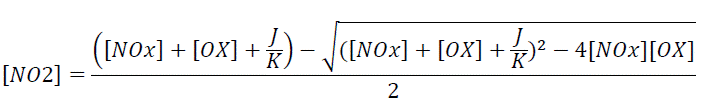
[NO2] = sum
of predicted NO2 concentration from all sources
[NOx]
= sum of predicted NOx concentration from all sources
[OX]
= sum of the NO2 concentration and O3 concentration
J
= photolysis rate of NO2
K
= the rate coefficient for
reaction between NO and O3
3.6.80 [OX] and J/K were derived from the analysis of
the recent 5 years of annual mean monitoring NOx, NO2 and O3
concentrations from relevant EPD’s AQMS. The details of the derivation and AQMS
referenced are shown in Appendix 3.10.
Prediction and Evaluation of Air Quality Impacts
during Operational Phase
3.6.81
The predicted air
quality modelling results have included the background pollutant levels as
extracted from the PATH model for year 2030 based on the PATH v3.0 model and
the cumulative impacts of the following emissions within the 500m Assessment
Area:
● Vehicular emissions from the road
networks within the Assessment Area (including project induced traffic);
● Identified industrial emissions from
Yuen Long Industrial Estate; and
● Vehicular emissions associated with
the existing bus terminus, bus depots, and car park with heavy goods vehicle
and coach.
3.6.82
Since there is no SO2
emission source contributed from the Project, the impact of SO2 from
surrounding sources is only considered upon Project ASRs. The worst predicted
cumulative air quality impact at representative ASRs is presented in Table
3.7. Detailed results are presented in Appendix 3.11. It can be seen
from Table 3.7 that the worst predicted cumulative results for RSP, FSP
and NO2 at all ASRs are well below their relevant AQOs. Also, no
exceedance of SO2 concentrations is predicted at Project ASRs.
3.6.83
Contour plots of the
cumulative pollutant concentrations at the worst affected levels are presented
in Figure 3.6A to Figure 3.6J for RSP, FSP, NO2 and SO2.
The worst assessment height for annual and daily RSP and FSP, annual NO2
and daily SO2 is 1.5m above ground. For 10-min SO2, the worst
assessment height is 9.2m above ground. For hourly NO2 the worst
assessment height is 10.0m above ground. Exceedance zones of daily and annual
RSP at 1.5m above ground, hourly NO2 at 10.0m above ground, and
10-min SO2 at 9.2m above ground and daily SO2 at 1.5m
above ground are observed in Figure 3.6A, Figure 3.6B, Figure
3.6E, Figure 3.6G and Figure 3.6H but no air sensitive uses
including openable window / fresh air intakes of the ventilation system or
recreational uses in open space are situated within the exceedance zones. A
site survey was conducted in January 2024 to confirm no air sensitive uses are
within the exceedance zones, at the corresponding assessment heights. In any
event, since exceedance zones are predicted, contour plots at levels above and
below those levels with exceedance zones have been plotted, as applicable,
until no exceedance zones are observed, and to confirm that no air sensitive
uses are located within exceedance zones. The additional contours plots are
presented in Appendix 3.12.
Table 3.7: Summary of Worst Predicted
Cumulative Modelling Results During the Operational Phase at Each ASR
|
ASR ID |
RSP |
FSP |
NO2 |
SO2 |
||||
|
10th highest 24-hour Average Concen-tration (μg/m3) |
Annual Average Concen-tration (μg/m3) |
36th highest 24-hour Average Concen-tration (μg/m3) |
Annual Average Concen-tration (μg/m3) |
19th highest 1-hour Average Concen-tration (μg/m3) |
Annual Average Concen-tration (μg/m3) |
4th highest 10-minute Average Concen-tration (μg/m3) |
4th highest 24-hour Average Concen-tration (μg/m3) |
|
|
Existing ASRs |
||||||||
|
A01 |
56.9 |
21.9 |
26.9 |
12.8 |
112.6 |
23.1 |
-- |
-- |
|
A02 |
62.0 |
26.6 |
29.2 |
14.7 |
93.0 |
23.7 |
-- |
-- |
|
A03 |
54.4 |
21.1 |
26.7 |
12.6 |
99.2 |
20.5 |
-- |
-- |
|
A04 |
54.2 |
21.7 |
26.9 |
12.9 |
101.4 |
24.8 |
-- |
-- |
|
A05 |
55.3 |
21.2 |
27.1 |
12.9 |
90.1 |
24.3 |
-- |
-- |
|
A06 |
53.6 |
20.7 |
26.6 |
12.6 |
89.4 |
18.1 |
-- |
-- |
|
A07 |
53.2 |
20.4 |
26.5 |
12.5 |
85.0 |
16.1 |
-- |
-- |
|
A08 |
53.1 |
20.3 |
26.6 |
12.5 |
87.6 |
17.2 |
-- |
-- |
|
A09 |
53.2 |
20.3 |
26.5 |
12.5 |
80.8 |
16.1 |
-- |
-- |
|
A10 |
53.1 |
20.2 |
26.5 |
12.4 |
78.3 |
15.0 |
-- |
-- |
|
A11 |
53.1 |
20.2 |
26.5 |
12.4 |
77.0 |
14.7 |
-- |
-- |
|
A12 |
53.2 |
20.3 |
26.6 |
12.5 |
83.9 |
16.4 |
-- |
-- |
|
A13 |
53.1 |
20.3 |
26.5 |
12.5 |
79.5 |
15.1 |
-- |
-- |
|
A14 |
53.3 |
20.6 |
26.7 |
12.6 |
90.1 |
17.7 |
-- |
-- |
|
A15 |
53.2 |
20.6 |
26.8 |
12.6 |
91.8 |
17.8 |
-- |
-- |
|
A16 |
53.1 |
20.3 |
26.5 |
12.5 |
78.6 |
14.9 |
-- |
-- |
|
A17 |
54.8 |
21.0 |
28.1 |
13.2 |
75.6 |
13.6 |
-- |
-- |
|
A18 |
52.3 |
20.0 |
26.4 |
12.3 |
74.1 |
13.2 |
-- |
-- |
|
A19 |
53.5 |
20.0 |
26.2 |
12.2 |
78.7 |
13.3 |
-- |
-- |
|
A20 |
53.5 |
21.2 |
26.9 |
12.8 |
100.3 |
19.6 |
-- |
-- |
|
A21 |
56.3 |
22.2 |
27.5 |
13.3 |
129.6 |
33.3 |
-- |
-- |
|
A22 |
54.2 |
20.5 |
26.5 |
12.4 |
82.9 |
14.4 |
-- |
-- |
|
A23 |
53.4 |
20.0 |
26.2 |
12.2 |
76.4 |
13.1 |
-- |
-- |
|
A24 |
56.3 |
22.9 |
27.4 |
13.4 |
142.3 |
28.6 |
-- |
-- |
|
Planned ASRs |
||||||||
|
C01 |
53.3 |
20.6 |
26.6 |
12.6 |
88.8 |
17.5 |
-- |
-- |
|
P01 |
53.7 |
20.6 |
26.4 |
12.4 |
87.2 |
15.6 |
109.8 |
24.8 |
|
P02 |
53.6 |
20.2 |
26.1 |
12.3 |
81.2 |
14.4 |
99.2 |
16.5 |
|
P03 |
53.2 |
20.5 |
26.6 |
12.5 |
82.2 |
15.7 |
122.7 |
19.9 |
|
P04 |
53.2 |
20.4 |
26.6 |
12.5 |
80.4 |
15.6 |
123.3 |
19.2 |
|
P05 |
53.2 |
20.4 |
26.6 |
12.5 |
81.3 |
15.6 |
110.4 |
20.4 |
|
P06 |
53.2 |
20.4 |
26.5 |
12.5 |
80.9 |
15.4 |
92.6 |
19.0 |
|
P07 |
53.2 |
20.3 |
26.5 |
12.5 |
80.0 |
15.2 |
99.0 |
16.7 |
|
P08 |
53.1 |
20.3 |
26.5 |
12.5 |
79.2 |
14.9 |
78.1 |
13.4 |
|
P09 |
53.2 |
20.4 |
26.5 |
12.5 |
80.2 |
15.2 |
95.4 |
17.5 |
|
P10 |
53.2 |
20.4 |
26.5 |
12.5 |
80.3 |
15.4 |
100.9 |
18.4 |
|
P11 |
53.2 |
20.3 |
26.5 |
12.5 |
79.1 |
15.1 |
97.2 |
15.6 |
|
P12 |
53.1 |
20.3 |
26.5 |
12.5 |
78.7 |
14.8 |
82.1 |
12.9 |
|
P13 |
53.1 |
20.2 |
26.5 |
12.5 |
78.6 |
14.7 |
74.1 |
11.9 |
|
P14 |
53.6 |
20.4 |
26.2 |
12.3 |
88.0 |
15.3 |
107.8 |
20.1 |
|
P15 |
53.2 |
20.5 |
26.6 |
12.5 |
82.2 |
16.0 |
115.7 |
22.1 |
|
AQOs |
100 |
50 |
50 |
25 |
200 |
40 |
500 |
50 |
Note:
Cumulative SO2 impact is assessed on
Project ASRs only, as there is no SO2 contribution from the proposed
Project.
Air Quality Mitigation Measures for Operational Phase
3.6.84
It has been assessed
that the predicted cumulative air quality impacts on all identified ASRs due to
industrial emissions; vehicular emissions from open roads, bus terminus, bus
depots and car park with heavy goods vehicle and coach; and background concentration
within the 500m Assessment Area would comply with the corresponding AQOs for NO2,
RSP, FSP and SO2. Therefore, no further mitigation measures for such
emissions during the operational phase are required. For the planned air-conditioned
visitor centre, no air sensitive uses including openable window/ fresh air
intakes of the ventilation system or recreational uses in open space (e.g.
sitting area) and any other air-sensitive uses of the proposed development
would be located within the 500m buffer from TOC, NH3, H2S,
styrene, ethyl benzene and dibutyl phthalate related emission sources, as shown
in Appendix 3.4. Otherwise, further assessment will be conducted during
detailed design stage to demonstrate no adverse air quality impact to the air
sensitive use of the planned visitor centre or any other air-sensitive uses of
the proposed development.
Evaluation of Residual Impacts for Operational Phase
3.6.85
During the operational
phase, it has been assessed that the predicted cumulative NO2, RSP,
FSP and SO2 concentrations at all ASRs due to industrial emissions;
vehicular emissions from open roads, bus terminus, bus depots and car park with
heavy goods vehicle and coach; and background concentration would comply with
the relevant AQOs. Hence, no adverse residual air quality impacts are
anticipated for the Project during the operational phase.
Environmental Monitoring and Audit Requirements for
Operational Phase
3.6.86
During the operational
phase, no ASRs are predicted to exceed the relevant criteria under the AQOs.
Hence, the EM&A programme for the operational phase is considered not
necessary.
Conclusions and Recommendations for Operational Phase
3.6.87
During the operational
phase, based on the cumulative results from industrial emissions; vehicular
emissions from open roads, bus terminus, bus depots and car park with heavy
goods vehicle and coach; and background concentration, it is concluded that all
the identified ASRs would be in compliance with the AQOs for daily RSP, annual
RSP, daily FSP, annual FSP, hourly NO2, annual NO2 and
10-minute and daily SO2. Hence, no adverse air quality impacts are
anticipated during the operational phase. For the
planned air-conditioned visitor centre, no air sensitive uses including
openable window/ fresh air intakes of the ventilation system or recreational
uses in open space (e.g. sitting area) and any other air-sensitive uses
of the proposed development would be located within
the 500m buffer from TOC, NH3, H2S, styrene, ethyl
benzene and dibutyl phthalate related emission
sources, as shown in Appendix 3.4. Otherwise, further assessment
will be conducted during detailed design stage to demonstrate no adverse air
quality impact to the air sensitive use of the planned visitor centre or any
other air-sensitive uses of the proposed development.
|
|
[1]
Environmental Protection Department, Air Pollution Control Strategies, June
2022 http://www.epd.gov.hk/epd/english/environmentinhk/air/prob_solutions/strategies_apc.html
[2] Environmental
Protection Department. Measurements and Validation for the Twelve-month
Particulate Matter Study in Hong Kong, 2022, Appendix A. (https://www.epd.gov.hk/epd/sites/default/files/epd/english/environmentinhk/air/studyrpts/files/final_report_mvtmpms_2022.pdf)
[3] PP-334/2007 - Tai Po Tai Wo
Road Sewage Pumping Station
[4] PP-371/2008 - Yuen Long Kau Hui No. 2 Sewage Pumping Station
[5] PP-068/1999 - Yuen Long South Sewage Pumping Station
[6]Pollution
Problems & Practical Solutions on Waste Handling & Refuse Room
https://www.epd.gov.hk/epd/english/greenproperty/poll_pro/popup_whrr_air.html#3
[8] https://www.legco.gov.hk/yr2023/english/panels/fseh/minutes/fseh20230404.pdf.
NCCO has already been adopted in various building in Hong Kong (https://www.rhtind.com.hk/ncco-air-cases). PDC
is also commercially available https://www.nami.org.hk/en/technologies/plasma-driven-catalysis-pdc-air-purification-with-downstream-disinfection-1
[9] Styrene Fact
Sheet, USEPA, https://www.epa.gov/sites/default/files/2020-05/documents/styrene_update_2a.pdf
[10] National Center for Biotechnology Information (2024). PubChem
Compound Summary for CID 3026, Dibutyl Phthalate, https://pubchem.ncbi.nlm.nih.gov/compound/Dibutyl-Phthalate
[11] Ethylbenzene
Fact Sheet, USEPA, https://www.epa.gov/sites/default/files/2016-09/documents/ethylbenzene.pdf
[12] Iowa State University Extension (May 2004). "The Science of Smell Part 1:
Odor perception and physiological response" (PDF). PM 1963a.
[13] Population
and Household Statistics Analysed by District Council District, 2023 Edition,
released on 5 April 2024.
[14] Yuen Long
Road Safety Centre mainly provide vehicle training for motorcycle, private cars
and light goods vehicles, whilst the training on medium goods vehicles and
buses is limited.