3.
HYDROLOGICAL IMPACT ASSESSMENT
3.1
Introduction
3.1.1
The
Sheung Shui to Lok Ma Chau Spur Line tunnel alignment passes under the Rivers
Beas and Sutlej and the agricultural land and wetlands within the Long Valley
area. This section of the report assesses the potential of the tunnelled Spur
Line to impact the groundwater both during construction and operation of the
tunnel. The section is divided as follows:
· assessment methodology and relevant legislation;
· description of surface terrain, watercourses and irrigation methods in the Long Valley area and their existing conditions;
· description of Long Valley geology and geotechnical parameters;
· concurrent projects
· assessment of construction and operational activities with their potential impacts;
· recommendations for mitigation measures; and
· assessment of residual impacts after implementation of mitigation measures.
3.1.2 Section 3 of the EIA addresses items 3.1 (i), (ii) & (iii) of the Particular Scope of the EIA, comprising:
(i)
the potential hydrological changes and the associated implications
for the ecology along the tunnel section during both construction and
operational stages;
(ii)
the monitoring of ground water levels and the contingency plan to
maintain the ground water levels; and
(iii)
the potential risks of ground surface settlement or heaving along
the tunnel section and the consequential impacts on the ecology.
3.1.3 The emphasis in the particular Brief relates to possible adverse ecological impacts as a consequence of lowering or interfering with the water table and Long Valley with its most critical ecological value is the focus of the study as a worst case. Elsewhere along the tunnel alignment neither the local ecology, the agricultural practices or the groundwater regime are as critical.
3.1.4 This section will characterise all the consequences of the tunnel proposal for the groundwater, both during construction and operations. The consequences and secondary effects of those changes to the groundwater regime, if any, will then be explored in the relevant chapters of the EIA.
3.2
Assessment Methodology
Hydrological Impacts from Construction and Operation of Spur Line
beneath Long Valley
3.2.1 This section describes the surface and sub-surface hydrological regime present within the Long Valley area and presents an assessment of the potential impacts from the construction of the bored tunnel using the Earth Pressure Balance Tunnel Boring Machine (EPB TBM) machine. Potential construction impacts due to tunnel construction are then described and mitigation measures presented, including monitoring programmes and contingency plans as required.
3.2.2 Modelling and observed performance of similar installations are used to characterise the likely operational impacts at Long Valley. The particular issues of concern for each phase are described below.
Construction Phase
3.2.3 The potential for adverse groundwater impacts during construction could take the following forms:
· Ingress of free water into the cutter head of the TBM during tunneling thereby drawing down the water table and adversely impacting the irrigation wells or draining ponds or watercourses;
· The perceived use of grouts or lubricants which could migrate away from the intended target and block an aquifer;
· Temporary loss of an aquifer because of ground freezing to facilitate the safe construction of cross-tunnels between the two tunnel tubes;
· Use of potential emergency measures, such as extensive blanket grouting or dewatering; and
· Ground settlement caused by the passage of the TBM sufficient to disrupt the surface hydrology.
Operational Phase
3.2.4 Perceived permanent impacts of the tunnels requiring assessment include:
· The potential for the tunnels to cause blockage or significant constriction of an essential acquifer, thus impairing the local groundwater regime; and
· The installed tunnel not proving to be fully watertight, thereby creating a need for constant pumping of leakage flows from within the tunnel, locally causing constant drawdown of the groundwater.
3.2.5
This
assessment is conducted in accordance to the EIA Ordinance, the Technical
Memorandum on EIA Process (Annexes 6 and 14), and the particular EIA Study
Brief. The Study Area, as specified in the Brief, is a corridor 300m to each
side of the Alignment. In Long Valley the area of search has been extended to
include the complete sub-catchment and agricultural unit bounded by the two
newly channelised rivers Beas and Sutlej and the Castle Peak Road to the south.
The potential effects of the Project on the surface hydrology and the
groundwater have been quantified where feasible. Worst case groundwater
assumptions have been used where reliable data is missing.
3.2.6
A
detailed survey of the surface hydrological features and irrigation practises
within the area has been presented and the possible effects that the passage of
the tunnel may cause in terms of distortion of that system has been discussed.
A sensitivity study has been used to ascertain the acceptable levels of
physical deformation that the watercourses and irrigation systems can tolerate.
An Action Plan has then been prepared to cover all eventualities.
3.2.7
A
detailed search of Government’s geotechnical database held by the Geotechnical
Engineering Office has been conducted. This information has been used in
conjunction with the substantial KCRC ground investigation information
recovered during two phases of field work and laboratory testing. The
information recovered has been used to characterise the hydro-geological regime
for the purposes of carrying out a worst case two-dimensional finite element
analysis to predict the consequences on groundwater movement of placing the
twin tunnels in the Long Valley sub-strata.
3.2.8
Ultimately,
the purpose of the surveys and assessment is to ascertain the likely impact of
the presence of the tunnel on the groundwater regime in Long Valley during
construction and operation. The study seeks to identify any tunnel induced
additional variations in the groundwater cycles that could have an adverse
impact on the ecology. The ecological assessment of the consequences of any
additional variations to the hydrology identified is carried out in Chapter 4
of this EIA.
Relevant Environmental Legislation
3.2.9
The Buildings Ordinance makes provision for
control of groundwater levels with respect to construction of foundation
structures and the use of re-charge wells, if applicable. Legislation also
exists to control direct groundwater abstraction with respect to karstic
features throughout the territory. However, the gazetted areas in the NWNT
prohibiting groundwater abstraction do not extend to within the footprint of
the Spur Line or its mitigation areas.
3.2.10
Direct
abstraction of groundwater is not required for the purposes of constructing the
tunnel or its approach structures. Upon completion, excavation and dewatering
will take place within the tunnel launch and retrieval boxes and the approach
ramp structures. Any influence on the local groundwater outside the structure
as a consequence of such works is controlled under the Buildings Ordinance.
3.2.11
From a
Waterworks Ordinance standpoint, the
eastern half of the Railway (Sheung Shui to Pak Shek Au) falls within a
designated “flood pumping catchment area”. For development within the area, the
EPD is the sole authority for imposing water quality standards and the checking
of detailed drainage/sewerage proposals. Abstraction of groundwater within Long
Valley for irrigation purposes has long been practised by the local farmers and
is tolerated from a Waterworks standpoint. There is no provision under the
Waterworks Ordinance to restrict such water abstraction.
3.2.12
Both
Government and Private sector projects occasionally use groundwater sources for
the maintenance of flushing water requirements. Wetland recreation requiring
groundwater abstraction was proposed for the original Spur Line viaduct scheme
across Long Valley. Wetland re-creation in Long Valley is not required under
the latest scheme. Substantial wetlands will be re-provisioned at Lok Ma Chau
under the latest proposals, but no groundwater abstraction is proposed to
maintain those wetlands. Collection and management of the natural rainfall will
be used to meet the water demands of the proposed Lok Ma Chau wetlands, which
reflects on-going fish culture practice in the area
3.3
Existing Usage and Sensitive
Receivers
3.3.1 As required in Clause 3.9.3(v) of the Study Brief, the existing surface water and groundwater regime needs to be characterised to assess potential impacts from the construction and operation of the Spur Line project.
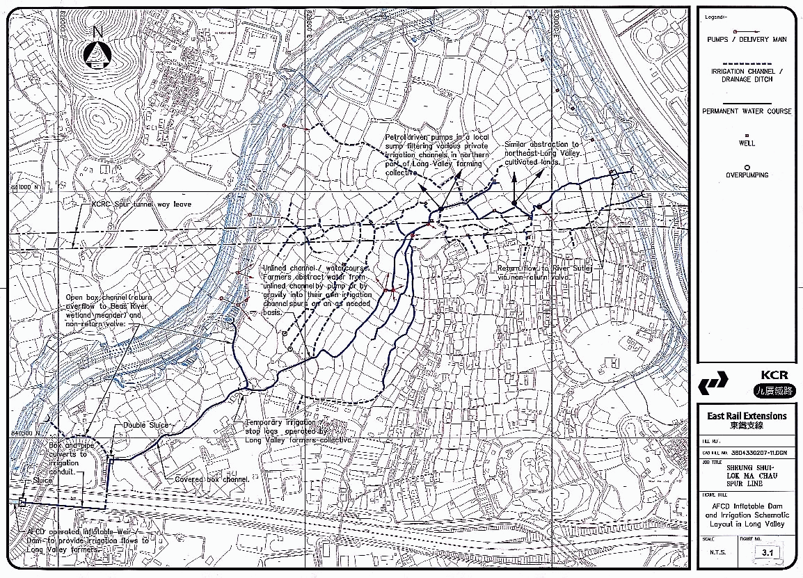
3.3.2 The topographical and surface hydrological character of Long Valley is shown in Figure 3.1. The Valley has long been the subject of annual flooding events being located at the confluence of the Beas, Sutlej and Indus Rivers which drain one of Hong Kong’s largest natural catchments of some 70 sq. Km. Flooding in Long Valley regularly reached depths of more than 2m with the passage of significant annual storm events.
3.3.3 In 1999-2001, the Rivers Beas and Sutlej were formally channelised with confining bunds that are typically 2 to 3 m higher than the pre-existing floodplain. As a consequence, the direct catchment in Long Valley has now been reduced to about 80 ha as delineated by the new Beas and Sutlej (including Tsung Pak Long channel) river channels and the New Territories Circular Road to the south. The subsurface catchment still remains very much larger by virtue of the buried quarternary flood plain deposits and river channels as discussed in Appendix A3.1.
3.3.4 The frequency of major flooding events in Long Valley will thus be much reduced. However, in a major territory-wide rainstorm event, local flooding, particularly in the northern end of Long Valley can still be expected, albeit to a lesser extent. Runoff from the new Long Valley sub-catchment will be confined behind the main river channel walls pending the opening of the non-return valves in the channel bunds. These non-return valves prevent the much larger storm flows in the main channel from flooding Long Valley, but only open when the water levels in the main channels have subsided sufficiently to allow the discharge from Long Valley.
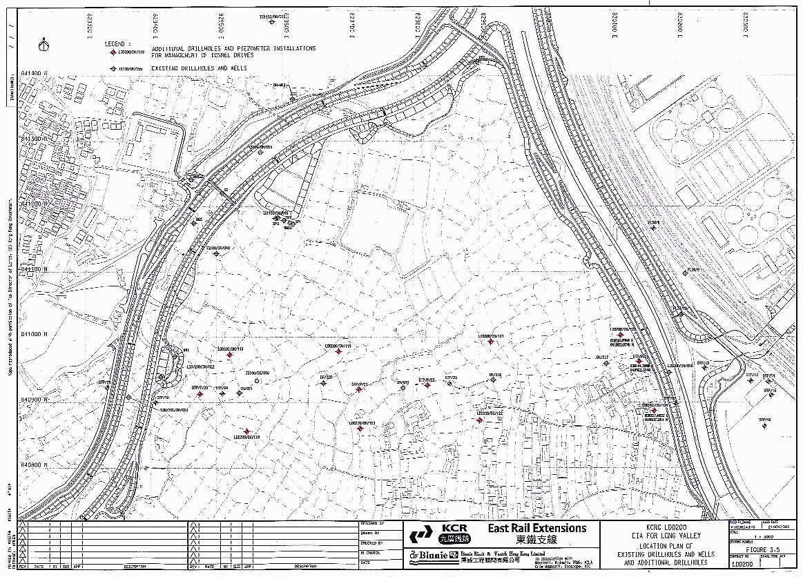
3.3.5 In the dry season and to a lesser extent in the summer, the agriculture in Long Valley is sustained by various types of irrigation dependent upon the proximity of each agricultural lot to the various watercourses. Hand dug wells and normally dry irrigation channels are also used to meet irrigation needs. The surface features close to the proposed tunnel alignment are shown on Figure 3.1 This figure should be read in conjunction with the photographic plates presented in Figures 3.2, 3.3 & 3.4.
3.3.6 The photographs provide a complete record of the means by which the Long Valley farmers source their irrigation water supply from the River Beas and groundwater and show the typical means by which these flows reach the target crops. The residual flows are returned to the main drainage system at the River Sutlej. (See Figure 3.4, Plate 3.20) The arrangements for operation of the various means of irrigation supply require some consensus amongst the individual farmers and vary from year to year to reflect seasonal and commercial factors.
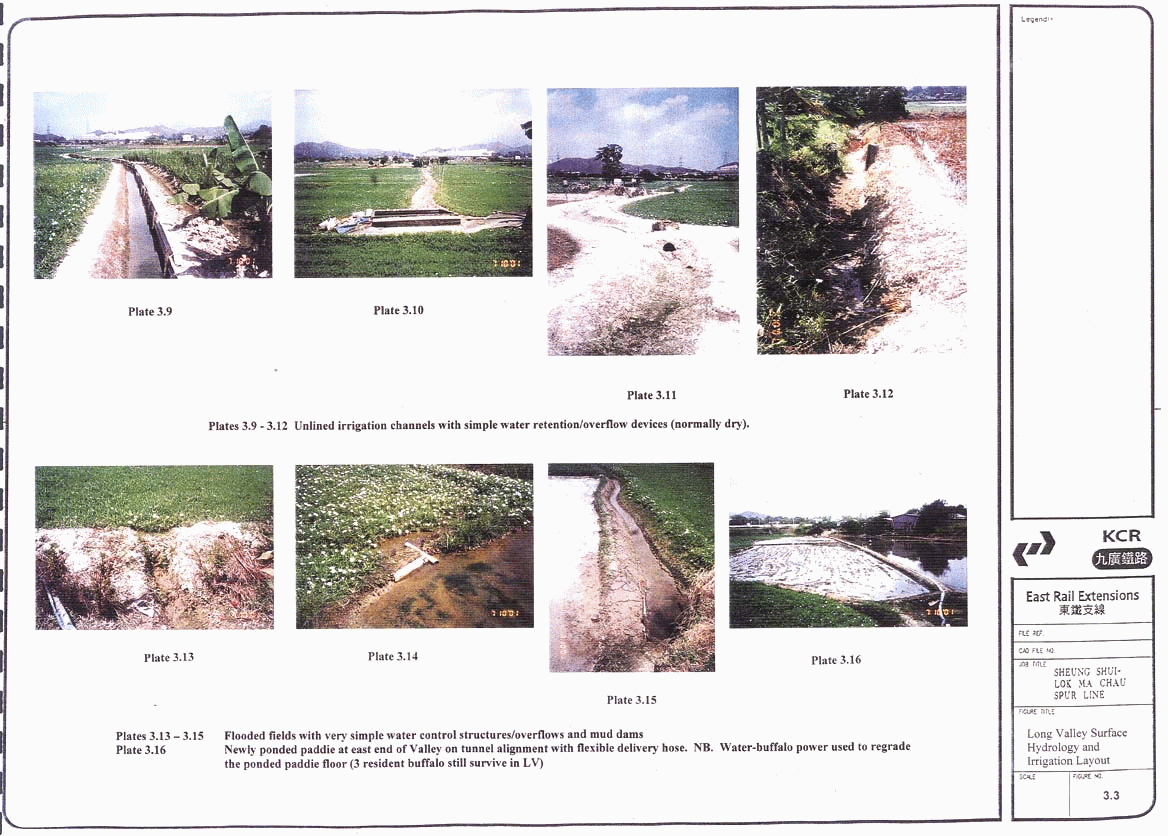
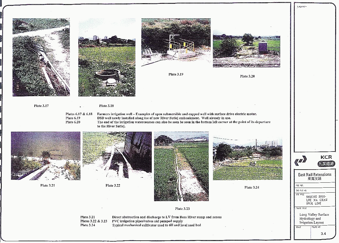
3.3.7 The farmers’ irrigation practices traditionally comprise intermittent pumping from the main surface channels traversing the valley floor (See Figure 3.2, Plates 3.5, 3.7, 3.8) and occasionally from their own hand-dug wells (See Figure 3.4, Plates 3.17, 3.18 & 3.19). Irrigation flows are then conveyed by gravity feed along open earthen irrigation channels (See Figure 3.3, Plates 3.9 to 3.12 inclusive) or via local network of small diameter UPVC pipes laid in or alongside the same bunds (See Figure 3.4, Plates 3.22 and 3.23). In some cases the final 10 – 20 metres of irrigation water is delivered via collapsible hose (See Figure 3.4, Plate 3.16).
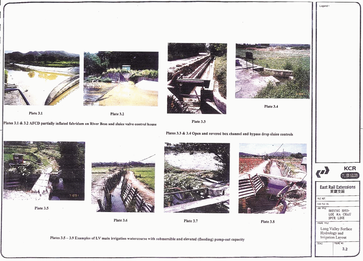
3.3.8 In the dry season, continuous flow in the main surface channels across Long Valley is promoted by the AFCD inflatable irrigation weir, drawing more nutrient rich waters from upstream in the River Beas, immediately south of the NT Circular Road. (See Figure 3.2; Plates 3.1, 3.2)) The weir diverted flows are delivered to the main stream course in the middle of the valley ( See Figure 3.2 Plate 3.6) by a system of pipe culverts and open and covered box channels with stop logs operated in consensus by the farmers.(See Figure 3.2 Plates 3.3 & 3.4)
3.3.9 Prior to the recent channelisation of the Rivers Beas and Sutlej by Government, the farmers also irrigated directly from these two naturally meandering rivers. Provision has been made in the River Beas for the continuation of this practice using staircases and sumps fed from the low flow channel. (See Figure 3.4, Plate 3.21)
3.3.10 On the east side of Long Valley, the loss of access for irrigation purposes to the re-aligned River Sutlej has been compensated by the provision of 6 No 1.2m diam. pumping wells, typically at 75m centres along the toe of the new embankment, outside the lower access track. (See Figure 3.1 & 3.4, Plates 3.19 & 3.20)
3.3.11 Farmers whose land borders the channel are actively using these new pumping point facilities with simple submersible pumps. Farmers whose lots do not have direct frontage, use a local network of small diameter plastic water pipes that have been dug into the bunds and footways and connect to the new wells and pumping points.
3.3.12 Irrigation water, from whatever source, is delivered to the individual field plots and can be conveyed to cascade sequentially to flood a suite of plots. The earthen bunds between each plot are typically only 300mm high and a hydraulic connection between adjacent plots is formed usually with a 50 – 100mm diam plastic pipe stopped with a simple cap, plug or bung. See Figure 3.3 Plates 3.13, 3.14 & 3.15). Inter-plot bunds are often simply breached to effect filling or drainage and the earth plug restored The day to day management of the water resource requires some consensus amongst adjacent plot holders, but the methods used are traditional, simple and flexible allowing the transfer of water to suit day to day cropping and fallow requirements.
3.3.13 Groundwater levels in Long Valley vary through the year with respect to season, tide and local abstraction for irrigation purposes. In the case of extreme wet conditions, after the passage of any of the floods that will saturate the whole valley, the water table will reach ground level for a short period, i.e. typically 3.5mPD. At the end of the dry season the lowest normal water levels could reach the mean of the tidal range, i.e. typically 1.5mPD. Readings from existing piezometers show a lesser range of values i.e. between +1.6 and 2.6m PD. In the centre of the valley, the constant flow along the main irrigation watercourse (driven by the AFCD dam) and direct pumping to the surrounding plots can sustain groundwater at typical levels of 3.1 to 3.3 m PD as measured in Bore hole LDD-200/DH020. Interviews with the farmers reveal exceptional events amongst the farmers’ wells where continuous daily pumping for irrigation purposes has locally lowered the immediate groundwater to more than 4 m below ground level, i.e. typically –1.0m to zero m PD. In some cases the farmers have reported wells that can be pumped dry over one day of submersible pump usage but this could also reflect a locality where the underlying aquifer, the alluvial stratum, is not continuous.
3.3.14 Traditional well excavation by the farmers is a hit and miss affair, with siting dictated more by land tenure rather than any scientific approach to finding an available aquifer. Wells are hand dug to sink pre-cast concrete rings. The well dig terminates at a depth where the upwelling groundwater renders further hand digging unsafe. Successful wells are regularly used and poorly performing ones are either abandoned or are only infrequently used as water storage vessels.
3.3.15 The agriculture in Long Valley and the seasonal wetland characteristics of occasional fallow areas are dependent upon maintaining the groundwater levels. Whilst the irrigation aspect can be serviced from several alternative sources, the possible influence of the KCRC tunnel proposal will need to be considered and if necessary any unacceptable adverse impact will need to be mitigated.
3.4
Long Valley Geology and Hydrogeology
3.4.1 The geological and hydro-geological condition along the Long Valley tunnel alignment is discussed in detail in Sections 5 & 7 of Appendix A3.1 and can be summarised as follows:
3.4.2 The geology of Long Valley between the confining Rivers Beas and Sutlej watercourses comprises Pleistocene and Holocene alluvial deposits overlying Mesozoic completely weathered tuffs and tuff bedrock of the Tai Mo Shan formation. The main aquifer is the alluvial sand & gravel deposits varying from 1 to 8 m in thickness. The main aquifer is capped by less permeable alluvium comprising well to semi-sorted clays and silts. Some fills, pond and estuarine deposits overlay this upper alluvium. The main aquifer is underlain by completely decomposed ash Tuff, varying from 9 to 40 m thick.
3.4.3 The completely weathered Tuff is the target for the tunnel drive, particularly because of its uniformity and suitable strength characteristics. Also, its permeability is low, being some two orders of magnitude less permeable than the main alluvial aquifer.
3.4.4 Analysis of all the available borehole and soil testing information has given rise to the following mean characteristic parameters based on geometric means (Table 3.1).
3.4.5 These data form the basis of the steady state SEEP/W model analysis that is discussed in detail later in respect of the predicted permanent impacts of tunnel installation on the groundwater regime.
3.4.6 The initial overview of the geology within the valley indicates the likely dominance of the main alluvial aquifer in the groundwater regime. The drawdown and recharge performance of most of the farmers wells in Long Valley which were all shallow gave further weight to this view. Notwithstanding, the very large catchment for the two rivers and the general topography of the surrounding hills implied that the potential existed for some mild artesian condition. However, the likely contribution of such groundwater rising from the tuff bedrock through the much less permeable CDTuff was considered to be of second order magnitude and the possible contribution to the overall groundwater regime was ignored for the purposes of the study. The study and the planned additional SI focussed on the main alluvial aquifer.
3.4.7 The preliminary data from the additional SI confirm the dominance and the persistence of the coarse grained alluvial Sands and Gravels across the full extent of the valley floor. The minimum thickness of the coarse phase is 2m and the average thickness across all 13 drillholes is 3.9m. The interface between alluvial and CDT across the valley lies between –1.0 and –3.20 m PD. The coarsest sands and gravels are to be found at the bottom of the stratum. This new information when viewed with all the other ground data gives great confidence in the continuity of the main alluvial aquifer throughout Long Valley and with the exception of the River Sutlej area, the absence of deep buried former river channels which might be intersected by the tunnel drive. At the Sutlej, where the depth of the whole alluvial stratum varies from 6 to 8.5m, the tunnel designer has both the EPB tunnelling machine and the deep stabilised block in the current river bed to ensure that the groundwater table is protected.
3.4.8 Concern has been expressed by the public that the Long Valley tunnel could cause unacceptable settlement problems similar to those associated with another recent tunneling scheme. Recent problems with deep tunnelling at Tseung Kwan O have shown very significant problems with groundwater drawdown into the fractured bedrock. The effects of the drawdown have further compounded with changes in effective stress in soft compressible stratums which have caused substantial surface settlements. The comparatively shallow depth of the rail tunnels in Long Valley(typically 15m rather than 150m at TKO), the use of the Earth Pressure Balance TBM to control groundwater during construction and a fully waterproofed permanent tunnel lining will ensure that such problems are not repeated in Long Valley. As a consequence, no in depth analysis has been undertaken of the properties of the weathered and parent rock within the Valley.
3.4.9 It is recognised that faults and discontinuities in the bedrock and the relict structure within the weathered phases through which the tunnels are to be driven may have some significance for the tunnel designers and all new ground information has been made available to them. However, it is not realistic that these relict features or the local severance of such features by the impermeable tunnel are likely to lead to a change in the surface or near surface hydrology. The properties of the underlying bedrock will therefore not be further discussed in this section.
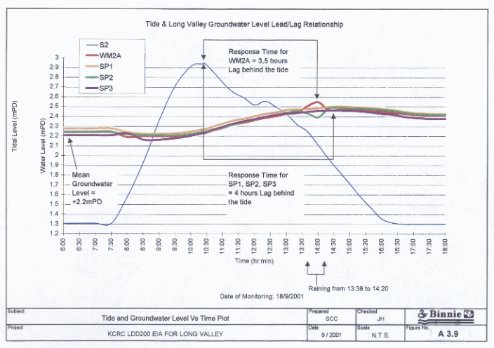
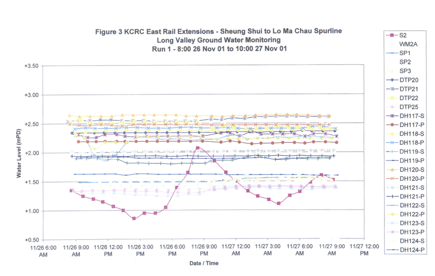
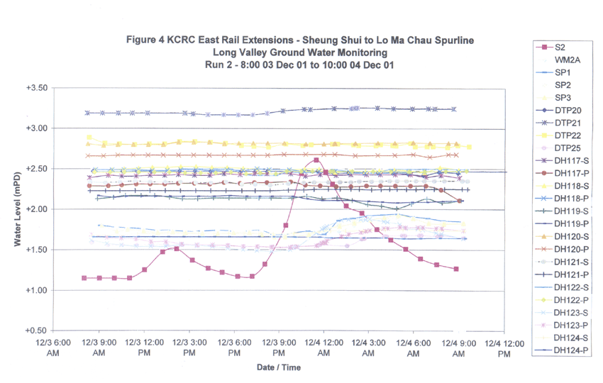
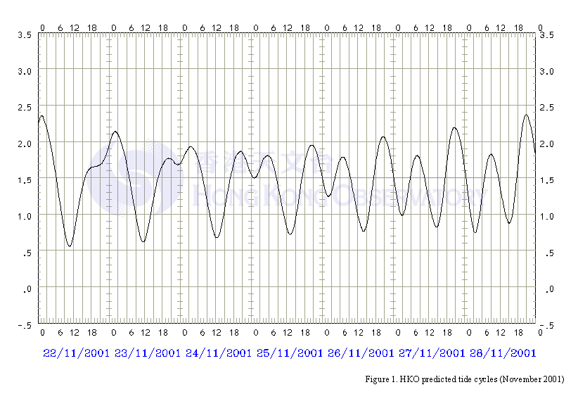
3.4.10 In addition to a review of the bore hole and laboratory soils data, a study of the local groundwater relation ship with tidal variation has proved possible using piezometric equipment installed during KCRC’s original investigation. The measured response of the Long Valley groundwater to a wet season Spring tide event is given in Appendix A3.1 Figure A3.9. An additional definitive dry-season record has still to be run using the latest peizometers installed in October 2001 to define the Spring and Neap tide relationship when ambient groundwater levels are lower. The preliminary results of the 26/27 November (Neap) and 3/4 December (Spring) monitoring events are summarised in Appendix 3.2 Figures 3 and 4. A definitive wet season Spring and Neap tide will also be run in the Summer of 2002 to complete the latest GI work.
3.4.11 Currently available wet season piezometric data clearly shows that as soon as the tide level rises above the prevailing groundwater level in Long Valley, a similar upward response in the groundwater level in the main alluvial acquifer commences. However, there is a significant time and amplitude lag in the piezometric response. For the location monitored, some 85 to 110m inland, the tidally driven peak in groundwater level is reached up to some four hours after the actual tidal peak occurs in the river. Also, the total rise in groundwater level is less than 50% of the difference between the absolute tidal peak and the ambient groundwater level preceeding the tidal event.
3.4.12 The magnitude of the groundwater response to tidal variation in the centre of the Valley has still to be proven and fieldwork has been carried out in the Autumn 2001 and monitoring will continue throughout the next dry and wet season. The preliminary findings of this work are presented in Appendix A3.2. The preliminary inspection shows a measured range of variation in groundwater levels in the middle section of Long Valley within the immediate vicinity of the tunnel alignments of up to 1.5m over a 10 day period. Closer to the main river channels the measured variation in groundwater levels is typically half that measured in the centre of the valley for the same period. These dry season readings were taken over the Neap and Spring tide cycles in an effort to gauge the tidal influence. The exercise proved to be partially frustrated by new cofferdam works in the combined river channels to facilitate the final re-connection of the River Indus. This cofferdam limited the expected differential in the tidal levels. Other influences on the groundwater level variation in the middle of the valley include: Temporary deflation of the AFCD dam in the River Beas and replacement by a single pump to re-direct the irrigation flows; Direct flooding of several plots along the alignment either by secondary abstraction from the irrigation channel or by direct pumping from the main river or by pumping from several of the wells in the vicinity. All these aspects will have contributed to the measured variation in groundwater levels. At DTP 21, the basal influence/difference between water levels is believed to still reflect the mean ground water levels for the two sets of tides. However, the main influence is likely to be the contribution from the irrigation watercourse and from the pumped flooding of various agricultural lots. This water percolates down to top up the water table locally. The groundwater regime in the centre part the valley is dominated by the irrigation channel and the amount of water being directed through from the AFCD weir. It is further affected by lateral irrigation activity by pumping and ponding / well recharge and the duration thereof. Negatively it can be affected by pumped drawdown from other adjacent wells. A greater understanding of the tidal influence will be sought when the Beas / Sutlej channel works are complete. A definitive dry-season baseline will still need to be taken in early 2002, when some of the on-going construction factors can be eliminated .
3.4.13 These same 13 installations will also be used to monitor baseline wet and dry season groundwater levels prior to the tunnel drives and thereafter during and after tunnel construction.
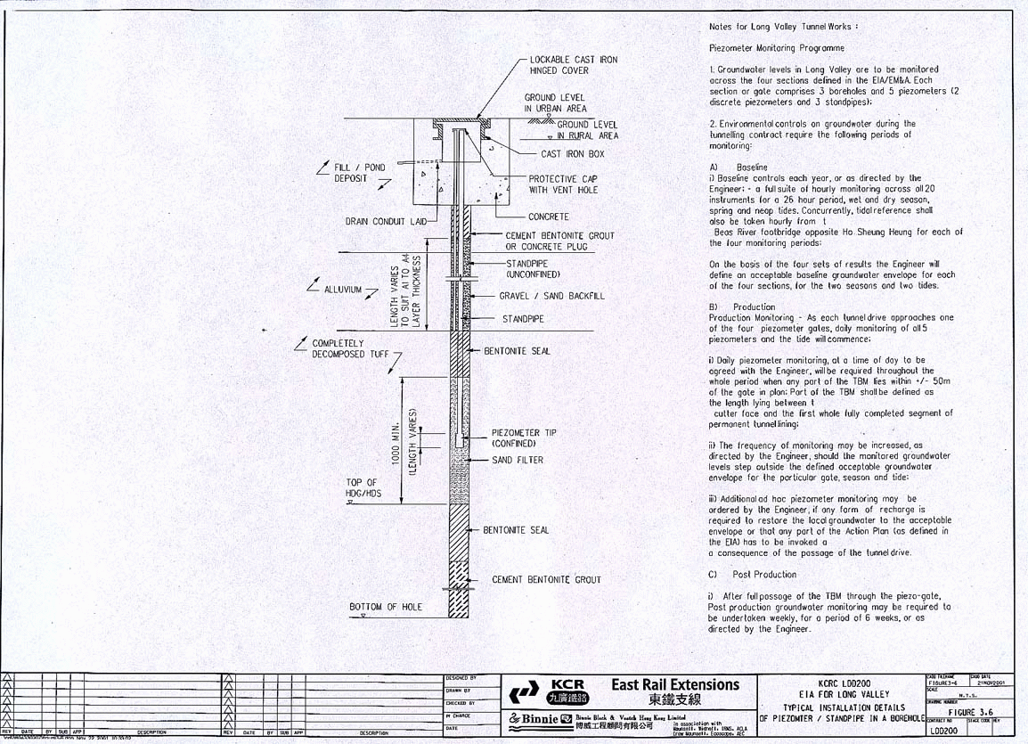
3.4.14 The layout of the piezometers within Long Valley is shown in Figures 3.5 & 3.6. The piezometer monitoring regime to manage the progress of the twin tunnel boring is shown in Figure 3.6.
3.5
Concurrent Projects
3.5.1 In respect of the variations in the groundwater regime within Long Valley, there are no known concurrent construction projects expected during the period of the tunnelling construction.
3.5.2 The most recent and major work in the area, the channelisation of the Rivers Beas and Sutlej is essentially complete at the time of drafting the EIA and the rivers have been restored to normal tidal operations. The downstream inflatable dam at Orb Hill has been fully reprovisioned and its operation will revert to WSD as a flood impounding device. Whilst the hydraulic functions of the new watercourses are fully functional, works are still continuing on general landscaping, lighting, access roads and paths. These works are programmed to be completed in early 2002.
3.5.3 The next phase of the Shenzhen River widening scheme, Stage 3, is likely to be underway well to the north of Long Valley, but the consequences of various local impounding or dewatering at Lo Wu in Stage 3 of that project, are too remote to adversely impact the groundwater in Long Valley.
3.5.4 The Fanling Bypass project, as currently conceived, lies outside the defining bunds of the newly channelised Rivers Beas and Sutlej with respect to the heart of Long Valley. The planned construction of the Bypass is linked to the development of the Kwu Tung North NDA which is expected to follow the construction of the Railway.
3.5.5 During the latest period of ground investigation by KCRC and the study for the EIAs, the channelisation of the Rivers Beas, Sutlej and Indus has been on-going. The channel construction works are normally constructed using local bunds immediately up and downstream of the particular area of works together with pumping out of groundwater between the two. The up and downstream inflatable dams operated for AFCD and WSD respectively have also been the subject of temporary controls and re-commissioning trials. These have variously caused either temporary local impounding, artificial lowering of the groundwater and/or compensation pumping. All these temporary conditions have had to be recognised and accommodated in the findings of the study of the surface irrigation flows and the valley groundwater during the 2000/01 period for this and the earlier EIA. The two well point tests carried out for KCRC in early 2001 and various periods of piezometer reading have been influenced by these temporary conditions.
3.6
Assessment of Construction and Operational Activities, their
Potential Impacts and Mitigation Measures
Potential Tunnel Construction Impacts on Groundwater and Design
Mitigation
3.6.1 The bored tunnel drives will extend from the launching shaft at Sheung Shui through to the reception shaft at Chau Tau. Almost all of the drives will be through Volcanic Tuff bedrock or various stages of weathering thereof. In Long Valley the tunnel will mostly be in Completely Decomposed Volcanic Tuff (CDV)). The tunnel drives have been designed to run almost exclusively through the weathered rock well clear of the main alluvial acquifer. The CDV has relatively low permeability, at least 2 orders of magnitude less permeable than the comparable main alluvial aquifer above. The TBM drive only breaks into the main aquifer at the very east end of Long Valley as it passes under the channelised River Sutlej.
3.6.2 The weathered rock is well suited for the TBM to be operated in “Earth Pressure Balance” (EPB) mode. In the event that the drive should unexpectedly encounter a deeper buried former river channel or achieve a direct connection to the more permeable alluvial stratum, the tunnel drive in EPB mode can continue without stoppage or risk of drawdown of the groundwater. In Long Valley, the proposed EPB mode will be adopted throughout the drive to ensure that there is no drawdown or adverse impact to the groundwater.
3.6.3 In EPB mode, the TBM is equipped with a lockable full pressure bulkhead some 3m back from the cutter face to balance inflow of saturated boring debris against the measured progress of the drive and the quantity of ground up detritus removed from the chamber. This pressure is maintained by continuous advancement of the TBM by jacking against the completed tunnel lining, constantly being erected immediately to the rear. The spoil is removed through a long archimedian screw conveyor passing through the TBM bulkhead, the rate of rotation of which is precisely controlled to maintain the necessary pressure in the chamber. Thrust, torque, pressure and spoil weight in the cutter chamber are all controlled in real time by on-board computers. This sophisticated and continuous monitoring regime allows the TBM pilots to ensure that there is no over-excavation, that a continuous balance of pressures in the cutter chamber is maintained and that no ingress of free water from the surrounding ground occurs. Equally, with a relatively incompressible saturated spoil and no free air, the EPB ensures that no over pressurisation and expansive blow-out to the surface can occur.
3.6.4 Earth Pressure Balance technology is relatively new to Hong Kong, but is well proven elsewhere in Asia with some 16 major examples in the last 20 years. Notable recent large diameter EPB examples driven through water bearing alluvial strata are shown in Table 3.2
3.6.5 Substantial lengths of the Channel Tunnel were driven using EPB technologies and most recently an EPB machine has been used very successfully to bore a railway tunnel beneath the River Thames in UK, with little cover to the actual river bed. EPB systems were adopted expressly to guard against uncontrolled water intrusion from expected scour holes within the river bed which have infilled with granular materials and with direct hydrostatic connection to the river waters.
Hydrological Impacts during Construction
3.6.6 During the Long Valley operation, there is a potential for impacts on both the underground water resource and surface watercourses:
3.6.7 As the tunnel boring machine passes through the weathered material below Long Valley, there is a potential for groundwater to enter the tunnel as the cutter head moves through the saturated weathered rock. This potential impact is minimised, firstly by design in selecting a vertical alignment which is typical half a tunnel diameter beneath the main acquifer and secondly through the provision and operation of a TBM designed to be operable in Earth Pressure Balance Mode (EPB TBM),
3.6.8
In Long Valley, with the TBM in EPB
mode and passing through the much less permeable weathered rock phase, than the
main alluvial aquifer, any change in groundwater levels would be expected to be
very slight. The main water bearing stratum is deep and extensive and would be
reasonably expected to replenish any local water losses from a very large
surrounding area. However, no prospect of any drawdown of groundwater will be
entertained. An intensive approach to the monitoring and management of
groundwater is proposed as set out below. Clause 3.1 (ii) the monitoring of ground water levels and the contingency plan to
maintain groundwater levels and 3.9.3(vii) of the Brief requires the establishment of the monitoring of
ground water levels and a contingency plan in case of draw down of water table
during construction and operation of the tunnel section in particular at Long
Valley.
3.6.9 KCRC have installed 4 suites of 5 piezometers each across 4 representative sections within Long Valley. This extensive instrumentation has been proposed in order to establish an accurate baseline of the groundwater regime prior to tunnelling and to put in place adequate monitoring and reliable action plans for the tunnelling process with respect to the groundwater issue. This work was undertaken in conjunction with the exploration bore holes in October/November 2001. These are shown in Figure 3.5 and typically comprise at each section;
3.6.10 The standpipe piezometers reflect the performance of the main alluvial aquifer from which some of the irrigation waters are regularly drawn. The standpipes aggregate the available water and the variable permeabilities within the alluvium, which ranges from stiff clay to open cobbles. The various piezometers will establish a year long groundwater baseline prior to commencement of tunneling. This baseline will vary seasonally and respond daily to tidal variations in the two adjacent river channels.
3.6.11 The preliminary results of the first dry season neap and spring tide monitoring events are given in Appendix A3.2.
3.6.12 All the piezometers will be used routinely to monitor and manage the effects of the passage of the TBM. The predicted consequences on the groundwater are given below and the details of an Action Plan to deal with any eventuality are provided. The actual baseline, production and post production piezometric monitoring regime to control the work is shown in Figure 3.5 & 3.6. The Long Valley piezometric baseline survey will characterise an envelope of typical variation in groundwater levels induced by seasonal, tidal and anthropogenic factors (irrigation demand). An acceptable operating groundwater envelope will be defined for the project with respect to wet/dry season and Neap or Spring tides. In the event that water levels do locally fluctuate beyond the acceptable envelope with the passage of the TBM, the Action Plan will prescribe the means of recharging the aquifer. The action plan will ensure that the water needed to sustain the surface irrigation system and the agriculture is readily available and ensure that the fallow wetland maintains its ecological function.
3.6.13
No significant groundwater draw down
in Long Valley is expected during the tunneling operations. Adequate
piezometric monitoring and a defined recovery plan are available in the
unlikely event that an exceedance does occur.
3.6.14 The passage of the TBM cutter head which is very slightly larger in diameter than the main body, coupled with the design geometry of the lining segments as placed, leaves a small annular void which has to be grouted. A stone-fines/lime mortar is injected into this void immediately after the placement of the tunnel lining segments. The consistency and penetration of this external annular mortar grout as observed in the similar Contract DB320 crossover hand excavations is 100 to 150 mm and no penetration into the surrounding soil fabric was visible. The completed grout ring will not interrupt the performance of any aquifer.
3.6.15 A biodegradable and non-toxic foam and additional water are injected into the cutter head in EPB mode to facilitate the breakdown of the materials arising from the TBM operation. The product of this activity does not gel and is brought back into the tunnel spoil disposal stream. There is thus no prospect of it passing beyond the cutter head to possibly impair an aquifer outside the drive.
3.6.16 The normal means of operating the TBM occasionally requires a full check of the cutter head and replacement of worn cutter discs, particularly prior to encountering rock or transition zones in the tunnel excavation. It is normal to use bentonite re-caking to ensure that the excavation face is stable during such manned interventions. Short inspection interventions will be used for routine maintenance disc changes and bentonite caking of the excavation face will be used. Resumption of boring will pull all the bentonite cake back into the tunnel spoil and no bentonite losses to the aquifer are expected. No interventions are expected in the first 800m of the drive under Long Valley as the TBM will be newly refurbished prior to each Long Valley crossing.
3.6.17 Within Long Valley three operational emergency cross-over passages are to be constructed between the two tunnels. Ground freezing will be used to secure the excavation of these passages, launched from one side of the completed tunnel into the path of the other tunnel. Jet grouting from the surface which is normally used to secure such works will not be permitted in Long Valley. In the unlikely event that the integrity of the freezing method is compromised during the hand-dig of the crossover passage, a compressed air default method will be available. Neither freezing nor compressed air offers any risk of permanent blockage to any aquifer. Temporarily, the lateral extent of the frozen block is unlikely to inhibit groundwater movement in the main alluvial aquifer.
3.6.18 Total failure of the drive and recovery from the surface of a lost TBM requiring the construction of a sheet pile box is a rare event. Such stoppages when they occur, are usually related to either unforeseen ground conditions or man made obstructions. Such man-made obstructions can include abandoned heavily reinforced bored piles from a former foundation system or a buried rock-fill seawall. Natural features such as core stones can be bored through even if intervention from within the TBM is necessary to renew cutter discs. However, large core stones are not a feature of the CDV to be found under Long Valley.
3.6.19 The ground conditions in Long Valley between the two rivers are natural except for some hand-dug wells near the surface. No other form of development or major structure has existed on the tunnel alignment. Such mixed conditions (part bedrock, part weathered rock) as may be found within Long Valley are fully within the remit of the tunneling machine. The Long Valley ground conditions are less challenging than those encountered during the DB320 drive which was successfully completed without incident. Upon completion of the DB320 contract, the TBM equipment has been fully refurbished with fundamental features such as main shaft bearings completely renewed. With both tunnel drives under Long Valley originating from the launching shaft immediately east of the River Sutlej, the prospect of breakages due to wear and tear are also removed.
Summary of Temporary Groundwater Drawdown Issues
3.6.20 Long Valley is not considered to be as challenging a tunnel drive as the DB320 task and there is no realistic risk of any major failure requiring a coffer dam and surface intervention. Groundwater and irrigation water supply is secure and hence there is no danger of a significant impact on the flora and fauna. However, notwithstanding the confidence with which this prediction is made, it is recognised that the ultimate “What if?” scenario must still be considered. Even a very worst case scenario can be accommodated with confidence.
3.6.21 In the unlikely event that there should be some temporary groundwater loss during construction there are a significant number of simple actions that can be taken to overcome any deficit to ensure that no adverse impact ensues either to the agriculture or the natural environment. Dependent upon the duration and degree of change of the groundwater levels, the actions needed to recover the situation can be summarised as set out in Table 3.3. Both pre-emptive and re-active actions are prescribed. Simple and pragmatic solutions are available to ensure that no significant adverse impact can affect either the fallow wetlands or the agricultural practices even in the event of a catastrophic failure of the tunnel drive.
3.6.22 Ultimately, the downstream fabridam could be used temporarily to maintain a constant high water level and flood the main alluvial aquifer to within a metre of the ground surface across the whole of the floor of the valley. This could create an artificial groundwater table up to 0.5m higher than the normal highs in the measured groundwater regime under dry conditions when the dam is not inflated..
3.6.23 Surface settlement as a consequence of the passage of the TBM beneath has potential to disrupt the surface drainage system and interfere with the hydrology. Item 3.1 (iii) of the detailed scope for the Brief calls for examination of the potential risks of ground surface settlement or heaving along the tunnel section and the consequential impacts on the ecology. Also, Clause 3.9.3(vi) of the Study Brief requires an assessment of the risks of ground settlement or heaving especially in the wetland areas and the need for compensation grouting and its impacts on the water systems. The predicted settlement or heave prospects are reviewed below. The likely effects on the ecology stem from the potential of either heave or settlement to adversely impact the surface water supply.
3.6.24 The possible worst case surface deformation occasioned by the passage of the TBM through Long Valley is predicted to be of the order of 30 to 40 mm. The deformation, if it occurs, does so in the period between the passage of the slightly oversized cutter head and the erection and jacking into position of the permanent lining. The performance of the DB320 drive and measured surface settlement can be used as an indicator given that the surface settlement is a function of the partial closure of the small annular void created rather than the ground into which the tunnel is being installed.
3.6.25 Measured data of surface settlement from the previous EPBTBM drive at Kwai Fuk Road under the DB 320 contract, shows an average of 16mm and a maximum of 21mm settlement along a 100m long drive in full face soft ground. In places where a hard rock invert slowed boring progress over the next 100m a peak settlement of 32mm was recorded. The Kwai Fuk Road conditions, geology and depth of cover to the crown of the drive are considered to be less favourable than the conditions in Long Valley.
3.6.26 Assuming a worst case scenario in Long Valley, the possible consequences of a 40mm surface deformation on the existing irrigation system are considered to be as follows:
3.6.27 The main watercourse in the vicinity of the tunnels is typically an earthen bunded channel of 1m or greater width and 0.6 to 0.9m deep. The sides of the watercourse are variously reinforced against erosion by locally available materials, typically comprising turfing, timber stakes and planking, various woven matting and the use of concrete rubble.
3.6.28 Local settlement of the channel would lower the floor making it susceptible to silting and could give rise to a further round of bund raising to restore the hydraulic section. Seasonal bund refurbishment and raising is already practiced by the local farmers usually to recover the excesses and repair the scour damage of a flood event. A 10% or less loss in freeboard is likely to be made up in a combination of traditional methods and a capping of lean-mix concrete bagwork.
3.6.29 Local settlement of the watercourse is possible, but can be recovered using the regular maintenance methods and traditional materials.
3.6.30 The dry channels are formed in earth, typically only 300mm deep, occasionally supported at erosion points by stakes and planking. The tops of the two confining bunds are invariably covered with matting, gravelled or concrete stepping stones to make walking safer in wet conditions. A 15% loss in freeboard would have to be made up, but is simple to achieve using hand tools and the immediate earthen materials, complemented by lean mix bagwork if necessary. Traditionally, these bunds are operated by locally breaching and restoring the bunds by hand to temporarily divert irrigation flows.
3.6.31 The field/plot system is irrigated in some instances by successive cascading of water from one plot to the next, each marginally lower (several centimetres) than the former. Differential settlement between successive plots could conceivably upset the cascade arrangement and require some making up of the ground or require a piped bypass to be installed along a bund. The plots themselves are mechanically tilled and levelled and can be reworked to overcome any local differential settlement within the individual plots.
3.6.32 In many cases the final movement of irrigation water is achieved with small pumps and plastic pipelines. In some cases collapsible hoses are used for the final delivery. These systems are very flexible and local ground movements, should they occur, will be unlikely to be detrimental to their operation.
3.6.33 To summarise the settlement issues, surface settlements arising from the passage of the TBM deep in the weathered rock phase are unlikely to cause significantly detrimental deformation. The Contractor proposes to provide a suite of surface level monitoring stations and a measurement programme to precisely monitor the consequences of the passage of the TBM beneath. The predicted worst case should not adversely affect the surface hydrology. However, if it did, the Contractor working with the local farmers can readily recover the situation. Contingency planning and an Action Plan are described in Table 3.3 in accordance with the requirements to Clause 3.9.3(vi) of the Study Brief.
3.6.34 A settlement Action Plan responding to regular readings of the proposed fixed settlement markers to match the approach beneath of the TBM envisages a 10mm settlement trigger to increase the level of monitoring and a 25mm limit level to implement restorative action.
3.6.35 Surface heave using a tunnel boring machine may occur as a consequence of:
(i) insufficient depth of overburden (less than one TBM diameter) leading to an inability to control the direction of drive;
(ii) heavy grouting of an acquifer in advance of the TBM drive;
(iii) freezing to stabilise an uncontrollable flow in an acquifer; and
(iv) overpressurisation at the TBM face to stabilise inflow of groundwater.
3.6.36 All these issues have been addressed in the design of the tunnelling system as follows:
(i) The alignment of the tunnels and the railway within is critical to rail operations and the depth of drive has been selected to ensure that these criteria are not compromised. The design vertical alignment of the crown of the spur tunnels across Long Valley is not less than 1.25 tunnel diameters below the surface of the valley where heave and directional controls are not at risk. At the very eastern end at Long Valley and beneath the bed of the Sutlej river the vertical alignment moves upwards to meet the existing East Rail and normal depth of cover criteria are compromised. To overcome this local problem, ground excavation and pre-treatment has been proposed to ensure no heave or loss of alignment;
(ii) The EPB mode ensures that no advance grouting to inhibit flow in an acquifer is required;
(iii) Ground freezing is not necessary or possible in Long Valley to support any main tunnel drive because surface access has been denied by design. Freezing will be used for the three crossovers needed between the tunnels to meet safety and maintenance requirements but this freezing will be driven laterally from within the first tunnel. Local surface heave is possible as a consequence of freezing the groundwater at more than one tunnel diameter below the surface but is only temporary until the crossover lining is in place, at which time temperatures are allowed to return to ambient; and
(iv) Overpressurisation at the TBM face with compressed air or large quantities of added water at the TBM face, so as to cause breakout or boiling at the surface is incompatible with the design EPB mode.
3.6.37 Any potential for surface heave in Long Valley has been designed out as a consequence of using the EPB TBM and the design vertical alignment of the drive.
3.6.38 Prescriptive measures in the form of an Action Plan with pre-emptive, re-active and a fail-safe accident scenario to preserve the groundwater levels at all times during the tunnel drive are set out in Table 3.3.
Table 3.3
3.6.39 During construction the whole of the tunneling operation is to be executed with the tunneling machine in a closed earth pressure balance mode with the soil water mix continuously managed throughout, so that no extraneous water is taken in.. Equally, the continuous management of the contents of the cutter head will ensure no blow-out or loss of fluids to the surrounding ground.
3.6.40 The sensitivity of the groundwater regime has been fully recognised and adequate monitoring facilities have been installed so that the seasonal groundwater baseline envelope can be defined prior to commencement and the passage of the TBM properly monitored at any stage of the annual cycle.
3.6.41 The combination of groundwater monitoring and irrigation contingency action plans during the period of construction of the tunnels gives rise to the inevitable conclusion that no unacceptable or unusual disruption or disturbance of the groundwater is to be expected. Some settlement at the surface is predicted, but the nature of the agricultural activity and flexibility of the irrigation system is such that the functionality of the irrigation system will not be compromised.
3.6.42 To give further confidence for even a worst-case scenario during construction, the downstream WSD fabridam can be operated in its design mode to impound within the two river channels to temporarily maintain groundwater across the whole of the valley floor at a constant level equivalent to that of a high tide. This backup capability provides further confidence that the proposed tunnel cannot compromise the groundwater regime in the valley, its agriculture or its ecology.
3.7
Potential Impacts during Operation
Potential Permanent Impacts from the Presence of Tunnel Beneath Long
Valley
3.7.1 Possible longer term issues requiring detailed assessment and permanent mitigation works include:
· The possible consequences on the subsurface hydrology of the presence of the two parallel tunnel tubes of 8.45m diameter, which might completely block or significantly constrict an essential aquifer;
· The possibility of the tunnel lining not proving to be truly watertight, so as to cause a continuous ingress of groundwater that needs to be pumped away to the extent that the groundwater table is permanently affected
3.7.2 These two potential permanent issues have been considered below.
Predicted Permanent Impairment of Hydrogeological Regime
3.7.3 The main alluvial aquifer in Long Valley lies well above almost all of the tunnel drive which is some 4 to 10 m below the interface between the sand/gravel alluvium and the CDV.
3.7.4 The tunnels are to be driven in a westerly direction with an invert of typically - 17m PD and crown – 9 mPD. The most southerly of the twin tunnels rises to an invert of – 11 mPD and crown of –3 mPD, where it passes below the River Sutlej.
3.7.5 At the River Sutlej, the rising tunnel alignment emerges into a buried former river channel and special ground replacement provisions will be made to cope with the lack of overburden which might affect the passage of the tunnel drive.
3.7.6 In order to investigate and confirm the possible permanent impact of implanting the twin tunnels on the overall groundwater regime, a SEEP/W 2-dimensional finite element model was used. The model uses multiple soil layers and permeabilities and allows examination of the steady state flow conditions for different assumptions of head differential and directions of flow. Four representative sections were cut across the Valley to test the consequences for assumed extremes of differential groundwater levels, with and without the tunnels. The detailed results of the modelling are presented in Appendix A3.1; items 9-12 inclusive.
3.7.7 A worst case scenario dissipating a theoretical 2m hydraulic head loss between a point 100m upstream of the tunnel alignment and the newly deepened river channels to the north has been investigated. The models show that the twin tunnels have no permanent impact at all on groundwater levels in the centre of the valley. A very slight influence is predicted for the groundwater close to the new channels, showing either a 10mm fall or rise at the extremities of the valley when a south to north flow is assumed.
3.7.8 A sensitivity check has been run for the SEEPW models where the permeability of the CDV has been increased to just one order of magnitude less than the main alluvial aquifer. Also, each of the test sections has been revised to reflect the new SI information. The influence of introducing the tunnels into this theoretically more permeable CDV regime would be to cause a slight change in the magnitude of the predicted dip or rise in the groundwater. In the centre of Long Valley, the consequence of introducing the two tunnels increases the impact on the groundwater head to 40mm rather than the maximum of 10mm change found in the original models. When viewed in the context of the measured normal range of dry season groundwater levels of up to 1.5m shown in Figure 1 of Appendix A3.2, it can be seen that the change in head loss is less than 3% of the normal dry season operating range. It should be noted that the 1.5 m differential is not for one individual borehole, but is the range across the model sections. Clearly, the ground water condition is not sensitive to the selection of the permeability parameter in theCDV. The models continue to predict that the introduction of the tunnels will not have a significant adverse impact on the groundwater regime in Long Valley.
3.7.9 At the east end where the buried river channel aquifer is blocked by the combination of the impermeable tunnel and the lean mix concrete plug, used to stabilise the tunnel drive, the groundwater flow will be impacted theoretically. In a strict 2 - dimensional confinement groundwater flow can be shown to rise through the perforated channel floor and discharge into the low flow channel without recharge to the same aquifer on the downstream side by draining back through the similar perforations. However, in practice the groundwater regime is 3 - dimensional and any prospect of a local rise in groundwater level within the floor of the channel would be countered by an induced lateral flow within the deep coarse river channel deposits that lie outside the extremities of the immediate lean mix concrete block. If a local discontinuity in the acquifer should be immediately present, it would be prudent to provide some cross drainage in the concrete block. Compensatory cross-over drainage should be installed within the lean mix plug to guarantee that the aquifer and the channel floor is not compromised in any way. The drainage detail can take the form of an upstream geotextile wrapped collector blanket directly connected to a similar downstream dissipating blanket. The two should be connected by a pattern of PVC pipe void formers to create suitable conduits in the lean mix block as it is cast.
3.7.10 The tunnel lining to be installed below Long Valley is designed to be watertight. Reliable proof of such capability is to be found at the two 1800m lengths of tunnel installed by the West Rail Contract DB320. These tunnels pass through water bearing coarse alluvial ground below sea level, but the finished tunnels are completely watertight.
3.7.11 Confidence in the integrity of the tunnel lining design is such that no specific provision has been made within the floor of the tunnel lining to intercept and drain any seepage inflow, because of the proven design and quality of the segmental lining. The high quality precast tunnel lining segments are complemented with a double gasket seal system, with the first layer formed with an expansive hydrophilic sealing strip outside a compressive elastomeric gasket. In addition to any confinement from the overburden and external hydrostatic pressure, the tunnel segments and the seal are fully compressed during installation by the use of a taper key for the final segment. A fine sand/lime mortar jacket is injected outside the completed lining to seal any remaining void.
3.7.12 The Spur Line tunnel uses the same design, tunnel boring machine and method of tunnel construction and similarly no inflow is confidently predicted. A further degree of confidence in the predicted watertightness of the completed Spur Line tunnel can be drawn from the vertical alignment of the tunnel which throughout Long Valley is located wholly within the completely decomposed tuffs. Here the permeability of the ground immediately outside the tunnel lining is of the order of 100 times less than that in the alluvial phase above. Under Long Valley, the tunnel has at least a 4m thick cover of the weathered tuff further isolating the tunnel from the main alluvial aquifer.
3.7.13
The perceived risk of loss of
groundwater within Long Valley to a poorly performing tunnel lining, both
during construction and operation, is considered extremely remote.
3.7.14 The findings of the finite element analysis of representative sections across Long Valley give confidence that the permanent operation of the tunnels installed will not have any impact on the groundwater regime in Long Valley. The groundwater is kept artificially high in the centre of the Long Valley as a consequence of a managed irrigation regime operated by the farmers using a competent irrigation water supply originating from a small inflatable dam facility in the River Beas provided and operated by the AFCD. The groundwater regime also responds peripherally to seasonal and tidal cycles.
3.7.15 In the absence of any predictable change to the current variable groundwater envelope operating throughout the year, it is expected that no unacceptable impact will accrue from the presence of the underground railway on the agriculture or the flora or fauna of Long Valley.
3.8
Overall Conclusion and Residual Impacts
3.8.1 On the basis of the findings of the study of:
· the current farming and irrigation practices;
· all the previously available and new geotechnical information;
· the recent monitoring of the Long Valley groundwater response to tidal variation in the River Beas; and
· the SEEP/W finite element modelling of the long term impact of the tunnel in the underlying weathered tuffs.
it has been reliably shown that the prevailing daily influence on groundwater levels in the valley is essentially twofold, that of;
· a managed irrigation system; and
· the response to tidal variations in the two channels that embrace the centre of the Valley.
3.8.2 The permanent placement of the two railway tunnels will have no measurable effect on the groundwater given that they are to be placed well clear of the main aquifer in a much less permeable stratum. The findings of the models are not sensitive to an order of magnitude change in the measured permeabilities of the lower of the two pertinent strata.
3.8.3 The tunnel, its lining and method of construction is identical to that used in Contract BD320 at Tsuen Wan on the West Rail project. The proven performance of that tunnel lining and its continuing waterproofness give confidence that there is no reasonable risk of permanent drawdown and interference with the groundwater in Long Valley.
Residual Impacts to the Long Valley
Surface Hydrology and the Groundwater Regime
3.8.4
There are no
unacceptable residual impacts to the groundwater regime arising from the
tunnelling process or its operation. Some slight surface settlement is
predicted at the time of the tunnel drives, but the consequences to the
irrigation system and surface drainage can be fully mitigated at the time with
local materials and methods.
3.8.5
Both the construction and operational
aspects of items 3.1 (i), (ii) & (iii) of the EIA Brief can be met in full.
Reference
1.
M.C.D. La
Touche & R.J. Osborn (1966). Paper 3 - “River Indus Pumping Station”. Some
aspects of Stage II of the Plover Cove Water Scheme. The Engineering Society of
Hong Kong.
2.
B.O.O.
Submissions for BD Approval - Std. Notes for “Monitoring and Utilities”. Items
1-5 & 7-16 incl. -
ground settlement
-
building settlement
-
groundwater (standpipes)
3.
Aerial
Photographs.
4.
Geotechnical
Control Office, 1988. Geotechnical Area Studies Programme (GASP) Report V,
North New Territories.
5.
Geotechnical
Control Office, 1991, Geological Map Sheet Nos. 2 & 3, Solid and
Superficial Geology (1:20,000).
6.
GEO, 1987. Geoguide 2 – Guide to Site Investigation.
Geotechnical Engineering Office, Hong Kong Government.
7.
GEO, 1988. Geoguide 3 – Guide to Rock and Soil
Descriptions. Geotechnical Engineering Office, Hong Kong Government.
8.
GEO-SLOPE,
1994. User’s Guide SEEP/W Version 3. GEO-SLOPE International Ltd.
9.
Previous
Borehole Records.
10.
Sheung Shui
to Lok Ma Chau Spur Line – Alignment and Associated Works, Technical Report on
Pumping Tests, April 2001.
11.
http: info.gov.hk/hko/tide/eTBTtide.htm,
18/09/2001.