11.
CULTURAL HERITAGE IMPACT ASSESSMENT
11.1
Introduction
11.1.1 This chapter assesses the potential impacts due to the construction of the Spur Line on the cultural heritage resources of the Study Area. This assessment is carried out following the criteria and guidelines of Annexes 10 and 19 of the EIAO TM and Clause 3.1.12 of the Study Brief. The whole alignment was studied for potential impacts on historical buildings and cultural heritage sites.
11.1.2 The proposed works associated with the construction of Spur Line include the construction of railway from Sheung Shui to Lok Ma Chau, in tunnel from Sheung Shui to Chau Tau and subsequently on viaduct. The works include associated Ventilation Buildings, Emergency Access Points, a station box at Kwu Tung and Lok Ma Chau Station.
11.2
Objectives of the Cultural Heritage Impact Assessment
11.2.1 A Cultural Heritage Impact Assessment CHIA must be undertaken in order to identify the impact that any proposed construction will have on the cultural heritage of the Study Area. The specific objectives include the following:
• Identification and recording of all known, and as yet unidentified, historical and culturally significant buildings and structures;
• Collection of information concerning other cultural heritage resources such as historical clan graves, local village and industrial histories and cultural landscapes;
• Identification of areas of original landscape which will be effected by the proposed rail development and assessment of its archaeological potential by means of a programme of field evaluation;
• Proposal of measures to preserve any heritage features as far as possible and to mitigate against adverse consequences wherever practical.
11.3
Outline of the CHIA Approach
11.3.1 In order to achieve these aims a programme has been undertaken comprising 5 tasks:
Task 1 Baseline Data Collection
11.3.2 This task involved the collection of data regarding the geology and geomorphology of the area including geological maps, bore hole data, early maps of the area and aerial photographs. Information concerning the history of the Study Area has also been collated from a number of sources including: library research, collection of historical photographs and documents and through interviews with local residents.
Task 2 Historical
Buildings and Structures Survey
11.3.3 A systematic survey of the Study Area was performed as part of the original CHIA in order to record all buildings and structures (or parts thereof) which were constructed before the year 1950 and/or otherwise qualified as having heritage value according to Antiquities and Monuments (AMO) criteria. These cultural resources were recorded on detailed recording forms, for both their architectural features and cultural and historical associations. Photographs were taken and the resources located on 1:1000 maps.
Task 3 Archaeological
Field Evaluation
11.3.4 A programme of field evaluation was designed and implemented as part of the CHIA of the original alignment option, to assess the archaeological potential within the Study Area. Testing was carried out in areas identified as being original landforms, which were not covered in concrete or development. The methodology followed AMO requirements and comprised surface evaluation, systematic auger testing and excavation of test pits.
Task 4 Assessment of
Impacts on Cultural Heritage Resources
11.3.5 Data collected from the previous tasks was examined in the light of previous alterations to the original landscape and the impacts of planned engineering works on the identified and potential heritage resources were evaluated.
Task 5 Mitigation recommendations
11.3.6 Recommendations for mitigation are proposed for impacts to historical buildings and structures. A programme for mitigation of impacts to potential and identified archaeological resources is presented.
11.4
The Study Area
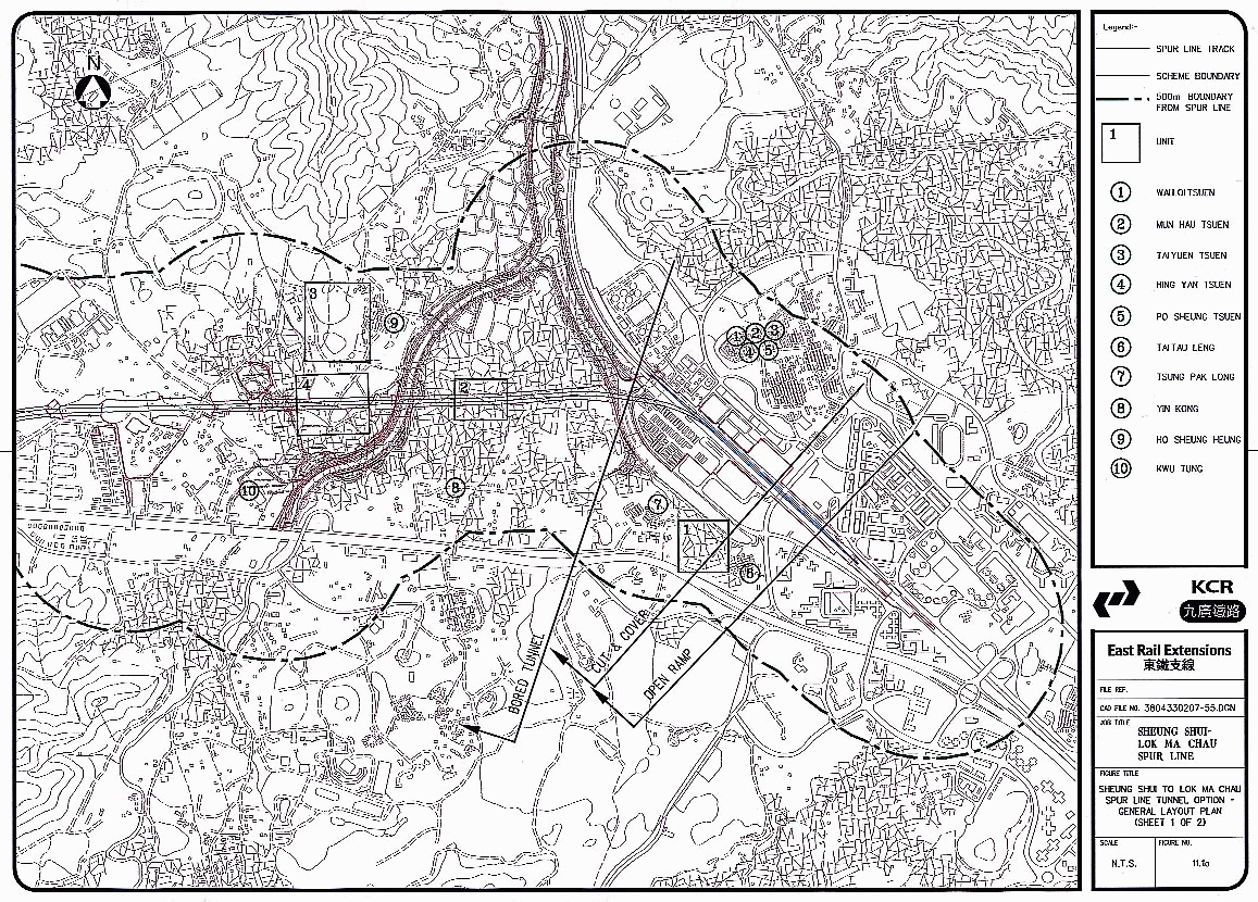
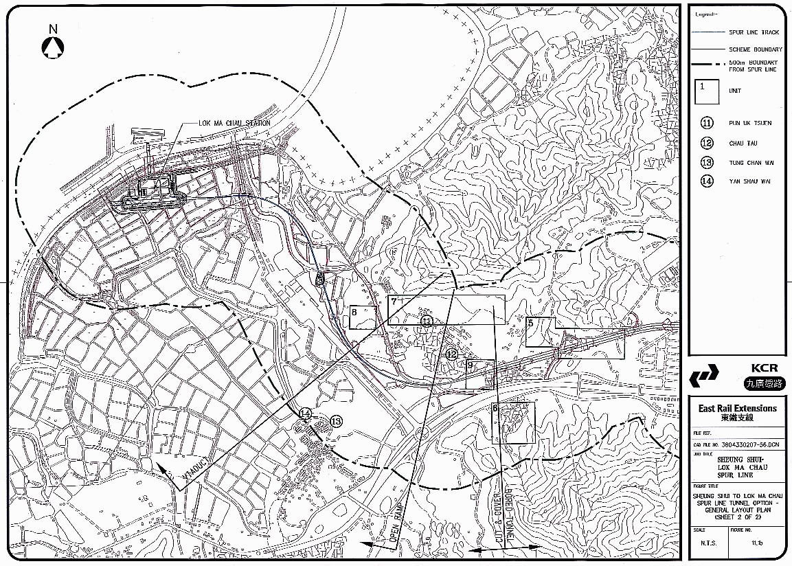
11.4.1 The Study Area lies between Sheung Shui and Lok Ma Chau, in the northern New Territories (Figure 11.1a and 11.1b). It extends westward from Sheung Shui station, beneath Long Valley and Kwu Tung to Chau Tau; westward on viaduct abutment turning northward at San Tin to Lok Ma Chau. For the purposes of the CHIA the Study Area is defined as extending 500 m to either side of the proposed alignment. The Study Area for the alignment incorporating a tunnel section remains unchanged from the previous EIA. (Binnie 2000)
Existing Impacts in the Study Area
11.4.2 There are a variety of existing land uses within the Study Area:
• Large areas devoted to fishponds west of Lok Ma Chau and north of San Tin;
• Relatively undeveloped traditional villages;
• Traditional villages in the process of ongoing development;
• Agricultural fields, abandoned and in use;
• Market and domestic gardens;
• Highly developed urban centres in the area of Sheung Shui;
• Streams, rivers and drainage channels;
• Major road access, i.e. Castle Peak Road, Fanling Highway, San Sham Road;
• Small village access roads;
• Abandoned grenade range near Chau Tau;
• Former military quarters at Dill's Corner;
• Light industrial buildings, abandoned and in use in the vicinity of Tung Fong and Fung Kong;
• Pig Farms, near Chau Tau and Pak Shek Au;
• Sewage Treatment Works at Shek Wu Hui;
• Lo Wu Camp.
Impacts Associated with the Proposed Works
11.4.3 The following potential impacts may result from the construction and operation of the proposed works in the Study Area:
• physical impacts on historical buildings and structures, including changes in water table, vibration damage and structural settling;
• aesthetic impacts on historical buildings and structures;
• cutting and displacement of archaeological deposits during the construction phase.
11.4.4 Specific impacts, which may arise from works at various points along the proposed alignment, are described in further detail in this Chapter.
Geological and Topographical Background
11.4.5 The topography of the area consists of the valley of the Sheung Yue Ho (Beas River) in the east, broken in the north by the southern slopes of Tai Shek Mo. The flat valley conditions continue westward to Pak Shek Au where the slopes converge from the north and south to form a narrow pass. Valley conditions resume to the west at Chau Tau. The Study Area curves to the north here and is occupied primarily by ponds to the west of Lok Ma Chau Road.
11.4.6 The valley of the Sheung Yue Ho is filled with Pleistocene fluvial terraces and Holocene alluvial deposits reaching several tens of metres in places. A network of older, deep valleys, which dissected the Pleistocene topography of the territory down to a lower elevation than the present sea level, filled in to create the present outlook (Geotechnical Control Office, 1988 a: 17). The valley drains northward into the Lo Wu catchment basin and into the Sham Chun River.
11.4.7 The basic geology along the north of the Study Area comprises Lok Ma Chau Formation: metamorphosed sedimentary and volcanic rocks lying in a north-east trending belt of low relief from Tuen Mun. These colluvium deposits mantle the foot slopes of most of the north-east trending hills. These deposits are widely distributed and entirely derived from the Lok Ma Chau Formation (Geological Map of Hong Kong, Kowloon and the New Territories). The rocks of this formation generally weather to produce moderately deep (1-2m), uniform or gradational red to red-brown clayey metasediments (Geotechnical Control Office 1988a: 30).
11.4.8 The rock formation of the south of Pak Shek Au is volcanic of the Repulse Bay Formation; sedimentary rocks, acid lavas, coarse tuff, agglomerate, dominantly pyroclastic rocks with some lavas. This formation produces a thin (<1m) soil horizon, followed downwards, especially on lower slopes by yellowish brown sandy, completely weathered material overlying less weathered locally strongly jointed rock below an average depth of 11m (Geotechnical Control Office 1988b: 28).
11.4.9 At the end of the last ice age, about 15,000 years ago, sea level was approx. 120m. lower than present. The present area of Mai Po and San Tin was far inland and the underlying Lok Ma Chau formation rock was exposed, cut into a series of valleys which ran into the major river course along the line of present day Deep Bay. After the ice age, the sea level rose, reaching present levels about 6000 years ago. Deep Bay flooded to the line of Castle Peak Rd. with low rounded hills appearing as isolated islands in estuarine waters (dating of the lower part of marine mud in Chau Tau to 5093 +/- 130 to 5475 +/- 155 yr. BP). (Geotechnical Control Office, 1989: 116). This shallow sea slowly filled in as a result of sedimentation augmented by drainage and reclamation of the mangrove swamps to provide land for habitation and agricultural use, in particular for fish ponds. The use of the term Chau in local place names recalls the existence of such an environment in the recent past.
11.4.9
Modern Economic
and Developmental Setting
11.4.10 The Study Area covers a diversity of landscapes and settings as can be seen in the list of existing developments in this Chapter. Sheung Shui is a highly developed modern urban centre and the villages in the immediate area have all seen rapid development. The villages to the northwest are less urban and developed, to varying degrees. The area from Tsung Pak Long to Chau Tau consists mainly of modern structures used for residential, light industrial, manufacturing and agricultural purposes e.g. soy sauce manufacturing, metal recycling and pig rearing. There are also a number of relatively traditional villages which are undergoing development at varying rates, which, in some cases, unfortunately includes the destruction of historic buildings, e.g. Chau Tau. Many of the villages also contain a number of abandoned agricultural buildings especially those associated with small-scale pig rearing. The agriculture practiced by the villagers at present consists of small-scale gardens containing vegetable crops and fruit trees. There are larger market gardens around the village of Yin Kong.
11.5
Archaeological Field Evaluation and Impact Assessment
11.5.1 In this section the background, methodology and findings of the archaeological component of the CHIA are presented. These are followed by an assessment of the impacts that will result from the proposed project on any archaeological resources in the Study Area and recommendations for mitigation of these impacts.
Potential for
Prehistoric Archaeology in the Study Area
11.5.2 Sparse prehistoric finds dating back to the Bronze to early Iron Age have been found during the NENT Study EIA in the Fung Kong area and Ho Sheung Heung terraces (Maunsell 2001).
11.5.3 As discussed in Section 11.3, areas that are presently occupied by fishponds and river flood plains, were in prehistoric times shallow seas fringed by marshland and mangrove (Irving and Morton 1988). Within this environment present hillocks formed islands and islets; therefore the lower hill slopes and former shorelines of these islands may have the potential for prehistoric deposits. These include hillocks south-east of Ha Wan Tsuen; west of Lok Ma Chau Rd.; west of Pun Uk Tsuen; at Pak Shek Au; and just to the north-west of Pak Shek Au.
11.5.4
As a result of these findings,
unaltered lower hill slopes within the Study Area were viewed as areas of
archaeological interest when designing the field evaluation for the original
alignment. No prehistoric remains were recovered during the study period of
this EIA.
Potential for
Historical Archaeology in the Study Area
11.5.5 The alluvial plains within the Study Area have been formed within the last millennium (Irving and Morton 1988) and have been occupied and farmed since at least the 12th c. by Chinese immigrants. The Study Area was settled by immigrants from the beginning of the Song Dynasty (960-1279 AD) down to the Ming Dynasty. Historical studies of the lineage of the local residents reveal that there were 4 major clans among these early settlers in the Sheung Shui to San Tin area (Lim 1997, Bard 1988, Hayes 1983):
1. The Hau clan who arrived in the 12th c.; their original village of Ho Sheung Heung remains the clan centre;
2. The Pang who arrived in the late Sung (1120-1280 AD) at Fanling, and spread beyond;
3. The Liu family who settled in Sheung Shui during the Yuan dynasty in the 14th c.;
4. The Man who were last to arrive, between the mid 14th and the beginning of the 15th c. when the shortage of good land forced them to settle in San Tin, at that time on the edge of poorly drained marshland. They settled on the edge of mangrove swamps and established the village of San Tin (which translates to New Fields) in 1279 (Irving and Morton 1988).
11.5.6 During the reign of Qianlong (1736-1796 AD) the Pun, the other main clan residing in the Study Area, settled in Pun Uk Tsuen.
11.5.7 The potential therefore exists for archaeological deposits from the historical periods of clan immigration, particularly from the Sung (960-1279 AD), Yuan (1271-1368 AD), Ming (1368-1644 AD) and Qing Dynasties (1644-1911 AD). Earlier material from the Tang dynasty (618-907 AD) was recorded on alluvial terraces at Kai Leng to the south of Sheung Shui and at a number of sites in the northern end of the Tuen Mun Valley (AMO pers. comm.).
11.5.8 The cultivation of rice was the main activity of the indigenous people in the Study Area (Ho Wei Yue 1962). The influx of migrants in the 1960's brought the cultivation of vegetables, which later took over from rice as it was more profitable. An example of this process can be seen in the village of Yin Kong, where the alluvial plain to the north of the village still supports small-scale commercial agricultural plots that once were paddy fields (local informant).
11.5.9 In the 1930's fish pond farming expanded from mainly the Yuen Long area across Deep Bay to the Lok Ma Chau area, for a while taking over the importance of paddy fields in the west of the Study Area. (Fung Chi Ming 1995, Irving and Morton 1988)
11.5.10 The present land use of the area of large commercial pig farms e.g. those located to the east of Chau Tau, evolved about 40 years ago (local informants). Previously, pigs were kept within and on the outskirts of villages such as Chau Tau where their former enclosures can be seen.
11.5.11 Along with agricultural activities, light industrial endeavors are also characteristic of the Study Area. For example, in the vicinity of Kwu Tung, there are several soy sauce factories, which have been established there for many years. These factories, while housed in modern structures around 30 years in age, still maintain traditional manufacturing methods (Baker 1980, local informant). Other examples of traditional industries include a rattan factory, grass mat making and joss stick manufacture.
11.5.12 Archaeological material could include the remains of villages and farms, historical field systems and agricultural features, early fishpond bunds and structures associated with early light industry.
11.5.13
A test pit excavated south of Ho
Sheung Heung as part of the CHIA for the previous EIA for the viaduct rail
alignment revealed a fragment of a 12th c. Song dynasty bowl (P. Lam
pers. comm.). Unfortunately, the associated material was fragmentary and
undiagnostic and it is not possible to say whether the finds represent a Song
deposit or an out of situ find. Further field evaluation was carried out to the
west of Ho Sheung Heung as part of the CHIA for the Planning and Development
Study on North East New Territories. Testing revealed historical deposits (late
Tang, Song, Ming and Qing Dynasties) in the area of Fung Kong and Ho Sheung
Heung (Maunsell 2001).
Selection of
Evaluation Units
11.5.14 In order to evaluate the archaeological potential of a study area of this size it was necessary to implement a sampling strategy. Areas were identified which were accessible to testing methods. i.e. not covered by concrete or structures or heavily modified due to landscaping or digging of ponds. From these areas evaluation units were selected in an attempt to sample all the landforms found within the Study Area. Two units selected at the preliminary desk-based stage were later eliminated from the evaluation. They were found upon further investigation to be completely altered, and substitute units were selected. The cancelled units were:
Unit 4 an alluvial area within the alignment to the north-east of Dill’s Corner which was found to be covered by a lorry park, container storage and car repair workshops;
Unit 9 an alluvial area between Lok Ma Chau Road and San Sham Road which has been artificially filled and leveled to create car and lorry parking.
The new Units 4 and 9 are substitutes for these cancelled units.
Evaluation Units
11.5.15 The following Units were evaluated (Figures 11.1a & b):
Unit 1 West
of Tai Tau Leng
Between Tai Tau Leng and Tsung Pak Long to the west; just north of Castle Peak Road [ca. 0.25 km2]. This is an area of alluvial terraces occupied by in use and abandoned fields. The area is relatively low-lying between 3.8 and 4.1 mPD.
Unit 2 North
of Yin Kong
On the alignment in the middle of the river
flood plain; north of Yin Kong [ca. 0.25 km long]. This is an area
positioned in the centre of the alluvial terraces. The area is low-lying
between 3.0 and 5.3 mPD and comprises agricultural land dissected by irrigation
and drainage channels and ponds.
Unit 3 Ho
Sheung Heung
The unit samples the lower hill slopes to the west of Ho Sheung Heung [ca. 0.5km N-S x 0.25 km E-W]. The village of Ho Sheung Heung is situated to the east of the hillock, but the unit includes relatively undisturbed wooded areas at elevations up to 27 mPD.
Unit 4 South
of Ho Sheung Heung
This unit is situated in the valley area within the proposed alignment [0.5 km N-S x 0.25 km E-W]. It lies at 5.2 to 7.9 mPD at the base of the hills of Ho Sheung Heung (Unit 3) and is occupied by abandoned fields, several structures and light industry.
Unit 5 Pak
Shek Au
North of Pak Shek Au. [about 0.75 km long]; the
unit is positioned to test the lower hill slopes with elevations from 12 to 24
mPD. The areas at the transition between the hill slopes and the valley floor
are covered with small-scale pig farms, minor industries and container storage.
Part of the lower foot hills have been impacted by the construction of roads
and graves.
Unit 6 South
of Castle Peak Road
South of the highway [slightly larger than 0.25
km2]; situated to sample the lower hill slopes in this area of
volcanic rock and the rear of the valley at elevations from 14 – 24mPD. The
area is filled with nurseries and houses, while portions of the lower foot
hills are occupied by graves.
Unit 7 Pun
Uk Tsuen
This unit is situated behind the village of Pun Uk Tsuen and comprises the wooded lower slopes of the small hill to the south-west and the valley bottom adjacent [about 0.5 km long]. The unit lies from approx. 7 to 27 mPD.
Unit 8 Hill
to west of Lok Ma Chau Rd.
This unit comprises the northern slopes and
bottom of the hillock [ca. 0.25 km long] of colluvium and Lok Ma Chau
formation. This hillock would have formed an island in former times; at present
a large concrete road has been constructed and it contains many graves.
Elevations examined extend from 9 to 20 mPD.
Unit 9 East
of Chau Tau
This unit lies in the valley bottom in a low
and marshy area (3.4 – 5.7 mPD) of fields, ponds and structures. It
measures approx. 0.2 km long and 0.1 km wide.
Field Evaluation Methodology
11.5.16 In each of the Evaluation Units the same field methodology was applied, in accordance with AMO requirements. This involved the following:
• Surface scanning for archaeological evidence was carried out, wherever possible;
• Systematic auger testing was carried out in each unit, with the number and spacing of tests depending on the size of the area and the degree of disturbance; and
11.5.17 A total of 5 test pits were excavated; one in both units 3 and 7 based on data gathered during the desk-based stage. Three additional test pits were excavated in locations selected on the basis of the auger testing results. The test pits were positioned to maximise stratigraphical information.
11.6
Summary of Findings of Archaeological Field Evaluation
Summary of the
Surface Field Scan
11.6.1 Most of the surface of the Study Area was covered in dense vegetation and/or structures. However, a field scan was carried out, wherever possible with particular attention to agricultural fields and cuts, such as abandoned graves, streambeds and natural cuts on hill slopes. No archaeological material was recovered during these field scans.
Summary of the
Auger Testing Programme
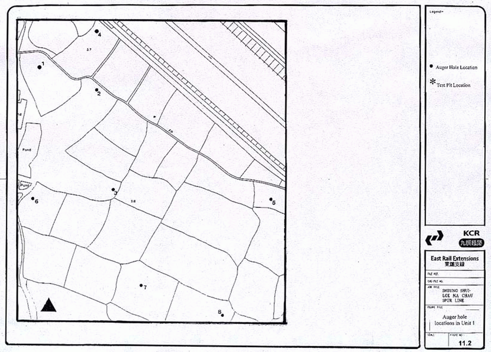
Unit 1
West of Tai Tau Leng (Figure
11.2)
11.6.2 Eight auger holes were executed on this valley floor area near the Shek Sheung River. The data indicates wet agricultural activities for the upper strata, while alluvium forms the lower sequence. No archaeological artefacts or deposits were located.
Unit 2
Area north of Yin Kong (Figure
11.3)
11.6.3 Eight auger holes were carried out in this valley floor area. The upper strata of the soils show agricultural activities, while the lower indicate alluvium to weathered alluvium. No archaeological artefacts were recovered by these auger tests.
Unit 3
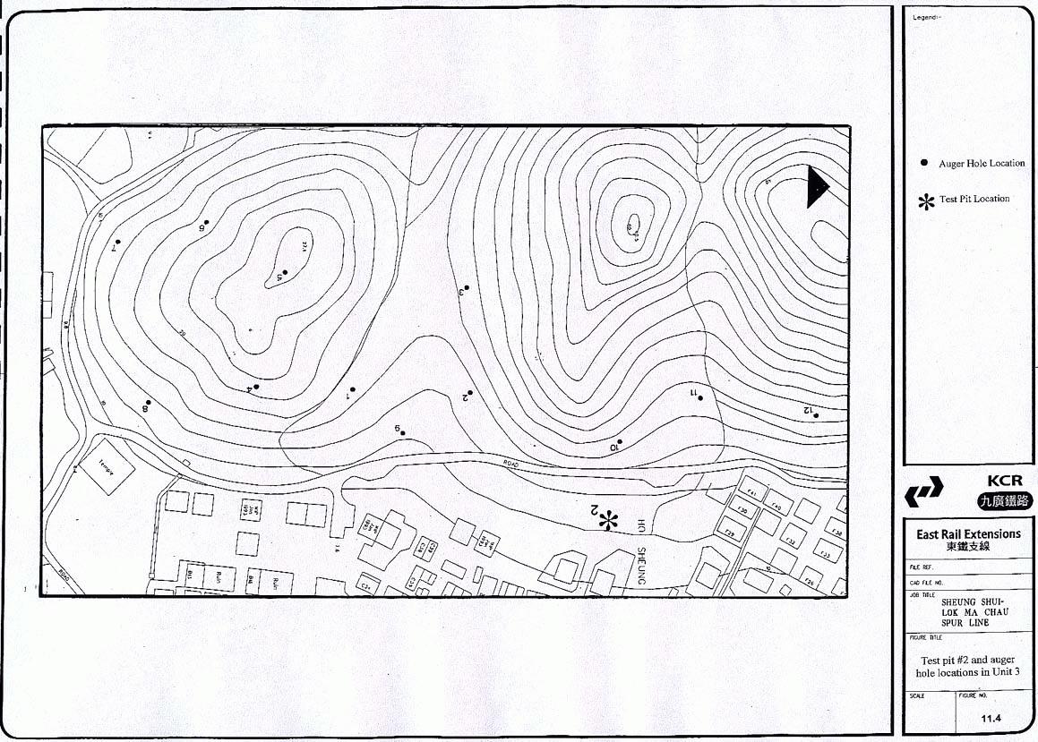
Ho Sheung Heung (Figure
11.4)
11.6.4 Twelve auger holes were executed on the low-lying hill and lower hill slopes of Ho Sheung Heung. The auger hole data indicates in situ deeply weathered bedrock on top of the hill and weathered bedrock and sterile colluvium on the hill slopes. No archaeological deposits were established.
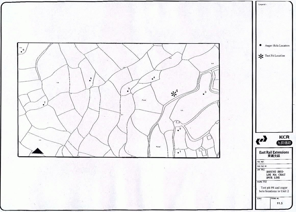
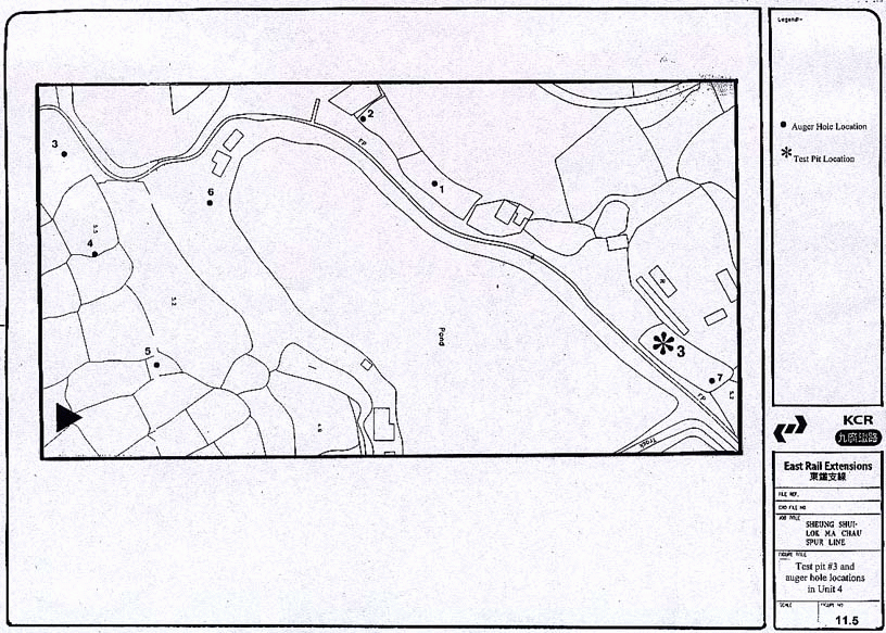
Unit 4 Area to the south
of Ho Sheung Heung, in the alignment (Figure
11.5)
11.6.5
Seven
auger holes were conducted in the flat alluvial area to the south of Ho Sheung
Heung. Sterile alluvium can be established in each auger hole, some
covered by fill. No archaeological material was found by these auger tests.
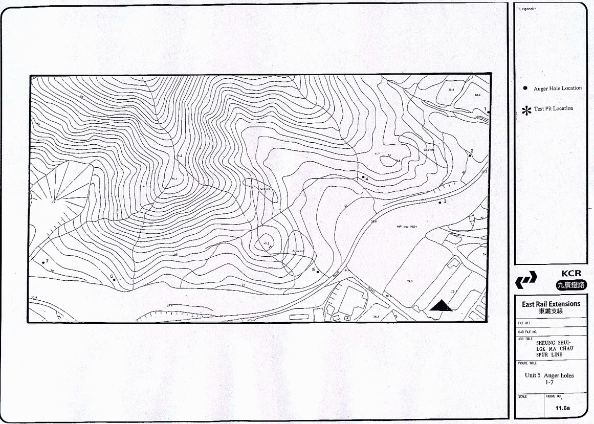
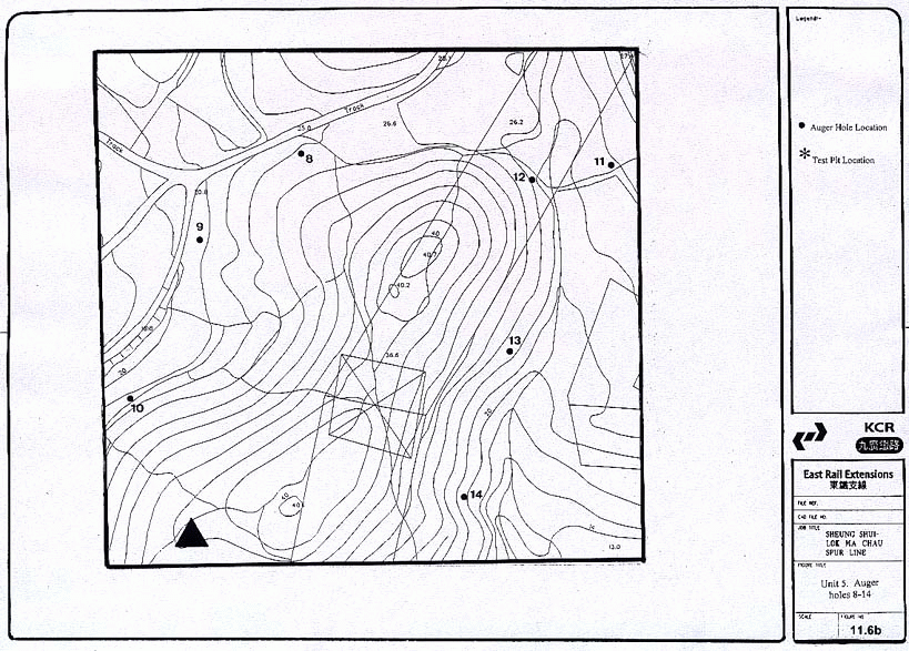
Unit 5
Pak Shek Au (Figures 11.6a
& b)
11.6.6 Fourteen auger holes were executed on the lower hill slopes at Pak Shek Au. The auger hole test results indicate a very thin cover (<1 m) of sterile soil on top of weathered bedrock. No soil strata suggested archaeological potential.
Unit 6
South of Castle Peak Road (Figure
11.7)
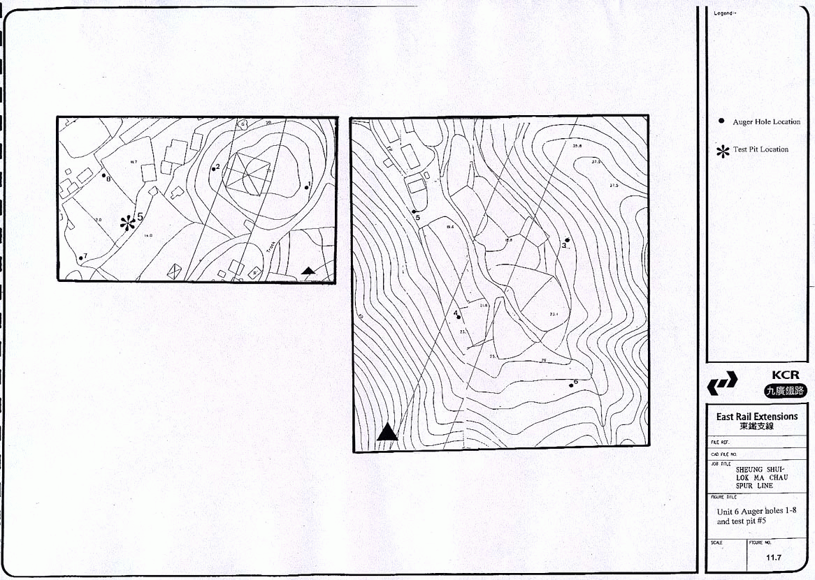
11.6.7 A total of 8 auger holes were carried out. Two auger tests were conducted on the hillock to the east of the valley, which is largely occupied by a nursery and a large concrete platform. Four tests were executed on the lower hill slopes at the rear of the valley. This area supported a thin soil cover over rocky colluvium or bedrock. Finally two auger holes were positioned on a raised terrace to the east of the river; these auger holes too were unsuccessful due to rocks. No archaeological material was recovered.
Unit 7
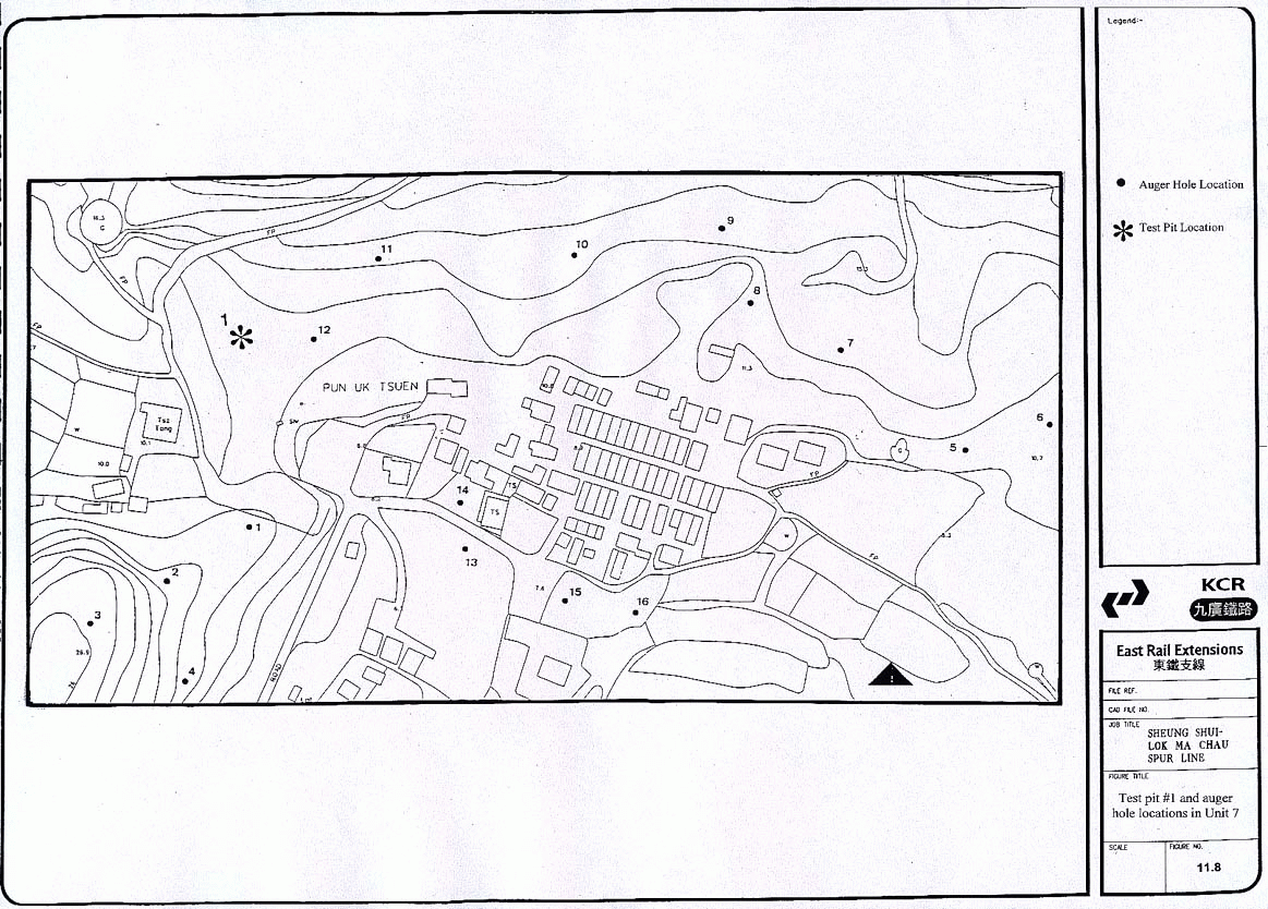
Pun Uk Tsuen (Figure 11.8)
11.6.8 A total of 16 auger holes were conducted in Pun Uk Tsuen. The hillock on the western end of Pun Uk Tsuen has a thin soil cover on deeply weathered bedrock, whilst the lower hill slopes behind the village were less uniform. Some areas although densely vegetated were covered in rubbish and/ or modified. Other areas had a thin subsoil cover over weathered bedrock or colluvium. Tests carried out in the alluvial area in front of the village, indicate sterile alluvium. Modern village ware sherds were recovered from auger holes 6, 10 and 12.
Unit 8
Hill west of Pun Uk Tsuen (Figure
11.9)
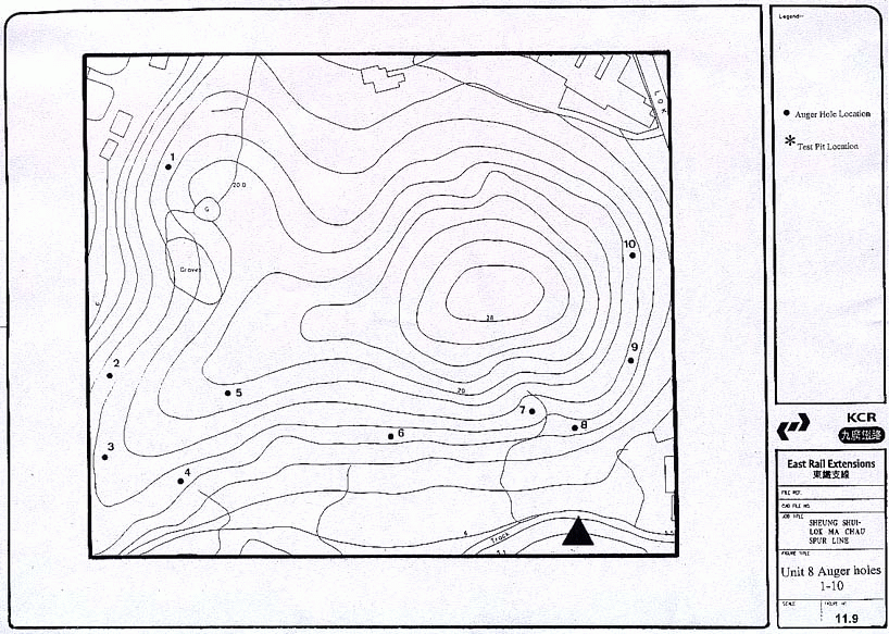
11.6.9
10
Auger holes were carried out on the hillock. The strata of the hillock proved
to be a shallow soil cover on bedrock, in some places decomposing. This could
be verified in the sections of the open pits of relocated graves. No
archaeological deposits were located in this unit.
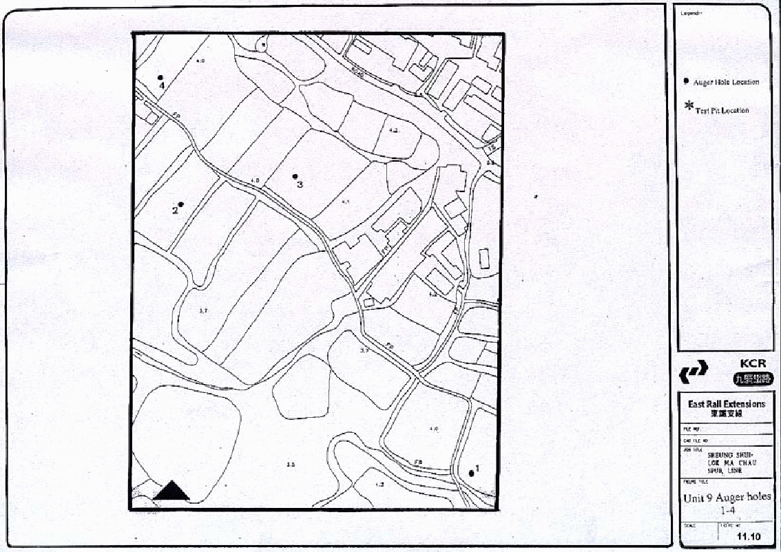
Unit 9
Area East of Chau Tau (Figure
11.10)
11.6.10
A total of 4 auger holes were conducted in this
area. The area is waterlogged and water table was reached at approximately 80
cm. The strata indicate a wet alluvial sequence.
Summary of the
Test Pit Results
11.6.11 Five test pits were excavated, measuring 1.5 x 1.5 m, except at Pun Uk Tsuen where topography allowed for a 1.5 x 2 m and south of Castle Peak Road (1 x 1 m) where the size was decided by the land owner. Test pits 1 and 2 were carried out on the basis of the data collected through desk-based research. Test pits 3, 4 and 5 were positioned on the basis of information gained from the auger survey and with a view to assessing the valley plains as well as lower hill slopes. A summary of the findings is given below. The full details of the test pits are recorded in Appendix A11.1.
Test Pit 1
11.6.12 Test pit 1 was located on the lower hill slope behind the village of Pun Uk Tsuen, near auger hole 12, which revealed a modern village ware sherd at 48cm. It was excavated to a depth of 74 cm and contained top- and sub- soils over decomposing rock. The first three contexts to a depth of approximately 20cm revealed tile fragments, roots and modern village ware. Contexts below were sterile.
Test Pit 2
11.6.13
Test
pit 2 was located on the lower hill slope behind the village of Ho Sheung
Heung. It was excavated to a depth of approximately 70cm. A thin topsoil seals
a fill layer, which lies on colluvium and finally weathered bedrock or
concreted colluvium. No finds were recorded in contexts 3 and 4.
Test Pit 3
11.6.14
Test
pit 3 was situated on the alluvial plain approximately 80m to the south of Ho
Sheung Heung hill. The test pit was excavated to a depth of 105cm and an auger
hole was carried out to verify lower-lying strata. The upper contexts
represented fill, followed by alluvium and weathered alluvium, until the
testing was stopped by rock. Throughout contexts 1 to 5 village ware and tile
fragments were recovered; at the depth of 66cm (context 6) below surface a
fragment of a Song bowl was found. This vessel dates to the 12th c.;
unfortunately the associated material was too fragmentary and undiagnostic to
say whether the finds represent a Sung deposit or an out of situ find (Peter
Lam pers. comm.).
Test Pit 4
11.6.15 This test pit was located in the valley plain to the north of Yin Kong in a disused agricultural field. The test pit was excavated to a depth of approximately 95cm after which further testing was conducted with the auger. The upper two contexts to a depth of ca. 25cm represent recent wet agricultural activities, followed by a deep sequence of alluvial strata. No archaeological artefacts or deposits were found.
Test Pit 5
11.6.16
The
test pit was located on a Pleistocene river terrace. It was excavated to a
depth of approximately 70cm. The stratigraphy consisted of topsoil covering
subsoil and colluvium on top of weathered debris flow deposit (Hong Kong
Geological Map, 2). No archaeological features or material was recovered.
11.7
Conclusions of the Archaeological Field Evaluation
11.7.1 The archaeological field evaluation was designed to sample the limited portions of the Study Area which have not been altered by recent development. This evaluation in conjunction with desk-based study revealed the following (Table 11.1):
• There is no in situ or displaced evidence of prehistoric occupation within the Study Area as a whole or specifically within the areas to be directly impacted by the proposed alignment.
• The lower hill slopes to the north and south have been heavily modified and eroded and reveal no evidence of historical archaeology or soil deposits with potential to contain such deposits. Evaluation has shown this to be the case north of Pak Shek Au, the only hill slope section which will be directly impacted by construction.
• Valley bottom areas in the north-west and east of the Study Area are wet, marshy or used as ponds. Evaluation of available dry areas revealed deep sterile alluvial deposits only. However, potential exists for historical archaeological material as exhibited by the finding of a Song sherd in Unit 4. This potential is highest in areas adjacent to traditional historical villages such as Ho Sheung Heung.
Table 11.1
Summary of the archaeological findings in each
evaluation unit
|
|
Unit 1 |
Unit 2 |
Unit 3 |
Unit 4 |
Unit 5 |
Unit 6 |
Unit 7 |
Unit 8 |
Unit 9 |
|
No cultural material of any period |
4 |
4 |
4 |
- |
- |
4 |
- |
4 |
4 |
|
Modern material and debris found |
- |
- |
- |
4 |
4 |
- |
4 |
- |
- |
|
Material of archaeological interest found |
- |
- |
- |
4 |
- |
- |
- |
- |
- |
11.8
Assessment of Impacts arising from the Spurline Construction
11.8.1 The following assessment reviews the nature and extent of impacts on known and potential archaeological deposits, which may arise from the Spurline construction, for the vialink and tunnel section of the alignment.
Area West of
Chau Tau
11.8.2 The proposed alignment west of Chau Tau remains unchanged from that assessed for the original viaduct option as assessed in the previous EIA (Binnie 2000). The archaeological field evaluation for the alignment has designed to sample the limited portions of the Study Area which have not been altered by recent development (Units 7 and 8). The evaluation in conjunction with desk-based study revealed no in situ or displaced evidence of prehistoric or historic occupation within this part of the Study Area, specifically within the areas to be directly impacted by this portion of the alignment.
11.8.3 The lower hill slopes to the north and south have been heavily modified and eroded and reveal no evidence of historical archaeology or soil deposits with potential to contain such deposits.
Chau Tau: West
Approach
11.8.4 The proposed alignment will approach Chau Tau from the west above ground. A length of open cut through fill and cut and cover through approx. 5m of fill and alluvial gravel and sand into decomposing tuff (DT) will lead to the TBM recovery shaft.
11.8.5 Field evaluation showed that the valley bottom areas west of Chau Tau are wet, marshy or used as ponds (Unit 9). Evaluation of available dry areas revealed deep, sterile alluvial deposits only. As a result, the potential for tunnel works to impact on archaeological deposits is low.
11.8.6 The site of the shaft will be excavated through fill, an area of alluvial gravel and sand into DT. Works associated with the shaft will include a railway emergency repair material storage yard and other above ground facilities, Ventilation Building, drainage channels, portal and access roads.
11.8.7 Auger testing was carried out in this area during the assessment of the viaduct option (Binnie 2000). It revealed waterlogged conditions indicating a wet agricultural sequence with low archaeological potential.
Between Chau Tau
and Sheung Shui
11.8.8 A rail tunnel is proposed under Long Valley, from Sheung Shui to Chau Tau; this will be a bored twin tunnel for 3.5km in completely decomposing granite (CDG) at a depth of about 15m below ground level. It is not expected that boring at such depth could impact on any known or unknown archaeological deposits. Sediment settlement in the order of 25mm can be expected.
11.8.9 However, two EAP ventilation shafts and a station box will be excavated between Sheung Shui and Chau Tau.
(1) EAP shaft [West]
The western shaft is located north of Pak Shek Au, in an area of concrete and structures not previously tested. Excavations for the shaft will be through a thin layer of fill, approx. 1m of alluvium into DT.
Auger testing in Unit 5, immediately to the north of Pak Shek Au revealed a very thin cover of sterile soil on top of weathered bedrock. No soil strata suggested archaeological potential.
(2) EAP shaft [East]
The eastern shaft is located south of Ho Sheung Heung, on the western bank of the channeled river. Excavations will go through fill, alluvium and then DT.
This site lies between Units 2 and 4. A series of 8 auger holes were carried out in Unit 2, located on the valley floor; sterile fill over sterile alluvium was recorded and no archaeological material or soils.
However, a test pit was excavated in Unit 4 approx. 100m northwest of the EAP shaft which, confirmed the archaeological potential of this area (Test Pit 3). Upper contexts comprised fill, followed by alluvium and weathered alluvium over rock. At a depth of 66 cm. below the surface a fragment of a Song bowl was found. This vessel dates to the 12th c.; unfortunately associated material comprising village ware sherds and tile was too fragmentary and undiagnostic to say whether the finds represented an in or out of situ deposit.
Further field work was carried out as part of the EIA for the Planning and Development Study on NENT in the area of the Sin Wai Nunnery, immediately to the north of the test pit (Maunsell 2001). Surface survey revealed Qing, Song and late Tang sherds, further highlighting the archaeological potential of the area. Seven auger holes and four test pits were carried out to the north of those undertaken for the Spur Line EIA. HSH-TP1 revealed a layer with late Ming to Qing pottery and another with Bronze Age and late Tang to Northern Song material.
(3) Kwu Tung Station Box
Large scale excavations will be carried out for a station box at Kwu Tung, northeast of Dill’s Corner. The area is currently covered by concrete and occupied by structures. The box will measure 300m long and approx. 20-25m deep. Excavations will be through fill, up to 15m alluvium into DT. An additional EAP will form part of the box complex.
Archaeological field evaluation was carried out for the NENT Study (Maunsell 2001). Surface survey and approximately 19 auger holes were carried out within the footprint of the proposed station box; no test pit was excavated in the area. Three Song celadon sherds were found on the surface, 2 of which were recorded within the footprint, near the northern limit of former Dill’s Corner. Six auger holes (AH 76-79, 81 and 106) were located in the area to investigate further, but no additional cultural evidence was found.
The generalized stratigraphy for the area is described as:
Layer 1 topsoil, sandy, dark brown
Layer 2 subsoil, loamy, brown to yellow
Layer 3 alluvial sediment, mud, dark grey to black
Layer 4 fluvial settlement, silt, yellow or white, medium to coarse sand with gravel
Sheung Shui
11.8.10 Works at Sheung Shui Station will include a section of cut and cover tunnel, and a TBM launching shaft close to the existing East Rail at Sheung Shui Station. All excavations will impact areas where archaeological potential is low or nil due to previous ground works, site formation and construction.
Table 11.2
Summary of potential impacts on identified resources
within the alignment
|
Alignment location |
Nature of Works |
Archaeological Findings |
Potential Impacts |
|
Lok Ma Chau to Chau Tau |
viaduct |
None |
None |
|
Chau Tau |
cut and cover tunnel |
None |
None |
|
Chau Tau |
TBM extraction and associated works |
None |
None |
|
West EAP |
Shaft excavation |
None |
None |
|
East EAP |
Shaft excavation |
Archaeological material south of Ho Sheung Heung |
4 |
|
Kwu Tung Station Box |
Major excavation |
3 sherds found during surface survey |
4 |
|
Sheung Shui |
TBM launching shaft |
None |
None |
11.9
Mitigation Recommendations
11.9.1 Despite the presence of several Song celadon sherds on the surface, the results of this study found no sub-surface evidence for archaeological deposits in the vicinity of the Kwu Tung station box. Auger testing revealed no artefacts and no cultural soils; the stratigraphy shows that this low area was a flood plain until recent times and has low archaeological potential. However, because of the presence of historical material it is recommended that further testing be carried out within the footprint of Kwu Tung Station Box and its associated works before any works commence. The exact number and location of test pits within the footprint must be agreed with the AMO and a license to undertake archaeological work obtained by the cultural heritage consultants.
11.9.2 Testing to the west of the EAP Shaft [East] has revealed that this is an area of high archaeological potential. For this reason it is recommended that focussed testing be carried out within the footprint of the shaft and its associated structures before works commence. The exact number and location of test pits within the footprint must be agreed with the AMO and a license to undertake archaeological work obtained by the cultural heritage consultant.
11.10
Historical Buildings and Structures Survey and Assessment
11.10.1 In this section the background, methodology and findings of the historical buildings and structures component of the CHIA will be presented. They will be followed by an assessment of any impacts that will result from the proposed development on cultural heritage resources in the Study Area. Finally, recommendations for mitigation of these impacts will be presented.
Historical
Potential within the Study Area
11.10.2 This area has been occupied and farmed since the 12th century. Whilst structures dating from this early period are no longer present, there are within many of the villages a number of historical buildings, such as temples and ancestral halls with well documented and extended histories. From a preliminary viewing of the villages, it was obvious that many contained numerous historical buildings. The Antiquities and Monuments Office has listed a number of known historical buildings, both within the Study Area and in its vicinity, see Appendix A11.1. These include ancestral halls, temples, police stations, a mansion, a nunnery and a walled village, i.e. Hakka Wai.
Village
Background
11.10.3 A total of 296 structures was recorded during the survey of which 282 were undocumented structures and 14 were Antiquities and Monuments Office highlighted structures. The villages were all easily accessible and this allowed for relatively straightforward identification of the historical/ cultural resources. The Survey was undertaken to augment previous reports and to systematically record any additional heritage resources within the Study Area in greater detail. The completed recording forms are presented in Appendix A11.1. It should be noted that the sequence of the structures in the catalogue is geographical rather than numerical. Synopses of the buildings are presented later in this Chapter. The locations of the structures are shown on 1:1000 scale maps, Figures A11.1 to A11.17.
11.10.4 The occupation patterns, types and condition of the historical resources varied throughout the Study Area. A brief description of these details for each village is presented below to highlight the different settings and backgrounds of the historical resources.
11.10.5 Pun Uk Tsuen: The majority of the historical buildings were residential structures, either abandoned or being used for storage. The renovations were minimal in many cases. Several structures retained original decorative features, i.e. canopies and friezes, ranging from poor to moderate condition. There was no ancestral hall or temple. Three shrines were recorded. To the west of the village there were the ruins of a nunnery, abandoned approximately thirty years ago. There were numerous scatterings of cut stone, removed from renovated or demolished buildings, in the village.
11.10.6 Chau Tau: This village contained a number of abandoned residential structures. A large number of the buildings contained original decorative features, i.e. canopies and friezes in moderate condition. A small number of the historical structures was occupied and renovated. There was also a small number of agricultural structures, mainly to do with pig rearing, the practice of which was moved out of the villages and to the surrounding countryside approximately thirty years ago. The Tse Tong was a modern reconstruction.
11.10.7 Yin Kong: The majority of the historical structures in this village were inhabited domestic structures. They had often undergone modernisations, such as façade additions with parapets, tiling on interior walls and the installation of air conditioners. A few structures did retain original decorative features, such as canopies, friezes and mouldings, though they were almost all in poor condition. There was no temple or Tse Tong in the village. There was a large shrine to the north of the village and an inscribed stone with a Buddhist blessing at the corner of the road leading to the village and Castle Peak road. There were a number of instances of reuse of architectural stone slabs, e.g. lintels, door frames and corner stones, for items such as benches and stands. Fragments of the original village wall were also identified and recorded.
11.10.8 Tai Tau Leng: Almost all of the historical buildings within this village had been demolished and replaced by modern structures. There was only one traditional village house remaining. Fragments of the original village wall, a renovated gatehouse and a well were also recorded. A small amount of stone slabs from demolished historical buildings were identified.
11.10.9 Tsung Pak Long: This village contained a number of occupied historical residences, ranging in degree of renovation. A number of decorative features, such as canopies, friezes and mouldings were retained on the structures, ranging from moderate to poor condition There was also a row of ancestral halls representing the five clans of the village, ranging from relatively unrenovated to completely modernised. There was a walled compound of buildings belonging to the Chan clan in the village, in an unrenovated state. There were also shrines and a well. There were examples of abandoned and reused cut stone slabs in the village, one being used as a shrine.
11.10.10 Kwu Tung: An area predominated by light industrial buildings and modern residential structures. The only recorded historical features were a house built in 1936, two grave/shrines associated with it and a cut stone lined channel, approximately thirty to forty years old, but traditional in style.
11.10.11 Ho Sheung Heung: This village contained a temple complex, nunnery and ancestral hall, all of which were moderately unrenovated. A number of the residential structures contained traditional canopies and friezes in moderate to poor condition. There were also a series of ruins and abandoned residential structures throughout the village.
11.10.12 Mun Hau Tsuen: This village contained a large ancestral hall, which has been renovated. The majority of historical structures were residential, occupied and renovated to varying degrees. There were several shrines in the village. A number of the residential buildings retained decorative features, such as canopies and friezes, which ranged from moderate to poor in condition.
11.10.13 Tai Yuen Tsuen: There were a small number of historical buildings in this village, mainly residential. Only one terrace row retained traditional decorative canopies and friezes. They were in moderate condition. The structures were for the most part occupied and renovated to various degrees. There was also an ancestral hall and abandoned study hall in the village.
11.10.14 Hing Yan Tsuen: The only historical buildings in this village were a pair of green brick structures that were being used as a storage area and a house. The gate was of modern construction and was situated on the site of a former study hall.
11.10.15 Po Sheung Tsuen: This village contained a number of historical residences, a somewhat equal number of abandoned and inhabited structures. There were also varying degrees of renovation to the structures. In unrenovated structures the decorative features, i.e. canopies, friezes and mouldings, of the buildings were generally in poor condition. There were also several wells and shrines in the village.
11.10.16 Wai Loi Tsuen: The south end of the village contained an elaborate gate structure with a red sandstone arch. The majority of historical buildings were residential and inhabited. They were relatively unrenovated and any remaining decorative features were in poor condition. There were instances of reuse of stone slabs from demolished or renovated historical building.
11.10.17 Tung Chan Wai: This is a village with a number of courtyard houses and terraces, ruins and a shrine. Portions of the original wall are extant, including a tower.
11.10.18 Yan Shau Wai: This is another walled village with sections of original walls remaining. The area within the walls was completely residential and most of the structures were houses. The village was partially abandoned and many of the structures were derelict or ruinous.
Historical Buildings and Structures Survey Methodology
11.10.19 The survey consisted of a field evaluation incorporating the collection of photographic, oral and written information, on the architecture and history of the structures, all of which was recorded on specially designed forms, which collectively have been used to create a catalogue of all historical resources in the Study Area. A complete set of the reading forms has been submitted to AMO during the period of conducting the previous EIA. A synopsis of each structure and its location on a 1:1000 scale map is included in this report. The field survey recording forms were designed to provide a complete documentation of all identifiable pre-1950 structures as well as any more recent structures of cultural significance. The documentation incorporates both the architectural features and the historical attributes of the structures, such as previous uses, structural modifications and past associations with local families or prominent personages. The forms were based on AMO and ICOMOS (International Charter for the Conservation and Restoration of Monuments and Sites) standards for the recording of historical structures with modifications to suit the styles and situations of historic structures encountered in Hong Kong. The recording forms include general information about the structure, such as location, building type, usage and ownership, all of which is presented on the first page of the form. An architectural description of the structure, both exterior and interior where possible, including all visible features as well as alterations to the original structure make up the bulk of the recording form. Cultural and historical details of the building are also noted, where applicable. Finally, evaluation recommendations for the individual building or structure are supplied and any additional remarks are provided.
11.10.20 In the field, the historical structures were identified through a systematic visual inspection and interviews with the local residents. The structures were then located on 1:1000 scale maps and their locations highlighted. Once identified and marked on the map, the physical features of the structure both external and internal (with the permission of the occupant) were recorded and photographs of relevant features taken. The occupants were then asked about the history of the structure as well as any other related historical or cultural information, including estimated age of the building, previous uses and local family associations. The information gathered from the survey and desk based research was used to prepare assessments of the recorded structures’ historical and cultural significance and formulate mitigation recommendations.
Survey Focal Areas
11.10.21 The size of the Study Area and the density of historical resources within it necessitated a stratified approach to the assessment of potential impacts. The resources have thus been classified as falling into three discrete categories for purposes of recording and assessment and for the preparation of mitigation recommendations:
• Resources that will be directly impacted by the engineering works and will be threatened with either total or partial destruction. Due to the critical nature of these impacts, a preliminary field assessment was carried out of any structures that would be directly affected by the proposed alignment, the results of which were presented in the Preliminary CHIA report. The results shared that no historic structures would be directly impacted by the proposed alignment.
• Resources that fall inside the Study Area but will experience only indirect impact, e.g. aesthetic. This category encompassed the majority of surveyed structures. The resources within this category were recorded in detail and catalogued. All structures were assessed as to impacts to both the individual buildings and to village groupings as a whole.
• Resources that fall outside the defined Study Area but which have been highlighted by the AMO as being of special concern. These structures have been recorded and photographed in the same manner as the historical resources within the Study Area. Any possible impacts were assessed and any necessary mitigation measures proposed.
11.11
AMO Documented Heritage Buildings
11.11.1 Known historical resources highlighted by the AMO as having particular heritage value and requiring assessment of potential impacts are described in detail in Appendix A11.1.
11.12
Synopses of the Catalogued Buildings and Structures
11.12.1 There were a number of houses in the Study Area that were of a similar courtyard terrace design. A description of this house style is provided below in order to provide details of this building type which is commonly encountered in the Study Area.
11.12.2 Traditional Terraced Courtyard House: These structures are rectangular in shape and in general constructed of solid green brick walls. In some villages variations in construction materials were observed, i.e. a combination of green brick and coarse mud fabric walls, large, cut stone foundations and lower courses with green brick above and large cut stone corner blocks. The roofs consist of two sections, the front in unaltered structures has two parts, from front and rear that do not meet and create an open courtyard. Many of the structures now contain a flat roof over the front section completely enclosing it. This area of the house was originally the kitchen. A very tall doorway, with a double panel wooden door leads from the kitchen to the main living area of the houses. Wooden lofts were set up in the upper rear portion of the main section, accessed by traditionally constructed wooden ladders, some of which can still be seen. The tile and concrete roofs over the main sections of the houses are pitched and in many cases still contain a decorative roof ridge. The main entranceway consists of traditional double paneled wooden doors, often replaced with modern metal ones, with stone thresholds and lintels. Many of the houses contained decorative canopies of painted and/or molded plaster above the main entrances. The designs were continued along the walls of the structures in friezes. The canopies/friezes were in each case uniquely styled, in a number of different patterns, sometimes including inscriptions and poems. Local informants explained that the decorative features were created by the builders of the structures. Some of these houses are over 100 years old. The style was continued in some of the villages through renovations, though with alterations to the original design, such as parapets and roofing over of the front courtyard. The majority of the canopies were in what will be described as moderate condition, i.e. design and pattern still visible, paint faded and mouldings at least fifty percent intact. A few examples could be seen to be in better than average condition with paint colours and molded patterns clearly visible and the remainder were in very poor condition with only faint markings and moulding fragments visible. Details of catalogued buildings and structures are included in Appendix A11.1.
11.13
Assessment of Potential Impacts on Historical Buildings and
Mitigation Recommendations
11.13.1 It was determined that no historical structures or villages would be directly impacted by the proposed alignment. A number of villages will be within visual distance of the alignment and associated structures and will thus be indirectly impacted, though none will be closer than approx. 200m. The factors upon which the impact assessment will be based are presented in Table 11.3. These factors are applicable to villages as a whole and the specific historical buildings identified within them:
Table 11.3
Distance, orientation, existing landscapes between
villages
and the proposed alignment
|
Village |
Approx. minimum distance
to alignment |
Orientation of village to
alignment |
Existing landscape between
village and alignment |
|
Pun Uk Tsuen |
400 m |
towards |
agricultural fields, link road |
|
Chau Tau |
200 m |
towards |
agricultural fields. link road |
|
Yin Kong |
350 m |
towards |
agricultural fields |
|
Tai Tau Leng |
250 m |
towards |
multi-story development |
|
Tsung Pak
Long |
350 m |
towards |
multi-story development |
|
Kwu Tung |
250 m |
away from |
developed; buffer zone |
|
Ho Sheung
Heung |
150 m |
towards |
agricultural fields |
|
Man Hau
Tsuen SS |
200 m |
towards |
developed; buffer zone |
|
Tai Yuen
Tsuen SS |
200 m |
towards |
developed; buffer zone |
|
Hing Yan
Tsuen SS |
200 m |
towards |
developed; buffer zone |
|
Po Sheung
Tsuen SS |
200 m |
towards |
developed; buffer zone |
|
Wai Lo Tsuen
SS |
250 m |
away from |
developed buffer zone |
|
Yan Shau Wai |
450 m |
mixed |
agricultural fields; San Sham Road |
|
Tung Chan
Wai |
450 m |
mixed |
agricultural fields; San Sham Road |
11.13.2 The following points should be noted.
• Settings of most of the villages in the Study Area have already been compromised by previous development in the form of major roads, village, commercial and industrial development. For example, villages such as Tai Tau Leng and Tsung Pak Long, although moderately close to the alignment, have already had their vista affected by the building of a large commercial complexes and associated roads between themselves and the proposed alignment.
• The group of villages making up Sheung Shui Wai are a specific case. They have been enclosed in a buffer zone consisting of green belt, public buildings, access roads and noise barriers as mitigation of impacts associated with previous development. This will serve to protect them from any additional indirect impacts arising from the proposed rail project.
• The villages of Yan Shau Wai and Tung Chan Wai at the northern end of San Tin are almost half a kilometer from the alignment and are not oriented in its direction. An area of altered environment, including San Sham Road, lies between the villages and the alignment.
Table 11.4
Nature and Extent of Potential Impacts on Historical
Villages
and Mitigation Recommendations
|
Village |
Nature of impacts |
Mitigation |
|
Pun Uk Tsuen |
alignment at elevation visible but at sufficient
distance and with intervening development |
none required |
|
Chau Tau |
alignment at elevation, tunnel entrance and
associated structures visible |
Planting and contouring around the structure to
create a visual buffer between the historical village and the structures |
|
Yin Kong |
none due to tunneling |
none required |
|
Tai Tau Leng |
none due to intervening development |
none required |
|
Tsung Pak
Long |
none due to intervening development |
none required |
|
Kwu Tung |
none due to intervening development |
none required |
|
Ho Sheung
Heung |
none due to tunneling; visual impacts from
structures associated with EAP |
Planting and contouring around the structure to
create a visual buffer between the historical village and the EAP structures |
|
Man Hau
Tsuen |
slight due to intervening development and existing
mitigation |
none required |
|
Tai Yeun
Tsuen |
slight due to intervening development and existing
mitigation |
none required |
|
Hing Yan
Tseun |
slight due to intervening development and existing
mitigation |
none required |
|
Po Sheung
Tsuen |
slight due to intervening development and existing
mitigation |
none required |
|
Wai Lo Tsuen |
slight due to intervening development and existing
mitigation |
none required |
|
Yan Shau Wai |
visibility of alignment at elevation, limited by
intervening development |
none required |
|
Tung Chan
Wai |
visibility of alignment at elevation, limited by
intervening development |
none required |
Note: Planting can only be carried out as
part of the landscaping within the Gazetted Boundary of the realignment.
11.13.3 Table 11.4 illustrates that only two historical villages will be indirectly impacted by the alignment: Chau Tau and Ho Sheung Heung. In both cases the villages will experience some aesthetic impacts as they face across agricultural land towards above ground structures associated with the railway. It is recommended that a landscape buffer be created around these structures to minimize adverse impacts.
11.13.4 The following tables present the same information for the buildings and structures within the Study Area highlighted by the AMO as having heritage value.
Table 11.5
Distance, orientation and development between
AMO highlighted historical buildings and the proposed
alignment
|
AMO Building |
Approx. minimum distance
to alignment |
orientation to alignment |
Existing landscape between
building and the alignment |
|
Liu Man Shek Tong Ancestral Hall |
200 m |
towards |
development, buffer zone, roads, sewage works |
|
Sheung Shui Old Police Station |
200 m |
away from |
village development. buffer zone, roads, rural
development |
|
Man Lung Fung Ancestral Hall |
400 m |
away from |
village development, fields, San Sham Road |
|
Tai Fu Tai |
500 m |
away from |
village development, fields, San Sham Road |
|
Man Shui Yeh Ancestral Hall |
400 m |
away from |
village development, fields, San Sham Road |
|
Ming Yuen Tong Ancestral Hall |
400 m |
away from |
village development, fields, road |
|
Ming Tak Tong Ancestral Hall |
400 m |
away from |
village development, fields, road |
|
Hau Kui Shek Ancestral Hall |
250 m |
towards |
fields |
|
Sin Wai Nunnery |
150 m |
towards |
fields, ponds |
|
Hung Shing and Pui Fung Temple |
150 m |
towards |
fields, ponds |
|
Lady Ho Tung Welfare Centre |
500 m |
towards |
Castle Peak Road, Fanling Highway, Dill’s Corner,
village development |
|
Bok Man School |
350 m |
towards |
fields, multi-story development, roads |
|
Hakka Wai |
500 m |
towards |
village, fields, multi-story development, road |
|
Lok Ma Chau Police Station |
400 m |
away from |
hill slopes, development, Lok Ma Chau Road |
Table 11.6
Potential Impacts and mitigation measures for the
building highlighted by AMO
|
AMO Building |
Nature of Impacts |
Mitigation |
|
Liu Man Shek Tong Ancestral Hall |
slight due to intervening development and existing mitigation |
none
required |
|
Sheung Shui Old Police Station |
slight due to intervening development and existing
mitigation |
none
required |
|
Man Lun Fung Ancestral Hall |
visibility of alignment at elevation, limited by
intervening development |
none
required |
|
Tai Fu Tai |
visibility of alignment at elevation, limited by
intervening development |
none
required |
|
Man Shui Yeh Ancestral Hall |
visibility of alignment at elevation, limited by
intervening development |
none
required |
|
Ming Yuen Tong Ancestral Hall |
visibility of alignment at elevation, limited by
intervening development |
none
required |
|
Ming Tak Tong Ancestral Hall |
visibility of alignment at elevation, limited by
intervening development |
none
required |
|
Hau Kui Shek Ancestral Hall |
none due to tunneling; visual impacts from
structures associated with EAP |
Planting
around the EAP to create a visual buffer between the historical village and
the EAP structures |
|
Sin Wai Nunnery |
none due to tunneling; visual impacts from
structures associated with EAP |
Planting
around the EAP to create a visual buffer between the historical village and
the EAP structures |
|
Hung Shing and Pui Fung Temple |
none due to tunneling; visual impacts from
structures associated with EAP |
Planting
around the EAP to create a visual buffer between the historical village and
the EAP structures |
|
Lady Ho Tung Welfare Centre |
none due to distance from alignment and intervening
roads |
none
required |
|
Bok Man School |
none due to intervening development |
none
required |
|
Hakka Wai |
none due to intervening development |
none
required |
|
Lok Ma Chau Police Station |
none due to intervening development |
none
required |
11.13.5 The 3 historical buildings mentioned by AMO (above) requiring mitigation all lie within Ho Sheung Heung village; the mitigation recommended is therefore the same as that for the village as a whole.
11.14
Assessment of Potential Impacts on Fung Shui Lines
11.14.1 Clause 3.12.3 of the Study Brief requires special attention be given to the potential impact from Spur Line construction on the following heritage resources:
• Ho Sheung Heung village
• Hau Kui Shek Ancestral Hall, Ho Sheung Heung
• Hung Shing and Pui Fung Temples, Ho Sheung Heung
• Sin Wai Nunnery, Ho Sheung Heung
• Liu Man Shek Tong, Sheung Shui
11.14.2 In the assessment of the previous alignment option it was found that impacts on the fung shui lines of Ho Sheung Heung village as a whole, Hau Kui Shek Ancestral Hall, and Liu Man Shek Tong were indirect and minor due to their orientation, intervening structures and development and their distance from the alignment.
11.14.3 It was found that impacts on the fung shui lines of the Hung Shing and Pui Fung Temples and the Sin Wai Nunnery were more direct and it was recommended that the advice of a fung shui expert be employed to advise on mitigation. Impacts on these resources from the new option will be far less, as the offending track is now underground. Impacts resulting from the structures associated with the EAP to the southwest of Ho Sheung Heung will be minor and can be mitigated by the recommended planting barrier.
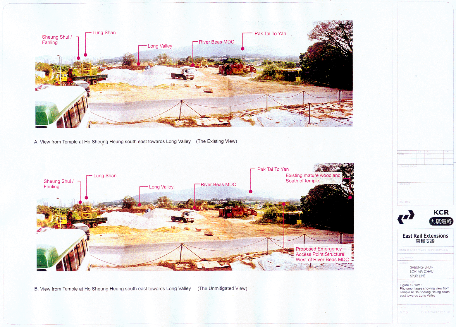
The view from
the temples south of the village of Ho Sheung Heung towards the EAP structure
to the west of the River Beas MDC would be largely screened by intervening
visual obstacles such as the mature woodland to the south and the existing
vegetation on the valley floor. The existing and future views of the valley
floor are presented as Figures
12.10 m and 12.10n in
the Landscape and Visual Impact Assessment Chapter of this EIA and show the
proposed EAP structure being partially visible from this location. Section
12.11.9 of the LVIA describes the impact of the EAP structure on the future
view from the temples, whilst Table 12.4 describes the impacts on the visual
amenity currently enjoyed by visually sensitive receivers within Ho Sheung
Heung (VSR 7). However, through a combination of the use of the proposed tunnel
section, the screening effect of the existing vegetation and the proposed
landscape mitigation measures adjacent to the above ground structures the
residual impacts would be negligible.
11.15
Cultural Heritage Impact Assessment Summary and Conclusions
11.15.1 This chapter presents the results of the assessment of impacts which will result from the construction and operation of the proposed Spur Line on potential archaeological and historical resources.
11.15.2 The results of the assessment can be summarised as follows:
• Valley bottom areas in the north-west and east of the Study Area are wet, marshy or used as ponds. Evaluation of available dry areas revealed deep sterile alluvial deposits only. However, potential exists for historical archaeological material as exhibited by the finding of a Song sherd in Unit 4 and historical material during the NENT Study. This potential is highest in areas adjacent to the village of Ho Sheung Heung and Fung Kong;
• The proposed tunnel option will impact on known and potential archaeological deposits at 2 points only:
(1) East EAP shaft; south of Ho Sheung Heung
(2) Kwu Tung Station box
• Mitigation in the form of field evaluation of the footprint of Kwu Tung station box site; the EAP shaft and associated structures is recommended. Further, a programme of archaeological monitoring during engineering works is recommended for the Kwu Tung station box site. The testing should take place in advance of the construction works. The programme will require auger testing and the excavation of a number of test pits, the number and precise location to be agreed with the AMO. The overall design of the programme must be approved by the AMO and a license to undertake archaeological work obtained by the cultural heritage consultant. Similarly, a complete grave survey will be carried out prior to construction.
• It was determined that no historical structures or villages would be directly impacted by the proposed alignment. A number of villages will be within visual distance of the alignment and associated structures and will thus be indirectly impacted, though none will be closer than approx. 150m.
• Only two historical villages will be indirectly impacted by the alignment: Chau Tau and Ho Sheung Heung. In both cases the villages will experience some aesthetic impacts as they face across agricultural land towards above ground structures associated with the railway. It is recommended that a landscape buffer be created around these structures to minimize adverse impacts.
REFERENCES
Antiquities and
Monuments Office research files
Au Ka-fat, 1997.
General Investigations of the Cultural Finds in Hong Kong: Area 1 (Yuen Long
District). Report submitted to the Antiquities and Monuments Office, Hong Kong.
Binnie (2000).
KCRC Sheung Shui to Lok Ma Chau Spurline EIA (not published).
Bard, S.M., 1988.
In Search of the Past: A Guide to the Antiquities of Hong Kong. Hong Kong:
Urban Council.
ERM-Hong Kong,
1999. Field Evaluation of the Tai Lam Tunnel Portal Area. ERM-Hong Kong.
Geotechnical
Control Office, 1988 a. Geotechnical Area Studies Programme Report V: North New
Territories. Hong Kong: Civil Engineering Services Department.
Geotechnical
Control Office, 1988 b. Geotechnical Area Studies Programme Report IV: North
West New Territories. Hong Kong: Civil Engineering Services Department.
Geotechnical
Control Office, 1989. Geology of the Western New Territories. Hong Kong:Civil
Engineering Services Department.
Hayes, J., 1983.
The Rural Communities of Hong Kong: Studies and Themes. Hong Kong: Nordica
Press.
Irving, Richard
and Brian Morton, 1988. A Geography of the Mai Po Marshes. Hong Kong: Hong Kong
University Press.
Lim, Patricia,
1997. Discovering Hong Kong's Cultural Heritage. Hong Kong: Oxford University
Press.
Lovelace, G.,
1978. Sheung Shui Wa Shan - A Late Prehistoric Riverine Site. Report submitted
to the Antiquities and Monuments Office, Hong Kong.
Maunsell
Consultants Asia Ltd., 2001. Planning and Development Study on North East New
Territories; Technical Paper 13: Environmental Impact Assessment Draft Final
Assessment Report.
Peacock, B.A.V.
and T. Nixon, 1986. Report of the Hong Kong Archaeological Survey. Report
submitted to the Antiquities and Monuments Office, Hong Kong.