Table of Contents
1.1 Description of the Project
2. WATER
QUALITY IMPACT ASSESSMENT
2.7 Sediment Sampling, Elutriation Test and
Particle Size Analysis
2.8 Assessment of Potential Impacts during
Dredging
2.9 Concurrent Dredging/Disposal Activities
2.10 Assessment of Potential Impacts after
Dredging
2.11 Recommended Maximum Dredging Rates and
Proposed Dredging Schedule
2.12 Mitigation Measures and Good Site Practice
3.2 Legislation and Assessment Criteria
3.3 Overview of Habitats in the Study Area
3.6 Intertidal Flora and Fauna
3.9 Impact Identification and Prediction
4. FISHERIES
IMPACT ASSESSMENT
5.8 Monitoring and Audit Requirement
6.3 Potential Sources of Waste
6.6 Potential Impact of Sediment Disposal
7. Environmental
Monitoring and Audit
7.7 Real-Time Reporting of Monitoring Data
List of APPENDICES
Appendix 2 Review of Sediment Quality
Appendix 3 Water Quality Modelling Output
Appendix 4 Implementation Schedule
Appendix 5 Noise Calculations for Grab Dredger Option between 23:00 and 07:00
Appendix
6 EM&A Manual (Construction
Phase) [under a separate cover]
List of Tables
Table 2.2 Water Quality at EPD Routine Monitoring Stations – Wet Season 2000
(April – September)
Table 2.3 Relevant Water Quality Objectives at the Relevant Water Control Zones
Table 2.4 Background SS Concentrations and Tolerance Elevation at Sensitive
Receivers
Table 2.4a Elutriation Test Results
Table 2.5 Estimated Maximum Dredging Rates and Critical Sensitive Receivers
Table 2.10 International Standards for Heavy Metals and Micro-Pollutants in Marine
Environment
Table 2.11 Standards for Heavy Metals and Micro-Pollutants Recommended for This
EIA
Table 2.14 Estimated Maximum Dredging Rates for Worst-Case Scenarios
Table 2.15 Recommended Maximum Dredging Rates for Worst-Case Scenarios
Table 2.16 Recommended Maximum Dredging Rates for Working Zones
Table 2.17 Proposed Working Schedule - Grab
Dredger Option
Table 2.18 Proposed Working Schedule - TSHD Option
Table 3.1 Biomass of Benthic Assemblages from the Lamma Island Area
Table 3.3 Results of Dive Surveys Conducted along West Lamma Coast
Table 3.4 Dive Survey Conditions, 10 December 2001
Table 3.5 Area and Percentage Mortality of Soft and Hard Coral Recorded in the
Three Survey Sites
Table 3.6 A Comparison of Subtidal Conditions Found during SCUBA Surveys in 1998
and 2001
Table 3.7 Summary of Ecological Impact Assessment and Evaluation
Table 5.1 Sound Power Level of Plant Likely to Be Deployed
Table 5.2 Working Schedule and the Allocation of Dredgers for Grab Dredger
Option
Table 5.3 Shortest Distances between the Dredging Area and the NSRs
Table 5.4 Construction Noise Level during
Normal
Working Hours
Table 5.5 Construction Noise Level during Day Time on Holidays
Table 5.6 Construction Noise Level during Evenings
Table 5.7 Construction Noise Level during Night Time
Table 7.1 Action and Limit Levels for Water Quality
LIST OF FIGURES
Figure 1.2 Provisional Dumping Sites and Vessel Movement Restricted Area
Figure 2.1 Environmental Sensitive Receivers
Figure 2.2 Working Zones for Lamma Channel Improvement
Figure 2.3 Illustration of Cage Type Silt Curtain
Figure 3.1 Major Habitat Types around South Lamma
Figure 3.2 OPCF Study Area Showing Survey Sub-Areas and Transect Lines in Hong Kong
Figure 3.5 Dive Survey Sites used by ERM 1998 and for this Study
Figure 3.6 Location of Dive Surveys Conducted by HKIED along the West Lamma Coast
Figure 3.8 Location of Key Porpoise Habitat around the Project Area
Figure 4.1 Fishing Areas around Lamma Island
Figure 7.1 Environmental Monitoring Stations
ABBREVIATIONS
|
AFCD |
- Agricultural, Food and Conservation
Department |
|
CCC |
- Criteria Continuous Concentration |
|
CITES |
- The Convention on the International
Trade in Endangered Species of Wild Fauna and Flora |
|
CMC |
- Criteria Maximum Concentration |
|
DO |
- Dissolved Oxygen |
|
EIA |
- Environmental Impact Assessment |
|
EIAO |
- Environmental Impact Assessment
Ordinance |
|
EIA-TM |
- Technical Memorandum on Environmental
Impact Assessment Process |
|
EM&A |
- Environmental Monitoring and Audit |
|
EPD |
- Environmental Protection Department |
|
HEC |
- Hongkong Electric Company Limited |
|
HKIEd |
- Hong Kong Institute of Education |
|
HKPSG |
- Hong Kong Planning Standards and
Guidelines |
|
IUCN |
- International Union for the Conservation of Nature |
|
LMX |
- Lamma Power Station Extension |
|
NSR |
- Noise Sensitive Receiver |
|
OPCF |
- Ocean Park Conservation Foundation |
|
PD |
- Principal Datum |
|
SOD |
- Sediment Oxygen Demand |
|
SR |
- Sensitive Receiver |
|
SS |
- Suspended Solids |
|
TIN |
- Total Inorganic Nitrogen |
|
TKN |
- Total Kjedahl Nitrogen |
|
TOC |
- Total Organic Carbon |
|
TLC EM&A Manual |
- Environmental Monitoring and Audit
Manual for Backfilling of Marine Borrow Areas at East Tung Lung Chau |
|
TSHD |
- Trailer Suction Hopper Dredger |
|
USACE |
- United States Army Corporate Engineers |
|
USEPA |
- United States Environmental Protection
Agency |
|
WCZ |
- Water Control Zone |
|
WPCO |
- Water Pollution Control Ordinance |
|
WQ |
- Water Quality |
|
WQO |
- Water Quality Objective |
|
WQSR |
- Water Quality Sensitive Receiver |
1.1
Description of the Project
1.1.1
The Hongkong
Electric Company Limited (HEC) is responsible for the generation and supply of
electricity to Hong Kong and Lamma Island.
At present, all electric power is generated from Lamma Power Station
(LPS) which is located on Lamma Island.
LPS, with a total installed capacity of 3,420MW, comprises 2,500MW
coal-fired units for base load operation and 920MW gas turbine units for peak
lopping operation. The annual coal consumption in 2001 is about four million tons.
1.1.2
A coal jetty
designed for 100,000 DWT coal vessels and a dedicated Navigation Channel (the
Channel) have been in operation since the early 1980's to facilitate delivery
of coal from overseas to LPS by ocean going vessels. To ensure an adequate underkeel clearance for safe operation of
coal vessels involved, maintenance dredging was carried out at the Channel in
1989/90 to bring the seabed level to - 16.5mPD. Again due to natural siltation, the water depth at the Channel has
now been reduced to about - 14mPD which is close to the limit for safe navigation of coal vessels of
Panamax size (about 65,000 DWT) which is the smallest class of ocean going coal
vessel in the market.
1.1.3
Even with the
first new 300MW gas-fired unit in service at Lamma Power Station Extension, the
coal-fired units of LPS still have to operate to meet the majority of
electricity demand. The annual coal consumption is around four
million tons.
1.1.4
As the siltation is building up and in view of the importance to have in
place a safe navigation channel with adequate water depth for ocean going coal
vessels, maintenance dredging must be carried out in 2003. Otherwise, coal supply to the LPS will
be seriously hampered and the
reliability of electricity supply will be jeopardized. The proposed maintenance dredging work involves deepening the existing Channel to - 16mPD
with an estimated total dredging
volume of 2.98 million m3.
1.1.5
The
Project Area is illustrated in Figure 1.1. The grey area shows the limit of the Channel
where dredging will be required under this Project. According to the latest
bathymetric survey of the Channel, there is already sufficient water depth and
no dredging will be required in the remaining section of the Channel in the
south (beyond the grey area in Figure 1.1).
1.1.6
The
dredging is scheduled to take place between May 2003 and December 2003. In order to minimise the dredging period thus
minimising the period of potential disturbance to environment and to suit the
normal operating mode of dredgers, it is planned that the dredgers will be operating on a 24-hour basis
during the dredging period. Marine
vessels will transport the dredged sediment to the Government approved disposal
sites at East Ninepin, East Tung Lung Chau and East Sha Chau as shown in Figure 1.2.
1.1.7
Coal
ships currently deliver about six shipments of coal per month to the Lamma
Power Station via the Channel. All
dredging works will be temporarily suspended when coal ships are navigating the
Channel.
1.1.8
As
the total dredging volume exceeds 500,000m3, the dredging operation
of the Channel improvement is a designated project according to the
Environmental Impact Assessment (EIA) Ordinance, Schedule 2, Part I, C.12. A Project Profile was submitted by HEC to
EPD on 11 June 2001 for application of an EIA Study Brief, which (Brief No.
ESB-078/2001) was issued by EPD on 23 July 2001. Hyder Consulting Ltd was commissioned by HEC to undertake the EIA
Study in accordance with the EIA Study Brief.
1.2.1
The
purpose of this EIA is to provide information on the nature and extent of
potential environmental impacts arising from the proposed Project and other
projects taking place concurrently, with specific objectives as follows:
(a) To
describe the proposed Project and associated works together with the
requirements for carrying out the proposed Project;
(b) To consider alternative method(s) for
the dredging work and design to ensure safe delivery of fuel to the Power
station; and to compare the environmental benefits and dis-benefits of each of
the method(s) and design in selecting a preferred one;
(c) To identify and describe elements of the
community and environment likely to be affected by the proposed Project and/or
likely to cause adverse impacts to the proposed Project, including natural and
man-made environment;
(d) To propose the provision of
infrastructure or mitigation measures so as to minimize pollution,
environmental disturbance and nuisance during construction and operation of the
proposed Project;
(e) To identify, predict and evaluate the
residual (i.e. after practicable mitigation) environmental impacts and the
cumulative effects expected to arise during the construction and operation
phases of the proposed Project in relation to the sensitive receivers (SRs) and
potential affected uses;
(f) To identify, assess and specify
methods, measures and standards, to be included in the detailed design,
construction and operation of the proposed Project which are necessary to
mitigate these environmental impacts and reducing them to acceptable levels;
(g) To investigate the extent of the
secondary environmental impacts that may arise from the proposed mitigation
measures, and to identify the constraints associated with the mitigation
measures recommended in the EIA study as well as the provision of any necessary
modification;
(h) To identify, within the study area, any
individual project(s) that fall under Schedule 2 of the EIA Ordinance (EIAO);
to ascertain whether the findings of this EIA study have adequately addressed
the environmental impacts of those projects; and where necessary to identify
the outstanding issues that need to be addressed in any further detailed EIA
study; and
(i) To design and specify environmental
monitoring and audit (EM&A) requirements, if required, to ensure the
implementation and the effectiveness of the environmental protection and
pollution control measures adopted.
1.3.1
Following
this introductory section, Section 2 presents an assessment of the
potential impacts on water quality (WQ).
Potential WQ sensitive receivers (WQSRs) are identified. The baseline WQ conditions at those SRs are
collated and the potential impacts of the Project on the SRs assessed.
1.3.2
Based
on the potential WQ impacts, an assessment of the potential impacts on the
marine ecology and fisheries has been carried out and the findings are
presented in Sections 3 and 4.
1.3.3
The
potential noise impact generated from the dredgers and barges to be deployed
for the works is assessed in Section 5, taking into account the other
ongoing noise generating activities around the area.
1.3.4
The
management and disposal of the dredged marine sediment is presented in Section
6. Section 7 outlines the
Environmental Monitoring and Audit (EM&A) requirements recommended from
this EIA and the main conclusions, recommendations and environmental outcomes
of the EIA Study are summarised in Section 8.
1.3.5
Detailed
technical information generated from this EIA Study is provided in the Appendices.
1.3.6
Appendix
1 presents the
methodology, sampling location and detailed testing results of the Elutriation
Test specifically conducted for this EIA Study, which aims to quantify the
potential release of various contaminants from the seabed sediment into the water
column in the vicinity of dredging.
1.3.7
The
sediment quality data collected in and around the Channel is presented in Appendix
2.
1.3.8
Detailed
graphical outputs from the water quality modelling are provided in Appendix
3. An Implementation Schedule for
the mitigation measures and good site practice recommended from this EIA Study
is presented in Appendix 4.
1.3.9
Detailed
Noise Calculations are presented in Appendix 5 and an EM&A Manual
(Construction Phase) is presented in Appendix 6 (under a separate
cover).
2.1.1 The Lamma Power Station Navigation Channel Improvement Work involves dredging of marine sediment within the existing Navigation Channel and disposal of the dredged sediment.
2.1.2 During the dredging operation, marine sediment leaking through the dredger will be released into the water column, thus leading to the elevation of the suspended solids (SS) level in the marine water. The coarse material, such as sand and gravel, of the released sediment will settle quickly back to the seabed close to the dredging site. However fine particles, such as silt and clay, together with any contaminants they may carry, will be transported away from the site by oceanic currents and tides, which may then affect WQSRs.
2.1.3 The potential WQSRs have been identified. The potential impact of the dredging operation on the SRs in terms of both pollution elevation and sediment deposition have been quantified, taking into account con-current dredging and disposal activities during the same period. Necessary mitigation measures have been recommended.
2.2.1 The WQSRs have been chosen based on the EIA study of the Lamma Power Station Extension completed in 1998 and the unique features of this dredging operation. Marine sediment sampling and elutriation test (following the USACE recommended methods) of the samples collected have been performed to determine the degree of mobilization of any likely contaminants. WQ modelling has then been carried out to ascertain the potential elevation of water pollution in terms of various WQ parameters at the WQSRs. As the WQ model developed from the earlier EIA study of the Lamma Power Station Extension is intended for the same Project Area, and has been fully calibrated and verified, it has also been adopted for this EIA study. Based on the results of the modelling, the elutriation tests and the baseline WQ conditions, the maximum dredging rates which would ensure no unacceptable environmental impacts are estimated.
2.3.1 The following legislation is applicable to the evaluation of WQ impacts associated with the dredging and disposal of marine sediment.
· Environmental Impact Assessment Ordinance and Technical Memorandum on Environmental Impact Assessment Process (EIA-TM)
· Water Pollution Control Ordinance (WPCO)
· Work Branch Technical Circular No. 3/2000, Management of Dredged/Excavated Sediment (WBTC No. 3/2000)
2.3.2 The WPCO is the primary legislation for the control of water pollution and WQ in Hong Kong. Under WPCO, Hong Kong waters are divided into 10 Water Control Zones (WCZs) each zone has a designated set of statutory Water Quality Objectives (WQOs). The Lamma Power Station Navigation Channel and most of the potential WQSRs lie within the Southern WCZ. The WQOs for these WCZs are the evaluation criteria for assessing the WQ impacts during dredging activities.
2.4.1 The dredging activities of the Navigation Channel will have the potential to directly affect WQ in the water along the western coast of Lamma Island. Beneficial uses have been defined in accordance with the requirements of the Hong Kong Planning Standards and Guidelines (HKPSG), which have been transposed into the EIA Technical Memorandum (TM). WQSRs have been identified in these potentially affected areas under the broad designations of gazetted and non-gazetted bathing beaches, water intakes, fish culture zones and sites of ecological value. The following list of WQSRs are identified in each of the categories:
Gazetted Bathing Beaches: Hung Shing Ye Beach and Lo So Shing Beach.
Water Intakes: Kennedy Town WSD Intake, Sha Wan Drive Intake, Queen Mary Hospital Intake, Wah Fu Estate Intake and HEC Lamma Power Station Intake. A new seawater intake at Cyberport is expected to start operating towards late 2002. The water intake is close to the seawater intake at Wah Fu Estate and is between the seawater intakes at Wah Fu Estate and at Queen Mary Hospital. The impact of this project on the seawater intake at Cyberport is considered to be acceptable as long as the impact on those at Wah Fu Estate and Queen Mary Hospital is acceptable.
Fish Culture Zones: Lo Tik Wan Fish Culture Zone and Sok Kwu Wan Fish Culture Zone.
Sites of Ecological Interest: Kau Yi Chau (fish fry nursery area), Pak Kok (corals present), Shek Kok Tsui (corals present), Luk Chau (corals present) and south Lamma water (finless porpoise habitat). Due to its ecological importance, the south Lamma water could be potentially designated as a marine park. Two points, South Lamma 1 and South Lamma 2, which are situated in the closest part of the south Lamma water to the works area, have been chosen to facilitate the quantification of the potential WQ impact of this Project on the south Lamma water. As long as the impact on this part of the water is acceptable, the impact on the other parts of the south Lamma water will be less and therefore also acceptable.
2.4.2
There are a number of EPD routine
water monitoring stations around the Study Area. The WQ data monitored from those stations has been used in this EIA
to derive the baseline WQ conditions at the identified WQSRs. The locations of
the above WQSRs and the EPD WQ monitoring stations are shown
in Figure 2.1.
Hydrodynamic Conditions
2.5.1 The Channel, located at the western side of the Lamma Power Station and extending along the outskirt of Ha Mei Wan, is within the West Lamma Channel. The residual flow through the West Lamma Channel is towards the south. The average residual flow through a cross-section from Cheung Chau Island in the west to Shek Kok Tsui (just to the north of Lamma Power Station) in the east is 700 m3/s and 2800 m3/s approximately during the dry and the wet season respectively [1]. The average tidal flow through the cross-section in the dry season is 26,000 m3/s at the flood tide and 33,800 m3/s at the ebb tide. In the wet season, the average flow is increased to 27,700 m3/s at the flood tide and 40,700 m3/s at the ebb tide.
2.5.2 The tidal currents in the Channel with a peak speed of just over 0.5 m/s, are predominantly from the southeast to the northwest at the flood tide and in the opposite direction during the ebb tide, i.e. from the northwest towards the southeast.
Water Quality Conditions
2.5.3 The Channel lies within the Southern WCZ. EPD carries out routine monitoring of marine WQ at the nearby stations, namely SM4, SM5, SM6, SM7, WM1 and WM2 as shown in Figure 2.1.
2.5.4 A number of EPD routine monitoring stations are in the vicinity of the dredging site, of which the closest is less than 1 km to the east of the Channel. Relevant WQ data for this site, SM5, and other nearby stations around Lamma Island and within the Southern and Western Buffer WCZs are summarised in Tables 2.1 and 2.2 for the dry (October to March) and wet (April to September) season respectively. This data was monitored in 2000. It is the most up to date information from EPD and is therefore used in this EIA to represent the baseline WQ conditions. All monitoring stations are within 8 km of the Project Area.
|
WQ Parameter |
SM3 |
SM4 |
SM5 |
SM6 |
SM7 |
WM1 |
WM2 |
|
DO (mg/L) |
6.99 (A) 6.69 (S) 7.17(B) (5.58-7.77) |
6.80 (A) 6.57 (S) 6.95 (B) (5.50-7.61) |
6.75 (A) 6.51 (S) 6.93 (B) (6.08-7.33) |
7.09 (A) 7.08 (S) 7.13 (B) (5.74-7.63) |
6.92 (A) 6.83 (S) 7.00 (B) (5.33-8.63) |
6.72 (A) 6.54 (S) 6.81 (B) (4.48-7.80) |
6.35 (A) 6.19 (S) 6.45 (B) (4.19-7.88) |
|
DO (% Sat.) |
92.08 (83.63-97.77) |
89.81 (82.46-94.51) |
89.53 (83.82-98.24) |
93.42 (86.31-98.33) |
91.08 (79.72-109.8) |
88.88 (66.65-100.2) |
83.93 (62.51-99.94) |
|
BOD5 (mg/L) |
0.49 (0.10-1.37) |
0.78 (0.35-1.47) |
0.93 (0.34-2.17) |
0.91 (0.31-2.13) |
1.08 (0.41-2.90) |
0.75 (0.15-2.00) |
0.85 (0.33-1.87) |
|
NH4 (mg/L) |
0.03 (0.01-0.07) |
0.05 (0.01-0.10) |
0.03 (0.01-0.05) |
0.03 (0.01-0.05) |
0.05 (0.02-0.11) |
0.05 (0.03-0.06) |
0.08 (0.02-0.13) |
|
NH3 (mg/L) |
0.001 (0.000-0.002) |
0.001 (0.000-0.002) |
0.001 (0.000-0.001) |
0.001 (0.000-0.002) |
0.002 (0.001-0.002) |
0.001 (0.000-0.002) |
0.002 (0.000-0.004) |
|
NO2 (mg/L) |
0.02 (0.01-0.08) |
0.02 (0.01-0.07) |
0.02 (0.01-0.04) |
0.03 (0.01-0.10) |
0.04 (0.01-0.16) |
0.04 (0.01-0.13) |
0.05 (0.01-0.19) |
|
NO3 (mg/L) |
0.10 (0.05-0.14) |
0.10 (0.05-0.16) |
0.09 (0.04-0.13) |
0.10 (0.03-0.15) |
0.12 (0.03-0.26) |
0.09 (0.04-0.15) |
0.12 (0.06-0.17) |
|
SS (mg/L) |
6.06 (1.13-10.70) |
7.11 (0.87-26.53) |
5.62 (1.30-10.87) |
8.46 (1.67-18.37) |
5.37 (2.13-12.83) |
6.29 (1.80-13.00) |
8.38 (1.47-22.33) |
|
TIN (mg/L) |
0.15 (0.10-0.20) |
0.17 (0.11-0.21) |
0.14 (0.09-0.16) |
0.15 (0.10-0.28) |
0.21 (0.08-0.45) |
0.18 (0.10-0.27) |
0.25 (0.17-0.36) |
|
TN (mg/L) |
0.27 (0.19-0.34) |
0.29 (0.21-0.35) |
0.23 (0.18-0.27) |
0.27 (0.20-0.42) |
0.33 (0.18-0.57) |
0.30 (0.26-0.39) |
0.40 (0.30-0.49) |
Note: 1. Data presented are depth-averaged, except
as specified.
2.
Data presented are Dry Season arithmetic mean.
3.
Data enclosed in brackets indicate the ranges.
4.
Shaded cells indicate non-compliance with WQOs.
5.
(A), (S) and (B) represented the value of
depth-averaged, surface layer and bottom layer respectively.
2.5.5 The data in Tables 2.1~2.3 shows that the baseline WQ in the vicinity of the Channel was generally good, with compliance of WQOs for dissolved oxygen and unionised ammonia being achieved in both seasons at all monitoring stations. The total inorganic nitrogen (TIN) exceeded the WQO limits at all five stations in Southern WCZ. It is worth noting that the WQO for TIN is not exceeded at Stations WM1 and WM2, even though the average concentration was higher than those in Southern WCZ. This is because the TIN level in the WQOs for Western Buffer WCZ was higher than that for the Southern WCZ.
Table 2.2 Water Quality at EPD Routine Monitoring Stations – Wet Season 2000 (April – September)
|
WQ Parameter |
SM3 |
SM4 |
SM5 |
SM6 |
SM7 |
WM1 |
WM2 |
|
DO (mg/L) |
5.95 (A) 6.75 (S) 5.40 (B) (4.91-7.14) |
6.24 (A) 6.41 (S) 5.82 (B) (4.62-8.18) |
7.28 (A) 7.59 (S) 6.56 (B) (4.82-9.24) |
6.47 (A) 7.61 (S) 5.31 (B) (5.04-8.24) |
7.03 (A) 7.11 (S) 6.59 (B) (4.77-10.31) |
5.54 (A) 6.22 (S) 4.93 (B) (3.89-6.81) |
5.74 (A) 6.06 (S) 5.43 (B) (4.15-8.06) |
|
DO (% Sat.) |
86.95 (72.35-107.92) |
91.94 (68.10-123.65) |
107.58 (71.50-139.19) |
95.30 (74.69-124.47) |
103.18 (69.95-154.10) |
80.31 (55.38-99.83) |
83.12 (59.50-120.78) |
|
BOD5 (mg/L) |
0.66 (0.37-0.81) |
0.77 (0.61-1.21) |
1.31 (0.78-2.63) |
1.11 (0.70-2.31) |
1.33 (0.58-3.07) |
0.82 (0.22-1.33) |
0.94 (0.35-1.90) |
|
NH4 (mg/L) |
0.04 (0.02-0.10) |
0.06 (0.03-0.10) |
0.03 (0.01-0.06) |
0.04 (0.02-0.08) |
0.07 (0.03-0.13) |
0.04 (0.02-0.06) |
0.07 (0.02-0.13) |
|
NH3 (mg/L) |
0.003 (0.001-0.008) |
0.003 (0.002-0.008) |
0.002 (0.000-0.006) |
0.003 (0.001-0.007) |
0.004 (0.002-0.011) |
0.002 (0.001-0.003) |
0.003 (0.001-0.006) |
|
NO2 (mg/L) |
0.02 (0.002-0.032) |
0.02 (0.01-0.04) |
0.02 (0.00-0.04) |
0.02 (0.00-0.04) |
0.03 (0.01-0.04) |
0.02 (0.00-0.05) |
0.04 (0.01-0.08) |
|
NO3 (mg/L) |
0.07 (0.01-0.15) |
0.09 (0.02-0.22) |
0.12 (0.00-0.31) |
0.01 (0.01-0.26) |
0.17 (0.04-0.30) |
0.12 (0.03-0.23) |
0.19 (0.11-0.26) |
|
SS (mg/L) |
5.48 (3.03-8.83) |
3.55 (1.47-6.17) |
3.71 (2.63-6.10) |
3.83 (2.80-5.37) |
4.89 (2.57-6.53) |
4.81 (1.83-7.00) |
3.49 (1.37-5.73) |
|
TIN (mg/L) |
0.13 (0.05-0.22) |
0.16 (0.10-0.30) |
0.17 (0.02-0.39) |
0.18 (0.03-0.34) |
0.26 (0.19-0.36) |
0.19 (0.07-0.32) |
0.30 (0.19-0.43) |
|
TN (mg/L) |
0.24 (0.13-0.34) |
0.29 (0.17-0.49) |
0.33 (0.10-0.63) |
0.32 (0.11-0.58) |
0.47 (0.27-0.86) |
0.29 (0.17-0.42) |
0.42 (0.29-0.55) |
Note: 1. Data presented are depth-averaged, except
as specified.
2. Data presented are Wet Season arithmetic
mean.
3. Data enclosed in brackets indicate the
ranges.
4. Shaded cells indicate non-compliance with
WQOs.
5 (A), (S)
and (B) represented the value of depth-averaged, surface layer and bottom layer
respectively.
Table 2.3 Relevant Water Quality Objectives at the Relevant Water Control Zones
|
Locations
of WQSR |
Southern
WCZ |
Western
Buffer WCZ |
Victoria
Harbour (Phase 3) WCZ |
|
WQSR ID (see Fig 2.1) |
1, 7 - 15 |
3-6 |
2 |
|
PH |
6.5 – 8.5 |
||
|
Dissolved Oxygen (depth average, 90% of the sampling occasion during the year) |
4 mg/L |
||
|
Dissolved Oxygen (within 2 m from seabed, 90% of the sampling occasion during the year) |
2 mg/L |
||
|
Un-Ionised Ammonia Nitrogen (annual average) |
0.021 mg/L |
||
|
Total Inorganic Nitrogen (annual depth average) |
0.1 mg/L |
0.4 mg/L |
0.4 mg/L |
|
Suspended Solids |
< 30% increase over the ambient level |
||
2.6.1 Impacts from SS may be caused by sediment plumes being transported to SRs, such as water intakes, bathing beaches and areas of high ecological value, leading to the elevation of the SS levels at the SRs. The level of elevation will determine whether the impact is acceptable. The WQOs in terms of SS for the Southern and Western Buffer WCZs are defined as being an allowable maximum elevation of 30% above the background for bathing beaches and sites of ecological interest. Following recent research [29] by City University for AFCD, a maximum SS level of 50mg/l is recommended for the marine fish culture zones. The maximum SS levels allowed for the water intakes are 100mg/l for HEC’s Lamma Power Station cooling water intake, 20mg/l for the remaining water intakes. Based on the allowable maximum SS levels and the baseline SS levels, the SS tolerant elevation can be determined as in Table 2.4. As the seawater intakes are normally located in the mid-depth or above, the assessment criteria for the seawater intakes has been based on the pollution levels at the surface layer and the depth-averaged concentrations.
2.6.2 The WQOs in terms of other WQ parameters for the WQSRs have been taken as the same as those for the respective WCZs.
2.6.3 Silt and clay, also called cohesive sediment, will form large particles by the process of flocculation after being released into the water column, which will then settle back to the seabed, resulting in a smothering effect. This smothering effect can be detrimental to the corals found near the western coast of Lamma Island. Following the EIA for Sand Dredging at the West Po Toi Marine Borrow Area [30], a limit on the sedimentation rate of 0.1kg/m2/day was applied to this EIA in view of the ecological interests found in and around the area.
2.6.4 With reference to a previous EIA study for a 1,800MW Gas-Fired Power station at Lamma Extension [3], the background SS value for this EIA has been represented by the 90th percentile of the reported concentrations.
2.6.5 EPD routine WQ monitoring data has been used as the source of reported concentrations, with the monitoring station nearest to each SR being defined as representative of that SR. The predicted maximum SS elevation resulting from the dredging has been compared to the SS tolerance values in Table 2.4 and the predicted maximum concentration elevation of other pollutants plus the baseline level has been compared to Table 2.3, to determine the acceptability of the WQ impacts.
Table 2.4 Background SS Concentrations and Tolerance Elevation at Sensitive Receivers
|
SRs (Relevant Monitoring Station) |
Dry Season |
Wet Season |
|||
|
90th Percentile |
Tolerance Elevation (mg/l) |
90th Percentile |
Tolerance Elevation (mg/l) |
||
|
Luk Cha (SM3) |
Aa |
9.18 |
2.75 |
8.07 |
2.42 |
|
Sb |
6.85 |
2.06 |
4.30 |
1.29 |
|
|
Bc |
14.50 |
4.35 |
21.00 |
6.30 |
|
|
Lo Tik Wan Fish Culture Zoned (SM3) |
A |
9.18 |
40.82 |
8.07 |
41.93 |
|
S |
6.85 |
43.15 |
4.30 |
45.7 |
|
|
B |
14.50 |
35.5 |
21.00 |
29.00 |
|
|
Sok Kwu Wan Fish Culture Zoned (SM4) |
A |
15.92 |
34.08 |
5.18 |
44.82 |
|
S |
5.30 |
44.7 |
4.80 |
45.20 |
|
|
B |
25.85 |
24.15 |
7.75 |
42.25 |
|
|
Hung Shing Ye Beach Lo So Shing Beach S. Lamma 1 S. Lamma 2 (SM5) |
A |
8.65 |
2.60 |
5.42 |
1.63 |
|
S |
6.00 |
1.80 |
4.35 |
1.31 |
|
|
B |
12.30 |
3.69 |
6.10 |
1.83 |
|
|
Sha Wan Drive Intakee Queen Mary Hospital Intakee Wah Fu Estate Intakee (WM1) |
A |
11.67 |
8.33 |
6.95 |
13.05 |
|
S |
7.00 |
13.00 |
3.60 |
16.40 |
|
|
Pak Kok Shek Kok Tsui (WM1) |
A |
11.67 |
3.50 |
6.95 |
2.09 |
|
S |
7.00 |
2.10 |
3.60 |
1.08 |
|
|
B |
16.50 |
4.95 |
14.00 |
4.20 |
|
|
Kennedy Town WSD Intakee (WM2) |
A |
19.00 |
1.00 |
5.10 |
14.90 |
|
S |
15.50 |
4.50 |
4.55 |
15.45 |
|
|
Kau Yi Chau (WM2) |
A |
19.00 |
5.70 |
5.10 |
1.53 |
|
S |
15.50 |
4.65 |
4.55 |
1.37 |
|
|
B |
25.50 |
7.65 |
5.85 |
1.76 |
|
|
HEC Power Station Intake f (SM5) |
A |
9.18 |
90.82 |
8.07 |
91.93 |
|
S |
6.85 |
93.15 |
4.30 |
95.70 |
|
Note: a. A represents depth-averaged
b. S represents surface layer
c. B represents bottom layer
d. Fish Culture Zones can
tolerate a SS level of up to 50mg/l according to AFCD
e. Flushing seawater intakes can
tolerate a SS level of up to 20mg/l
f. HEC Power Station cooling water
intake can tolerate a SS level of up to 100mg/l according to HEC.
2.7
Sediment Sampling, Elutriation Test and Particle Size Analysis
2.7.1 An elutriation test has been carried out as part of this EIA study to assess the elutriation potential of various contaminants in the sediment during dredging.
2.7.2 Under normal conditions, the contaminants would bind firmly with the bottom sediment and remain in the seabed. However, it is possible that these contaminants might be released into marine water if mechanical actions such as dredging activities take place, thus affecting the ambient marine WQ.
2.7.3 The objective of carrying out elutriate testing was to investigate the potential for the sediment-bonded pollutants being released into the ambient marine water (in the immediate vicinity of dredging) during dredging activities for the Project. ALS Environmental, a laboratory accredited by HOKLAS, was appointed to conduct sample collection and elutriation analysis.
2.7.4 Sediment samples were collected in December 2001 from the Project Area at three locations (Sample A - 828240E, 808540N; Sample B - 828540E, 807270N and Sample C - 828780E, 806000N) as shown in Figure 2.1 using grab samplers. Representative blank marine water samples were also collected for the test. The three sediment samples were homogenized in the laboratory and extracted with the collected marine water in accordance with the elutriation method as recommended by USACE.
2.7.5 The sampling locations were chosen so that they are representative of the Channel and are close to the three dredging locations (representing the worst-case scenarios) to be modelled for WQ assessment.
The following WQ parameters were analyzed:
·
Nitrogen Nutrients
Ammonia nitrogen (NH3-N and NH4-N), Nitrite (NO2-N), Nitrate (NO3-N), Organic Nitrogen, Total Kjeldahl Nitrogen (TKN) and Total Inorganic Nitrogen (TIN).
·
Heavy Metals
Silver, Arsenic, Cadmium, Chromium, Copper, Nickel, Lead, Zinc and Mercury.
·
Micro-Pollutants
PCBs, PAHs, TBT and chlorinated pesticides.
·
Five-Day Sediment Oxygen Demand
(SOD5)
2.7.6 Unlike the above parameters for which the analysis was carried out on the mixture of sediment and water, sediment samples were analysed for SOD5.
2.7.7 The detection limits for the various WQ parameters were established based on the review of the international marine WQ standards which will be discussed later in this Report. A summary of the elutriation test results is given in Table 2.4a.
2.7.8 All heavy metals were found to be below the detection limits for all samples.
2.7.9 TBT, all PAHs, PCBs and chlorinated pesticides were also below the detection limit for all samples.
2.7.10 SOD5 were found to be 453, 706 and 380 mgO2/kg (dry weight sediment) for the samples collected at the locations A, B and C respectively.
Table 2.4a Elutriation Test Results
|
Parameters |
Unit |
Sample
A |
Sample
B |
Sample
C |
Blank
Water |
|
pH Value @ 25'C |
|
7.6 |
7.6 |
7.8 |
8.1 |
|
Redox Potential |
mV |
266 |
263 |
262 |
260 |
|
Silver |
ug/L |
<1 |
<1 |
<1 |
<1 |
|
|
|
|
|
|
|
|
Heavey
Metals |
|
|
|
|
|
|
Arsenic |
ug/L |
<10 |
<10 |
<10 |
<10 |
|
Cadmium |
ug/L |
<0.5 |
<0.5 |
<0.5 |
<0.5 |
|
Chromium |
ug/L |
<5 |
<5 |
<5 |
<5 |
|
Copper |
ug/L |
<1 |
<1 |
<1 |
<1 |
|
Nickel |
ug/L |
<1 |
<1 |
<1 |
<1 |
|
Lead |
ug/L |
<1 |
<1 |
<1 |
<1 |
|
Zinc |
ug/L |
<10 |
<10 |
<10 |
<10 |
|
Mercury |
ug/L |
<0.05 |
<0.05 |
<0.05 |
<0.05 |
|
|
|
|
|
|
|
|
Nutrients |
|
|
|
|
|
|
Ammonia as N |
mg/L |
1.76 |
2.74 |
1.23 |
0.01 |
|
Nitrite + Nitrate as N |
mg/L |
0.02 |
0.02 |
0.02 |
0.11 |
|
Organic Nitrogen as N |
mg/L |
0.4 |
0.3 |
0.7 |
0.4 |
|
Total Kjeldahl Nitrogen as N |
mg/L |
2.2 |
3 |
1.9 |
0.4 |
|
Total Inorganic Nitrogen |
mg/L |
1.78 |
2.76 |
1.25 |
0.12 |
|
|
|
|
|
|
|
|
PCBs |
|
|
|
|
|
|
PCB8 |
ug/L |
<1 |
<1 |
<1 |
<1 |
|
PCB18 |
ug/L |
<1 |
<1 |
<1 |
<1 |
|
PCB28 |
ug/L |
<1 |
<1 |
<1 |
<1 |
|
PCB44 |
ug/L |
<1 |
<1 |
<1 |
<1 |
|
PCB52 |
ug/L |
<1 |
<1 |
<1 |
<1 |
|
PCB66 |
ug/L |
<1 |
<1 |
<1 |
<1 |
|
PCB77 |
ug/L |
<1 |
<1 |
<1 |
<1 |
|
PCB101 |
ug/L |
<1 |
<1 |
<1 |
<1 |
|
PCB105 |
ug/L |
<1 |
<1 |
<1 |
<1 |
|
PCB118 |
ug/L |
<1 |
<1 |
<1 |
<1 |
|
PCB126 |
ug/L |
<1 |
<1 |
<1 |
<1 |
|
PCB128 |
ug/L |
<1 |
<1 |
<1 |
<1 |
|
PCB138 |
ug/L |
<1 |
<1 |
<1 |
<1 |
|
PCB153 |
ug/L |
<1 |
<1 |
<1 |
<1 |
|
PCB169 |
ug/L |
<1 |
<1 |
<1 |
<1 |
|
PCB170 |
ug/L |
<1 |
<1 |
<1 |
<1 |
|
PCB180 |
ug/L |
<1 |
<1 |
<1 |
<1 |
|
PCB187 |
ug/L |
<1 |
<1 |
<1 |
<1 |
|
PCB195 |
ug/L |
<1 |
<1 |
<1 |
<1 |
|
PCB206 |
ug/L |
<1 |
<1 |
<1 |
<1 |
|
PCB209 |
ug/L |
<1 |
<1 |
<1 |
<1 |
|
|
|
|
|
|
|
|
ORGANOCHLORINE PESTICIDES |
|
|
|
|
|
|
alpha-BHC |
ug/L |
<0.5 |
<0.5 |
<0.5 |
<0.5 |
|
beta- & gamma-BHC |
ug/L |
<1 |
<1 |
<1 |
<1 |
|
delta-BHC |
ug/L |
<0.5 |
<0.5 |
<0.5 |
<0.5 |
|
Heptachlor |
ug/L |
<0.5 |
<0.5 |
<0.5 |
<0.5 |
|
Aldrin |
ug/L |
<0.5 |
<0.5 |
<0.5 |
<0.5 |
|
Heptachlor epoxide |
ug/L |
<0.5 |
<0.5 |
<0.5 |
<0.5 |
|
Endosulfan 1 |
ug/L |
<0.5 |
<0.5 |
<0.5 |
<0.5 |
|
Dieldrin |
ug/L |
<0.5 |
<0.5 |
<0.5 |
<0.5 |
|
4,4'-DDE |
ug/L |
<0.5 |
<0.5 |
<0.5 |
<0.5 |
|
Endrin |
ug/L |
<0.5 |
<0.5 |
<0.5 |
<0.5 |
|
Endosulfan 2 |
ug/L |
<0.5 |
<0.5 |
<0.5 |
<0.5 |
|
4,4'-DDD |
ug/L |
<0.5 |
<0.5 |
<0.5 |
<0.5 |
|
Endrin aldehyde |
ug/L |
<0.5 |
<0.5 |
<0.5 |
<0.5 |
|
Endosulfan sulfate |
ug/L |
<0.5 |
<0.5 |
<0.5 |
<0.5 |
|
4,4'-DDT |
ug/L |
<2 |
<2 |
<2 |
<2 |
|
Endrin ketone |
ug/L |
<0.5 |
<0.5 |
<0.5 |
<0.5 |
|
Methoxychlor |
ug/L |
<2 |
<2 |
<2 |
<2 |
|
Cypermethrins |
ug/L |
<0.5 |
<0.5 |
<0.5 |
<0.5 |
|
|
|
|
|
|
|
|
POLYNUCLEAR AROMATICS |
|
|
|
|
|
|
Naphthalene |
ug/L |
<2 |
<2 |
<2 |
<2 |
|
Acenaphthylene |
ug/L |
<2 |
<2 |
<2 |
<2 |
|
Acenaphthene |
ug/L |
<2 |
<2 |
<2 |
<2 |
|
Fluorene |
ug/L |
<2 |
<2 |
<2 |
<2 |
|
Phenanthrene |
ug/L |
<2 |
<2 |
<2 |
<2 |
|
Anthracene |
ug/L |
<2 |
<2 |
<2 |
<2 |
|
Fluoranthene |
ug/L |
<2 |
<2 |
<2 |
<2 |
|
Pyrene |
ug/L |
<2 |
<2 |
<2 |
<2 |
|
Benz(a)anthracene |
ug/L |
<2 |
<2 |
<2 |
<2 |
|
Chrysene |
ug/L |
<2 |
<2 |
<2 |
<2 |
|
Benzo(b) & (k)fluoranthene |
ug/L |
<4 |
<4 |
<4 |
<4 |
|
Benzo(a)pyrene |
ug/L |
<2 |
<2 |
<2 |
<2 |
|
Indeno(1.2.3-cd)pyrene |
ug/L |
<2 |
<2 |
<2 |
<2 |
|
Dibenz(a.h)anthracene |
ug/L |
<2 |
<2 |
<2 |
<2 |
|
Benzo(g.h.i)perylene |
ug/L |
<2 |
<2 |
<2 |
<2 |
|
|
|
|
|
|
|
|
ORGANOTIN COMPOUNDS |
|
|
|
|
|
|
Tributyltin - Soluble |
ng Sn/L |
<5 |
<5 |
<5 |
<5 |
2.7.11 The majority of the TIN (in excess of 98%) consists of ammoniacal nitrogen. There is significant elevation of all nitrogen components over the background levels except for NO2-N and NO3-N.
2.7.12 The level of NO2-N and NO3-N in the elutriation samples was found to be lower than the background levels, which is believed to be due to the sediment, on mixing with the seawater, acting as an oxygen absorption media in the mixing process which converts part of NO2-N and NO3-N into NH3-N.
2.7.13 In addition, the sediment samples were analysed for particle size distributions. All samples showed that 95% or more of the sediment was silt and clay.
2.7.14 The details of the sampling methodology and the elutriation testing results are provided in Appendix 1.
2.7.15 During the period from 1994 to 1998 three sets of sediment quality data were collected in and around the Channel. A summary of the sediment quality data is provided in Appendix 2. All measured contaminant levels of the samples are below the Lower Chemical Exceedance Level (LCEL) as defined in the Works Bureau Technical Circular (WBTC) No. 3/2000. Data from these three sediment quality studies indicated there have been no significant changes in sediment quality during the 4-year period and the sediment in and around the Channel belongs to Category L. An earlier study [3] also confirmed that the marine sediment at the site of the Lamma Power Station Extension, which is close to the northern section of the Channel, is uncontaminated.
2.8
Assessment of Potential Impacts during Dredging
The Water Quality Model
2.8.1 The WQ effect has been assessed using WQ modelling. The hydrodynamic and WQ model constructed using Delft3D for a previous EIA study, Environmental Impact Assessment of a 1,800MW Gas-Fired Power Station at Lamma Extension [3], has been adopted for the current study. The coverage and the computational grid system of the model are shown in Figure A3.1 in Appendix 3.
2.8.2 Due to lack of site specific data, a sediment settling velocity of 2m/d, derived from the calibration and verification of the Upgraded Model for Hong Kong waters, has been adopted for this EIA.
2.8.3 The dredging period is scheduled for between May 2003 and December 2003, covering both the dry and wet seasons. As the tidal circulation patterns in the vicinity of the Channel differs significantly between the two seasons, the model has been run for a typical 15-day spring to neap tidal cycle each for the dry and wet season for each dredging scenario. As in the previous EIA study for the Lamma Power Station Extension, the dry season simulation period has been from 6th to 20th January 1993 with a 5-day ‘spin-up’ period from 1st to 5th January 1993, and for the wet season the simulation period has been from 1st to 15th August 1992 with a ‘spin-up’ period from 28th to 31st July 1992. Those periods have been chosen since the existing model was already setup for those periods and they also represent a typical dry season period and wet season period in Hong Kong.
Dredging Scenarios
2.8.4 As different dredging contractors may be equipped with different dredgers, HEC would like to have the flexibility of appointing the most suitable contractors for carrying out the proposed dredging works. To this end, it would be most appropriate to estimate the maximum dredging rates which would ensure no unacceptable environmental impacts rather than fixing a detailed plant inventory at this early stage. In order to minimise the dredging period and therefore the associated costs, it is planned that the dredgers will be operating on a 24-hour basis during the dredging period.
2.8.5 The Channel to be dredged is divided equally in terms of the Northing Coordinates into four working zones: ABn, ABs, BCn and BCs as shown in Figure 2.2. While the location of dredging will be moving all the time within the Channel, the most adverse impact of the whole dredging operation can be represented by dredging at either Dredging Location A, B or C as shown in Figure 2.2. Without dividing the project area into smaller working zones, the only environmentally acceptable uniform dredging rate would have to be based on the worst case scenario, i.e. dredging at Location C. In view of the relatively large area to be dredged, this would significantly and unnecessarily lengthen the dredging programme.
2.8.6 The impact of dredging at Dredging Location A would represent the worst-case scenario for the WQSRs to the north of the Channel such as those in the Western Buffer WCZ.
2.8.7 Dredging at Dredging Location C would represent the worst-case scenario for the WQSRs to the south of the Channel such as those in the South Lamma water. Dredging Location C represents the most southern point where the dredging will take place. According to the latest bathymetric survey of the Channel, there is already sufficient water depth and no dredging will be required in the southern part of the Channel beyond Dredging Location C.
2.8.8 The other adverse scenarios which may not be covered by dredging at either Dredging Location A or C can be accounted for by dredging at Dredging Location B.
2.8.9 Based on the maximum dredging rates for dredging at Dredging Locations A, B or C, the maximum dredging rates for dredging at the individual working zones can be conservatively estimated as follows:
2.8.10 The maximum dredging rate at the mid point between A and B can be linearly interpolated from those at A and B. Likewise, the maximum dredging rate at the mid point between B and C can be linearly interpolated from those at B and C. When a working zone has two different estimated dredging rates at the northern and southern boundaries, the lesser is recommended for the working zone.
2.8.11 It should be noted that the maximum dredging rates thus estimated assume that all dredging activities take place at one single location (i.e. A or B or C) or at one single working zone (i.e. ABn or ABs or BCn or BCs). The maximum dredging rates for dredging activities taking place at more than one working zones concurrently will be addressed at the end of this section.
2.8.12 Two types of dredgers, i.e. grab dredgers and trailer suction hopper dredgers (TSHD), are likely to be deployed for the works based on HEC’s current and previous projects involving dredging in this area. In view of the relatively large quantity of the sediment to be dredged, medium to large size of grab with a grab capacity of no less than 8 m3 will be deployed for the grab dredger option. The maximum dredging rates have therefore been estimated using WQ modelling for those two types of dredgers.
2.8.13 For the TSHD option, it was assumed that there would be only one TSHD to be deployed at any one time for the dredging work, operating intermittently at a dredging cycle of 30 minute dredging and 2 hour travelling between the dredging site and the allocated dumping sites.
2.8.14 For grab dredgers, cage-type silt curtains as illustrated in Figure 2.3 will be deployed surrounding the grab and dredging will only take place within the water enclosed by the silt curtains which are mounted to the dredging barge. The silt curtains can move along with the dredging barge. According to HEC’s measurements for the dredging practice in the area, the reduction rate in SS concentration of the silt curtains is typically between 76% and 81%. For the purpose of this assessment, a reduction rate of 75% is adopted. It was assumed that the dredging would be carried out continuously with the dumping of the dredged material being handled by barges and tugboats. A maximum of five grab dredgers will be operating at any one time and the actual number of dredgers used will depend on the maximum dredging rates allowed.
2.8.15 The sediment loss rates, or the S-Factors, of 4.25 kg/m3 has been adopted in this EIA for the grab dredger option with cage-type silt curtain and grab capacity ³ 8 m3. This follows the EIA for International Theme Park and Associated Development [6] in which a S-Factor of 17kg/m3 was adopted for area of low debris. The Channel is low in debris and boulders as it is relatively remote from shore, has been dredged twice since 1981 and has been mainly used by the ships delivering coal fuel to Lamma Power Station. Applying a 75% reduction rate to the S-Factor of 17kg/m3, due to use of cage-type silt curtain, a S-Factor of 4.25kg/m3 is obtained. The S-factors for a TSHD (no overflow or Lean Mixture Overboard) typically ranges from 3 to 4 kg/m3 [5] and a S-factor of 4 kg/m3 has been adopted in this EIA, following a previous EIA study conducted for the same area [3].
2.8.16 The leakage from grab dredgers can be throughout the water column as the dredger is lifted from the seabed to the barge. However, any leakage from TSHD would be close to the seabed.
Suspended Sediment (SS)
2.8.17 For each dredging scenario, a unit sediment discharge rate was modelled. Based on the predicted SS elevation and the baseline SS level at each vertical layer and at each SRs, the most critical SRs (where the percentage SS elevation over the baseline level is the largest among all WQSRs) were identified as shown in Table 2.5. The maximum dredging rates were then estimated by scaling the unit sediment discharge rate by the ratio between the allowed elevation above the baseline SS level in Table 2.4 and the predicted SS elevation at the most critical SRs under the unit discharge rate. The maximum dredging rates estimated for various dredging scenarios are also provided in Table 2.5. Based on the resulting SS elevation and the baseline SS level, Shek Kok Tsui is the most critical WQSR when dredging at Dredging Location A. The south Lamma water generally represents the most critical WQSR when dredging at Dredging Locations B or C for both types of dredgers. However the WQSR at Hung Shing Ye becomes most critical when dredging at Dredging Location B using TSHD during the dry season. The contours of the SS elevations predicted under the estimated maximum dredging rates for various scenarios are provided in Figures A3.7 to A3.12 and A3.25 to A3.30 in Appendix 3.
2.8.18 It should be noted that the maximum dredging rates estimated in Table 2.5 are the total dredging rates allowed in the entire Project Area at any one time. Take the grab dredger with silt curtains option during the wet season for example. The total dredging rate should be no greater than 40,100 m3/day if all dredging activities take place at Dredging Location A, no greater than 34,916 m3/day if all dredging activities take place at Dredging Location B and no greater than 23,521 m3/day if all dredging activities take place at Dredging Location C.
2.8.19 It can be seen that the location of the critical SR differs between dredging locations, but remain largely unchanged for different seasons and for both grab dredgers and TSHD. As expected, the most critical SRs for dredging at Dredging Locations A and C are at Shek Kok Tsui and the South Lamma Water respectively. When dredging at Dredging Location B, the south Lamma water is also the most critical SR for both grab dredgers and TSHD except for the TSHD option during the dry season when Hung Shing Ye becomes the most critical SR.
2.8.20 According to the WQ modelling results, the WQ impact on South Lamma 1 and South Lamma 2 are among the highest in the south Lamma water due to its close vicinity to the southern section of the Project Area. The WQ impact on the other parts of the south Lamma water is considerably less and is negligible in the water around Sham Wan.
2.8.21 Table 2.6 summarises the maximum (over the 15-day spring to neap tidal cycle) SS elevation at the bottom layer (B), surface layer (S) and averaged over the water depth (A) at the SRs if grab dredgers with silt curtain are used at the maximum dredging rates. The similar information for TSHD at the maximum dredging rates is provided in Table 2.7. It is worth noting that the SS concentration elevation presented in Tables 2.6 and 2.7 and in Appendix 3 is the maximum concentration over the 15-day spring to neap tidal cycle. As such, the resulting SS concentration elevation will be lower most of the time.
Table 2.5 Estimated Maximum Dredging Rates and Critical Sensitive Receivers
|
|
|
|
|
|
|
|
|
S-Factor (kg/m3, Grab with
silt curtain) |
4.25 |
|
4.00 |
|
|
|
|
S-Factor (kg/m3, TSHD, no
overflow) |
4 |
|
|
|
|
|
|
|
Wet Season (April to September) |
Dry Season (October to March) |
||||
|
Dredging Location |
A |
B |
C |
A |
B |
C |
|
Grab with Silt Curtain |
|
|
|
|
|
|
|
Critical Sensitive Receiver |
SKTd (Sb) |
SL1e (Bc) |
SL1e (S) |
SL1e (S) |
SL1e (S) |
SL2e (S) |
|
Max Loss Rate (kg/s) |
1.972 |
1.717 |
1.157 |
2.967 |
1.812 |
1.926 |
|
Predicted Max Dredging Rate
(m3/s) |
0.4641 |
0.4041 |
0.2722 |
0.6982 |
0.4264 |
0.4532 |
|
Predicted Max Dredging Rate
(m3/day) |
40,100 |
34,916 |
23,521 |
60,328 |
36,837 |
39,160 |
|
TSHD |
|
|
|
|
|
|
|
Critical Sensitive Receiver |
SKTd
(B) |
SL1e
(B) |
SL1e
(B) |
SKTd
(Aa) |
HSYf
(A) |
SL1e
(B) |
|
Max Loss Rate (kg/s) |
3.494 |
2.912 |
1.356 |
11.479 |
8.827 |
5.077 |
|
Predicted Max Dredging Rate (m3/s) |
0.8735 |
0.7280 |
0.3390 |
2.8698 |
2.2068 |
1.2693 |
|
Predicted Max Dredging Rate (m3/day) |
15,094 |
12,580 |
5,858 |
49,589 |
38,133 |
21,933 |
Note: a. A represents
depth-averaged b.
S represents surface layer
c. B represents bottom layer d.
SKT - Shek Kok Tsui
e. SL1 and SL2 - South Lamma 1
and 2 respectively f. HSY - Hung Shing Ye
Beach
Sediment Deposition
2.8.22
Under the maximum dredging rates
estimated, the predicted deposition rates are less than 0.01 kg/m2/day
along the west coast of Lamma Island and less than 0.001 kg/m2/day
in the south Lamma water for all dredging scenarios. The contours of the predicted sediment
deposition rates for the dredging scenarios are provided in Figures A3.13 to A3.18 and A3.31 to A3.36.
|
Sensitive
Receiver |
Depth |
Dredging
Location A (mg/l) |
Dredging
Location B (mg/l) |
Dredging
Location C (mg/l) |
|||
|
Dry |
Wet |
Dry |
Wet |
Dry |
Wet |
||
|
Kau Yi Chau (fish fry
nursery area) |
A |
0.168 |
0.161 |
0.089 |
0.106 |
0.051 |
0.054 |
|
S |
0.167 |
0.074 |
0.089 |
0.047 |
0.051 |
0.025 |
|
|
B |
0.168 |
0.252 |
0.088 |
0.169 |
0.051 |
0.088 |
|
|
Kennedy Town WSD Intake |
A |
0.287 |
0.123 |
0.130 |
0.100 |
0.087 |
0.053 |
|
S |
0.274 |
0.098 |
0.124 |
0.066 |
0.074 |
0.034 |
|
|
B |
0.294 |
0.138 |
0.133 |
0.120 |
0.093 |
0.065 |
|
|
Sha Wan Drive Intake |
A |
0.298 |
0.135 |
0.135 |
0.107 |
0.091 |
0.053 |
|
S |
0.271 |
0.151 |
0.118 |
0.108 |
0.078 |
0.036 |
|
|
B |
0.298 |
0.129 |
0.140 |
0.110 |
0.097 |
0.060 |
|
|
Queen Mary Hospital Intake |
A |
0.297 |
0.142 |
0.136 |
0.111 |
0.092 |
0.054 |
|
S |
0.272 |
0.168 |
0.119 |
0.123 |
0.080 |
0.040 |
|
|
B |
0.297 |
0.129 |
0.141 |
0.110 |
0.097 |
0.061 |
|
|
Wah Fu Estate Intake |
A |
0.297 |
0.172 |
0.138 |
0.124 |
0.097 |
0.056 |
|
S |
0.290 |
0.301 |
0.136 |
0.221 |
0.086 |
0.066 |
|
|
B |
0.284 |
0.107 |
0.135 |
0.081 |
0.100 |
0.047 |
|
|
Pak Kok (corals present) |
A |
2.131 |
1.313 |
1.212 |
0.906 |
0.669 |
0.360 |
|
S |
1.703 |
0.551 |
0.796 |
0.453 |
0.401 |
0.174 |
|
|
B |
2.501 |
1.720 |
1.456 |
1.345 |
0.840 |
0.531 |
|
|
Shek Kok Tsui (corals present) |
A |
2.588 |
1.966 |
1.497 |
1.081 |
0.884 |
0.421 |
|
S |
1.820 |
1.080 |
0.844 |
0.687 |
0.505 |
0.303 |
|
|
B |
3.202 |
3.052 |
1.860 |
1.599 |
1.118 |
0.607 |
|
|
Luk Chau (corals present) |
A |
1.187 |
0.433 |
0.612 |
0.334 |
0.373 |
0.146 |
|
S |
1.129 |
0.455 |
0.528 |
0.349 |
0.275 |
0.123 |
|
|
B |
1.197 |
0.263 |
0.665 |
0.239 |
0.417 |
0.118 |
|
|
Lo Tik Wan Fish Culture
Zone |
A |
0.614 |
0.272 |
0.305 |
0.193 |
0.195 |
0.083 |
|
S |
0.612 |
0.336 |
0.304 |
0.253 |
0.194 |
0.090 |
|
|
B |
0.610 |
0.191 |
0.304 |
0.161 |
0.195 |
0.081 |
|
|
HEC Power Station Intake |
A |
0.562 |
0.524 |
1.319 |
1.092 |
1.231 |
0.671 |
|
S |
0.347 |
0.297 |
0.671 |
0.580 |
0.631 |
0.341 |
|
|
B |
0.663 |
0.628 |
1.663 |
1.340 |
1.516 |
0.918 |
|
|
Hung Shing Ye Beach |
A |
0.561 |
0.343 |
1.438 |
0.614 |
1.383 |
0.364 |
|
S |
0.380 |
0.258 |
0.962 |
0.375 |
0.808 |
0.166 |
|
|
B |
0.680 |
0.482 |
1.764 |
0.873 |
1.680 |
0.501 |
|
|
Lo So Shing Beach |
A |
0.957 |
0.731 |
1.461 |
1.064 |
1.913 |
0.671 |
|
S |
0.905 |
0.925 |
1.271 |
0.974 |
1.276 |
0.467 |
|
|
B |
0.956 |
0.672 |
1.628 |
1.362 |
2.261 |
0.971 |
|
|
Sok Kwu Wan Fish Culture
Zone |
A |
0.316 |
0.120 |
0.150 |
0.083 |
0.097 |
0.048 |
|
S |
0.310 |
0.133 |
0.149 |
0.091 |
0.095 |
0.051 |
|
|
B |
0.323 |
0.094 |
0.153 |
0.069 |
0.100 |
0.045 |
|
|
South Lamma 1 (finless porpoise habitat) |
A |
1.683 |
0.996 |
1.860 |
1.497 |
2.059 |
1.176 |
|
S |
1.800 |
1.047 |
1.800 |
1.193 |
1.604 |
1.305 |
|
|
B |
1.460 |
0.821 |
1.865 |
1.830 |
2.488 |
1.563 |
|
|
South Lamma 2 (finless porpoise habitat) |
A |
1.216 |
0.542 |
1.135 |
0.957 |
1.857 |
0.914 |
|
S |
1.255 |
0.653 |
1.313 |
0.574 |
1.800 |
0.599 |
|
|
B |
1.187 |
0.295 |
1.040 |
0.918 |
1.844 |
0.781 |
|
Note: A – Depth-averaged, B – Bottom Layer, S – Surface Layer
|
Sensitive Receiver |
Depth |
Dredging Location A (mg/l) |
Dredging Location B (mg/l) |
Dredging Location C (mg/l) |
|||
|
Dry |
Wet |
Dry |
Wet |
Dry |
Wet |
||
|
Kau Yi Chau (fish fry nursery area) |
A |
0.144 |
0.080 |
0.087 |
0.051 |
0.028 |
0.016 |
|
S |
0.144 |
0.034 |
0.087 |
0.024 |
0.028 |
0.007 |
|
|
B |
0.144 |
0.149 |
0.087 |
0.084 |
0.277 |
0.030 |
|
|
Kennedy Town WSD Intake |
A |
0.251 |
0.046 |
0.135 |
0.040 |
0.050 |
0.013 |
|
S |
0.238 |
0.034 |
0.130 |
0.027 |
0.044 |
0.009 |
|
|
B |
0.257 |
0.055 |
0.135 |
0.048 |
0.053 |
0.016 |
|
|
Sha Wan Drive Intake |
A |
0.263 |
0.048 |
0.140 |
0.038 |
0.050 |
0.013 |
|
S |
0.238 |
0.038 |
0.125 |
0.029 |
0.044 |
0.010 |
|
|
B |
0.263 |
0.050 |
0.140 |
0.043 |
0.055 |
0.015 |
|
|
Queen Mary Hospital Intake |
A |
0.263 |
0.050 |
0.140 |
0.040 |
0.053 |
0.013 |
|
S |
0.238 |
0.040 |
0.125 |
0.029 |
0.044 |
0.010 |
|
|
B |
0.257 |
0.052 |
0.140 |
0.045 |
0.053 |
0.015 |
|
|
Wah Fu Estate Intake |
A |
0.257 |
0.044 |
0.140 |
0.037 |
0.053 |
0.012 |
|
S |
0.270 |
0.048 |
0.145 |
0.037 |
0.047 |
0.010 |
|
|
B |
0.238 |
0.038 |
0.130 |
0.032 |
0.055 |
0.011 |
|
|
Pak Kok (corals present) |
A |
2.126 |
0.853 |
1.322 |
0.473 |
0.388 |
0.102 |
|
S |
0.878 |
0.109 |
0.603 |
0.076 |
0.216 |
0.017 |
|
|
B |
2.954 |
1.787 |
1.770 |
0.883 |
0.494 |
0.174 |
|
|
Shek Kok Tsui (corals present) |
A |
3.500 |
1.476 |
1.978 |
0.595 |
0.533 |
0.137 |
|
S |
1.480 |
0.246 |
0.868 |
0.121 |
0.258 |
0.037 |
|
|
B |
4.805 |
4.200 |
2.566 |
1.149 |
0.682 |
0.237 |
|
|
Luk Chau (corals present) |
A |
0.922 |
0.151 |
0.584 |
0.129 |
0.200 |
0.036 |
|
S |
0.772 |
0.094 |
0.473 |
0.076 |
0.158 |
0.021 |
|
|
B |
0.960 |
0.116 |
0.632 |
0.110 |
0.219 |
0.032 |
|
|
Lo Tik Wan Fish Culture Zone |
A |
0.470 |
0.073 |
0.289 |
0.068 |
0.105 |
0.020 |
|
S |
0.496 |
0.078 |
0.294 |
0.078 |
0.105 |
0.021 |
|
|
B |
0.452 |
0.073 |
0.289 |
0.067 |
0.105 |
0.021 |
|
|
HEC Power Station Intake |
A |
0.408 |
0.168 |
2.301 |
0.732 |
0.860 |
0.342 |
|
S |
0.263 |
0.074 |
0.912 |
0.103 |
0.405 |
0.045 |
|
|
B |
0.477 |
0.216 |
3.237 |
1.362 |
1.124 |
0.627 |
|
|
Hung Shing Ye Beach |
A |
0.433 |
0.086 |
2.595 |
0.191 |
1.035 |
0.093 |
|
S |
0.276 |
0.044 |
1.669 |
0.041 |
0.580 |
0.019 |
|
|
B |
0.533 |
0.139 |
3.256 |
0.461 |
1.293 |
0.218 |
|
|
Lo So Shing Beach |
A |
0.734 |
0.191 |
1.843 |
0.399 |
1.545 |
0.348 |
|
S |
0.690 |
0.105 |
1.452 |
0.103 |
0.932 |
0.050 |
|
|
B |
0.734 |
0.252 |
2.209 |
0.821 |
1.900 |
0.785 |
|
|
Sok Kwu Wan Fish Culture Zone |
A |
0.245 |
0.032 |
0.145 |
0.027 |
0.055 |
0.010 |
|
S |
0.238 |
0.040 |
0.140 |
0.032 |
0.053 |
0.010 |
|
|
B |
0.251 |
0.027 |
0.145 |
0.022 |
0.055 |
0.009 |
|
|
South Lamma 1 (finless
porpoise habitat) |
A |
1.286 |
0.307 |
1.987 |
0.708 |
1.923 |
0.552 |
|
S |
1.349 |
0.149 |
1.626 |
0.143 |
0.838 |
0.089 |
|
|
B |
1.085 |
0.342 |
2.373 |
1.830 |
3.690 |
1.830 |
|
|
South Lamma 2 (finless
porpoise habitat) |
A |
0.859 |
0.115 |
0.989 |
0.403 |
1.079 |
0.385 |
|
S |
0.866 |
0.097 |
1.100 |
0.116 |
0.841 |
0.053 |
|
|
B |
0.853 |
0.076 |
0.936 |
0.516 |
1.359 |
1.023 |
|
Note: A – Depth-averaged, B – Bottom Layer, S – Surface Layer
Ammoniacal
Nitrogen
2.8.23 As mentioned in Section 2.7 above, the elutriation test revealed that more than 98% of the potential TIN elevation resulting from the proposed dredging works is contributed to by ammoniacal nitrogen. The test showed that the potential elevation of the ammoniacal nitrogen is 1.75, 2.73 and 1.22 mg/l for the samples collected at Sampling Locations A, B and C respectively. It should be noted that the test results only represent the potential pollution elevation in the very vicinity of the dredging locations.
2.8.24 In the marine environment, un-ionised ammonia exists in equilibrium with the ammonium ion. The tested ammonia nitrogen concentrations are the sum of both forms of ammoniacal nitrogen. Under a pH value of about 8 measured for the water samples collected from the site and at the likely temperature range of 10 to 280C in Hong Kong waters, more than 90% of the ammoniacal nitrogen would be in the ionised form. This would lead to an elevation of un-ionised ammoniacal nitrogen of less than 0.175, 0.273 and 0.122 mg/l at Sampling Locations A, B and C respectively. Compared to the threshold value of 0.021mg/l for un-ionised ammoniacal nitrogen as defined in the WQOs and taking into account the baseline ammoniacal nitrogen level, a dilution of just 9, 13 and 6 would be sufficient to enable the compliance with the WQOs for dredging at Locations A, B and C respectively.
2.8.25 Based on the Gaussian Dispersion Model [5] for a local velocity of 0.5m/s, a dispersion coefficient of 1m2/s and a local water depth of 15m, this dilution can be achieved within 50m of the dredging location in the direction normal to the main tidal stream (i.e. east-west direction). However, in the direction along the main tidal stream of the Channel (i.e. north-south direction), the required distance will be 700m, 1700m and 400m approximately for dredging at Locations A, B and C respectively. As most of the WQSRs (except for South Lamma 2) are in the inshore area to the east of the Channel, at least 1000m from the dredging area and outside the path of the tidal stream passing the Channel, the potential impact of the proposed Channel Improvement on those WQSRs in terms of the ammoniacal nitrogen concentration is therefore negligible. South Lamma 2 is about 1200m to the nearest location of the Channel to be dredged (i.e. Location C) and the distance required along the main tidal stream to achieve the desired dilution is only 400m, the impact of the proposed dredging on South Lamma 2 is therefore also acceptable.
Dissolved Oxygen Depletion
2.8.26 The release of sediment contaminants into the water column consumes the dissolved oxygen in the ambient water. The oxygen depletion resulting from the dredging under the maximum dredging rates has been modelled and the results are presented in Appendix 3 (Figures A3.19 to A3.24 and A3.37 to A3.42). The sediment oxygen demand from the laboratory test (Appendix 1) and the estimated maximum dredging rates have been used to calculate the sediment depletion sources at Dredging Locations A, B and C.
2.8.27 Unlike the conventional definition of Sediment Oxygen Demand (SOD), the SOD tested from the laboratory for this EIA, having the unit of mgO2/kg sediment, is the total oxygen demand in 5 days due to the release of the sediment contaminants into the water. Due to lack of sufficient information on the composition of the sediment pollutants, the SOD was modelled as a source of BOD5 to the receiving water through sediment loss during dredging. The oxygen depletion in the WQSRs was calculated from the results of two water quality model runs. One model run simulated the DO level at the WQSRs without the dredging operation. The other simulated the DO level at the WQSRs during the dredging operation which releases SOD. The difference in the DO level at the WQSRs between the two sets of the model results is the oxygen depletion resulting from the proposed dredging operation. In both model runs, both the initial DO level and the DO level at the open boundaries were set at 7.6 mg/l.
2.8.28 As expected, the highest oxygen depletion is around the very vicinity of dredging. However, the maximum oxygen depletion at the WQSRs is only 0.0022mg/l for the grab dredger option and is less than 0.001mg/l for the TSHD option.
2.8.29 As for SS, the oxygen depletion presented in Appendix 3 is the maximum oxygen depletion over the 15-day spring to neap tidal cycle. The resulting oxygen depletion from the proposed dredging will be less than the maximum depletion most of the time.
2.8.30 From the baseline DO level (Table 2.2) and the predicted oxygen depletion resulting from the proposed dredging operation, the resulting DO levels at the WQSRs during the proposed dredging period are summarised in Tables 2.8 and 2.9.
2.8.31 It can be seen that for both options, the depth averaged DO levels at all the WQSRs are between 5.54 to 7.28mg/l and the bottom layer DO levels are between 4.93 to 7.16mg/l, well above the minimum requirement of 4 mg/l and 2 mg/l for the depth averaged and bottom layer DO respectively. It is concluded that the proposed dredging operation has little effect on the DO levels at the WQSRs and the resulting DO level at the WQSRs will continue to comply with the DO level defined in the water quality criteria (Section 2.6) throughout the dredging period.
|
Sensitive Receiver |
Depth |
Dredging Location A (mg/l) |
Dredging Location B (mg/l) |
Dredging Location C (mg/l) |
|||
|
Dry |
Wet |
Dry |
Wet |
Dry |
Wet |
||
|
Kau Yi Chau (fish fry nursery area) |
A |
6.347 |
5.738 |
6.347 |
5.738 |
6.347 |
5.738 |
|
S |
6.190 |
6.062 |
6.190 |
6.062 |
6.190 |
6.062 |
|
|
B |
6.451 |
5.432 |
6.451 |
5.432 |
6.451 |
5.432 |
|
|
Kennedy Town WSD Intake |
A |
6.347 |
5.738 |
6.347 |
5.738 |
6.347 |
5.738 |
|
S |
6.190 |
6.062 |
6.190 |
6.062 |
6.190 |
6.062 |
|
|
B |
6.451 |
5.432 |
6.451 |
5.432 |
6.451 |
5.432 |
|
|
Sha Wan Drive Intake |
A |
6.724 |
5.544 |
6.724 |
5.544 |
6.724 |
5.544 |
|
S |
6.539 |
6.221 |
6.539 |
6.221 |
6.539 |
6.221 |
|
|
B |
6.813 |
4.928 |
6.813 |
4.928 |
6.813 |
4.928 |
|
|
Queen Mary Hospital Intake |
A |
6.724 |
5.544 |
6.724 |
5.544 |
6.724 |
5.544 |
|
S |
6.539 |
6.221 |
6.539 |
6.221 |
6.539 |
6.221 |
|
|
B |
6.813 |
4.928 |
6.813 |
4.928 |
6.813 |
4.928 |
|
|
Wah Fu Estate Intake |
A |
6.724 |
5.544 |
6.724 |
5.544 |
6.724 |
5.544 |
|
S |
6.539 |
6.221 |
6.539 |
6.221 |
6.539 |
6.221 |
|
|
B |
6.813 |
4.928 |
6.813 |
4.928 |
6.813 |
4.928 |
|
|
Pak Kok (corals present) |
A |
6.723 |
5.544 |
6.723 |
5.544 |
6.724 |
5.544 |
|
S |
6.538 |
6.221 |
6.538 |
6.221 |
6.539 |
6.221 |
|
|
B |
6.812 |
4.928 |
6.812 |
4.928 |
6.813 |
4.928 |
|
|
Shek Kok Tsui (corals present) |
A |
6.723 |
5.544 |
6.723 |
5.544 |
6.724 |
5.544 |
|
S |
6.538 |
6.221 |
6.538 |
6.221 |
6.539 |
6.221 |
|
|
B |
6.813 |
4.928 |
6.812 |
4.928 |
6.813 |
4.928 |
|
|
Luk Chau (corals present)) |
A |
6.986 |
5.948 |
6.985 |
5.948 |
6.986 |
5.948 |
|
S |
6.689 |
6.748 |
6.689 |
6.748 |
6.689 |
6.748 |
|
|
B |
7.165 |
5.404 |
7.165 |
5.404 |
7.166 |
5.404 |
|
|
Lo Tik Wan Fish Culture Zone |
A |
6.986 |
5.948 |
6.986 |
5.948 |
6.986 |
5.948 |
|
S |
6.689 |
6.748 |
6.689 |
6.748 |
6.689 |
6.748 |
|
|
B |
7.166 |
5.404 |
7.166 |
5.404 |
7.166 |
5.404 |
|
|
HEC Power Station Intake |
A |
6.750 |
7.281 |
6.749 |
7.280 |
6.750 |
7.281 |
|
S |
6.510 |
7.585 |
6.508 |
7.584 |
6.509 |
7.585 |
|
|
B |
6.931 |
6.564 |
6.930 |
6.563 |
6.931 |
6.564 |
|
|
Hung Shing Ye Beach |
A |
6.750 |
7.281 |
6.749 |
7.280 |
6.750 |
7.281 |
|
S |
6.509 |
7.585 |
6.508 |
7.585 |
6.509 |
7.585 |
|
|
B |
6.931 |
6.564 |
6.930 |
6.563 |
6.931 |
6.564 |
|
|
Lo So Shing Beach |
A |
6.750 |
7.281 |
6.749 |
7.280 |
6.750 |
7.281 |
|
S |
6.509 |
7.585 |
6.508 |
7.585 |
6.509 |
7.585 |
|
|
B |
6.931 |
6.564 |
6.930 |
6.563 |
6.931 |
6.564 |
|
|
Sok Kwu Wan Fish Culture Zone |
A |
6.803 |
6.238 |
6.803 |
6.238 |
6.803 |
6.238 |
|
S |
6.566 |
6.408 |
6.566 |
6.408 |
6.566 |
6.408 |
|
|
B |
6.950 |
5.815 |
6.950 |
5.815 |
6.950 |
5.815 |
|
|
South Lamma 1 (finless porpoise habitat) |
A |
6.751 |
7.281 |
6.750 |
7.281 |
6.751 |
7.281 |
|
S |
6.509 |
7.585 |
6.509 |
7.585 |
6.509 |
7.585 |
|
|
B |
6.932 |
6.564 |
6.931 |
6.564 |
6.932 |
6.564 |
|
|
South Lamma 2 (finless porpoise habitat) |
A |
6.751 |
7.281 |
6.750 |
7.281 |
6.751 |
7.281 |
|
S |
6.510 |
7.585 |
6.509 |
7.585 |
6.510 |
7.585 |
|
|
B |
6.932 |
6.564 |
6.931 |
6.564 |
6.932 |
6.564 |
|
|
Sensitive Receiver |
Depth |
Dredging Location A (mg/l) |
Dredging Location B (mg/l) |
Dredging Location C (mg/l) |
|||
|
Dry |
Wet |
Dry |
Wet |
Dry |
Wet |
||
|
Kau Yi Chau (fish fry nursery area) |
A |
6.347 |
5.738 |
6.347 |
5.738 |
6.347 |
5.738 |
|
S |
6.190 |
6.062 |
6.190 |
6.062 |
6.190 |
6.062 |
|
|
B |
6.451 |
5.432 |
6.451 |
5.432 |
6.451 |
5.432 |
|
|
Kennedy Town WSD Intake |
A |
6.347 |
5.738 |
6.347 |
5.738 |
6.347 |
5.738 |
|
S |
6.190 |
6.062 |
6.190 |
6.062 |
6.190 |
6.062 |
|
|
B |
6.451 |
5.432 |
6.451 |
5.432 |
6.451 |
5.432 |
|
|
Sha Wan Drive Intake |
A |
6.724 |
5.544 |
6.724 |
5.544 |
6.724 |
5.544 |
|
S |
6.539 |
6.221 |
6.539 |
6.221 |
6.539 |
6.221 |
|
|
B |
6.813 |
4.928 |
6.813 |
4.928 |
6.813 |
4.928 |
|
|
Queen Mary Hospital Intake |
A |
6.724 |
5.544 |
6.724 |
5.544 |
6.724 |
5.544 |
|
S |
6.539 |
6.221 |
6.539 |
6.221 |
6.539 |
6.221 |
|
|
B |
6.813 |
4.928 |
6.813 |
4.928 |
6.813 |
4.928 |
|
|
Wah Fu Estate Intake |
A |
6.724 |
5.544 |
6.724 |
5.544 |
6.724 |
5.544 |
|
S |
6.539 |
6.221 |
6.539 |
6.221 |
6.539 |
6.221 |
|
|
B |
6.813 |
4.928 |
6.813 |
4.928 |
6.813 |
4.928 |
|
|
Pak Kok (corals present) |
A |
6.724 |
5.544 |
6.724 |
5.544 |
6.724 |
5.544 |
|
S |
6.539 |
6.221 |
6.539 |
6.221 |
6.539 |
6.221 |
|
|
B |
6.813 |
4.928 |
6.813 |
4.928 |
6.813 |
4.928 |
|
|
Shek Kok Tsui (corals present)) |
A |
6.724 |
5.544 |
6.724 |
5.544 |
6.724 |
5.544 |
|
S |
6.539 |
6.221 |
6.539 |
6.221 |
6.539 |
6.221 |
|
|
B |
6.813 |
4.928 |
6.813 |
4.928 |
6.813 |
4.928 |
|
|
Luk Chau (corals present)) |
A |
6.986 |
5.948 |
6.986 |
5.948 |
6.986 |
5.948 |
|
S |
6.689 |
6.748 |
6.689 |
6.748 |
6.689 |
6.748 |
|
|
B |
7.166 |
5.404 |
7.166 |
5.404 |
7.166 |
5.404 |
|
|
Lo Tik Wan Fish Culture Zone |
A |
6.986 |
5.948 |
6.986 |
5.948 |
6.986 |
5.948 |
|
S |
6.689 |
6.748 |
6.689 |
6.748 |
6.689 |
6.748 |
|
|
B |
7.166 |
5.404 |
7.166 |
5.404 |
7.166 |
5.404 |
|
|
HEC Power Station Intake |
A |
6.751 |
7.281 |
6.750 |
7.281 |
6.751 |
7.281 |
|
S |
6.510 |
7.585 |
6.509 |
7.585 |
6.510 |
7.585 |
|
|
B |
6.932 |
6.564 |
6.931 |
6.564 |
6.932 |
6.564 |
|
|
Hung Shing Ye Beach |
A |
6.751 |
7.281 |
6.750 |
7.281 |
6.751 |
7.281 |
|
S |
6.510 |
7.585 |
6.509 |
7.585 |
6.510 |
7.585 |
|
|
B |
6.932 |
6.564 |
6.931 |
6.564 |
6.932 |
6.564 |
|
|
Lo So Shing Beach |
A |
6.751 |
7.281 |
6.750 |
7.281 |
6.751 |
7.281 |
|
S |
6.510 |
7.585 |
6.509 |
7.585 |
6.510 |
7.585 |
|
|
B |
6.932 |
6.564 |
6.931 |
6.564 |
6.932 |
6.564 |
|
|
Sok Kwu Wan Fish Culture Zone |
A |
6.803 |
6.238 |
6.803 |
6.238 |
6.803 |
6.238 |
|
S |
6.566 |
6.408 |
6.566 |
6.408 |
6.566 |
6.408 |
|
|
B |
6.950 |
5.815 |
6.950 |
5.815 |
6.950 |
5.815 |
|
|
South Lamma 1 (finless porpoise habitat) |
A |
6.751 |
7.281 |
6.751 |
7.281 |
6.751 |
7.281 |
|
S |
6.510 |
7.585 |
6.510 |
7.585 |
6.510 |
7.585 |
|
|
B |
6.932 |
6.564 |
6.932 |
6.564 |
6.932 |
6.564 |
|
|
South Lamma 2 (finless porpoise habitat) |
A |
6.751 |
7.281 |
6.751 |
7.281 |
6.751 |
7.281 |
|
S |
6.510 |
7.585 |
6.510 |
7.585 |
6.510 |
7.585 |
|
|
B |
6.932 |
6.564 |
6.932 |
6.564 |
6.932 |
6.564 |
|
Heavy Metals and Micro-Organic
Pollutants
2.8.32 Heavy metals enter the aquatic environment from both natural and anthropogenic sources. Large quantities of metals enter the environment through diffuse sources such as run-off and atmospheric deposition in addition to point sources such as domestic and industrial wastewater discharges. Metals discharged into the naturally turbid estuarine water can be rapidly bound onto the surface of fine suspended sediment particles by various adsorption processes. As the suspended sediment settles to the seabed, the associated metals are gradually buried and become immobilized in anoxic sediment conditions. Metals are of concern because of their toxicity, persistence and tendency to bioaccumulate in living organisms.
2.8.33 Polynuclear aromatic hydrocarbons (PAHs) are easily adsorbed to organic matter and inorganic particles in the water column. Bioadvilability is often limited by PAHs affinity for sediment. Highest rates of bioaccumulation are found in fish and shellfish, although only at concentrations lower than the surrounding sediment.
2.8.34 Polychlorinated biphenyls (PCBs) enter the marine environment where they degrade very slowly. In the marine environment, PCBs tend to be adsorbed quickly by organic matter due to their hydrophobic nature. Environmental persistence and lipophilic nature means that PCBs bioacumulate in aquatic food chains such that bioconcentrations in top predators can be sufficiently toxic to initiate population decline.
2.8.35 Tributyl tin (TBT) enters the marine environment from a limited number of point sources including dry docks and marinas and many diffuse sources such as vessel hulls. Once in the water column, TBT readily comes out of solution and adsorbs to particulate matter and sediment. TBT is often of concern during dredging projects as many marine species are sensitive to the toxic effects of TBT even at very low concentrations.
2.8.36 Heavy metals and micro-pollutants are being monitored by EPD for sediment quality but are excluded from the marine WQ monitoring programme. However, there are no regulatory standards in Hong Kong for the heavy metals and the above micro-organic pollutants in the marine environment. A review of international standards covering those of the United Kingdom (UK), European Union (EU), Japan and United States (US), was conducted as part of this EIA study and the findings and recommendations are provided in the following.
National Rivers Authority (UK) Acute
Toxicity Threshold
2.8.37 These standards were set out in 1995 by the UK National Rivers Authority, with respect to the environmental effects of pollutants often encountered in dredged material. However, the standards were set to limited parameters to include chromium, cadmium, zinc, PCBs and PAHs only.
Proposed
Marine Water Quality Standards of EU Shellfish Waters Directive
2.8.38 EU Shellfish Waters Directive (79/923/EEC) was established to control the marine WQ. Recently the Department of Environment, Food & Rural Affairs (DEFRA) of the UK Government had carried out a consultation study on shellfish WQ and proposed to the EU for new imperative values on metals and organohalogens. The proposed values are summarised in Table 2.10. The proposed level for Copper, Mercury and PCBs are lower than the standards of the other countries reviewed.
Japan Environmental Quality Standards
2.8.39 The Environment Agency in Japan has set up Environmental Quality Standards for Water Pollutants for metals. Compared with standards of other countries, Japan’s standards (Table 2.10) are more stringent than most of the other countries’.
US Water Quality Criteria
2.8.40 The USEPA has imposed criteria on national WQ standards. Two criteria have been introduced, CMC and CCC criteria. CMC is an estimate of the highest concentration of a material in surface water to which an aquatic community can be exposed briefly without resulting in an unacceptable effect, whereas CCC is an estimate of the highest concentration of a material in surface water to which an aquatic community can be exposed indefinitely without resulting in un unacceptable effect. Table 2.10 shows that CCC values are much lower than CMC values and CCC should be used as general water criteria as aquatic community has to be exposed to marine water indefinitely.
Table 2.10 International Standards for Heavy Metals and Micro-Pollutants in Marine Environment
|
Parameters |
UK
NRAa |
Proposed
Imperative Values |
Japan
Environmental Quality Standarde |
USEPA National Recommended WQ Criteria |
|
|
Metal content |
mg/L |
mg/L |
mg/L |
CMCb (mg/L) |
CCCc (mg/L) |
|
Chromium Cadmium Copper Nickel Lead Zinc Mercury Arsenic Silver |
156.0 < 100.0 (LC) - - - 1.5 - - - |
1000.0 330.0 3.0 100.0 50.0 10.0 0.4 160.0 10.0 |
50.0 10.0 40.0 10.0 10.0 - 0.5 10.0 - |
1100.0 42.0 4.8 74.0 210.0 90.0 1.8 69.0 1.9 |
50.0 9.3 3.1 8.2 8.1 81.0 0.94 36.0 - |
|
PCBs (7 congenors) |
10.0 |
0.3 (Total) |
- |
- |
|
|
PAHs |
0.2 – 10.0 ppm |
- |
- |
- |
|
|
TBT |
- |
- |
- |
0.37 |
0.01 |
a Environmental effects of pollutants often encountered in dredged material. (Source: UK Environment Agency)
b CMC – Criteria Maximum Concentration is an estimate of the highest concentration of a material in surface water to which an aquatic community can be exposed briefly without resulting in an unacceptable effect. (Source: USEPA)
c CCC – Criterion Continuous Concentration is an estimate of the highest concentration of a material in surface water to which an aquatic community can be exposed indefinitely without resulting in un unacceptable effect. (Source: USEPA)
d The proposed imperative values for the metals and the suggested organohalogens, from Implementation of the Shellfish Waters Directive (79/923/EEC) Consultation Document(Department for Environment, Food & Rural Affairs, UK)
e Environmental Quality Standards for Water Pollutants - Environmental Quality Standards for the Human Health. Standard values are the annual mean (Source: Environment Agency, Government of Japan)
Standards Recommended for this EIA
2.8.41 For the purpose of this EIA, the reference standards as listed in Table 2.11 are recommended with the maximum concentrations being quoted from the lowest value of all the international standards reviewed for each respective parameter. Based on the maximum concentrations in Table 2.11, the detection limit for each contaminant was set for the elutriation test.
Table 2.11 Standards for Heavy Metals and Micro-Pollutants Recommended for This EIA
|
Parameters |
Maximum Concentration |
|
Chromium |
50.0 mg/l |
|
Cadmium |
9.3 mg/l |
|
Copper |
3.0 mg/l |
|
Nickel |
8.2 mg/l |
|
Lead |
8.1 mg/l |
|
Zinc |
1.5 mg/l |
|
Mercury |
0.4 mg/l |
|
Arsenic |
10.0 mg/l |
|
Silver |
1.9 mg/l |
|
PCBs |
0.3 mg/L (Total) |
|
PAHs |
0.2 – 10 mg/l |
|
TBT |
0.01 mg/l |
Potential Impact of the Proposed
Dredging
2.8.42 The concentrations of all heavy metals and organic micro-pollutants were found to be below the detection limits during the elutriation test (see Appendix 1). It is therefore concluded that the proposed dredging works would not result in unacceptable environmental effects in terms of the potential release of heavy metals and the organic micro-pollutants.
2.9
Concurrent Dredging/Disposal Activities
2.9.1 Any overlapping marine activities taking place in the vicinity of the dredging site would be a potential for cumulative impacts. Such cumulative impacts could primarily occur in terms of elevated SS concentrations on the marine sensitive receivers. Increase in SS concentrations from concurrent projects have been determined by reviewing EPD approved studies and, if relevant SS information not available, by conducting computer modelling of SS dispersion. The following concurrent projects with the potential to cause cumulative effect have been identified.
Yung Shue Wan Development,
Engineering Works, Phase 2
2.9.2 According to Mouchel International Consultants (HK), the engineering consultant for Yung Shue Wan Development, the dredging for the development will commence in mid 2003 and will last for approximately 80 days. Dredging rate is estimated to be 12 m3/hr. The construction equipment used will be excavators when the tide is out which will have a scoop type bucket and a derrick lighter with grab during high tide. A sediment loss rate of 51.46g/s was assumed in this EIA for the derrick lighter with grab. It was also assumed that there would be no sediment releasing into the water from the dredging when the tide is out.
2.9.3 As the results of modelling conducted under the Yung Shue Wan Development EIA were not yet available, the potential effect of the dredging for the project was modelled under this EIA based on the above best information available.
South Cheung Chau Mud Disposal Area
2.9.4 According to CED, uncontaminated sediment to be disposed of at the South Cheung Chau Disposal Area can be up to 4.4 million m3 from January 2002 to April 2003 and up to 1.92 million m3 over the proposed dredging period (from May 2003 to December 2003). Barges and TSHD will be used for disposal. The sediment loss rate is estimated to be between 3% and 5%. No WQ modelling had been carried out for assessing the WQ effect of the mud disposal at this site. WQ modelling was specifically carried out under this EIA to assess the potential effect of the mud disposal at South Cheung Chau on the WQSRs of this Project. An average sediment releasing rate of 5.5 kg/s, based on the disposal rate for the period from January 2002 to April 2003 and an average loss rate of 4% (assuming a bulking factor of 1.3 and a bulk dry density of 1000 kg/m3 for disposed marine sediment) was used in the modelling.
2.9.5 The SS elevation at the WQSRs resulting from the dredging for Yung Shue Wan Development and the mud disposal at South Cheung Chau has been modelled and the results are illustrated in Figures A3.43 and A3.44 (Appendix 3). The maximum depth averaged SS elevation at the WQSRs resulting from those two con-current projects was predicted to be less than 0.05 mg/l, with the maximum elevation occurring at Hung Shing Ye Beach.
Construction of an International
Theme Park in Penny’s Bay off North Lantau and its Essential Associated
Infrastructures
2.9.6 Dredging in Penny’s Bay reclamation is being carried out using a combination of TSHD and grab dredgers. The maximum cumulative dredging rate for the equipment spread is about 3773.8 m3/hr. The Penny’s Bay Reclamation Stage II was planned to commence from the third quarter of 2001 to early 2005.
2.9.7 The Penny’s Bay EIA report assessed all WQSRs that would potentially be impacted, and Kau Yi Chau is the nearest WQSR to this Project. The resulting SS elevation from the Penny’s Bay Reclamation at Kau Yi Chau was predicted to be between 0.1 to 1.1 mg/l depending on the dredging scenarios to be adopted.
2.9.8 Kau Yi Chau is remote from the Channel. The SS elevation at Kau Yi Chau resulting from the proposed dredging at the Channel is less than 0.168 mg/l and 0.144 mg/l as compared to a maximum of 3.2 mg/l and 4.8 mg/l at Shek Kok Tsui for the grab dredger option and the TSHD option respectively. The concurrent effect of the Penny’s Bay Reclamation on the WQSRs of this Study is therefore considered to be minimal.
132kV Supply Circuit from Pui-O via
Chi-Ma Wan Peninsula via Sea Crossing towards Cheung Chau
2.9.9 Dredging and jet plough activities are scheduled for the period from Aug 2003 to Jan 2004. Dredging rate is estimated to be 22.8 m3/hr and for jet ploughing the sediment releasing rate is estimated to be 24.4 kg/s. Bucket type dredger will be used for this project.
2.9.10 According to the EIA report of the project, the dredging impact would only result in an averaged SS elevation at Cheung Chau by 0.1 mg/l and would not impact on the WQSRs of this Project.
Reclamation of Lamma Power Station
Extension by HEC
2.9.11 HEC has programmed the dredging period so that the dredging for the Channel Improvement will not commence before the underwater elements of the site formation work of the Lamma Power Station Extension is completed. As such, it can be considered that the site formation work for the Lamma Power Station Extension will not have concurrent WQ effect during the dredging period.
Cumulative Effects
2.9.12 In order to provide an adequate safety margin and to ensure that the cumulative water quality impact of this Project and other con-current projects will not lead to any non-compliance with the WQ criteria, it is recommended that the estimated maximum dredging rates presented in Table 2.5 be reduced by 10%.
2.9.13 The cumulative SS elevation at the WQSRs resulting from this Project at the recommended maximum dredging rates (i.e. 10% less than the estimated maximum dredging rates) and from the above con-current projects is summarised in Tables 2.12 and 2.13 below. Compared to Tables 2.6 and 2.7 in the above, it can be seen that the cumulative SS elevation has been reduced by 10% approximately, indicating negligible contributions from the con-current projects. The cumulative SS elevation is below the tolerance level at all the WQSRs.
2.9.14 The total releasing rate of sediment and other pollutants from this Project at the recommended maximum dredging rate, and from the con-current projects, will be less than that from this Project alone at the estimated maximum dredging rate. It has been demonstrated in Section 2.8 that the WQ effects of this Project at the estimated maximum dredging rates would be environmentally acceptable, the cumulative effects of this Project at the recommended maximum dredging rates and the con-current projects on the WQSRs are also predicted to comply with the WQ criteria in terms of the other WQ parameters.
|
Sensitive
Receiver |
Depth |
Dredging Location
A (mg/l) |
Dredging
Location B (mg/l) |
Dredging
Location C (mg/l) |
|||
|
Dry |
Wet |
Dry |
Wet |
Dry |
Wet |
||
|
Kau Yi Chau (fish fry
nursery area) |
A |
0.153 |
0.151 |
0.082 |
0.101 |
0.048 |
0.054 |
|
S |
0.152 |
0.073 |
0.082 |
0.048 |
0.048 |
0.028 |
|
|
B |
0.153 |
0.232 |
0.081 |
0.157 |
0.048 |
0.084 |
|
|
Kennedy Town WSD Intake |
A |
0.263 |
0.115 |
0.121 |
0.095 |
0.083 |
0.052 |
|
S |
0.251 |
0.093 |
0.116 |
0.064 |
0.071 |
0.035 |
|
|
B |
0.269 |
0.128 |
0.124 |
0.112 |
0.088 |
0.062 |
|
|
Sha Wan Drive Intake |
A |
0.274 |
0.127 |
0.127 |
0.102 |
0.087 |
0.053 |
|
S |
0.249 |
0.142 |
0.112 |
0.103 |
0.076 |
0.039 |
|
|
B |
0.273 |
0.120 |
0.131 |
0.103 |
0.093 |
0.058 |
|
|
Queen Mary Hospital Intake |
A |
0.273 |
0.134 |
0.128 |
0.106 |
0.088 |
0.054 |
|
S |
0.251 |
0.158 |
0.113 |
0.118 |
0.078 |
0.043 |
|
|
B |
0.272 |
0.120 |
0.132 |
0.103 |
0.092 |
0.059 |
|
|
Wah Fu Estate Intake |
A |
0.273 |
0.161 |
0.130 |
0.118 |
0.093 |
0.056 |
|
S |
0.268 |
0.281 |
0.129 |
0.209 |
0.084 |
0.070 |
|
|
B |
0.260 |
0.100 |
0.126 |
0.076 |
0.095 |
0.046 |
|
|
Pak Kok (corals present) |
A |
1.931 |
1.193 |
1.104 |
0.827 |
0.615 |
0.336 |
|
S |
1.547 |
0.510 |
0.731 |
0.422 |
0.375 |
0.171 |
|
|
B |
2.262 |
1.555 |
1.322 |
1.217 |
0.767 |
0.485 |
|
|
Shek Kok Tsui (corals present) |
A |
2.355 |
1.795 |
1.374 |
0.998 |
0.822 |
0.404 |
|
S |
1.662 |
0.998 |
0.784 |
0.644 |
0.479 |
0.299 |
|
|
B |
2.909 |
2.765 |
1.702 |
1.457 |
1.034 |
0.564 |
|
|
Luk Chau (corals present) |
A |
1.077 |
0.397 |
0.559 |
0.308 |
0.344 |
0.139 |
|
S |
1.028 |
0.424 |
0.487 |
0.328 |
0.259 |
0.125 |
|
|
B |
1.083 |
0.239 |
0.604 |
0.218 |
0.381 |
0.109 |
|
|
Lo Tik Wan Fish Culture
Zone |
A |
0.564 |
0.255 |
0.286 |
0.184 |
0.187 |
0.085 |
|
S |
0.563 |
0.318 |
0.286 |
0.243 |
0.187 |
0.096 |
|
|
B |
0.559 |
0.178 |
0.284 |
0.151 |
0.186 |
0.079 |
|
|
HEC Power Station Intake |
A |
0.524 |
0.507 |
1.205 |
1.018 |
1.126 |
0.640 |
|
S |
0.333 |
0.312 |
0.624 |
0.567 |
0.588 |
0.352 |
|
|
B |
0.613 |
0.587 |
1.513 |
1.228 |
1.381 |
0.848 |
|
|
Hung Shing Ye Beach |
A |
0.521 |
0.353 |
1.310 |
0.597 |
1.261 |
0.372 |
|
S |
0.359 |
0.278 |
0.883 |
0.383 |
0.744 |
0.195 |
|
|
B |
0.628 |
0.474 |
1.604 |
0.826 |
1.528 |
0.492 |
|
|
Lo So Shing Beach |
A |
0.881 |
0.699 |
1.335 |
0.999 |
1.742 |
0.645 |
|
S |
0.836 |
0.881 |
1.165 |
0.925 |
1.170 |
0.468 |
|
|
B |
0.880 |
0.634 |
1.484 |
1.255 |
2.054 |
0.903 |
|
|
Sok Kwu Wan Fish Culture
Zone |
A |
0.293 |
0.121 |
0.143 |
0.088 |
0.096 |
0.057 |
|
S |
0.288 |
0.140 |
0.143 |
0.102 |
0.095 |
0.066 |
|
|
B |
0.297 |
0.093 |
0.144 |
0.070 |
0.097 |
0.049 |
|
|
South Lamma 1 (finless porpoise habitat) |
A |
1.536 |
0.927 |
1.696 |
1.378 |
1.875 |
1.089 |
|
S |
1.647 |
0.993 |
1.647 |
1.124 |
1.471 |
1.225 |
|
|
B |
1.331 |
0.751 |
1.696 |
1.660 |
2.256 |
1.419 |
|
|
South Lamma 2 (finless porpoise habitat) |
A |
1.104 |
0.506 |
1.031 |
0.880 |
1.681 |
0.841 |
|
S |
1.141 |
0.654 |
1.193 |
0.583 |
1.632 |
0.606 |
|
|
B |
1.077 |
0.268 |
0.945 |
0.829 |
1.668 |
0.705 |
|
Note: A – Depth-averaged, B – Bottom Layer, S – Surface Layer
|
Sensitive Receiver |
Depth |
Dredging Location A (mg/l) |
Dredging Location B (mg/l) |
Dredging Location C (mg/l) |
|||
|
Dry |
Wet |
Dry |
Wet |
Dry |
Wet |
||
|
Kau Yi Chau (fish fry nursery area) |
A |
0.132 |
0.078 |
0.080 |
0.052 |
0.027 |
0.020 |
|
S |
0.132 |
0.037 |
0.080 |
0.028 |
0.027 |
0.012 |
|
|
B |
0.132 |
0.139 |
0.081 |
0.081 |
0.252 |
0.032 |
|
|
Kennedy Town WSD Intake |
A |
0.230 |
0.046 |
0.126 |
0.041 |
0.049 |
0.016 |
|
S |
0.218 |
0.035 |
0.121 |
0.029 |
0.044 |
0.013 |
|
|
B |
0.236 |
0.053 |
0.126 |
0.047 |
0.052 |
0.018 |
|
|
Sha Wan Drive Intake |
A |
0.242 |
0.049 |
0.131 |
0.040 |
0.050 |
0.017 |
|
S |
0.220 |
0.040 |
0.118 |
0.032 |
0.045 |
0.015 |
|
|
B |
0.242 |
0.049 |
0.131 |
0.043 |
0.055 |
0.018 |
|
|
Queen Mary Hospital Intake |
A |
0.242 |
0.051 |
0.132 |
0.042 |
0.053 |
0.018 |
|
S |
0.220 |
0.043 |
0.118 |
0.033 |
0.045 |
0.016 |
|
|
B |
0.236 |
0.051 |
0.131 |
0.045 |
0.053 |
0.018 |
|
|
Wah Fu Estate Intake |
A |
0.237 |
0.046 |
0.131 |
0.039 |
0.053 |
0.017 |
|
S |
0.250 |
0.054 |
0.137 |
0.044 |
0.049 |
0.019 |
|
|
B |
0.219 |
0.038 |
0.122 |
0.032 |
0.054 |
0.013 |
|
|
Pak Kok (corals present) |
A |
1.927 |
0.779 |
1.203 |
0.437 |
0.362 |
0.104 |
|
S |
0.805 |
0.112 |
0.557 |
0.082 |
0.209 |
0.029 |
|
|
B |
2.670 |
1.615 |
1.604 |
0.801 |
0.456 |
0.163 |
|
|
Shek Kok Tsui (corals present) |
A |
3.176 |
1.354 |
1.806 |
0.561 |
0.506 |
0.149 |
|
S |
1.356 |
0.247 |
0.805 |
0.135 |
0.256 |
0.059 |
|
|
B |
4.352 |
3.798 |
2.337 |
1.052 |
0.641 |
0.231 |
|
|
Luk Chau (corals present) |
A |
0.838 |
0.143 |
0.534 |
0.123 |
0.188 |
0.040 |
|
S |
0.707 |
0.099 |
0.438 |
0.083 |
0.154 |
0.033 |
|
|
B |
0.870 |
0.107 |
0.575 |
0.102 |
0.203 |
0.031 |
|
|
Lo Tik Wan Fish Culture Zone |
A |
0.434 |
0.076 |
0.272 |
0.072 |
0.106 |
0.028 |
|
S |
0.458 |
0.086 |
0.277 |
0.086 |
0.106 |
0.034 |
|
|
B |
0.417 |
0.072 |
0.271 |
0.067 |
0.105 |
0.025 |
|
|
HEC Power Station Intake |
A |
0.386 |
0.187 |
2.089 |
0.694 |
0.792 |
0.343 |
|
S |
0.257 |
0.111 |
0.841 |
0.137 |
0.385 |
0.085 |
|
|
B |
0.446 |
0.216 |
2.930 |
1.247 |
1.028 |
0.586 |
|
|
Hung Shing Ye Beach |
A |
0.406 |
0.122 |
2.352 |
0.216 |
0.948 |
0.128 |
|
S |
0.265 |
0.085 |
1.519 |
0.082 |
0.539 |
0.063 |
|
|
B |
0.496 |
0.166 |
2.946 |
0.456 |
1.180 |
0.237 |
|
|
Lo So Shing Beach |
A |
0.681 |
0.213 |
1.679 |
0.400 |
1.411 |
0.355 |
|
S |
0.642 |
0.143 |
1.328 |
0.141 |
0.860 |
0.093 |
|
|
B |
0.680 |
0.256 |
2.007 |
0.768 |
1.729 |
0.735 |
|
|
Sok Kwu Wan Fish Culture Zone |
A |
0.229 |
0.042 |
0.139 |
0.038 |
0.058 |
0.022 |
|
S |
0.223 |
0.056 |
0.135 |
0.049 |
0.057 |
0.029 |
|
|
B |
0.232 |
0.032 |
0.137 |
0.028 |
0.056 |
0.016 |
|
|
South Lamma 1 (finless
porpoise habitat) |
A |
1.179 |
0.307 |
1.810 |
0.668 |
1.752 |
0.528 |
|
S |
1.242 |
0.185 |
1.491 |
0.179 |
0.782 |
0.131 |
|
|
B |
0.994 |
0.320 |
2.153 |
1.660 |
3.338 |
1.660 |
|
|
South Lamma 2 (finless
porpoise habitat) |
A |
0.783 |
0.122 |
0.900 |
0.381 |
0.981 |
0.365 |
|
S |
0.791 |
0.154 |
1.002 |
0.171 |
0.769 |
0.114 |
|
|
B |
0.776 |
0.071 |
0.851 |
0.467 |
1.232 |
0.923 |
|
Note: A – Depth-averaged, B – Bottom Layer, S – Surface Layer
2.10 Assessment of
Potential Impacts after Dredging
2.10.1 The Channel Improvement alters the bathymetry and hence affects the nearby hydrodynamic environment.
2.10.2 According to the assessment of the cumulative hydrodynamic impacts of the coastal developments [1], the residual flow through the west Lamma Channel was increased by 7.4% during the dry season and decreased by 14.2% during the wet season from 1987 to 1997. However, the changes in the averaged flood and ebb flows (<2%) and the velocity fields during the same period are minimal. It was also concluded from that study that the main causes of the changes in the hydrodynamic conditions were attributed to the coastal reclamations and dredging and backfilling at the marine borrow areas. Dredging generally has the effect of increasing the residual flows through the area and backfilling would lead to a reduction of the residual flows.
2.10.3 With the first dredging of the Channel to –15.9 mPD carried out in 1981 and then to –16.5 mPD in 1989-1990, any effect of the proposed dredging this time on the hydrodynamic conditions is expected to be minimal and would be confined to the area local to the Channel. The resulting hydrodynamic conditions would be within those between 1987 and 2002. This minimal local effect is unlikely to have any significant effect on the WQ in the area.
2.10.4 The natural sediment transport regime is mainly determined by the natural supply of the sediment sources and the hydrodynamic environment. Except during the course of dredging for the Channel Improvement, the natural supply of the sediment source is not affected by deepening the Channel. As indicated in the above, the impact of deepening the Navigation Channel on the hydrodynamic environment is likely to be local and insignificant, the resulting impact on the natural sediment transport regime is also unlikely to be significant.
2.11 Recommended
Maximum Dredging Rates and Proposed Dredging Schedule
2.11.1 As discussed in Section 2.9 in the above, in order to provide an adequate safety margin and to ensure that the cumulative WQ effects of this Projects and con-current projects will not lead to any non-compliance with the WQ criteria, it is recommended that the daily dredging rates should be controlled to be 10% less than the estimated maximum dredging rates, as summarised in Tables 2.14 and 2.15.
2.11.2 Following the method described in Section 2.8, the recommended maximum daily dredging rates for individual working zones can be calculated as in Table 2.16. The hourly and cycle dredging rates for the grab dredger option and TSHD option, derived from the estimated maximum dredging rates in Table 2.14, were also provided in Table 2.16 respectively. It should be noted the recommended maximum dredging rate for a working zone refers to the maximum dredging rates when all dredging activities taking place at that particular working zone. For the grab dredger option, dredging may be carried out concurrently at more than one working zones during some time periods. In this case, the combined dredging rates during those time periods should not exceed the lowest of the maximum rates recommended for the concerned working zones. Take the grab dredger option in the wet season for example. If the dredging work is carried out at ABn, ABs and BCn concurrently, the combined maximum dredging rate should not exceed 26,300 m3/d. For the TSHD option, there will be only one TSHD working in the Channel during the works period. No concurrent use of grab dredgers and TSHD is allowed at any time during the construction period.
2.11.3 All dredging at the dredging location A, B or C at the estimated maximum dredging rates represent the worst-case scenarios in terms of the potential environmental impacts. As long as the dredging rates do not exceed the above recommended maximum dredging rates for the respective working zones, the proposed Channel Improvement works would not lead to WQ non-compliance with the WQOs in any of the WQSRs throughout the dredging period.
Table 2.14 Estimated Maximum Dredging Rates for Worst-Case Scenarios
|
Season |
Wet
Season (m3/day) |
Dry
Season (m3/day) |
||||
|
Dredging Location |
A |
B |
C |
A |
B |
C |
|
Grab Dredger with Silt Curtains |
40,100 |
34,916 |
23,521 |
60,328 |
36,837 |
39,160 |
|
TSHD |
15,094 |
12,580 |
5,858 |
49,589 |
38,133 |
21,933 |
Table 2.15 Recommended Maximum Dredging Rates for Worst-Case Scenarios
|
Season |
Wet
Season (m3/day) |
Dry
Season (m3/day) |
||||
|
Dredging
Location |
A |
B |
C |
A |
B |
C |
|
Grab Dredger with Silt Curtains |
36,100 |
31,400 |
21,200 |
54,300 |
33,200 |
35,200 |
|
TSHD |
13,600 |
11,300 |
5,300 |
44,600 |
34,300 |
19,700 |
Table 2.16 Recommended
Maximum Dredging Rates for Working Zones
|
Season |
Wet Season April to September |
Dry Season October to March |
|||||||
|
Working Zone |
ABn |
ABs |
BCn |
BCs |
ABn |
ABs |
BCn |
BCs |
|
|
Grab Dredger with Silt Curtains (Grab Capacity m 8m3) |
m3/day |
33,800 |
31,400 |
26,300 |
21,200 |
43,800 |
33,200 |
33,200 |
34,200 |
|
m3/hr |
1,549 |
1,439 |
1,205 |
972 |
2,008 |
1,522 |
1,522 |
1,568 |
|
|
TSHD |
m3/day |
12,500 |
11,300 |
8,300 |
5,300 |
39,500 |
34,300 |
27,000 |
19,700 |
|
m3/cycle |
1,432 |
1,295 |
951 |
607 |
4,526 |
3,930 |
3,094 |
2,257 |
|
Note:
(a) The recommended
maximum dredging rate refers to the maximum dredging rates when all dredging
activities taking place at one particular working zone. For the grab dredger option, dredging may be
carried out concurrently at more than one working zones during some time
periods. In this case, the combined
dredging rates during those time periods should not exceed the lowest of the
maximum rates recommended for the concerned working zones.
(b)
The above maximum daily dredging rates are based on
24-hour operations. If the daily working hours are restricted, the maximum
daily dredging rates should be reduced proportionally.
(c)
The division of
working zones are illustrated in Figure 2.2.
(d) For
the grab dredger option, recommended maximum hourly dredging rate = 1.1 *
recommended maximum daily dredging rate/24.
(e) For the TSHD option, recommended
maximum cycle dredging rate = 1.1 * recommended maximum daily dredging rate/9.6
(where 9.6 is the number of dredging cycle in a day assumed in water quality
modelling).
2.11.4 Based on the above recommended maximum dredging rates and
the ecological impact assessment discussed in Section 3, a set of
environmentally acceptable and engineering feasible working schedule for both dredging options is shown in Tables
2.17 and 2.18 respectively. The volume
of marine sediment to be removed from each working zone is approximately
proportional to areas (i.e. ABn= 1.1Mm3,
ABs=1.0Mm3,
BCn=0.5Mm3
and BCs=0.38Mm3).
According to the assessment
conducted in this EIA Study, the proposed dredging schedule will comply with
all the WQ criteria and is able to complete the dredging works required within
the proposed works period. As the above
assumed working schedule is only one
of the many feasible scenarios appropriate for the work, the Contractor shall
be allowed to change the dredging schedule provided the changes conform to the
recommendations contained in the EIA Report
Based on the
above recommended maximum dredging rates and the ecological impact assessment discussed in Section 3, a set of environmentally
acceptable and engineering feasible working schedule for both dredging options
is shown in Tables 2.17 and 2.18 respectively. The volume
of marine sediment to be removed from each working zone is approximately
proportional to areas (i.e. ABn= 1.1Mm3, ABs=1.0Mm3, BCn=0.5Mm3 and
BCs=0.38Mm3). According to the assessment conducted in this EIA
Study, the proposed dredging schedule will comply with all the WQ criteria and
is able to complete the dredging works required within the proposed works
period. As the above assumed working schedule is
only one of the many feasible scenarios appropriate for the work, the
Contractor shall be allowed to change the dredging schedule provided the
changes conform to the recommendations contained in the EIA Report.
Table 2.17 Proposed Working Schedule - Grab Dredger Option
|
Working
Zone |
Construction
Programme |
|||||||
|
May-03 |
Jun-03 |
Jul-03 |
Aug-03 |
Sep-03 |
Oct-03 |
Nov-03 |
Dec-03 |
|
|
ABn |
GD1 |
GD1 |
GD1 |
GD1 |
GD1 |
GD1 |
|
|
|
GD2 |
GD2 |
GD2 |
GD2 |
GD2 |
GD2 |
GD2 |
GD2 |
|
|
ABs |
GD3 |
GD3 |
GD3 |
GD3 |
GD3 |
GD3 |
GD3 |
GD3 |
|
GD4 |
GD4 |
GD4 |
GD4 |
GD4 |
|
|
|
|
|
BCn |
GD5 |
GD5 |
GD5 |
GD5 |
GD5 |
GD5 |
|
|
|
|
|
|
|
|
|
|
|
|
|
BCs |
|
|
|
|
|
GD4 |
GD4 |
GD4 |
|
|
|
|
|
|
|
GD5 |
GD5 |
|
|
|
|
|
|
|
|
GD1 |
GD1 |
|
|
Maximum
dredging rate (m3/day) |
26,300 |
33,200 |
||||||
|
Maximum dredging rate (m3/hr) |
1,205 |
1,522 |
||||||
Note:
1.
GD1 denotes Grab Dredger No. 1.
2.
The above maximum daily dredging rates
are based on 24-hour operations. If the daily working hours are restricted, the
maximum daily dredging rates should be reduced proportionally.
Table 2.18 Proposed
Working Schedule - TSHD Option
|
Working
Zone |
Construction
Programme |
|||||||
|
May-03 |
Jun-03 |
Jul-03 |
Aug-03 |
Sep-03 |
Oct-03 |
Nov-03 |
Dec-03 |
|
|
ABn |
TSHD |
|
|
|
||||
|
ABs |
|
|
|
|
|
|
TSHD |
|
|
BCn |
|
|
|
|
|
|
|
TSHD |
|
BCs |
|
|
|
|
|
TSHD |
|
|
|
Maximum dredging rate(m3/day) |
12,500 |
19,700 |
34,300 |
27,000 |
||||
|
Maximum
dredging rate (m3/cycle) |
1,432 |
2,257 |
3,930 |
3,094 |
||||
Note:
1. TSHD denotes Trailer Suction Hopper Dredger.
2. The above maximum daily dredging rates are based on 24-hour operations. If the daily working hours are restricted, the maximum daily dredging rates should be reduced proportionally.
2.12 Mitigation
Measures and Good Site Practice
2.12.1 The dredging rate should not exceed the recommended maximum rates for respective working zones and for respective dredging options.
2.12.2 Cage-type silt curtains should be used for the grab dredger options,
the grab capacity should not be less than 8 m3 and the silt curtains
should be extended to the seabed level as far as possible.
2.12.3 If dredging work is carried out in more than
one working zones in any day, the lowest maximum rate in the
affected zones should apply for that day.
2.12.4 The total number of grab dredgers deployed concurrently for the proposed dredging works should not be more than 5.
2.12.5 There should not be more than one TSHD to be deployed concurrently for the proposed dredging works.
2.12.6 There should be no concurrent use of grab dredgers and TSHD at any time.
2.12.7 Should the EM&A programme during the construction stage detect exceedance of the pollution level defined in the WQOs resulting from this Project, the dredging rates should be reduced to ensure the compliance with the WQOs.
2.12.8 In order to further minimize the potential WQ impact, the following good site practice is recommended:
·
The
maximum dredging rates are in terms of the dredging volume per day. The daily dredging volume should be spread
as evenly as possible over the 24 hour period whenever practical to avoid
sudden surge of pollution elevation during short spells, in particular when
dredging at the recommended maximum dredging rate;
·
Special
care should be taken during lowering and lifting grabs to minimize unnecessary
disturbance to the seabed;
·
To
ensure vessels used have adequate clearance of the seabed in order to reduce
undue turbidity generated by turbulence from vessel movement or propeller wash;
·
Barges
should be fitted with tight fitting seals to their bottom openings to prevent
leakage of material;
·
The
contractor should ensure that grabs are tightly closed and hoist speed is
suitably low;
·
Barges
should not be filled to a level which will cause overflow of materials during
loading and transportation;
·
Large
objects should be removed from the grab to avoid losses from partially closed
grabs; and
·
Appropriate
monitoring of WQ during dredging works should be undertaken to allow the
implementation of appropriate Action Plans to prevent any unacceptable WQ impacts.
2.13.1 In terms of the potential WQ effects, dredging at either Dredging Location A, B or C represents the most adverse scenarios of the proposed dredging in the Channel. The maximum dredging rates vary with different locations and with different seasons.
2.13.2 It has been found that the SS is the most critical WQ parameters out of all the WQ parameters concerned. As such, as long as the dredging rates for the respective dredging options are controlled to be below the recommended limits, the WQOs in the WQSRs will be maintained during the Channel Improvement.
2.13.3 The most critical SR is predicted to be at Shek Kok Tsui when dredging around Dredging Location A and it is at the South Lamma Water when dredging around Dredging Locations B and C. However, Hung Sing Ye Beach becomes the most critical SR for the TSHD option when dredging around Dredging Location B during the dry season.
2.13.4 At the worst-case scenario, the sediment deposition rates have been predicted to be less than 0.01 kg/m2/day along the west coast of Lamma Island and less than 0.001 kg/m2/day at the South Lamma Water, which are all below the level of any ecological concern.
2.13.5 The potential cumulative effects of other concurrent projects on the WQSRs have been found to be minimal.
2.13.6 As the recommended maximum dredging rates are lower than the estimated maximum dredging rates, the resulting WQ effects will be less than those predicted under the estimated maximum dredging rates.
2.13.7 The maximum resulting pollution elevation over the different layers of the water column and over the 15-day spring to neap tidal cycle has been used to estimate the allowed maximum dredging rates. The resulting WQ effect will therefore be much less than the predicted maximum pollution elevation most of the time.
2.13.8 With the implementation of the mitigation measures and good site practice, the resulting WQ impacts of the proposed Channel Improvement works will be acceptable.
2.13.9 The proposed working schedules based on the recommended maximum dredging rates, would be able to complete the dredging requirement within the proposed dredging period whilst ensuring the compliance with all the water quality criteria.
3.1.1 The Channel Improvement works will involve the dredging of marine sediment from within the existing Channel (as far south as Dredging Location C in Figure 2.1) and disposal of dredged sediment. Dredging is required to provide a safe and adequate depth within the Channel. Dredging works are scheduled to take place from May 2003 to December 2003. The following presents the assessment of the impacts of the proposed works on the marine ecology of west Lamma. Included in this assessment is a baseline profile of the Project Area which has been completed using desktop study and field survey; assessment of construction phase impacts and assessment of operational phase impacts. Where necessary mitigation measures have been recommended and the study provides an overall evaluation of the acceptability of the works in terms of residual impacts.
3.1.2 Potential impacts of the development were assessed for all wildlife in the area, however, special attention has focused on impacts to cetaceans and coral which have been identified as the primary ecological SRs.
3.1.3 Major ecological categories investigated include both habitats and species of interest:
·
Cetaceans
(particularly the finless porpoise);
·
Benthic
infauna;
·
Intertidal
biota (soft and hard shore); and
·
Subtidal
biota including corals and fish.
3.1.4 This chapter goes on to describe the legislation and assessment criteria used for this assessment and then describes the habitats in the Study Area and the key ecological groups affected by the works.
3.2
Legislation and Assessment Criteria
3.2.1 The relevant legislation and proposed assessment criteria for the EIA is as follows:
·
The
Environmental Impact Assessment Ordinance (Cap. 499) and its associated
Technical Memorandum (Annexes 8 and 16) on the EIA Process;
·
The
Wild Animals Protection Ordinance (Cap. 170);
·
The
Animals and Plants (Protection of Endangered Species) Ordinance (Cap. 187);
·
The
Hong Kong Planning Standards and Guidelines (Chapter 10, Conservation); and
·
Guidelines
for implementing the Policy on Off-site Ecological Mitigation Measures (PELB
Technical Circular 1/97, Works Branch Technical Circular 4/97, dated 17 Feb
1997).
3.2.2 In addition the following relevant international agreements have been noted in the assessment:
·
The
Convention on the International Trade in Endangered Species of Wild Fauna and
Flora (CITES); and
·
The
United Nations Convention on Biological Diversity.
3.2.3 In order to evaluate habitats the following criteria (which include those listed in the EIAO TM) have been used:
·
Naturalness
·
Size
·
Diversity
·
Rarity
·
Irreplaceability
·
Fragmentation
·
Ecological
linkage
·
Nursery/breeding
ground
·
Age
·
Abundance/richness
of wildlife
3.2.4 At the end of each section below, the ecological value derived from these criteria has been summarised based on the baseline data. For individual species of interest, reasons for rarity, conservation importance and local, regional and international distribution and status have been fully considered when evaluating importance and impact significance.
3.2.5 For the impact assessment, where specific thresholds for species tolerances of WQ parameters cannot be found in the literature, then the WQOs have been used to derive suitable assessment criteria for the marine ecology.
3.3
Overview of Habitats in the Study Area
3.3.1 The coastal conditions around western Lamma comprise a mix of boulders, sandy shores and wave cut platforms (Figure 3.1). The greater portion of the western coast comprises hard rocky shores and the largest area of wave cut platform extends from Ha Mei Tsui to Sham Wan. Sandy shores include two gazetted beaches, Hung Shing Ye and Lo So Shing and several other sandy shores: adjacent to Lamma Power Station; Tit Sha Long; and to the south at Sham Wan. Studies completed by HKIEd for AFCD [20] indicate that the majority of western Lamma's coast is sheltered from prevailing winds while the southwest, southern coastline and eastern coast is exposed to prevailing winds.
3.3.2 Subtidal habitats are dominated by occasional boulders with sand and mud changing to marine muds within 400m from the shore. The marine geology of the area (1995 series) classifies the seabed as marine mud from the Hang Hau formation which is composed of soft to very soft mud plus some sand. Marine muds are furthest from the shore around the southern coastline with further sand deposits within the east Lamma Channel.
Introduction
3.4.1 The works lie within the range of the Finless Porpoise (Neophocaena phocaenoides) and at the edge of the range of the Indo-Pacific Hump-backed Dolphin (Sousa chinensis), known locally as the Chinese White Dolphin. Dredging works can potentially result in damage to cetacean habitat and cause impacts to their prey base.
3.4.2 Features of the general habitat and biology of these two cetaceans are provided below. The baseline profile defines the relative importance of the Study Area for these species and the impact assessment evaluates construction and operational phase impacts to these species.
Finless Porpoise, Neophocaena Phocaenoides
3.4.3 Of the three sub species of Finless Porpoise occurring in Chinese waters it is Neophocaena phocaenoides phocaenoides that is found in Hong Kong waters and preliminary work has indicated at least 150 animals use territorial waters [9].
3.4.4 The coastal habit of the Finless Porpoise makes it vulnerable to impacts such as habitat loss and degradation and several of its sub-populations are considered to be threatened. It is legally protected in China as a Grade II Protected Species and in Hong Kong it is protected under the Wild Animals Protection Ordinance. It is listed as “data deficient” by the IUCN and the species is listed on Appendix 1 of CITES. It has therefore been considered a key SR under this EIA.
3.4.5 The Finless porpoise is an active species, which swims just beneath the water surface with sudden, darting movements. Studies [10] state that the porpoise is believed to spend about 60% of their time at or near the surface.
3.4.6 Ocean Park Conservation Foundation (OPCF) was commissioned by AFCD to study the Conservation Biology of the Finless Porpoise in Hong Kong Waters. The Final report was issued in late December 2000. The distribution and abundance of finless porpoises in Hong Kong and adjacent waters of China’s Guangdong Province was studied by OPCF between September 1995 and November 2000. Distribution surveys were undertaken by boat and helicopter while abundance was calculated using line transect methods. Data is considered reliable given the various methods employed to calibrate estimates. The transect lines include the waters within the study area (Figure 3.2 taken from OPCF, 2000).
3.4.7 The surveys found that porpoises occurred in Hong Kong and adjacent waters year round but there was evidence of seasonal movements, with porpoises largely vacating most of Hong Kong’s south-western waters in summer and autumn. The peak season for Hong Kong was spring (March-May) when it is estimated some 152 porpoises inhabit territorial waters. Low season appears to be autumn when an estimated 55 porpoises were present. The report does however caution that these data should be viewed as preliminary only. Figure 3.3 shows the distribution of porpoises in a) winter and spring and b) summer and autumn [10].
3.4.8 In winter, the majority of porpoises were found in central and western parts of the Porpoise’s range such as South Lantau, East Lantau and Lamma where abundance remained high into the spring (when numbers peaked). The report records a dramatic decrease in porpoise abundance in South Lantau and Lamma waters in the summer and a decline in all areas in the autumn (low season). OPCF’s data indicates that the porpoise favours waters off the south-western coast of Lamma, out from Hung Shing Ye beach and south. The Study Area and in particular the waters to the south of the Channel are key porpoise habitat.
3.4.9 Waters around North Lamma, closer to Lamma Power Station, are of moderate importance for porpoises and waters around South West Lamma are of high importance, particularly in winter/spring. Calving begins in October through January, with peaks in December and January. As it is important to provide a safe habitat to the calves in the first few months after their birth February through April is considered the most sensitive time. The OPCF report concluded that southern Lamma is critical habitat and should be designated as a marine park due to its importance for the Porpoise.
3.4.10 In terms of the prey base of the Finless Porpoise, OPCF found that porpoises in Hong Kong waters prey upon at least 25 species of fish, six species of cephalopod and one shrimp. Prey is generally inshore bottom dwelling and mid water species. They feed at different water depths and feed over reefs and sandy substrates. Generally the Finless Porpoise exploit more open habitats than the Chinese White Dolphin do for food. Prey species listed in OPCF (2000) are recorded in the top five species caught in the five fishing zones around west Lamma (according to Port Survey database) and were dominant in catches caught under the Fisheries resources study [11] in October, January and March in North Lamma and October and March in South Lamma.
Chinese White Dolphin, Sousa Chinensis
3.4.11 The Chinese White Dolphin (Sousa chinensis) is considered to be under threat in Hong Kong as a result of habitat loss, marine pollution and other factors such as over-fishing and by catch. The dolphin is listed as insufficiently known in the IUCN Red Data Book but is listed in CITES Appendix 1 and in China it is listed as a Grade 1 National Key Protected Species [12]. Potential for developments to impact on this species and their habitat is therefore of concern and the dolphin has been considered a SR for this EIA.
3.4.12 In recent years, an in-depth study into the local biology and population status of the Indo-Pacific humpback dolphin, known locally as the Chinese White Dolphin, has been undertaken by Dr. Thomas Jefferson on behalf of Ocean Park Conservation Foundation [13, 28].
3.4.13 Within Hong Kong, the waters north of Lantau are the most important habitat for the dolphins. Distributions of sightings of Sousa chinensis within regional boundaries do however indicate that the dolphin’s range extends as far east as West Lamma in the summer and autumn. Indeed Milicich and Co Ltd recorded the dolphins as far east as Port Shelter recently (December 2001).
3.4.14 An influx of dolphins from mainland Chinese waters is seen in the summer and the dolphins then use the entire extent of their range in Hong Kong which includes Deep Bay, North East and Southern Lantau and Lamma areas.
3.4.15 Population estimates have been made by Jefferson [28] using line transect analysis (of which a total of over 38,000 linear km of transect line was surveyed in Hong Kong and adjacent waters) and analysis of identification photographs. Jefferson states that the minimum population size based on data collected to December 1998 is 211 individuals. An estimate of the size of the Pearl River Estuary Population has been made by Jefferson who states that there is a winter peak total population of 1,028 dolphins but he cautions that this is likely to be an underestimate as there are areas of the Pearl River not yet surveyed.
3.4.16 In terms of seasonal distribution, numbers peak in Hong Kong waters in summer and autumn when a total of approximately 145 dolphins have been recorded. More specifically it is during these seasons that dolphins were found in significant numbers in areas outside North Lantau. Observations recorded in 1997 include one dolphin that was very close to Lamma’s shore in the autumn. Two dolphins were recorded in the West Lamma Channel in the summer time, but generally observations have been minimal around West Lamma. Lowest numbers for the Hong Kong region were observed in the spring time (88 dolphins) and the dolphins were then generally absent from areas outside North Lantau waters.
3.4.17 The summer and autumn peaks are thought to be associated with the influx of fresh water from the Pearl Estuary and an increase in diversity of fish in the area [13, 14, 28].
3.4.18 The navigation Channel therefore lies in an area used very infrequently by dolphins. Minor impacts from noise and sediment plumes generated by the works to the few dolphins using the eastern extent of their range are more likely to occur in the late summer.
3.4.19 The home range of the individual dolphins is a further consideration as, although dolphin numbers are very low in waters off Lamma, the habitat may be important to those individuals seen in Lamma waters. Jefferson's studies of individuals indicate that home ranges are relatively large compared to the size of the works area and that some dolphins are found to move through the extent of suitable habitat in Hong Kong. This indicates that short-term impacts to a small part of their range is unlikely to have a significant impact on any one dolphin.
3.4.20 In terms of the prey base of the dolphins, Jefferson’s study indicates that the dolphins prey upon a mix of pelagic and demersal species. The stomach content of stranded dolphins was examined in Jefferson’s study and a wide range of prey was found. The prey, although of multiple taxa were predominantly fish. The most important were the Engraulidae, Sciaenidae and Clupeidae. These include species such as the Lion head fish, Collichthys lucidus and the croaker, Johnius spp as well as anchovies, Thryssa sp. The favoured species are typical of estuaries and bays and indicate the preference of the dolphins for freshwater influenced waters [28].
Ecological Evaluation of Study Area for Cetaceans
3.4.21 In summary, the Study Area, particularly the southern end of the Channel, is considered to be of high importance to the Finless Porpoise while the area influenced by the works is of low importance to the Chinese White Dolphin.
3.5.1 Benthic studies of the marine sediments in and around the Project Area have been relatively extensive over the last 20 years. Previous work was reviewed in detail for the Lamma Power Station Extension EIA by ERM who also conducted further surveys in 1998 [3]. Basic infaunal assemblages are typical of southern Hong Kong waters and based on past survey data do not appear to have changed significantly over the last 20 years. Additional sampling was not considered necessary for this EIA as previous sampling had been undertaken from within the actual Study Area on several occasions (described below). Additional surveys were conducted for the Power Station Extension EIA as no previous surveys had been conducted within the proposed extension site. The typical benthic conditions that are described below are based on the existing literature.
3.5.2 A comprehensive survey of the benthos of Hong Kong was undertaken by Shin and Thompson [15]. This survey included 200 sampling stations from which 5 replicate grabs were taken. This study also looked at particle size distributions of sediments to look at habitat characteristics.
3.5.3 Sediment surveys found that sediments off western Lamma contained 80-90% silt-clay with slightly higher concentrations (>90%) around the more sheltered area of the power station. The South western tip of Lamma differed in that sand content was higher, due to exposed conditions and tidal scouring. Benthic habitats therefore are broadly similar in the vicinity of the Channel and differ around the Power Station and the South western tip of Lamma.
3.5.4 The data collected by Shin and Thompson was classified using the Bray-Curtis similarity level which put the 200 stations into 5 groups. Western Lamma fell into a category called west-central Hong Kong where the mean silt content was 77.2% and comprised 64 of the 200 stations. The polychaetes Aglaophamus lyrochaeta, Nephtys sp and Tharyx sp dominated the samples off western Lamma and overall these were some of the commonest species found throughout Hong Kong.
3.5.5 Shin [27] cites many benthic studies around the world showing polychaete composition to be mostly influenced by sediment grain size with increasing diversity associated with coarser sediments although his own study in Hong Kong did not find any strong correlation for this.
3.5.6 The EIA for the Lantau Port EIA [16] included sampling of benthos in waters off western Lamma. Sampling stations were immediately adjacent to this Project Area. Wet and dry season sampling once again found that polychaetes were most abundant. Biomass was however considerably lower than in Shin and Thompson’s survey (see Table 1 below). Differences between the wet and dry season were apparent during this survey with more species, higher abundance and biomass being recorded in the winter months. Shin and Thompson report that the most variable period for benthos is between February and May.
3.5.7 In May and October of 1996 and February and May of 1997 benthic sampling was conducted under the SSDS Stage 1 contract. Over 15 years after Shin and Thompson’s study, very similar faunal assemblages at a similar abundance were once again found [3].
3.5.8 Benthic sampling in and around Sham Wan to the south of Lamma was conducted as part of the Seabed Ecology Studies for CED [17]. Again polychaetes were the most abundant group present comprising Capitellidae, Spionidae, Pilargidae, Pisionidae and Paraonidae. Generally the same families were collected within each study area. However, higher abundances of benthos were recorded within the relatively undisturbed area of Sham Wan Bay and in an area of degraded dumped material at the mouth of Sham Wan Bay. Low abundances were recorded in the dangerous goods anchorage area to the south of Sham Wan. The key difference between these sites was found to be sediment grain size and total organic carbon (TOC) content. Coarser sediments with higher TOC were found at the site of degraded dumped material and Sham Wan stations (e.g. 35% fines) than the other stations (e.g 90% fines at the dangerous goods anchorage sites).
3.5.9 Further surveys were conducted in 1998 for the Lamma Power Station Extension EIA at the proposed reclamation site [3]. Polychaetes dominated the benthos with some stations composed entirely of polychaetes. Some stations did differ to the others in that polychaetes were not dominant but peanut worms were (Sipunculida). Porcellanid pea crabs, bivalves of the Order Veneroida and Amphiurid brittle stars were found. Sipunculids, usually burrow in sand, hide in rock crevices or live beneath stones hence their dominance may have been indicative of localised variation in sediment characteristics possibly caused by anthropogenic activities in the area. This is not unusual and is very similar to surveys recently conducted in the East Lamma Channel [18] where the most abundant species overall belonged to the Phylum Sipuncula. 149 individuals of the Sipunculid species Apionsoma trichocephalus were found in the samples (16.4% of the total), of which the majority were caught at one station.
3.5.10 The Lamma Power Station Extension EIA [3] includes a statistical analysis of the samples collected in South Lamma under the Seabed Ecology Studies and their Reclamation site sampling to look for spatial patterns. Higher abundances and greater taxonomic richness was generally found in samples further from the power station in South Lamma. The reclamation site assemblages were however found to be similar to the dangerous goods anchorage site in South Lamma which was relatively disturbed, had low Total Organic Carbon and comprised fine sediment particles.
3.5.11 Table 3.1 summarises average biomass of benthos from the studies listed above (adapted from Lamma Power Station Extension EIA Report [3]).
3.5.12 The data reviewed indicates that polychaetes dominate the benthic infauna along western Lamma and these polychaetes are dominated by common species. Small scale variation occurs across the Study Area due to varying exposure and subsequent differences in sediment grain size. Furthermore areas of higher disturbance tend to have lower species abundance and diversity and increased dominance by opportunistic pioneer species such as the capitellids and nephtyds. Exposure to tidal scouring in the southwest has affected sediment grain size leaving a coarse grained habitat for benthos. Although not well proven in the literature for Hong Kong [27], coarser sediments are often cited as being more favourable habitat for benthos and this finding was made in the Lamma Channel Baseline surveys [3]. Based on these findings, it is expected that the northern reaches of works area will comprise a lower diversity and abundance of infauna than the southern sections. This is due to a more sheltered environment to the north resulting in deposition of finer sediments than in the southern reaches of the Study Area. Furthermore, recent dredging of an extension of the turning basin between December 2000 and April 2001 and later in August of 2001 will have resulted in a dominance of more opportunistic species in this northern area over the short term.
Ecological Evaluation of Benthic Infauna
3.5.13 Overall the conservation importance of the benthic infauna is, in itself, low but it does play a role in the food chain supporting other marine species including the Finless Porpoise. This species feeds on a range of prey species throughout the water column including bottom dwellers that may in turn prey on the benthos. Permanent or long term impacts to benthos would therefore be of concern.
Table 3.1 Biomass of Benthic Assemblages from the Lamma Island Area
|
Study |
Area/Date |
Biomass
gm-2 |
|
Shin & Thompson 1982 |
West Lamma Channel |
20.20 |
|
APH Consultants 1994 |
APH-13 December 1993 |
14.86 |
|
|
APH-13 June 1994 |
3.93 |
|
|
APH-15 December 1993 |
13.13 |
|
|
APH-15 June 1994 |
7.53 |
|
AXIS Consultants 1994 |
Navigation Channel September 1994 |
22.20 |
|
Mouchel 1998 |
S15 Mean |
24.14 |
|
ERM 1996-7 Seabed Ecology Studies |
South Lamma (April) |
30.60 |
|
ERM 1998 |
Power Station Reclamation Site (September) |
6.00 |
Note: Quoted from Lamma Power Station Extension EIA Report [3]
3.6
Intertidal Flora and Fauna
3.6.1 The following describes literature reviewed for the hard shore and rocky shore habitats found along Lamma’s western coast.
3.6.2 Extensive studies of the intertidal flora and fauna were conducted as part of the EIA for the Lamma Power Station Extension [3]. These recent surveys, together with other studies undertaken in recent years, have provided sufficient baseline data for this EIA.
Soft Shores
3.6.3 The study area has focussed on the potential area of impact along western Lamma’s coast. West Lamma Island has two gazetted beaches: Hung Shing Ye and Lo So Shing. In addition there are several sandy shores: adjacent to the Power station; north of Lo So Shing and on south Lamma, east of the headland at Tai Kok at Sham Wan. Generally, recreational beaches in Hong Kong appear to be devoid of life except in the surf zone where a unique community of animals, surf clams, mole crabs and hermit crabs can be found [19]. Further survey [20] found little burrowing life on Lamma’s soft shores with individuals of Donax spp being the only biota recovered. Strandlines were found to contain various amphipods and the occasional crab species.
3.6.4 The soft shore at Sham Wan is of special ecological value due to nesting Green Turtles (Chelonia mydas). Green Turtles are listed under Appendix I of the Convention on International Trade in Endangered Species of Wild Fauna and Flora (CITES) and are locally protected by the Wild Animals Protection Ordinance (Cap 170), and the Animals and Plants (Protection of Endangered Species) Ordinance (Cap 187).
3.6.5 Green Turtles are the only species of sea turtle that is known to breed locally. The breeding season is from June to October. Since they invariably return to their natal beach to nest, any development and human activities that will change the natural environment of the nesting site has the potential to impact upon the local population. In order to protect nesting females and hatchlings the sandy shore at Sham Wan was designated as a Site of Special Scientific Interest (SSSI) and subsequently listed as a Restricted Area in July 1999 such that the nesting sites, turtles and eggs are protected between June 1 - October 31 each year [22].
3.6.6 To the north of the proposed works area soft shore surveys were completed by Milicich and Co Ltd in 2000/2001 at Yung Shue Wan [21]. Sampling revealed very little fauna, which is consistent with predictions for these types of shores in Hong Kong. Live organisms were only found from one replicate within the high shore zone close to a polluted drainage channel and waterside restaurant. The sample was dominated by capitellid polychaetes in the order of 4 log10 units (1,000-10,000 individuals). This strongly suggested the presence of significant levels of organic pollution as these fauna are known to dominate in these situations.
Ecological Evaluation of Soft Shore Communities
3.6.7 Generally the sheltered sandy shores along the west coast of Lamma are considered to be of low ecological value. They are used as a recreational resource, lack a high diversity and abundance of species, and are not known to support rare species and such habitats can be recreated. The soft shore on southern Lamma is of high ecological value due to nesting turtles but is beyond the zone of impact of the works and is protected by the headland at Tai Kok.
Hard Shore
3.6.8 Rocky shore habitats are generally of greater ecological interest than soft shores. Such habitats were investigated at West Lamma for the Channel and Jetty Modification EIA [23]. Surveys were only conducted in the summer months when macroalgal cover is low due to high temperatures and sun exposure. Green algae are abundant in the winter months as indicated on a site visit in January 2002 (Figure 3.4). The surveys found low numbers of grazers and filter feeders and concluded that the ecological value of the shores was then considered to be low.
3.6.9 Further surveys were conducted for the Lamma Power Station Extension EIA [3]. Six transects along the west coast were investigated (Figure 3.5). Results are reproduced in Table 3.2 below.
|
Species |
T1 |
T2 |
T3 |
T4 |
T5 |
T6 |
|
Chiton |
|
|
|
|
|
|
|
Acanthopleura japonica |
7.4 |
4.2 |
4.6 |
3.1 |
5.8 |
13.5 |
|
Limpet |
|
|
|
|
|
|
|
Cellana grata |
1.4 |
0.76 |
0.18 |
2.7 |
1.0 |
0.98 |
|
Cellana toreuma |
1.5 |
2.6 |
2.9 |
0.76 |
2.8 |
2.6 |
|
Notoacmaea schrenkii |
- |
0.31 |
5.0 |
5.7 |
1.8 |
1.3 |
|
Patelloida saccharina |
117.0 |
121.6 |
103.9 |
61.8 |
46.1 |
64.4 |
|
Patelloida pygmaea |
0.62 |
4.4 |
3.5 |
0.71 |
1.1 |
- |
|
Siphonaria atra |
1.4 |
0.98 |
1.1 |
0.22 |
0.58 |
1.2 |
|
Siphonaria sirius |
0.31 |
0.62 |
1.4 |
0.49 |
0.31 |
- |
|
Snail |
|
|
|
|
|
|
|
Monodonta labio |
0.67 |
0.18 |
2.4 |
0.80 |
1.2 |
1.9 |
|
Nerita albicilla |
3.6 |
2.8 |
3.1 |
2.8 |
2.0 |
4.6 |
|
Nerita chamaeleon |
- |
0.71 |
- |
0.80 |
1.1 |
0.36 |
|
Nerita costata |
- |
0.13 |
- |
0.40 |
0.27 |
0.09 |
|
Nerita lineata |
- |
- |
- |
- |
0.09 |
0.13 |
|
Nodilittorina radiata |
4.8 |
1.8 |
4.0 |
2.6 |
4.8 |
2.4 |
|
Nodilittorina trochoides |
22.0 |
2.9 |
2.1 |
12.9 |
6.0 |
3.4 |
|
Nodilittorina vidua |
1.3 |
2.5 |
5.2 |
3.8 |
0.44 |
- |
|
Planaxis sulcatus |
0.36 |
0.27 |
0.53 |
0.62 |
0.71 |
- |
|
Thais clavigera |
6.5 |
4.0 |
2.6 |
1.3 |
2.4 |
3.8 |
|
Morula musiva |
- |
0.44 |
0.84 |
0.27 |
1.1 |
0.71 |
|
Bivalve |
|
|
|
|
|
|
|
Barbitia virescens |
0.13 |
0.07 |
0.08 |
0.15 |
0.09 |
0.05 |
|
Brachidontes variabilis |
- |
5.2 |
0.04 |
0.08 |
0.31 |
0.07 |
|
Perna viridis |
- |
0.06 |
- |
- |
- |
- |
|
Septifer virgatus |
- |
0.25 |
0.13 |
0.10 |
0.08 |
0.18 |
|
Saccostrea cucullata |
- |
4.3 |
3.5 |
1.7 |
1.6 |
0.87 |
|
Barnacle |
|
|
|
|
|
|
|
Balanus amphitrite |
18.0 |
14.2 |
9.7 |
8.8 |
10.1 |
10.2 |
|
Capitulum mitella |
0.6 |
2.5 |
1.6 |
1.2 |
0.90 |
1.4 |
|
Tetraclita japonica |
1.3 |
- |
- |
0.79 |
- |
0.09 |
|
Tetraclita squamosa |
2.8 |
10.4 |
17.4 |
12.7 |
6.4 |
7.0 |
|
Sea anemone |
|
|
|
|
|
|
|
Anthopleura japonica |
0.01 |
0.01 |
- |
- |
- |
- |
|
Macroalgae |
|
|
|
|
|
|
|
Endoplura aurea |
- |
1.0 |
0.95 |
0.19 |
2.0 |
1.3 |
|
Ralfsia expansa |
0.33 |
0.24 |
0.11 |
0.07 |
0.23 |
0.1 |
|
Hapalospongidion gelatinosum |
- |
- |
- |
1.7 |
- |
- |
|
Hildenbrandia occidentalis |
- |
0.06 |
2.1 |
1.5 |
1.1 |
2.5 |
|
Hildenbrandia rubra |
0.78 |
0.03 |
0.49 |
- |
- |
0.49 |
|
Neogoniolithon misakiense |
0.22 |
4.5 |
4.8 |
7.1 |
3.0 |
7.5 |
|
Corallina sp |
4.8 |
7.5 |
7.2 |
5.1 |
2.9 |
4.2 |
|
Pseudulvella applanata |
- |
- |
- |
2.1 |
- |
- |
|
Gloeocapsa sp |
- |
- |
- |
- |
- |
- |
|
Kyrtuthrix maculans |
2.6 |
- |
0.04 |
0.11 |
0.04 |
0.18 |
|
Cladophora sp |
- |
14.3 |
2.8 |
0.49 |
- |
1.8 |
3.6.10 The survey found molluscs and crustaceans to be dominant. In terms of density, the herbivorous limpet Patelloida saccharina was the dominant organism. The periwinkles Nodolittorina trochoides and N. radiata and the barnacles Balanus amphitrite and Tetraclita squamosa were also present in relatively dense numbers. Of the bivalves, the oyster Saccostrea cucullata was most abundant. In terms of flora, surveys were undertaken in the wet season when the red and black “paints” or encrusting algae on the rocks were dominant such as Hildenbrandia spp and Kyrtuthrix maculans. The filamentous green alga Cladophora divergens was also relatively abundant.
3.6.11 The surveys looked for differences between sites. Sites T4 and T5 were more diverse in terms of species number while T1, T2 and T3 were found to have higher densities of organisms. These latter sites contained high numbers of limpets.
3.6.12 Multidimensional Scaling found a difference between the southern sites (T5 and T6) and those on the western (T2-T4) and northern shores (T1). The differences were attributed to the lower densities of organisms in the southern sites. These abundances were thought to be affected by either changes in salinity, exposure or possibly the effects of cooling water discharges from the Power Station. Analysis of variance (ANOVA) found significant differences when sites were tested for all parameters such as snail abundance, limpet abundance, chiton abundance, algal cover and barnacle cover. However patterns were inconsistent and therefore a relationship between temperature elevated water from the Power Station and the tested parameters could not be found [3].
3.6.13 Rocky habitats around Yung Shue Wan were surveyed by Milicich and Co Ltd in the wet and dry season of 2001 [21]. These North Lamma rocky shores were found to have reasonable densities and diversity of biota and these habitats were recommended for protection as much as possible during construction of the proposed reclamation at Yung Shue Wan. In the ecological context of Lamma however, the hard shore fauna were not considered to be highly significant.
Ecological
Evaluation of Hard Shore Communities
3.6.14 The ecological value of the rocky shores along the western coast south of Yung Shue Wan was evaluated using standard assessment criteria. Rocky shores were classified as being of medium ecological value given that the fauna of intertidal zone appeared to be typical of semi-exposed shores in Hong Kong and have suffered little from human disturbance [3]. The ecology of these rocky shores is not considered vulnerable to short term small scale changes in WQ such as fluctuations in SS levels.
3.7.1 Subtidal surveys using ROV (Remotely Operated Vehicle) and SCUBA were conducted in 1998 under the Lamma Power Station Extension EIA [3]. Six sites (T1 to T6) along the west coast of Lamma were surveyed (Figure 3.5). These surveys found that the physical environment of the seabed varied from flat sand (T2 and T3) to a steep rocky seabed comprised largely of boulders (T6).
3.7.2 Under these surveys the ROV did not reveal corals at Sites T3 or T4, and only a single soft‑coral colony was recorded at T2. The amount of coral recorded increased at Site T5 where the soft‑corals Euplexaura and Dendronephthya spp. were recorded. Transect T6, which lies on the southwestern coast of Lamma, was found to have the highest species diversity and abundance. This site is more exposed than the other sites, and is under a greater influence from the more saline and less turbid oceanic waters. At T6 more than two hundred colonies of Euplexaura spp. and 171 Echinogorgia colonies were recorded. Forty-six soft‑coral Dendronephthya colonies and 73 hard‑coral Tubastrea spp. were recorded.
3.7.3 Quantitative survey using SCUBA investigated the hard corals in the shallower coastal waters along the same transects. These showed that the substratum at each of the sites consisted mostly of sand and shell debris and rocks and boulders. Coral cover was found to be low, ranging from 0% to 1.7%. Hard corals were only found at three sites, i.e., T1 (with 1 Psammocora superficialis and sporadic colonies of hard corals from the family Faviidae), T2 (with 3 colonies of corals from Faviidae) and T6 (with sporadic hard corals from Faviidae).
3.7.4 The findings of the SCUBA surveys conducted along these western coastal sites indicate that sites T1 to T4 were of low ecological value due to their low abundance of soft and hard corals. Site T5 and T6 were categorized as being of medium and high ecological value due to their medium and high abundance of soft corals and sea whips in the area, respectively.
3.7.5 Six sites along the coast from Hung Shing Ye to Ha Mei Tsui were also studied using SCUBA on behalf of AFCD [20]. These surveys found that boulder reef close to Ha Mei Tsui supported patchy encrusting faviid corals, gastropods, urchins, holothurians as well as fish such as monocle bream, damselfish and wrasse which is in agreement with previous surveys. Results for western coastal dives are presented in Table 3.3 below. Sites 1-6 from the 1999 surveys are shown in Figure 3.6 and basically follow the coast from north to south with site six being perpendicular to the coast.
3.7.6 Compared to other sites around Lamma’s coast, western Lamma supported fewer faviid corals and reef fish than did Tung O Wan to the East and what had previously been found at Sham Wan to the south. During 1999 surveys Sham Wan was found to have suffered large-scale coral mortality, possibly due to heavy rain lowering salinity [20].
3.7.7 Dive surveys were also conducted to the north of the Project Area around Yung Shue Wan by Milicich and Co Ltd in 2001 [21]. These surveys found that the subtidal ecology there was not of great significance in its current state. Encrusting corals once found there have already been largely subsumed by Phase I of the Yung Shue Wan Reclamation. In any case, these corals were not thought to be particularly significant in the Lamma context. Although the soft substrate has the potential to support a reasonably diverse and healthy benthic community, currently pollution in the vicinity of Yung Shue Wan overrides this, producing a relatively poor community.
Dive Survey, December 2001
3.7.8 The surveys conducted on 10 December 2001 specifically for this EIA [26] were designed to verify the presence and condition of hard corals along the west coast of Lamma Island. The survey was conducted at three of the six sites, i.e. T2, T4 and T6, previously used in the 1998 survey [3] as shown in Figure 3.5. These sites were selected to ensure coverage along the western coast and to look at sites found to be both of high and low ecological value in previous surveys.
3.7.9 At each site, three 30m line transects were laid parallel to the shore at a depth of around 3 to 5 metres (Table 3.4). Along the transect, the substratum types were recorded at 0.5m intervals. Any coral present within two metres either side of the transect was identified to genus level. The area of the coral colony and the percentage area of partial mortality were also recorded.
Table 3.3 Results of Dive Surveys Conducted along West Lamma Coast
|
Site |
Fish |
Holothurian |
Echinoids |
Crustacea |
Coral |
Sponge |
Mollusc |
Algae |
Other |
|
1 |
Halichoeres
dussumieri |
Holothuria
leucospilota |
Diadema sp |
Paguridae |
Favids |
|
Muricidae |
|
|
|
|
Chromis
notatus |
|
|
Charybdis
sp |
|
|
Turbinidae |
|
|
|
|
Abudefduf
vaigiensis |
|
|
|
|
|
Trochidae |
|
|
|
|
Neopomacentrus
bankieri |
|
|
|
|
|
Cypraeidae |
|
|
|
|
Lutjanus
russellii |
|
|
|
|
|
|
|
|
|
|
Apogon fasciatus |
|
|
|
|
|
|
|
|
|
|
Apogon
aureus |
|
|
|
|
|
|
|
|
|
|
Synodontid
sp |
|
|
|
|
|
|
|
|
|
|
Siganus
canaliculatus |
|
|
|
|
|
|
|
|
|
|
Microcanthus
strigatus |
|
|
|
|
|
|
|
|
|
|
Scorpaenopsis
sp |
|
|
|
|
|
|
|
|
|
|
Therapon sp |
|
|
|
|
|
|
|
|
|
|
Liza sp |
|
|
|
|
|
|
|
|
|
|
Scolopsis
vosmeri |
|
|
|
|
|
|
|
|
|
2 |
Lutjanus
russellii |
Holothuria
leucospilota |
Diadema sp |
Paguridae |
Favids |
|
Muricidae |
|
|
|
|
Microcanthus
strigatus |
|
|
Charybdis
sp |
|
|
Trochidae |
|
|
|
|
Apogon
semilineatus |
|
|
|
|
|
Septifer sp |
|
|
|
|
Apogon
aureus |
|
|
|
|
|
Saccostrea
sp |
|
|
|
|
Apogon
fasciatus |
|
|
|
|
|
|
|
|
|
|
Neopomacentrus
bankieri |
|
|
|
|
|
|
|
|
|
|
Chromis
notatus |
|
|
|
|
|
|
|
|
|
|
Sebasticus
marmaratus |
|
|
|
|
|
|
|
|
|
|
Scorpaenopsis
sp |
|
|
|
|
|
|
|
|
|
|
Pempheris sp |
|
|
|
|
|
|
|
|
|
|
Takifugu
poecilinotus |
|
|
|
|
|
|
|
|
|
3 |
Microcanthus
strigatus |
Holothuria
leucospilota |
Diadema sp |
|
Favids |
|
Muricidae |
|
|
|
|
Chaetodon
vagabundus |
|
Diadema
setosum |
|
Goniopora |
|
Turbinidae |
|
|
|
|
Apogon
semilineatus |
|
Anthracidaris
crissipinina |
|
|
|
Trochidae |
|
|
|
|
Apogon
aureus |
|
|
|
|
|
Saccostrea
sp |
|
|
|
|
Apogon
fasciatus |
|
|
|
|
|
|
|
|
|
|
Neopomacentrus
bankieri |
|
|
|
|
|
|
|
|
|
|
Chromis
notatus |
|
|
|
|
|
|
|
|
|
|
Sebasticus
marmaratus |
|
|
|
|
|
|
|
|
|
4 |
Neopomacentrus
bankieri |
Holothuria
leucospilota |
Diadema sp |
Paguridae |
Favids |
Kerratosid |
Muricidae |
|
|
|
|
Chromis
notatus |
Colochirus
crassus |
Diadema
setosum |
Charybdis
sp |
Goniopora |
|
Trochidae |
|
|
|
|
Abudefduf
vaigiensis |
|
Anthracidaris
crissipinina |
|
Acropora sp |
|
Perna
viridis |
|
|
|
|
Synodontid
sp |
|
|
|
|
|
Saccostrea
sp |
|
|
|
|
Halichoeres
dussumieri |
|
|
|
|
|
|
|
|
|
|
Apogon
fasciatus |
|
|
|
|
|
|
|
|
|
|
Pomacanthus
spp |
|
|
|
|
|
|
|
|
|
|
Scorpaenopsis
sp |
|
|
|
|
|
|
|
|
|
|
Pterosis so |
|
|
|
|
|
|
|
|
|
|
Sebasticus
marmaratus |
|
|
|
|
|
|
|
|
|
|
Microcanthus
strigatus |
|
|
|
|
|
|
|
|
|
|
Lutjanus
russellii |
|
|
|
|
|
|
|
|
|
|
Takifugu
poecilinotus |
|
|
|
|
|
|
|
|
|
|
Plectorhynchus
sp |
|
|
|
|
|
|
|
|
|
|
Apogon
semilineatus |
|
|
|
|
|
|
|
|
|
|
Apogon
aureus |
|
|
|
|
|
|
|
|
|
|
Pempheris sp |
|
|
|
|
|
|
|
|
|
|
Chaetodon
vagabundus |
|
|
|
|
|
|
|
|
|
|
Chaetodon
auriga |
|
|
|
|
|
|
|
|
|
|
Lutjanus
russellii |
|
|
|
|
|
|
|
|
|
5 |
Halichoeres
dussumieri |
Holothuria
leucospilota |
Diadema sp |
|
Favids |
|
Muricidae |
|
|
|
|
Siganus
canaliculatus |
|
Anthracidaris
crissipinina |
|
Goniopora |
|
Turbinidae |
|
|
|
|
Sebasticus
marmaratus |
|
|
|
Acropora sp |
|
Trochidae |
|
|
|
|
Takifugu
poecilinotus |
|
|
|
Gorgoinans |
|
Cypraeidae |
|
|
|
|
Abudefduf
vaigiensis |
|
|
|
Dendronephthya |
|
Perna
viridis |
|
|
|
|
Microcanthus
strigatus |
|
|
|
|
|
|
|
|
|
|
Chaetodon
decussatus |
|
|
|
|
|
|
|
|
|
|
Scolopsis
vosmeri |
|
|
|
|
|
|
|
|
|
|
Synodontid
sp |
|
|
|
|
|
|
|
|
|
6 |
Apogon sp |
Holothuria
leucospilota |
Diadema
setosum |
Rhynchocinetes
rugulosa |
Acropora sp |
|
Trochus sp |
Geliodioum
sp |
Hydroid |
|
|
Labroides
dimidiatus |
|
Anthracidaris
crissipinina |
Portunid crabs |
Gorgoinans |
|
Octopus sp |
Enteromorphalinza
sp |
Parasicyoris
anemone |
|
|
Thalossoma
lunare |
|
Echinothrix
sp |
Panulirus
sp |
Montipora sp |
|
Thais sp |
Padina sp |
Polycarpus
sea squirt |
|
|
Chromis
notatus |
|
Macrophiothrix
brittle star |
Tetraclita
porosa |
Goniopora |
|
Nassarius sp |
Ulva sp |
|
|
|
Ostracion
tubercale |
|
Tropiometra
feather star |
|
Pavona
decussata |
|
Turbo
cornutes |
Sargassum
sp |
|
|
|
Amblyeleotris
sp |
|
|
|
Porites sp |
|
Drupella
rugosa |
Lithothamnion
sp |
|
|
|
Parapercis
sp |
|
|
|
Montastrea
sp |
|
|
Monostroma
sp |
|
|
|
Scorpaenopsis
sp |
|
|
|
Platygra sp |
|
|
|
|
|
|
Sebasticus
marmaratus |
|
|
|
|
|
|
|
|
Note: Quoted from HKIEd, 1999 [20]
Table 3.4 Dive Survey Conditions, 10 December 2001
|
Sites |
Coordinates:
Start of Transect |
Coordinates:
|
Depth of
Transects (m) |
Visibility
(m) |
Sedimentation
on Rocks |
|
T2 |
830260 E 808641 N |
830419 E 808332 N |
3.1 to 4.5 |
0.4 |
0 to 2 |
|
T4 |
830491 E 806977 N |
830358 E 805897 N |
3.3 to 3.8 |
0.2 |
3 to 4 |
|
T6 |
829703 E 805011 N |
830261 E 804513 N |
3.8 to 5.1 |
0.4 |
0 to 1 |
3.7.10 The substratum was classified into the following types in the present survey:
·
Bare
rock
·
Sand
and Shell debris
·
Silt
·
Sponge
·
Turf
algae
·
Barnacles
·
Mussels
·
Hard
corals
·
Soft
corals
·
Dead
corals
·
Other
3.7.11 Figure 3.7 shows the percentage cover of the substratum types for each transect and for each site.
3.7.12 For Site T2, the substratum was found to comprise mainly sand and shell debris (mean 62.2%) and bare rocks (mean 29.4%). Hard coral cover was low (mean 1.1%). However, at the southern most transect, hard corals were recorded encrusting on rocks within an area of around 30 x 5 m2. Eighteen colonies belonging to 3 genus, namely, Psammocora, Cyphastrea and Goniastrea, were found around the transect during the survey. The colonies were observed to have suffered from various degrees of mortality (Table 3.5), sedimentation and mucus production were observed in some Psammocora and Goniastrea colonies. Few green mussels, Perna viridis (<5 individuals) were recorded.
3.7.13 For site T4, the substratum was mainly covered by silt (mean 72.2%) and sand and shell debris (mean 26.7%). Rocks occurred at the southern end of the site. The layer of silt was not very thick in some areas (1-2 cm), indicating that it may not be a permanent feature. One colony of hard coral Psammocora sp. was found. No soft corals were recorded at this site. A little turf algae and a few barnacles Balanus spp. and green mussels Perna viridis (< 5 individuals) were observed around these transects.
3.7.14 T6 is more exposed than the other two sites and the substratum was found to comprise mainly of small rocks and boulders. The majority of rocks were bare (mean 80.6%) while a few were encrusted with barnacles, Balanus spp. (mean 11.7%) and turf algae (mean 1.1%). Only 1 hard coral (Psammocora sp.) (mean 0.6%) and 2 soft coral (Euplexaura sp.) colonies (mean 1.1%) were recorded along the transect.
3.7.15 Table 3.6 summarises the findings from a previous survey [3] and compares these to the present survey.
Table 3.5 Area and Percentage Mortality of Soft and Hard Coral Recorded in the Three Survey Sites
|
Transect
and Species |
Area (cm2) |
Mortality (%) |
|
T2 |
|
|
|
Hard
coral |
|
|
|
Psammocora
superficialis |
100 |
20 |
|
Goniastrea
sp. |
100 |
20 |
|
Goniastrea
sp. |
10 |
0 |
|
Goniastrea
sp. |
300 |
10 |
|
Goniastrea
sp. |
100 |
10 |
|
Goniastrea
sp. |
50 |
20 |
|
Goniastrea
sp. |
120 |
20 |
|
Goniastrea
sp. |
200 |
20 |
|
Goniastrea
sp. |
200 |
5 |
|
Cyphastrea
sp. |
200 |
5 |
|
Cyphastrea
sp. |
300 |
5 |
|
Goniastrea
sp. |
200 |
5 |
|
Goniastrea
sp. |
300 |
5 |
|
Goniastrea
sp. |
400 |
5 |
|
Goniastrea
sp. |
200 |
5 |
|
Goniastrea
sp. |
100 |
5 |
|
Goniastrea
sp. |
200 |
5 |
|
Goniastrea
sp. |
400 |
5 |
|
Soft
coral |
|
|
|
Euplexaura
sp. |
/ |
0 |
|
T4 |
|
|
|
Hard
Coral |
|
|
|
Psammocora
sp. |
100 |
10 |
|
Soft
Coral |
None found |
|
|
T6 |
|
|
|
Hard
coral |
|
|
|
Psammocora
superficialis |
400 |
0 |
|
Soft
coral |
|
|
|
Euplexaura
sp. |
/ |
0 |
|
Euplexaura
sp. |
/ |
0 |
3.7.16 The under-water line transect surveys used in the present survey demonstrate that the marine environment, in terms of physical condition of the substratum and abundance of coral, is similar to that recorded in 1998 [3] by the same method. The substratum comprises mainly sand and shell debris and mud towards the north (T2) and rocks and boulders towards the south (T6). Hard coral cover was low at all the three sites, ranging from 0 to 1.1%. It is likely that deeper water coral communities, dominated by soft corals and found in the 1998 ROV surveys are also still present at similar densities recorded in 1998 and described above in 3.7.2.
3.7.17 In Site T4, the substratum recorded in the present survey was mainly silt and sand, which is different from the 1998 survey. The transects of the present survey were kept consistently at depth of 3 to 5m, where coral are commonly found in Hong Kong. Rocks were found restricted at the southern part of the site, which was partly covered by Transect T4a, and the more near-shore area. There may be differences in the cover of the transects between the two surveys but both showed that the abundance of coral was low in the site.
3.7.18 The only obvious difference between the two surveys was at Site T2 where patchy encrusted coral colonies were found at the southern most end of the transects. The difference may be attributed to the fact that this small area may not have been covered in the previous survey. Percentage cover was, however, the same between the two surveys, suggesting that this small patch was not significant in the context of the site.
Table 3.6 A Comparison of Subtidal Conditions Found during SCUBA Surveys in 1998 and 2001
|
Site |
ERM 1998
Survey [3] |
Present Survey
[26] |
|
T2 |
SCUBA Rocks with mussel, Septifer virgatus (mean 40.5%) and sand and shell debris (mean 28.6%); Low coral cover (mean 1.11%); and 3 hard coral colonies from Faviidae family |
Sand and shell debris (mean 62.2%), bare rocks (29.4%); Few green mussels, Perna viridis; Low coral cover (mean 1.1%); and 18 hard coral colonies from 3 genus |
|
T4 |
SCUBA Mainly barnacle covered rocks, and patches of green lipped mussel, Perna viridis (mean cover 21.9%); and No coral recorded |
Silt (mean 72.2%) and sand and shell debris (mean 26.7%), 0% hard coral; 1 hard coral Psammocora sp. Recorded; and Few barnacles Balanus spp. and green mussels Perna viridis |
|
T6 |
SCUBA Rocky seabed with large boulders and slabs, commonly encrusted with barnacle (mean 72.2%); Turf algae (mean 13.6%), coralline algae (mean 11.1%); and Hard coral from family Faviidae (mean 1%) |
Small rocks and boulders (mean 80.6%); Barnacles encrusted rock (mean 11.7%); Turf algae encrusted rock (mean 1.1%); Low hard coral (mean 0.6%) and soft coral (mean 1.1%) cover; 1 hard coral Psammocora sp.; and 2 Euplexaura sp. |
Ecological Evaluation of Subtidal Habitats
3.7.19 From the above review and additional dive surveys it has been concluded that hard corals along the western coastline are extremely patchy and absent from large sections. Furthermore they did not support significant reef communities and are therefore of low ecological value when put into the Hong Kong context. When compared to other sites on Lamma, the eastern coast (Tung O Wan) and southern coast (Sham Wan) support more extensive and significant coral communities. Soft corals are present in deeper waters containing more heterogenous substrates, as recorded in 1998 [3]. These were generally only present in noteworthy densities (as recorded by ROV surveys in 1998) towards the southwestern tip of the island (T5-T6).
3.8.1 Based on the above it is possible to evaluate the Study Area according to species and habitats of interest found. The ecological conditions improve progressively towards the south west of Lamma with increasing remoteness from development and recreational activities and increasing wave exposure. Of greatest importance is southern-south western Lamma. Coastal areas here have SSSI status and have been proposed for consideration as a Marine Park. This area can be evaluated using criteria listed in Table 2 of Annex 8 of the EIAO TM:
·
Naturalness – Coastal areas have not been modified by man and are relatively remote
from key recreational areas so that disturbance is low.
·
Size -
Corals within this area are larger and more abundant than anywhere along the
western coastline and a sizeable area of soft corals has been reported in past
surveys. In addition, these waters encompass a significant
proportion of important finless porpoise habitat.
·
Diversity – the waters and coastal areas of south west – southern Lamma are
diverse, comprising nesting sites for green turtles (east of study area) and a
more diverse and abundant benthic infauna and exposed soft shore
communities. As indicated above the
site contains hard and soft corals and associated reef fish as well as finless
porpoise.
·
Rarity –
South Lamma contains rare habitats for
green turtle and finless porpoise as well as established coral communities.
These species have been evaluated using criteria within Table 3 of Annex 8 of
the EIAO TM. The Finless Porpoise is
legally protected in China as a Grade II Protected Species and in Hong Kong it
is protected under the Wild Animals Protection Ordinance. It is listed as “data deficient” by the IUCN
and the species is listed on Appendix 1 of CITES. Green turtles are listed under Appendix I of the Convention on International
Trade in Endangered Species of Wild Fauna and Flora (CITES), and are protected
locally under the Hong Kong Wild Animals Protection Ordinance (Cap 170) They use only a small proportion of the
shore for nesting during the summer months.
This site (Sham Wan) is relatively remote from the works area and would
be sheltered from dredging works along the west coast (as demonstrated by WQ modelling).
·
Re-creatibility - the habitat conditions within the south Lamma water (coral communities
etc) could only be recreated in the long term and with a high degree of
uncertainty that rare species would return.
·
Fragmentation – Coral communities are fragmented and in poorer condition than those
found in eastern waters of Hong Kong. This area forms part of a larger area
used by the Finless Porpoise and therefore protecting this area helps to
protect the local distribution of the porpoise and its associated prey
·
Nursery/Breeding Ground – this area supports fish nursery sites and nesting
site of the Green Turtle. However it
should be emphasised here that the turtles nest only in the east of the south
Lamma water (i.e. around the Sham Wan area), outside the main study area and
nesting is seasonal (summer). Finless
Porpoise also breed in these waters between October and January with
peaks in December and January. As it is
important to provide a safe habitat to the calves in the first few months after
their birth, February through April is considered the most sensitive time to
the porpoises.
·
Abundance/Richness of Wildlife – This area supports relatively more abundant hard
and soft coral communities than in the northern sections of the west Lamma
coast. Finless Porpoise is abundant off
the south western coast in winter and spring.
3.8.2 The areas around the power station and south along the western coast are sheltered and generally support less diverse benthic and intertidal communities. Finless Porpoise are found only relatively infrequently in the more northerly waters. Corals in this area are patchy and already showing signs of stress. Using the criteria listed in Table 2 of Annex 8 of the EIAO TM the following summarises the ecological value of this section of the Study Area:
·
Naturalness – part of the coastline has been reclaimed and modified during the
construction of the Power Station. The
beaches in this area are heavily used for much of the year for recreation
including water sports (jet skis, windsurfing, swimming, water skiing, junk
trips). Rocky shores are in their
natural state along the western coast.
·
Size – Area
used by Finless Porpoise is small in comparison with the south western reaches
of the Study Area and is also only seasonally used by the Porpoise. Coral communities are extremely patchy and
small.
·
Diversity – Benthic communities are less diverse due to sheltered waters and fine
sediments. Soft and hard shores less
diverse than those on the south western coast of Lamma.
·
Rarity – the northern most section of the works area is used very infrequently by the Chinese White Dolphin and
Finless Porpoise and therefore not considered to provide habitat of
significance for either species.
·
Potential Value – area has potential for greater coral growth with improvements to ambient
water quality.
·
Abundance/richness of wildlife – certain rocky shore species are abundant in this
area but none are considered rare. Corals
are largely absent with only occasional patches that do not support significant
reef fish communities. Cetaceans are
not abundant in the mid to northern sections of the works area (Working Zones
ABn, ABs, BCn).
3.9
Impact Identification and Prediction
3.9.1 For this Channel Improvement Project, key ecological impacts are associated with the construction phase as the operational phase will be similar to the existing condition. Potential impacts are:
·
Direct
loss of habitat through removal of sediment affecting benthic communities
directly and their predators indirectly;
·
WQ
impacts (DO depletion, increased turbidity and SS) which may have direct and
indirect impacts to marine life;
·
Sedimentation
affecting habitat conditions and smothering coral communities;
·
Construction
noise impacts to cetaceans;
·
Potential
for works vessel collision with cetaceans; and
·
Impacts
associated with the disposal of sediment.
3.9.2 These impacts have undoubtedly occurred before, during previous dredging of the Channel and other marine works associated with the Power Station. The existing ecology therefore has survived/ re-established since the last dredging events.
3.9.3 Each of the SRs has been considered in relation to the baseline conditions and the predicted magnitude of identified impacts. Predicted impacts have then been used to design suitable mitigation measures. The significance of the residual impact and overall acceptability of the project have been evaluated.
Direct Loss of Habitat
3.9.4 The dredging will cause the direct removal of silt and fine sand habitat from the Channel. This will inevitably lead to the loss of benthos and their current habitat within the Channel. A proportion of mobile species (e.g. crabs, fish) will however be able to move away from the dredger and avoid impact, particularly since the movement of these vessels when dredging is often practically stationary. This is particularly true with grab dredgers but THSD typically moves slowly as well (less than 5 knots). In the local context, data review has indicated that western Lamma is broadly the same in terms of benthic habitat and composition and is dominated by common species. Predator species would therefore feed elsewhere and higher species such as cetaceans would probably naturally avoid a navigation channel both during dredging and operation. Short-term loss of benthos from the Channel is therefore considered insignificant. It may be that dredging results in the uncovering of coarser materials that are often cited as being more favourable conditions for enhancing benthic diversity (Hsieh, 1995 and Gambi and Giangrande 1986 cited in Shin [3, 27]). Thus in the medium term there may be positive impacts to benthos although these will inevitably be short lived as marine muds settle in the area over time.
Impacts Associated with WQ Impacts
3.9.5 Analyses have confirmed that the sediments to be dredged will be uncontaminated (Category L). Given that sediments have only deposited in the Channel over recent years the potential for accumulation of contaminants is low. Ambient nutrient levels already exceed WQOs for the area and algal blooms have been observed in waters off western Lamma. The main concern in terms of WQ impacts to marine life is, therefore, the release of SS and subsequent changes to Marine WQ. The WQOs have been set to protect, amongst others, ecological SRs and modelling has been used to set dredging rates to ensure compliance with WQOs at the key SRs such as the south Lamma water during the proposed Channel Improvement. WQOs have therefore been used to derive assessment criteria for SS and based on the data presented in Table 2.4 the permissible increase in SS is 2.6 and 1.63 mg/l in the dry and the wet seasons respectively.
3.9.6 The area of impact is shown by the WQ modelling output in Appendix 3 and this is discussed in detail in Section 2 of this report. The area of impact for all scenarios does not extend as far as south-eastern and eastern Lamma’s waters. The following discussion therefore focuses on the sensitive receivers described within western to south-western Lamma waters. . The Green Turtle nest site is sheltered and remote from the works and model output also indicates that it will not be affected by the works. As such the dredging works are not considered to pose a threat to nesting Green Turtles.
Cetaceans and
Their Prey
3.9.7 Given the protection status of the Finless Porpoise in Hong Kong and China and their distribution, the Finless Porpoise is considered a significant species. The following criteria have been used to assess the impacts of the Project on cetaceans:
· Habitat quality;
· Size of habitat and numbers of cetaceans affected;
· Impact duration;
· Reversibility of impacts; and
· Magnitude of impacts and environmental changes.
3.9.8 Contaminants, particularly organic contaminants that bio-accumulate in the food chain and in the fatty tissues are recorded in the literature as a known cause of death to cetaceans, particularly to calves. [10,13]. Sediment tests were performed for, amongst others, PAHs, PCBs, organochlorines and TBTs all of which have the potential to accumulate in cetaceans. All parameters were found to be below the levels of detection and are therefore not an issue for this project.
3.9.9 The Finless Porpoise has the potential to be affected indirectly by high SS in the water column as it is predominantly an opportunistic open water feeder. As such, its prey could be affected by high sediment loads. Favoured prey includes Loligo sp, Sepia sp and the fish Thryssa sp.
3.9.10 Winter and spring is the peak season for Finless Porpoise in Hong Kong and the time of year when their range extends into western Hong Kong waters. Previous research suggests that this seasonal movement is linked to seasonal migrations of prey e.g. cuttlefish and squid [10]. Dredging has been scheduled from May 2003 to December 2003. Over this period, dredging in the winter and spring has the potential to affect the largest number of porpoises and their prey, while dredging of the southern section of the Channel is likely to have the greatest potential for adverse impacts when works are closest to the porpoises favoured habitat (based on distributions recorded by OPCF [10]). In terms of their calves, the first few months of their lives is the most sensitive time and therefore February to April is considered the most critical period. Nevertheless, it should be clearly understood that dredging will not be progressing past Dredging Location C on Figure 3.8 and does not proceed into the most significant finless porpoise habitat further reducing potential for adverse impacts to this species. Impacts of sediments on cetaceans and prey species are not well documented and local species are likely to have higher tolerances to turbidity since they encounter it constantly. It is possible that highly elevated SS concentrations could result in temporary avoidance of the area by both prey and predator, however, such changes in SS concentrations are extremely unlikely given the expected low sediment release rates and the short term nature of the works.
3.9.11 WQ modelling has been used to quantify these potential impacts and it is predicted that except in the very vicinity of dredging, SS elevation will not lead to non-compliance with the WQOs as long as the dredging rates are controlled to be below the recommended maximum dredging rates. At such level of SS elevation, sediments are unlikely to cause long-term damage to cetaceans as they have been found to be uncontaminated and the works will be short term (approximately 8 months).
3.9.12 Nonetheless, avoidance mitigation and impact minimisation measures have been proposed since safeguarding these finless porpoise populations is seen as a priority in Hong Kong and these are described in section 3.11.
3.9.13 The Study Area is not important habitat for the Chinese White Dolphin. They are therefore not expected to be affected by any of the works. The schedule for the works means that works will be complete by summer when they are occasionally observed off Lamma. Besides, such low elevations in SS resulting from the works are negligible for a species adapted to the more turbid conditions of the Pearl Estuary.
3.9.14 Elutriate tests have indicated that on disturbance the sediment may release nitrogenous compounds, particularly ammonium into the water column. The seawater already contains levels of TIN in excess of WQOs. Depletion in DO has the potential to affect fish and their predators. Given that modelling shows a small elevation in SS around SRs, subsequent DO depletion and nutrient increases are not expected to have any consequence to the identified ecological SRs. This is further supported by the findings of WQ modelling, discussed in detail in Section 2.
Corals
3.9.15 Coral communities, particularly hard corals are vulnerable to impacts associated with increased SS in the water column. The resulting reduction in light penetration through the water column causes the removal of photosynthesizing symbiotic algae associated with the hard corals thus resulting in damage or mortality to the coral. Such impacts could have subsequent impacts to species using these habitats such as reef fish and green turtles. The key areas of concern for corals lie in the south of Lamma and southwestern Lamma.
3.9.16
Information on hard coral tolerances
to SS indicates that a 20% reduction in annual growth rate corresponds to a 30%
increase in average long-term background SS level. Such a scale is similar to the WQO in Hong Kong. The threshold of concern has therefore been
derived from the WQOs for SS. Dredging rates have been set in the WQ assessment to ensure
that exceedances of the WQOs for SS in south-western to south Lamma during both
the wet or dry season are negligible.
As the maximum dredging rates are estimated based on the SS elevation at
the critical SRs, the resulting SS elevation will be considerably lower than
the allowed increase at the majority of the SRs during most of works
period. It is also worth noting that
the recommended maximum dredging rates are based on the maximum potential SS
elevation over a 15-day spring to neap tidal cycle and that the resulting SS
elevation will be significant less most of the time. As such, this project should not cause any significant adverse impacts
to the sensitive coral sites identified in the area (Figure 2.1).
Sedimentation Impacts
3.9.17 A sedimentation rate of 0.1 kg/m2/day has been adopted as a conservative limit to protect both hard and soft corals from sustained periods of sedimentation. Such criteria have been adopted for hard coral communities in Hong Kong’s Eastern Waters [30]. Smothering of corals damages the symbiotic photosynthetic algae within the coral structures. Minimal sedimentation is predicted by the modelling other than for coarser sands which will settle within approximately 10 metres of the dredging location. The majority of fines will be transported in suspension only settling if flocculation occurs. Water modelling predicts that under the proposed maximum dredging rates, the sediment deposition rate is less than 0.001 kg/m2/day in South Lamma water and less than 0.01 kg/m2/day in all sensitive coral sites, which is well below the level of any concern. Soft corals found closer to the Channel are generally not affected by sedimentation given the low sediment deposition rate and that soft coral’s structures move, shaking off sediments and they do not contain photosynthetic algae which depend on clear waters to allow penetration of sunlight.
3.9.18 Excessive sedimentation and SS levels can alter the community structure in the intertidal zone causing some species to become dominant and others to die back. Such a scenario is not expected for the given dredging rates and predicted increases in SS and sedimentation rates.
Impacts associated with Works Vessels
3.9.19 The construction works will require the transport of dredged materials either by dump barge towed by tugs or by TSHD itself. Increased numbers of vessels increases:
·
the risk of collision with cetaceans;
and
·
noise
disturbance to cetaceans and their prey.
3.9.20 As cetaceans are protected, any such impacts whether they be lethal or sublethal are considered unacceptable.
3.9.21 Effects of vessels on porpoise behaviour were studied by OPCF [10]. Most groups of porpoises studied showed no reaction (96.5% of those for which a response could be assigned) and just a small percentage (2.8%) showed evidence of vessel avoidance. Little boat traffic was recorded at Ha Mei Tsui in southwest Lamma and when a boat did enter the area the porpoises would leap out of the water in a compact group.
3.9.22 Vessel collision is more likely with high speed ferries and smaller, faster outboard-driven boats because of the fast approach speeds where there is less time for the cetaceans to avoid the vessel. Barges towed by tugs are relatively slow moving (not more than 5 knots) and therefore do not pose a significant threat. When dredging, grab dredgers can be assumed to be effectively stationary, while TSHD does not move faster than 5 knots when dredging. Tugs moving without barges and return journey TSHD are likely to be the fastest vessels introduced to the Study Area (10-15 knots) by the proposed Channel Improvement and mitigation measures for their impact in the southern part of the Study Area closest to the finless porpoise have been recommended in the section on mitigation below. Further standard works procedures can also be employed to avoid impacts to cetaceans spotted within the vicinity of working vessels.
3.9.23 When journeying outside of the works area to disposal grounds, the potential for impacts to the SRs in southern Lamma waters (e.g Finless Porpoise, fish and Green Turtles) will be minimised through setting a disposal route bypassing the Finless Porpoise habitat area and a maximum speed limit of 10 knots in southern Lamma waters as shown in Figure 3.8.
3.9.24 In terms of noise impacts, most dolphins can hear within the range of 1 - 150 kHz though the peak for a variety of species is between 8 - 90 kHz. Porpoises typically use high frequency narrowband ultrasonic clicks for echolocation and food finding. These pulses have a peak energy at 120kHz in the European harbour porpoise [10]. Dredging and large vessel traffic generally results in mostly low frequency noise below the range used by dolphins and porpoises. Evidence exists that under adverse noise conditions cetaceans would reduce their activity in the affected area. At worst, short-term changes in feeding patterns could occur but this is unlikely given that the impacts will largely be low frequency noise.
3.9.25 Fish perceive sound in the 50-2000 Hz band with peak sensitivity at <800Hz. Very loud noise in the region of 220-240dB (RL) is reported in the literature as causing extensive damage to fish hearing [24]. Such noise impacts are not expected from dredging works.
Impacts Associated with Sediment Disposal
3.9.26 The disposal grounds are expected to be those in East Ninepin, East Tung Lung Chau and East Sha Chau. The route to be taken by barge/TSHD to dispose of the muds should minimise potential for adverse impacts to marine ecology. Site specific environmental controls are in place at the disposal grounds where appropriate.
3.10.1 The proposed Channel Improvement represents one of many projects either completed or planned within the range of the Finless Porpoise and their associated prey. These works are however only short term and do not result in any permanent loss of habitat for species of ecological interest. The key concern in terms of cumulative impacts is therefore the potential for other marine works releasing fines into the water column to further increase SS at SRs. Projects such as Penny’s Bay Theme Park Development, disposal operations at South Cheung Chau and cable crossing works between Cheung Chau and South Lantau have been modelled together with Yung Shue Wan reclamation works. The WQ impacts associated with these projects is considered to be minimal and therefore further ecological impacts are not expected as a result of these concurrent projects. There will be no overlap between Lamma Power Station Extension works and the proposed Channel Improvement.
3.10.2 Table 3.7 below summarises the findings of the ecological impact assessment and where appropriate indicates the requirement for mitigation.
Table 3.7 Summary of Ecological Impact Assessment and Evaluation
|
Activity |
Potential
Impact |
Sensitive
Receiver |
Ecological
Value of Receiver |
Impact
Duration/ Permanence |
Severity
(Derived from impact magnitude and ecological value) |
Requirement
for Mitigation |
|
Dredging of muds from Channel |
Direct loss of habitat |
Benthic Infauna and Fish |
Generally low, some value as a prey base to higher organisms. |
Short-term impact to non mobile organisms. Rapid recolonisation with similar species expected. |
Minor |
No |
|
Vessel Collision |
Finless Porpoise |
Species of high local and regional importance. Habitat of high value to these species is found within the study area (SW). |
Dredging outside of key porpoise habitat. Vessel movement slow (<5 knots) -stationary during dredging. Small potential for impacts during travel to and from site although all vessel movement will bypass the Finless Porpoise habitat area and be subject to a maximum speed of 10 knots in southern Lamma waters as shown in Figure 3.8. |
Minor |
Yes as a precautionary measure to safeguard these species all vessel movements will bypass the Finless Porpoise habitat area and be subject to a maximum speed of 10 knots in southern Lamma waters as shown in Figure 3.8. Works will not take place in Working Zone BCs when young calves may be present (Feb-April) |
|
|
|
|
Green Turtle |
Species of high local and global importance. Last known nesting site in Hong Kong lies at Sham Wan Beach to the east of the Study Area and therefore there is the possibility that this species will enter waters within the Study Area particularly during the Breeding Season (Jun-Oct).” |
The green turtle nesting site is sheltered. Dredging is relatively remote from nesting site. Vessel movements to and from site will avoid turtle habitat. The model results indicated that the nesting site will not be affected by the works. |
No impact expected |
All vessel movements will bypass the Finless Porpoise habitat area and be subject to a maximum speed of 10 knots in southern Lamma waters as shown in Figure 3.8. |
|
Release of sediments during dredging |
Changes to WQ, particularly elevations in SS and increased sedimentation. |
Finless Porpoise |
Species of high local and regional importance. Habitat of high value to these species is found within the study area. |
Potential short term and very localised changes to prey distribution and feeding patterns during works. Works are outside of habitat of most importance to porpoise. Impacts are seasonal and most likely during winter/spring. February to April is considered a critical time for new born porpoises. |
Minor |
Yes - to safeguard species considered to be of high ecological value, works will not take place in Working Zone BCs from Feb to April when young calves may be present. |
|
Corals |
Corals along western coast are of low ecological value. In the south they are of moderate to high ecological value and provide habitat on a seasonal basis for species such as Green Turtle. |
Potential impacts to remaining patches of hard corals along the western coast. WQOs unlikely to be exceeded in the waters to the south. Sedimentation rates are expected to below levels known to be harmful. |
Minor |
None recommended except in the event that monitoring shows higher than expected SS level in the water. |
||
|
Intertidal communities |
Soft shores generally of low ecological value in study area. Southeast of Lamma is a soft shore of higher value due to seasonal use as nest site by Green Turtles. Hard shores are of moderate ecological value. |
Sedimentation expected to be minimal at coast. Impacts to southern coasts extremely unlikely. Green turtle nest site unaffected. |
Minor |
No |
3.11.1 The EIA-TM has been followed in the design of mitigation measures. As a priority avoidance measures have been recommended to prevent the risk of impacts. These and other measures to minimise impacts are described below:
Impact Avoidance
3.11.2 Works are only necessary in the Channel as far as Point C and the southern-most working zone (BCs) will not be dredged during the most critical period of the Finless Porpoise calving season i.e. February to April.
3.11.3 The dumping of chemicals, rubbish, oils etc into the waters by contractors or vessel operators will be strictly prohibited and enforced;
Impact Minimisation
3.11.4 To minimise impacts to sensitive species in the waters around southern Lamma, all vessel movements to disposal grounds will bypass the Finless Porpoise habitat area and be subject to a maximum speed limit of 10 knots in southern Lamma waters as shown in Figure 3.8.
3.11.5 Dredging rates have been set to ensure the compliance with the WQOs in and around the Study Area during the Channel Improvement period.
3.11.6 WQ impacts should be minimised as far as possible through implementation of good dredging practices, keeping to dredging rates recommended from the WQ assessment and any mitigation measures recommended in Section 2 of this EIA.
3.11.7 Water monitoring will serve as a further safeguard to minimise the potential for any adverse ecological impacts to occur. Monitoring data may indicate the necessity to further reduce dredging rates in the event of any exceedance of Action and Limit levels set to protect WQOs at the key SRs. This will minimise the extent of sediment plumes and thus the potential effect on any cetaceans present.
3.11.8 Although driven by the commercial considerations, 24-hour round the clock dredging would minimise the dredging period required thus minimising the period of potential disturbance to the porpoise habitat.
3.11.9 All vessel operators working on the Project should be thoroughly briefed on:
·
the
possible presence of dolphins and porpoises in the vicinity of the Study Area
and along routes to the Project Area
·
rules
for safe vessel operation around cetaceans; and
·
slowing to 10 knots in the presence of
cetaceans in southern Lamma waters as shown in Figure 3.8.
3.12.1 The impact assessment has identified that the potential for impacts is at the construction stage and could include:
·
Direct
loss of habitat through removal of sediment affecting benthic communities
directly and their predators indirectly;
·
WQ
impacts (DO depletion, increased turbidity and SS) which may have direct and
indirect impacts to marine life;
·
Sedimentation
affecting habitat conditions and smothering coral communities;
·
Construction
noise impacts to cetaceans;
·
Potential
for works vessel collision with cetaceans; and
·
Impacts
associated with the disposal of sediment.
3.12.2 WQ modelling has indicated that changes to WQ parameters will be small and within permitted WQOs at SRs (particularly south western to southern Lamma waters). The SS elevation will be greatest in the immediate vicinity of the works area, which will likely be avoided temporarily by mobile organisms such as fish and cetaceans. Increases in SS concentrations and sedimentation rates have been predicted to be sufficiently low so as not to result in harmful effects to remaining patches of the coral along the west coast of Lamma. WQ modelling shows that the sediment plume will not extend into Lamma’s south eastern or eastern waters thus species such as the Green Turtle and corals will be unaffected by the works.
3.12.3 If a grab dredger rather than a TSHD is used then a cage-type silt curtain will be deployed. As a further protection for the finless porpoise, works will not take place in southern most working zone (BCs) during February – April when young calves are most likely to be present.
3.12.4 Disposal of materials will be to East Ninepin, East Tung Lung Chau and East Sha Chau. Journeys to these sites will bypass the Finless Porpoise habitat area and be subject to a maximum speed limit of 10 knots in southern Lamma waters as shown in Figure 3.8 thus minimising the impact on the sensitive sites in waters off southern Lamma.
3.12.5 It is concluded that with the implementation of the recommended mitigation measures, residual impacts are negligible and the Project is considered acceptable from an ecological perspective. Water monitoring has been recommended to ensure the marine environment is protected from adverse impacts during the works. In the event of exceedances of Action and Limit levels, which have been set in Section 7 to protect the WQOs, then it will be necessary to further reduce dredging rates and review operations.
4.1.1 A comprehensive desk-top assessment of fisheries in the study area was conducted in 1998 as part of the Lamma Power Station Extension EIA. This chapter reviews the key findings of that study and incorporates any additional information found to be relevant to this assessment.
4.2.1 Relevant legislation includes:
·
The
Technical Memorandum on EIA Process of the EIA Ordinance (Cap 499) annexes 17
and 9, which set out the approach and methodology for assessment of fisheries
impacts and criteria for evaluating impacts respectively;
·
The
Fisheries Protection Ordinance (Cap 171) 1987 which provides for the
conservation of fish (and other aquatic life) and regulates fishing practices;
and
·
Marine
Fish Culture Ordinance (Cap 353) 1983 which regulated and protects marine fish
culture and related activities.
4.3.1 The capture fisheries of Hong Kong have been surveyed regularly by AFCD who prepare the Port Survey Database [25]. Hong Kong is divided into 210 fishing zones. The fishing zones potentially affected by the Project fall into five zones (Figure 4.1):
·
Pak Kok
covers a fishing area of 873.35 ha and most of the vessels used here are less
than 15m in length. It is ranked 128th out of 210 in Hong Kong in terms of
value per hectare and the annual catch is valued at just over HK$1.2 million.
Its ranking for adult fish production is 108th in Hong Kong (out of 200 ranked)
and 43rd for fry production (out of 89).
·
Po Law Tsui which is fished largely by vessels less than 15m and despite its smaller
area (402.88ha) to Pak Kok it is much more productive both in terms of adult
fish and fry. It is in the top 25% for adult fish and for value per hectare is
ranked 27th in Hong Kong. The annual catch is valued at just over HK$3 million.
Its ranking for adult fish production is 43rd
and 39th for fry production.
·
Ha Mei
is four times the size of Po Law Tsui (1,635.66ha) but production per hectare
is considerably lower. Overall this
site is ranked 70th in Hong Kong in terms of value of production per hectare
and production is valued at over HK$6 million. It is ranked 66th in Hong Kong
for adult fish production and 45th for fry.
·
Tai Kok
fish zone covers over 2000ha and as such is larger than Ha Mei. Its annual catch is valued at HK$6.8 million
and the area is ranked 84th in Hong Kong in terms of value per hectare. This
zone is ranked 50th for adult fish production and 49th for fry production.
·
West Lamma Channel is a large fishing zone comprising 4,537 ha where
production is valued at over HK$8 million.
Only adult fish are caught (for which the site is ranked 87th for
production) and about of 30% of vessels are over 15m. The zone is ranked 113th in Hong Kong in terms of value per
hectare.
4.3.2 From the above it can be seen that overall, waters around west Lamma can be considered to be of moderate importance for Hong Kong. Within these waters, Po Law Tsui contains the most valuable fishing grounds off western Lamma in terms of production per hectare. It is also a relatively important fishing ground for Hong Kong given that it is in the top 15%.
4.3.3 Key species caught in each area are (top five species according to weight given in the Port Survey):
·
Pak
Kok – Mixed species (comprising juveniles of Caranx kalla, Siganus oramin,
Sardinella spp, Leiognathus brevirostris and Clupanodon punctatus);
Siganus oramin; Eleutheronema tetradactylus; Pseudosciaena crocea; Sebastiscus
marmoratus.
·
Po
Law Tsui – Mixed Species; Caranx spp; Sardinella jussieuri;
Sebastiscus marmaratus; Pseudosciaena crocea.
·
Ha
Mei – Mixed species; Caranx spp, Argyrosomus spp; Sardinella jussieui;
Oratosquilla spp;
·
Tai
Kok – Mixed Species; Caranx spp, Argyrosomus spp, Oratosquilla
spp; and
·
West
Lamma Channel - Sardinella spp, Mixed species, Caranx spp,
Argyrosomus spp, Caranx kalla.
4.3.4 Of these Pseudosciaena crocea and Oratosquilla spp are high value species. Others are commonly regarded as trash species that are generally sold as fish feed to mariculturalists.
4.3.5 HKIEd conducted shrimp trawls in the wet and dry season in South Lamma [20]. Crab and finfish catches were the most abundant groups in both the wet and dry season followed by shrimp and mantis shrimp. It was hypothesised from survey findings that over exploitation of fisheries had removed the older size classes of fish from the catch and therefore juveniles dominated the catch. From Tit Sha Long to Ha Mei Tsui suitable nursery areas for fish such as snappers, bream and wrasse were found. Nursery grounds are found close to shore and are of ecological and fisheries importance.
4.3.6
The study area comprises spawning
grounds and nursery areas for some high value commercial species in southern
Hong Kong waters [11]. Such areas are
given high importance under the EIA-TM.
South Lamma is reported as a spawning ground for Johnius belengeri
(croaker) and Solenocera crassicornis (coastal mud shrimp) and Metapenaeus
affinis (Jinga Shrimp). South Lamma
is also used as a nursery ground for Metapenaeopsis barbata and Metapenaeopsis
palmensis as well as the Mantis shrimp Oratasquilla spp, the Goby Oxyurichthys
tentacularis, Croaker (Sciaenidae) and Grouper (Serranidae) fry. These sites are closest to the modelled
dredging locations B and C and relatively remote from location A (as shown in Figure 2.1
and 2.2).
4.3.7 Fish spawning is reported to occur between June to September and spawning crustaceans between June and August. These areas must therefore be considered as seasonally high value areas for the seeding of surrounding areas with juveniles.
4.3.8 Juveniles have also been reported in the water south of the existing Lamma Power Station during March and September with highest abundances between June and August [11]. Juveniles tend to be found close to shore.
4.4.1 Along the western coast of Lamma there are no fish culture zones. The closest fish culture zones are on the eastern coast at Sok Kwu Wan and Lo Tik Wan. Marine fish culture involves rearing of marine fish from fry or fingerlings to marketable size in cages suspended by floating rafts usually in sheltered coastal areas. Common species under culture include gold-lined seabream, brown-spotted grouper, Russell's snapper, mangrove snapper, red snapper, cobia and pampano. Fry are mostly imported from the Mainland, Thailand, Philippines or Indonesia (AFCD web site). The proposed Channel Improvement will not affect the eastern coast of Lamma and therefore these are not considered to be potential SRs.
4.5.1 The following criteria from the EIA-TM have been used to evaluate fisheries impacts of the Project:
·
Nature
of impact;
·
Size
of affected area;
·
Loss
of fisheries resources/production;
·
Destruction
and disturbance of nursery and spawning grounds;
·
Impact
on fishing activity; and
·
Impact
on aquaculture activity.
Nature of Impact
4.5.2
Impacts will be indirect and occur
during the construction phase of the Project.
Impacts potentially arise as a result of sediment releases associated
with dredging. Dredging has been
scheduled from May 2003 until December 2003.
The location of WQ impacts changes as the dredger moves. As such impacts are very short term and will
be transient in nature.
Size of Affected Area
4.5.3 WQ modelling (Section 2) has indicated that elevations in SS are expected to be within the tolerance range of the WQOs in both the wet and dry season except in the immediate vicinity of the dredging. Therefore only a small proportion of any of the waters within the fishing zones described above will be affected by short term impacts.
Loss of Fisheries Resources/Production
4.5.4 Given the low SS elevation predicted by the model, the local fisheries resources and production will not be significantly affected by the Project.
Destruction and Disturbance of Nursery and Spawning Grounds
4.5.5 Modelling results indicate that waters off southern Lamma, considered to be of particular importance as nursery sites, will continue to comply with the WQOs during the Channel improvement works. This can be further ensured through WQ monitoring and implementation of appropriate mitigation measures in the event of WQO exceedances. It is therefore unlikely that any detectable impacts could arise to local fisheries, nursery sites or spawning grounds given that impacts are predicted to be short term, small and restricted in extent. Coastal areas south of the power station (reported as containing juvenile fish) have also been predicted to remain within the tolerance range of the WQOs.
4.5.6 Concern has previously been raised for the potential for impacts to the fry capture industry operating in Pak Kok, Po Law Tsui and Ha Mei fishing zones [11]. Fry of various species of sea bream are collected by local fishermen in July and August. Fry will be within the coastal waters where modelling shows no exceedance of WQOs except in the immediate vicinity of dredging. WQ monitoring will be implemented during dredging to ensure that this is the case.
Impact on Fishing Activity
4.5.7 The waters within the study area potentially affected by the Project are, overall, of moderate importance in the Hong Kong context. The works are short term and transient and therefore unlikely to affect activities of individual fishermen. WQ modelling indicates that there will be no significant adverse impacts to fish or nursery sites and therefore it is considered unlikely that the works will adversely affect any fishing activities.
Impact on Aquaculture Activity
4.5.8 Modelling has been used to investigate the extent of WQ impacts. No marine culture sites will be affected by the Project.
Avoidance Measures
4.6.1 Works are short term and are predicted to have negligible effects on WQ. Dredging rates have been recommended to prevent exceedances of WQOs.
4.6.2 WQ monitoring will be used to verify EIA predictions and in the case that there are exceedances of WQOs then the dredging rate will be further reduced to avoid deleterious impacts to fisheries resources.
Impact Minimisation
4.6.3 In Section 3 it has been recommended that there be a change to operating practices in the more ecologically sensitive southern section of the Channel. If grab dredgers are used, a cage-type silt curtain surrounding the grab will be deployed when dredging at around Location C (Figure 2.1). These measures will safeguard both fisheries and nursery sites around Ha Mei Wan and to the south of Lamma Island.
4.7.1 Waters around West Lamma are relatively important fishing grounds with the exception of Pak Kok which has a fairly low ranking in Hong Kong in terms of value and production. Po Law Tsui contains the most valuable fishing grounds off western Lamma in terms of production per hectare. This site encompasses the waters around the Power Station and will therefore be affected by the works as well as the planned Power Station Extension. Of the species most commonly caught in the Study Area, Pseudosciaena crocea and Oratosquilla spp are high value species. The remainder are commonly regarded as trash species that are generally sold as fish feed to mariculturalists.
4.7.2 Potentially the fisheries could be affected indirectly by the works. Impacts potentially arise as a result of sediment releases associated with dredging. WQ modelling has indicated that elevations in SS would not lead to non-compliance with WQOs except in the immediate vicinity of the works area. Small elevations in SS across the Study Area are not expected to cause any significant impact to local fisheries or nursery sites.
4.7.3 With recommended mitigation measures in place, and with WQ monitoring at WQSRs, the residual impacts are considered negligible and the project acceptable from a fisheries perspective.
5.1.1 The assessment of the potential noise impact of this Project is presented in this Section.
5.1.2 The possible noise sources from the proposed Channel Improvement works are identified and the noise impact on the noise sensitive receivers (NSRs) during the construction stage is examined. The noise from other concurrent construction works is also assessed in order to ensure that the cumulative noise impacts on the NSRs comply with the noise criteria. No operational noise impact is anticipated from this Project.
5.2.1 For general construction works carried out on normal weekdays during day time, i.e. between 07:00 and 19:00, the noise criterion, Leq(30min) of 75dB(A) for dwellings and 70dB(A) (65dB(A) during examinations) for schools at 1 meter from the façades of dwellings as described in the Technical Memorandum on Environmental Impact Assessment Process (EIAO TM) is applicable.
5.2.2 For general construction works carried out during the restricted hours under the Noise Control Ordinance (NCO), i.e. between 19:00 and 07:00 or at anytime on general holidays including Sundays, a Construction Noise Permit (CNP) will be required.
5.2.3
The
Noise Control Authority will consider a well-justified CNP
application, once filed, for construction works within restricted hours as
guided by the relevant Technical Memorandum issued under the Noise Control
Ordinance. The Noise Control Authority will take into account of contemporary
conditions/situations of adjoining land uses and any previous complaints
against construction activities at the site before making a
decision in granting a CNP. Nothing in this EIA Report shall bind the Noise
Control Authority in making his decision. If a CNP is to be issued, the Noise
Control Authority shall include in it any condition he thinks fit. Failure to
comply with any such conditions will lead to cancellation of the CNP and
prosecution action under the NCO.
5.2.4
The noise criteria for issuing a CNP
are stipulated in
the Technical Memorandum on Noise from Construction Work Other Than Percussive
Piling (NCO GW-TM). For this project,
the Acceptable Noise Level (ANL) for period between 19:00 and 23:00 on normal
weekdays and between 07:00 and 23:00 on general holidays including Sundays is Leq(5min)
60dB(A) while the ANL for period between 23:00 and 07:00 on all days is Leq(5min)
45dB(A) assuming an Area Sensitivity Rating of “A”. A quantitative assessment on the compliance
of these criteria is also included in this report for reference in the context
of programming. The number
of dredgers and operation conditions specified in the CNPs should be strictly
followed. In applying for the CNPs, it should be ensured that the number of
dredgers and operation conditions are compatible with the EIA recommendations.
5.3
Noise Sources of This Project
5.3.1
Operations of dredgers during the
Channel Improvement will be the major noise sources related to this
Project. As different dredging contractors
may be equipped with different dredgers, HEC would like to retain
the flexibility of appointing the most suitable contractors for carrying out
the proposed Channel Improvement works in the tendering stage. To this end, two options of dredging equipment
were studied, viz.
trailer suction hopper dredger (TSHD) and
grab dredgers with
tug boats. Table 5.1 shows the sound power
levels (SWLs) of the dredging equipment likely to be deployed.
Table 5.1 Sound Power Level of Plant Likely to Be Deployed
|
Plant |
SWL/Unit (dB(A)) |
Reference |
|
TSHD |
111 |
Reference [3] |
|
Grab Dredger |
112 |
NCO
GW-TM
CNP 063 |
|
Tug Boat |
110 |
NCO
GW-TM
CNP 221 |
5.3.2 For the TSHD option, only one TSHD will be deployed and the total SWL will be 111dB(A).
5.3.3 For the grab dredger option, five grab dredgers with tug boats will be deployed. The tug boats are only used for moving the dump barges and they will not operate simultaneously with the corresponding grab dredgers. Hence, at any time the total number of dredgers and tug boats operating will not be more than five. As the SWL of a tug boat is less than that of a grab dredger, the noisiest scenario will be that of operating 5 grab dredgers concurrently resulting in a total SWL of 119dB(A).
5.3.4
As described in Section 2.8, the
Channel is divided into four Working Zones, namely ABn, ABs, BCn and BCs. For the purpose of noise impact assessment for the
grab dredger option
between 23:00 and 07:00, each Working Zone is further
divided into two equal sub-zones (north-south direction). Table 5.2 shows an example of dredgers
allocation and
working schedules for which the ANLs for issuing a CNP can be met. The subsequent calculations for this time
period will be based on this arrangement.
Other arrangement may be adopted in the future provided that the ANLs
for issuing a CNP and other requirements stated in this report can be met. For meeting the noise criteria for other
time period, i.e. between 07:00 and 23:00, no-zoning is found necessary and all
dredging equipment are conservatively assumed to be located at a point nearest
to the NSR under consideration.
5.4.1
The identification of NSRs was carried
out in accordance with the EIA Study Brief and EIAO TM. Scattered village houses along the west
coast of Lamma Island are likely to be affected by the dredging works. Selected
representative NSRs are (a) dwellings at Long Tsai Tsuen/Hung Shing Ye, (b) Ko Long, (c) Yung Shue Wan, (d) Tai Wan San Tsuen, (e) YMCA Lamma Island
Youth Hostel and (f) Lo So Shing. Their nature
and their shortest horizontal distances from the Project Area are given in
Table 5.3. Their locations are shown in Figure 2.1.
5.4.2 The shortest distance between the Project Area (the whole Channel section to be dredged) and a NSR is calculated as from the NSR to the nearest boundary of the Project Area. The shortest distance thus defined is provided in Table 5.3 and has been used to predict the noise impact of this Project for the time period between 07:00 and 23:00 for the grab dredger option and at any time for the TSHD option. For the time period between 23:00 and 07:00 for the grab dredger option, the separation distances between the working zones as described in Section 5.3.4 are shown in Appendix 5.
Table 5.2 Working
Schedule and the Allocation of Dredgers for Grab Dredger Option
|
Working Zone |
Construction Programme |
||||||||
|
Month 1 |
Month 2 |
Month 3 |
Month 4 |
Month 5 |
Month 6 |
Month 7 |
Month 8 |
||
|
ABn |
North |
GD1 |
GD1 |
GD1 |
GD1 |
GD1 |
GD1 |
- |
- |
|
South |
GD2 |
GD2 |
GD2 |
GD2 |
GD2 |
GD2 |
GD2 |
GD2 |
|
|
ABs |
North |
GD3 |
GD3 |
GD3 |
GD3 |
GD3 |
GD3 |
GD3 |
GD3 |
|
South |
GD4 |
GD4 |
GD4 |
GD4 |
GD4 |
- |
- |
- |
|
|
BCn |
North |
GD5 |
GD5 |
GD5 |
- |
- |
- |
- |
- |
|
South |
- |
- |
- |
GD5 |
GD5 |
GD5 |
- |
- |
|
|
BCs |
North |
- |
- |
- |
- |
- |
GD4 |
GD4 GD5 |
GD4 |
|
South |
- |
- |
- |
- |
- |
- |
- GD1 |
GD5 GD1 |
|
Note:
GD1 denotes Grab Dredger No. 1.
Table 5.3 Shortest Distances between the Dredging Area and the NSRs
|
NSRs |
Nature |
Distance from the Project Area (m) |
|
(a) Long
Tsai Tsuen/Hung Shing Ye |
Residential |
1765 |
|
(b) Ko
Long |
Residential |
1000 |
|
(c) Yung
Shue Wan |
Residential |
1175 |
|
(d) Tai
Wan San Tsuen |
Residential & School |
1410 |
|
(e) YMCA
Lamma Island Youth Hostel |
Hostel |
2050 |
|
(f) Lo
So Shing |
Residential & School |
1880 |
5.5
Con-Current Projects
5.5.1 Other concurrent construction works which may contribute to the noise impact on the NSRs have been identified. Those works are the construction of Lamma Power Station Extension (LMX) and Transmission Cable. The noise impact of the LMX construction works are shown in Tables 5.4 to 5.6, as quoted from the LMX EIA Report [3].
5.5.2 Due to the hilly topographical features of the Island and the long distance between the Lamma Power Station Transmission Cable construction works and the identified NSRs, the noise impacts from the Transmission Cable works on the NSRs are considered to be negligible.
5.5.3 It can be seen in Section 5.7 that the cumulative noise impact of LMX construction and this Project would meet the noise criteria for the time period between 07:00 and 23:00.
5.5.4 For the time period between 23:00 and 07:00, it is planned that LMX construction will not be carried out simultaneously with this project if this arrangement is deemed necessary to meet the noise criteria for issuing a CNP.
Table 5.4 Construction
Noise Level during Normal
Working Hours
|
NSRs |
This Project (Leq(30min)) |
Con-Current Projects (dB(A)) |
Cumulative (Leq(30min)) |
||
|
TSHD Option |
Grab Dredger Option |
TSHD Option |
Grab Dredger Option |
||
|
(a) Long
Tsai Tsuen / Hung Shing Ye |
36 |
44 |
62 |
62 |
62 |
|
(b) Ko
Long |
43 |
51 |
55 |
55 |
57 |
|
(c) Yung
Shue Wan |
41 |
49 |
50 |
51 |
53 |
|
(d) Tai
Wan San Tsuen |
39 |
47 |
52 |
52 |
53 |
|
(e) YMCA
Lamma Island Youth Hostel |
34 |
42 |
62 2 |
62 |
62 |
|
(f) Lo
So Shing |
35 |
43 |
62 2 |
62 |
62 |
Note:
1. Calculation of the Predicted Noise Levels
Equation 1: Predicted Noise Level = SWL + distance attenuation + façade correction (3dB(A))+ air absorption correction (atmospheric absorption correction)
Attenuation due to
screening is conservatively not included in the calculation
Equation 2: Cumulative Noise Level = 10log(10(SPL1/10)+10(SPL2/10))
Where SPL1 is the noise level generated from this Project
SPL2
is the noise level generated from LMX construction
2. The predicted noise level, i.e. 62dB(A) at Long Tsai Tsuen/Hung Shing Ye (highest among all NSRs) resulting from the LMX works was conservatively adopted.
Table 5.5 Construction
Noise Level during Day Time on Holidays
|
NSRs |
This Project (Leq(5min)) |
Con-Current Projects (Leq(5min)) (dB(A)) |
Cumulative (Leq(5min)) |
||
|
TSHD Option (dB(A)) |
Grab Dredger Option (dB(A)) |
TSHD Option (dB(A)) |
Grab Dredger Option (dB(A)) |
||
|
(a) Long
Tsai Tsuen / Hung Shing Ye |
36 |
44 |
60 |
60 |
60 |
|
(b) Ko
Long |
43 |
51 |
54 |
54 |
56 |
|
(c) Yung
Shue Wan |
41 |
49 |
49 |
50 |
52 |
|
(d) Tai
Wan San Tsuen |
39 |
47 |
50 |
50 |
52 |
|
(e) YMCA
Lamma Island Youth Hostel |
34 |
42 |
60 2 |
60 |
60 |
|
(f) Lo
So Shing |
35 |
43 |
60 2 |
60 |
60 |
Note:
1. Predicted Noise Levels for both TSHD Option and Grab Dredger
Option are the same as those listed in Table 5.4.
2.
The
predicted noise level, i.e. 60dB(A) at Long Tsai Tsuen/Hung Shing Ye (highest
among all NSRs) resulting from the LMX works was conservatively adopted.
Table 5.6 Construction
Noise Level during Evenings
|
NSRs |
This Project (Leq(5min)) |
Con-Current Projects (Leq(5min)) (dB(A)) |
Cumulative (Leq(5min)) |
||
|
TSHD Option (dB(A)) |
Grab Dredger Option (dB(A)) |
TSHD Option (dB(A)) |
Grab Dredger Option (dB(A)) |
||
|
(a) Long
Tsai Tsuen / Hung Shing Ye |
36 |
44 |
55 |
55 |
55 |
|
(b) Ko
Long |
43 |
51 |
48 |
49 |
53 |
|
(c) Yung
Shue Wan |
41 |
49 |
43 |
45 |
50 |
|
(d) Tai
Wan San Tsuen |
39 |
47 |
45 |
46 |
49 |
|
(e) YMCA
Lamma Island Youth Hostel |
34 |
42 |
55 2 |
55 |
55 |
|
(f) Lo
So Shing |
35 |
43 |
55 2 |
55 |
55 |
Note:
1. Predicted Noise Levels for both TSHD Option and Grab Dredger
Option are the same as those listed in Table 5.4.
2. The predicted noise level,
i.e. 55dB(A) at Long Tsai Tsuen/Hung Shing Ye (highest among all NSRs)
resulting from the LMX works was conservatively adopted.
5.6
Assessment Methodology
5.6.1 Both options of dredging equipment: TSHD and grab dredgers, have been assessed based on the NCO GW-TM. Attenuation due to the screening effect of the hilly topography and building structures between the Project Area and the NSRs have been taken into account where appropriate. Due to the long setback distances between the Project Area and the NSRs, an air absorption correction of -2.7dB(A)/km was adopted following LMX EIA [3].
Noise Impact During Normal Working Hours (i.e. Non Restricted Hours)
5.7.1 Predicted noise levels at the NSRs during normal working hours (between 07:00 and 19:00 on normal weekdays) using the shortest distances between the Project Area and the NSRs are shown in Table 5.4.
Noise
Impacts During Daytime on Holidays Including Sundays
5.7.2
Predicted
noise levels at the NSRs during daytime (between 07:00 and 19:00) on holidays
including Sundays using the shortest distances between the Project Area and the
NSRs are shown in Table 5.5.
Noise
Impacts During Evenings
5.7.3
Predicted
noise levels at the NSRs during evenings (between 19:00 and 23:00 on all days)
using the shortest distances between the Project Area and the NSRs are shown in
Table 5.6.
Noise
Impacts During Night Time
5.7.4
The
noise impact of LMX construction need not be considered as it is planned that
it will not be carried out simultaneously with this project for the time period
between 23:00 and 07:00 if this arrangement is deemed necessary to meet the
noise criteria for issuing a CNP.
5.7.5
For
TSHD option, predicted noise levels at the NSRs during night time using the
shortest distances between the Project Area and the NSRs are shown in Table
5.7.
5.7.6
For
the grab dredger option, the dredgers allocation and working schedule as described
in Section 5.3.4 are adopted. Detailed
noise calculations using the shortest distances between working zones and NSRs
are shown in Appendix 5. The maximum
noise levels in the course of the Project are listed in Table 5.7.
Table 5.7 Construction Noise
Level during Night
Time
|
NSRs |
This Project (Leq(5min)) |
|
|
TSHD Option |
Grab Dredger Option |
|
|
(a) Long Tsai Tsuen / Hung Shing Ye |
36 |
42 |
|
(b) Ko Long |
43 |
45 |
|
(c) Yung Shue Wan |
41 |
45 |
|
(d) Tai Wan San Tsuen |
39 |
43 |
|
(e) YMCA Lamma Island Youth Hostel |
34 |
42 |
|
(f) Lo So Shing |
35 |
42 |
Note:
1. Predicted Noise Levels for the TSHD Option are the
same as those listed in Table 5.4.
Compliance
with Relevant Noise Limits During Normal Working Hours
5.7.7
It can be seen in Table 5.4 that the predicted cumulative noise levels at the NSRs are well
below the noise limits of 75dB(A) for dwellings and 70dB(A) for schools
(65dB(A) during examinations). Neither
of the dredging options would lead to any exceedance of the noise limits at the
NSRs during the normal working hours.
In fact, the contribution of the construction of this Project (using
either of the dredging options) to the cumulative noise levels at the NSRs, is
negligible as compared to those by other concurrent projects.
Compliance
with Relevant Noise Limits During Evening Time and Holiday Daytime
5.7.8
As shown in Tables 5.5 to 5.6, the
noise impact from this Project during evening time and holiday daytime is well below the noise limit of
60dB(A). The
cumulative noise impact with other concurrent projects would also comply
with this noise limit.
Compliance
with Relevant Noise Limits During Night Time
5.7.9
The noise impact from this Project would comply with
the noise limit of 45 dB(A) during the restricted hours between 23:00 and
07:00 on all days as shown in Table 5.7.
5.7.10 It is also worth noting that the actual distance between the dredgers and the NSRs are much longer than the shortest distance assumed in the calculations most of the time. As such, the noise levels presented in Table 5.4 to 5.7 are the worst-case scenarios and the actual noise generated from this Project would be less most of the time.
5.7.11
There are some factors which would
affect the assessment results such as the Area Sensitivity Rating and
Acceptable Noise Levels etc. The Noise
Control Authority would decide those at the time of CNP application based on
the contemporary situations / conditions.
It should be noted that the situations / conditions around the sites may
change from time to time. The Area
Sensitivity Ratings assumed in this EIA Report are for indicative assessment
only.
5.8.1 No mitigation measure is required for normal working hours provided that the total number of grab dredgers and tug boats operating concurrently will not be more than five for the grab dredger option and not more than one TSHD for the TSHD option.
5.9
Monitoring and Audit Requirement
5.9.1 The noise impact of this Project on the NSRs is negligible for both dredging options during the normal working hours. The NSRs are relatively remote from the Project Area. The inventory of the noise generating plants to be deployed for this Project is relatively simple. For the case of 1 TSHD, the noise level is well below the ANL during restricted hours. For the case of using 5 grab dredgers, it has also been shown that the ANL’s can still be met, provided that the dredgers are located in appropriate Working Zones. In any case, the noise levels can be easily controlled by the number and the locations of the dredgers to be deployed during the restricted hours, which can be specified in the conditions of a CNP. As such, noise will not be an issue and monitoring at the NSRs is not considered necessary. However, a daily log book should be maintained to record the number and type of plants deployed for auditing purpose.
5.10.1
During the normal working hours, the
noise impact of this Project is well below the noise limits stipulated in the EIA-TM and the cumulative
noise impact would also comply with these limits.
5.10.2 A CNP is required for the dredging works during the restricted hours. It has been shown for reference that the noise criteria for issuing a CNP can be met with certain arrangements such as that mentioned in Section 5.3.4.
6.1.1 The proposed improvement of the Channel involves the dredging and disposal of the dredged marine sediment. The potential impact of the dredging has been assessed in Sections 2, 3 and 4. This section describes the sources, quantity and quality of the waste generated from the proposed works. The relevant legislation and standards of waste disposal are presented and the method and potential impact of the waste disposal discussed. Necessary mitigation measures are recommended.
6.2.1 The following legislation covers the handling, treatment and disposal of wastes in Hong Kong:
·
Waste
Disposal Ordinance (Cap 354);
·
Waste
Disposal (Chemical Waste) (General) Regulation (Cap 354);
·
Dumping
at Sea Ordinance (Cap 466);
·
Land
(Miscellaneous Provisions) Ordinance (Cap 28); and
·
Public
Health and Municipal Services Ordinance (Cap 132) – Public Cleansing and
Prevention of Nuisances Regulation.
6.2.2 Relevant legislation for this Project is further described below.
Waste Disposal
Ordinance
6.2.3 The Waste Disposal Ordinance (WDO) prohibits the unauthorised disposal of wastes, with waste defined as any substance or article which is abandoned. Construction waste is not directly defined in the WDO but is considered to fall within the category of “Trade Waste”. Trade Waste is defined as waste from any trade, manufacturer or business, or any waste building, or civil engineering materials.
6.2.4 Under the WDO, wastes can only be disposed of at a licensed site. A breach of these regulations can lead to the imposition of a fine and/or a prison sentence. The WDO also provides for the issuing of licences for the collection and transport of wastes. Licences are not, however, currently issued for the collection and transport of construction and/or trade wastes.
Dumping at Sea Ordinance
6.2.5 Marine disposal of dredged materials is controlled under the Dumping at Sea Ordinance (Cap 466) which stipulates requirements for permits for dumping at sea as well as designating areas within Hong Kong waters as a marine dumping area. A person convicted of dumping without the required permits is liable to a fine of HK$200,000 and to imprisonment for 6 months. Current practice is that dredged materials may be dumped at designated marine dumping sites.
Land (Miscellaneous Provisions) Ordinance
6.2.6 Construction wastes which are wholly inert may be taken to public filling areas. Public filling areas usually form part of land reclamation schemes and are operated by the CED. The Land (Miscellaneous Provisions) Ordinance requires that public filling licences are obtained by individuals or companies who deliver suitable construction wastes to public filling areas. The licences are issued by the CED as delegated from the Director of Lands.
6.2.7 Individual licences and windscreen stickers are issued for each vehicle involved. Under the licence conditions public filling areas will accept only inert building debris, soil, rock and broken concrete. There is no size limitation on the rock and broken concrete, and a small amount of timber mixed with other suitable material is permissible. The material should, however, be free from marine mud, household refuse, plastic, metal, industrial and chemical waste, animal and vegetable matter or any other material considered unsuitable by the dump supervisor.
Other Relevant Documents and Guidelines
6.2.8 The following documents and guidelines also relate to waste management and disposal in Hong Kong:
·
Works
Bureau Technical Circular No. 3/2000, Management of Dredged/Excavated Sediment;
·
Works
Bureau Technical Circular No. 12/2000, Fill Management;
·
Buildings
Department, Practice Note for Authorised Persons and Registered Structured
Engineers 252, Management Framework for Disposal of Dredged/Excavated Sediment;
·
Waste
Disposal Plan for Hong Kong (December 1989), Planning Environment and Lands Branch,
Hong Kong Government Secretariat;
·
Works
Bureau Technical Circular No. 5/98, On Site Sorting of Construction Waste on
Demolition Sites;
·
Environmental
Guidelines for Planning in Hong Kong (1990), Hong Kong Planning and Standards
Guidelines, Hong Kong Government; and
·
New
Disposal Arrangements for Construction Waste (1992), Environmental Protection
Department and Civil Engineering Department.
6.3
Potential Sources of Waste
6.3.1 The only source of waste generation is from the dredging works. It is estimated that a total of 2.98 million m3 of seabed sediment will be dredged from the Channel over the scheduled dredging period (from May 2003 to December 2003). The dredged material will be disposed of at the Government allocated marine dumping sites.
6.4.1 The elutriation test (see Appendix 1) results have shown that the concentration of all heavy metals and organic micro-pollutants from the samples are well below the level of concern, the impact from heavy metals and organic micro-pollutants leaking from dredging materials are therefore of negligible quantities and will cause no concern to the overall WQ impact.
6.4.2 Tier I screening of the sediment quality in the Channel has been conducted based on three sets of sediment quality data recently collected in and around the Channel [2]. The first set of data was collected at 10 locations at the existing Navigation Channel in 1994. Of these 10 samples, eight were cores samples of 2m depths and two were surface grab samples. Sub-samples were taken from the top and middle layers of the gravity cores for laboratory analysis.
6.4.3 The second set of sampling data was collected in 1997. A total of eight core samples were taken at the turning basin of the Navigation Channel using a piston corer, with analysis being undertaken on sub-samples of the cores. Sub-samples for analysis were taken at five depths as follows: (0.0 - 0.1m), (0.9 - 1.0m), (1.9 - 2.0m), (2.9 - 3.0m) and (5.9 - 6.0m) measured from the surface.
6.4.4 The third set of sampling data was collected in 1998. A total of 16 vibrocore samples were collected at the new power station extension area. The vibrocore stations are shown in Appendix 2. Sub-samples (each 100 to 200mm thick) were removed from depths of 0m, 0.9m, 1.9m and 2.9m measured from the surface, and then at 3m intervals to the base of the vibrocore sample for sediment chemistry analysis.
6.4.5 All sediment samples were analysed by HOKLAS accredited laboratories. All measured contaminant levels are below the Lower Chemical Exceedance Level (LCEL) as defined in the Works Bureau Technical Circular No. 3/2000.
6.5.1 EPD endorsed the recommendation from the Tier I screening of the sediment quality on 22 August 2001, i.e. the seabed sediment of the Channel belongs to Category L material and is suitable for open sea disposal. Subsequently, the marine disposal sites at East Ninepin, East Tung Lung Chau and East Sha Chau, were provisionally allocated by the Marine Fill Committee (MFC) for the disposal of the dredged material from the proposed works. East Sha Chau marine disposal area is normally for contaminated mud disposal. It is intended that the dredged material from this project will be used as the capping material at East Sha Chau.
6.6
Potential Impact of Sediment Disposal
6.6.1 The dredged sediment is of low contaminant levels. In allocating the disposal sites, the potential environmental impact of the proposed marine mud disposal is considered to be acceptable as long as the disposal follows the Operation Plan as laid down in Section 3 of the Environmental Monitoring and Audit Manual for Backfilling of Marine Borrow Areas at East Tung Lung Chau (TLC EM&A Manual) .
6.7.1 No mitigation measures are required for the dredged sediment disposal as long as the conditions laid down by MFC in the allocation of the provisional dumping sites are closely followed.
6.7.2 However, the following good site practice is recommended:
· Barges should be fitted with tight fitting seals to their bottom openings to prevent leakage of material during the transport process; and
· Barges should not be filled to a level for which will cause overflow of materials during loading and transportation.
7.1.1 This section presents the Environmental Monitoring and Audit (EM&A) arrangements for the management of environmental requirements arising from the EIA process. The specific monitoring requirements are detailed in the EM&A Manual (Construction Phase), which is presented in Appendix 6 under a separate cover. No EM&A is required for the Operation Phase.
7.1.2 The EM&A Manual (Construction Phase) provides information, guidance and instruction to personnel charged with environmental responsibilities and undertaking environmental monitoring work and complies with the requirements of the relevant sections of Annex 21 of the EIA-TM. It also gives details of experience requirements for the EM&A team and team leader.
7.1.3 The environmental monitoring requirements arising from this EIA study covers water, noise, marine ecology, fisheries and waste management issues.
7.1.4 The main objectives of the EM&A programme include:
·
To
provide a database from which the environmental impacts of the project can be
determined;
·
To
provide an early warning should any of the environmental control measures or
practices fail to achieve the acceptable standards;
·
To
monitor the performance of the effectiveness of mitigation measures;
·
To
verify the predicted environmental impacts in the EIA;
·
To
determine project compliance with regulatory requirements, standards and government
policies; and
·
To
provide data to enable an environmental audit.
7.2.1 The main requirements of the WQ monitoring and audit programme are highlighted in the following.
7.2.2 The main objectives of WQ monitoring and audit are to verify whether impact predictions made herein are representative and ensure that dredging and associated activities do not result in unacceptable environmental impacts. If the monitoring programme indicates that the dredging operations are having a deleterious impact upon WQ to an unacceptable level, appropriate mitigation measures such as a reduction in dredging rates should be implemented. The need for such mitigation measures are triggered by the Action Level and Limit Level as set out in Table 7.1.
7.2.3 Emphasis should be given to the training of the staff employed for carrying out the EM&A programme. It is vital to the credibility of the data collected that proper procedures of sampling, sample handling, laboratory analysis and data analysis are followed. Only HOKLAS or equivalent approved laboratories should be employed for the laboratory analysis of the data collected.
7.2.4 The WQ monitoring programme should comprise baseline monitoring, impact monitoring and post-dredging monitoring as given below. At each monitoring station, measurements should be made and water samples should be collected at 1m below the surface, 1m above the seabed and at the mid-depth. The measurements and sample collection at the mid-depth can be omitted if the water depth is less than 6m. If the water depth is less than 2m, only mid-depth data collection is recommended.
Water Quality Parameters to be Monitored
7.2.5 Following WQ parameters are recommended subject to the agreement of EPD: temperature, DO, turbidity and SS.
Monitoring Locations
7.2.6 The WQ monitoring stations are shown in Figure 7.1. Six WQSRs have been chosen as the Impact Monitoring Stations on the basis of their proximity to the dredging operations and thus the greatest potential for WQ impacts. These Impact Monitoring Stations as described below are situated along the northern, western and southern coast of Lamma Island and within Ha Mei Wan:
·
SR6
(830150E, 811500N) representing the sub-tidal assemblages at Pak Kok (north
Lamma);
·
SR7
(829004E, 810903N) representing the sub-tidal assemblages at Shek Kok Tsui
(north Lamma);
·
SR10
(829194E, 808600N) representing the HEC Power Station cooling water intake;
·
SR11
(830119E, 808650N) representing Hung Shing Ye Beach;
·
SR12
(830386E, 807189N) representing Lo So Shing Beach; and
·
SR14
(829977E, 805758N) and SR15 (829566E, 804545N) representing the south Lamma
water.
7.2.7 Three Control Stations are chosen to facilitate comparison of the WQ at the Impact Monitoring Stations with ambient WQ. The three Control monitoring Stations (see Figure 7.1) are:
·
CS1
(828000E, 813492N), representing the ambient WQ conditions during the ebb tide;
·
CS2
(825000E, 808000N), representing the ambient WQ in West Lamma Channel, outside
the main tidal stream passing through the Project Area; and
·
CS3
(829000E, 802000N), representing the ambient WQ conditions during the flood
tide.
7.2.8 Monitoring data from these Control Stations can be used as upstream and downstream controls for the Impact Monitoring Stations. Locations of Control Stations shall be subject to change depending on the location and timing of dredging and other marine works projects in the Project Area. Any proposal for changes to the locations of Control/Impact Stations shall be subject to EPD's approval.
Baseline Monitoring
7.2.9 The purpose of the baseline monitoring is to establish baseline WQ conditions prior to commencement of the works. The measurements should be undertaken at all stations including Control Stations and Impact Monitoring Stations at mid-flood and mid-ebb tides, 3 days per week for four weeks before the initiation of marine works. There should not be any marine activities in the vicinity of the stations during the baseline monitoring. Three replicates of in-situ measurements or water samples should be taken for each sampling/measurement event at each monitoring station.
Impact Monitoring
7.2.10 During the course of the Channel Improvement works, monitoring shall be undertaken 3 days per week, at mid-flood and mid-ebb tides, with sampling/measurements at the designated monitoring stations. The required number of replicates of measurements/samples should be the same as for the baseline monitoring. The interval between two sets of monitoring shall not be less than 36 hours except where there are exceedances of Action or Limit Levels, in which case the monitoring frequency shall be increased.
Table 7.1 Action and Limit Levels for Water Quality
|
Parameters |
Action |
Limit |
|
DO |
Surface & Middle: |
Surface & Middle: |
|
|
Bottom: |
Bottom: |
|
Turbidity (depth-averaged) |
95th percentile of baseline data or 120% upstream control station's turbidity at the same tide of the same day, whichever is higher |
99th percentile of baseline data or 130% of upstream control station's turbidity at the same tide of the same day, whichever is higher |
|
SS (depth-averaged) |
95th percentile of baseline data or 120% upstream control station's SS at the same tide of the same day |
99th percentile of baseline data or 130% of upstream control station's SS at the same tide of the same day |
Notes :
Depth-averaged is calculated by taking the arithmetic mean of all three depths.
For DO, non-compliance of the WQ limits occurs when monitoring result is lower then the limits.
For SS and Turbidity, non-compliance of the WQ limits occurs when monitoring result is higher than the limits.
All the figures given in the table are used for reference only and EPD may amend the figures when considered necessary.
7.2.11 Separate baseline DO levels for the dry and the wet seasons, derived from the EPD’s routine monitoring data in the Study Area over the last 5 years, are recommended to take into account the seasonal variations of the baseline DO level.
Post-Construction Monitoring
7.2.12 Upon completion of all dredging activities, a post-construction WQ monitoring exercise shall be carried out for 4 weeks in the same manner as the construction phase to ensure the absence of any unacceptable residual WQ effects of the Project.
7.3.1 WQ monitoring recommended in the above should ensure that appropriate actions are taken in the event of any detected WQO exceedances.
7.4.1 WQ monitoring recommended in the above should ensure that appropriate actions are taken in the event of any detected WQO exceedances.
7.5.1 Noise monitoring and audit is not recommended as the noise impact of this Project has been found to be negligible. Nevertheless, a daily log book would be maintained to record the number and type of plants deployed for auditing purpose.
7.6.1 An EM&A programme will be required for disposal of the dredged material at the East Tung Lung Chau disposal area. The detailed requirement is laid down in Section 5.2 of TLC EM&A Manual.
7.7
Real-Time Reporting of Monitoring Data
7.7.1 The main environmental impact of this Project is the potential pollution elevation, in particular the elevation of SS level in the receiving water. The water samples collected from the monitoring sites will have to be sent to laboratory for analysis to determine the pollution elevation. This means that the monitoring results will not be known until a few days after the monitoring event. As such there is little benefit brought about by the introduction of real-time reporting of the monitoring data. However, in view of the transparency requirement of the EIA system under the EIAO. a dedicated website will be set up for the project to publish the monitoring data as soon as the data become available.
7.7.2 The dredging contractor is required to maintain a daily log-book to record the disposal volume of the dredged sediment by every shipment. This information can be used to audit the dredging rates.
7.7.3 In view of the above, real-time reporting of the monitoring data is not recommended.
8.1.1 Two dredging options have been assessed. They are continuous dredging using grab dredgers with silt curtains and intermittent dredging using one TSHD with a dredging cycle of 30 minute dredging and 2 hour travelling between the dredging site and the dumping sites. For the grab dredger option, a maximum of 5 dredgers will be deployed concurrently.
8.1.2 The elevation of the SS level in the WQSRs is found to be the controlling factor of the maximum dredging rates for both dredging options. The allowed elevation of the SS level varies with different WQSRs as the baseline SS levels differ at different locations. The resulting SS elevation also varies with dredging locations, tidal conditions and dredging equipment. The most adverse impact of the dredging in the Channel is characterised by the dredging at three dredging locations A, B and C and corresponding maximum dredging rates have been estimated as shown in Table 2.12, based on the SS level.
8.1.3 The area of the Channel to be dredged is divided into 4 working zones. Based on the most-adverse dredging scenarios, the maximum dredging rates for each individual working zone have been recommended as in Table 2.16, taking into account an allowance for conservative margin and the cumulative effects from con-current projects in the region. The most-adverse scenario for each working zone is when all dredging takes place in that working zone and all dredgers are operating nearest to the WQSRs. The maximum dredging rates are recommended such that the elevation of the SS level will not lead to non-compliance with the water quality criteria throughout the entire dredging period and throughout the whole water column.
8.1.4 As long as the dredging rates do not exceed the recommended maximum dredging rates, the resulting SS elevation at the WQSRs would be acceptable. The recommended maximum dredging rates for each individual working zone are the total dredging rates when all dredging activities take place in that working zone.
8.1.5 For the grab dredger option, dredging may be carried out concurrently at more than one working zones during some time periods. In this case, the combined dredging rates during those time periods should not exceed the lowest of the maximum rates recommended for the concerned working zones. For the TSHD option, there will be only one TSHD working in the Channel during the works period.
8.1.6 Based on the recommendations of this EIA Study and the proposed dredging programme, the working schedules for both dredging options have been proposed as in Tables 2.17 and 2.18. It is concluded that either of the proposed working schedules would be able to complete the dredging requirement within the proposed dredging period without leading to any non-compliance with the environmental criteria.
8.2.1 The potential WQ impact of the proposed dredging works has been assessed for the most-adverse dredging scenario in each working zone using the Lamma Channel Model constructed from the Lamma Power Station Extension EIA. The resulting elevation of pollution levels in the WQSRs vary with dredging locations, tidal conditions and dredging equipment to be deployed.
8.2.2 The releasing potential of the contaminants in the seabed sediment has been ascertained from a purpose-designed Elutriation Test. The WQ parameters examined include nitrogen nutrients, sediment oxygen demand, heavy metals and micro-pollutants. The baseline TIN levels were above the WQOs at the WQSRs within the Southern WCZ.
8.2.3 For nitrogen nutrients and sediment oxygen demand, the resulting pollution elevation or oxygen depletion modelled was compared to the relevant WQOs. Provided the dredging rates do not exceed the above recommended maximum rates, the SS elevation and oxygen depletion will not lead to non-compliance with the local WQOs at all the WQSRs except in the very vicinity of the dredging locations. The impact of this Project on the Kennedy Town WSD water intake was found to be negligible.
8.2.4 Currently there is no statutory WQ standard for Hong Kong’s marine environment in terms of heavy metals or micro-pollutants. The potential elevation of the heavy metals and micro-pollutants in the receiving waters has been compared to the standards in the EU, UK, USA and Japan. The increase in those pollution levels resulting from the proposed Channel Improvement is well below the lowest values of the international standards reviewed, and are not considered to be of any concern.
8.2.5 At the recommended maximum dredging rates, the sediment deposition rates are predicted to be less than 0.01 kg/m2/day along the west coast of Lamma Island and less than 0.001 kg/m2/day in the southwest Lamma water for both dredging options, below the level of any ecological concern. The potential WQ impact of this Project on the green turtle nesting area around Sham Wan is negligible.
8.2.6 The concurrent dredging/disposal activities include:
·
Yung
Shue Wan Development, Engineering Works, Phase 2
·
South
Cheung Chau Mud Disposal Area
·
Construction
of an International Theme Park in Penny’s Bay of North Lantau and its Essential
Associated Infrastructure
·
132kV
Supply Circuit from Pui-O via Chi-Ma Wan Peninsula via Sea Crossing towards
Cheung Chau
8.2.7 The cumulative effects of those concurrent dredging/disposal activities have been taken into account in this EIA.
8.2.8 The maximum dredging rates were estimated such that the maximum SS elevation over the 15-day spring to neap tidal cycle would not exceed the relevant WQ standards. This means the actual resulting pollution elevation of this Project will be much lower than the relevant tolerance level most of the time.
8.3.1 Literature and studies on the marine and coastal ecology of the study area has been reviewed in detail for this EIA and supplemented with additional field survey where considered necessary. Of greatest importance are the coastal stretches and waters off southern-south western Lamma. Coastal areas here have SSSI status and have been proposed for consideration as a Marine Park. Southern Lamma’s coastal waters support hard and soft corals, finless porpoise, nesting sites for green turtles and a diverse and abundant benthic infauna and exposed soft shore communities.
8.3.2 The Finless Porpoise was considered to be the key species potentially affected both directly and indirectly by works given that the southern extent of the study area is considered to be an important habitat, particularly from February to April.
8.3.3 The areas around the Lamma Power Station and immediately to the south have been disturbed frequently, comprise fine sediments and generally support less diverse benthic and intertidal communities. Finless Porpoise and Chinese White Dolphin are found only infrequently in these waters. Corals in this area are extremely sparse and patchy and already showing signs of stress. Furthermore they did not support significant reef communities and are of low ecological value when put into the Hong Kong context. When compared to other sites on Lamma, the eastern coast (Tung O Wan) and southern coast (Sham Wan) support more extensive and significant coral communities.
8.3.4 Rocky shores along the western coast are generally considered to be of medium ecological value while soft shores are of low ecological value.
8.3.5 The impact assessment identified that the potential for impacts is at the construction stage and could include:
·
Direct
loss of habitat through removal of sediment affecting benthic communities
directly and their predators indirectly;
·
WQ
impacts (DO depletion, increased turbidity and SS) which may have direct and
indirect impacts to marine life;
·
Sedimentation
affecting habitat conditions and smothering coral communities;
·
Construction
noise impacts to cetaceans;
·
Potential
for works vessel collision with cetaceans; and
·
Impacts
associated with the disposal of sediment.
8.3.6 WQ modelling has indicated that changes to WQ parameters will be small and within permitted WQOs at SRs (particularly the south Lamma water). The SS elevation will be greatest in the immediate vicinity of the works area, which will likely be avoided temporarily by mobile organisms such as fish and cetaceans. Increases in SS concentrations and sedimentation rates have been predicted to be sufficiently low so as not to result in harmful effects to remaining patches of the coral along the west coast. Modelling shows that the sediment plume will not extend into Lamma’s south eastern or eastern waters thus species such as the Green Turtle and corals will be unaffected by the works.
8.3.7 If a grab dredger rather than a TSHD is used then a cage-type silt curtain will be deployed. As a further protection for the finless porpoise, works will not take place in Working Zone BCs during February – April when young calves are most likely to be present.
8.3.8 It is planned that the dredging works will be carried out 24 hours a day during the scheduled dredging period. This would minimise the dredging period required, thus minimising the period of potential disturbance of this Project to the finless porpoises in the southwest and south Lamma waters.
8.3.9 Provisional dumping sites at East Ninepin, East Tung Lung Chau and East Sha Chau have been allocated by the MFC for the disposal of the dredged material from this Project. Journeys to these sites will bypass the Finless Porpoise habitat area and be subject to a maximum speed limit of 10 knots in southern Lamma waters (see Figure 3.8) thus minimising the impact on the sensitive sites in waters off south Lamma.
8.3.10 Water monitoring has been recommended to ensure the marine environment is protected from adverse impacts during the works. In the event of exceedances of Action and Limit levels set to protect the WQOs, then it will be necessary to further reduce dredging rates and review operations.
8.4.1 Waters around West Lamma are relatively important fishing grounds with the exception of Pak Kok which has a fairly low ranking in Hong Kong in terms of value and production. Po Law Tsui contains the most valuable fishing grounds off western Lamma in terms of production per hectare. This site encompasses the waters around the Power Station and will therefore be affected by the works as well as the planned Power Station Extension. Of the species most commonly caught in the study area, Pseudosciaena crocea and Oratosquilla spp are high value species. The remainder are commonly regarded as trash species that are generally sold as fish feed to mariculturalists.
8.4.2 Potentially the fisheries could be affected indirectly by the works. Impacts potentially arise as a result of sediment releases associated with dredging. WQ modelling has indicated that elevations in SS would not lead to non-compliance with WQOs except in the immediate vicinity of the works area. Small elevations in SS across the study area are not expected to cause any significant impact to local fisheries or nursery sites. The mitigation measures for dredging in the southern section of the Channel as recommended in the Ecological Assessment should help to avoid any potential for impacts across southern Lamma’s waters. This will be further ensured through WQ monitoring.
8.5.1 Noise impact of this Project has been assessed based on the best estimate of the plant inventory and the proposed dredging schedule for both the grab dredger options and the TSHD option. The cumulative noise level at the identified NSRs during the normal working hours is well below the statutory noise limit. Compared to the noise impact of the con-current projects, the noise impact of this Project is negligible.
8.5.2 A CNP is required for the dredging works during the restricted hours. It has been shown for reference that the noise criteria for issuing a CNP can be met.
8.6.1 The dredged marine sediment is the only waste source generated from the proposed Channel Improvement works. The marine sediment in the Channel has been classified as Category L according to the Tier I Screening of the sediment quality based on the recent data collected in and around the Channel. As such the dredged marine material is suitable for open sea disposal. The disposal sites at East Tung Lung Chau, East Ninepin and East Sha Chau have been provisionally allocated by the MFC for the Channel Improvement works.
8.6.2 In allocating the disposal sites, the potential impact of the dredged material disposal is considered to be acceptable as long as the Operation Plan as depicted in the TLC EM&A Manual is closely followed.
8.7.1 The potential operational impact is the changes in the local hydrodynamic regime arising from restoring the Channel water depth to its design level, which could lead to changes in the local WQ conditions and the local sediment transport regime.
8.7.2 The effect on the local hydrodynamic regime is likely to be minimal and the impact on the local WQ conditions and the local sediment transport regime are considered to be negligible.
For Both Grab Dredger and TSHD Options
8.8.1 The dredging rate should not exceed the recommended maximum dredging rates for respective working zones, dredging options and seasons.
8.8.2 Should the WQ monitoring during the construction stage indicate any exceedance of the WQOs due to this Project, the dredging rate should be further reduced.
8.8.3 To minimise impacts to sensitive species in the waters around southern Lamma, all vessel movements to disposal grounds will bypass the Finless Porpoise habitat area and be subject to a maximum speed limit of 10 knots in southern Lamma waters (see Figure 3.8).
8.8.4 The southern-most sections (Working Zone BCs) will not be dredged during the most critical period of the Finless Porpoise calving season i.e. February to April.
8.8.5
If dredging work
is carried out in more than one working zones in any day, the lowest maximum
rate in the affected zones should apply
for that day.
8.8.6
The
number of dredgers and operation conditions specified in the applicable CNPs
should be strictly followed.
8.8.7
There
should be no concurrent use of grab dredgers and TSHD at any time.
For Grab Dredger Option Only
8.8.8
The
total number of grab dredgers deployed concurrently for the proposed dredging
works should not be more than 5.
8.8.9
Cage-type
silt curtains should be used for the grab dredger option, the grab capacity
should not be less than 8 m3 and the silt curtains should be extended to the
seabed level as far as possible.
For TSHD Option Only
8.8.10 There should not be more than one TSHD to be deployed concurrently for the proposed dredging works.
8.9.1
In order to further minimize the
potential WQ impact, the following good site practice, which is applicable to
both dredging options, is recommended:
·
Although
the maximum dredging rates are in terms of the dredging volume per day, the
daily dredging volume should be spread as evenly as possible over the 24 hour
period whenever practical to avoid sudden surge of pollution elevation during short
spells, in particular when dredging at the recommended maximum rates;
·
Special
care should be taken during lowering and lifting grabs to minimize unnecessary
disturbance to the seabed;
·
To
ensure vessels used have adequate clearance of the seabed in order to reduce
undue turbidity generated by turbulence from vessel movement or propeller wash;
·
Barges
should be fitted with tight fitting seals to their bottom openings to prevent
leakage of material;
·
The
contractor should ensure that grabs are tightly closed and hoist speed is
suitably low;
·
Barges
should not be filled to a level which will cause overflow of materials during
loading and transportation;
·
Large
objects should be removed from the grab to avoid losses from partially closed
grabs; and
·
Appropriate
monitoring of WQ during dredging works should be undertaken to allow the
implementation of appropriate Action Plans to prevent any unacceptable WQ impacts (see Section 2.12 and EM&A
Manual).
8.9.2 In order to avoid potential impacts on cetaceans, all vessel operators working on the Project should be thoroughly briefed on:
·
the
possible presence of dolphins and porpoises in the vicinity of the study area
and along routes to the Project Area
·
rules
for safe vessel operation around cetaceans; and
·
slowing
to 10 knots in the presence of cetaceans in southern Lamma waters as
indicated in Figure 3.8.
8.9.3 The dumping of chemical, rubbish, oils etc into the waters is strictly prohibited and enforced.
8.10.1 8.10.1 Two alternative methods, i.e. grab dredger option and TSHD option, for the proposed dredging work have been assessed. Both methods will have similar impacts on water quality, marine ecology and fisheries during the course of dredging under the respective dredging rates recommended. It is concluded that both methods are equally environmentally acceptable and would not cause unacceptable environmental impacts both during and after the construction of the Project provided that the recommended maximum dredging rates for the respective dredging options are not exceeded and the mitigation measures and good site practice recommended in this EIA are fully implemented.
[1] Hyder-MEMCL (October 2000), CE42/97, Update on Cumulative Water Quality and Hydrological Effect of Coastal Developments and Upgrading of Assessment Tool – Report on the Assessment of Cumulative Hydrodynamic and Water Quality Effects
[2] Hyder Consulting Ltd (August 2001), Contract No. 01/8216, Lamma Power Station Navigational Channel Improvement – Review of Sediment Quality
[3] ERM (February 1999), Environmental Impact Assessment of a 1,800MW Gas-Fired Power Station at Lamma Extension
[4] Kirby, R and Land, J M (1991), The Impact of Dredging – A Comparison of Natural and Man-Made Disturbance to Cohesive Sediment Regimes
[5] CIRIA (2000), Scooping the Assessment of Sediment Plumes from Dredging
[6] ERM (2000), EIA Construction of an International Theme Park in Penny’s Bay of North Lantau and its Essential Associated Infrastructures
[7] Mott Connell Ltd (2001), 132kV Supply Circuit from Pui-O via Chi-Ma Wan Peninsula via Sea Crossing towards Cheung Chau
[8]
Scott
Wilson (Hong Kong) Ltd (June 2001), Lamma Power Station Extension Site –
Geotechnical Assessment, Final Report
[9]
Jefferson
T.A. and G.T Braulik (1999), Preliminary report on the ecology of the finless
porpoise in Hong Kong Waters, IBI Reports 9; 41-54
[10]
Ocean
Park Conservation Foundation (2000), Conservation Biology of the Finless
Porpoise (Neophocaena phocaenoides) in Hong Kong Waters: Final Report to AFCD,
HKSAR Government
[11]
ERM-Hong
Kong Ltd (1998), Fisheries Resources and Fishing Operations in Hong Kong
Waters, Final Report to AFD, HKSAR Government
[12]
AFCD
(2000), Chinese White Dolphin,
Published by Friends of the Country Parks, University of Hong Kong
[13]
Jefferson
TA (1998), Population Biology of the Indo-Pacific Hump-Backed Dolphin (Sousa
Chinensis Osbeck, 1765) in Hong Kong Waters: Final Report to AFCD, HKSAR
Government
[14]
Ni,
I.H (1997), Seasonal Variability of fishery resources in the east of Sha
Chau. In Proceedings of a Colloquium
for Development of a Management Strategy for Chinese White Dolphins, AFD, HKSAR
Government
[15]
Shin
PKS and Thompson GB (1982), Spatial Distribution of the Infaunal Benthos of
Hong Kong. Mar Ecol Prog Ser 10: 37-47
[16]
APH
Consultants (1992), Lantau Port & Western Harbour Development, Marine
Baseline Studies, Final Report to CED, HKSAR Government
[17]
ERM-Hong
Kong Ltd (1997), Seabed Ecology Studies: Composite Report, Report to
Geotechnical Engineering Office, CED, HKSAR Government
[18]
Scott-Wilson
- Milicich and Co. Ltd (August 2000), Baseline Ecological Surveys, Benthic
Sampling - East Lamma Channel Final Report, CED Contract No CV/99/12 Penny's
Bay Reclamation Stage I
[19]
Morton
B., G. Williams and S Y Lee (1995), The Benthic Marine Ecology of Hong Kong: A
Dwindling Heritage? In: Coastal
Infrastructure Development in Hong Kong - A Review, CED, HKDAR Government
[20]
HKIED
(1999), Study on the Suitability of South Lamma to be Established as Marine
Park or Marine Reserve. Final Report to the AFCD, HKSAR Government
[21]
Mouchel
Asia Ltd (2001), Yung Shue Wan Reclamation Stage 2 EIA, Conducted for CED,
HKSAR Government
[22]
ERM
(2000), Study on Sustainable Development for the 21st Century: Final
Report
[23]
AXIS
(1994), Navigation Channel & Jetty Modification Works at Lamma Power Station,
Marine Benthic Ecology Survey, Draft Final Report to Hongkong Electric Company
Ltd
[24]
Office
of Naval research Arlington VA (2000), EIA for the North Pacific Acoustic
Laboratory
[25]
AFD (1998), Port Survey 96/97, Capture
Fisheries Division, AFD, HKSAR Government
[26]
Hyder Consulting Ltd (Jan 2002), Lamma
Power Station Navigation Channel Improvement – Dive Survey of Coral Communities
[27]
Shin,
P K S (1998), "Biodiversity of subtidal benthic polychaetes in Hong Kong
coastal waters", The Marine Biology of the South China Sea (ea. B. Morton)
Proceedings for the Third International Conference on the Marine Biology of the
South China Sea, Hong Kong, pp. 57-74. Hong Kong University Press, Hong Kong
[28]
Jefferson T. A. (2000) Population Biology of the Indo
Pacific Hump-backed Dolphin in Hong Kong Waters. Wildlife Monographs. Publication of the Wildlife Society
[29]
City University of Hong Kong (2001), Agreement
No.CE62/98, Consultancy Study on Fisheries and Marine Ecological Criteria for
Impact Assessment - Final Report
[30]
ERM (2001),
Focused Cumulative Water Quality Impact Assessment of Sand Dredging at the West Po Toi Marine Borrow Area
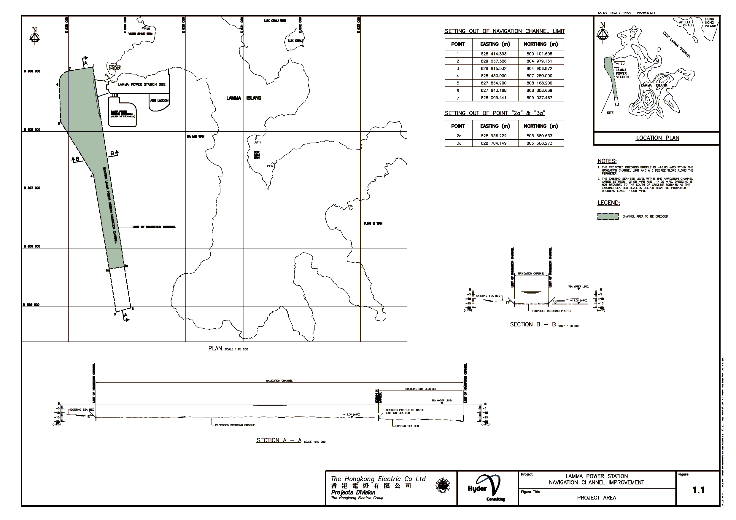
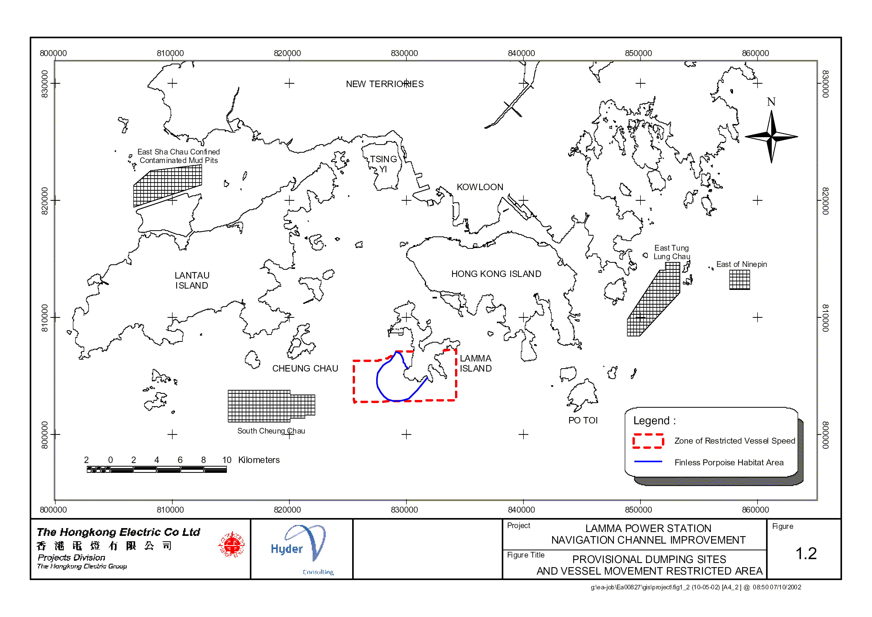
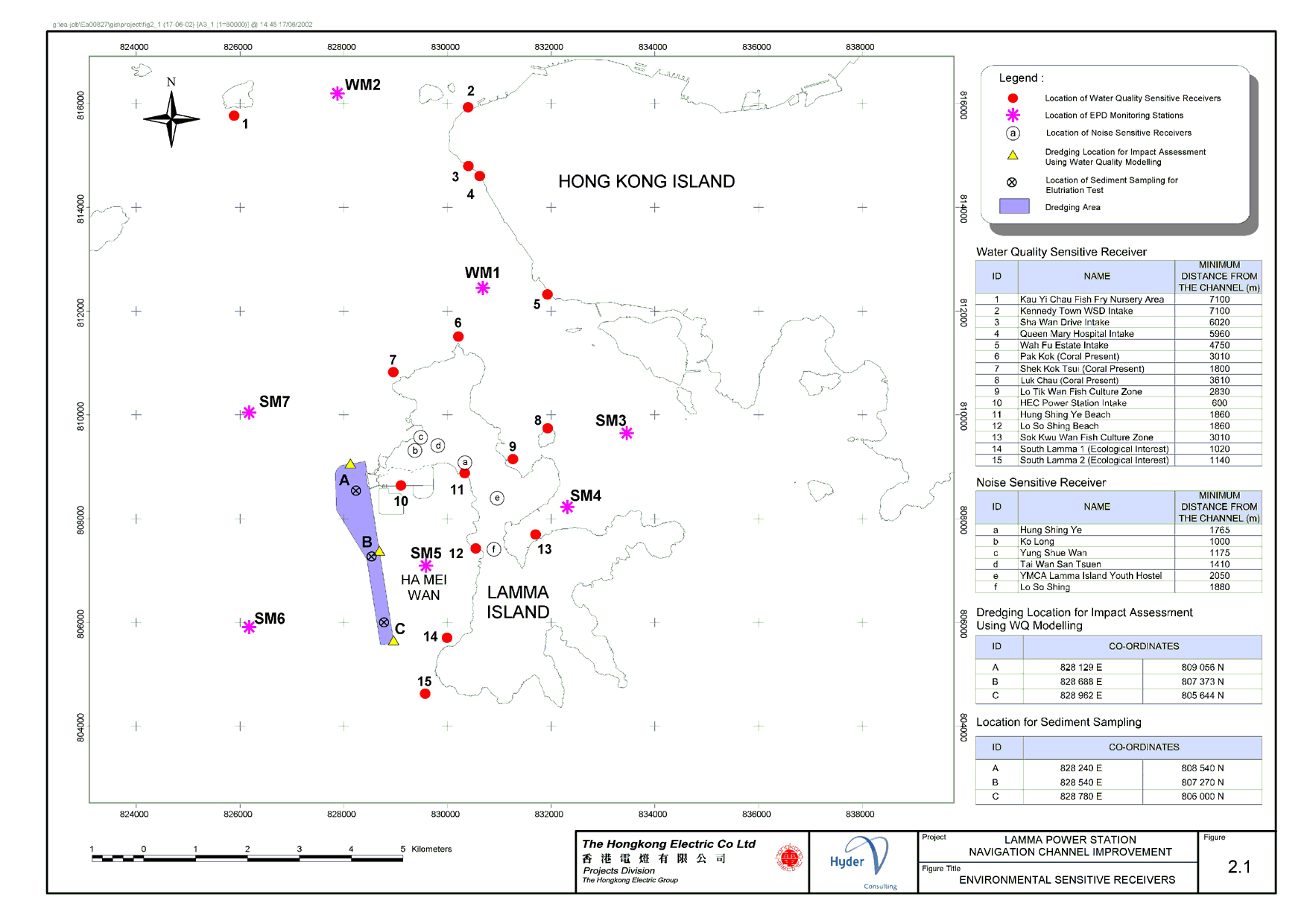
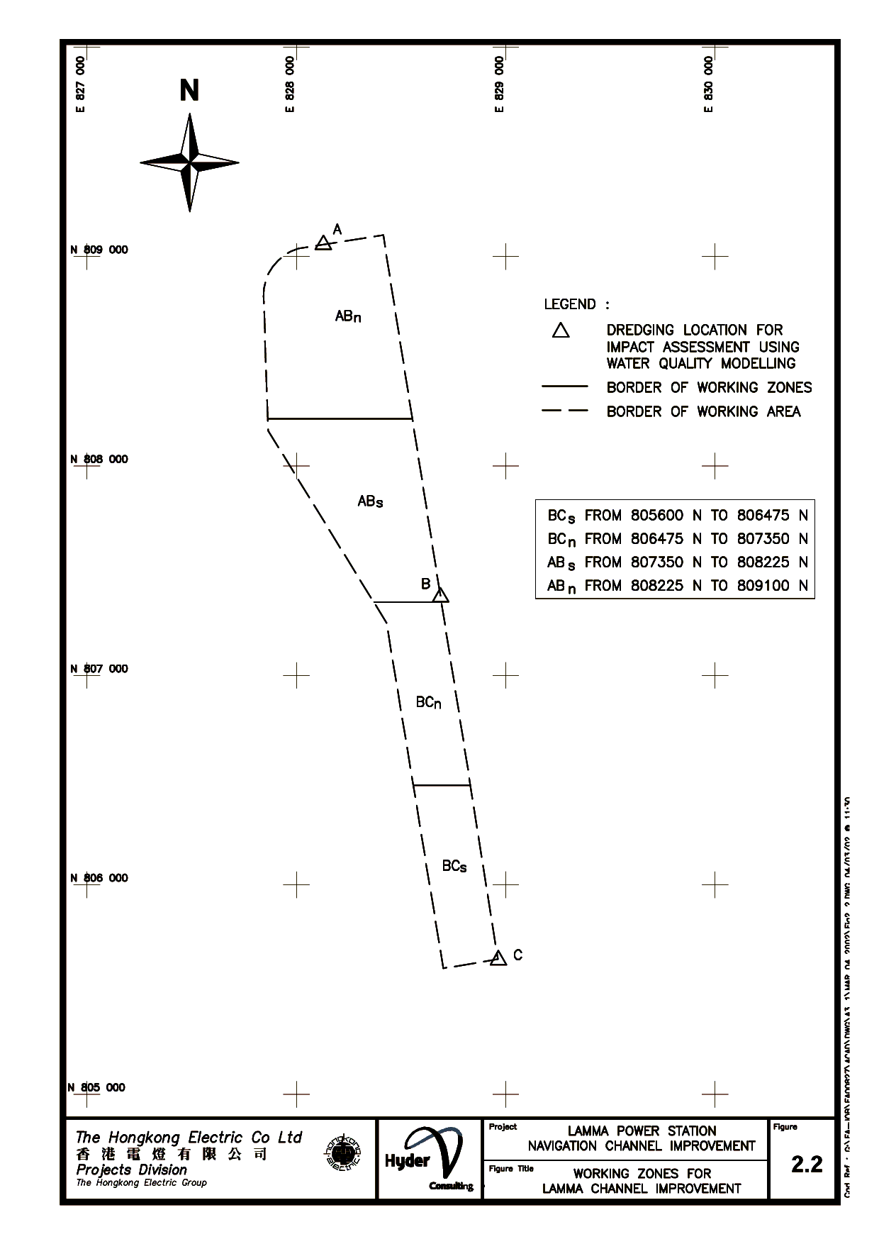
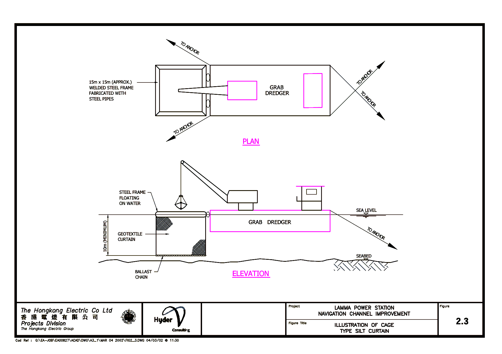
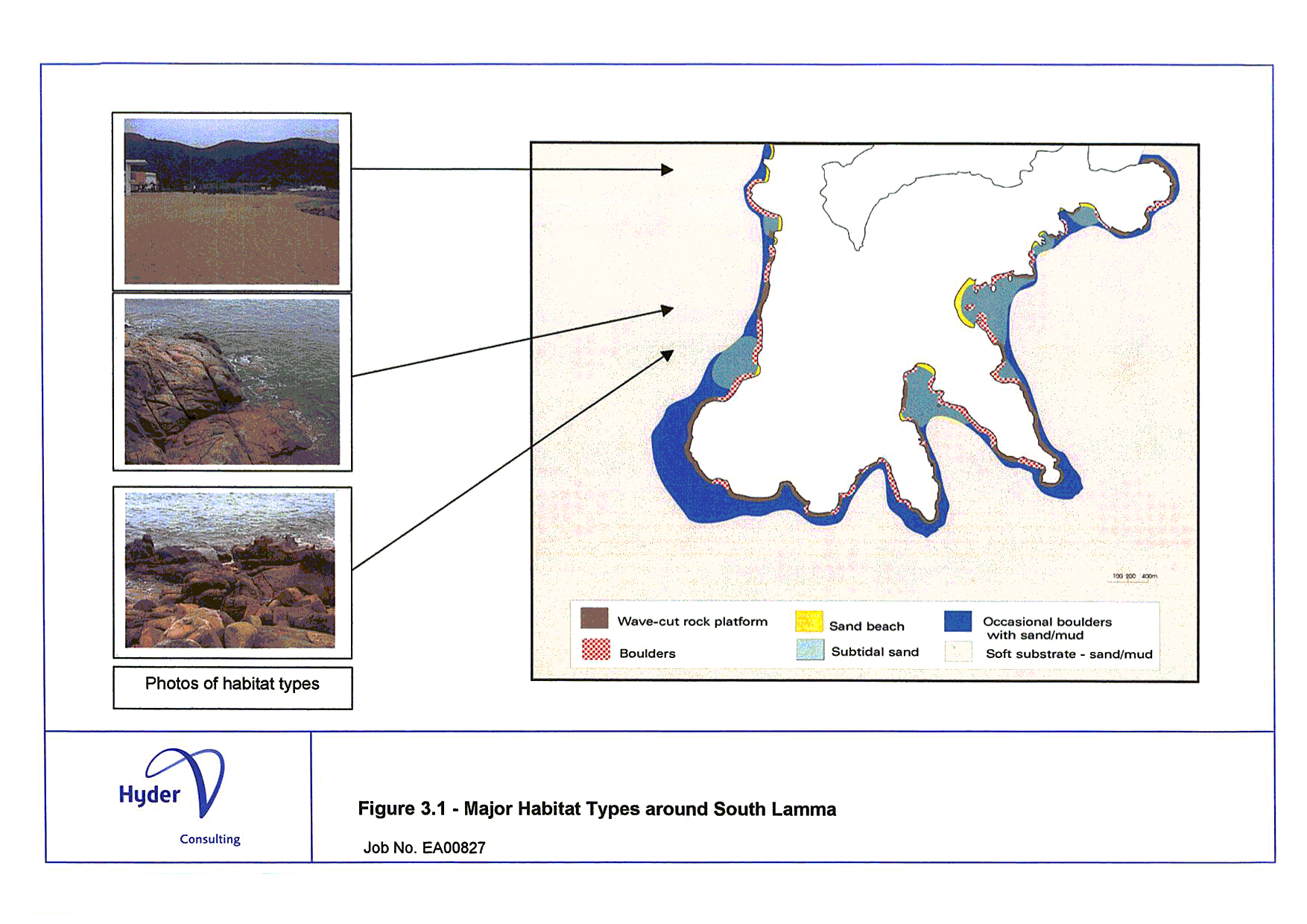
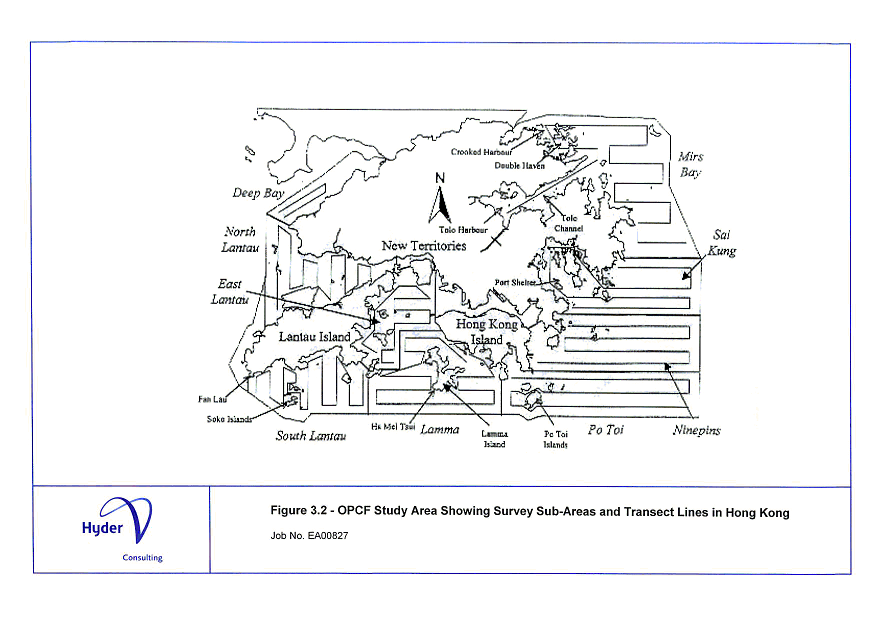
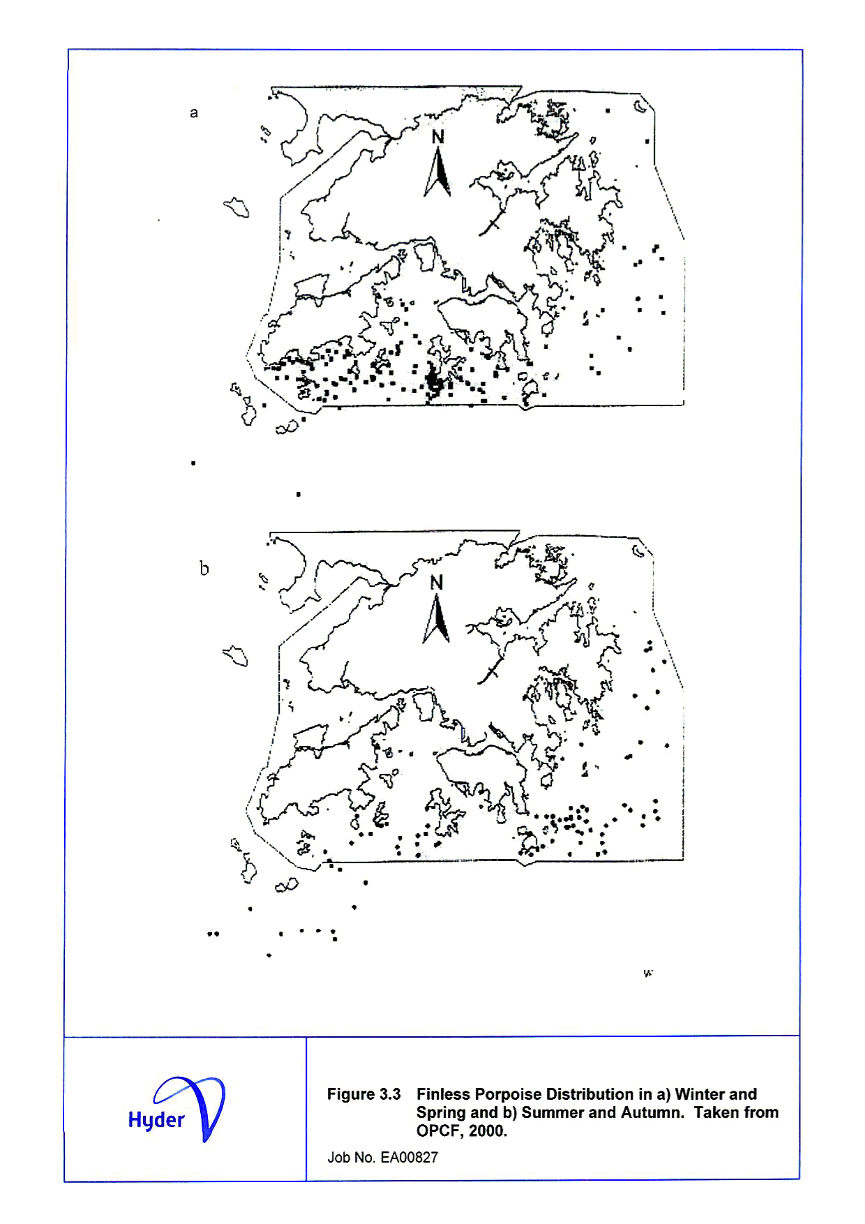
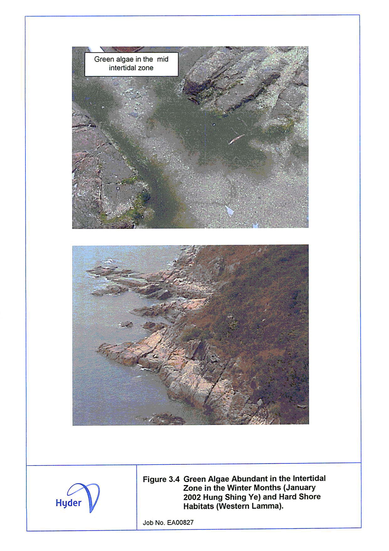
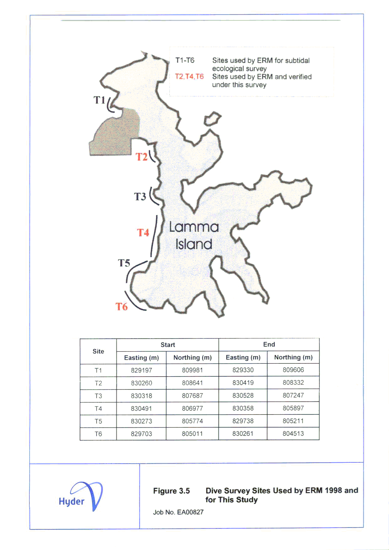
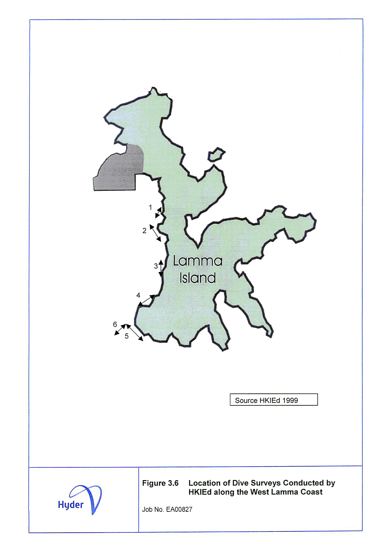
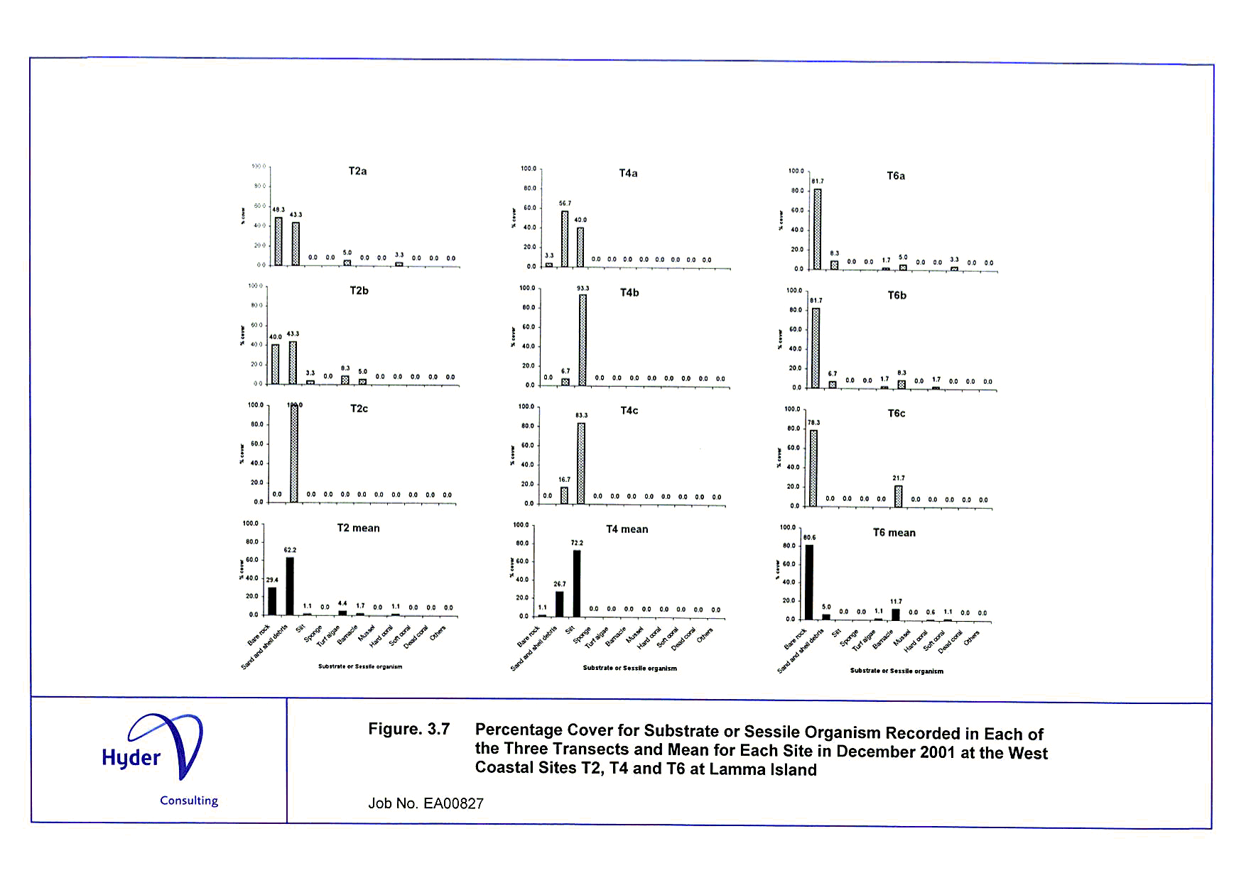
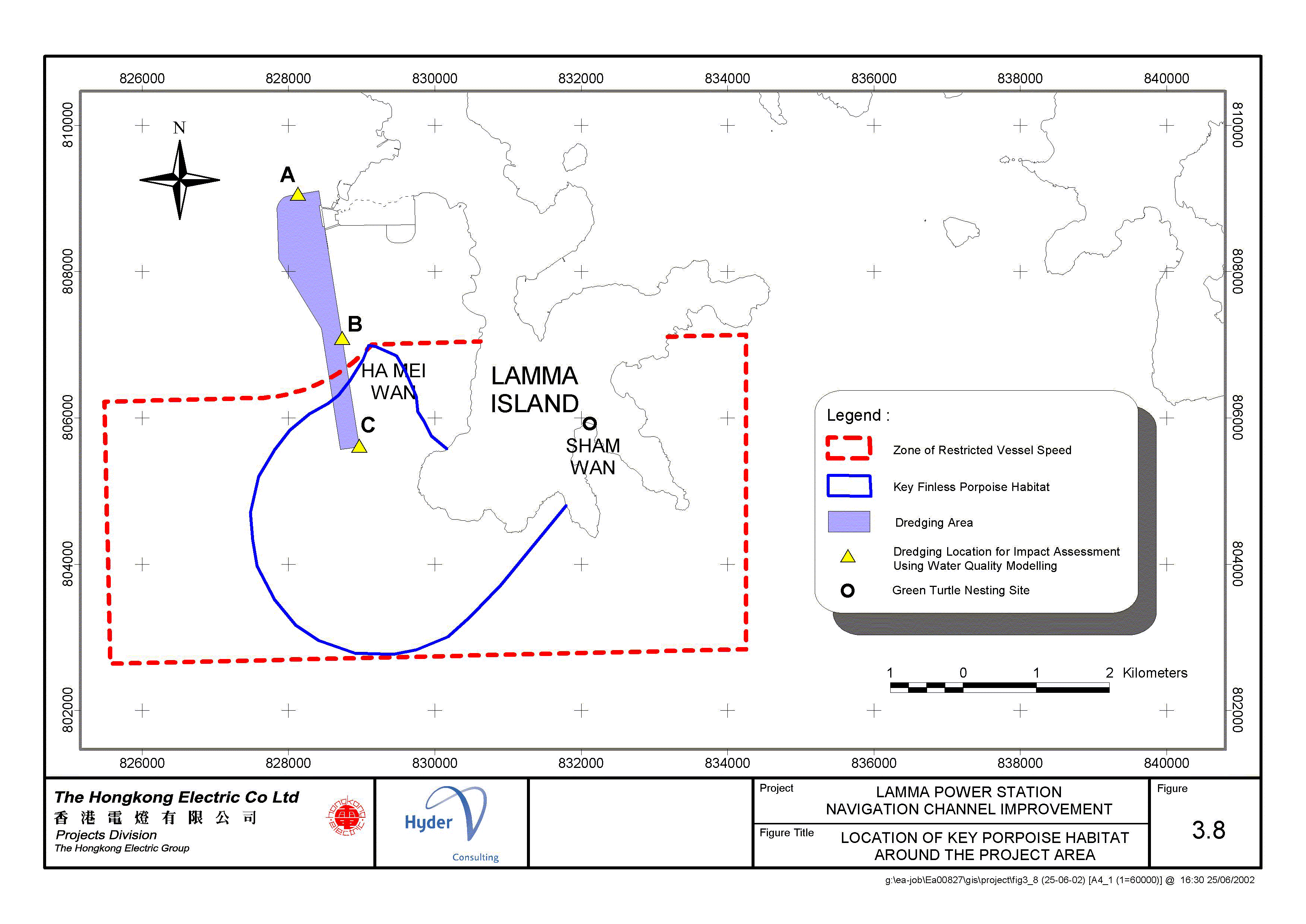
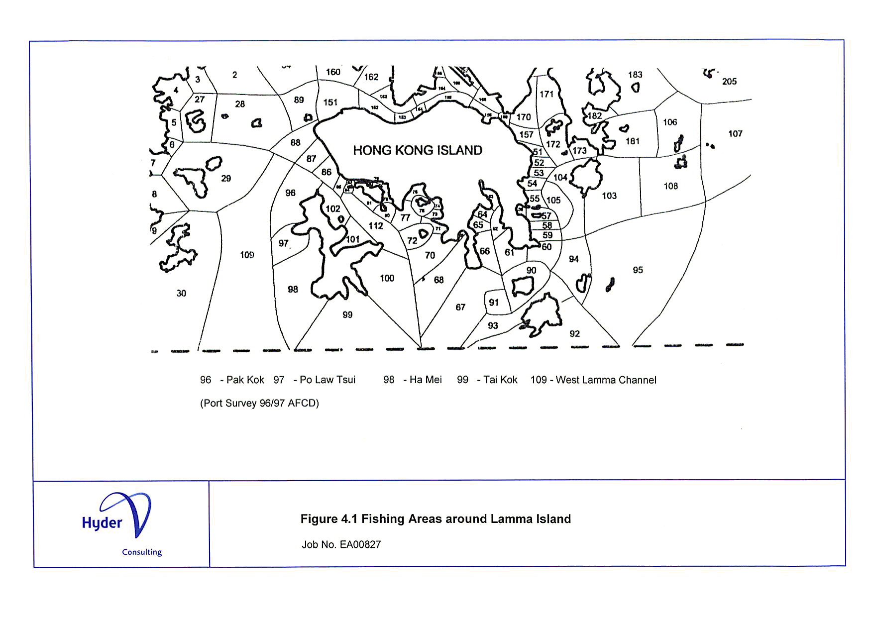
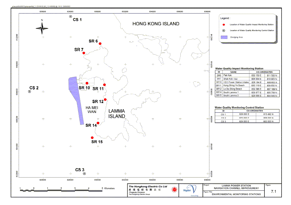
\Figures\EIA\GIF\Fig%203-8.gif)