5.1.1
This section presents the
assessment results of the potential water quality impact associated with the
proposed Wan Chai sewage submarine outfall (DP5). Mitigation measures are also recommended
to minimise potential adverse impacts and to ensure the acceptability of any
residual impact (that is, after mitigation). It should be highlighted that no
secondary contact recreation zones and water sports activities will be proposed
for the coastal water within the Project site boundary.
5.2.1
In order to evaluate the
potential water quality impacts from the Project, water sensitive receivers
(WSR) in Victoria
Harbour and its adjacent
waters were considered. Major water
sensitive receivers identified include:
·
WSD Flushing Water Intakes;
·
Cooling
Water Intakes; and
·
Corals.
5.2.2
Water sensitive receivers
identified outside the Project site boundary in farther field within Victoria Harbour and its adjacent waters are
shown in Figure 5.1. No sensitive coral sites were identified
in the Victoria Harbour. The Green
Island and Junk Bay
coral communities are located more than 5.5 km west and 6.5 km east
of the proposed work site, respectively.
These ecological sensitive receivers are included for water quality
assessment as they are potentially affected during the construction phase of
the Project due to the sedimentation of suspended solids in the water column.
Potential adverse impacts on the coral communities, in terms of sedimentation
rate, are addressed in Section 5.7.
Further discussions are included in the marine ecological impact
assessment (Section 9).
5.2.3
A number of cooling water
pumping stations and intakes are located within the proposed WDII permanent
reclamation limit along the existing waterfront of Wan Chai. These intakes
supply cooling water to the air conditioning systems of various commercial
buildings in the Wan Chai area including:
·
Hong Kong Convention and Exhibition Centre (HKCEC) Phase 1
·
Shui
On Centre
·
Telecom House
·
Government Buildings (Wan Chai
Tower/Revenue Tower/Immigration Tower)
·
China Resources
Building
·
Hong Kong
Exhibition Centre
·
Great
Eagle Centre
·
Sun
Hung Kai Centre.
5.2.4
Cooling water intake for Sun
Hung Kai Centre will be reprovisioned to the new waterfront of Wan Chai during
operational phase of the Project. The rest of the above listed cooling water
intakes will be reprovisioned to the intake chambers to the north of HKCEC
Extension.
5.2.5
An existing WSD flushing water
intake is also located within the proposed WDII reclamation limit at Wan Chai
which will be uprated and reprovisioned to Wan Shing Street under this Project.
5.2.6
Figure 5.2 shows the locations of the existing and reprovisioned seawater
intakes within the Project site boundary.
Cooling water intakes for some potential future developments are also
included in Figure 5.2 for
reference. Further description of
these cooling water intakes are provided in Section 5.6.
5.2.7
It should be noted that
the MTRC South Intake previously situated at the Wan Chai waterfront between
Central Reclamation Phase III (CRIII) and HKCEC Extension has been relocated to
the Central waterfront as shown in Figure 5.1.
5.3.1
The criteria for evaluating
water quality impacts in this EIA Study include:
Environmental Impact Assessment Ordinance (EIAO)
5.3.2
The Technical Memorandum on
Environmental Impact Assessment Process (Environmental Impact Assessment
Ordinance) (EIAO-TM) was issued by EPD under Section 16 of the EIAO. It specifies the assessment method and
criteria that were followed in this Study.
Reference sections in the EIAO-TM provide the details of assessment
criteria and guidelines that are relevant to the water quality assessment,
including:
·
Annex 6 – Criteria for Evaluating Water Pollution
·
Annex 14 – Guidelines for Assessment of Water
Pollution.
Water Quality Objectives
5.3.3
The Water Pollution Control
Ordinance (WPCO) provides the major statutory framework for the protection and
control of water quality in Hong Kong. According to the Ordinance and its
subsidiary legislation, Hong Kong waters are
divided into ten Water Control Zones (WCZs). Corresponding statements of Water
Quality Objectives (WQO) are stipulated for different water regimes (marine
waters, inland waters, bathing beaches subzones, secondary contact recreation
subzones and fish culture subzones) in the WCZ based on their beneficial
uses. The proposed Project is
located within Victoria
Harbour (Phase Three) WCZ
and the corresponding WQO are listed in Table 5.1.
Table 5.1 Summary
of Water Quality Objectives for Victoria
Harbour WCZ
|
Parameters
|
Objectives
|
Sub-Zone
|
|
Offensive odour, tints
|
Not to be present
|
Whole zone
|
|
Visible foam, oil scum,
litter
|
Not to be present
|
Whole zone
|
|
Dissolved oxygen (DO)
within 2 m of the seabed
|
Not less than 2.0 mg/l for
90% of samples
|
Marine waters
|
|
Depth-averaged DO
|
Not less than 4.0 mg/l for
90% of samples
|
Marine waters
|
|
pH
|
To be in the range of 6.5 -
8.5, change due to human activity not to exceed 0.2
|
Marine waters
|
|
Salinity
|
Change due to human
activity not to exceed 10% of ambient
|
Whole zone
|
|
Temperature
|
Change due to human
activity not to exceed 2 oC
|
Whole zone
|
|
Suspended solids (SS)
|
Not to raise the ambient
level by 30% caused by human activity
|
Marine waters
|
|
Unionised ammonia (UIA)
|
Annual mean not to exceed
0.021 mg/l as unionised form
|
Whole zone
|
|
Nutrients
|
Shall not cause excessive
algal growth
|
Marine waters
|
|
Total inorganic nitrogen
(TIN)
|
Annual mean depth-averaged
inorganic nitrogen not to exceed 0.4 mg/l
|
Marine waters
|
|
Toxic substances
|
Should not attain such
levels as to produce significant toxic, carcinogenic, mutagenic or teratogenic
effects in humans, fish or any other aquatic organisms.
|
Whole zone
|
|
Human activity should not
cause a risk to any beneficial use of the aquatic environment.
|
Whole zone
|
Source: Statement
of Water Quality Objectives (Victoria
Harbour (Phases One, Two
and Three) Water Control Zone).
Water Supplies Department (WSD) Water Quality
Criteria
5.3.4
Besides the WQO set under the
WPCO, the WSD has specified a set of objectives for water quality at flushing
water intakes as listed in Table 5.2
which shall not be exceeded at all stages of the Project.. The target limit for suspended solids
(SS) at these intakes is 10 mg/l or less.
Table 5.2 WSD’s
Water Quality Criteria for Flushing Water at Sea Water Intakes
|
Parameter (in
mg/l unless otherwise stated)
|
Target Limit
|
|
Colour (HU)
|
< 20
|
|
Turbidity (NTU)
|
< 10
|
|
Threshold Odour
Number (odour unit)
|
< 100
|
|
Ammoniacal
Nitrogen
|
< 1
|
|
Suspended
Solids
|
< 10
|
|
Dissolved
Oxygen
|
> 2
|
|
Biochemical
Oxygen Demand
|
< 10
|
|
Synthetic
Detergents
|
< 5
|
|
E. coli (no. per 100
mL)
|
< 20,000
|
Cooling Water Intake Standards
5.3.5
Based on a questionnaire survey
conducted under the approved Comprehensive Feasibility Study for Wan Chai
Development Phase II (WDIICFS) EIA (),
a SS limit of 40 mg/L was adopted as the assessment criterion for
Admiralty Centre intake and MTRC South intake. No information on the SS limit is
available for other cooling water intakes. These findings have been confirmed
by a telephone survey conducted under the recent approved EIA for the Hong Kong
Convention and Exhibition Centre (HKCEC) Atrium Link Extension (ALE). The locations of the cooling water
intakes are shown in Figure 5.1 and Figure 5.2. The SS criterion for
cooling water intakes is different from that for the WSD’s intakes as their
beneficial uses are different (the former is used for cooling water system and
the latter for flushing purpose).
Technical Memorandum
5.3.6
Discharges of effluents are
subject to control under the WPCO. The Technical Memorandum on Standards for
Effluents Discharged into Drainage and Sewerage Systems, Inland and Coastal
Waters (TM-DSS) gives guidance on the permissible effluent discharges based on
the type of receiving waters (foul sewers, storm water drains, inland and
coastal waters). The limits control
the physical, chemical and microbial quality of effluents. Any sewage from the
proposed construction and operation activities must comply with the standards
for effluents discharged into the foul sewers, inshore waters or marine waters
of Victoria Harbour WCZ, as given in the TM-DSS.
Practice Note
5.3.7
A Practice Note for
Professional Persons (ProPECC) was issued by the EPD to provide guidelines for
handling and disposal of construction site discharges. The ProPECC PN 1/94 “Construction Site
Drainage” provides good practice guidelines for dealing with ten types of
discharge from a construction site.
These include surface runoff, groundwater, boring and drilling water,
bentonite slurry, water for testing and sterilisation of water retaining
structures and water pipes, wastewater from building constructions, acid
cleaning, etching and pickling wastewater, and wastewater from site
facilities. Practices given in the
ProPECC PN 1/94 should be followed as far as possible during construction to
minimise the water quality impact due to construction site drainage.
Assessment Criteria for Corals
5.3.8
Potential impacts on benthic
organisms, including corals, may arise through excessive sediment
deposition. The magnitude of
impacts on marine ecological sensitive receivers was assessed based on the
predicted elevation of SS and sedimentation rate.
5.3.9
According
to the WQO criteria, elevation of SS less than 30% of ambient level, which is
set for among other reasons, to offer protection for marine ecological
resources, is adopted in this assessment for coral protection. This criterion
is more stringent than that previously adopted in other EIA study for assessing
SS impact on hard corals in eastern Hong Kong
waters (i.e. SS elevation less than 10 mg/L, ERM 2003 ()).
5.3.10
According
to Pastorok and Bilyard ()
and Hawker and Connell (),
a sedimentation rate higher than 0.1
kg/m2/day would introduce moderate to severe impact
upon corals. This criterion has
been adopted for protecting the corals in Hong Kong under other approved EIAs
such as Tai Po Sewage Treatment Works Stage 5 EIA ([5]),
Further Development of Tseung Kwan O Feasibility Study EIA, Wan Chai
Reclamation Phase II EIA, Eastern Waters MBA Study (),
West Po Toi MBA Study ()
and Tai Po Gas Pipeline Study (). This sedimentation rate criterion is considered
to offer sufficient protection to marine ecological sensitive receivers and is
anticipated to guard against unacceptable impacts. This protection has been confirmed by
previous EM&A results which have indicated no adverse impacts to corals
have occurred when this assessment criterion has been adopted.
5.3.11
The
assessment criteria used in this Project for protection of corals identified at
Green Island,
Junk Bay
and Cape Collinson is also based on the WQO for
SS established under the WPCO, i.e. the SS elevations should be less than 30%
of ambient baseline conditions. The
WQO for SS has also been adopted under the approved Tai Po Sewage Treatment
Works Stage 5 EIA as one of the assessment criteria for evaluating the water
quality impact from the sewage effluent on corals identified at Tolo Harbour,
Green Island
and Junk Bay.
5.3.12
The
above assessment criteria would be used to assess water quality impact to coral
habitats (i.e. the far field ecological sensitive receivers) as identified and
indicated in Figure 5.1.
5.4
Description of
the Environment
Marine Water Quality in Victoria Harbour
5.4.1
The marine water quality
monitoring data routinely collected by EPD in Victoria Harbour
were used to establish the baseline condition. A summary of water quality data
for selected EPD monitoring stations extracted from the EPD’s publication “20
years of Marine Water Quality Monitoring in Hong Kong” (which is the latest
version available at the time of preparing this report) is presented in Table 5.3 for Victoria Harbour WCZ (VM1
VM2, VM4-VM8, VM12 and VM15).
Locations of the monitoring stations are shown in Figure 5.1.
5.4.2
In the past, wastewater from
both sides of the Victoria Harbour was discharged into it after just simple
screening, leading to marine water low in DO and high in organic nutrients and
sewage bacteria. Commissioning
of HATS Stage 1 in
late 2001 has brought large and sustained improvements to the water quality of
the eastern and central Victoria
Harbour. However,
improvements are less noticeable in the western harbour area which was still
subject to the sewage discharges from local PTW (Central, Wan Chai West and Wan
Chai East).As the HATS Stage 1 was commissioned in late 2001, the data for 2005
as shown in Table 5.3 represent the
situation after the commissioning of HATS Stage 1.
5.4.3
In 2005, the marked
improvements in eastern Victoria
Harbour (VM1 and VM2) and
moderate improvements in the mid harbour area (VM4 and VM5) and northern part
of Rambler Channel (VM14) since HATS Stage 1 was commissioned were generally
sustained. Several monitoring
stations in the WCZ are located close to sewage outfalls, including VM5 (Wan
Chai East and Wan Chai West PTW outfall), VM6 (Central PTW
outfall), VM4 (North Point PTW outfall) and VM8 (SCISTW – HATS Stage 1
outfall). The water quality at
these stations was inevitably subject to the direct impact of sewage discharge
from these outfalls. The WQO
compliance in 2005 was 83%, slightly lower than that in 2004 (87%). Full compliance with the WQO (for DO and
UIA) was achieved in 2005 in
the Victoria Harbour WCZ. However,
the WQO compliance for TIN was only 50% in 2005.
Table 5.3 Summary
Statistics of 2005 Marine Water Quality in Victoria Harbour
|
Parameter
|
Victoria Harbour East
|
Victoria Harbour
Central
|
Victoria
Harbour West
|
Stonecutters
Island
|
Rambler Channel
|
WPCO WQO (in marine waters)
|
|
VM1
|
VM2
|
VM4
|
VM5
|
VM6
|
VM7
|
VM8
|
VM15
|
VM12
|
VM14
|
|
Temperature (oC)
|
22.6
(15.7-27.9)
|
22.9
(15.8-28.0)
|
22.9
(15.8-27.8)
|
23
(15.9-27.9)
|
23
(15.9-27.8)
|
23.1
(15.8-27.9)
|
23.1
(15.6-27.7)
|
23
(16.0-27.8)
|
23.1
(15.8-27.7)
|
23.4
(15.9-27.9)
|
Not more than 2 oC in daily
temperature range
|
|
Salinity
|
32.3
(30.4-33.4)
|
31.9
(28.5-33.3)
|
31.8(28.9-33.2)
|
31.4
(27.3-32.9)
|
31.3
(26.8-32.8)
|
30.9
(26.3-32.8)
|
31.1
(27.4-32.9)
|
31.3
(26.6-32.9)
|
31(27.7-33.0)
|
29.6
(23.0-33.0)
|
Not to cause more than 10% change
|
|
Dissolved Oxygen (DO) (% Saturation)
|
Depth average
|
79
(59-94)
|
78
(66-92)
|
75
(63-88)
|
76
(68-99)
|
77
(68-96)
|
78
(72-99)
|
80
(61-108)
|
77
(64-105)
|
75
(54-94)
|
80
(68-105)
|
Not available
|
|
Bottom
|
78
(46-93)
|
77
(54-90)
|
74
(51-88)
|
74
(46-99)
|
73
(45-94)
|
75
(54-94)
|
78
(35-108)
|
74
(43-101)
|
74
(42-92)
|
79
(52-103)
|
Not available
|
|
Dissolved Oxygen (DO)
(mg/l)
|
Depth average
|
5.7
(4.2-6.9)
|
5.6
(4.4-6.8)
|
5.4
(4.4-6.6)
|
5.5
(4.7-6.6)
|
5.5
(4.8-6.5)
|
5.6
(4.9-6.6)
|
5.8
(4.3-7.1)
|
5.5
(4.5-7.0)
|
5.4
(3.8-6.4)
|
5.7
(4.8-6.9)
|
Not less than 4 mg/l for 90% of the samples
|
|
Bottom
|
5.6
(3.3-6.9)
|
5.6
(3.8-6.8)
|
5.3
(3.6-6.5)
|
5.3
(3.3-6.6)
|
5.3
(3.2-6.5)
|
5.4
(3.8-6.5)
|
5.6
(2.5-7.1)
|
5.3
(3.1-6.7)
|
5.3
(2.9-6.2)
|
5.6
(3.7-6.9)
|
Not less than 2 mg/l for 90% of the samples
|
|
pH
|
8.1
(7.8-8.3)
|
8.1
(7.7-8.3)
|
8
(7.7-8.3)
|
8
(7.6-8.3)
|
8
(7.6-8.2)
|
8
(7.7-8.2)
|
8.1
(7.7-8.2)
|
8
(7.6-8.2)
|
8
(7.7-8.2)
|
8.1
(7.7-8.2)
|
6.5 - 8.5 (± 0.2 from natural range)
|
|
Secchi disc
Depth (m)
|
2.3
(1.5-2.8)
|
2.2
(1.2-3.5)
|
2.1
(1.5-3.2)
|
2.1
(1.3-3.1)
|
2.1
(1.2-3.3)
|
1.8
(0.9-3.2)
|
1.9
(1.2-2.5)
|
1.9
(1.2-2.7)
|
1.7
(1.2-2.5)
|
1.8
(1.5-2.3)
|
Not available
|
|
Turbidity (NTU)
|
10
(5.1-16.2)
|
9.8
(4.8-15.8)
|
9.6
(4.5-15.3)
|
9.8
(4.9-14.5)
|
9.8
(5.0-14.8)
|
10.8(5.9-16.1)
|
11.9
(5.4-22.0)
|
10.7
(5.8-16.2)
|
14.4
(6.4-22.1)
|
11.3
(5.4-17.1)
|
Not available
|
|
Suspended Solids (SS) (mg/l)
|
4.5
(0.9-10.8)
|
3.6
(1.3-8.5)
|
3.6
(1.3-9.8)
|
3.4
(1.7-5.3)
|
3.7
(1.3-8.2)
|
4.1
(2.1-8.7)
|
5.2
(1.8-16.3)
|
5.1
(2.1-10.3)
|
7.2
(3.1-15.7)
|
4.7
(2.6-10.7)
|
Not more than 30% increase
|
|
5-day Biochemical Oxygen Demand (BOD5)
(mg/l)
|
0.8
(0.5-1.2)
|
0.9
(0.4-1.5)
|
0.9
(0.5-1.1)
|
1.1
(0.6-1.4)
|
0.9
(0.4-1.4)
|
1
(0.6-1.4)
|
0.8
(0.5-1.4)
|
0.8
(0.5-1.2)
|
0.7
(0.4-1.2)
|
0.8
(0.4-1.6)
|
Not available
|
|
Nitrite Nitrogen (NO2-N) (mg/l)
|
0.02
(0.01-0.05)
|
0.02
(0.01-0.05)
|
0.03
(0.01-0.05)
|
0.03
(0.01-0.05)
|
0.03
(0.01-0.05)
|
0.03
(0.01-0.06)
|
0.04
(0.01-0.07)
|
0.03
(0.02-0.06)
|
0.04
(0.02-0.07)
|
0.05
(0.01-0.09)
|
Not available
|
|
Nitrate Nitrogen (NO3-N) (mg/l)
|
0.1
(0.04-0.17)
|
0.12
(0.03-0.23)
|
0.13
(0.05-0.24)
|
0.15
(0.05-0.31)
|
0.16
(0.06-0.34)
|
0.19
(0.08-0.45)
|
0.18
(0.08-0.49)
|
0.16
(0.09-0.31)
|
0.2
(0.09-0.45)
|
0.27
(0.09-0.67)
|
Not available
|
|
Ammonia Nitrogen (NH3-N) (mg/l)
|
0.09
(0.05-0.16)
|
0.13
(0.04-0.21)
|
0.15
(0.06-0.27)
|
0.19
(0.06-0.29)
|
0.19
(0.07-0.26)
|
0.21
(0.12-0.32)
|
0.18
(0.09-0.30)
|
0.23
(0.08-0.32)
|
0.2
(0.14-0.25)
|
0.17
(0.10-0.25)
|
Not available
|
|
Unionised
Ammonia (UIA) (mg/l)
|
0.004
(0.002-0.010)
|
0.006
(0.002-0.015)
|
0.006
(0.003-0.015)
|
0.007
(0.005-0.015)
|
0.008
(0.004-0.014)
|
0.009
(0.004-0.018)
|
0.009
(0.003-0.022)
|
0.009
(0.005-0.014)
|
0.008
(0.005-0.012)
|
0.008
(0.004-0.013)
|
Not more than 0.021 mg/l for annual mean
|
|
Total Inorganic Nitrogen (TIN) (mg/l)
|
0.22
(0.11-0.32)
|
0.28
(0.08-0.46)
|
0.31
(0.12-0.54)
|
0.37
(0.12-0.64)
|
0.38
(0.14-0.65)
|
0.43
(0.28-0.83)
|
0.4
(0.22-0.76)
|
0.42
(0.19-0.63)
|
0.44
(0.31-0.71)
|
0.49
(0.29-0.91)
|
Not more than 0.4 mg/l for annual mean
|
|
Total Nitrogen (TN) (mg/l)
|
0.34
(0.23-0.47)
|
0.43
(0.22-0.63)
|
0.47
(0.26-0.69)
|
0.55
(0.28-0.77)
|
0.55
(0.29-0.79)
|
0.58
(0.47-0.93)
|
0.59
(0.34-1.16)
|
0.58
(0.36-0.76)
|
0.63
(0.43-1.31)
|
0.66
(0.40-1.02)
|
Not available
|
|
Orthophosphate Phosphorus (PO4)
(mg/l)
|
0.02
(0.01-0.03)
|
0.03
(<0.01-0.04)
|
0.03
(0.01-0.04)
|
0.04
(0.01-0.05)
|
0.03
(0.01-0.05)
|
0.04
(0.02-0.05)
|
0.03
(0.01-0.05)
|
0.04
(0.02-0.05)
|
0.03
(0.02-0.04)
|
0.03
(0.02-0.04)
|
Not available
|
|
Total Phosphorus (TP) (mg/l)
|
0.03
(0.02-0.05)
|
0.04
(0.02-0.06)
|
0.05
(0.03-0.06)
|
0.05
(0.03-0.07)
|
0.05
(0.03-0.07)
|
0.05
(0.04-0.06)
|
0.05
(0.03-0.17)
|
0.05
(0.03-0.07)
|
0.06
(0.04-0.17)
|
0.05
(0.03-0.11)
|
Not available
|
|
Chlorophyll-a
(µg/L)
|
2.5
(0.9-6.0)
|
2.4
(0.8-6.0)
|
2.4
(0.9-7.2)
|
2.8
(0.8-9.1)
|
2.6
(0.8-9.0)
|
2.2
(0.8-7.6)
|
2
(0.9-6.4)
|
3.2
(0.7-12.3)
|
1.8
(0.9-4.8)
|
2.8
(0.8-11.8)
|
Not available
|
|
E
coli
(cfu/100 ml)
|
640
(88-4500)
|
1600
(120-31000)
|
2400
(310-11000)
|
7700
(2500-23000)
|
5700
(1200-33000)
|
9100
(1200-35000)
|
4900
(790-40000)
|
5400
(490-22000)
|
4000
(1200-17000)
|
2100
(520-8700)
|
Not available
|
|
Faecal Coliforms
(cfu/100 ml)
|
1300
(300-9100)
|
3600
(340-50000)
|
5200
(770-33000)
|
17000
(6800-40000)
|
12000
(2300-89000)
|
21000
(2700-130000)
|
12000
(1500-140000)
|
13000
(1800-97000)
|
9700
(2600-35000)
|
4700
(1500-31000)
|
Not available
|
Notes: 1.
Except as specified, data presented are depth-averaged values calculated by
taking the means of three depths: Surface, mid-depth, bottom.
2. Data presented are annual arithmetic means of
depth-averaged results except for E. coli
and faecal coliforms that are annual geometric means.
3. Data in brackets indicate the ranges.
Marine Water Quality within Causeway Bay
Typhoon Shelter (CBTS)
5.4.4
A summary of published EPD
monitoring data (in 2005) collected from the monitoring station at the CBTS
(VT2) is presented in Table 5.4.
The data are extracted from the EPD’s publication “20 years of Marine Water
Quality Monitoring in Hong Kong”.
Table 5.4 Summary
Statistics of 2005 Marine Water Quality at the Causeway Bay
Typhoon Shelter
|
Parameter
|
EPD
Monitoring Station (Bi-Monthly)
|
WPCO WQOs (in marine waters)
|
|
|
|
Temperature (oC)
|
22.8
(15.9 – 27.3)
|
Not more than 2 oC
in daily temperature range
|
|
Salinity (ppt)
|
30.2
(25.2 – 32.2)
|
Not to cause more than 10%
change
|
|
Dissolved Oxygen (DO)
(% saturation)
|
Depth average
|
68
(53 – 103)
|
Not available
|
|
Bottom
|
68
(53 – 102)
|
Not available
|
|
DO (mg/l)
|
Depth average
|
4.9
(3.6 – 7.2)
|
Not less than 4 mg/L for
90% of the samples
|
|
|
Bottom
|
4.9
(3.6 – 7.1)
|
Not less than 2 mg/L for
90% of the samples
|
|
pH value
|
8.1
(7.9 – 8.3)
|
6.5 - 8.5 (± 0.2 from natural range)
|
|
Secchi disc (m)
|
1.9
(1.5 – 2.9)
|
Not available
|
|
Turbidity (NTU)
|
8.8
(5.0 – 9.9)
|
Not available
|
|
Suspended Solids (SS) (mg/l)
|
5.8
(3.0 – 13.8)
|
Not more than 30%
increase
|
|
Silica (as SiO2)(mg/l)
|
1.0
(0.5 – 1.4)
|
Not available
|
|
5-day Biochemical
Oxygen Demand (BOD5) (mg/l)
|
1.6
(1.2 – 2.9)
|
Not available
|
|
Nitrite
Nitrogen (NO2-N) (mg/l)
|
0.04
(0.02 – 0.05)
|
Not available
|
|
Nitrate Nitrogen (NO3-N)
(mg/l)
|
0.19
(0.11 – 0.32)
|
Not available
|
|
Ammoniacal Nitrogen (NH3-N)
(mg/l)
|
0.20
(0.18 – 0.30)
|
Not available
|
|
Unionised Ammonia
(UIA)
(mg/l)
|
0.011
(0.005 – 0.021)
|
Not more than 0.021 mg/L
for annual mean
|
|
Total Inorganic Nitrogen (TIN) (mg/l)
|
0.43
(0.35 – 0.55)
|
Not more than 0.4 mg/L
for annual mean
|
|
Total Nitrogen (TN)
(mg/l)
|
0.65
(0.56 – 0.80)
|
Not available
|
|
Ortho-Phosphate (OrthoP) (mg/l)
|
0.04
(0.02 – 0.05)
|
Not available
|
|
Total Phosphorus (TP)
(mg/l)
|
0.06
(0.05 – 0.08)
|
Not available
|
|
Chlorophyll-a
(µg L-1)
|
4.3
(0.5 – 16.5)
|
Not available
|
|
E. coli (cfu per 100 mL)
|
5,200
(2,300 – 12,000)
|
Not available
|
|
Faecal Coliform
(cfu per 100 mL)
|
17,000
(5,100 – 61,000)
|
Not available
|
Note: 1. Except
as specified, data presented are depth-averaged data.
2.
Data presented are annual arithmetic means except
for E. coli and faecal coliforms that
are geometric means.
3.
Data enclosed in brackets indicate ranges.
5.4.5
Due to the embayment form and
reduced flushing capacity of the typhoon shelter, marine water within the
typhoon shelter is vulnerable to pollution. In 2005, high levels of E.coli were recorded at the CBTS
indicating faecal contamination. The water quality level
marginally exceeded the WQO for TIN but fully complied with the WQO for DO and
UIA. Significant long-term improvements in terms of decreasing trends in TIN,
TN, OrthoP and TP were observed in CBTS.
Sediment Quality
5.4.6
The results of marine sediment
quality analysis from the marine ground investigation works at the Project site
are presented in Section 6. A
review of the sediment quality data from the marine ground investigation
indicated that the majority of marine sediments to be dredged at the Project
area were classified as contaminated. Details of the sediment quality criteria
and guidelines are given in Section 6.
Operational
Phase
5.5.1
During the operational phase,
the screened sewage currently discharged from the existing Wan Chai East (WCE)
and Wan Chai West (WCW) submarine outfalls would be diverted to the new WCE
submarine outfall to be constructed under the WDII. The locations of catchments
WCE and WCW are shown in Table A5-3-1
of Appendix 5.3. It is not expected that there would be
any adverse impacts on the overall water quality in the Victoria Harbour
due to such change in local distribution of sewage discharges. The associated water quality impact is
addressed in Section 5.7..
Construction Phase
5.5.2
Key water quality concerns
during the construction works are related to the dredging works will disturb the marine bottom sediment,
causing an increase in SS concentrations in the water column and forming
sediment plume along the tidal flows.
5.5.3
Potential impacts on water
quality from dredging will vary according to the quantities and level of
contamination, as well as the nature and locations of the WSR at or near the
dredging sites. These impacts are
summarised as follows:
·
Increased suspension of sediment in the water column
during dredging activities, with possible consequence of reducing DO levels and
increasing nutrient levels.
·
Release of previously bound organic and inorganic
constituents such as heavy metals, polynuclear aromatic hydrocarbons (PAHs),
polychlorinated biphenyls (PCBs) and nutrients into the water column, either
via suspension or by disturbance as a result of dredging activities, or
depositing of fill materials.
·
Release of the same contaminants due to leakage and
spillage as a result of poor handling and overflow from barges during dredging
and transport.
5.5.4
All of the above may result in
deterioration of the receiving marine water quality and may have adverse
effects on WSR. They are elaborated
in the following paragraphs.
Suspended Sediment
5.5.5
As a result of dredging and
filling activities during the construction phase, fine sediment (less than
63 µm) will be lost to suspension.
The suspended sediment will be transported by currents to form sediment
plumes, which will gradually resettle.
The impact from sediment plumes is to increase the suspended sediment
concentrations, and cause non-compliance in WQO and other criteria.
5.5.6
Any sediment plume will cause
the ambient suspended sediment concentrations to be elevated and the extent of
elevation will determine whether or not the impact is adverse or not. The determination of the acceptability
of any elevation is based on the WQO.
The WQO of SS is defined as being an allowable elevation of 30% above
the background. EPD maintains a
flexible approach to the definition of ambient levels, preferring to allow
definition on a case-by-case basis rather than designating a specific
statistical parameter as representing ambient. As adopted in the approved WDIICFS EIA
for assessing the environmental impacts of released SS, the ambient value is
represented by the 90th percentile of baseline (pre-construction)
concentrations.
Release of the Contaminants
due to Leakage and Spillage
5.5.7
Release of the same
contaminants due to leakage and spillage as a result of poor handling and
overflow from barges during dredging and transport can be addressed by proper
implementation of recommended mitigation measures in Section 5.8.
General Construction Activities
5.5.8
The general construction works
that will be undertaken for the Project may have the potential to cause water
pollution. These could result from
the accumulation of solid waste such as packaging and construction materials,
and liquid waste such as sewage effluent from the construction work force and
spillage of oil, diesel or solvents by vessels and vehicles involved with the
construction. If uncontrolled, any
of these could lead to deterioration in water quality. Increased nutrient levels result from
contaminated discharges and sewage effluent could also lead to a number of
secondary water quality impacts including decreases in DO concentrations and
localised increase in NH3-N concentrations which could stimulate
algal growth and reduction in oxygen levels.
5.5.9
Sewage will arise from sanitary
facilities provided for the on-site construction work force. It is characterised by high level of
BOD, NH3-N and E.coli
counts. For some of the works
areas, there will be no public sewers available for domestic sewage discharge
on-site.
5.6.1
To assess the potential water
quality impacts due to the construction and operation of the Project, the
sources and natures of water pollution to be generated during construction and
operation phases have been identified and their impacts are quantified where
practicable.
Sediment Plume Modelling
General Description of WDII reclamation
5.6.2
There
will be a total of five main reclamation areas under WDII, namely HKCEC, WCR,
NPR, TPCWA and TCBR respectively.
Each of these five reclamation areas is subdivided into different stages
for different engineering and environmental constraints as shown in Figure 2.7. Within the same reclamation area, seawall dredging will be performed in sequence instead of operating
concurrently. Thus,
dredging along the seawall will be undertaken for only one stage at a time to
minimize the potential water quality impacts. The
sequencing of the reclamation stages are presented in the construction
programme in Appendix 2.1.
5.6.3
Temporary
reclamation of Causeway Bay will be divided into four stages
(Figure 2.7).
Construction of TCBR1W and TCBR1E will be undertaken at the first stage with
seawall foundation to be constructed in sequence. Thus, dredging along the
seawall of TCBR1W will not be carried out simultaneously with the dredging
along the seawall of TCBR1E to minimize the dredging impact. At Stage 2,
dredging at seawall of TCBR2 will take place when TCBR1W and TCBR1E are in
place. Demolition of TCBR1E will
then proceed and the whole TCBR1E will be removed before the commencement of
TCBR3. Thus, during the third
stage, dredging for seawall foundation and seawall trench filling at TCBR3 will
take place when both TCBR1W and TCBR2 are in place at the same time. Subsequently, TCBR1W will be removed
before the TCBR4 commences. Therefore, water body behind temporary reclamation
area will not be fully enclosed, which minimise water quality impacts (also
refer to Figure 2.10 to Figure 2.14).
5.6.4
The proposed construction method
for permanent and temporary reclamation adopts an approach where permanent and
temporary seawalls will first be formed to enclose each phase of the
reclamation. Bulk filling will be carried out behind the completed seawall.
Demolition of temporary reclamation will involve excavation of bulk fills and
dredging to the existing seabed level which will be carried out behind the
temporary seawall. Temporary seawall will be removed after completion of all
excavation and dredging works for demolition of the temporary reclamation.
Therefore, the sediment plume can be effectively contained within the permanent
and temporary reclamation area.
Demolition of temporary seawall will involve removal of rock fill and
seawall blocks only, which would not create significant SS impact. Fines content in the filling materials
for seawall construction would be negligible and loss of fill material during
seawall construction is therefore not expected. Thus, potential water quality
impact of SS will only arise during the dredging for seawall foundation.
Modelling Scenario
5.6.5
The
construction of the proposed WCE submarine outfalls will require dredging along
the new outfall alignment. With
reference to the construction programme, dredging for construction of the
proposed WCE submarine outfall would be carried out in late 2009 to 2010
concurrently with the dredging at the Causeway Bay typhoon shelter (CBTS) for
construction of the CWB tunnel. One sediment plume modelling scenario, namely
Scenario 2B, is proposed to assess the dredging impacts. Scenario 2B assumes
that the following marine works will take place concurrently.
a.
Dredging
for seawall foundation for temporary reclamation in CBTS under Stage 1 West
(TCBR1W)
b.
Dredging along the proposed alignment of the
submarine sewage pipeline of the Wan Chai East Sewage Screening Plant.
5.6.6
This scenario is assumed to take place in late
2009 to 2010 where the seawall for HKCEC1, WCR1, NPR1 and NPR2W would be
completely constructed and the temporary breakwater at TBW and the temporary
reclamation at TPCWAE would be in place. Figure
5.8 shows the Wan Chai coastline configuration
and sediment source locations assumed for Scenario 2B. Details of sediment loss
rates assumed in the modelling assessment for Scenario 2B are summarized in Table 5.11 below.
Other External Concurrent Dredging
5.6.7
The worst-case water quality impacts on
the Victoria Harbour from other potential external dredging project together
with the WDII dredging works have been fully assessed in Part C Volume 3 of
this EIA report. This section only focused on the WDII works only.
Suspended Solids
Sediment Plume
Modelling
5.6.8
Sediment plumes arising from
the mud dredging activities will be simulated using Delft3D-PART. This model has been used for sediment
plume modelling in a number of previous reclamation studies in Hong Kong
including the approved WDIICFS EIA, Northshore Lantau Development Feasibility
Study ()
and the Theme Park Development at Penny’s Bay EIA Study ().
5.6.9
The loss of fines to the water
column during dredging operations is represented by discrete particles in the
model. These discrete particles are
transported by advection, due to the tidal flows determined from hydrodynamic
simulation, and turbulent diffusion and dispersion, based on a random walk
technique. The detailed Victoria
Harbour (VH) Model adopted under the approved WDIICFS EIA was used to provide
the hydrodynamic information for particle tracking. The VH model developed under the
approved WDIICFS EIA is considered acceptable for modelling of the construction
phase impacts where the effect would be temporary only.
5.6.10 The Delft3D-PART model takes into account the sedimentation process by means of a
settling velocity, while erosion of bed sediment, causing resuspension of
sediment, is governed by a function of the bed shear stress. The SS elevation
caused by the proposed dredging activities is predicted by the Delft3D-PART.
The model results will also be presented in terms of the sedimentation rate
which represents the net effect from both sediment erosion and deposition. The
parameters adopted in the present study are summarised in Table 5.9. Each construction scenario was simulated with three
typical spring-neap tidal cycles for spin-up and one cycle for actual
simulation in both dry and wet seasons following the approach adopted under the
WDIICFS EIA.
Table 5.9 Summary of
Parameters for Sediment Plume Model
(Delft3D-PART)
|
Sediment
Plume Model Parameters
|
|
Horizontal
Dispersion Coefficient DH
(m2 s-1)
|
a = 0.003
b = 0.4
|
DH =
a t b,
Where t is the
age of particle from the instant of discharge in seconds
|
|
Vertical
Dispersion Coefficient DV
(m2 s-1
)
|
5x10⁻³
1x10⁻⁵
|
Dry Season
Wet Season
|
|
Particle
Settling Velocity
|
0.0001 m s-1 (Constant)
|
Grain size
diameter of 10 mm
|
|
Critical Shear
Stress
|
0.05 Pa
0.15 Pa
|
Sedimentation
Erosion
|
Sediment Loss Rates
5.6.11 Assumptions made in the sediment plume modelling simulations for calculating
the sediment loss rates for WDII and CWB activities are as follows:
·
The dry density of harbour mud is 1,370 kg/m3,
based on the geotechnical site investigation for the WDII and CWB marine ground
investigation works conducted under this Study.
·
Spill loss during mud dredging by closed grab
dredger will be continuous, 16 hours a day, 7 days per week. The grab
dredger is assumed to work over 16 hours per day in order to maintain the
required works rates to meet the tight construction programme.
·
With respect to rate of sediment loss during
dredging, the Contaminated Spoil Management Study ()
(Mott MacDonald, 1991, Table 6.12) reviewed relevant literature and concluded
that losses from closed grab dredgers were estimated at 11 – 20 kg/m3
of mud removed. Taking the upper
figure of 20 kg/m3 to be conservative, the loss rate in kg/s
was calculated based on the daily volume rate of dredging. (Assuming a dry
density for marine mud of 1,370 kg/m3,
the sediment loss during dredging is equivalent to a spill amount of
approximately 1.5%).
·
Spillage of mud dredged by closed grab dredgers is
assumed to take place uniformly over the water column.
·
Dredging of contaminated and uncontaminated mud will
be carried out at the same rate.
5.6.12
The calculated sediment loss rates
for Scenario 2B are shown in Table 5.11. The corresponding source locations are
given in Figure 5.8. Deployment of silt curtains have
not been considered in calculating the sediment loss rates from WDII and CWB dredging works. These sediment loss rates represent the
worst case under the unmitigated scenario.
It is assumed that silt curtains will only be deployed if the water
quality impacts are found to be unacceptable. Deployment of silt curtains have been
considered under the mitigated scenario discussed in Section 5.8.
Table 5.11 Maximum Dredging Rates - Scenario 2B
(late 2009 to 2010)
|
Source ID
|
Activity
|
Approx.
Duration (1) (days)
|
Work Hours
per day
|
Dredging Rate
|
Sediment Loss
Rate (kg s-1)
|
|
m3
per day
|
m3
per hour
|
|
WDII and CWB
Dredging Activities:
|
|
TCBR1W (Figure 5.8)
|
|
B1
|
Dredging (1 closed grab dredger of 8 m3 capacity)
|
30
|
16
|
6000
|
375
|
2.08
|
|
Submarine Sewage Pipeline of the Wan Chai
East Sewage Treatment Works (Figure 5.8)
|
|
B2
|
Dredging (1 closed grab dredger of 8 m3 capacity)
|
13
|
16
|
6000
|
375
|
2.08
|
|
External
Dredging Activity in Victoria
Harbour:
|
|
Western Cross
Harbour Main between West Kowloon to Sai Ying Pun
|
|
B3
|
Based
on the EIA report for Western Cross Harbour Main
|
0.93
|
(1) The duration of each operation is based
on the construction programme presented in Appendix
2.1.
Contaminant Release during
Dredging
5.6.13 The loss
of sediment to suspension during dredging may have chemical effects on the
receiving waters. This is because the
sediment may contain organic and chemical pollutants. As part of the marine site investigation
works for this Project, laboratory testing of sediment samples was undertaken. A full description of the sediment
quality testing and the classification of the sediment according to levels of
contaminants is contained in Section 6. Oxygen depletion (due to sediment
plume) was calculated using the highest level of 5-day SOD ()
measured in the sediment samples collected during the marine site investigation
(SI), based on the predicted increases in suspended sediment concentrations for
the construction phase scenarios. The reductions were then compared with the
baseline levels to determine the relative effects of the increases in SS
concentrations on DO.
5.6.14
The nutrient impacts from
increased SS concentrations were assessed from the sediment quality data for
TIN and NH3-N. An inactive tracer was defined in
the model at the dredging locations to determine the dilution in the vicinity
of the dredging site. The dilution
information was then used to determine the concentrations of the concerned
parameters at receiving waters and to evaluate the potential impacts to the
marine environment.
5.6.15
An indication of the likelihood
of release of contaminants (including heavy metals, PCBs, PAHs and TBT) from the sediment
during dredging is given by the results of the elutriation tests from the site
investigation works. If the
contaminant levels are higher in the elutriates in comparison with the blanks
(marine water from the same site), it can be concluded that the contaminants
are likely to be released into the marine waters during dredging
activities. As there is no existing
legislative standard or guideline for individual heavy metal contents in marine
waters, the UK Water Quality Standards for Coastal Surface Water ([13]) were
adopted as the assessment criteria.
Water Quality Modelling
5.6.16 As adopted in the approved WDIICFS EIA for assessing the
environmental impacts of released SS, the ambient value is represented by the
90th percentile of baseline (pre-construction) concentrations. Water quality
modelling was carried out using Delft3D-WAQ for the pre-construction scenario.
The detailed Victoria Harbour (VH) Model adopted under the approved WDIICFS EIA
was used for construction phase water quality modelling. The pre-construction scenario was
simulated with three typical spring-neap tidal cycles for spin-up and one cycle
for actual simulation in both dry and wet seasons following the approach
adopted under the WDIICFS EIA.
Time Horizon and Coastline Configurations for Modelling
5.6.17 Based on the construction programme for WDII, the worst-case construction impact would occur
at early stages of the construction period between early 2009 and 2011. It is anticipated that there would not
be any significant change in the background pollution loading and coastline
configurations between early 2009 and 2011. The 2011 pollution loading was
adopted for modelling of the water quality for the pre-construction scenario.
For areas outside the Project site boundary, the 2011 coastline configurations
as shown in Figure 5.12 were
assumed under all the modelling
scenarios.
Pile Friction
5.6.18
Existing structures including the piers of East Bridge,
West Bridge and Seafront Promenade within the
proposed reclamation sites at the HKCEC water channel have been considered in
the construction phase assessment.
The pile layouts are shown in Appendix
5.1b.
5.6.19
East Bridge consists of 11 rows of marine steel tubular piles across the
waterway from south to north with a spacing of about 7 m in between the piles. Each row consists of 4 piles from east
to west with a spacing of 9 m
between the piles. The diameter of
each pile is 914 mm.
5.6.20
The
pile arrangement for West Bridge is the same as that for East Bridge
except that the spacing between the piles in the east to west direction is only
7 m.
5.6.21 The Seafront Promenade is supported
by 31 marine piles. The diameter of
each pile is 1 m. The spacing between the piles is
different in different areas of the Seafront Promenade site. The spacing varies from 3.3 m to 9 m.
5.6.22 The presence of these marine piles may affect the flushing and dispersion of sediment
and pollutants in the HKCEC water channel and were therefore incorporated in
all the construction phase scenarios as appropriate. The marine piles have variable
separation distance. As the
dimensions of the marine piles are much smaller than the grid size, the exact
pier configurations cannot be adopted in the model simulation. Instead, only
the overall influence of the piles on the flow was taken account. This overall influence was modelled by a
special feature of the Delft3D-FLOW model, namely “Porous Plate”. “Porous Plate” represents transparent
structures in the model and is placed along the model gridline where momentum
can still be exchanged across the plates.
The porosity of the plates is controlled by a quadratic friction term in
the momentum to simulate the energy losses due to the presence of the
piles. The forces on the flow due
to a vertical pile or series of piles are used to determine the magnitude of
the energy loss terms. The mathematical expressions for representation of piles
friction were based on the Cross Border
Link Study () and the Delft 3D-FLOW module
developed by Delft Hydraulics.
5.6.23 For each grid cell where the piles
will be located, two loss coefficients have been specified in the model for two
different flow directions respectively (i.e. the two directions perpendicular
to the model gridline, namely u-direction and v-direction respectively). Details of the equations used in the modelling are contained in Appendix
5.2.
Piled Wave Walls of the
Temporary Typhoon Shelter
5.6.24 The proposed temporary moorings will require construction of piled wave walls at the eastern and western ends
of the sheltered mooring area respectively as shown in Figure 5.5 and Figure 5.6. The overall influence of
the piled wave walls on the flow was modelled by a special feature of the
Delft3D-FLOW model, namely “Current Deflection Wall (CDW)”. The CDW is represented by an impermeable
sheet with supporting piles at the bottom and is placed along the model
gridline where there will be no flow exchange across the sheet at the upper
vertical water layers. The
dimension of the impermeable sheet in the vertical direction was defined in the
model with reference to the dimension of the proposed waved walls at the
temporary sheltered mooring area. Flow exchange across the supportive piles of
the CDW in the lower water layers is controlled by the same quadratic friction
and mathematical expressions for representation of pile friction as discussed
above.
Pollution Loading Inventory
5.6.25 The pollution loading inventory was compiled for the 2011 scenario. The
background pollution loading was estimated for the whole HKSAR waters by
desk-top method and was input to the water quality model for cumulative impact
assessment. The pollution loading inventory for individual storm outfalls within
the Project site boundary in Wan Chai, Causeway Bay
and North Point was further refined and updated based on desk-top calculations
and pollution loading field data.
HKSAR Waters (Outside
the Project Site Boundary)
5.6.26 The pollution loading inventory covers the whole HKSAR waters
and was input into the Update Model and the detailed VH Model for cumulative
impact assessment. The inventory has incorporated all possible pollution
sources within the HKSAR waters including those from landfill sites, marine
culture zones, beach facilities and typhoon shelters, non-point source surface
run-off and sewage from cross connections etc. The inventory has also taken into
account the removal of pollutants due to wastewater treatment facilities and
the possible redistribution of pollution loads due to different sewage disposal
plans and sewage export schemes.
The methodologies for compiling the pollution loading are given in Appendix 5.3.
5.6.27 To take account of the background pollution loading for cumulative
assessment, pollution loading from the HATS was considered.
Chemically
enhanced primary treatment (CEPT) with disinfection is assumed as the
treatment process of HATS in this EIA study for water quality modelling which involves a
discharge of effluent at the existing Stonecutters Island Sewage Treatment
Works (SCISTW). The HATS
loading assumed in this EIA is given in Table
5.14.
Table
5.14 Pollution
Loading from Stonecutters Sewage Treatment Works under HATS
|
Parameters
|
2011
Scenario (HATS Stage 1)
|
|
Assumed Concentration
|
Assumed Flow and Loads
|
|
Flow rate
|
-
|
1,638,000
m3/day (1)
|
|
BOD5
|
68 mg/l (2)
|
107188400 g/day
|
|
SS
|
42 mg/l (2)
|
66204600 g/day
|
|
Organic Nitrogen
|
9.93 mg/l (2)
|
15652659 g/day
|
|
NH3-N
|
17.43 mg/l (2)
|
27474909 g/day
|
|
E. coli
|
200,000 no./100ml
(2 log bacterial kill) (2)
|
3.15E+15 no./day
|
|
Total Phosphorus
|
3 mg/l (2)
|
4728900 g/day
|
|
Ortho-Phosphate
|
1.8 mg/l (2)
|
2837340 g/day
|
|
Silicate
|
8.6 mg/l (2)
|
13556180 g/day
|
|
Total nitrite and nitrate
|
0 mg/l (2)
|
0 g/day
|
|
Total Residual Chlorine
|
0.2 mg/l (2)
|
315260 g/day
|
Notes:
(1) The
projected flow rate for 2011 was estimated using the latest planning and
employment statistics as detailed in Appendix
5.3.
(2) Based on the “Environmental and Engineering Feasibility
Assessment Studies in Relation to the Way Forward of the Harbour Area Treatment
Scheme (HATS EEFS) Final Study Report”.
5.6.28 The sewage flows generated from Wan Chai East (WCE) and Wan Chai West (WCW)
catchments would be discharged via the submarine outfalls of Wan Chai East
preliminary treatment works (WCEPTW) and Wan Chai West preliminary treatment
works (WCWPTW) under the 2011
construction phase scenarios. The locations of catchments WCE and WCW is shown
in Table A5-3-1 of Appendix 5.3. The water quality impacts upon the Victoria Harbour
for the period after the commissioning of the new WCEPTW submarine sewage
outfall and before diverting the sewage flow from WCEPTW to the SCISTW under
HATS Stage 2A are
addressed in Sections 5.7.5 and 5.7.6.
Storm Outfalls
within the Project Site Boundary
5.6.29
Pollution
loading discharged from the existing storm system of the Wan Chai, Causeway Bay and North Point catchments was
quantified. The storm pollution
within the catchments is mainly caused by polluted stormwater runoff or street
washing to the drainage system; and expedient connections from trade and
residential premises and integrity problems of aged drainage and sewerage
systems in the catchment areas. The pollution loading inventory for individual storm outfalls along
the coastline of Wan Chai, Causeway
Bay and North Point was
compiled by a combination of desk-top calculations and field surveys.
Wan Chai and Causeway Bay Area
Loading Growth
Ratios by Sewage Catchment Area
5.6.30 The 2003-based
Territorial Population and Employment
Data Matrices (TPEDM) provided by Planning Department (PlanD), which were the
latest planning data available at the time when this EIA was conducted, were
used to compile the pollution loads from domestic, commercial and industrial
activities. The TPEDM provides the
projected population breakdown by Planning Vision and Strategy (PVS) zones. To facilitate the
estimation of pollution loading, the population and employment data are
required to be presented at the level of sewage catchment areas. The catchments of concern would be the
Wan Chai East (WCE) and Wan Chai West (WCW) sewage catchments. However, the projected population from
PlanD is provided in a smaller scale at PVS zones. Population and employment
data for each of the WCE and WCW catchments were estimated by overlaying the
PVS zones on top of the layout of the sewage catchment area for allocating the
appropriate PVS zones to the catchment area.
5.6.31 The modeling work was carried out for the 2011 scenario where the
projected population data provided by PlanD at PVS zones are available for
2006, 2011 and 2016. Relevant
per head flow and load were then assigned to residential, transient, commercial
and industrial population to obtain the quantity and quality of total untreated
wastewater by individual catchments. Further elaboration of the methodologies
for compiling the pollution loading is given in Appendix 5.3.
5.6.32 The pollution loading generated within the WCE and WCW sewage
catchments was calculated for 2006 and 2011. The growth ratios between 2006 and 2011 were
calculated with reference to the projected loads (calculated by desk-top
method) for 2006 and 2011.
Loading Inventory
by individual Storm Culverts
5.6.33 An expedient connection survey and a stormwater flow and pollutant
survey were conducted in 2000 (,
)
under the WDIICFS to estimate the pollution loading discharged via the major
storm outfalls along the coastline of Wan Chai and Causeway Bay. The corresponding 2000 dry weather
loading results for these storm outfalls, namely Culverts L, M, N, O, P, Q, R
and S, are presented in Table 5.15. The locations of these storm outfalls
are shown in Figure 5.3B. The pollution
loading discharged via individual storm culverts for future scenarios was
estimated with reference to the 2000 survey data, taking account of the loading
growth ratios compiled by desk-top approach as discussed in previous sections.
5.6.34 Based on the review of the population data for Wan Chai District,
which covers the storm catchments in Wan Chai and Causeway Bay,
released by Census & Statistics Department (C&SD), there was a slight
reduction in the population size from mid-2000 to mid-2006 in Wan Chai District. It is therefore assumed that there would
be no significant change in the pollution loading discharged via the concerned
storm systems as a result of expedient connection or cross connections between
drainage and sewerage system assuming that the percentage of sewage lost to the
storm water system remains unchanged between 2000 and 2006. The loading due to storm water runoff or
street washing to the drainage system can also be assumed to remain the same
between 2000 and 2006 as there is no significant change in the land use within
the concerned catchments.
5.6.35 The dry weather loading inventory for 2011 was thus compiled by
applying the 2000 field data with the loading growth ratios between 2006 and
2011 to take account of the population growth between the time horizons. The same loading growth ratios
were applied to the storm culverts within the same sewage catchments. As there
was only trace rainfall recorded during the 2000 survey period, the loading
inventory compiled for 2011 is treated as dry weather load.
5.6.36 The rainfall related pollution loads were calculated theoretically
for WCW and WCE catchments and were added on top of the dry weather loading inventory
to estimate the wet weather loads for conservative predictions. It was assumed that the rainfall related
load would be evenly distributed amongst all the storm outfalls within the same
sewage catchment. Calculations of the rainfall related loads are given in Appendix 5.3.
5.6.37 The pollution loading discharged from the vessels in CBTS due to
domestic activities was taken into account in the pollution load
inventory. Data on marine
population for the whole territory are available from C&SD for years 1986,
1991, 1996 and 2001 which show significant decline in the total marine
population between 1986 and 2001 from 37,280 to 5,895. The annual vessel count in typhoon
shelters conducted by Marine Department would provide information on the
distribution of marine population between different typhoon shelters. The vessel count data for CBTS as
reported in the EPD Update Study also indicated a trend of decline in the
vessel number between 1986 and 1997.
The pollution loading in CBTS was compiled using the marine population
estimated for 1997 available from the EPD Update Study. Total pollution from
marine population is expected to decrease in future as a result of continued
reduction in marine population. So
adopting pollution loadings for year 1997 for model input would represent a
worst-case scenario.
North Point Area
5.6.38
It should be highlighted that
no permanent marine embayment would be created along the coastline of North
Point area as a result of the WDII reclamation and therefore the polluted storm
water generated from the North Point catchment would be discharged into the
open water and can be easily dispersed by the fast moving tidal currents. In addition, there would be no WSD
flushing water intake located close to these storm water discharges. Thus, the level of pollution loading
discharged via the storm system of North Point catchment will not be a critical
water quality issue of concern.
5.6.39
The same desktop methods for compiling the total loading generated in WCW
and WCE catchments were used to estimate the loading inventory for North Point area except that
the population data were refined to a smaller scale at the level of the
catchments for individual stormwater outfalls, namely T, U, V and W as shown in
Figure 5.3B,
rather than at the level of sewage catchment areas. Population and employment
data for each of the catchments of Culverts T, U, V and W were estimated by
overlaying the PVS zones on top of the boundaries of the storm catchments for
allocating the appropriate PVS zones to the catchment area. Per capital load
factors were applied to the population to estimate the total sewage load
generated in each storm catchment.
It is assumed that 10 percent of the total load generated within the
catchment would be lost to the storm water due to expedient connections or
cross connections. Rainfall related
load was also calculated theoretically as detailed in Appendix 5.3 for compiling the wet season loading inventory. Table 5.16 and Table 5.17 show the pollution loading results for 2011 scenario for
model input.
Table 5.15 Locations
and Pollution Loadings Survey Results (in 2000) of Wan Chai Stormwater Outfalls
|
Outfall
(Figure 5.3B)
|
Location
|
Flow rate
(m3 per day)
|
Pollution Loadings
|
|
Easting
|
Northing
|
BOD
(kg per day)
|
Suspended
Solids
(kg per day)
|
Total Kjeldhal Nitrogen
(kg per day)
|
Organic Nitrogen
(kg per day)
|
Ammoniacal Nitrogen
(kg per day)
|
E. coli
(no. per day)
|
|
L
|
835467
|
815848
|
2743
|
1337.73
|
2144.12
|
129.86
|
106.70
|
23.16
|
7.889E+14
|
|
M
|
836000
|
815889
|
13775
|
514.28
|
581.30
|
93.60
|
58.58
|
35.02
|
1.84E+14
|
|
N
|
836397
|
815977
|
1761
|
18.80
|
11.37
|
5.76
|
2.69
|
3.07
|
1.86E+12
|
|
O
|
836551
|
816059
|
3500
|
378.87
|
346.35
|
53.09
|
33.29
|
19.80
|
3.078+14
|
|
P
|
836921
|
815940
|
127
|
84.19
|
50.92
|
7.97
|
2.93
|
5.04
|
6.41E+12
|
|
Q
|
837139
|
816106
|
13302
|
372.54
|
464.28
|
161.56
|
126.39
|
35.17
|
4.08E+13
|
|
R
|
837551
|
816230
|
1197
|
105.25
|
362.21
|
15.82
|
9.81
|
6.01
|
9.71E+12
|
|
S
|
837595
|
816322
|
1030
|
5.86
|
3.10
|
1.32
|
0.64
|
0.68
|
1.93E+12
|
Sources: (1) EGS
(Asia) Limited (2000). Wan Chai Development Phase II,
Comprehensive Feasibility Study, Section I, Stormwater Flow and Pollutant
Survey of Outfalls Entering Victoria Harbour of Outfalls Entering Victoria
Harbour, Final Report.
(2) EGS (Asia)
Limited (2000). Wan Chai
Development Phase II, Expedient Connection Survey, Supplementary Report for
Section I of Works.
Table 5.16 Pollution
Loading Inventory for Wan Chai, Causeway
Bay and North Point -
Year 2011 Dry Season
|
Outfall
(Figure 5.3B)
|
Location
|
Flow rate
(m3 per day)
|
Pollution
Loadings
|
|
Easting
|
Northing
|
BOD
(kg per day)
|
Suspended
Solids
(kg per day)
|
Total
Kjeldhal Nitrogen
(kg per day)
|
Organic
Nitrogen
(kg per day)
|
Ammoniacal
Nitrogen
(kg per day)
|
E. coli
(no. per day)
|
|
L
|
835467
|
815848
|
2793
|
1360.00
|
2176.44
|
133.12
|
109.19
|
23.77
|
8.10E+14
|
|
M
|
836000
|
815889
|
14007
|
523.19
|
590.40
|
96.22
|
60.07
|
36.07
|
1.90E+14
|
|
N
|
836397
|
815977
|
1782
|
18.99
|
11.47
|
5.85
|
2.73
|
3.12
|
1.89E+12
|
|
O
|
836551
|
816059
|
3523
|
382.05
|
348.72
|
54.0
|
33.80
|
20.17
|
3.14E+14
|
|
P
|
836921
|
815940
|
128
|
84.76
|
51.19
|
8.08
|
2.97
|
5.12
|
6.51E+12
|
|
Q
|
837139
|
816106
|
13500
|
376.25
|
468.15
|
165.36
|
129.02
|
36.08
|
4.19E+13
|
|
R
|
837551
|
816230
|
1217
|
106.39
|
365.50
|
16.22
|
10.03
|
6.18
|
9.98E+12
|
|
S
|
837595
|
816322
|
1061
|
5.95
|
3.14
|
1.37
|
0.66
|
0.71
|
2.01E+12
|
|
T
|
837588
|
816609
|
1109
|
294.63
|
260.34
|
37.56
|
16.77
|
20.80
|
1.72E+14
|
|
U
|
837889
|
816838
|
788
|
219.09
|
192.11
|
27.51
|
12.30
|
15.21
|
1.26E+14
|
|
V
|
837975
|
816937
|
164
|
46.17
|
40.44
|
5.71
|
2.56
|
3.15
|
2.60E+13
|
|
W
|
838226
|
817085
|
388
|
93.29
|
82.35
|
13.99
|
6.06
|
7.93
|
6.62E+13
|
Table 5.17 Pollution
Loading Inventory for Wan Chai, Causeway
Bay and North Point -
Year 2011 Wet Season
|
Outfall
(Figure
5.3B)
|
Location
|
Flow rate
(m3 per day)
|
Pollution Loadings
|
|
Easting
|
Northing
|
BOD
(kg per day)
|
Suspended Solids
(kg per day)
|
Total Kjeldhal Nitrogen
(kg per day)
|
Organic Nitrogen
(kg per day)
|
Ammoniacal Nitrogen
(kg per day)
|
E. coli
(no. per day)
|
|
L
|
835467
|
815848
|
12121
|
1983.60
|
4280.58
|
160.01
|
151.73
|
25.01
|
8.10E+14
|
|
M
|
836000
|
815889
|
66108
|
816.03
|
1278.17
|
120.09
|
88.58
|
38.39
|
1.90E+14
|
|
N
|
836397
|
815977
|
7300
|
26.17
|
20.93
|
6.88
|
3.65
|
3.26
|
1.89E+12
|
|
O
|
836551
|
816059
|
16329
|
579.71
|
732.93
|
67.19
|
49.40
|
21.46
|
3.14E+14
|
|
P
|
836921
|
815940
|
567
|
123.51
|
101.97
|
9.85
|
4.20
|
5.41
|
6.51E+12
|
|
Q
|
837139
|
816106
|
56940
|
520.33
|
855.20
|
196.35
|
174.80
|
37.84
|
4.19E+13
|
|
R
|
837551
|
816230
|
5321
|
165.88
|
741.93
|
20.89
|
15.09
|
6.68
|
9.98E+12
|
|
S
|
837595
|
816322
|
4039
|
7.46
|
4.85
|
1.55
|
0.83
|
0.73
|
2.01E+12
|
|
T
|
837588
|
816609
|
2885
|
334.55
|
337.14
|
40.05
|
18.90
|
21.15
|
1.72E+14
|
|
U
|
837889
|
816838
|
1631
|
238.05
|
228.58
|
28.69
|
13.31
|
15.38
|
1.26E+14
|
|
V
|
837975
|
816937
|
333
|
49.97
|
47.74
|
5.95
|
2.76
|
3.19
|
2.60E+13
|
|
W
|
838226
|
817085
|
709
|
100.49
|
96.21
|
14.44
|
6.45
|
7.99
|
6.62E+13
|
Uncertainties
in Assessment Methodology
Marine-based Construction and Operational
Phase Impacts
5.6.40
Quantitative uncertainties
in the modelling were considered when making an evaluation of the modelling
predictions. The following approach has been adopted to enhance the model
performance:
·
The computational grid of the
detailed Victoria Harbour (VH) Model was refined along the coastline of Wan
Chai, Causeway Bay and North Point to represent the coastal
features under different interim construction and operational scenarios;
·
Use of a fully calibrated and
validated regional Update Model to provide boundary and initial conditions to
the detailed VH Model;
·
The performance of the detailed
VH Model was extensively calibrated and validated with reference to the field
data to ensure that reliable predictions of hydrodynamics are provided for the
Study area.
·
The simulation comprises a
sufficient spin up period so that the initial conditions do not affect the
results.
5.6.41 The level of uncertainties on the water
quality predictions inside the temporary embayment areas would also depend on
the accuracy of the pollution loading input into the embayment areas. The storm pollution loading discharged into the embayment areas along
the coastline of Wan Chai and Causeway
Bay including the CBTS
was derived from detailed field investigation to provide accurate information
for model input. The loading input
to the water quality model under various future assessment scenarios has also
taken into account the future development and population growth in order to
provide conservative predictions.
5.6.42
It
should be noted that all the predictions made in this water quality impact
assessment were based on the latest available information and assumptions
discussed in this section. If there
are any major changes to the key assumptions during the
actual implementation of the Project in the future, including those for the
concurrent projects, the prediction and assessment findings presented in this
EIA report should be reviewed accordingly.
5.7
Prediction and
Evaluation of Environmental Impacts
Sediment Plume Impacts
Suspended Solids
5.7.1
A sediment dispersion scenarios was modelled, as defined in
Table 5.11. Absolute maximum and tidal-averaged SS concentrations
predicted at mid-depth for a spring-neap cycle for each seawater intake, taking
into account the background SS concentration, are presented in Table 5.23. The 90 percentile SS level predicted at
the corresponding indicator points under the pre-construction scenario is used
as the background SS concentrations for conservative predictions. The modelling
scenario was simulated with three typical spring-neap tidal cycles for spin-up
and one cycle for actual simulation in both dry and wet seasons.
5.7.2
The results shown in Table 5.23 indicates exceedances
(highlighted in bold) of WSD water quality (SS) criterion and target SS level of Admiralty
Centre intake. Mitigation measures
are therefore required to minimise the impact.
5.7.3
The construction contours presented in Appendix 5.9c
and Appendix 5.9d show the extent of
mid-depth SS elevations over a spring-neap cycle, during wet and dry
seasons. The tidal-averaged
sedimentation rate of SS during dry and wet seasons is also presented in Appendix 5.9c and Appendix
5.9d. As shown in the appendices, the sedimentation rates at waters near
the Green Island
and within Junk Bay would be lower than 0.1 kg m-2 per day (Section 5.3.10). Table 5.42 in Section 5.8 also summarises the predicted SS
elevation at the coral site in Junk
Bay under the mitigated
scenario. The coral sites at Green Island
and Junk Island were found not be impacted by
marine works from WDII and are therefore not included in the table. With the
recommended measures, the SS elevation predicted at the Junk Bay
would fully comply with the WQO. It is therefore predicted that that the WDII
development would not adversely impact the coral communities at waters near the
Green Island
and within Junk Bay in terms of both sedimentation rate
and SS elevation.
Table 5.23 Scenario
2B – Suspended Solids Concentrations at Sensitive Receivers
|
Sensitive Receiver
|
SS concentration (absolute value) in mid-depth (mg/l)
|
|
|
Criterion
|
Dry season
|
Wet season
|
|
|
|
Mean
|
Maximum
|
% time in compliance
|
Mean
|
Maximum
|
% time in compliance
|
|
Cooling Water Intakes
|
|
Prince's Building Group
|
-
|
6.9
|
25.0
|
-
|
8.1
|
26.6
|
-
|
|
Queensway Government Offices
|
-
|
6.1
|
34.1
|
-
|
8.8
|
79.2
|
-
|
|
Admiralty Centre
|
< 40
|
6.5
|
26.0
|
100.0%
|
8.6
|
58.5
|
99.7%
|
|
HSBC
|
-
|
6.0
|
45.8
|
-
|
8.4
|
36.1
|
-
|
|
Excelsior Hotel & World Trade Centre
|
-
|
9.2
|
70.2
|
-
|
16.8
|
159.1
|
-
|
|
Great Eagle Centre / China Resources
Building
|
-
|
7.3
|
18.9
|
-
|
7.5
|
21.5
|
-
|
|
Hong Kong Convention and Exhibition Centre Extension
|
-
|
6.5
|
54.2
|
-
|
9.5
|
50.8
|
-
|
|
Hong Kong Convention and Exhibition Centre Phase I
|
-
|
7.3
|
7.3
|
-
|
7.4
|
20.0
|
-
|
|
MTRC South Intake
|
< 40
|
7.5
|
20.1
|
100.0%
|
8.0
|
20.7
|
100.0%
|
|
Sun Hung Kai Centre
|
-
|
7.2
|
21.1
|
-
|
7.4
|
22.9
|
-
|
|
Telecom House / HK Academy for Performing Arts / Shun On
Centre
|
-
|
7.8
|
20.2
|
-
|
8.6
|
29.8
|
-
|
|
Wan Chai Tower / Revenue
Tower / Immigration Tower
|
-
|
7.3
|
8.1
|
-
|
7.2
|
19.9
|
-
|
|
Windsor House
|
-
|
9.0
|
9.0
|
-
|
11.4
|
111.3
|
-
|
|
Government Premises
|
-
|
4.8
|
6.3
|
-
|
7.5
|
10.2
|
-
|
|
City Garden
|
-
|
4.8
|
9.4
|
-
|
7.4
|
20.5
|
-
|
|
Provident Centre
|
-
|
4.8
|
12.4
|
-
|
7.5
|
13.8
|
-
|
|
WSD Saltwater Intakes
|
|
Kennedy Town
|
< 10
|
6.4
|
7.6
|
100.0%
|
7.1
|
7.6
|
100.0%
|
|
Kowloon South
|
< 10
|
7.2
|
7.2
|
100.0%
|
7.1
|
8.1
|
100.0%
|
|
Quarry Bay
|
< 10
|
4.9
|
18.4
|
98.9%
|
5.4
|
18.7
|
97.2%
|
|
Sai Wan Ho
|
< 10
|
4.8
|
15.9
|
99.4%
|
5.2
|
17.6
|
97.5%
|
|
Sheung Wan
|
< 10
|
7.2
|
33.1
|
89.2%
|
7.7
|
27.3
|
95.8%
|
|
Siu Sai Wan
|
< 10
|
4.8
|
4.8
|
100.0%
|
4.8
|
5.8
|
100.0%
|
|
Wan Chai
|
< 10
|
6.8
|
6.8
|
100.0%
|
7.4
|
23.4
|
98.6%
|
Notes:
(1)
The water quality modelling results for 90
percentile SS predicted under the pre-construction scenario (Scenario 3A) at the corresponding indicator points
is adopted as the ambient SS levels.
-
Other WSR, including WSD Tai Wan intake, WSD Cheung
Sha Wan intake, WSD Cha Kwo Ling intake, Kau Yi Chau Fishery, PLA Headquarters
intake, Queen Mary Hospital intake, Stage 1 Phase 1 intake and Wah Fu Estate
intake were found not be impacted by the proposed marine works.
-
Bold and shaded
number indicates exceedence of criterion.
Compliance with WQO for SS
Elevation
5.7.4
Non-compliance with the WQO for SS (i.e. elevation of less than 30% of ambient
baseline level) is predicted in the Victoria
Harbour channel under
various dredging scenarios as shown in Appendix
5.9c and Appendix 5.9d. Each figure attached in these appendices
contains two contour plots where the upper plot shows the unmitigated scenarios
and the lower plot shows the mitigated scenarios. As shown in the contour
plots, the sediment plume would be relatively large under the unmitigated
scenario and become localized after implementation of the mitigation measures
as recommended in Section 5.8. The
general compliance for DO, nutrients in Victoria Harbour
is discussed in later sections.
Water Quality in Victoria
Harbour due to the new WCEPTW Outfall
5.7.5
The submarine outfall of Wan
Chai West preliminary treatment works (WCWPTW) would be decommissioned and all
flow originally discharged via the WCW would be diverted to that of the Wan
Chai East preliminary treatment works (WCEPTW) in late 2010. The existing
outfalls of both WCEPTW and WCWPTW as well as the new WCEPTW outfall are located
in the middle of the Victoria
Harbour channel with high
currents where the pollutants discharged from these outfalls can be effectively
dispersed by the tidal flushing. Therefore, the effects of the change in local
distribution of flow amongst WCWPTW and WCEPTW should be localized and would
unlikely affect the overall conclusion of the modelling results. This has been confirmed by the modelling
assessment conducted under the approved WDIICFS EIA as described below.
5.7.6
An interim construction
scenario (namely Scenario 2B) was assessed under the approved WDIICFS EIA for
the period after the commissioning of the new WCEPTW and decommissioning of the
existing WCWPTW outfall with only a small portion of the permanent reclaimed
lands formed within the WDII site. As indicated in the approved WDIICFS EIA,
the pollutant distributions in the Victoria
Harbour predicted under
this interim construction scenario due to the operation of the new WCEPTW
outfall were very similar to those of the baseline scenario (using the existing
outfalls of both WCWPTW and WCEPTW) and generally satisfied the corresponding
WQO for the Victoria Harbour WCZ. The effluent flow rate adopted in the WDIICFS
for the WCEPTW under this interim construction case was larger than the latest
design flow rate derived from the on-going HATS Stage 2A
EIA based on latest flow projection and is therefore considered
conservative. The scenario after
the completion of all the permanent reclamation and storm outfall diversion
works at WDII is less critical as the areas of poorly flushed embayed waters in
Wan Chai would be reduced after the permanent reclamation and the water quality
along the new waterfront of the WDII site should be improved. Although the
interim construction scenario (2B) assessed under the WDIICFS did not include
the TBW, the TBW operation has already been confirmed under this EIA to have no
major effect on the Harbour water quality (refer to Section 5 in Volume 1 and Part D in Volume 3 of
this EIA). It is therefore expected
that the discharge from the new WCEPTW outfall would not cause any unacceptable
water quality impact upon the Victoria
Harbour and the area
inside the TBW.
Potential Contaminant Release During Dredging
Elutriate
Test Results
5.7.7
An indication of the likelihood
of release of contaminants from the marine mud during dredging is given by the
results of the elutriation tests from the laboratory testing conducted under
the Phase I and Phase II marine site investigation (SI) works. Phase I SI covers the waters at HKCEC
water channel (with vibrocore sampling at V06-2W), within CBTS (with vibrocore
sampling at V06-6W, V06-7W, V06-8W), North Point (with vibrocore sampling at
V06-9W) and outside CBTS (with vibrocore sampling at V06-10W). Phase II SI
covers the waters to the west of HKCEC Extension (with vibrocore sampling at
V06-1W), Wan Chai (with vibrocore sampling at V06-3W and V06-4W), and within
the PCWA (with vibrocore sampling at V06-5W). The locations of vibrocore
samplings are shown in Figure 6.1. Permission to sample in the WSD
prohibition zone and MTR protection zone in the area to the west of HKCEC was
not obtained from WSD and MTRC for the marine site investigation. In addition, MTRC advised that anchoring
is not permitted within 20m of
their protection zone and hence it was not possible to collect sufficient
elutriate samples within the marine embayment to the west of HKCEC
Extension. Therefore, reference was
made to the elutriate test results available from the approved WDIICFS EIA for
two locations (namely MV1 and MV4) in the marine embayment to the west of HKCEC
to supplement the elutriate test results obtained under the present Study. The locations of stations MV1 and MV4
are given in the approved EIA for WDIICFS (http://www.epd.gov.hk/eia/register/report/eiareport/eia_0582001/eia/Volume%20II/00000089.GIF).
5.7.8
As there is no existing
legislative standard or guideline for individual heavy metal contents in marine
waters, the UK Water Quality Standards for Coastal Surface Water ()
have been adopted as the assessment criteria.
5.7.9
As
shown in Table 5.27
to Table
5.29 below, the
metal concentrations (other than silver at vibrocore V06-8W at sampling depth
3.0-4.0m and mercury at
vibrocore MV4 at sampling depth 1.0-1.9m)
in the elutriate samples from the Phase I SI fall within the UK
Water Quality Standards. The
maximum levels of silver and mercury measured in the elutriate samples
collected at Stations V06-8W and MV4 are 2.8mg/l and 0.4mg/l respectively which only marginally exceeded
the water quality standard of 2.3mg/l and 0.3mg/l respectively. Although
exceedence of UK
standards are predicted in the elutriate tests, it is expected that any release
of heavy metals during dredging will be quickly diluted by the large volume of
marine water within the construction site.
Based on the
detected highest concentrations, the required dilution to meet the assessment
criteria for silver and mercury were calculated to be
1.5 only. The release of pollutants will also be minimised by the use of closed
grab dredger and the dispersion of pollutants will be confined within the
construction site by silt curtains (Section 5.8). Thus, it is considered that long-term
off-site marine water quality impact is unlikely and any local water quality
impact will be transient.
5.7.10 Elutriation tests were also conducted to assess the likelihood of
release of organic compounds, such as total polychlorinated biphenyls (PCBs)
and total polyaromatic hydrocarbons (PAHs), and tributyltin (TBT) from the
marine mud during dredging activities.
As there are no existing legislative standards or guidelines for the
contaminants total PCBs and total PAHs in marine waters, reference was made to
the Australia water quality guidelines ()
and USEPA water quality criteria(). The levels of total PCBs and total PAHs
in the elutriate samples are all below the detection limit and well comply with
the relevant water quality criteria except for the PCBs level at vibrocore
V6-10W at sampling depth 1.9 - 2.4m.
However, the high PCBs level measured at depth 1.9 -2.4 m of V6-10W is doubtful because all the rest of
the levels measured at vibrocore V6-10W comply well with the assessment
criterion and all the remaining contaminant levels were under the detention
limit. The potential impact
is therefore considered isolated and limited. In addition, V6-10W is located in
open water in North Point, any release of PCBs during dredging at North Point
water will be quickly dispersed by the fast moving current and diluted by the large
volume of marine water. The release
of PCBs, if any, will also be minimised by the use of closed grab dredger and
the dispersion of pollutants will be confined within the construction site by
silt curtains (Section 5.8). Thus,
it is considered that long-term off-site marine water quality impact is
unlikely and any local water quality impact will be transient.
5.7.11 The elutriate test results of TBT do not indicate any levels higher
than the blank results nor the threshold concentration recommended by Salazar
and Salazar (1996) (). It is therefore concluded that adverse
water quality impacts due to the potential release of TBT from the sediment are
not expected during the dredging activities.
Table
5.27 Comparison
of Phase I Marine Site Investigation Sediment Elutriate Test Results with the
Water Quality Standards
|
Vibrocore
|
Sampling
Depth (m)
|
Metal content (mg/L)
|
Organic Compounds Content (mg/L)
|
|
Ag
|
Cd
|
Cu
|
Ni
|
Pb
|
Zn
|
Cr
|
As
|
Hg
|
Total PCBs
|
Total PAHs
|
TBT
|
|
V06-2W
|
Surface
Grab
|
<1
|
0.61
|
<1
|
<1
|
<1
|
<10
|
<1
|
<1
|
<0.1
|
<0.01
|
<0.2
|
<0.015
|
|
Blank
|
<1
|
<0.2
|
2.1
|
1.0
|
<1
|
<10
|
<1
|
1.1
|
<0.1
|
<0.01
|
<0.2
|
<0.015
|
|
V06-6W
|
0.0
– 0.9
|
<1
|
<0.2
|
<1
|
1
|
<1
|
<10
|
<1
|
<1
|
<0.1
|
<0.01
|
<0.2
|
<0.015
|
|
0.9
– 1.9
|
<1
|
<0.2
|
<1
|
3.2
|
<1
|
<10
|
<1
|
<1
|
<0.1
|
<0.01
|
<0.2
|
<0.015
|
|
1.9
– 2.9
|
<1
|
<0.2
|
<1
|
1.6
|
<1
|
<10
|
<1
|
<1
|
<0.1
|
<0.01
|
<0.2
|
<0.015
|
|
3.0 –
4.0
|
<1
|
<0.2
|
<1
|
6.3
|
<1
|
<10
|
<1
|
<1
|
<0.1
|
<0.01
|
<0.2
|
<0.015
|
|
Blank
|
<1
|
<0.2
|
5.5
|
<1
|
2.1
|
<10
|
<1
|
1.4
|
<0.1
|
<0.01
|
<0.2
|
<0.015
|
|
V06-7W
|
0.0
– 0.9
|
<1
|
<0.2
|
<1
|
2.9
|
<1
|
<10
|
<1
|
1.1
|
<0.1
|
<0.01
|
<0.2
|
<0.015
|
|
0.9
– 1.9
|
<1
|
<0.2
|
<1
|
1.6
|
<1
|
<10
|
<1
|
<1
|
<0.1
|
<0.01
|
<0.2
|
<0.015
|
|
1.9
– 2.9
|
<1
|
<0.2
|
<1
|
<1
|
<1
|
<10
|
<1
|
<1
|
<0.1
|
<0.01
|
<0.2
|
<0.015
|
|
Blank
|
<1
|
<0.2
|
7.2
|
<1
|
<1
|
<10
|
<1
|
1.4
|
<0.1
|
<0.01
|
<0.2
|
<0.015
|
|
V06-8W
|
0.0
– 0.9
|
<1
|
0.27
|
<1
|
1.8
|
1.1
|
<10
|
<1
|
4.9
|
<0.1
|
<0.01
|
<0.2
|
<0.015
|
|
0.9
– 1.9
|
<1
|
0.7
|
<1
|
1.9
|
18
|
11
|
<1
|
9.9
|
<0.1
|
<0.01
|
<0.2
|
<0.015
|
|
1.9
– 2.9
|
<1
|
0.43
|
<1
|
2.7
|
9.5
|
<10
|
<1
|
18
|
<0.1
|
<0.01
|
<0.2
|
<0.015
|
|
3.0
– 4.0
|
2.8
|
0.48
|
<1
|
2.5
|
1.5
|
<10
|
<1
|
13
|
<0.1
|
<0.01
|
<0.2
|
<0.015
|
|
6.0
– 7.0
|
<1
|
<0.2
|
<1
|
1.5
|
3.5
|
<10
|
<1
|
8.0
|
<0.1
|
<0.01
|
<0.2
|
<0.015
|
|
Blank
|
<1
|
<0.2
|
4.6
|
<1
|
<1
|
<10
|
<1
|
1.3
|
<0.1
|
<0.01
|
<0.2
|
<0.015
|
|
V06-9W
|
0.0
– 0.9
|
<1
|
<0.2
|
<1
|
2.1
|
<1
|
<10
|
<1
|
4.5
|
<0.1
|
<0.01
|
<0.2
|
<0.015
|
|
0.9
– 1.9
|
<1
|
<0.2
|
<1
|
2.1
|
<1
|
<10
|
<1
|
<1
|
<0.1
|
<0.01
|
<0.2
|
<0.015
|
|
Blank
|
<1
|
<0.2
|
1.1
|
1.2
|
<1
|
<10
|
<1
|
1.5
|
<0.1
|
<0.01
|
<0.2
|
<0.015
|
|
V06-10W
|
0 –
0.9
|
<1
|
<0.2
|
<1
|
1.1
|
<1
|
<10
|
<1
|
3.2
|
<0.1
|
<0.01
|
<0.2
|
<0.015
|
|
0.9
– 1.9
|
<1
|
<0.2
|
<1
|
<1
|
<1
|
<10
|
<1
|
5.3
|
<0.1
|
<0.01
|
<0.2
|
<0.015
|
|
1.9
– 2.4
|
<1
|
<0.2
|
<1
|
<1
|
<1
|
<10
|
<1
|
<1
|
<0.1
|
0.17
|
<0.2
|
<0.015
|
|
2.9
– 3.9
|
<1
|
<0.2
|
<1
|
<1
|
<1
|
<10
|
<1
|
<1
|
<0.1
|
<0.01
|
<0.2
|
<0.015
|
|
4.4
– 5.4
|
<1
|
<0.2
|
<1
|
1
|
<1
|
<10
|
<1
|
<1
|
<0.1
|
<0.01
|
<0.2
|
<0.015
|
|
Blank
|
<1
|
<0.2
|
1.6
|
1.1
|
<1
|
<10
|
<1
|
1.2
|
<0.1
|
<0.01
|
<0.2
|
<0.015
|
|
Water Quality Standards
|
2.3 (2)
|
2.5 (2)
|
5 (2)
|
30 (2)
|
25 (2)
|
40 (2)
|
15 (2)
|
25 (2)
|
0.3 (2)
|
0.03 (3)
|
3.0 (4)
|
0.1 (5)
|
Notes:
(1)
Value in bold indicates
exceedance of the Water Quality Standard.
(2)
UK Water
Quality Standard.
(3)
USEPA salt water criterion.
(4)
Australian water quality
guidelines for fresh and marine waters.
(5)
Michael H. Salazar and Sandra
M. Salazar (1996). “Mussels as
Bioindicators: Effects of TBT on
Survival, Bioaccumulation, and Growth under Natural Conditions” in Organotin, edited by M. A. Champ and P.
F. Seligman. Chapman & Hall, London.
Table
5.28 Comparison
of Phase II Marine Site Investigation Sediment Elutriate Test Results with the
Water Quality Standards
|
Vibrocore
|
Sampling
Depth (m)
|
Metal content (mg/L)
|
Organic Compounds Content (mg/L)
|
|
Ag
|
Cd
|
Cu
|
Ni
|
Pb
|
Zn
|
Cr
|
As
|
Hg
|
Total PCBs
|
Total PAHs
|
TBT
|
|
V06-1W
|
0.0
– 0.9
|
<1
|
<0.2
|
2.0
|
1.0
|
<1
|
<10
|
<1
|
<1
|
<0.1
|
<0.01
|
<0.2
|
<0.015
|
|
0.9
– 1.9
|
<1
|
0.20
|
2.2
|
2.1
|
<1
|
<10
|
<1
|
3.1
|
<0.1
|
<0.01
|
<0.2
|
<0.015
|
|
1.9
– 2.9
|
<1
|
0.27
|
<1
|
<1
|
1.1
|
<10
|
<1
|
25
|
<0.1
|
<0.01
|
<0.2
|
<0.015
|
|
2.9
– 3.9
|
<1
|
<0.2
|
<1
|
1.1
|
1.2
|
<10
|
<1
|
21
|
<0.1
|
<0.01
|
<0.2
|
<0.015
|
|
Blank
|
<1
|
<0.2
|
3.1
|
1.3
|
1.2
|
<10
|
<1
|
1.7
|
<0.1
|
<0.01
|
<0.2
|
<0.015
|
|
V06-3W
|
0.0
– 0.9
|
<1
|
<0.2
|
1.1
|
1.2
|
<1
|
<10
|
<1
|
<1
|
<0.1
|
<0.01
|
<0.2
|
<0.015
|
|
0.9
– 1.9
|
<1
|
<0.2
|
1.1
|
1.8
|
13
|
15
|
<1
|
6.0
|
<0.1
|
<0.01
|
<0.2
|
<0.015
|
|
1.9
– 2.9
|
<1
|
0.28
|
<1
|
2.0
|
1.4
|
<10
|
<1
|
27
|
<0.1
|
<0.01
|
<0.2
|
<0.015
|
|
2.9
– 3.9
|
<1
|
0.78
|
1.1
|
2.0
|
<1
|
<10
|
<1
|
16
|
<0.1
|
<0.01
|
<0.2
|
<0.015
|
|
Blank
|
<1
|
<0.2
|
2.0
|
1.4
|
<1
|
10
|
<1
|
<1
|
<0.1
|
<0.01
|
<0.2
|
<0.015
|
|
V06-4W
|
0.0
– 0.9
|
<1
|
<0.2
|
2
|
<1
|
<1
|
<10
|
<1
|
2
|
<0.1
|
<0.01
|
<0.2
|
<0.015
|
|
0.9 –
1.9
|
<1
|
<0.2
|
<1
|
<1
|
<1
|
<10
|
<1
|
1.2
|
<0.1
|
<0.01
|
<0.2
|
<0.015
|
|
1.9
– 2.9
|
<1
|
<0.2
|
1.1
|
1.8
|
<1
|
<10
|
<1
|
1.8
|
<0.1
|
<0.01
|
<0.2
|
<0.015
|
|
2.9
– 3.9
|
<1
|
<0.2
|
<1
|
<1
|
<1
|
<10
|
<1
|
2.3
|
<0.1
|
<0.01
|
<0.2
|
<0.015
|
|
6.0
– 7.0
|
<1
|
<0.2
|
1
|
<1
|
<1
|
<10
|
<1
|
<1
|
<0.1
|
<0.01
|
<0.2
|
<0.015
|
|
8.9
– 9.9
|
<1
|
<0.2
|
<1
|
<1
|
<1
|
<10
|
<1
|
2.3
|
<0.1
|
<0.01
|
<0.2
|
<0.015
|
|
Blank
|
<1
|
<0.2
|
3.5
|
1.5
|
<1
|
<10
|
<1
|
<1
|
<0.1
|
<0.01
|
<0.2
|
<0.015
|
|
V06-5W
|
0.0
– 0.9
|
<1
|
<0.2
|
<1
|
2.4
|
<1
|
<10
|
<1
|
1.3
|
<0.1
|
<0.01
|
<0.2
|
<0.015
|
|
0.9
– 1.9
|
<1
|
<0.2
|
2.1
|
2.9
|
<1
|
<10
|
<1
|
2
|
<0.1
|
<0.01
|
<0.2
|
<0.015
|
|
1.9
– 2.9
|
<1
|
<0.2
|
<1
|
<1
|
2.8
|
<10
|
<1
|
15
|
<0.1
|
<0.01
|
<0.2
|
<0.015
|
|
2.9
– 3.9
|
<1
|
<0.2
|
<1
|
3.4
|
<1
|
<10
|
<1
|
3
|
<0.1
|
<0.01
|
<0.2
|
<0.015
|
|
Blank
|
1.0
|
<0.2
|
2.7
|
1.0
|
<1
|
10.0
|
<1
|
1.1
|
<0.1
|
<0.01
|
<0.2
|
<0.015
|
|
Water Quality Standards
|
2.3 (1)
|
2.5 (1)
|
5 (1)
|
30 (1)
|
25 (1)
|
40 (1)
|
15 (1)
|
25 (1)
|
0.3 (1)
|
0.03 (2)
|
3.0 (3)
|
0.1 (4)
|
Notes:
(1)
UK Water
Quality Standard.
(2)
USEPA salt water criterion.
(3)
Australian water quality
guidelines for fresh and marine waters.
(4)
Michael H. Salazar and Sandra
M. Salazar (1996). “Mussels as
Bioindicators: Effects of TBT on
Survival, Bioaccumulation, and Growth under Natural Conditions” in Organotin, edited by M. A. Champ and P.
F. Seligman. Chapman & Hall, London.
Table 5.29 Comparison of
WDIICFS Marine Site Investigation Sediment Elutriate Test Results with the
Water Quality Standards
|
Vibrocore
|
Sampling
Depth (m)
|
Metal content (mg/L)
|
Organic Compounds Content (mg/L)
|
|
Ag
|
Cd
|
Cu
|
Ni
|
Pb
|
Zn
|
Cr
|
As
|
Hg
|
Total PCBs
|
Total PAHs
|
TBT
(mg-Sn L-1)
|
|
MV1
|
0.55 -
0.9
|
<2
|
<0.5
|
<2
|
<5
|
<2
|
8
|
<10
|
6
|
<0.2
|
<
0.03
|
< 0.3
|
<
0.05
|
|
1.0 -
1.9
|
<2
|
<0.5
|
<2
|
<5
|
<2
|
<5
|
<10
|
3
|
<0.2
|
<
0.03
|
< 0.3
|
<
0.05
|
|
2.0 -
2.9
|
<2
|
<0.5
|
2
|
<5
|
<2
|
10
|
<10
|
3
|
<0.2
|
<
0.03
|
< 0.3
|
<
0.05
|
|
MV4
|
0.25 -
0.9
|
<2
|
<0.5
|
<2
|
<5
|
<2
|
<5
|
<10
|
6
|
<0.2
|
<
0.03
|
< 0.3
|
<
0.05
|
|
1.0 -
1.9
|
<2
|
<0.5
|
<2
|
<5
|
<2
|
5
|
<10
|
9
|
0.4
|
<
0.03
|
< 0.3
|
<
0.05
|
|
2.0 -
2.9
|
<2
|
<0.5
|
<2
|
<5
|
<2
|
<5
|
<10
|
6
|
<0.2
|
<
0.03
|
< 0.3
|
<
0.05
|
|
Blank
|
-
|
< 2
|
< 0.5
|
< 2
|
< 5
|
< 2
|
14
|
< 10
|
< 3
|
< 0.2
|
<
0.03
|
< 0.3
|
<
0.05
|
|
Water
Quality Standard
|
|
2.3
(1)
|
2.5 (1)
|
5 (1)
|
30 (1)
|
25 (1)
|
40 (1)
|
15 (1)
|
25 (1)
|
0.3 (1)
|
0.03 (2)
|
3.0 (3)
|
0.1 (4)
|
Notes:
(1)
Value in bold indicates
exceedance of the Water Quality Standard.
(2)
UK Water
Quality Standard.
(3)
USEPA salt water criterion.
(4)
Australian water quality
guidelines for fresh and marine waters.
(5)
Michael H. Salazar and Sandra
M. Salazar (1996). “Mussels as Bioindicators: Effects of TBT on Survival,
Bioaccumulation, and Growth under Natural Conditions” in Organotin, edited by M. A. Champ and P. F. Seligman. Chapman & Hall, London.
Oxygen Depletion
During Dredging
5.7.12 An assessment of dissolved oxygen depletion during dredging has been
made in relation to the results of the sediment plume modelling of dredging
activities (unmitigated scenario) and the sediment quality data for the study
area. The predicted maximum
elevations in SS concentrations at various indicator points were used to
estimate the effects of increased SS concentrations on DO. Seawater intakes along the waterfront
were selected as reference points for presentation of the assessment results. In the calculation, it was assumed that
all of the chemical oxygen demand is exerted. These are conservative assumptions and
will likely result in an over-prediction of the potential impacts. The calculation was performed using the
highest levels of 5-day SOD measured in the sediment samples collected during
the SI for conservative predictions.
The highest 5-day SOD level was recorded at station V06-2W inside the
HKCEC water channel. The 10 percentile
DO predicted under the pre-construction scenario at the corresponding indicator
points were used as the background levels for reference. The results of DO
depletion are given in Table 5.31.
Table 5.31 Calculation
of the Effects of Increased Suspended Sediment Concentrations on Dissolved
Oxygen Concentrations under Scenario 2B
|
Indicator Point
|
Maximum Predicted SS
Elevation (mg/l)
|
SOD5 in Sediment (mg/kg)
|
Maximum DO depletion
(mg/l)
|
Background DO (mg/l)
|
Resultant DO (mg/l)
|
|
Cooling Water Intake
within the Project Site
|
|
Hong Kong Convention and
Exhibition Centre Extension
|
49.42
|
6100
|
0.301
|
6.08
|
5.77
|
|
Telecom House
/ HK Academy for Performing Arts / Shun On Centre
|
22.07
|
6100
|
0.135
|
4.68
|
4.55
|
|
Hong Kong Convention and
Exhibition Centre Phase I
|
12.79
|
6100
|
0.078
|
4.59
|
4.52
|
|
Wan Chai Tower
/ Revenue Tower
/ Immigration Tower
|
12.68
|
6100
|
0.077
|
4.59
|
4.52
|
|
Great Eagle
Centre / China Resources Building
|
14.35
|
6100
|
0.088
|
4.59
|
4.50
|
|
Sun Hung Kai
Centre
|
15.63
|
6100
|
0.095
|
4.65
|
4.55
|
|
Excelsior Hotel
& World Trade Centre
|
152.02
|
6100
|
0.927
|
5.31
|
4.38
|
|
Windsor House
|
104.00
|
6100
|
0.634
|
5.27
|
4.64
|
|
WSD Saltwater Intake
within the Project Site
|
|
Wan Chai
|
16.24
|
6100
|
0.099
|
4.62
|
4.52
|
|
Cooling Water Intake
outside Project Site
|
|
Admiralty
Centre
|
51.43
|
6100
|
0.314
|
4.65
|
4.34
|
|
WSD Saltwater Intake
outside the Project Site
|
|
Kennedy town
|
1.27
|
6100
|
0.008
|
6.08
|
6.07
|
|
Quarry Bay
|
13.74
|
6100
|
0.084
|
4.59
|
4.51
|
|
Sai Wan Ho
|
12.77
|
6100
|
0.078
|
4.61
|
4.53
|
|
Sheung Wan
|
27.20
|
6100
|
0.166
|
6.08
|
5.91
|
|
Tai Wan
|
10.70
|
6100
|
0.065
|
4.58
|
4.52
|
5.7.13 Scenario 2B represents 2 concurrent dredging activities at TCBRW1
and the proposed sewage pipeline respectively with the placement of the
TBW. As presented in Table 5.31, the maximum DO depletion
was predicted to be less than 1 mg/l inside the CBTS which was mainly
contributed by the dredging activities at the TCBRW1. Thus, exceedance of the WQO may occur at
some occasions when the background DO level is low. The DO depletion predicted at the
indicator points outside the typhoon shelter is significantly smaller (< 0.4
mg/l).
Release
of Nutrients During Dredging
5.7.14
An
assessment of contaminant release for nutrients has been made in relation to the
sediment quality results as presented in Appendix
6.1. Inert tracers (with zero
decay) were introduced into the Delft3D-WAQ model for Scenario 2B model runs to
represent the release of these contaminants during dredging. Discharge of inert tracers was assumed
at the source points (discharge locations). In the calculation of the contaminant
loss rate for model input, it was assumed that all of the contaminants in the
sediment would be released to the water. The assessment conducted under this
EIA on the potential release of nutrients focused on the impact from the WDII
activities alone.
5.7.15
Tracer
simulations were performed for Scenario 2B (including source points B1, B2)
which covered two model runs for dry and wet seasons respectively. Under each modelling scenario, the
highest nutrient levels measured under the marine SI were used to calculate the
nutrient loss rate at all the source points for cumulative predictions. The
highest levels of TIN and NH3-N recorded from the marine SI were
300 mg/kg and 6.9mg/kg respectively which were measured in the sediment sample
collected at Station V06-6W (inside CBTS).
5.7.16
The calculated NH3-N released from the sediment will result in a concentration of
total NH3-N in the receiving waters. The levels of NH3-N were
converted to unionized NH3-N which is a more critical parameter of
concern. The data at EPD monitoring
station VM5 indicates that on average the unionised NH3-N
constitutes 2.3% of the total NH3-N concentration.
5.7.17 Table 5.34 summarizes
the maximum elevations of nutrient levels estimated at the indicator points. All the maximum elevations for UIA were
negligible as compared to the WQO of 0.021mg/l. The maximum elevations for TIN were also
small as compared to the WQO of 0.4mg/l. It is therefore not anticipated that
the dredging work would cause any unacceptable nutrient impact upon the
receiving water and any elevations of nutrients caused by the dredging works
would be transient only.
Table 5.34 Maximum Elevations of Nutrient
Concentrations under Scenario 2B
|
Indicator Point
|
Maximum level of TIN in Sediment (mg/kg)
|
Maximum level of NH3-N in Sediment (mg/kg)
|
Maximum Increase in TIN (mg/l)
|
Maximum Increase in UIA (mg/l)
|
|
WQO:
|
0.4
|
0.021
|
|
Cooling Water Intake within the Project Site
|
|
Hong Kong Convention and Exhibition Centre Extension
|
300
|
6.9
|
0.009
|
0.000005
|
|
Telecom House
/ HK Academy for Performing Arts / Shun On Centre
|
300
|
6.9
|
0.003
|
0.000002
|
|
Hong Kong Convention and
Exhibition Centre Phase I
|
300
|
6.9
|
0.006
|
0.000003
|
|
Wan Chai Tower
/ Revenue Tower
/ Immigration Tower
|
300
|
6.9
|
0.006
|
0.000003
|
|
Great Eagle
Centre / China Resources Building
|
300
|
6.9
|
0.006
|
0.000003
|
|
Sun Hung Kai
Centre
|
300
|
6.9
|
0.006
|
0.000003
|
|
Excelsior
Hotel & World Trade Centre
|
300
|
6.9
|
0.053
|
0.000028
|
|
Windsor House
|
300
|
6.9
|
0.034
|
0.000018
|
|
WSD Saltwater Intake
within the Project Site
|
|
Wan Chai
|
300
|
6.9
|
0.006
|
0.000003
|
|
Cooling Water Intake
outside the Project Site
|
|
Admiralty
Centre
|
300
|
6.9
|
0.004
|
0.000002
|
|
WSD Saltwater Intake
outside the Project Site
|
|
Kennedy Town
|
300
|
6.9
|
0.001
|
0.000000
|
|
Quarry Bay
|
300
|
6.9
|
0.001
|
0.000001
|
|
Sai Wan Ho
|
300
|
6.9
|
0.001
|
0.0000005
|
|
Sheung Wan
|
300
|
6.9
|
0.002
|
0.000001
|
|
Tai Wan
|
300
|
6.9
|
0.001
|
0.000000
|
Release of PCBs During Dredging
5.7.18
As
discussed above, exceedance of water quality standard for PCBs was only recorded
in one isolated elutriate sample collected in the proposed North Point
reclamation area (PCBs were not detected in all the remaining elutriate samples
and all the blank “ambient water” samples). Thus, release of PCBs during
dredging at the new submarine outfall alignment would not be expected.
General WQO
Compliance in Victoria
Harbour
5.7.19 As shown in the SS elevation contour plots presented in Appendix 5.9c and Appendix
5.9d, it is considered that the potential impact of dredging will be
confined near the marine works site and will have significantly smaller impact
to open waters in Victoria
Harbour.
5.7.20 In addition, the dredging works will only increase the local
background concentrations during the construction works and will thus be of
short duration, and will not prevent recovery of the water body in the
future. It is therefore concluded
that the proposed dredging works will not cause adverse impacts to water
quality in Victoria
Harbour.
5.7.21
No
significant DO depletion was predicted under all the assessment
scenario. Full compliance with the
WQO for depth-averaged and bottom DO of 4 mg/l and 2 mg/l respectively is
predicted in the Victoria
Harbour under the
dredging scenario.
General Construction
Activities
5.7.22 The effects on water quality from general construction activities
are likely to be minimal, provided that site drainage is well maintained and
good construction practices are observed to ensure that litter, fuels, and solvents
are managed, stored and handled properly.
5.7.23 Based on the Sewerage Manual, Part I, 1995 of the Drainage Services Department
(DSD), the global unit flow factors for employed population of 0.06 m3 per worker per day
and commercial activities in year 2016 of 0.29 m3 per worker per day
have been used to estimate the sewage generation from the construction
site. The total sewage production
rate is estimated at 0.35 m3 per worker per day. Therefore, with 80 construction workers
working simultaneously at the construction site, a total of about 28 m3
of sewage will be generated per day.
The sewage should not be allowed to discharge directly into the
surrounding water body without treatment.
Chemical toilets and subsequently on-site sewer should be deployed at the
construction site to collect and handle sewage from workers (see Section 5.8
for recommended mitigation measures).
Construction Design
5.8.1
The following measures have
been implemented in the design of the WDII reclamation phasing to ensure the
continuous operation of the existing waterfront facilities and, simultaneously, to
minimise the cumulative impacts on water quality:
·
a number of small and confined areas of land
formation are planned
·
containment of fill within each of these areas by
seawalls is proposed, with the seawall constructed first (above high water
mark) with filling carried out behind the completed seawalls. Any gaps that may need to be provided
for marine access will be shielded by silt curtains to control sediment plume
dispersion away from the site.
Filling should be carried out behind the silt curtain
5.8.2
Maximum dredging rates for the construction
of seawall foundation are defined for five distinctly identifiable shoreline
zones where reclamation will take place:
·
The North Point shoreline (NPR) - the area to the
east of CBTS
·
The Causeway
Bay shoreline - temporary
reclamations within the CBTS (TCBR) and temporary typhoon shelter (TBW)
·
The PCWA shoreline (TPCWA) – temporary reclamations
within the PCWA
·
The Wan Chai shoreline (WCR) - from the eastern
boundary of HKCEC Extension to western boundary of the PCWA
·
The HKCEC shoreline (HKCEC) - the area to the west
of the HKCEC Extension.
5.8.3
Maximum dredging rates are also
defined for two other distinctly identifiable marine works zones including:
·
Dredging along the proposed alignment of the WSD
cross harbour water mains from Wan Chai to Tsim Sha Tsui (Water Mains zone)
·
Dredging along the proposed alignment of the
submarine sewage pipeline of the Wan Chai East Sewage Screening Plant (Sewage
Pipelines zone).
5.8.4
The definition of these marine
works areas will ensure easier contract monitoring and control of production
rates, removing possible ambiguity of interpretation even in the event of
modification of the currently envisaged staging and programme by the
contractor, and will maintain flexibility in respect of possible division of
the reclamation into two or three different contract packages. The maximum dredging rates for seawall
construction defined for the reclamation zones and the maximum dredging rates
for construction of the water mains and sewage pipelines are consistent with
the impact assessment modelling approach.
5.8.5
Dredging will be carried out by
closed grab dredger for the following works:
·
Seawall construction in all the reclamation
shoreline zones including the TBW
·
Construction of the proposed water mains
·
Construction of the proposed sewage pipelines.
5.8.6
The
total dredging rate in each of the reclamation shoreline zones would not be
more than 6,000m3
per day. No more than one closed grab dredger would be operated at the same
time for seawall construction in each of the reclamation shoreline zones.
5.8.7
The
total dredging rate in each of the two marine works zones (namely the water
mains zone and the sewage pipelines zone respectively) would not be more than 6,000 m3 per day. No more
than one closed grab dredger would be operated at the same time in each of
these two marine works zones.
5.8.8
In
addition, dredging for the sewage pipelines would not be carried out
concurrently with the following activities to minimize the potential impacts:
·
Dredging along the water mains; and
·
Dredging along the seawall in the WCR zone.
5.8.9
The water body behind the
temporary reclamations within the CBTS should not be fully enclosed. The current construction programme
indicated that:
·
TCBR3 and TCBR4 will not be implemented during the
period when both TCBR1W and TBCR1E are in place at the same time.
·
TCBR4 and TCBR1E will not be implemented during the
period when both TCBR2 and TCBR3 are in place at the same time.
·
TCBR1E, TCBR1W and TCBR2 will not be implemented
during the period when TCBR3 and TCBR4 are in place at the same time.
·
TCBR1W will not be in place together with TCBR4.
·
TCBR1E will not be in place together with TCBR3 or
TCBR4.
·
TCBR2 will not be in place together with TCBR4.
Specific Mitigation Measures
5.8.10 No unacceptable impact in terms of contaminant release from the
dredging operation is predicted under the unmitigated scenarios. No specific
mitigation measure would be required for control of contaminant release. Also,
non-compliance for DO is only predicted in a localized area within the WDII
reclamation site (i.e. within HKCEC channel only). Specific mitigation measures
have been recommended as discussed in later section to minimize the DO impact
in the HKCEC water channel. Full compliance for DO is predicted in the Victoria Harbour.
5.8.11 As indicated in Table 5.23,
exceedence of target SS levels at the Admiralty Centre cooling water intakes
and WSD salt water intakes are predicted during the construction of the sewage
pipeline. To minimise
the potential SS impact, deployment of silt curtains around the
closed grab dredgers is recommended as an appropriate mitigation measure to
minimize the SS impact due to the dredging activities. However, silt curtains should not be used in areas where current
speeds are higher than 1.0 m s-1,
and the effectiveness of the silt curtains will be reduced in areas of current
speeds greater than around 0.5 m s-1. Thus, silt curtains are recommended for seawall
dredging and seawall trench filling near the existing coastline where current
speeds are less than 0.5 m s-1.
5.8.12 For the dredging works to be carried out at the sewage pipelines
zone, water mains zone and TBW, the associated sediment plume can easily be
transported to farther field by the fast moving tidal currents and thus would
potentially affect the sensitive use on both sides of the Victoria Habour. As silt curtains are considered
ineffective to mitigate the SS impacts in such areas, reduction of the maximum
dredging rate from 6,000 m3
per day to 1,500 m3
per day in each of these works zones is recommended to reduce SS impacts.
5.8.13 Based on the current programme, dredging along the sewage pipelines
would be carried out after the seawall of WCR1 is completed. As a result of the
proposed reduction of the dredging rate, the required dredging period would be
longer but the dredging duration would not be extended beyond the planned
seawall dredging at WCR2. Thus, dredging along the sewage pipelines would not
be carried out simultaneously with the seawall dredging in WCR even with the
extended dredging period. As a result, no extra SS impact would be induced by
the reduced dredging rate. Similarly, at the TBW, the dredging duration would
not be extended beyond the planned dredging at the TCWBR site as a result of
the reduced dredging rate. Also, dredging along the water mains would not be
extended beyond the planned commencement of the sewage pipelines construction
due to the reduced dredging rate. The worst-case dredging scenarios modelled
under this EIA take into account all potential concurrent dredging activities.
The proposed reduction of the dredging rate would not result in any change in
the worst-case dredging scenarios.
5.8.14
Deployment of silt curtains around
the closed grab dredgers to contain SS within the construction site during seawall dredging and
seawall trench filling is recommended for the areas of HKCEC, WCR, TCBR and NPR
where the current speeds are expected to be less than 0.5 m s-1. Based on the water quality modelling and
assessment result, deployment of silt curtains is considered not necessary for
the dredging works within the PCWA provided that the maximum dredging rate
within the PCWA can be reduced from 6,000
m3 per day to 5,000
m3 per day to minimize the SS impacts.
5.8.15 Based on the modelling results,
residual SS impacts were still predicted at some of the cooling water intakes
and WSD flushing water intakes after the deployment of the silt curtains and
reduction of the dredging rate as recommended above. Thus, deployment of silt
screens is also proposed at selected cooling water intakes and WSD salt water
intakes as shown in Table 5.39 to
further minimize the residual impact.
Table
5.39 summarises the application of silt screens
under the modelling scenario (i.e. Scenario 2B.
Table 5.39 Application
of Silt Screens at Interim WDII Construction Stages
Interim Construction Stage
|
Location of Applications
|
Scenario 2B in late 2009 to 2010 with concurrent dredging activities at Sewage Pipelines
Zone and TCBR.
|
·
WSD saltwater intakes at Sheung Wan, Kowloon South, Wan Chai.
·
Cooling water intakes for Queensway Government
Offices. Excelsior Hotel & World Trade Centre and Windsor House.
|
5.8.16 According
to the Contaminated Spoil Management Study (),
the implementation of silt curtain around the closed grab dredgers will reduce
the dispersion of SS by a factor of 4 (or about 75%). Similarly, the implementation of silt
screen at the intake could reduce the SS level by a factor of 2.5 (or about 60%). This SS reduction factor has been
established under the Pak Shek Kok Reclamation, Public Dump EIA (1997) and has
been adopted in a number of recent studies, including the Western Coast Road
EIA study. Figure 5.15 shows
typical configuration of silt curtains and silt screens, design and set-up of
silt curtain ().
5.8.17 Table 5.41 summarises the predicted SS levels at the intakes after the implementation
of all the mitigation measures as recommended above. With the recommended measures, all
sensitive receivers would fully comply with the relevant water quality
criteria.
Compliance with WQO for SS
Elevation
5.8.18
The
sediment plumes (SS elevation) under mitigated scenarios are shown in Appendix 5.9c and Appendix 5.9d. Each of the figures attached in these
appendices contains two contour plots where the upper plot shows the
unmitigated scenarios and the lower plot shows the mitigated scenarios. Non-compliance with the WQO for SS (i.e. elevation of less than 30% of ambient baseline
level) is predicted to be localized and acceptable after implementation of
the recommended mitigation measures.
5.8.19
Table 5.42 summarises the predicted
SS elevation at the coral site in Junk
Bay after the
implementation of all the mitigation measures as recommended above. The coral sites at Green
Island and Junk Island
were found not be impacted by marine works from WDII and are therefore not
included in the tables. With the recommended measures, the SS elevation
predicted at the Junk
Bay would fully comply
with the WQO.
Table 5.41 Scenario
2B – Predicted SS levels at the Seawater Intakes after the Implementation of
Mitigation Measures
|
Sensitive Receiver
|
SS concentration (absolute value) in the mid-depth
(mg/l)
|
|
|
|
Dry season
|
Wet season
|
|
|
Criterion
|
Maximum (1)
|
Maximum (1)
|
|
Cooling Water
Intakes
|
|
Prince's Building Group
|
-
|
10.0
|
12.4
|
|
Queensway Government Offices
|
-
|
4.8
|
10.1
|
|
Admiralty Centre
|
<
40
|
10.1
|
20.0
|
|
HSBC
|
-
|
15.0
|
14.4
|
|
Excelsior Hotel & World Trade Centre
|
-
|
9.4
|
18.0
|
|
Great Eagle Centre / China Resources
Building
|
-
|
10.2
|
12.0
|
|
Hong Kong Convention and Exhibition Centre Extension
|
-
|
17.1
|
17.9
|
|
Hong Kong Convention and Exhibition Centre Phase I
|
-
|
7.3
|
10.4
|
|
MTRC South Intake
|
< 40
|
10.6
|
11.0
|
|
Sun Hung Kai Centre
|
-
|
10.7
|
11.2
|
|
Telecom House / HK Academy for Performing Arts / Shun On
Centre
|
-
|
10.7
|
13.3
|
|
Wan Chai Tower / Revenue
Tower / Immigration Tower
|
-
|
8.1
|
10.9
|
|
Windsor House
|
-
|
3.6
|
13.3
|
|
Government Premises
|
-
|
6.1
|
8.1
|
|
City Garden
|
-
|
5.7
|
12.2
|
|
Provident Centre
|
-
|
6.4
|
8.8
|
|
WSD Saltwater
Intakes
|
|
Kennedy Town
|
< 10
|
6.8
|
7.2
|
|
Kowloon South
|
< 10
|
7.2
|
8.1
|
|
Quarry Bay
|
< 10
|
8.8
|
9.0
|
|
Sai Wan Ho
|
< 10
|
7.5
|
9.1
|
|
Sheung Wan
|
< 10
|
5.1
|
5.3
|
|
Siu Sai Wan
|
< 10
|
4.8
|
5.1
|
|
Wan Chai
|
< 10
|
2.7
|
4.5
|
Notes:
(1) The water quality modelling results for 90
percentile SS predicted under the pre-construction scenario at the
corresponding indicator points are adopted as the ambient SS levels.
-
Other
WSRs, including WSD Tai Wan intake, WSD Cheung Sha Wan intake, WSD Cha Kwo Ling
intake, Kau Yi Chau Fishery, PLA Headquarters intake, Queen Mary Hospital
intake, Stage 1 Phase 1 intake and Wah Fu Estate intake were found not be
impacted by proposed marine works.
Table 5.42 Predicted SS Elevations at
Corals for Construction Scenario 2B – Mitigated
|
Corals (ID)
|
Background SS Level (mg/l)
|
SS Elevation in Bottom Layer (mg/l)
|
|
Criterion
(30% of Mean SS Level)
|
Mean
|
Maximum
|
|
Wet Season
|
|
|
|
|
|
Junk Bay ( CR27 )
|
4.75
|
< 1.10
|
0.00
|
0.03
|
|
Dry Season
|
|
|
|
|
|
Junk Bay ( CR27 )
|
3.71
|
< 1.06
|
0.00
|
0.00
|
Remark: The coral sites at Green Island
and Junk Island were found not be impacted by
marine works from Wan Chai Development Phase II
5.8.20 It is expected that any water quality exceedance of action / limit
levels would be readily captured by an effective site audit and water quality
monitoring mechanism. The water
quality monitoring frequency should be increased to once per day when dredging
in the vicinity of the seawater intakes, and 24 hour monitoring of turbidity at
the intakes should be implemented as and when necessary.
Other Mitigation Measures
5.8.21 Other good site practices that should be undertaken during sand
filling, public filling and dredging include:
·
mechanical grabs, if used, should be designed and
maintained to avoid spillage and sealed tightly while being lifted. For dredging of any contaminated mud,
closed watertight grabs must be used
·
all vessels should be sized so that adequate
clearance is maintained between vessels and the seabed in all tide conditions,
to ensure that undue turbidity is not generated by turbulence from vessel
movement or propeller wash
·
all hopper barges and dredgers should be fitted with
tight fitting seals to their bottom openings to prevent leakage of material
·
construction activities should not cause foam, oil,
grease, scum, litter or other objectionable matter to be present on the water
within the site or dumping grounds
·
loading of barges and hoppers should be controlled
to prevent splashing of dredged material into the surrounding water. Barges or hoppers should not be filled to
a level that will cause the overflow of materials or polluted water during
loading or transportation
·
before commencement of the construction works, the
holder of the Environmental Permit shall submit plans showing the construction
programme, design and operation of the silt curtain.
Regular Maintenance of Silt
Screens
5.8.22
Silt
screens are recommended to be deployed at the seawater intakes during the
marine works period. Installation of silt screens at the seawater intake points
may cause a potential for accumulation and trapping of pollutants, floating
debris and refuse behind the silt screens and may lead to potential water
quality deterioration at the seawater intake points. Major sources of
pollutants and floating refuse include the runoff and storm water discharges
from the nearby coastal areas. As a
mitigation measure to avoid the pollutant and refuse entrapment problems and to
ensure that the impact monitoring results are representative, regular
maintenance of the silt screens and refuse collection should be performed at
the monitoring stations at regular intervals on a daily basis. The Contractor should be responsible for
keeping the water behind the silt screen free from floating rubbish and debris
during the impact monitoring period.
Construction Runoff
5.8.23 Construction site runoff and drainage should be prevented or
minimised in accordance with the guidelines stipulated in the EPD's Practice
Note for Professional Persons, Construction Site Drainage (ProPECC PN 1/94). Good housekeeping and stormwater best
management practices, as detailed in below, should be implemented to ensure
that all construction runoff complies with WPCO standards and that no
unacceptable impact on the WSRs arises due to construction. All discharges from the construction
site should be controlled to comply with the standards for effluents discharged
into Victoria Harbour WCZ under the TM-DSS.
5.8.24 Ideally, construction works should be programmed to minimise surface
excavation works during the rainy season (April to September). All exposed earth areas should be
completed as soon as possible after earthworks have been completed, or
alternatively, within 14 days of the cessation of earthworks where practicable. If excavation of soil cannot be avoided
during the rainy season, or at any time of year when rainstorms are likely,
exposed slope surfaces should be covered by tarpaulin or other means.
5.8.25 Sediment tanks of sufficient capacity, constructed from pre-formed
individual cells of approximately 6 to 8 m3 capacity, are
recommended as a general mitigation measure which can be used for settling
surface runoff prior to disposal.
The system capacity is flexible and able to handle multiple inputs from
a variety of sources and particularly suited to applications where the influent
is pumped.
5.8.26 Open stockpiles of construction materials (for examples, aggregates,
sand and fill material) of more than 50 m3 should be covered with
tarpaulin or similar fabric during rainstorms. Measures should be taken to prevent the
washing away of construction materials, soil, silt or debris into any drainage
system.
5.8.27 Manholes (including newly constructed ones) should always be
adequately covered and temporarily sealed so as to prevent silt, construction
materials or debris being washed into the drainage system and storm runoff
being directed into foul sewers.
5.8.28 Precautions to be taken at any time of year when rainstorms are
likely, actions to be taken when a rainstorm is imminent or forecast, and
actions to be taken during or after rainstorms are summarised in Appendix A2 of
ProPECC PN 1/94. Particular
attention should be paid to the control of silty surface runoff during storm
events.
5.8.29 Oil interceptors should be provided in the drainage system and
regularly cleaned to prevent the release of oils and grease into the storm
water drainage system after accidental spillages. The interceptor should have a bypass to
prevent flushing during periods of heavy rain.
5.8.30 All vehicles and plant should be cleaned before leaving a
construction site to ensure no earth, mud, debris and the like is deposited by
them on roads. An adequately
designed and located wheel washing bay should be provided at every site exit,
and wash-water should have sand and silt settled out and removed at least on a
weekly basis to ensure the continued efficiency of the process. The section of access road leading to,
and exiting from, the wheel-wash bay to the public road should be paved with
sufficient backfall toward the wheel-wash bay to prevent vehicle tracking of
soil and silty water to public roads and drains.
Drainage
5.8.31 It is recommended that on-site drainage system should be installed
prior to the commencement of other construction activities. Sediment traps should be installed in
order to minimise the sediment loading of the effluent prior to discharge into
foul sewers. There shall be no
direct discharge of effluent from the site into the sea.
5.8.32 All temporary and permanent drainage pipes and culverts provided to
facilitate runoff discharge should be adequately designed for the controlled
release of storm flows. All
sediment control measures should be regularly inspected and maintained to
ensure proper and efficient operation at all times and particularly following
rain storms. The temporarily
diverted drainage should be reinstated to its original condition when the
construction work has finished or the temporary diversion is no longer
required.
5.8.33 All fuel tanks and storage areas should be provided with locks and
be located on sealed areas, within bunds of a capacity equal to 110% of the
storage capacity of the largest tank, to prevent spilled fuel oils from
reaching the coastal waters of Victoria Harbour WCZ.
Sewage Effluent
5.8.34 Construction work force sewage discharges on site are expected to be
connected to the existing trunk sewer or sewage treatment facilities. The construction sewage may need to be
handled by portable chemical toilets prior to the commission of the on-site
sewer system. Appropriate numbers
of portable toilets shall be provided by a licensed contractor to serve the
large number of construction workers over the construction site. The Contractor shall also be responsible
for waste disposal and maintenance practices.
Floating Refuse and Debris
5.8.35 It is recommended that collection and removal of floating refuse
should be performed at regular intervals on a daily basis. The contractor should be responsible for
keeping the water within the site boundary and the neighbouring water free from
rubbish.
5.9
Evaluation of
Residual Impacts
5.9.1
The major water quality impact
associated with dredging for construction of the proposed sewage pipeline is
the elevation of SS within the marine water column. Provided the recommended mitigation
measures are implemented, including restriction on the maximum dredging rates,
the deployment of silt curtains at the other specified dredging and filling
areas in the WDII work site, and installation of silt screens at seawater
intakes, there would be no unacceptable residual water quality impact due to
the proposed dredging works.
5.10.1
There
would be potential water quality impacts upon the water sensitive receivers due
to the proposed dredging works.
Appropriate mitigation measures are recommended in order to minimize the
potential impacts.
Water quality monitoring and audit during construction phase will need
to be carried out to ensure that such mitigation measures are implemented
properly.
5.11.1 The major water quality impact
associated with the new sewage outfall would be the potential SS elevations
within the water column from the dredging works during the construction
phase. Provided the recommended
mitigation measures are implemented, including restriction on the maximum
dredging rates, the deployment of silt curtains at the other specified current
dredging and filling areas activities within the WDII work site, and
installation of silt screens at seawater intakes, there will be no unacceptable
residual water quality impact due to the proposed dredging works.
5.11.2 During the operational phase, the
screened sewage currently discharged from the existing Wan Chai East (WCE) and
Wan Chai West (WCW) submarine outfalls would be diverted to the new WCE
submarine outfall to be constructed under the WDII. It is not expected that
there would be any adverse impacts on the overall water quality in the Victoria Harbour due to such change in local
distribution of sewage discharges. No unacceptable impacts would be expected
from the new Wan Chai East submarine outfall during the operational phase.
([12]) The rate of
oxygen consumption exerted by the sediment on the overlying water at 20oC
for a period of five days.
([13]) Environmental
Quality Standards and Assessment Levels for Coastal Surface Water (from HMIP
(1994) Environmental Economic and BPEO Assessment Principals for Integrated
Pollution Control). (Source:
Environmental Impact Assessment Study for Disposal of Contaminated Mud in the
East Sha Chau Marine Borrow Pit, by ERM, January 1997).
() Stage 2:
Investigations on Environment, Ecology, Land Use Planning, Land Acquisition,
Economic/Financial Viability and Preliminary Project Feasibility/Preliminary
Design Final Water Quality Impact Assessment Working Paper WP2 Volume 1 1999.
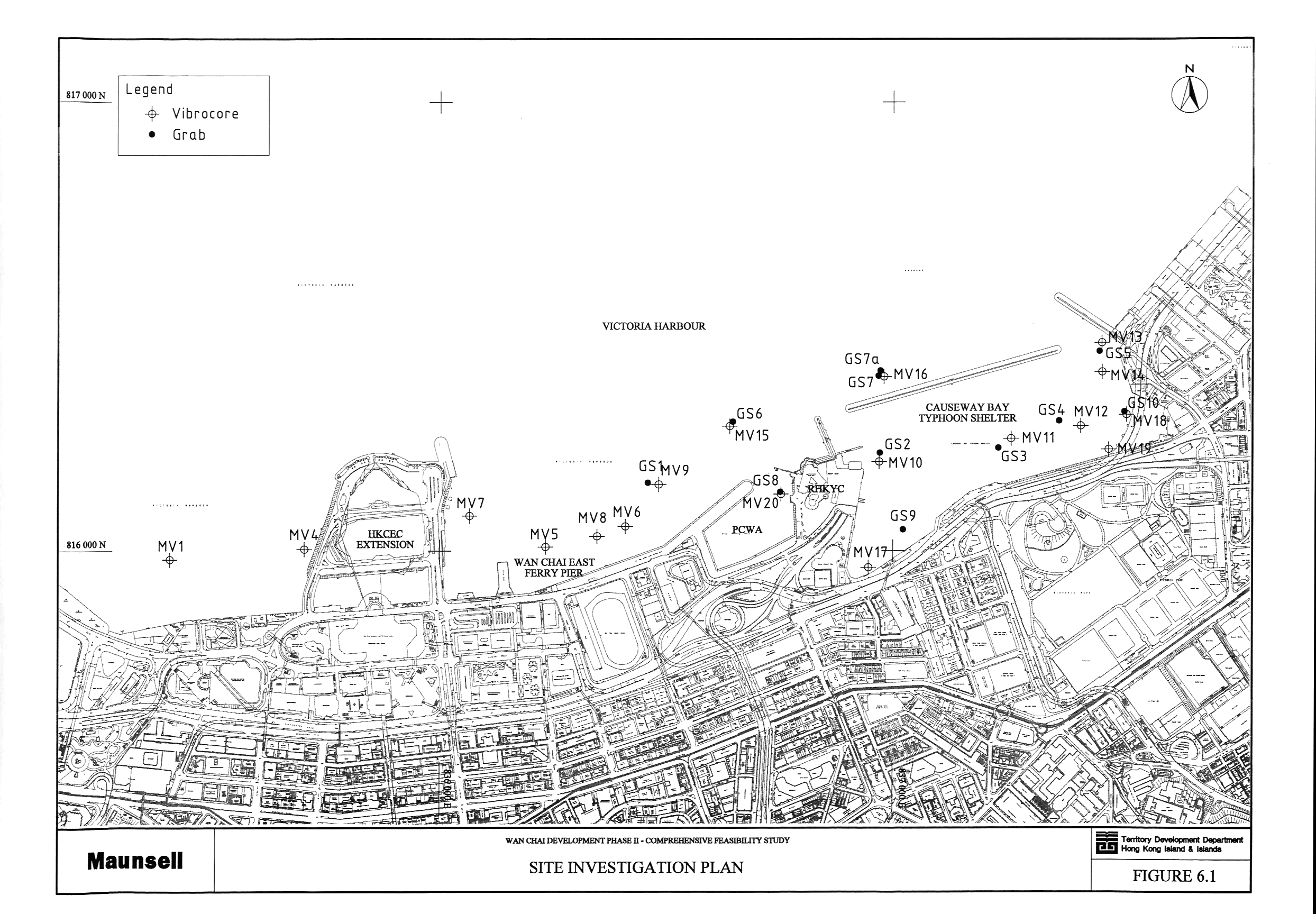