|
Content |
Chapter Title
Figures
Figure
16.1:_ Section
of the Qing scroll showing naval forces (HK Maritime Museum, 2006)
Figure
16.2:_ Cannons
on the main wall of the Tung Chung walled city (photograph S. Heaver)
Figure
16.3:_ Cannon
from the walled city (photograph S. Heaver)
Figure
16.4:_ Shek
She Fort (photograph S. Heaver)
Figure
16.5:_ 1856
French Chart Canal Nord du Lantau (National Maritime Museum London)
Figure
16.6:_ British
Admiralty Chart 1878 (Original kept at United Kingdom Hydrographic Office)
Figure
16.7:_ British
Admiralty Chart 1889 (Original kept at United Kingdom Hydrographic Office)
Figure
16.8:_ Cannon
dredged from the seabed during the airport construction (Meacham, 1994)
Figure
16.9:_ Example
of identified magnetic contact
Photos
Photo
16.1:_ Launching
the sinker
Photo
16.2:_ Marker
buoy for the diver
Photo
16.3:_ Control
Centre for Communication with the diver
Photo
16.4:_ Surface
supplied air helmet
Drawings
MCL/P132/EIA/16-001 MAI Study Area Boundary
MCL/P132/EIA/16-002 Location of Archaeological Sites and Built Heritage
MCL/P132/EIA/16-002b 1:1000 Map Showing Built Heritage Identified within the Study
Area – Sha Chau
MCL/P132/EIA/16-003 Location of Existing AFRF and Routing of Submarine Pipeline
MCL/P132/EIA/16-004 Identified Sonar Contacts with Archaeological Potential
MCL/P132/EIA/16-005 Ha Law Wan Site of Archaeological Interest
MCL/P132/EIA/16-006 Proposed Arrangement for Temporary Power Supply at Sha Chau
Island
Appendices
Appendix 16.1 Extracts of Vessel Track Plots from EGS Geophysical Survey
Report
Appendix 16.2 Hydrophone Track Plots from EGS Geophysical Survey Report
Appendix 16.3 Seabed Levels from EGS Geophysical Survey Report
Appendix 16.4 Seismic Profiler Data from EGS Geophysical Survey Report
Appendix 16.5 Side Scan Sonar Results from EGS Geophysical Survey Report
Appendix 16.6 Data showing Side Scan Sonar Contacts requiring Magnetometer
Survey
Appendix 16.7 Magnetometer Survey Results from EGS Geophysical Survey Report
Appendix 16.9 Summary
Results of Diver Survey
16.1
Introduction
16.1.1.1
This Chapter presents the cultural heritage impact
assessment (CHIA) associated with the project, which has been conducted in
accordance with the requirements of Annexes 10 and 19 of the EIAO-TM, and the
Requirements for Marine Archaeological Investigation stated in Appendix I of
the EIA Study Brief (No. ESB-250/2012).
16.1.1.2
As stipulated in the Clause 3.4.13 of the EIA Study
Brief (ESB-250/2012), the cultural heritage impact shall include a
marine archaeological investigation (MAI), along with a review of terrestrial
cultural heritage, to evaluate the impacts on known or potential cultural
heritage in the study area.
16.1.2 Scope of the CHIA
16.1.2.1
As detailed in Section 4.2, the
main project components comprise land formation and construction and operation
of various built and infrastructure facilities on the existing and expanded
airport island.
16.1.2.2
Marine-based activities have the potential to impact
marine archaeological resources within and outside the boundary of the project
and will be addressed as part of the MAI while land-based activities may affect
terrestrial archaeological resources and built heritage and will be reviewed as
part of the terrestrial cultural heritage (TCH) assessment.
16.1.2.3 The
marine-based activities that may affect marine archaeological resources
include:
¡ Land formation of approximately 650 ha to the
north of the existing airport island;
¡ Construction of new runway approach lights and
the proposed new Hong Kong International Airport Approach Area
(HKIAAA) beacons for the new
‘third’ runway;
¡ Diversion of the 11 kV submarine cable from the
west side of the existing airport island near South Perimeter Road to the
navigable waters at north of existing airport island, 500 m away from Sha Chau and Lung Kwu Chau Marine
Park southern boundary where the proposed cable will be connected to the
existing cable via a field joint; and
¡ Marine site investigation (SI) works within the
Sha Chau and Lung Kwu Chau
Marine Park for diversion of the submarine fuel pipelines.
Land-Based
Activities
16.1.2.4 The land-based
activities that may affect potential terrestrial archaeological resources and
built heritage include:
¡ The daylighting point of the submarine fuel
pipeline from airport island to the aviation fuel receiving facilities on Sha Chau using horizontal directional drilling method;
¡ Provision of temporary power supply to Sha Chau islands during the submarine 11 kV cable
diversion; and
¡ Various modification and improvement works to
existing infrastructure on airport island.
16.1.2.5
Other activities associated with the project that are
not covered in the above are not anticipated to affect cultural heritage
resources.
16.2 Cultural
Heritage Legislation, Standards and Guidelines
16.2.1 General
16.2.1.1 Legislation,
Standards and Guidelines relevant to the consideration of terrestrial and
underwater cultural heritage impacts under this study include the following:
¡ Antiquities and Monuments Ordinance;
¡ Environmental Impact Assessment Ordinance;
¡ Hong Kong Planning Standards and Guidelines;
¡ Technical Memorandum on Environmental Impact
Assessment Process;
¡ Guidelines for Marine Archaeological
Investigation;
¡ Guidelines for Cultural Heritage Impact
Assessment; and
¡ Development Bureau Technical Circular (Works)
No. 06/2009: Heritage Impact Assessment Mechanism for Capital Works Projects.
16.2.2 Antiquities
and Monuments Ordinance
16.2.2.1
Legislation relating to antiquities is set out in the
Antiquities and Monuments Ordinance (Chapter 53 of the Laws of Hong Kong),
which came into force on January 1st 1976. The Antiquities and Monuments
Ordinance provides statutory protection against the threat of development on
Declared Monuments, historical buildings and sites of archaeological interest
to enable their preservation for posterity.
16.2.2.2
The Ordinance contains the statutory procedures for
the Declaration of Monuments. The legislation applies equally to sites on land
and underwater. The purpose of the
Ordinance is to prescribe controls for the discovery and protection of
antiquities in Hong Kong. A summary of the key aspects of the legislation
relevant to the current study is presented below:
16.2.2.3
Human artefacts, relics and built structures may be
gazetted and protected as monuments. The Antiquities Authority may, after
consultation with the Antiquities Advisory Board (AAB) and with the Chief
Executive’s approval, declare any place, building, site or structure which the
Antiquities Authority considers to be of public interest by reason of its
historical, archaeological or paleontological significance.
16.2.2.4
The discovery of an Antiquity, as defined in the
Ordinance must be reported to the Antiquities Authority (the Authority), or a
designated person. The Ordinance also provides that, the ownership of every
relic discovered in Hong Kong after the commencement of this Ordinance shall
vest in the Government from the moment of discovery.
16.2.2.5
No archaeological excavation may be carried out by any
person, other than the Authority and the designated person, without a licence
issued by the Authority. A licence will only be issued if the Authority is
satisfied that the applicant has sufficient scientific training or experience
to enable him to carry out the excavation and search satisfactorily, is able to
conduct, or arrange for, a proper scientific study of any antiquities
discovered as a result of the excavation and search and has sufficient staff
and financial support.
16.2.2.6
Once declared a site of public interest, no person may
undertake acts which are prohibited under the Ordinance, such as to demolish or
carry on building or other works, unless a permit is obtained from the
Antiquities Authority.
16.2.2.7
The Ordinance defines an antiquity as a relic (a
moveable object made before 1800) and a place, building, site or structure
erected, formed or built by human agency before the Year 1800. Sites of
Archaeological Interest are classified into two categories, as follows:
Declared Monument – those that are gazetted in accordance with
Cap. 53 by the Antiquities Authority and are to be protected and conserved at
all costs;
Recorded Sites of Archaeological Interest – those which are considered to be of
significant value but which are not yet declared as monuments and should be
either protected, or if found not possible to protect these sites mitigation
measures should be proposed and implemented to preserve the archaeological
resources. It should also be noted that the discovery of an antiquity under any
circumstances must be reported to the authority, i.e. the Secretary for
Development or designated person. The authority may require that the antiquity
or suspected antiquity is identified to the authority and that any person who
has discovered an antiquity or suspected antiquity should take all reasonable
measures to protect it.
16.2.3 The
Environmental Impact Assessment Ordinance
16.2.3.1
Since the introduction of the 1998 Environmental
Impact Assessment (EIA) Ordinance (Cap. 499, S16), the Antiquities and
Monuments Office (AMO) have the power to request a MAI for developments
affecting the seabed. Its purpose is to avoid, minimise and control the adverse
impact on the environment of designated projects, through the application of
the EIA process and the Environmental Permit (EP) system. The EIA Ordinance
stipulates that consideration must be given to issues associated with sites of
cultural heritage as part of the EIA process. Annexes 10 and 19 of the EIA
Technical Memorandum (EIAO-TM) outline the criteria for evaluating the impacts
on sites of cultural heritage and guidelines for impact assessment,
respectively.
16.2.3.2 The EIAO-TM
identifies a general presumption in favour of the protection and conservation
of all sites of cultural heritage and requires impacts upon sites of cultural
heritage to be ‘kept to a minimum’. There is no quantitative standard for
determining the relative importance of sites of cultural heritage, but in
general sites of unique, archaeological, historical or architectural value
should be considered as highly significant.
16.2.4 Hong Kong
Planning Standards and Guidelines
16.2.4.1 Chapter 10 of the Hong Kong Planning Standards and Guidelines (HKPSG)
details the planning principles for the conservation of natural landscape and
habitats, historical buildings and archaeological sites. The document states
that the retention of significant heritage features should be adopted through
the creation of conservation zones within which uses should be restricted to
ensure the sustainability of the heritage features. The guidelines state that
the concept of conservation of heritage features, should not be restricted to
individual structures, but should endeavour to embrace the setting of the
feature or features in both urban and rural settings.
16.2.4.2 The guidelines
also address the issue of the preparation of plans for the conservation of
historical buildings, archaeological sites and other antiquities. It is noted
that the existing Declared Monuments and Proposed Monuments and archaeological
sites are listed in the explanatory notes of Statutory Town Plans and it is
stated that prior consultation with the Antiquities and Monuments Office (AMO)
is necessary for any development, redevelopment and rezoning proposals
affecting the Monuments and archaeological sites and their surrounding
environments.
16.2.4.3 It is also
noted that planning intention for non-statutory town plans at the sub-regional
level should include the protection of monuments, historical buildings,
archaeological sites and other antiquities through the identification of such
features on sub-regional layout plans. The appendices list the legislation and
administrative controls for conservation, other conservation related measures
in Hong Kong, and Government departments involved in conservation.
16.2.5 Technical
Memorandum on Environmental Impact Assessment Process
16.2.5.1
The general criteria and guidelines for evaluating and
assessing impacts to Sites of Cultural Heritage are listed in Annexes 10 and 19
of the EIAO-TM. It is stated in Annex 10 that all adverse impacts to Sites of
Cultural Heritage should be kept to an absolute minimum and that the general
presumption of impact assessment should be in favour of the protection and
conservation of all Sites of Cultural Heritage. Annex 19 provides the details
of scope and methodology for undertaking Cultural Heritage Impact Assessment,
including baseline study, impact assessment and mitigation measures.
16.2.6 Guidelines for
Marine Archaeological Investigation
16.2.6.1
The AMO have issued Guidelines for Marine Archaeological
Investigation which detail the standard practice, procedures and methodology
which must be undertaken in determining the marine archaeological potential,
presence of archaeological artefacts and defining suitable mitigation measures.
This guideline is included in Appendix I-1 of the Study Brief for this project
(ESB-250/2012).
16.2.7 Guidelines for
Cultural Heritage Impact Assessment
16.2.7.1
This document, as issued by the AMO, outlines the
specific technical requirement for conducting terrestrial archaeological and
built heritage impact assessments and is based upon the requirements of the
EIAO-TM. It includes the parameters and scope for the baseline study,
specifically desk-based research and field evaluation, and impact assessment.
16.2.8 Development
Bureau Technical Circular (Works) No. 06/2009: Heritage Impact Assessment
Mechanism for Capital Works Projects
16.2.8.1
The Technical Circular provides the guidelines and
procedures for assessing heritage impacts arising from the implementation of
capital works projects. It is the responsibility of the works agent to confirm
with the AMO whether there are any “Heritage Sites” within or in the vicinity
of the project boundary. A Heritage Impact Assessment (HIA) would be required
if the AMO decides that the heritage value of any “heritage site” in the
vicinity of the project would be affected. The works agent must then submit a
Study Brief and agree with the AMO on the scope of the HIA. Once the HIA report
has been completed it must be submitted to the AMO for approval.
16.2.8.2
The guidelines also state that it is essential that
every effort be made to minimise adverse impacts on heritage sites. For
projects where the public interest is at stake and where adverse impacts cannot
be entirely mitigated against, the project proponent
and works agent should engage stakeholders and consult them on the proposed
works at the earliest opportunity. It is the responsibility of the works agent
to prepare options for project design, corresponding cost and other
implications for the public to consider. The public engagement strategy should
also be tailored to meet the specific needs of each individual project.
Finally, during the construction phase it is the responsibility of the works
agent to ensure that the works and mitigation for heritage conservation are
being carried out as stipulated in the HIA Report and approved by the AMO.
16.3
Assessment Methodology
16.3.1
Study Area
16.3.1.1
The MAI study area for the project covers the seabed
areas that will be impacted during the construction and operation phases. This
includes the proposed
airport expansion footprint, the tentative alignment of the submarine 11 kV
cable as well as the proposed new HKIAAA beacons to the north of the proposed
airport expansion area. The MAI study area is shown in Drawing No. MCL/P132/EIA/16-001. The alignment
of the two submarine fuel pipelines to Sha Chau Island and the associated marine SI works within Sha Chau and Lung Kwu Chau Marine
Park are not covered in the MAI study area as marine SI works typically do not
require MAI (given that they affect a very small area of seabed only), while
the pipelines will be constructed using the HDD method, which involves drilling
through the sub-sea
bedrock before surfacing on the small island north of Sha Chau Island (known as Sheung Sha Chau Island). With this construction method, there will be no direct disturbance to
Sha Chau Island. Potential indirect disturbance due
to vibration would be expected to be insignificant given that the two drillholes will only be less than 1 m in diameter each and
the drilling depth will be largely about 50 m below the seabed. Therefore,
marine archaeological investigation is not required for the submarine fuel
pipelines and the associated marine SI works.
16.3.1.2
The TCH study area for the project covers a radius of
500 m from the boundary of all land-based areas that will be impacted during the
construction and operation phases. This includes the daylighting point of the submarine fuel pipelines on Sheung Sha Chau Island where the AFRF is located and the
existing airport island.
16.3.1.3
The cultural heritage impact assessment has been
divided into the identification of marine and terrestrial cultural heritage
impacts. The methodology for each of these tasks is outlined below and in the
subsequent sections:
16.3.2
Marine Archaeology
16.3.2.1
As specified in Appendix I of the EIA Study Brief, the
requirements for MAI follow the Guidelines for Marine Archaeological
Investigation issued by the Antiquities and Monuments Office (AMO). The
guidelines specify the following tasks:
1.
Baseline Review;
2.
Geophysical Survey;
3.
Establishing Archaeological Potential; and
4.
Underwater Inspection (Remote Operated Vehicle (ROV)
/ Visual Diver Survey / Watching Brief).
16.3.2.2
The aim of the MAI is to locate, identify and assess
the significance of any underwater archaeological resources that may be
impacted by the proposed land formation and associated engineering works. A
qualified marine archaeologist was engaged to conduct the MAI. Details of the
specific tasks for the MAI of this project are provided as follows.
16.3.2.3
The baseline review
covers the known sources of archive data as described in Clause I. (1) 1.2 of
Appendix I-1 of the EIA Study Brief. In particular, the research is to
establish if there are any records of shipwrecks occurring within the proposed
MAI study area and its immediate vicinity, as evidence of shipwrecks will
increase the likelihood of marine archaeological remains being present. The
research included Hong Kong archives, reports held by the AMO, examination of
old navigation charts, archaeological, historical and geological publications.
16.3.2.4
A geophysical survey
is the most effective method to assess the seabed and subsurface for
archaeological material. Geophysical surveys typically involve side scan sonar,
seismic profiler (boomer), multi-beam swath, echo sounder, and global
positioning systems.
Side Scan Sonar
16.3.2.5
The side scan sonar is used to map objects on the
seabed and scars or unusual seabed features (anomalies) which may be indicative
of buried archaeological material. Under optimum survey conditions, it is
possible to image objects with lateral dimensions of a few centimetres. With
careful planning of the survey it is possible to achieve 200 % coverage of the
seabed by overlapping the records from adjacent ship-tracks.
16.3.2.6
The side scan range was set at 50 m (total 100 m wide
scanned image) during the survey and the survey traverses was run at 40 m line
intervals to ensure more than 200 % coverage. Anomalies of apparent
archaeological potential would be ‘boxed’ by at least two and preferably four
lines along and across the principal axis of the anomaly. These lines were
offset so that the anomaly does not lie immediately beneath the fish of the
sonar, and were run at optimal frequency and range settings for imaging the
anomaly.
Seismic Profiler
16.3.2.7
This system provides information about the structure
of the seabed sediments to depths of several tens of metres or more. This enables
investigation of buried features and establishment of the sub-marine
stratigraphy. The data collected also facilitates assessment of the
preservation potential of the sediments.
16.3.2.8
The boomer is capable of resolving all significant
changes in impedance generating reflectors to within 0.5–1.0 m, to a depth of
15 m below the seabed. Sub-bottom survey was carried out using a source capable
of resolving internal structures to the full depth of anticipated scheme
impacts within Quaternary deposits. Line and cross-line spacing and
orientations were sufficient to resolve the extent and characteristics of the
principal Quaternary deposits. A single beam echo sounder was run in
conjunction with the sub-bottom survey; the first reflector (seabed) was
levelled with reference to a tide gauge.
Multi Beam Swath
Survey
16.3.2.9
Multi beam survey is carried out using a system
capable of achieving an effective cell / bin size better than 1 m. Use of a
beam-forming system was adopted where possible. Where an anomaly of apparent archaeological
potential is identified, an additional single slow pass was carried out at the
highest possible ping rate. Single beam and multi beam data was made available
as cleaned, de-spiked and tidally-corrected text (x,y,z) files for each line, in addition to any gridded
/ rendered surfaces.
Echo Sounder
16.3.2.10
The echo sounder is a core element in any hydrographic
survey, its function being to provide a high-resolution trace of the seabed
with accurate depth measurements. This data is essential for planning any
subsequent diving survey.
Horizontal Location
Control
16.3.2.11
Differential Global Positioning System (DGPS) was
deployed to ensure accurate location of targets. Each update (<2 seconds) of
the positioning data together with the sounding data was logged by computer
during the survey. Fix numbers with positioning was recorded separately at
intervals of 5-10 seconds and was printed onto the seismic and side scan sonar
records.
16.3.2.12
The results of the geophysical survey are presented as
a Seabed Features chart at 1:1,000 scale giving seabed types and any anomalous
features. A list of the co-ordinates of all anomalous features is provided in
WGS 84 Latitude and Longitude co-ordinates and Hong Kong metric grid.
Establishing
Archaeological Potential
16.3.2.13
Upon completion of
the geophysical survey, the geophysical data sets were reviewed and analysed in
detail and integrated with the results of the baseline review to identify and
map features and anomalies with archaeological potential. Areas identified with
archaeological potential would be subject to further investigation via
underwater inspection.
16.3.2.14
Where anomalies are identified in the geophysical
survey data, visual inspection and assessment is conducted. This may involve
visual diver survey or use of remote operated vehicle (ROV). The marine
archaeologist shall apply for a Licence to
Excavate and Search for Antiquities under the Antiquities and Monuments
Ordinance before conducting the diving inspection. The methodology for
the diver survey shall be agreed with AMO.
16.3.3 Terrestrial
Cultural Heritage
16.3.3.1 For
terrestrial cultural heritage, a literature review and desktop study were
undertaken to identify any baseline terrestrial cultural heritage resources
within the project area. Information reviewed included published papers,
reports, and historical documents from the Antiquities and Monuments Office,
public libraries and tertiary institutions. If the available information is
inadequate for identifying and assessing the cultural heritage resources that
may be impacted by the proposed project, field surveys would be conducted to
supplement the data.
16.3.4
Impact Assessment and Mitigation Measures
16.3.4.1 Based on the findings of the MAI survey and the TCH review, the nature
of the potential impact to identified cultural heritage resources has been
assessed. Where applicable, preservation in totality has been taken as first
priority. Where adverse impact to archaeological or built heritage resources
cannot be avoided, appropriate mitigation measures have been recommended.
16.4 Baseline Review
16.4.1
Information Sources
16.4.1.1 The baseline review included a study of information from the following
sources:
¡ Past projects in the vicinity including
approved EIAs from the Environmental Protection Department’s EIAO Registrar;
¡ Archive information from the UK Hydrographic
Office (formerly the Royal Naval Hydrographic Department);
¡ Information from the Marine Department,
Hydrographic Office;
¡ Relevant publications from the Geotechnical
Engineering Office;
¡ Marine chart records held in the British
Library and the National Maritime Museum Library in London;
¡ Publications on local historical,
anthropological, archaeological and other cultural studies; and
¡ Unpublished papers, records, archival and
historical documents held in local libraries and other government departments.
16.4.1.2 The findings of the marine archaeological review, terrestrial
archaeological review and built heritage review are described below.
16.4.2
Marine Archaeological Review
16.4.2.1 The North
Lantau area covers one of the most historically significant (strategic) waterways
in Hong Kong as it was the main route for ships travelling to the Pearl River
Estuary and on to Canton. Both Tuen Mun and Tung Chung have
exceptionally rich and well documented maritime histories including sea battles
and intense pirate activities. The fort
and battery are still in situ at Tung
Chung. Therefore, in addition to the study of Chek
Lap Kok, historical information about Tung Chung is
included. The study area for the baseline review therefore covers a broader
area than the study area to provide a comprehensive context.
Historical Background of Chek
Lap Kok
16.4.2.2
The island of Chek Lap Kok first appears in late Ming historical documents under
the name ‘Chek Lap Chau’. The name apparently derives from a fish
formerly called ‘chek lap’ (now known as ‘lap yue’) that was abundant in the waters around the island.
The first reference to the island in western sources is a brief mention
(referred to as the island of ‘Shatlapko’) in a
British naval reconnaissance report by Lt. H.W. Parrish in 1794. There is no mention of any inhabitants of the
island or the type of land use (Schofield, 1983).
16.4.2.3
Meacham (1994) noted that “The history of Chek Lap Kok spans the entire
period of human occupation in the Hong Kong area, from the earliest inhabitants
of the painted pottery period around 4000 BC to the recent period.” As part of
the rescue archaeological project carried out on Chek
Lap Kok before the construction of the international
airport, archaeological work was carried out on several sites on Chek Lap Kok, including a
8th-10th century site encompassing kilns and coins; burial sites of the
Northern Sung period; a site containing pottery from the Middle and Late
Neolithic period (4000-1500 BC); burial/ritual sites dated 3700-3400 BC; a
number of Tang lime kilns (dated 750 and 1200 AD); and a site containing hard
and soft geometric pattern pottery, axe moulds and cloth from the Bronze
age.
16.4.2.4
The first detailed evidence of human occupation on the
island from written sources is the land use survey carried out in 1904-5 by
British Army Indian surveyors, as part of the general registration of land
ownership in the New Territories. This
record reveals an elaborate and complicated web of ownership and land use (Empsom, 1992).
16.4.2.5
In 1809, the nearby Tung Chung Bay area became a
battlefield for pirates and the Qing navy.
The book ‘History of the Pirates who infested the China Seas from 1807
to 1810’ (Neumann,1831) gives a very detailed record
of that incident:
“ … In consequence of this determination all commanders and officers of the different vessels were ordered to meet on the seventeenth at Chek Lap Kok, to blockade the pirates in Ta Yu Shan, and to cut off all supplies of provisions that might be sent to them. To annoy them yet more, the officers were ordered to prepare the materials for the fire-vessels. These fire-vessels were filled with gunpowder, nitrate and other combustibles; after being filled, they were set on fire by a match from the stern, and were instantly all in a blaze. The Major of Heang Shan, Pang Noo, asked permission to bring soldiers with him, in order that they might go ashore and make an attack under the sound of martial music, during the time the mariners made their preparation. On the twentieth it began to blow very fresh from the north, and the commander ordered twenty fire-vessels to be sent off, when they took driven by the wind, an easterly direction; but the pirates’ entrenchments being protected by a mountain, the wind ceased, and they could not move father on in that direction; they turned about and set on fire two men of war. The pirates know our design were well prepared for it; they had bars with very long pincers, by which they took hold of the fire-vessels and kept them off, they that they could not come near. Our commander, however, would not leave the place; and being very eager to fight, he ordered that an attack should be made, and it is presumed that about three hundred pirates were killed. Pao (i.e. Cheung Pao Tsai) now began to be afraid, and asked the Spirit of the Three Po, or old Mothers to give a prognostic. The Puh, or lot for fighting was disastrous; the Puh, or lot to remain in the easterly entrenchment, was to be happy. The Puh, or lot for knowing if he might force the blockade or not on leaving his station tomorrow, was also happy, three times one after another.
There arose with the daylight on the twenty-second a light southerly breeze; all the squadrons began to move, and the pirates prepared themselves to joyfully leave their station. About noon, there was a strong southerly wind, and a very rough sea on. As soon as it became dark the pirates made sail, with a good deal of noise, and broke through the blockade, favoured by the southerly wind. About a hundred vessels were upset, when the pirates left Ta Yu Shan. But our commander being unaware that the pirates would leave their entrenchments, was not prepared to withstand them. The foreign vessels fired their guns and surrounded about ten leaky vessels, but could not hurt the pirates themselves; the pirates left the leaky vessels behind and ran away”
16.4.2.6
Whatever the truth of the details of the battle, there
is no question that at the end of the nine day battle the pirates were not
defeated. However Cheung Po Tsai
eventually surrendered in 1810 to the Viceroy Bailing of the Qing
government. At the time of surrender he
had over 270 junks, 16,000 men, 5,000 women, 7,000 swords and 1,200 guns (Cortesão, A. 1944.).
These figures clearly indicate the scale of the pirate activities in the
region (Murray, 1987).
16.4.2.7 A remarkable 18 m long Qing Dynasty scroll painted on silk depicts the actions of the Viceroy Bailing
(c.1748-1816) from his assumption to office in 1809 to the successful solution
to the piracy problem in the summer of 1810. It is divided into 20 ‘episodes’
and includes the pirate battle at Tung Chung (see Figure 16.1). The scroll is on display at the new maritime
museum at Pier 4, Central.
Figure 16.1: Section of the Qing scroll showing naval
forces (HK Maritime Museum, 2006)
16.4.2.8
With the surrender of the pirates in 1810, the
inhabitants of Chek Lap Kok
were able to live in peace and continue their intensive farming and
quarrying. The large amount of granite
produced on the island favoured the development of granite quarrying. The products were used to build roads and
houses in the developing city of Hong Kong.
16.4.2.9
Some fishermen made use of the coastal area for
repairing their boats and for drying their fishing nets. Thus on the north coast of the island there
was a Tin Hau temple built in 1823. The temple was built of granite with money
donated by some quarry companies.
16.4.2.10
After World War II, the quarrying activity declined
and many people moved to the city for better employment. By the 1950s, only about 200 people lived on
the island.
The Tung Chung Walled City (東涌所城), also known as Tung Chung Fort (東涌炮台)
16.4.2.11 The disruption and danger posed by the pirates led to the building of
the Tung Chung walled city, also known as the Tung Chung
Fort (Lui, 1990). It was built on
a piece of land between Sheung Ling Pei and Ha Ling
Pei villages in the Tung Chung Valley. It was built in 1832 by Ho Chun Lung a
captain from the Chin Shan Battalion of the Heung Shan Brigade.
16.4.2.12 The walled city backs up against the Tai Tung mountain.
Its four rubble filled walls enclose an area of 225 ft
by 265 ft and the more formidable front wall runs to
about 15 ft thick.
Along the main wall can be seen six old muzzle loading cannons each
fixed to a cement base. There are two on the western side and four on the
eastern side (see Figure 16.2
and Figure 16.3).
They bear inscriptions but only four out of the six are still legible. They detail the casting of each cannon: for example the inscription on the second one
from the east states that it was cast in the 8th moon of the 14th year of the Jiaqing reign (1809), serial number Qing 80, weighing 1,000 catties and was
cast by the master of the Man Shing Furnace.
16.4.2.13 At this time the pirate Cheung Po Tsai had a very strong influence on
Lantau Island. The governor-general of Kwangtung and Kwangsi, Viceroy
Bailing, was responsible for suppressing Cheung and
his colleagues. He organised the casting of cannons and had them mounted
throughout the coastal regions so that the area become more strongly fortified
against Cheung’s attacks. All the
cannons that he cast bore serial numbers.
16.4.2.14 On the eastern side of the main gate one of the cannons was cast in the
1st moon of the 10th year of the Jiaqing reign (1805) and
weighs 1,200 catties. It is highly
likely that this cannon was also used for the defence
of the region against piracy. The cannon lying next to the one above has been
severely weathered and its inscription is illegible. Two further cannons are
dated to 1841 and were probably used for defence against the British and the
opium traders (Siu, 1982).
Figure 16.2: Cannons on the main wall of the Tung Chung
walled city (photograph S. Heaver)
Figure 16.3: Cannon from the walled city (photograph S. Heaver)
16.4.2.15 It is clear from the differing casting dates that the cannon were cast
elsewhere and transported. Although they
have been cast over a period of four decades they all shared the same purpose
of defending the region against pirates and foreign invaders.
16.4.2.16 The Tung Chung
Fort is a declared monument protected by the Antiquities and Monuments
Ordinance (Cap.53).
Shek She
Fort (石獅山炮台), also known as Tung Chung Battery (東涌小炮台)
16.4.2.17
Further evidence for the severity of the pirate threat
is demonstrated by the presence of Shek She Fort (see Figure 16.4),
also known as Tung Chung Battery (Siu, 1979). Tung Chung is in a valley
surrounded by hills on three sides and faces the sea to the north. The valley
is well drained by streams and provides fertile land for farming. As the
entrance to Tung Chung a low lying hill known as the Shek
She Shan (the rocky lion mountain) is situated.
The Shek She Fort is found on the mountain’s north slope.
16.4.2.18 The fort was built in 1817 in order to strengthen defences on the
northern coast of Lantau Island and to guard the Tuen
Mun waterway. It had two cannon places, seven guard
houses and an ammunition store. To its
south at the entrance to Tung Chung was the Tung Chung Hau
Shuen (with eight guard houses) built in the same
year. It is strategically placed to have the optimum view across Tung Chung Bay
to locate any water based attackers. The fort and the guard houses together had
a garrison of 30 soldiers under the command of a patsung sent from the Tai Pang
Battalion (Siu, 1978).
16.4.2.19 There is little documented evidence about the fort after 1877 and its
existence seemingly was forgotten. In 1980 rubble walls were found on a knoll
near the Tung Chung ferry pier 1 km north of the Fort. They are completely ruined but likely to form
one to the two cannon places of the Shek She Fort. The Tung Chung
Battery is a declared monument protected by the Antiquities and Monuments Ordinance
(Cap.53).
Figure 16.4: Shek She Fort
(photograph S. Heaver)
Maritime Archives
16.4.2.20 The UK
Hydrographic Office (UKHO) holds a database of surveyed shipwrecks in Hong
Kong, including those not shown on Admiralty Charts. The database contained no
records of shipwrecks within or close to the study area.
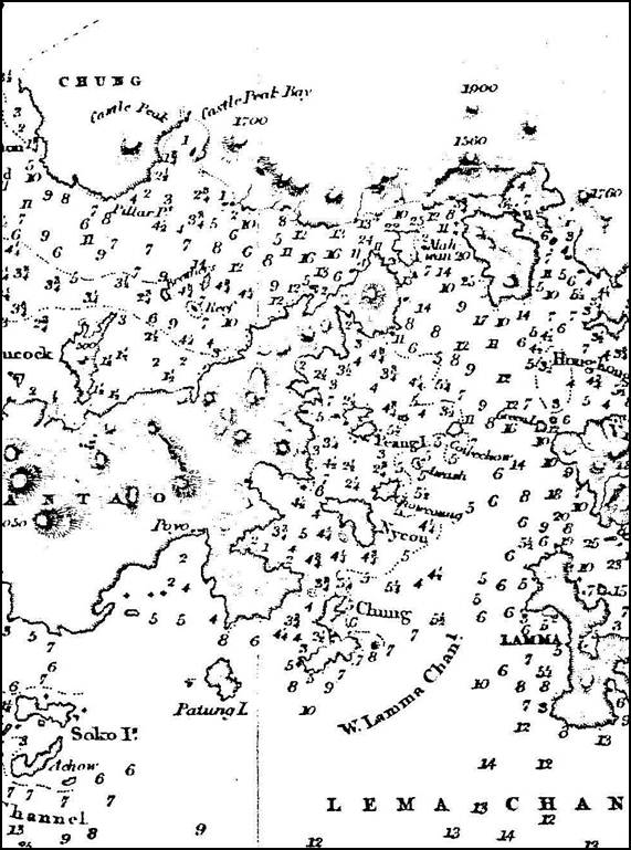
16.4.2.21 Historic
charts of the study area include French Admiralty 1856 (Figure 16.5),
1878 (Figure 16.6),
and British Admiralty Chart 1899 (Figure 16.7).
Figure
16.5: 1856 French Chart Canal Nord du
Lantau (National Maritime Museum
London)
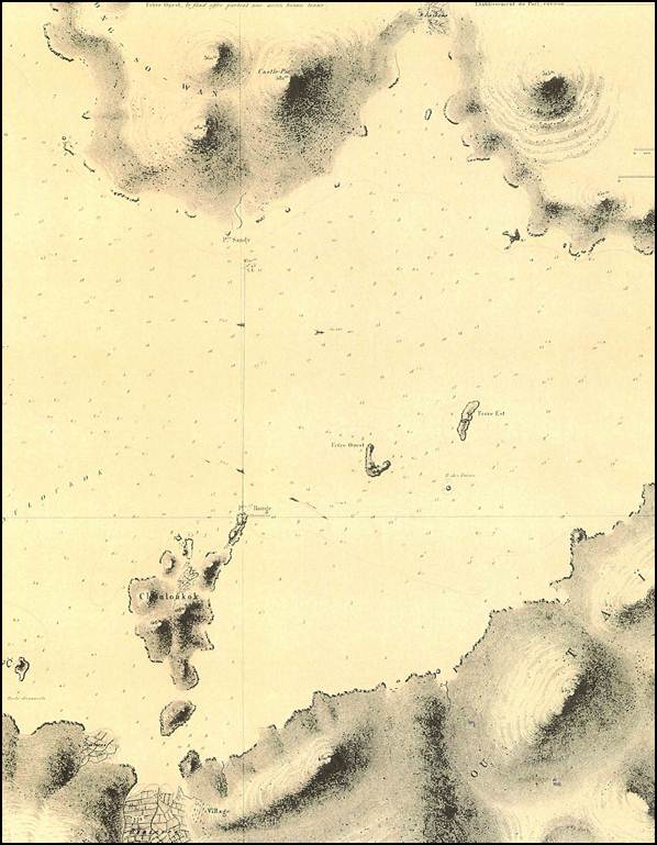
Figure 16.6: British
Admiralty Chart 1878 (Original kept at United Kingdom Hydrographic
Office)
Figure
16.7: British
Admiralty Chart 1889 (Original kept at United Kingdom Hydrographic
Office)
Marine
Archaeological Artefacts
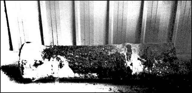
16.4.2.22 During the
dredging of the seabed between Chek Lap Kok and Tung Chung for the new airport in 1993, part of a
cannon and a cannon ball were discovered and reported to the Provisional
Airport Authority (see Figure 16.8).
An inscription on the cannon reveals that it was manufactured around 1808 in
China (Meacham, 1994). There is no way
of knowing its exact origin but it is the only evidence that has been found for
the 1809 battle between the Qing Navy and the Pirates. The cannon was
located buried within the marine mud and assumed to be originated from a ship
but it is also possible that it was a land cannon that accidentally became
submerged.
Figure 16.8: Cannon dredged from the seabed during the
airport construction (Meacham, 1994)
16.4.2.23 A geophysical
survey was conducted as part of the MAI for the New Contaminated Mud Marine Disposal
Facility at Airport East / East Sha Chau Area project
(AEIAR-089/2005), which partially overlaps the MAI study area for this project;
however, no evidence for marine archaeological resources was identified. The
MAI study area for other projects in the vicinity was also reviewed, but none
of these overlap with the MAI study area for this project.
16.4.3
Terrestrial
Archaeological Review
16.4.3.1 Terrestrial archaeology within the TCH study area is well documented due
to the large number of past and current development projects in the area, which
includes the studies completed as part of the construction of the original HKIA
and more recent studies that were completed as part of the Hong Kong – Zhuhai –
Macao Bridge – Hong Kong Link Road project. Information from these studies and
other literature sources as well as the latest information from the AMO has
been reviewed.
16.4.3.2 The AMO
maintains an up-to-date list of all designated sites of archaeological interest
in Hong Kong. A review of the AMO’s List of
Sites of Archaeological Interest in Hong Kong (last updated in November
2012) has identified six sites of archaeological interest which wholly or
partially lies within the 500 m study area boundary. Of these six sites, there
are two sites that are located within the project boundary. The Ha Law Wan site
of archaeological interest is located within the project boundary on the
southern part of Chek Lap Kok
Island on Scenic Hill. The Sha Chau site of
archaeological interest lies directly above the drilling activities for the
submarine aviation fuel pipelines from the airport island to the AFRF north of Sha Chau Island, and is the site where the temporary power
supply to Sha Chau will be provided. The remaining
four sites of archaeological interest lie partly within the study area, but are
outside the project boundary. The locations of all six sites of archaeological
interest within the study area are shown in Drawing No MCL/P132/EIA/16-002.
These six sites of archaeological interest are briefly described below.
Ha Law Wan Site of
Archaeological Interest
16.4.3.3 The Ha Law Wan
site was recorded in an archaeological survey conducted as part of the salvage
excavations on Chek Lap Kok
in 1990 (prior to construction of the existing airport island), which
identified seven sites of archaeological interest in total. Results from this
survey found middle Neolithic pottery, Bronze Age burials and Tang period lime
kilns; however six of the sites have since been removed following the excavation
and recording. The site of archaeological interest still remaining is at Ha Law
Wan. The site consists of a complex of Yuan period kilns, which is currently
preserved and set aside as a visitor area by the Airport Authority on the
northern lower slope of Scenic Hill.
Sha Chau Site of Archaeological Interest
16.4.3.4 The Sha Chau site of archaeological interest,
covering the larger Sha Chau Island (but excluding
the Sheung Sha Chau
Island), was identified with considerable quantity of prehistoric and
historical artefacts discovered covering the Neolithic Period and the Bronze
Age, as well as the Sui, Tang and Five Dynasties, the Song and Yuan Dynasties,
and the Ming and Qing Dynasties. This includes many significant Late Neolithic
artefacts and relics.
Fu Tei Wan Kiln Site of Archaeological Interest
16.4.3.5 The Fu Tei Wan Kiln site was originally located on Chek Lap Kok Island but has been
removed during construction of the airport. Artefacts associated with the Sui,
Tang and Five Dynasties were recorded. Prior to construction of the airport, a
lime kiln (dated from Tang dynasty) was relocated to the site of the Tung Chung
Battery and is placed in an outdoor display.
San Tau Site of
Archaeological Interest
16.4.3.6 This site
covers an alluvial plain as well as lower hillside slopes. As part of the
Northern Lantau Archaeological Survey in 1991, an abundance of artefacts
covering the Neolithic Period, Qin, Han and Six Dynasties, Sui, Tang and Five
Dynasties, Song and Yuan Dynasties were uncovered.
Sha Lo Wan Site of Archaeological Interest
16.4.3.7 This site
covers a large, formerly estuarine area and slopes including the village of Sha Lo Wan Tsuen. The Northern Lantau Archaeological Survey
in 1991 unearthed abundant artefacts including Tang period kiln debris and Song
period pottery, as well as other artefacts dated to the Neolithic Period and
Bronze Age.
Sha Lo Wan (West) Site of Archaeological Interest
16.4.3.8 This site of archaeological interest was first recorded by Healey and Shellshear in the 1920s and is understood to be formerly a
Late Neolithic promontory site with an abundance of artefacts. Several
prehistoric pottery shards were collected by the First Territory-wide Survey in
1983. Sub-surface investigation as part of the Northern Lantau Archaeological
Survey in 1991 confirmed the archaeological
significance of the site. Rescue excavation was conducted in 1993 prior to
removal of the headland for airport works. The remaining headland has traces of
Tang and Neolithic period artefacts.
16.4.3.9 Aside from the aforementioned sites of archaeological interest, no other
sites of archaeological potential are anticipated within the project area,
given that the existing airport island is founded on reclaimed land and the
remnants of the original Chek Lap Kok
Island was extensively surveyed and excavated prior to construction of the
airport. Potential impacts on unknown archaeological deposits within the
project area are thus considered to be unlikely.
16.4.3.10 At Sheung Sha Chau Island (where the
works area for the submarine aviation fuel pipelines are located), the literature
review did not identify any record of previous archaeological findings on this
island, despite the relatively abundant records of archaeological findings at
the nearby Sha Chau Island. Construction activities
on this island will comprise drilling of the pipelines through the bedrock,
where the pipelines will surface on dry land near the existing AFRF and the
fuel pipes will be laid along the existing emergency walkway connecting to the
existing fuel pipelines at the AFRF (details shown in Drawing No MCL/P132/EIA/16-003).
Given that the proposed fuel pipelines will be drilled through the granite
outcrop and the daylighting point will be above the high tide mark, the
archaeological potential of the works area on Sheung Sha Chau is considered to be low, and no further assessment
is considered necessary.
16.4.4 Built Heritage
Review
16.4.4.1 As with terrestrial archaeology, built heritage within the TCH study
area is also well documented due to the large number of past and current development
projects in the area. Information on historical buildings and structures
documented from past studies as well as the latest information from the AMO has
been reviewed.
16.4.4.2 The AMO
maintains an up-to-date list of all built heritage in Hong Kong. Based on a
review of the AMO’s List of the Historic
Buildings in Building Assessment (last updated in 17 December 2012), there
are no built heritage features located within the boundary of the project. The
locations of built heritage features in the study area are shown in Drawing No
MCL/P132/EIA/16-002 and Table 16.1
below.
Table 16.1: Summary
of Built Heritage located within the TCH Study Area
|
Built Heritage |
Distance to Project Boundary |
Distance to Nearest Works Area* |
Description |
|
Tung Chung Battery (東涌小炮台) |
390 m |
570 m |
Tung Chung Battery is an early 19th century fort located at the foot of the ‘Rocky Lion Hill’ on the eastern side of Tung Chung Bay. It is also known as the Shek She Fort (石獅山炮台). It is a declared monument. |
|
Tin Hau Temple (天后廟) |
345 m |
545 m |
The Tin Hau Temple at Sha Chau (Nil Grade) was first built by fishermen during the Qing dynasty, but was destroyed in a fire in the 1970s. It was rebuilt in 1998. |
* This refers to areas within the project boundary
where actual construction activities are proposed.
16.4.4.3 Plans (in 1:1000 scale) showing the built heritage are provided in Drawing No
MCL/P132/EIA/16-002a and Drawing No MCL/P132/EIA/16-0002b.
16.4.4.4 At Sheung Sha Chau Island, the
baseline review did not identify any built heritage features on this island. A
site walkover survey was attempted on May 2013 but due to dense vegetation and
rugged terrain, many parts of the island was not accessible and no signs of
previous or existing paths were found. Within the areas which could be
accessed, no built heritage features (structures, graves, cultural landscapes
or any other sites of historical significance) were identified on Sheung Sha Chau Island. Based on
this initial review, the potential for any built heritage to be located on Sheung Sha Chau Island is
considered to be unlikely and no further assessment is considered necessary.
16.5
Evaluation and Assessment of Cultural Heritage Impacts
16.5.1 Marine
Archaeological Investigation
16.5.1.1 The findings of the baseline review have identified a need for
undertaking further investigation of the marine archaeological potential of the
project area. A geophysical survey was conducted to obtain further information.
Geophysical Survey
16.5.1.2
The geophysical survey was completed in December 2012,
covering the entire MAI study area as shown in Drawing No. MCL/P132/EIA/16-001. Fugro Geotechnics Ltd was the
main investigation contractor and EGS (Asia) Ltd were the sub-contractor for
the survey. The equipment mobilised for the geophysical survey is shown in Table 16.2.
Table 16.2: List of Equipment Used
|
TYPE |
MANUFACTURER |
PURPOSE |
|
Seismic profiler |
Low voltage boomer |
To profile the sub-seabed geological succession |
|
Side Scan Sonar |
Edgetec in USA |
To map seabed features such as shipwrecks, rock outcrops, sediment types and dumped materials. |
|
Dual Frequency Echo Sounder (200kcs and 30kcs) |
Knudsen in Canada |
To map the water column thickness along the vessel track: these thicknesses are converted into depths below Principal Datum (PD) using corrections from the three recording tide gauges |
|
Swath (multi-beam) echo sounding system |
R2Sonic |
To map the complete sea bed, along and between survey lines |
|
Tide Gauge |
Valeport in the UK |
To record the water surface level which is moved up and down by the tide |
|
Marine magnetometer |
Seaspy |
To record variations in the earth’s magnetic field; the location of metal objects such as cannon can be recorded using this instrument. |
|
Positioning system |
C-nav Globally corrected Global Positioning System (GPS) |
To position the survey vessel to +/- 0.5 m updated every 0.5 seconds |
|
On board software |
EGS navigation software EGS seismic acquisition system EGS magnetometer display system Edgetec side scan operating system |
|
16.5.1.3 The MAI survey area was systematically surveyed along set vessel tracks.
The tracks of the survey vessels within the MAI study area are shown on the
track plots in Appendix 16.1. Hydrophone track plots within
the MAI study area are shown in Appendix 16.2. Seismic, side scan sonar and echo sounding
data were collected in digital form.
16.5.1.4 The geophysical survey data obtained were processed using C-Nav interpretation and processing software and
interpretation of the seismic data which were then digitised and used for
plotting and contouring. The results are presented in a series of summary
drawings which provided a very accurate three-dimensional representation of the
seabed.
16.5.1.5
The water depth across the study area is at its
shallowest adjacent to the airport at 2.2 m and the deepest water (excluding the
dredged areas for the active CMPs and the existing submarine aviation fuel
pipelines) is at the east of the study area which is up to 12 m. The detailed results within the MAI study
area are presented in Appendix 16.3. The charts also show the disturbed seabed in
the vicinity of the contaminated mud pits (CMPs).
16.5.1.6
The results of the seismic profiler within the MAI
study area are presented in Appendix 16.4, which show the base of the
Holocene sediments, also called the Marine Deposits. These sediments are assigned to the Hang Hau Formation. The formation consists of relatively
homogenous very soft to soft, greenish grey silty
clay (Fyfe et al., 1997) and has high moisture content. Therefore, the Hang Hau Formation sediments potentially provide an excellent
substrate for the preservation of archaeological material. Additionally, the
soft nature of the sediments would make it possible for archaeological material
to be buried within the formation, where it would have greater protection than
if it were exposed on the seabed.
16.5.1.7 Across the study area the depth of the Holocene sediments has a minimum
of 19 m and maximum of 36 m. There is a
buried channel approximately 500 m wide running east-west across the study
area.
16.5.1.8 The seismic data were used to establish the full geological succession
including the top of rock in any state of decomposition. The marine archaeological assessment is only
concerned with the data for the levels of the base of the Holocene as this is
the only horizon in which archaeological remains could be located.
16.5.1.9 No seismic data were obtained in the areas of the contaminated mud pits
as the sand capping completely blocks the seismic penetration. No seismic
contacts were identified in the data.
16.5.1.10
The summary charts of the side scan sonar survey
within the MAI study area are presented in Appendix 16.5. The charts show the location
of the following features:
¡ Sonar Contacts;
¡ Detailed distribution of surficial sediment
types;
¡ Location of dumped material;
¡ Existing airport boundary;
¡ Contaminated mud pits;
¡ The existing fuel pipeline, pipeline trench and
power cables;
¡ Previous and proposed boreholes; and
¡ Artificial Features.
16.5.1.11
A total of 41 side scan sonar contacts were
located. The marine archaeologist has
reviewed the data and 22 contacts were deemed to have archaeological potential
(shown in Drawing
No MCL/P132/EIA/16-004). The selection process involved removing sonar
contacts that were associated with modern features such as mooring buoys,
naturally occurring rocks, and modern debris. The data showing each of the 22
unidentified sonar contacts which were deemed to have archaeological potential
are presented in Appendix 16.6. It should be noted that six
of these sonar contacts are located near the edge of the CMPs, and while the
CMPs are considered to have no archaeological potential, it was considered
prudent to obtain further information on these sonar contacts located on the
edge of the CMP boundaries before reaching a conclusion on their archaeological
potential.
16.5.1.12
A magnetometer survey was mobilised to obtain additional
information about the 22 sonar contacts.
Due to permit and site constraints, the survey was completed in three
separate phases between the 1 and 14 March 2013.
16.5.1.13
The magnetometer survey was completed by a
commercially licensed vessel using the equipment listed in Table 16.3
below:
Table 16.3: Equipment
for Magnetometer Survey
|
EQUIPMENT |
|
C-Nav GcGPS |
|
The EGS computerised navigation package v.1.3 and PC |
|
Knudsen echo sounder |
|
SeaSpy marine magnetometer |
16.5.1.14 The survey vessel was located by C-Nav
GPS. The system was checked for accuracy
by placing the GPS antenna at a control point at which the recorded
co-ordinates were compared with the known co-ordinates. In this case, the control point was an EGS
control station located in the Tuen Mun Typhoon shelter.
An accuracy of +/- 1 m was ensured by carrying out the above quality
control check before the surveys commenced.
16.5.1.15 During the surveys, the magnetometer was towed astern of the survey
vessel at a layback of about 20 m. The
magnetometer was kept at 2-3 m above the seabed to ensure sensitivity. The data was displayed on PC during the
survey to monitor data quality.
16.5.1.16 A 5-line transect following a 200 m length x 5 m spacing pattern was
used to survey each sonar contact. As
some of the contacts were very close together, they were covered by a single
transect. The survey pattern is shown in
Appendix
16.7.
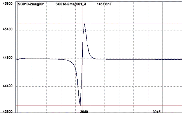
16.5.1.17 A magnetic contact appears as a spike in the data as shown in the Figure 16.9
below which is MC008.
Figure 16.9: Example of identified magnetic contact
16.5.1.18
The results of the magnetometer survey are presented
as a series of summary charts in Appendix 16.7. Each chart shows the location of the sonar
contact and associated magnetic contacts.
A total of 180 magnetic contacts were located.
Interpretation
of the Magnetic Survey Data
16.5.1.19
A magnetometer is an instrument used to measure the
intensity of a magnetic field. Their application in geophysical prospection is
founded on the principle that they can measure and record deviations in the
Earth’s ambient magnetic field brought about by the presence of ferromagnetic
material. The practical application of magnetometers in marine archaeology is
mainly limited to the detection of ferrous objects. Iron has been used in the
construction and fitting of vessels for several millennia. Marine archaeological
remains may include ferrous objects such as anchors, cannons, ordnance and ships fittings.
In this project, this is particularly important as a
cannon was retrieved in 1993 during the airport construction.
16.5.1.20 Research has been carried out into the specific magnetic properties of
archaeological materials (Bevan, 1999). The intensity of the magnetic moment
will vary depending on the size, composition, shape of the object, distance and
angle between the object and the magnetometer. The interpretation of magnetic
data is therefore complex and does not provide absolute precision. It is also
important to note that a magnetic contact creates a magnetic field over an area
rather than a point. A positioning
accuracy of +/- 5 m is therefore appropriate for this survey.
16.5.1.21 Anomaly size is not a definitive factor when ascribing meaning to what
has been recorded. A gun at 10 m may
give a 5 nT anomaly but so
also would a 10,000 ton ship 1,500 m away. Magnetic anomalies can also be
caused by a buried object close to the sonar contact rather than the sonar
contact itself. It is also possible that an object with high ferrous content,
large in size or close to the sea surface may cause anomalies on a number of
adjacent survey lines instead of only one
(Camidge, 2010).
16.5.1.22 The magnetometer survey located a total of 180 magnetic contacts. This
is exceptionally high in comparison to other recent surveys in Hong Kong. It is deduced that this is a result of
previous seabed disturbance from the CMPs and airport construction. The spatial
correlation between the magnetometer contacts and the sonar contacts was
examined to indicate the possible presence of a debris field. Magnetic contacts
located within a 25 m radius of sonar contacts provide a much stronger
indicator of the possible presence of archaeological material than isolated
sonar or magnetometer contacts alone. Shipwreck sites are often characterised
by a field of debris, some of which will be buried and some of which will be
metallic. This clustering of buried and surface contacts provides a rational
selection criterion and a means of prioritising any subsequent survey efforts
effectively. Table 16.4
summarises the locations of the magnetic contacts
relative to sonar contacts and the CMPs.
Table 16.4: Summary
of Magnetic Contact Locations
|
Sonar Contact (SC) ID |
Nos. Magnetic Contacts |
||||
|
|
Total No. (based on closest proximity) |
Within 25m radius of nearest SC |
Outside 25m radius of nearest SC |
||
|
|
Within CMP area |
Outside CMP area |
Within CMP area |
Outside CMP area |
|
|
SC011 |
4 |
0 |
0 |
0 |
4 |
|
SC013 |
13 |
0 |
9 |
0 |
4 |
|
SC014 |
1 |
0 |
1 |
0 |
0 |
|
SC015 |
0 |
0 |
0 |
0 |
0 |
|
SC016 |
0 |
0 |
0 |
0 |
0 |
|
SC017 |
7 |
0 |
3 |
0 |
4 |
|
SC018* |
2 |
0 |
0 |
2 |
0 |
|
SC019* |
7 |
6 |
0 |
1 |
0 |
|
SC020 |
9 |
0 |
3 |
0 |
6 |
|
SC021 |
15 |
0 |
4 |
0 |
11 |
|
SC022* |
24 |
9 |
0 |
11 |
4 |
|
SC023 |
14 |
0 |
10 |
0 |
4 |
|
SC024* |
3 |
2 |
0 |
0 |
1 |
|
SC025* |
8 |
2 |
0 |
6 |
0 |
|
SC026 |
10 |
0 |
5 |
0 |
5 |
|
SC027* |
15 |
2 |
0 |
8 |
5 |
|
SC028 |
3 |
0 |
0 |
0 |
3 |
|
SC029 |
7 |
0 |
7 |
0 |
0 |
|
SC037 |
12 |
0 |
8 |
0 |
4 |
|
SC038 |
7 |
0 |
4 |
0 |
3 |
|
SC039 |
9 |
0 |
0 |
0 |
9 |
|
SC040 |
10 |
0 |
3 |
0 |
7 |
|
Total |
180 |
21 |
57 |
28 |
74 |
*Denotes Sonar Contacts which are located near the boundary of the CMPs
16.5.2 Marine Archaeological
Potential
Contaminated Mud Pit Areas
16.5.2.1 The CMPs are created by extracting the original mud and sand using
dredging and then filling with the contaminated sediments. A sand cap is then
placed over the pit to seal the contaminated sediment. Table 16.5
below presents the depth and thickness of the mud at each
mud pit. The original dredging of the pits is to the top of the alluvial
sediments and removal of all the softer Marine Deposits. It is clear that the
scale of dredging with a minimum of 17.4 m and maximum of 36.5 m required at
each mud pit location would have totally destroyed the marine archaeological
remains, if any, at each of the mud pit locations. There would also have been
significant seabed disturbance around the actual pit during the construction,
filling and subsequent capping process.
16.5.2.2 The 2005 EIA (ERM, 2005) details that CMP I to III were used to dispose
of dredged contaminated mud from December 1992 to November 1997. CMP IVa started operating in 1997 and was full by 2000. The
remaining CMP IV pits are located outside the third runway project boundary. Table 16.5
summarises the properties of the existing CMPs.
Table 16.5: Depth
and Properties of the Existing CMPs
|
Location |
Average Seabed Level (mPD) |
Average Base of Mud (mPD) |
Deepest Base of Mud (mPD) |
Average Mud Thickness (m) |
Maximum Mud Thickness (m) |
|
Pit I |
-5.4 |
-24.4 |
-27.5 |
18.7 |
22.0 |
|
Pit IIA |
-6.0 |
-20.9 |
-26.1 |
15.6 |
20.0 |
|
Pit IIB |
-6.0 |
-23.8 |
-26.0 |
17.7 |
20.0 |
|
Pit IIC |
-6.6 |
-21.8 |
-25.3 |
15.6 |
18.0 |
|
Pit IID |
-7.7 |
-26.6 |
-27.5 |
19.0 |
19.7 |
|
Pit IIIA |
-6.6 |
-21.1 |
-23.7 |
14.5 |
17.0 |
|
Pit IIIB |
-6.2 |
-21.9 |
-23.2 |
16.1 |
17.0 |
|
Pit IIIC |
-5.2 |
-16.5 |
-18.2 |
11.5 |
13.2 |
|
Pit IIID |
-5.6 |
-17.6 |
-25.9 |
12.3 |
20.00 |
|
Pit IVA |
-6.8 |
-36.5 |
-36.6 |
29.4 |
29.7 |
|
CPRC |
-5.8 |
-17.8 |
-17.6 |
11.7 |
2.00 |
16.5.2.3 The seabed at all of these areas is considered to have zero
archaeological potential due to the very extensive previous seabed disturbance;
therefore, there is no concern regarding the potential impact on marine
archaeology. The CMPs cover a total of approx. 4,122,000 m2 within
the MAI study area boundary (out of the total MAI study area of approx.
14,820,000 m2), which is equivalent to approx. 28 %.
16.5.2.4 As shown in Table
16.4,
for the six sonar contacts identified near the edge of the CMPs, a total of 21
magnetic contacts within 25 m radius were found; however, all magnetic contacts
were located within the boundary of the CMPs. These magnetic contacts may be
associated with ‘impurities’ in the materials disposed in the CMPs (e.g. modern
debris) rather than due to the transport of objects into the CMP area (e.g. due
to seabed currents or accidental transport by fish trawling activities) after
they were capped. Given the zero archaeological potential of the CMPs, the
archaeological potential of these magnetic contacts located within the CMP
boundaries is also considered to be low; therefore, it is not proposed to
undertake further investigation on these 21 magnetic contacts.
16.5.2.5 The remaining 72.2 % of the MAI study area has high archaeological
potential based on the historical records.
However this is reduced due to the indirect seabed disturbance associated
with the CMPs. As shown in Table 16.4,
a total of 57 magnetic contacts located within 25 m radius of the sonar contacts
were identified. The major engineering works for the land formation and
subsequent construction of the airport, fuel pipes and power cables have
created additional cumulative negative impact on the seabed. It is highly unlikely that there are any intact
shipwrecks within the study area.
16.5.2.6 However, the possibility remains that there could be a Low Integrity
Shipwrecks (LIS) (OCS Study MMS 2 February, 2004). This category includes ships broken up at
sea, rough weather, and on shoals or other obstructions. The surviving
archaeological record may consist of little more than fragments of the vessel
structure and a scatter of material associated with operation of the vessel or
cargo. LIS shipwrecks may not produce any acoustic image and the images can consist
of little more than a scatter of bottom surface material. The magnetic
signatures associated with LIS sites are ordinarily scatters or clusters of
anomalies that reflect the fragmented nature of structural remains and the
distribution of fastenings, tackle, ordnance, cargo, and other materials.
16.5.2.7 The high number of magnetic contacts located during the magnetometer
survey is consistent with the classification of LIS shipwrecks. This is further confirmed by the retrieval of a cannon during the dredging for the airport. It is therefore concluded that it is possible
that the side scan sonar and magnetic contacts are indicative of scattered
shipwreck remains. Clearly, the significance of the potential impact on features
of potential archaeological interest is dependent on the actual nature of the
identified anomalies. However, it is not possible to determine the actual
nature of the anomalies and, therefore, their archaeological potential on the
basis of geophysical data alone.
16.5.2.8 Definitive classification of the objects can only be achieved with
visual diver inspection. This would ‘ground prove’ the findings of the
geophysical survey and provide an accurate assessment of their archaeological
value.
Magnetic
Contacts with Archaeological Potential
16.5.2.9 There is no exact formula for assessing archaeological potential. As discussed in Section 16.5.1.20 – 16.5.1.21,
there are a complex set of variables that determine the size and type of
magnetic signature that is recorded by the magnetometer. In this case, as the focus for the survey was
the 22 sonar contacts previously located, the location of each magnetic contact
within 25 m range was plotted in relation to each of the sonar contacts. As
shown in Table 16.4,
a total of 78 magnetic contacts were identified within the 25 m radius, of
which there are 57 magnetic contacts located outside the CMP boundaries. Based on the
rationale described in Section 16.5.1.22,
further investigation was conducted on the 57 magnetic contacts and the associated 11 sonar contacts. The result table
and charts of the 57 magnetic contacts are presented in Appendix 16.8. For the remaining
21 magnetic contacts, as explained in Section 16.5.2.4, these are located within the CMP
area and are thus not proposed for further investigation.
16.5.3 Further
Investigation
Visual
Diver Survey
16.5.3.1
An application for Licence to Excavate and Search for
Antiquities under the Antiquities and Monuments Ordinance was made for
conducting visual diver survey of the 57 magnetic contacts and the associated 11 sonar contacts. The
application was submitted on 28 March 2013 and the Licence was issued by the Antiquities Authority on 28 June 2013.
16.5.3.2
The diver survey was completed in two separate phases.
The first phase (for dive targets located outside the Hong Kong International
Airport Approach Area (HKIAAA)) commenced on 5 July 2013 and diving took place
every day until 14 July 2013. The second
phase (for dive targets located within the HKIAAA) was undertaken on 3 August
2013, after the HKIAAA entry permit from the Marine Department was issued.
16.5.3.3
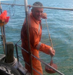
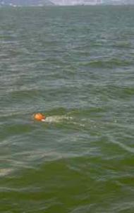
A team of four divers plus Sarah Heaver as the
licensed marine archaeologist completed the survey. A Global Positioning System
(GPS) was used to control the location of the dive support boat. The boat was
positioned above each target and a shot weight was placed on the seabed marked
by a buoy on the surface (see Photo 16.1 and Photo 16.2). The drop position was checked against the
target position using the GPS. The boat was then anchored to ensure the diver’s
easy access to the seabed marker and also provide surface cover for the divers
at all times.
|
Photo 16.1: Launching the sinker |
Photo 16.2: |
|||
|
|
|
|||
|
Photo 16.3: Control Centre for Communication with the
diver |
Photo
16.4: Surface
supplied air helmet |
|||
|
|
|
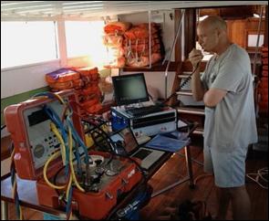
16.5.3.4
The diver was equipped with a hand held video camera and
stills camera to record the unknown objects and associated seabed
features. The video had a remote TV
monitor in the boat’s wheelhouse, which displayed the video footage in real
time (Photo 16.3). This
facilitated managing the diver from the surface via the through water
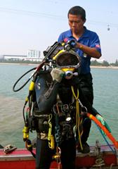
communications. Surface supplied air was used at all times (Photo 16.4).
16.5.3.5
All diving operations followed the Code of Practice –
Safety and Health at Work for Industrial Diving (1998), as published by the
Occupational Safety and Health Branch of the Hong Kong Labour Department. All
diving operations also followed the requirements of the UK Health and Safety
Executive Diving at Work Regulations (1997) and the Commercial diving projects
inland/inshore: Diving at Work Regulations (1997), Approved Code of Practice.
16.5.3.6
On completion of the diver survey, the results were
documented with supporting video captures and photographs.
Dive
Survey Findings
16.5.3.7
Across the whole study area
the seabed was soft silty mud. This created a very difficult working
environment for the divers as the through water visibility was very restricted
and at times zero. Strong tidal currents affect the study area, which at times
hindered the progress of the diver survey. The poor water quality associated
with the prevailing high suspended solids also resulted in very low quality
photographs, irrespective of weather conditions, though the water quality was
further degraded after the impact of Typhoon Jebi
which passed near the study area.
16.5.3.8
From the underwater video
footage and samples retrieved, each one of the sonar and magnetic contacts were
quickly and easily identified by the marine archaeologist as modern debris,
probably associated with original construction of the airport in the 1990s.
This modern debris included metal bars, wires, poles, pipes, concrete blocks
and various other construction wastes. A table presenting the detailed results
of each of the sonar and magnetic contacts is presented in Appendix 16.9.
16.5.3.9 Every sonar and magnetic contact was located during the diver survey and
identified as modern debris. No marine archaeological remains were positively
identified during the seabed survey.
Based on these findings, no further action or mitigation is required.
16.5.4 Terrestrial
Archaeology
16.5.4.1 The baseline terrestrial archaeology review has identified two sites
(the Ha Law Wan site of archaeological interest and the Sha Chau site of archaeological interest) which are located within the project boundary on the existing airport
island / Sha Chau Island. Aside from these two sites,
no other sites of archaeological interest or sites of archaeological potential
are anticipated within the project area.
16.5.4.2 Within the
existing airport island, road improvement activities are proposed at the
southern cargo roads to the northwest of Scenic Hill. This includes some minor
re-alignment works for existing roads as well as construction of new elevated
roads along the existing Chun Wan Road and Chun Yue Road, and associated
utility diversions. The nearest construction activity is at the existing roads
immediately adjacent to the boundary of the Ha Law Wan site as
shown
in Drawing
No MCL/P132/EIA/16-005. Based on the initial scheme design for the road
works, there will be no encroachment into the boundary of the site of
archaeological interest during construction or operation phase. Indirect
impacts due to bored piling activities for construction of the elevated roads
are expected to be insignificant given the very
localised nature of the piling works and there will be a buffer distance of
approx. 25 m between the viaduct piers and the boundary of the site of
archaeological interest. Based on this assessment, no impact to this site of
archaeological interest is anticipated during construction phase.
16.5.4.3 During
operation phase, both the re-aligned roads and the new elevated roads are
expected to be compatible with the visual context of the existing airport
landscape at HKIA, and there will be no reduction of the existing urban park
landscape at the site of archaeological interest, or the existing hillside
landscape on Scenic Hill. Operation of the road improvements are thus not
expected to result in any significant visual / amenity impacts to the site of
archaeological interest.
16.5.4.4 The Sha Chau site of archaeological
interest lies above the drilling
activities for the submarine aviation fuel pipelines. This submarine pipelines
will be constructed using the horizontal directional drilling (HDD) method,
which involves drilling through the sub-sea bedrock before surfacing on Sheung
Sha Chau Island (where the AFRF is located). With
this construction method, there
will be no direct disturbance to the site of archaeological interest on Sha Chau Island.
Potential indirect disturbance due to vibration is expected to be insignificant
given that each drillhole will be less than 1 m in
diameter and the drilling depth will be largely about 50 m below the seabed.
Thus no impact is anticipated due to the construction and operation of the
submarine aviation fuel pipelines.
16.5.4.5 During
construction of the submarine 11 kV cable diversion, temporary power supply
will need to be provided to the existing facilities at the islands within the Sha Chau and Lung Kwu Chau Marine
Park. The power supply to Sha Chau is critical to the operation of HKIA since there
is a CAD radar station, a Hong Kong Observatory (HKO) station, and the AFRF
located at Sha Chau. Any disruption to the operation
of these facilities at Sha Chau would thus have
negative consequences on aviation control and emergency fuel supply operations
at HKIA.
16.5.4.6
The proposed arrangement for the temporary power supply involves
installation of a temporary generator unit and fuel tank on the existing
concrete jetty at Sha Chau Island (see Drawing No.
MCL/P132/EIA/16-006). The generator will be housed in a shipping
container type housing and the fuel tank will be installed adjacent to the
generator unit, within a storage bund. An 11 kV power cable will be connected
from the generator unit to the existing CLP transformer / switchroom
at the CAD station on Sha Chau Island. The 11 kV
cable will be installed within a covered concrete trough placed along the
concrete jetty and existing concrete footpath running up to the CAD station.
All installation works and equipment associated with this temporary power
supply provision would be of a temporary nature (for a few months only) and
mounted only on existing concrete jetty structure and pavements. No excavation
works will be permitted on Sha Chau Island.
16.5.4.7 Based on this
arrangement, the potential impact to the Sha Chau
site of archaeological interest during construction phase would be
insignificant, and there would be no impact during operation phase.
16.5.5 Built Heritage
16.5.5.1 There will be no direct impact to any built heritage during construction
and operation phase, as no built heritage resources are located within the
project boundary.
16.5.5.2 At the airport island site, indirect impacts due to vibration, noise or
visual disturbance are unlikely given that the nearest built heritage is
located at least 500 m away from the nearest works area for the project, and is
separated by a large body / channel of water which acts as a physical barrier
between the built heritage sites and the project boundary. Given the large
separation distance and the physical barrier, indirect impacts to these built
heritage sites are not anticipated as a result of project activities.
16.5.5.3 At the Sha Chau site, the Tin Hau Temple is located approx. 400 m away from where the
temporary power supply will be located, and its direct line of sight to the project
activities is shielded by the island’s terrain. Similarly, the works area for
project activities at Sheung Sha
Chau Island for the daylighting of the submarine aviation fuel pipeline is
located more than 500 m away and is separated by a
large body / channel of water which acts as a physical barrier between the
built heritage site and the project boundary. Based on these considerations, no vibration,
noise or visual disturbance to this built heritage feature is anticipated as a result of project activities.
16.6
Mitigation
Measures
16.6.1 Marine
Archaeology
16.6.1.1
The marine archaeological investigation established
that no resources of marine archaeological value are located with the MAI study
area and hence no marine archaeological impacts are expected. No mitigation measures are required.
16.6.2
Terrestrial
Archaeology
16.6.2.1 The findings from the terrestrial archaeological assessment showed that
no sites of archaeological interest or potential archaeological deposits will
be impacted by the project. Hence no mitigation measures are required.
16.6.3 Built Heritage
16.6.3.1 The findings from the built heritage assessment showed that no built
heritage will be impacted by the project. Hence no mitigation measures are
required.
16.7 Residual Impacts
16.7.1
Marine Archaeology
16.7.1.1 There will be no residual impacts to underwater cultural heritage
resources within the study area due to the project.
16.7.2
Terrestrial Archaeology
16.7.2.1 There will be no residual impacts on terrestrial sites of archaeological
interest or built heritage during construction and operation phase.
16.7.3 Built Heritage
16.7.3.1 There will be no residual impacts on terrestrial sites of archaeological
interest or built heritage during construction and operation phase.
16.8 Environmental Monitoring and Audit
16.8.1.1 No environmental monitoring and audit is required for marine archaeology
or terrestrial cultural heritage.
16.9
References
1.
AMO (2012)
List of the Historic Buildings in Building Assessment (as of 17 December 2012)
2.
AMO (2012)
List of Sites of Archaeological Interest in Hong Kong (as at November 2012)
3.
Camidge, K., Holt,
P., Johns, C., Randall, L., & Schmidt, A. 2009. Developing Magnetometer
Techniques to Identify Submerged Archaeological Sites. Theoretical Study Report
No: 2010R012. Historic Environment, Environment, Planning & Economy
Cornwall Council
4.
Cortesão, A. 1944.
The Suma Oriental of Tomé Pires and the Book of
Francisco Rodrigues. London. Hakluyt Society.
5.
EGS (Asia)
Limited, 2013. Hong Kong International
Airport. Airport Authority Contract P548. Marine Site Investigations.
Hydrographic, Marine Geophysical and Oceanographic Surveys. Preliminary Report.
HK Job Number HK229012.
6.
Empson, H. 1992.
Mapping Hong Kong. Hong Kong. The Government Printer.
7.
ERM, 2005.
AEIR -089/2005. New Contaminated Mud Pit
Facility at Airport East/ East Sha Chau Area. EIA.
8.
Fyfe, J.A.
& Shaw, R. 1997. The Offshore Geology of Hong Kong. Hong Kong Geological
Survey Memoir. Geotechnical Engineering Office, Hong Kong.
9.
Lui Yuen-chung, A. 1990. Forts and Pirates - a History of Hong Kong.
Hong Kong History Society.
10.
Meacham,
W. 1994. Archaeological Investigations on Chek Lap Kok Island. Journal Monograph IV. Hong Kong Archaeological
Society.
11.
Murray,
D.H. 1987. Pirates of the South China Coast 1790-1810. Stanford University
Press.
12.
Neumann,
K. F. 1831, History of the Pirates who Infested the China Seas from 1807-1810
by Yung-lun Yüan. Printed
for the Oriental Translation Fund.
13.
OCS Study
MMS 2004-005. February 2004. Archaeological Damage from Offshore Dredging:
Recommendations for Pre-Operational Surveys and Mitigation during dredging to
avoid adverse impacts. Prepared for: U.S. department of the interior minerals
management service. Under Contract Number No. 01-02-CT-85139
14.
Ove Arup &
Partners Hong Kong Ltd (2009) HZMB – HKBCF & HKLR: Environmental Impact
Assessment Report, July 2009
15.
Schofield, W. 1983. The
Islands around Hong Kong. Journal of the
Royal Asiatic Society Hong Kong. Volume
23.
16.
Siu,
A.K.1978. Distribution of Forts and
Guard Stations on Lantau Island during the late Ch'ing period. Journal of the Royal Asiatic Society Hong Kong. Volume 23.
17.
Siu, A.K. 1979. A study on the Ch’ing forts on Lantau Island
(from Chinese Sources). Vol. 19.
18.
Siu, A.K. 1982. More About Tung Chung Fort.
Journal of the Royal Asiatic Society Hong Kong. Volume 23.