|
Consultancy Ref.: AFCD/FIS/02/19 Consultancy Service for Environmental Impact Assessment Study for Designation of New Fish Culture Zones Environmental Impact Assessment (EIA) Report for Establishment of Fish Culture Zone at Po Toi (Southeast)
November 2022
|
8. Cultural
Heritage
8.1
Introduction
This Section presents the cultural heritage impact assessment (CHIA) associated with the construction of the proposed Project. In accordance with Clause 3.4.8 of the Study Brief No. ESB-327/2019, a Marine Archaeological Investigation (MAI) including impact assessment was undertaken by the qualified marine archaeologist (Dr. William Jeffery) and the findings of the MAI are presented herein.
8.2
Legislative Requirements and
Evaluation Criteria
The following legislations/standards/guidelines/requirements is applicable to the assessment of archaeological and historic resources in Hong Kong.
§ Environmental Impact Assessment Ordinance (Cap. 499) and the associated Technical Memorandum on the EIA Process (EIAO-TM);
§ Antiquities and Monuments Ordinance (Cap. 53) (AM Ordinance);
§ Hong Kong Planning Standards and Guidelines; and
§ Requirements for Marine Archaeological Investigation (MAI) (Appendix G of the EIA Study Brief).
8.2.1 Environmental Impact Assessment Ordinance (Cap 499)
Annex 10 of the EIAO-TM outlines the criteria for assessment of impact on sites of cultural heritage. The general presumption is in favour of the protection and conservation of all sites of cultural heritage. In addition, adverse impacts on sites of cultural heritage shall be kept to the absolute minimum.
Annex 19 of the EIAO-TM outlines the approaches required in investigating and assessing the impacts on sites of cultural heritage. There is no quantitative standard in deciding the relative importance of these sites, but in general, sites of unique archaeological, historical or architectural value will be considered as highly significant. Preservation in totality is preferred. If, due to site constraints and other factors, only preservation in part is possible, this must be fully justified with alternative proposals or layout designs, which confirm the impracticability of total preservation.
8.2.2 Antiquities and Monuments Ordinance (Cap 53)
The Antiquities and Monuments Ordinance (Cap. 53) (AM Ordinance) provides statutory protection against the threat of development on Declared Monuments to enable their preservation for posterity. The AM Ordinance also establishes the statutory procedures to be followed in making such a declaration.
Any person who discovers an antiquity, or supposed antiquity, is required to report the discovery to the Antiquities Authority.
8.2.3 Hong Kong
Planning Standards and Guidelines (HKPSG)
The Chapter 10, Conservation, of the HKPSG provides general guidelines and measures for the conservation of historical buildings, sites of archaeological interest and other antiquities.
8.2.4 Requirements for Marine Archaeological Investigation (MAI)
Requirements for MAI provided in Appendix G of the Study Brief details the standard practice, procedures and methodology which must be undertaken in determining marine archaeological baseline and potential, presence of archaeological artefacts, evaluating the potential impact and establishing suitable mitigation measures.
8.3 Assessment
Methodology
8.3.1 Introduction
The CHIA follows the criteria and guidelines in Annexes 10 and 19 of the EIAO-TM. It also follows the Requirements for MAI as stated in Appendix G of the EIA Study Brief. It should be noted that the Project is marine-based and thus potential impacts on built heritage and terrestrial archaeological resources are not anticipated. Findings of the MAI of this Project are presented in the following sections.
8.3.2 Assessment
Area
As the construction works of the proposed Po Toi (Southeast) Fish Culture Zone (FCZ), would mainly be the assembly and anchorage of fish rafts / cages that will be carried out by the fish farmers who obtain marine fish culture licences in this new FCZ which is limited to marine area, no built heritage impact assessment and terrestrial archaeological impact assessment will be conducted for the Cultural Heritage Impact Assessment (CHIA). Therefore, the CHIA will only cover the Marine Archaeological Investigation (MAI).
The Assessment Area for the MAI includes an area to be affected by the marine works associated with the anchoring system of fish rafts/cages as shown in the Project site location in Figure 8.1.
8.3.3 Baseline
Review
A baseline review was conducted to collate existing information to identify the archaeological potential and their likely character, extent, quality and value. The baseline review will focus on known sources including:
a) Civil Engineering and Development Department, Geotechnical Engineering Office – The Department holds extensive seabed survey data collected from previous geological research;
b) Marine Department, Hydrographic Office – the Department holds a substantial achieve of hydrographic data and charts;
c) The Royal Naval Hydrographic Department in the UK – the Department maintains an archive of all survey data collected by naval hydrographers;
d) Relevant Government departments such as Antiquities and Monuments Office, Environmental Protection Department etc. to obtain information on dredging history on the Project site location; and
e) Internet and libraries sources of relevant studies.
The findings will provide historical records and more detailed geological analysis of submarine features which may have been subsequently masked by more recent sediment deposits and accumulated debris.
8.3.4 Marine
Geophysical Survey
A marine geophysical survey of the proposed Po Toi (Southeast) FCZ was conducted and deployed high resolution boomer, side scan sonar, an echo sounder and high resolution multi beam sonar. The multi-beam data was presented as processed digital terrain models to facilitate the archaeological analysis. The data received from the survey were analysed in detail to provide:
§ Exact definition of the areas of greatest archaeological potential;
§ Assessment of the depth and nature of the seabed sediments to define which areas consist of suitable material to bury and preserve archaeological material;
§ Detailed examination of survey records to map anomalies in and on the seabed which may be archaeological material; and
§ Detailed examination of the multi beam sonar data to assess the archaeological potential of the sonar contact.
8.3.5 Establishing
Marine Archaeological Potential
The data examined during baseline review and marine geophysical survey data review were analysed to provide an indication of the likely character and extent of archaeological resources within the assessment area. The results are presented in below sections.
8.3.6 Further
Archaeological Actions (Provisional)
Subject to the results of establishing archaeological potential, accepted marine archaeological practices could be recommended to acquire more detailed data on areas with archaeological potential that may potentially be impacted by the Project site at Po Toi (Southeast). These may include further detailed marine geophysical surveys of potential areas, including Remote Operated Vehicle, visual diver survey, or employing a watching brief. If it is considered necessary, the detailed plan and scope will be agreed with AFCD, EPD and Antiquities and Monuments Office (AMO).
8.3.7 Impact
Assessment and Recommendations
Based on the findings and analysis of the baseline conditions and results of the evaluation of the marine archaeological potential, an impact assessment was conducted to evaluate the potential marine impacts of the Project on marine archaeological resources / sites, and recommend necessary marine archaeological actions or mitigation measures.
8.4 Marine
Archaeological Review
8.4.1 Baseline
Review
8.4.1.1
Review of Historical Documents
The Assessment Area is located at the waters off southeast Po Toi (See Figure 8.1). The Project site at Po Toi (Southeast) is approximately 100 hectares (850 - 1500m long and 850m wide) in size. The closest Tai Wan Site of Archaeological Interest, Po Toi (Tai Wan SAI, Po Toi), is located behind Tai Wan Bay over 2 km at west of the Assessment Area, where prehistoric sherds were found. Rock Carvings which can be dated back to the Bronze Age are found on the Po Toi Island, are now Declared Monuments (Peacock, 1985).
The name “Po Toi Shan” (蒲胎山) first appeared in the <Zhenghe Navigation Map> (鄭和航海圖) (See Figure 8.2) which was drawn up in 1425, and published in the Ming dynasty military treatise Wubei Zhi (武備志). In 1950s to 1960s, inhabitants of Po Toi mainly resided in two villages, namely Chang Shek Pai (長石排) and Shan Liu (山寮). Most of the villagers carried the surnames of Yu (余), Ho (何), Wan (溫), Pang (彭) and Chan (陳) and subsisted on farming, fishing and the harvesting of sea-weed. The population has fallen dramatically over the past few decades, as young generation tend to move away and seek employment opportunities in the city.
In March 2015, a cannon was recorded by the Hong Kong Underwater Archaeological Association at the waters approximately 100m off south of Po Toi during their regular diving activities in March 2015 at a water depth of approximately 11m. It was also reported that two anchors and a section of iron chain were also identified about 20m from the cannon at a water depth of approximately 15m.([85]) Whilst their archaeological potential is yet to be checked, these items are over 1.5km from the Project site and will not be affected by the Project.
8.4.1.2
Geological Conditions
The solid geology of the Assessment Area consists of Hang Hau Formation with shallow marine sediments comprising beach sand, intertidal (mud and sand) and estuarine deposits (mud, clayey silt and sand). Onshore geology in the vicinity of Po Toi (Southeast) FCZ belongs Po Toi Granite comprising megacrystic coarse-grained to equigranular medium- and fine-grained biotite granite (EGS, 2021).
8.4.1.3
Review of Charts
Two charts, one from 1845-1849 titled “China Sheet II Eastern Coast from Hong Kong to Chelang Point” (see Chart 8.1) shows Po Toi (called Poo-toy on the chart) with no other detail surrounding the islands: and USA Chart no. 2503, “China, South Coast: Hong Kong to Mirs Bay” compiled from British surveys until 1906 and published in 1928, shows greater detail around the islands, but no shipwrecks of other archaeological material.
Chart 8.1 “China Sheet II Eastern Coast from Hong Kong to Chelang Point” Showing Po Toi
![]()

8.4.1.4
United Kingdom Hydrographic Office
‘Wreck’ Files
The United Kingdom Hydrographic Office in Taunton maintains a database of known shipwrecks / undefined sites in the HKSAR. This is the same data held by the Hong Kong Marine Department, Hydrographic Office. The review showed that no wrecks were found to be within the MAI Assessment Area.
8.4.1.5
Summary of Marine Archaeological
Potential
Based on the historical review, the human activities have occurred since the Bronze Age around the area. Evidence shows that fishing and maritime transport associated with the old villages has been the major maritime activities at the adjacent area. No shipwrecks of marine archaeological potential identified from the Charts and the Wreck Databases, the waters of the Assessment Area may have marine archaeological potential.
8.4.2 Marine
Geophysical Survey Result
A marine geophysical survey as part of the site investigations of the Project was conducted on 19th and 29th March 2021 to study the seabed features and to locate anomalous features in the surveyed area. The survey covered the areas to be affected by marine works associated with the anchoring system of fish rafts. The survey findings were processed by the geophysicists and reviewed by the qualified marine archaeologist, Dr William Jeffery, and cultural heritage specialist, Ms Peggy Wong. Figure 8.1 shows the marine geophysical survey coverage. The survey track plots are shown in Appendix 8A. Details of survey types with objectives and survey spacing are shown in Table 8.1 and the equipment list is shown in Table 8.2.
The seabed is primarily covered with fine sediment mainly consist of silty. Isolated to scattered pockmarks, small areas of disturbed seabed with possible dumped materials and several seabed scars are observed on the seafloor. Rock outcrop areas are located at the southwestern margin of the survey site while a small area of coarse sediments with poorly developed megaripples located in the west of the survey site (see Figure 8.3, Figure 8.4 and Figure 8.5).
Review of the survey findings identified 85 sonar contacts (D-SC001 to D-SC085). They are located at a range of water depth from 33.1m to 38m and their dimensions are shown in Table 8.3. Most of the sonar contacts are interpreted as debris, seventeen of sonar contacts are possibly gravel patches (D-SC002, D-SC003, D-SC012, D-SC014, D-SC015, D-SC026, D-SC029, D-SC031, D-SC033, D-SC046, D-SC049, D-SC053, D-SC059, D-SC061, D-SC064, D-SC071 and D-SC074), five are possibly tires (D-SC015, D-SC077, D-SC079, D-SC081 and D-SC084) and four are linear debris (D-SC010, D-SC017, D-SC018 and D-SC082). Due to their random placement, the diminished intensity of the sonar contact, small in size, irregular shape, and lack of a shadow to indicate they have some elevation, they have been interpreted as natural material and of no marine archaeological potential. From the survey, D-SC005, D-SC009, D-SC013 & D-SC055 have comparatively strong signal strength and some regular shape, Figure 8.6, Figure 8.7, Figure 8.8 and Figure 8.9 show their SSS rectified images respectively, and are possibly of marine archaeology potential. Their locations are shown in Figure 8.1 and the sonar contact images are illustrated in Appendix 8B. According to Annex 10 of EIAO-TM, the general presumption is in favour of the protection and conservation of all sites of cultural heritage. The potential direct impact on these four sonar contacts (D-SC005, D-SC009, D-SC013, and D-SC055) that may have marine archaeological potential will be avoided by isolating them with a 20 m radius buffer zone from any tug boat anchoring and anchoring of the fish rafts/cages. Given there is no direct impact to the sonar contacts within Project site that may have marine archaeological potential, it is not necessary to conduct magnetic survey or diver survey to verify the archaeological significance of the Project site that may be of marine archaeological potential.
No sub-bottom anomalies of marine archaeology potential were observed in the Assessment Area.
Table 8.1 Survey Types with Objectives and Survey Spacing
|
Survey Type |
Objective |
Survey Spacing |
|
Multi-beam echo sounding (MBES) |
To provide detailed seabed level variations |
50m, infill lines in shallow areas |
|
Single beam echo sounding (SBES) |
For cross check of MBES data |
50m, infill lines in shallow areas |
|
Side scan sonar (SSS) |
To locate anomalous features and map sediment types on the seabed |
50m, infill lines along the coast |
|
Seismic sub-bottom profiling (SBP) |
To identify sub-bottom features and stratigraphy |
50m x 200m grid |
|
Type |
Equipment |
|
Survey Vessel |
Class II licenced survey vessel Wing Hung 2 |
|
Horizontal positioning |
C-Nav Globally Corrected Global Positioning System (GcGPS) Model 3050M |
|
Single beam echo sounding |
Knudsen 320M dual frequency Single-beam Echo Sounder |
|
TSS 320B Motion Sensor |
|
|
Multi-beam echo sounding |
R2Sonic SONIC2024 Multi-beam Echo Sounder |
|
Side scan sonar |
EdgeTech 4200 (100kHz & 400kHz) |
|
Seismic sub-bottom profile |
C-Boom Low Voltage high-resolution Boomer system |
|
C-Phone hydrophone system |
|
|
Software |
C-Nav computerized navigation suite |
|
C-View digital recording and processing system |
|
|
|
3-D seismic interpretation environment |
|
Others |
A/C generators, computers and bar check equipment |
Table 8.3 Sonar contacts Summary Table
|
Contact number |
Latitude Longitude |
Easting Northing |
Water depth (m) |
Dimensions (m) |
Description |
|
D-SC001 |
22° 9.486' N 114° 16.946' E |
847156.1E 802186.8N |
35.4 |
0.9x0.9xnmh |
Debris |
|
D-SC002 |
22° 9.487' N 114° 16.949' E |
847162.1E 802188.2N |
35.4 |
1.2x0.9xnmh |
Possible debris / Gravel patch |
|
D-SC003 |
22° 9.489' N 114° 16.957' E |
847174.9E 802192.2N |
35.4 |
1x0.9xnmh |
Possible debris / Gravel patch |
|
D-SC004 |
22° 9.512' N 114° 16.943' E |
847151.2E 802235.2N |
35.4 |
1.2x0.9xnmh |
Debris |
|
D-SC005 |
22° 9.530' N 114° 16.978' E |
847210.7E 802267.4N |
35.3 |
2.0x1.0x<0.5 |
Debris |
|
D-SC006 |
22° 9.533' N 114° 16.980' E |
847215.3E 802273.0N |
35.3 |
1.2x0.8xnmh |
Debris |
|
D-SC007 |
22° 9.534' N 114° 16.905' E |
847085.9E 802274.2N |
35.3 |
1.2x0.9xnmh |
Debris |
|
D-SC008 |
22° 9.541' N 114° 16.915' E |
847102.4E 802287.3N |
35.4 |
0.9x0.8xnmh |
Debris |
|
D-SC009 |
22° 9.551' N 114° 16.928' E |
847125.7E 802306.2N |
35.4 |
1.3x1.2xnmh |
Debris |
|
D-SC010 |
22° 9.661' N 114° 16.720' E |
846767.6E 802508.3N |
35.9 |
190x<0.5xnmh |
Linear debris |
|
D-SC011 |
22° 9.671' N 114° 16.707' E |
846744.5E 802527.8N |
36.1 |
1.2x0.7xnmh |
Debris |
|
D-SC012 |
22° 9.673' N 114° 16.806' E |
846914.7E 802531.5N |
35.4 |
1.1x0.8xnmh |
Possible debris / Gravel patch |
|
D-SC013 |
22° 9.684' N 114° 17.012' E |
847269.9E 802552.4N |
35.1 |
1.3x0.8xnmh |
Debris |
|
D-SC014 |
22° 9.693' N 114° 16.787' E |
846883.0E 802568.4N |
35.6 |
1.0x0.8xnmh |
Possible debris / Gravel patch |
|
D-SC015 |
22° 9.697' N 114° 16.833' E |
846960.8E 802575.8N |
35.3 |
1.7x1.2xnmh |
Possible Tire / Debris |
|
D-SC016 |
22° 9.697' N 114° 16.798' E |
846901.9E 802576.3N |
35.5 |
1.7x0.7xnmh |
Debris |
|
D-SC017 |
22° 9.701' N 114° 16.632' E |
846616.4E 802582.0N |
36.7 |
60x<0.5xnmh |
Linear debris |
|
D-SC018 |
22° 9.706' N 114° 16.596' E |
846554.5E 802591.2N |
38 |
40x<0.5xnmh |
Linear debris |
|
D-SC019 |
22° 9.719' N 114° 16.841' E |
846974.8E 802615.9N |
35.4 |
1.2x0.9xnmh |
Debris |
|
D-SC020 |
22° 9.731' N 114° 16.719' E |
846765.5E 802637.6N |
36.4 |
1.7x1.5xnmh |
Debris |
|
D-SC021 |
22° 9.731' N 114° 16.954' E |
847169.8E 802638.1N |
35.2 |
1.0x0.7xnmh |
Debris |
|
D-SC022 |
22° 9.732' N 114° 16.959' E |
847178.8E 802641.0N |
35.2 |
1.1x0.8xnmh |
Debris |
|
D-SC023 |
22° 9.743' N 114° 16.647' E |
846641.4E 802660.4N |
37.3 |
0.9x0.8x<0.5 |
Debris |
|
D-SC024 |
22° 9.743' N 114° 16.907' E |
847088.1E 802660.7N |
35.3 |
1.3x0.8xnmh |
Debris |
|
D-SC025 |
22° 9.752' N 114° 16.998' E |
847244.3E 802677.0N |
35.1 |
1.4x0.6xnmh |
Debris |
|
D-SC026 |
22° 9.753' N 114° 16.778' E |
846867.6E 802679.3N |
35.9 |
1x0.6xnmh |
Possible debris / Gravel patch |
|
D-SC027 |
22° 9.754' N 114° 16.922' E |
847114.7E 802681.8N |
35.1 |
0.8x0.8xnmh |
Debris |
|
D-SC028 |
22° 9.762' N 114° 16.784' E |
846877.1E 802695.7N |
35.9 |
1.9x0.8xnmh |
Debris |
|
D-SC029 |
22° 9.762' N 114° 16.975' E |
847205.9E 802696.1N |
35.1 |
1.2x0.8xnmh |
Possible debris / Gravel patch |
|
D-SC030 |
22° 9.771' N 114° 16.974' E |
847203.2E 802712.7N |
35.1 |
1.4x0.9xnmh |
Debris |
|
D-SC031 |
22° 9.782' N 114° 16.942' E |
847148.1E 802732.5N |
35.2 |
1.3x1.0xnmh |
Possible debris / Gravel patch |
|
D-SC032 |
22° 9.797' N 114° 16.891' E |
847062.0E 802759.5N |
35.2 |
1.2x0.8xnmh |
Debris |
|
D-SC033 |
22° 9.800' N 114° 16.665' E |
846673.0E 802764.9N |
36.7 |
1.0x0.7xnmh |
Possible debris / Gravel patch |
|
D-SC034 |
22° 9.806' N 114° 16.974' E |
847204.7E 802777.0N |
35 |
1.6x1.2xnmh |
Debris |
|
D-SC035 |
22° 9.813' N 114° 16.997' E |
847243.7E 802790.2N |
34.9 |
1.5x0.8xnmh |
Debris |
|
D-SC036 |
22° 9.816' N 114° 16.786' E |
846880.3E 802795.7N |
35.8 |
1.0x0.7xnmh |
Debris |
|
D-SC037 |
22° 9.818' N 114° 16.990' E |
847231.3E 802798.7N |
34.9 |
1.2x0.8xnmh |
Debris |
|
D-SC038 |
22° 9.823' N 114° 16.866' E |
847018.4E 802807.6N |
35.3 |
1.0x0.7xnmh |
Debris |
|
D-SC039 |
22° 9.823' N 114° 17.025' E |
847291.5E 802809.1N |
34.9 |
1.3x1.2xnmh |
Debris |
|
D-SC040 |
22° 9.824' N 114° 16.792' E |
846891.0E 802809.7N |
35.8 |
1.6x1.1xnmh |
Debris |
|
D-SC041 |
22° 9.824' N 114° 16.866' E |
847017.4E 802811.1N |
35.3 |
1.2x1.2xnmh |
Debris |
|
D-SC042 |
22° 9.829' N 114° 16.877' E |
847036.8E 802819.9N |
35.3 |
0.9x0.7xnmh |
Debris |
|
D-SC043 |
22° 9.830' N 114° 17.020' E |
847282.8E 802820.6N |
35 |
0.9x0.7xnmh |
Debris |
|
D-SC044 |
22° 9.837' N 114° 17.009' E |
847264.8E 802834.5N |
35 |
1x0.7xnmh |
Debris |
|
D-SC045 |
22° 9.838' N 114° 16.793' E |
846892.1E 802836.5N |
35.9 |
1.4x0.7xnmh |
Debris |
|
D-SC046 |
22° 9.840' N 114° 16.841' E |
846975.5E 802838.8N |
35.5 |
1.2x0.8xnmh |
Possible debris / Gravel patch |
|
D-SC047 |
22° 9.860' N 114° 16.802' E |
846908.8E 802876.3N |
35.6 |
1.2x0.7xnmh |
Debris |
|
D-SC048 |
22° 9.861' N 114° 16.929' E |
847126.0E 802879.3N |
35 |
1.0x0.5x<0.5 |
Debris |
|
D-SC049 |
22° 9.869' N 114° 16.908' E |
847090.5E 802893.7N |
35.1 |
0.8x0.5xnmh |
Possible debris / Gravel patch |
|
D-SC050 |
22° 9.872' N 114° 16.970' E |
847196.7E 802898.8N |
34.9 |
0.6x0.6xnmh |
Debris |
|
D-SC051 |
22° 9.894' N 114° 16.985' E |
847222.4E 802939.5N |
35 |
1.1x1.0xnmh |
Debris |
|
D-SC052 |
22° 9.900' N 114° 16.813' E |
846927.1E 802949.9N |
35.5 |
1.5x0.9xnmh |
Debris |
|
D-SC053 |
22° 9.908' N 114° 16.828' E |
846952.9E 802965.0N |
35.3 |
1.1x0.8xxnmh |
Possible debris / Gravel patch |
|
D-SC054 |
22° 9.927' N 114° 16.843' E |
846977.9E 802999.6N |
35.2 |
1.8x0.8xnmh |
Debris |
|
D-SC055 |
22° 9.928' N 114° 16.801' E |
846905.5E 803002.2N |
35.3 |
1.8x1x<0.5 |
Debris |
|
D-SC056 |
22° 9.933' N 114° 16.879' E |
847040.4E 803011.6N |
35.1 |
1.5x0.9xnmh |
Debris |
|
D-SC057 |
22° 9.937' N 114° 16.694' E |
846722.3E 803018.3N |
35.6 |
1.4x1.1x<0.5 |
Debris |
|
D-SC058 |
22° 9.940' N 114° 16.883' E |
847047.5E 803023.8N |
35 |
0.8x0.7x<0.5 |
Debris |
|
D-SC059 |
22° 9.942' N 114° 16.889' E |
847057.5E 803028.3N |
35 |
1.2x0.8xnmh |
Possible debris / Gravel patch |
|
D-SC060 |
22° 9.943' N 114° 16.738' E |
846798.2E 803030.2N |
35.5 |
1.3x1.0xnmh |
Debris |
|
D-SC061 |
22° 9.962' N 114° 16.687' E |
846710.5E 803064.1N |
35.4 |
1.5x1xnmh |
Possible debris / Gravel patch |
|
D-SC062 |
22° 9.963' N 114° 16.997' E |
847242.7E 803067.3N |
34.9 |
2.5x1.8x<0.5 |
Debris |
|
D-SC063 |
22° 9.966' N 114° 16.707' E |
846744.2E 803071.5N |
35.4 |
1.4x0.8xnmh |
Debris |
|
D-SC064 |
22° 9.966' N 114° 17.011' E |
847267.7E 803072.1N |
34.9 |
1.4x0.8xnmh |
Possible debris / Gravel patch |
|
D-SC065 |
22° 9.998' N 114° 16.814' E |
846928.2E 803130.8N |
35.1 |
1.1x0.6x<0.5 |
Debris |
|
D-SC066 |
22° 10.000' N 114° 16.620' E |
846594.6E 803134.5N |
34.8 |
3.2x1.4x<0.5 |
Debris |
|
D-SC067 |
22° 10.020' N 114° 16.820' E |
846939.4E 803171.5N |
35 |
1.2x0.6xnmh |
Debris |
|
D-SC068 |
22° 10.036' N 114° 16.582' E |
846529.3E 803202.0N |
34.1 |
1.3x1.3x<0.5 |
Debris |
|
D-SC069 |
22° 10.039' N 114° 16.582' E |
846529.8E 803206.9N |
34.2 |
1.3x0.9x<0.5 |
Debris |
|
D-SC070 |
22° 10.111' N 114° 16.898' E |
847072.5E 803340.4N |
34.6 |
1.5x0.8x<0.5 |
Debris |
|
D-SC071 |
22° 10.135' N 114° 16.929' E |
847126.9E 803384.1N |
34.7 |
1.3x0.9xnmh |
Possible debris / Gravel patch |
|
D-SC072 |
22° 10.137' N 114° 16.721' E |
846767.8E 803387.9N |
33.9 |
1.7x0.5x<0.5 |
Debris |
|
D-SC073 |
22° 10.148' N 114° 16.845' E |
846981.7E 803407.5N |
34.5 |
2.5x1.3x<0.5 |
Debris |
|
D-SC074 |
22° 10.151' N 114° 16.613' E |
846582.5E 803413.3N |
33.1 |
2.7x1.0xnmh |
Possible debris / Gravel patch |
|
D-SC075 |
22° 10.157' N 114° 16.875' E |
847033.4E 803424.9N |
34.6 |
2.2x1.0x<0.5 |
Debris |
|
D-SC076 |
22° 10.160' N 114° 16.703' E |
846738.0E 803430.6N |
33.1 |
4.6x1.8x1.8 |
Debris |
|
D-SC077 |
22° 10.163' N 114° 16.822' E |
846942.7E 803435.2N |
34.3 |
1.4x1.2xnmh |
Possible Tire / Debris |
|
D-SC078 |
22° 10.172' N 114° 16.720' E |
846766.4E 803452.1N |
33.7 |
1.2x0.9xnmh |
Debris |
|
D-SC079 |
22° 10.179' N 114° 16.710' E |
846749.8E 803464.3N |
33.7 |
2.1x2.0xnmh |
Possible Tire / Debris |
|
D-SC080 |
22° 10.201' N 114° 16.893' E |
847063.3E 803505.3N |
34.4 |
5.7x3.1x0.5 |
Debris |
|
D-SC081 |
22° 10.210' N 114° 16.610' E |
846577.4E 803523.0N |
32.7 |
3.2x3.0xnmh |
Possible Tire / Debris |
|
D-SC082 |
22° 10.212' N 114° 16.837' E |
846968.4E 803526.6N |
34.2 |
3.5x0.8xnmh |
Linear debris |
|
D-SC083 |
22° 10.223' N 114° 16.934' E |
847134.4E 803545.9N |
34.5 |
1.9x1.6xnmh |
Debris |
|
D-SC084 |
22° 10.238' N 114° 16.862' E |
847010.3E 803573.5N |
34.3 |
1.2x1.1xnmh |
Possible Tire / Debris |
|
D-SC085 |
22° 10.240' N 114° 16.866' E |
847018.0E 803577.9N |
34.3 |
2.5x2.2xnmh |
Debris |
Figure 8.2 Zhenghe Navigation Map from Wu Bei Zhi showing Po Toi Island
![]()
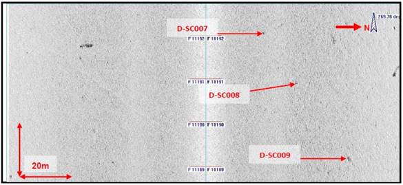
Figure 8.3 SSS Mosiac Showing the Overview of the Seabed of Po Toi (Southeast) FCZ
|
|

Figure 8.4 SSS Rectified Image Showing Seabed Sediments, Seabed Features and Shadows from Objects in Water Column
|
|

Figure 8.5 SSS Rectified Image Showing Seabed Sediments, Seabed Features and Shadows from Objects in Water Column
|
|

Figure 8.6 SSS Rectified Image Showing Sonar Contacts D-SC005 and D-SC006
|
|

Figure 8.7 SSS Rectified Image Showing Sonar Contacts D-SC007, D-SC008 and D-SC009
|
|
Figure 8.8 SSS Rectified Image Showing Sonar Contacts D-SC013
|
|

Figure 8.9 SSS Rectified Image Showing Sonar Contact D-SC053, D-SC054 and D-SC055
|
|

8.4.3 Establishment
of Marine Archaeological Potential
There are 85 sonar contacts (D-SC001 to D-SC085) identified in the Assessment Area, most of the sonar contacts are interpreted as debris, seventeen of sonar contacts are possibly gravel patches (D-SC002, D-SC003, D-SC012, D-SC014, D-SC015, D-SC026, D-SC029, D-SC031, D-SC033, D-SC046, D-SC049, D-SC053, D-SC059, D-SC061, D-SC064, D-SC071 and D-SC074), and four of the sonar contacts are linear debris (D-SC010, D-SC017, D-SC018 and D-SC082). Due to their random placement, the diminished intensity of the sonar contact, small in size, irregular shape, and lack of a shadow to indicate they have some elevation, they have been interpreted as natural material and of no archaeological potential. Sonar Contacts, D-SC005, D-SC009, D-SC013 & D-SC055 have comparatively strong signal strength and are of regular shape, and possibly of marine archaeology potential. Nevertheless, because of the muddy/silty seabed, objects such as cannon would sink into the seabed, these sonar contacts are most likely to be modern, recently deposited debris that would not be of high archaeological potential. There are no wrecks / obstructions found in the UKHO Wrecks database for the MAI Assessment Area. No other features of archaeological interest were observed in the area.
No sub-bottom anomalies of marine archaeology potential were observed.
8.5
Potential Sources of Impact
The
construction works of the proposed Po Toi (Southeast) FCZ, would mainly be
on-site assembly and anchorage of fish rafts/cages within the Project Area, and
will be carried out by the fish farmers who obtain marine fish culture licences
in this new FCZ. Maintenance dredging or removal of sediments is not
anticipated during FCZ operation under the Project.
Potential impacts arising from these activities include:
§ Direct loss of potential marine archaeological deposits due to seabed disturbance works during anchorage of the fish rafts/cages;
§ Indirect impact on access for future archaeological surveys; and
§ Permanent access disturbance to marine archaeological deposits if they are found to be within the Project Area.
8.6 Impact
Assessment
The desktop review found no sites of archaeological interest, declared monuments, proposed monuments, graded historic sites/buildings/structures and Government historic sites identified by the AMO fall within the Assessment Area. No construction phase and operation phase impact to these cultural heritage resources is anticipated. However, sonar contacts are identified from marine geophysical survey. Their impact assessment is discussed below.
8.6.1 Construction
Phase
The construction of fish rafts / cages will simply involve the use of tug boats to tow the main part of the fish rafts / cages to within the Project site, and to be assembled and anchored therein. No major marine construction works, such as dredging or works with significant seabed disturbance is expected. The fish rafts / cages will generally be gravity cages and the four corners of each cage will be anchored using weights and ropes and it is expected that the seabed to be disturbed by anchoring will be confined to a thin vertical surface layer (<0.5 m), and < 2m horizontally. Although potential impact on 81 sonar contacts (D-SC001 to D-SC085 except D-SC005, D-SC009, D-SC013 and D-SC055) located in Assessment Area as in Figure 8.1 is possible, the majority of them are interpreted as debris and gravel patches, and five of them are possibly tires. They are of no marine archaeological potential.
Potential direct impact on four sonar contacts (D-SC005, D-SC009, D-SC013, and D-SC055) that may be of marine archaeological potential due to construction work of fish rafts / cages is possible. Nevertheless, because of the muddy / silty seabed, objects such as cannon would sink into the seabed, the sonar contacts are most likely to be modern, recently deposited debris that would not be of high archaeological potential.
8.6.2 Operation
Phase
Potential direct impact on four sonar contacts (D-SC005, D-SC009, D-SC013, and D-SC055) that may be of marine archaeological potential during operation phase of the Project is possible.
Although potential impact on 81 sonar contacts (D-SC001 to D-SC085 except D-SC005, D-SC009, D-SC013 and D-SC055) located in Assessment Area as in Figure 8.1 is possible, the majority of them are interpreted as debris and gravel patches, and five of them are possibly tires. They are of no marine archaeological potential.
8.7 Mitigation
Measures
As no impacts to sites of archaeological interest, declared monuments, proposed monuments, graded historic sites/buildings/structures and Government historic sites identified by AMO are expected, no construction phase and operation phase mitigation measure for terrestrial cultural heritage is required. However, mitigation measures for the identified sonar contacts are recommended below.
8.7.1 Construction
Phase
Sonar contacts (D-SC001 to D-SC004, D-SC006 to D-SC008, D-SC010 to D-SC012, D-SC014 to D-SC054, and D-SC056 to D-SC085) are identified as debris or gravel patches, five of them are possibly tires, and they are regarded as of no marine archaeological potential. No mitigation measure is required.
According to Annex 10 of EIAO-TM, the general presumption is in favour of the protection and conservation of all sites of cultural heritage, the potential direct impact on four sonar contacts (D-SC005, D-SC009, D-SC013, and D-SC055) that may have marine archaeological potential will be avoided by isolating them with a 20 m radius buffer zone from any tug boat anchoring and anchoring of the fish rafts/cages as shown in Figure 8.1. The locations and relocations of fish rafts/cages are regulated by the Marine Fish Culture Ordinance (Cap. 353), and AFCD will ensure the locations of anchoring of vessels and fish rafts/cages will not be located within the buffer areas. Site inspections on a regular basis by the Environmental Team are recommended to check if any seabed disturbance work is conducted in the buffer areas.
8.7.2 Operation
Phase
The buffer area as shown in Figure 8.1 with 20 m radius from the four sonar contacts (D-SC005, D-SC009, D-SC013, and D-SC055) should be implemented during operation phase of the Project. AFCD will maintain the record of the buffer area and the locations of the fish rafts / cages. The locations and relocations of fish rafts/cages are regulated by the Marine Fish Culture Ordinance (Cap. 353), and AFCD will ensure the locations of anchoring of vessels and fish rafts/cages will not be located within the buffer area. AFCD will conduct regular inspections to check if any seabed disturbance work is conducted in the buffer areas.
Although potential impact on 81 sonar contacts (D-SC001 to D-SC085 except D-SC005, D-SC009, D-SC013 and D-SC055) is possible, they are of no marine archaeological potential, no mitigation measure is required.
8.8 Cumulative
Impacts
At present, there are no planned projects within the Assessment Area that could have cumulative cultural heritage impacts with the proposed Project. No cumulative impact or adverse residual impacts on marine archaeological resources are expected.
8.9 Conclusion
The desktop review supplemented with the results of the marine geophysical survey conducted for the Project identified 4 sonar contacts (D-SC005, D-SC009, D-SC013, and D-SC055) within the Project Area, which may be of marine archaeological potential. Nevertheless, because of the muddy / silty seabed, objects such as cannon would sink into the seabed, the sonar contacts are most likely to be modern, recently deposited debris that would not be of high archaeological potential. A buffer area with 20 m radius from each of the 4 sonar contacts (D-SC005, D-SC009, D-SC013, and D-SC055) is recommended to avoid any tug boat anchoring and anchoring of the fish rafts/cages in the areas so as to avoid any impact to these sonar contacts during both the construction and operation phases of the Project. The locations and relocations of fish rafts/cages are regulated by the Marine Fish Culture Ordinance (Cap. 353), and AFCD will ensure the locations of anchoring of vessels and fish rafts/cages will not be located within the buffer area. Site inspections on a regular basis by the Environmental Team are recommended to check if any seabed disturbance work is conducted in the buffer areas during construction phase of the Project. AFCD will conduct regular inspections to check if any seabed disturbance work is conducted in the buffer areas during operation phase of the Project.
8.10 Bibliography
8.10.1
English
AMO, 2012a, Declared Monuments in Hong Kong, Rock Carvings on Po Toi. From AMO web site.
AMO, 2012b, List of Sites of Archaeological Interest in Hong Kong (as at Nov 2012). From AMO web site.
Davis, S.G.; Edelstein, Shirlee; Madeleine H., Tang (26 September 1973). "Rock Carvings in Hong Kong and the New Territories". Asian Perspectives
EGS, 2021, Marine Geophysical Survey for Fish Culture Zone EIA Study: Site D – Po Toi - Preliminary Report. April 2021.
Morton B (1996) The Marine Biology of the South China Sea III. Proceedings of the Third International Conference on the Marine Biology of the South China Sea. Hong Kong University Press.
Peacock, B.A.V. 1985. Report of the Hong Kong Archaeological Survey. (Unpublished)
Rogers, Van Den Bergh et al 1997. Second Territory-wide Survey: Hong Kong and Po Toi Islands.
Antiquities and Monuments Office, Culture and Sports Department, Government of the Hong Kong SAR (Unpublished).
8.10.2
Chinese
東網2015年4月9日網上新聞報導: “潛水意外收獲
蒲台島海域現二戰古炮船錨”
8.10.3
Chart
1845-1849 China Sheet II Eastern Coast from Hong Kong to Chelang Point
1906 Chart No 2593:Hong Kong to Mirs Bay