Livestock Waste Information System
|
|
| |
|
| |
|
 |
 |
Yuen
Long East District
San
Tin
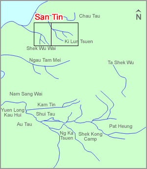
San Tin is a broad area in the Northwest New Territories, which is bonded by the Shenzhen River to the north, Lok Ma Chau to the east, Ki Lun Shan to the southeast and Mai Po the west. There are many unsewered villages scattered at San Tin and the livestock farms are more concentrated at its southern region, such as the Shek Wu Wai and Ki Lun Tsuen areas. San Tin has no large stream course while there are a few small ones flowing across its Shek Wu Wai and Ki Lun Tsuen areas. Livestock waste is the most significant pollution source.
The urbanization of San Tin is significant in recent years, which is indicated by the implementation of some large infrastructure projects, such as the Expansion of Kiosks at Lok Ma Chau Boundary Crossing, the KCRC Sheung Shui to Lok Ma Chau Spur Line and the New Boundary Bridge between Lok Ma Chau and Huanggang.
|
| |
|
|
|
|
| |
 |
|
|
|