DP 1, 2 and
3 Part I, A.1 – Construction of trunk roads, primary distributor roads and
district distributor roads
1.5.1.2
The major
objective of the proposed road network is to improve connectivity with Yuen
Long New Town, the proposed HSK NDA, and provides a direct access and egress to
YLH. Long Hon Road is proposed to be upgraded and extended to Kung Um Road to
form a key corridor of the PDA.
1.5.1.3
The road
system will provide direct and convenient access of freight traffic between the
Employment Belt in Area 1 and YLH without travelling through the residential
neighbourhood. The TSWW Interchange (trunk roads) is improved to increase
traffic movements and cater for direct access between the Employment Belt and
YLH through the westbound carriageway.
1.5.1.4
The improved
TYST Interchange (primary distributor roads) will be modified to cater for all
traffic movements to and from YLH, Long Tin Road and Long Hon Road.
1.5.1.5
In addition,
district distributor Road D1 will connect through TYST Interchange and Area 1
to Area 2 and 3 of the PDA, and district distributor Road D2 will connect Kung
Um Road, Lam Tai West/East Road to Road D1.
1.5.1.6
In addition, a pair of slip roads (local distributor roads)
running on both sides and parallel with YLH from Kung Um Road eastward are proposed to provide
connectivity to YLH via Shap Pat Heung Interchange. These roads
are local distributor roads which are not DPs.
1.5.1.7
For the
northern section of Kung Um Road and Kiu Hing Road (local distributor roads)
along Yuen Long Nullah, road widening will be undertaken through partial
decking of Yuen Long Nullah. For Kung Um Road, the existing two lanes will be
kept and changed to one-way direction, with minor road improvement works
including road widening and footpath provision. For Kiu Hing Road, the existing
one lane road will be upgraded as standard one-way 2-lane single carriageway.
This proposal allows provision of adequate road space for vehicles and
pedestrians. These roads are local distributor roads which are not DPs.
1.5.1.8
Since the
proposed works involve construction and major improvements of trunk roads,
primary distributor roads and district distributor roads, they will be DPs
under Item A.1 of Schedule 2, Part I of EIA Ordinance.
DP 4 - Part
I, A.3 - Construction of Environmentally Friendly Transport Services (EFTS) –
subject to further review
1.5.1.9
The RODP has
reserved a corridor for the extension of the EFTS proposed under the HSK NDA
project with possible connection to West Rail Tin Shui Wai Station. The reserve
navigates through the storage/workshops, residential, commercial and other land
reserves within the PDA. As mentioned in the approved HSK EIA report, a railway
transport system has been assumed for the purpose of the EIA. However, the EFTS
system is a separate DP to be constructed and operated by the future operator
who would need to prepare and submit a separate EIA Study for approval under
the EIA Ordinance.
DP 5 - Part
I, A.8 – Construction of a road bridge more than 100m in length between
abutments
1.5.1.10
As part of the
road improvement works, an elevated viaduct section of more than 100m in length
are proposed at TYST Interchange in the RODP.
1.5.1.11
Since the proposed works
involve construction of a road bridge more than
100m in length between abutments in the RODP, it will be a DP under Item A.8 of
Schedule 2, Part I of EIA Ordinance.
DP 6 - Part
I, A.9 – Construction of a road fully enclosed by decking above and by
structure on the sides for more than 100m in length
1.5.1.12
As part of the
TSWW Interchange improvement works, a depressed road/ underpass of more than
100m in length beneath the at-grade roundabout at the TSWW Interchange is
proposed in the RODP. In addition, full enclosures at TYST Interchange are also
required in order to comply the noise criteria.
1.5.1.13
Since the proposed works
involve construction of a fully enclosed road of
more than 100m in length in the RODP, it will be a DP under Item A.9 of
Schedule 2, Part I of EIA Ordinance.
DP 7 - Part
I, F.2 – Construction of a Sewage Treatment Works – subject to further review
1.5.1.14
With other
major developments including HSK NDA, Kam Tin South and housing sites at Wang
Chau, there is neither spare sewage treatment capacity at the nearby San Wai
Sewage Treatment Work (SWSTW) nor Yuen Long Sewage Treatment Works (YLSTW) for
the YLS development, despite planned upgrading of these sewage treatment works
(STWs). There is also little scope to further expand these two STWs after
discussions with the relevant authorities.
1.5.1.15
An “OU(STW)”
zone at the southern end of Kung Um Road is reserved for the construction of an
aboveground STW (YLS STW) for treatment and disposal of sewage arising from the
PDA. Based on the sewage estimation according to the RODP, the treatment
capacity of YLS STW would have an Average Dry Weather Flow (ADWF) of 24,000m3/day.
1.5.1.16
Since the proposed works
involve construction of sewage treatment works with
installed capacity more than 5,000m3 per day, and they are located
close to the planned receivers in the RODP, it will be a DP under Item F.3(b)
of Schedule 2, Part I of EIA Ordinance. However, the STW is a separate DP to be
constructed and operated by the future operator who would need to prepare and
submit a separate EIA for approval under the EIA Ordinance.
DP 8 - Part
I, F.3(b) – Construction of two sewage pumping stations
1.5.1.17
Two
“OU(RCP&SPS)” zones are intended for the sewage pumping stations (SPSs) and
refuse collection points (RCPs).
1.5.1.18
The SPS site located
to the east of TYST Interchange in Area 1 is reserved for an intermediate SPS
to pump the sewage collected from the Area 1 for further discharge by gravity
sewerage to the YLS STW for treatment, as well as an RCP. The ADWF of the SPS
would be approximately 4,700m3/day.
1.5.1.19
The other SPSs
site located to the west of the northern end of Kung Um Road in Area 2 is reserved to
retain the existing Lung Tin SPS, construct a SPS to pump the sewage collected
from the Areas 2 and 3 by
underground gravity sewers to the YLS STW for treatment, as well as an RCP.
The ADWF of the SPS would be approximately 23,280m3/day
at the northern end of Kung Um Road.
1.5.1.20
Since the proposed works
involve construction of SPS with installed capacity
more than 2,000m3 per day, and
they are located close to the planned receivers in the RODP, it will be a DP
under Item F.3(b) of Schedule 2, Part I of EIA Ordinance.
DP 9 - Part
I, F.4 - An activity for the reuse of reclaimed water from a treatment plant –
subject to further review
1.5.1.22
Since the proposed works involve reuse of reclaimed water from a treatment
plant, it will be a DP under Item F.4 of Schedule 2, Part I of EIA Ordinance. However,
the reuse activity is a separate DP to be constructed and operated by the
future operator who would need to prepare and submit a separate EIA for
approval under the EIA Ordinance.
DP 10 - Part I, I.1(b)(vii) - Yuen Long
Nullah Revitalisation
1.5.1.23
Yuen Long Nullah will be partially decked to
provide space for road widening and provision of landscaped footpaths at Kung
Um Road and Kiu Hing Road. The nullah will also be reviatlised and integrated
in the urban design and landscape framework.
1.5.1.24
Since the proposed works involve a drainage
channel or river training less than 300m from the nearest boundary of an existing
Conservation Area under TYST OZP Plan No. S/YL-TYST/10, it will be a DP under
Item I.1(b)(vii) of Schedule 2,
Part I of EIA Ordinance.
1.5.1.25
This EIA study will therefore cover all the
Schedule 2 DPs mentioned except DP4, DP7 and DP9 in Table 1.1.
1.6.1.1
Apart from the Schedule 2 DPs as listed in Table 1.1, there are also a number of
non-DP elements in the RODP including but not limited to the following
sub-elements summarised in Table 1.2.
Details of these non DP elements are presented in Chapter 3 and their locations and lot reference are shown in Figure 3.1.
Table
1.2 Summary of
non-DPs
|
Non DPs |
Sub-elements |
|
Residential Uses |
·
Special Residential – Public Rental Housing (with commercial)
(“RSc”) ·
Residential - Zone 1 (Subsidised Sale Flats) (with commercial)
(“R1(SSF)c”); ·
Residential - Zone 2 (Subsidised Sale Flats) (with commercial)
(“R2(SSF)c”) ·
Residential - Zone 1 (with commercial) (“R1c”) ·
Residential - Zone 2 (with commercial) (“R2c”) ·
Residential - Zone 2 (“R2”) ·
Residential - Zone 3 (“R3”) ·
Residential - Zone 4 (“R4”) ·
Residential - Zone 5 (“R5”) ·
Residential - Zone 5 (Existing Development Area (“R5(EDA)”) ·
Residential - Zone 6 (“R6”) ·
Other Specified Uses (Mixed Use) (“OU(MU)”) |
|
Storage and
Workshop Uses |
·
Other Specified Uses (Open Storage) (“OU(OS)”) ·
Other Specified Uses (Storage Use) (“OU(SU)”) ·
Other Specified Uses (Storage + Workshop) (“OU(S+W)”) |
|
Government,
Institution or Community |
·
Government (“G”) ·
Institution or Community (“IC”) |
|
Education |
·
Education (“E”) |
|
Public Utilities
(“OU”) |
·
Other Specified Uses (Sewage Treatment Works) (“OU(STW)”) ·
Other Specified Uses (Refuse Collection Point and Sewage Pumping
Station) (“OU(RCP&SPS)”) ·
Other Specified Uses (Electricity Substation) (“OU(ESS)”) ·
Other Specified Uses (Service Reservoir) (“OU(Service Reservoir)”) ·
Other Specified Uses (Hillside River Corridor with Scenic Cycle
Track) (“OU(Hillside River Corridor with Scenic Cycle Track)”) (1) |
|
Road and River
Channels |
·
Local Roads (L1 – L27) ·
Lam Tai East Road ·
Lam Tai West Road ·
Kung Um Road ·
Kiu Hing Road ·
Tam Kwai Tsuen Road ·
Lam Yu Road ·
Tai Kei Leng Road ·
Long Ho Road ·
Yuen Long West Nullah Revitalisation ·
Tin Tsuen Channel Revitalisation |
|
Amenity |
·
Amenity (“A”) |
|
Open Space |
·
District Open Space (“DO”) ·
District Open Space (1) (“DO (1)”) ·
Local Open Space (“LO”) ·
Local Open Space (1) (“LO (1)”) |
|
Agriculture |
·
Agriculture (“AGR”) |
|
Green Belt |
·
Green Belt (“GB”) ·
Green Belt (1) (“GB(1)”) |
|
Village Type
Development |
·
Village Type Development (“V”) |
Note:
(1) “OU (Hillside River Corridor) with Scenic
Cycle Track” also includes reedbed/retention pond.
7.
Green
Initiatives, Project Benefits and Environmental Initiatives
Green Initiatives
1.7.1.1
The vision of
the Project is to create a sustainable, green and liveable community provided with
supporting infrastructure to cater for future development needs.
1.7.1.2
With the
increasing awareness on sustainable development, green building design,
energy-efficient features and renewable energy technologies within the PDA have
also been duly considered. The Project has adopted a sustainable strategy in
the guiding principles, in respect of town planning, urban design,
transportation and blue-green infrastructure for a creation of a sustainable
local community. Within the PDA, green mobility is promoted through the
reservation of space for EFTS, and comprehensive pedestrian walkways and cycle
track networks.
1.7.1.3
In addition to
green transport management, a comprehensive water management system including
sewerage, drainage and water resources infrastructure has been recommended. To
promote sustainable use of water, opportunities for reuse of TSE as reclaimed
water for non-potable uses such as toilet flushing within the PDA and adjacent
developments have been considered. Blue-green infrastructure, such as the retention
tank, reedbed/ retention pond, retention lake and Hillside River Corridor to
collect runoffs from terrains, will be used for temporary storage of
stormwater.
1.7.1.4
As part of the
urban design initiative, sections of the existing Yuen Long (West) Nullah, Tin
Tsuen Channel, and Yuen Long Nullah are proposed to be revitalised. After the
revitalisation, these nullahs would provide an aesthetic environment for the local community. The
nullahs will provide a rural, natural sensation in the urban community and act
as key north-to-south connectivity corridors together with provisions of
pedestrian walkway and cycle track networks.
1.7.1.5
Subject to
further review, the above green initiatives will be implemented for future
developments.
1.7.1.6
The proposed
green initiatives are summarised in Table
1.3 under the following themes: Green Mobility, Comprehensive Water
Management, Solid Waste Management, Sustainable Drainage System, and Green
Energy Saving.
Table 1.3 Proposed Green Initiatives
|
Themes |
Green Initiatives |
|
Green Mobility |
Create a compact and walkable urban development by
concentrating population, key economic activities and major community
facilities within walking distance of public transport nodes. |
|
Create local communities with easily accessible
daily necessities to promote walking. |
|
|
Provide comprehensive, convenient and attractive
cycle track and pedestrian walkway networks with supporting facilities such
as bicycle parking areas and footbridges, crossing facilities and rest areas,
etc. to promote walkability and cycle friendliness. The total length of new
cycle tracks within the PDA is approximately 11 km. |
|
|
Provide Employment Belt to increase the local
employment opportunities and hence reduce the need for commuting traffic and
subsequently the generation of vehicular noise and air pollutant emissions. |
|
|
Comprehensive Water Management |
Incorporate dual process of tertiary and secondary
plus treatment at the proposed YLS STW allowing treated sewage effluent (TSE) to be reused as reclaimed water as much as
practicable. |
|
Reuse of TSE as reclaimed water for non-potable uses
such as toilet flushing. |
|
|
Solid Waste Management |
Reductions in the amount of municipal solid waste
generated and disposed of through an onsite waste management plan including
local recycling of organic waste, local recycling of glass for building
blocks production and source separation of recyclables. |
|
Explore the feasibility to adopt automatic refuse collection system to
reduce fuel use, odour and noise of waste transport. |
|
|
Sustainable Drainage System |
Provide flood retention facilities as a regulating
measure to overall drainage system and as a microclimate cooling mechanism
through integrated design with the open space system for public enjoyment. |
|
Combine flood retention facility with Hillside River
Corridor with Scenic Cycle Track, which formed part of the blue-green
infrastructure of the area. The Scenic Cycle Track would complement the
blue-green network to maximize opportunity for public enjoyment of the
natural landscape scenery and for recreation activities. |
|
|
Collect rainwater for non-potable purposes for
buildings. |
|
|
Revitalise northern section of Yuen Long Nullah
within the PDA by partial decking and adopt comprehensive regeneration design
along the whole drainage system. The ecological system and aesthetic value
along southern section of Yuen Long Nullah, Yuen Long (West) Nullah and Tin
Tsuen Channel will be enhanced with pedestrian walkways introduced. The total
length of nullahs revitalised is approximately 4.5 km. |
|
|
Regenerate sections of nullahs as the major green
spines, breezeways and view corridors and enable better integration between
different neighbourhoods. |
|
|
Green Energy Saving |
Encourage environmentally friendly building design
and materials, and energy-saving installations such as solar hot water
systems. |
|
Appropriate active and passive measure for energy efficient building
design during construction and operation phases. |
|
|
Promote certification under BEAM Plus or other
equivalent accreditations for all new buildings. |
|
|
Explore development of community gardens in open
space and amenity areas to promote green living. |
Benefits of the Project
1.7.1.7
The PDA
contains many brownfield sites (including open storage yards, warehouses,
industrial workshops, etc.) as well as villages, residential settlements,
agricultural land and vacant land. These brownfield sites have created
considerable environmental, traffic, visual, and other nuisance to the
neighbouring communities. One of the overarching objectives of the Project is
to transform these brownfield sites to more optimal uses and better land
utilisation for development and promote urban-rural symbiosis. The development
of the Project could result in the following direct benefits:
·
Alleviate scarcity of housing supply – The Project will provide about 28,500 new flats,
with a ratio of almost 6:4 between public housing (including public rental
housing and subsidised sale flat) and private housing. This will provide a
variety of housing types, responding to the needs of the community and
improving the quality of life.
·
Create local job opportunities – Approximately 10,500 new job places would be
generated upon full development of the Project, through a mix of proposed
industrial workshop and storage, commercial, community, and government land
uses. To take advantage of the close connection with highway network and reduce
environmental impacts on the residential neighbourhood, an Employment Belt is
designated along YLH for storage and workshop uses. These planned uses will
provide local employment opportunities as well as ease congestion at the
commuting corridors between the NWNT and the urban areas. Both the existing and
planned population will be benefited from these new job opportunities.
·
Commercial Provision to Meet Local Needs – Commercial
uses would be allowed on the lower floors within the residential zones, and in
mixed commercial and residential developments. The mixed-use developments incorporated with PTI are planned at three locations to serve
different parts of the PDA, i.e. one in each of the three Areas. These PTIs are all located near the existing villages. The commercial area would provide space for shops
including street-front shops and restaurants. The commercial facilities in YLS
could add vibrancy to the area and alleviate the commuting needs of YLS
residents and the existing residents and villagers in the vicinity of YLS.
·
Provide spaces for Storage and Workshop – The
Employment Belt in Area 1 provides a major local employment cluster. About
11 ha of land are reserved for storage, workshop and open storage uses. This
provides a designated area for the consolidation of brownfield activities
within the PDA.
·
Provide G/IC facilities – The Project has proposed various G/IC facilities
including clinic, community hall, police station, divisional fire station and
ambulance depot, post office, sports centre and market, educational facilities,
social welfare facilities, recreation facilities, etc. All these facilities
will serve both existing rural communities and the planned population.
Environmental Initiatives
1.7.1.8
Environmental
considerations have been the key factors in the planning of the YLS PDA.
Throughout the whole formulation process of the RODP, environmental impacts as
well as benefits are both identified and critically considered. Through
appropriate integration of proposed land uses into the plan, the Project offers
potential environmental initiatives both to conserve existing environmental
resources and, where opportunities exist, to enhance and upgrade the
environment on various fronts. The environmental initiatives that the Project
offers are summarised below:
·
Minimize
industrial / residential interface;
·
Conservation
of egretry and other ecological resources;
·
Reducing
commuting traffic by providing local employment opportunities;
·
Revitalisation
of nullahs;
·
Rezoning of
degraded brownfield sites for development;
·
Providing
sewerage system within the PDA and STW;
·
Reuse of
reclaimed water;
·
Providing sustainable drainage system within the
PDA;
·
Protection of
watercourses of higher ecological value;
·
Providing greening for the PDA;
·
Preservation
of agricultural land, secondary woodland and integration with natural greenery;
·
Encouraging
green commuting within and beyond the PDA;
·
Clearance of
existing odour sources; and
·
Catering for
the future e-buses and electric vehicles.
1.7.2
Minimize
Industrial / Residential Interface
1.7.2.1
One of the objectives of developing the Project is to convert those
brownfield sites within the PDA to more optimal uses and improve the overall
environment of the area. The proposed multi-storey buildings in the Employment
Belt near YLH would accommodate the brownfield operations. The Employment Belt
next to the YLH will provide convenient access to the strategic highway
network. Through consolidation of the brownfield operations in the Employment
Belt, this will help to alleviate existing industrial/residential interface
issues resulting from existing brownfield operations. Also, the freight traffic
would not need to travel through the residential neighbourhood in the PDA.
Also, these multi-storey buildings would
serve as a physical barrier to reduce industrial noise from the existing
industrial zone outside the PDA near Fui Sha Wai and the road traffic noise
from YLH.
1.7.3
Conservation
of Egretry and other Ecological Resources
1.7.3.1 An active egretry near Pak Sha Tsuen, woodland patches and a large piece of agricultural land near TYST, and few sections of watercourses of higher ecological value were found within and near the PDA, and the RODP has proposed to conserve them.
1.7.4
Reducing
Commuting Traffic by Providing Local Employment Opportunities
1.7.4.1
Currently, a large area of YLS PDA of
approximately 100 ha is occupied by brownfield operations such as warehouses,
open storage yards, vehicle repairs, waste recycling yards and other rural
industrial workshops. While it is
recognised that the industrial uses provide backup services to the logistics
industry and employment opportunities for locals, the intermingled land uses
have been exerting various issues and nuisance on the environment, such as the
noise nuisances from truck movements, odour and visual nuisance from
operational activities, etc.
1.7.4.2
Taking
advantage of the close connection with the highway network, the Employment Belt
has been proactively proposed along YLH where the area is easily accessible to
the highway and freight traffic would not need to travel through the
residential neighbourhood in the PDA. The RODP has proposed zonings for the
northern part of Area 1 as “Storage Use”, “Storage and Workshop”, “Open
Storage” and “Mixed Use”. Approximately 1.4 ha of land for open storage use and
approximately 10 ha of land for storage and workshop uses are proposed, which
are intended to support industrial and logistic operations.
1.7.4.3
Multi-storey
building sites are planned at the “Storage Use” and “Storage and Workshops”
zones to consolidate the existing operations on brownfield. To further
segregate industrial land uses and residential areas, a network of open spaces
has also been planned while the setback distance has been allowed to address
road traffic noise issues, the multi-storey buildings could also serve as a
screen to further reduce the impacts of road traffic noise from YLH on the
residential areas in the southern part of Area 1.
1.7.4.4
It is
anticipated that about 10,500 jobs will be created and these local job
opportunities can help reducing need for community traffic traffic
from both existing and planned population and hence the associate air emissions and traffic noise nuisance for
the existing sensitive receivers along the commuting routes would be reduced.
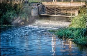
Conceptual diagram of revitalised river channel (Overview)
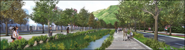
Conceptual diagram of revitalised river channel
1.7.6
Rezoning of
Degraded Brownfield Sites for Development
1.7.6.1
Currently, approximately 100 ha of land within
the PDA is degraded brownfield sites used for industrial purpose and the
original agricultural lands have already been disturbed by brownfield operations.
The brownfield area is mainly zoned as “Undetermined” and the remaining ones
are zoned as “I(D)”, R(D) etc. on the approved Outline Zoning Plan TYST OZP No.
S/YL-TYST/10 and these areas will be zoned for other uses including open space,
residential, G/IC, etc.
1.7.6.2
However, the original agricultural lands have
already been disturbed by brownfield operations. Various ecological habitats
have been identified within the PDA and its vicinity (see Chapter 8 for details). They include an active egretry in Pak Sha
Tsuen, woodland patches and a large piece of agricultural land near TYST, and
few sections of streams within the PDA. The RODP has considered the value of
these important environment receivers and has proposed to conserve them.
1.7.6.3
During the earlier planning stage, the
boundaries of the PDA are designed to avoid encroachment onto these
ecologically important resources as far as practicable, such as the
Ecologically Important Stream (EIS) near Yeung Ka Tsuen, which is now located
outside the PDA boundary. Moreover, the planned roads and road junctions have
avoided the woodlands and the agricultural land as far as practicable, to avoid
and minimize disturbance and fragmentation of those habitats.
1.7.6.4
Therefore, the Study has proposed rezoning of
these areas, so that the ecologically important resources within these
“Undetermined” land uses can be conserved. Nevertheless, there would still be
approximately 5.5ha of woodland of various ecological quality that would be
inevitably affected, and hence would require compensation (see Section 8 for more details).
1.7.6.5
On this basis,
landuse of the areas within the PDA near these ecologically important resources
have been proactively designed to
minimize human disturbance and provide additional setback where practicable.
For instance, zonings of “District Open Space” (“DO”), “Local Open Space”
(“LO”) and “Amenity Areas” (“A”) are proposed at the southern tip of Area 3
which is near Tai Lam Country Park and Yeung Ka Tsuen EIS, while “District Open
Space” (“DO”) and “Local Open Space” (“LO”) are proposed in Area 2 near the
egretry at Pak Sha Tsuen. These land uses are characterized by less
human disturbance, and offer additional setback to the ecological habitats.
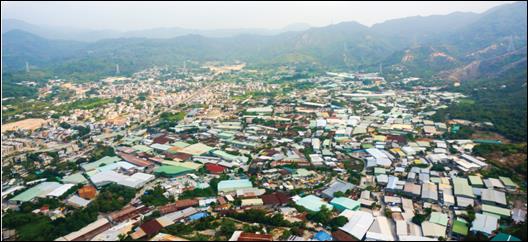
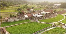
Aerial photo of existing brownfield sites
1.7.7
Providing
Sewer System within the PDA and STW
1.7.7.1 There has been long-term improvement in Water Quality Objectives (WQO) compliance rate and Water Quality Index (WQI) grades of Hong Kong’s inland water courses (see Section 6 for water quality baseline conditions). Despite the trend of general improvement, according to the EPD River Water Quality in Hong Kong 2014, the water quality of the water courses including those in YLS forming Yuen Long Creek have a range of Water Quality Index grading from “Bad” to “Fair”.
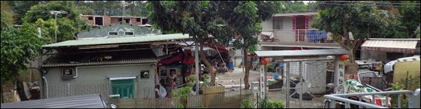
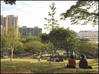
Existing villages
1.7.7.2
Majority part of the PDA is currently without
any centralised sewage treatment facilities, and some of the watercourses may
be subject to discharges from various sources such as livestock farms,
unsewered village houses and industrial establishments. The estimated existing unsewered population within the scattered
villages and brownfield sites within the PDA is approximately 280 persons
(about 100 households), and the estimated employment is about 4,500 persons
within the existing brownfield sites within the PDA. With the proposed
YLS STW implemented under the Project, all the areas within the PDA boundary
will be provided with sewers that convey the sewage to the new STW. Hence, all
existing unsewered population within the PDA will be sewered and the
watercourses in the vicinity are anticipated to have potential benefits from
the improvement in water quality for the benefit of the wider community.
1.7.8
Reuse of
Reclaimed Water
1.7.8.1
Due to the scarce pollution credit in the Deep
Bay Water Control Zone (WCZ), reuse of TSE as reclaimed water will be
implemented for the PDA and adjacent developments for non-potable uses such as
toilet flushing, while the surplus TSE will be discharged from YLS STW to the
existing inlet chamber of the NWNT effluent tunnel at San Wai for discharging
to the Urmston Road submarine outfall.
1.7.8.2
A small amount of TSE will be separately
discharged to the reedbed adjoining to the proposed YLS STW for further
polishing before entering the revitalised Yuen Long Nullah for creation of
water bodies. It has been proven that reedbed is capable to further polish the
reclaimed water by means of the biological breakdown process. According to the
Sewerage Impact Assessment, the reedbed removal efficiency are approximately
50% for Nitrogen, 90% for Suspended Solids (SS), 30% for 5-day Biological
Oxygen Demand (BOD5) while the remaining loading could be partly compensated by
the pollution credit gained from the replacement of existing livestock farms.
The tertiary TSE after treatment in STW would only pass through the reedbed but
not other receiving bodies such as the Hillside River Corridor, retention lake
etc., before entering the revitalised Yuen Long Nullah. Hence, the TSE to be
discharged to Yuen Long Nullah would not lead to a net increase in pollution loading
in the Deep Bay WCZ.
1.7.9
Providing
Sustainable Drainage System within the PDA
1.7.9.1
Flood retention facilities such as flood retention
tank/ lake/ pond are proposed to cater for the additional runoff caused by the
PDA. These storage devices retard residence time and alleviate peak flows.
Instead of expelling flood water, these measures hold up water and therefore
can maintain steady river flows during drier periods. These measures will also
serve for amenity purposes and enhance the landscape and visual environment.
Retention
tank
1.7.9.2
According to the Drainage Impact Assessment (DIA)
under the Study in order to mitigate the
increased flow from the development, a retention tank at Area 1 has been
proposed to attenuate the peak flow, such that the peak outflow to the existing
Yuen Long (West) Nullah would attain insignificant change in flow rate. The
area and storage volume of the retention tank in Area 1 are about 2,000 m2
and 10,500 m3 respectively.
Hillside
River Corridor and Retention Lake
1.7.9.3
A retention lake and Hillside River Corridor have
also been proposed at the upstream of Tin Tsuen channel (along Lam Tai
East/West Road) to temporarily store the 50 year peak runoff from the existing
hillside catchment and catchments from proposed development in Areas 2 and 3,
and hence to mitigate the increase in peak surface runoff from the PDA. The
retention lake and Hillside River Corridor will also serve for amenity purposes
and enhance the landscape and visual environment. According to the DIA under
the Study, the area and storage volume of the retention lake are approximately
0.6ha and 13,000 m3 respectively. The Hillside River Corridor runs
along the PDA boundary and is about 575m and 0.37ha, with a storage volume of
about 3,200m3. By intercepting several hillside streams, this new
watercourse will provide hydrological and ecological connectivity to downstream
sections. The new watercourse will be designed to maximize ecological
opportunities for aquatic flora and fauna and provide new linkages to several
fragmented/isolated watercourses.
Consideration should be given to the creation of an island within the
Retention Lake, planted with a mixture of native trees and bamboo suitable for
nesting ardeids. With appropriate
planting and careful design at the detailed design stage, the Retention Lake
can provide potential opportunities for waterbirds.
Reedbed/
Retention Pond
1.7.9.4
A reedbed/ retention pond of approximately 4 ha
has been proposed at the south of Area 3. The reedbed can act as a sponge that
traps and slowly releases surface water. Reeds can slow the speed of stormwater
and distribute slowly over the area. In addition to the benefits of flood
control, the permeability of reedbed allows infiltration of rain water that
replenishes groundwater. This reedbed also serves as a visual element for the
local community. The reedbed
can provide ecological enhancement to the area providing foraging opportunities
and shelter for a suite of aquatic fauna, and in particular, wetland dependent
birds.
Sustainable drainage
system
Photomontage of the Hillside
River Corridor and the Retention Lake
1.7.10
Protection of
Watercourses of Higher Ecological Value
1.7.10.1
Three
watercourses with endemic crab species (e.g. S. zanklon) have been identified within the PDA (see Chapter 8 for more details). However,
under the current statutory plans, these watercourses presently lack
appropriate protection.
1.7.10.2
A conservation
zoning of (“GB(1)”) covering 15m buffer on both sides of the streams is
proposed along the streams identified with endemic crab species. This would
cover two sections of watercourses with a total length of about 1.6km in
Area 1, and one section of about 310m in Area 3 of the PDA. Area zoned as Green Belt will be primarily
conserved for its existing natural environment to safeguard it from
encroachment by urban type developments. Any activities that are not favourable to the
environment would be prohibited in these “GB(1)” zones and would therefore
conserve the environmental conditions of these watercourses. In response to the comment received in CE3,
the channelised watercourses which are the extension of those
streams/watercourses with endemic crab species are also zoned “GB(1)” with an additional intention to revitalise these
channelised watercourse when opportunity arises in order to achieve habitat
protection. This zone protects the habitats for wildlife from unauthorized
encroachment and illegal dumping, while providing flexibility to the Town
Planning Board to scrutinise developments under the planning permission system.
1.7.11
Providing Greening for the PDA
1.7.11.1
Greening is also another key consideration in
formulating the RODP. According to the current proposal, a Green Zone of about
15 ha to preserve the existing agricultural land has been designated to enhance
the local character, green landscape and linkage between urban and rural areas. In addition
to the Green Zone, greening space/planting would be provided in the open space,
amenity areas, along the Hillside River Corridor and reedbed/ retention pond.
1.7.12
Preservation
of Agricultural Land, Secondary Woodland and Integration with Natural Greenery
Preservation of Green Belt and Agricultural
Land
1.7.12.1
YLS was
thrived with agricultural activities in the 1960’s, attributed to the open and
fertile plain with easily accessible water for irrigation. Despite most of the
agricultural land had been converted into other land uses or become abandoned
over the decades, a cluster of mixed dry and wet agricultural land (about 11 ha
in total) is being retained at the southeast portion of Area 1 (the Green
Zone). Besides, two patches of secondary woodland in Area 1 and the strips of
land along the southwestern boundary of Area 1 which are part of woodland of
the hillslope are preserved and zoned “Green Belt” (“GB”).
1.7.12.2
It is proposed
to preserve some of the agricultural lands with a designated zoning as
“Agriculture” (“AGR”) on the RODP. While there are currently small pockets of
inactive agricultural land scattered within the proposed AGR zone, it is
anticipated that the rezoning will facilitate agricultural rehabitilization.
Provide
Linkage between Agricultural land and Secondary Woodland
1.7.12.3
Preservation
of the agricultural land would improve visual links to natural terrain and
landscape features in the surround. The proposed “AGR” zone presently borders a
large piece of mature secondary woodland to the south (about 18 ha), and
adjoins continuous shrubland/grassland to the west which further extends to the
Tai Lam Country Park. Preservation of the agricultural land and secondary
woodland would improve visual links to natural terrain and landscape features
in the surrounding. One of the
watercourses of higher ecological value mentioned in Section 1.7.10 also runs into the clustered agricultural land.
1.7.12.4
Efforts were
made to conserve the active agricultural land and the adjacent mature secondary
woodland. The active agricultural land and secondary woodland in the southern
part of TYST has been identified and would be preserved by “AGR” and “GB”
zonings so as to avoid incompatible use and development. Besides, the proposed
road network between Areas 1 and 2 is aligned to the edge of the PDA as much as
possible to minimize habitat fragmentation (see Figure 3.1), while avoiding intrusion to the village environs on the other side.
The road alignment has been adjusted to pass though the eastern limit of the
agricultural land away from those areas with good ecological connectivity. On
the other hand, the footprint of the segment of Road D1, which encroached on
the agricultural land, has been reduced to minimize the disturbance to the
habitat (see Chapter 8 for more details).
Through proper designation of zoning
for agricultural use and conservation and due consideration to the road
alignment, it is anticipated the preserved open fields with extended natural
greenery would form a core Green Zone.
1.7.12.5
Existing
secondary woodland and plantation would be retained as much as possible by
rezoning to open space and amenity areas zonings (e.g. “A” and “DO” zones
proposed next to TSWW Interchange).
Preservation of
agricultural lands and provide open space and amenity areas
1.7.13
Encouraging
Green Commuting and Walking within and beyond the PDA
1.7.13.1
Comprehensive
networks of pedestrian walkways and cycle tracks are planned within the PDA to
promote green commuting. Key pedestrian corridors will be provided with amenity
planting to enhance the walking environment for pedestrians. Besides, cycle
tracks of about 11km will also be built across the PDA and be connected to
other districts such as Ping Shan, Tin Shui Wai New Town and Yuen Long New
Town. There are two connection points between the proposed cycling network of
the PDA and the external existing / planned cycle tracks. One of the connection
points is along Fui Sha Wai South Road near TSWW Interchange, and the other one
is along west of Long Tin Road near TYST Interchange. Cycling track and
pedestrian walkway networks are also proposed to connect the PDA with Tai Lam
Country Park. All these measures are proposed to facilitate walking and cycling
activities across the PDA and in the wider community.
1.7.13.2
During the formulation of the RODP, space
has been reserved for a possible introduction of an EFTS within the PDA. In the event that a possible EFTS being
considered for the HSK NDA is extended to YLS, the extension could run along
the reserved space to serve the YLS PDA.
If such a system is introduced, this would give the YLS community
another green transport option and more enhanced transport connection to the
HSK NDA.
1.7.13.3
Currently,
there is a lack of commercial and community facilities within the PDA and
residents have to travel to Yuen Long New Town for their daily necessities. The
RODP has planned commercial space for retail facilities and has planned G/IC
facilities such as educational uses, sports and recreational facilities,
elderly homes, clinic and community hall, etc. These facilities can reduce
travel distance/trips of both existing and future residents of the near
community to Yuen Long New Town. These provisions can also relieve the stress
on public transport systems and minimize the associated environmental issues.
All these facilities would be shared by both the existing rural communities and
the planned populations and hence promotes the urban-rural symbiosis which
could be further enhanced through improvement of village access to the PDA.

Environmentally-friendly
modes of transport
1.7.14
Clearance of
Existing Odour Sources
1.7.14.1
Currently, there
are six livestock farms in the YLS PDA, including three pig farms and three
chicken farms. For the sake of minimising the risk of avian influenza in Hong
Kong, the Government has since 2008 adopted a policy of containing the scale of
live poultry trade in Hong Kong, with the total rearing capacity of live
chickens capped at 1.3 million. Under the existing statutory provisions, there
are constraints in relocating the affected chicken farms due to government
policies.
1.7.14.2
Three livestock
farms (one pig farm and two chicken farms) that are located in the central
locations of the PDA have inevitably to be cleared. The chicken farms could not
be relocated due to statutory restriction. In order to strike a balance among
public opinions, to minimize anticipated interface issue with existing and
future residents and to minimize odour impact, only one chicken farm located at
the most southern fringe of the PDA is retained. Sufficient buffer area has
been reserved in the RODP to mitigate for odour impact due to the retained
chicken farm.
1.7.14.3
For the two pig
farms located at the southern end of Kung Um Road, taking into account the
adverse odour impact and the opinions of the public, the two pig farms at the
southern end of Kung Um Road could not be retained under the RODP. The areas
are rezoned as “G” for government depot and serve as part of the buffer between
the retained chicken farm and sensitive land uses.
1.7.15
Catering for
the Future E-buses and Electric Vehicles
1.7.15.1
The
technological advancement in the last decade has demonstrated the feasibility
of adopting more environmentally friendly buses in city environment. According
to “A Clean Air Plan for Hong Kong” published by the Environmental Bureau in
Year 2013 (http://www.enb.gov.hk/en/files/New_Air_Plan_en.pdf) which sets out in detail the various measures to
tackle air pollution from power plants, land and sea transport, and non-road
mobile machinery and to strengthen collaboration with Guangdong to deal with
regional pollution. One of the options is the implementation of electric buses
(e-buses), which could help to eliminate one of the major roadside sources of
particulates generated by conventional buses relying on diesel fuel.
1.7.15.2
Although the
feasibility and implementation issues of adopting e-buses in Hong Kong are yet
to be demonstrated, it would be important to have a space provision for
charging facilities within the new PTIs. According to the current landuse
planning, there will be a total of 4 PTIs – 3 within the PDA and 1 outside the
PDA near Yoho Midtown. These new PTIs will be designed with sufficient space to
allow for the installation of charging facilities by the bus operators in a
timely manner.
1.7.15.3
Furthermore,
the rapid technology development in this field has
encouraged the promotion of using electric vehicles (EVs) to combat roadside
air pollution problems. Apart from the assignation of charging facilities for
e-buses within the new PTIs, it is also suggested to include EV charging
facilities in car parks of the new private and public residential developments.
1.7.15.4
This provision
in the new developments will serve as an environmental benefit to help reduce
vehicular emission in the future.
1.8.1.1
In order to assess
the cumulative impacts, a review of best available information at the time of
preparing this EIA report to identify a number of other projects that are
undergoing planning, design, construction and/or operation within the
construction and/or operation period for the Study has been conducted and a
list of the tentative concurrent projects identified at this stage is
summarised below and Figure 1.3 shows the
locations of these concurrent projects. Various cumulative impacts for
different concurrent projects have been identified and detailed justifications
on consideration of various environmental cumulative impacts from individual
concurrent projects has been included in corresponding technical chapters. During the subsequent detailed design stage
of YLS development, it is proposed to conduct an environmental review to collate
any further available information at that time for updating the cumulative
impacts, including but not limited to the implementation programme of
concurrent projects such as HSK NDA.
HSK NDA Planning and Engineering Study
1.8.1.2
The development at HSK NDA will help to create new
development land for the provision of approximately 61,000 new flats thereby
contributing toward Hong Kong’s housing supply targets. The HSK NDA project
also aims to increase land supply for economic use by providing employment opportunity
of about 150,000, in order to achieve the vision of building a sustainable,
people-oriented and balanced living and working community for Hong Kong. This
would help to address the over concentration of commercial activities and
employment opportunities in the main urban areas, boost the vibrancy of local
communities, meet the short fall of jobs in Tin Shui Wai New Town, as well as
ease congestion at the commuting corridors between the New Territories and the
urban areas.
1.8.1.3
The study commenced in mid-2011 and the final EIA
Report was approved in December 2016. The project is targeted to commence the
construction in 2019 with the first population intake in 2024. As the
nearest works boundary of that study is located at about 450m away from the YLS
PDA, air quality, noise, sewerage and ecological impact during both
construction and operational phase are anticipated.
Engineering Works at Lin Cheung Road Site, Sham Shui
Po and Wang Chau, Yuen Long
1.8.1.4
To
support the proposed public housing development, CEDD commissioned the study
for the provision of essential infrastructure. The first phase of building
works of the housing flats at Wang Chau is targeted to commence in 2017/2018
and complete by 2024/2025. Another study by the Hong Kong Housing Authority (HA)
in 2012 studied the potential housing development at Wang Chau and the boundary
of the project is derived from the public housing site at Wang Chau as proposed
by HA.
1.8.1.5
As the
works boundary of the proposed Wang Chau site is located more than 1km
away from the YLS PDA, cumulative impact is not anticipated during construction
phase. However, impact from vehicular emission during both construction and
operational phase, and road traffic noise impact during operational phase are
anticipated from the induced traffic.
Site Formation and Infrastructural Works for the
Development at Long Bin, Yuen Long, Feasibility Study
1.8.1.6
The project is to conduct an engineering
feasibility study to examine the feasibility of developing public housing at
the potential site at Long Bin, Yuen Long; to determine the scope of site
formation and infrastructure works for supporting the development; and to
provide essential engineering information to facilitate the Zoning Amendment
for the development site. A District Council (DC) Discussion Paper
“Consultation on the proposed amendments to the approved TYST Outline Zoning
Plan No. S/YL-TYST/10” has been discussed at the DC meeting on 21 Feb 2017. (http://www.districtcouncils.gov.hk/yl/english/meetings/dcmeetings/dc_meetings_doc.php?year=2017&meeting_id=12080)
1.8.1.7
As mentioned in the DC Discussion Paper, the
project area would be approximate 10ha for developing 11 blocks of public
housing for accommodation of a population of 31,200. The construction period
and population intake under this project would be divided into 2 stages, in
which the population intake years of stages 1 and 2 are anticipated to be Year
2024/25 and Year 2027/28 respectively.
1.8.1.8
The project area of the development at Long Bin
is located approximately 150m away from the YLS PDA opposite to YLH. Impact
from vehicular emission during both construction and operational phase, and
road traffic noise impact during operational phase are anticipated from the
induced traffic. Cumulative impact on its planned receivers have also been
assessed under this project.
Site Formation and Infrastructural Works for the
Development near Tan Kwai Tsuen, Yuen Long – Feasibility Study
1.8.1.9
The scope of the Feasibility Study requires 1)
to conduct necessary technical assessments for examining the feasibility of
developing public housing at the sites, and for assessing preliminarily the
various impacts on the existing infrastructure and environment due to the
proposed development and infrastructural works; 2) to determine the scope of
the supporting site formation and infrastructural works; and 3) to provide
essential engineering information to support the zoning amendment application.
A DC Discussion Paper “Consultation on the proposed amendments to the approved
TYST Outline Zoning Plan No. S/YL-TYST/10” has been discussed at the DC meeting
on 21 Feb 2017. (http://www.districtcouncils.gov.hk/yl/english/meetings/dcmeetings/dc_meetings_doc.php?year=2017&meeting_id=12080)
1.8.1.10
As mentioned in the DC Discussion Paper, the
project area would be approximate 10.6ha for developing 7 blocks of public
housing for accommodation of a population of 20,600, and the population intake
year is anticipated to be Year 2027/28.
1.8.1.11
The project area of the development at Tan Kwai
Tsuen is located approximately 300m away from the YLS PDA next to the Tan Kwai
Tsuen Fresh Water Service Reservoir along YLH. Impact from vehicular emission
during both construction and operational phase and cumulative impact on its
planned receivers have also been assessed under this project. Road traffic
noise impact during operational phase are anticipated from the induced traffic.
Improvement to Pok Oi Interchange
1.8.1.12
To improve the
traffic capacity of Pok Oi Interchange to relieve the existing traffic pressure
and meet the future traffic demand. The project includes provision of an
additional lane of YLH (Kowloon bound) at Pok Oi Interchange, construction of a
slip road connecting the elevated and ground level sections of YLH (Tuen Mun
bound), and construction of a segregated left-turn lane at the approach road of
Pok Oi Roundabout near Pok Oi Hospital.
1.8.1.13
The scheme commenced in late 2012 and is completed
in 2016. Cumulative impact during construction is not anticipated. The impact
from vehicular emission and road traffic noise impact during operational phase
are anticipated from the induced traffic.
Elevated Pedestrian Corridor in Yuen Long Town Connecting with Long Ping
Station – Investigation, Design and Construction
1.8.1.14
The purpose of the
project is to construct an elevated
pedestrian corridor above Yuen Long Town Nullah from West Rail Long Ping
Station crossing over Yuen Long On Ning
Road, Castle Peak Road - Yuen Long Section to the south of Kau Yuk Road with provision for future extension to Yuen
Long South areas. The corresponding EIA report has been prepared and approved
by EPD in Oct 2016 (AEIAR-200/2016).
1.8.1.15
The scheme will tentatively commence in 2018 and is
targeted to be completed by 2022. Cumulative impact on air quality and water
quality during construction is anticipated. Noise impact during
construction phase and operational phase are not anticipated.
Improvement of Yuen Long Town Nullah (Town Centre Section)
– Stage 1 Improvement Works – Design and Construction
1.8.1.16
The project comprises improvement works for the
Town Centre Section of the Yuen Long Town Nullah by intercepting the polluted
dry weather flow for treatment at the YLSTW and
re-using the treated
water to provide
scenic water flow
for flushing the
Town Centre Section
of the Yuen
Long Nullah. Approximately 60
existing storm water outfalls within the town centre section will be
intercepted by the proposed system.
1.8.1.17
According to the information from DSD website,
the construction of the improvement works commenced in Year 2022 and is
targeted to be completed in Year 2026. Cumulative impact is not anticipated
during the construction phase. No impact is anticipated during the operational
phase as well.
Improvement of Yuen Long Town Nullah (Town Centre Section)
– Stage 2 Beautification Works – Design and Construction
1.8.1.18
The project involves beautification and
landscaping works by modifying and reconstructing the existing concrete nullah
bed and wall along the 800m town centre section of the Yuen Long Town Nullah.
1.8.1.19
According to the relevant government department,
the construction of the development will be commenced in Year 2027 and is
targeted to be completed in Year 2029. Cumulative air quality and water quality
impact is anticipated during the construction phase. During the operational
phase, no impact is anticipated.
Design-Build-and-Operate contract for upgrading San Wai Sewage Treatment
Works – Phase 1
1.8.1.20
The project comprises the design and
construction of sewage treatment facilities with a daily treatment capacity of
200,000 m3 to cater for the projected additional sewage flow due to
development needs in the Northwest New Territories after 2020. The works will
also upgrade the treatment level of the STW to the chemically enhanced primary
treatment level with ultraviolet disinfection facilities for reducing pollution
loads to the northwestern waters.
1.8.1.21
According to the information from DSD website,
the construction of the development commenced in mid Year 2016 and is targeted
to be completed in late Year 2020. As the upgrading works are located over 2km
away from YLS development, cumulative impact during construction phase is not
anticipated. Nevertheless, cumulative effect from sewerage and sewage treatment
implications is anticipated during the operation phase.
Cycle Tracks Connecting North West New Territories with North East New
Territories – Tuen Mun to Sheung Shui section (Stage 1)
1.8.1.22
This project comprises construction of
approximately 2.5 km new cycle tracks along Kam Tin River in Yuen Long and
along Shek Sheung River and Sheung Yue River in Sheung Shui, improvement works
to about 4.5 km in length of selected sections of existing cycle tracks in Tuen
Mun, Tin Shui Wai and Yuen Long and construction of entry/exit hubs and resting
stations along the cycle tracks.
1.8.1.23
The scheme commenced in late 2013 and has been
substantively completed in December 2016. Cumulative impact during both
construction and operational phases is not anticipated.
Property Development of Kam Sheung Road Station and its Adjoining Areas