7.1
Introduction
This section presents an assessment of the potential environmental issues associated with land contamination during the carrying out of the Project, in accordance with the technical requirements stated in Section 3.4.7 of the EIA Study Brief.
7.2
Environmental
Legislation, Standards and Guidelines
¡ Environmental Impact Assessment Ordinance – Technical Memorandum (EIAO-TM), Annex 19 “Guidelines for Assessment of Impact on Sites of Cultural Heritage and Other Impacts”, Section 3 (Potential Contaminated Land Issues). While the EIAO-TM contains no separate criteria for evaluating potential land contamination issues, Annex 19 Section 3 sets out the general approach and methodology for assessment of land contamination issues, predominantly historical land uses, associated with a project or proposal.
¡ "Practice
Guide for Investigation and Remediation of Contaminated Land" (Practice
Guide). The Practice Guide presents the standard investigation methods and
remediation strategies for the range of potential contaminated sites and
contaminants typically encountered in
¡ “Guidance Note for Contaminated Land Assessment and Remediation” (Guidance Note). The Guidance Note sets out the requirements for proper assessment and management of potentially contaminated sites such as oil installations (e.g. oil depots, petrol filling stations), gas works, power plants, shipyards/boatyards, chemical manufacturing/processing plants, steel mills/metal workshops, car repairing/dismantling workshops and scrap yards. In addition, this Guidance Note provides guidelines on how site assessments should be conducted and analysed and suggests practical decontamination measures that can be adopted for the remediation of contaminated sites.
¡ “Guidance
Manual for Use of Risk-based Remediation Goals for Contaminated Land
Management” (Guidance Manual). The Guidance Manual introduces the risk based
approach in land contamination assessment and present instructions for
comparison of soil and groundwater data to the Risk-based Remediation Goals
(RBRGs) for 54 chemicals of concern, based to the best of EPD’s knowledge on
what may reasonably be found in contaminated sites in
7.3
Description
of the Environment / Baseline Conditions
The Kennedy Town Comprehensive Development Area (CDA) site mainly includes MTRCL West Island Line works area, Cadogan Street Temporary Garden, a public car park, a refuse collection point (RCP), a Highways Department maintenance depot and a bus depot.
The Project site is currently zoned as mostly Undetermined (“U”) – with the exception of the temporary garden as “Open Space” (“O”) – in the most recent version of the Kennedy Town & Mount Davis OZP [No. S/H1/19], but in earlier versions has been previously zoned as “Government, Institution and Community” (“G/IC”).
Future development is under planning for the Project site area (by others). It is proposed that one part of the area be designated as Public Parks / Industrial for a planned seafront promenade (subject to review) with another part designated as Urban Residential / Rural Residential for other future development.
Information provided by the Environmental Protection Department (EPD), Fire Services Department (FSD) and Lands Department (LandsD) indicated that while two types of dangerous goods (namely, oxygen and acetylene) were stored inside an open ground dangerous goods store within the Project site as well as current and previous chemical waste producers licensed with EPD, there were no records of any chemicals and chemical waste releases within the Project site, nor reported accidents of spillage / leakage or fire incident. Information on current and historical land uses of the Project site was also collected. Table 7.1 presents a summary of the historical land uses identified within the Study Area.
Table 7.1: Historical Land Use in the Study Area
|
Year |
Photograph Reference Number |
Height (feet) |
Land Uses |
|
1967 |
Not available |
- |
Wholesale market, Kennedy Town Abattoir, |
|
1972 |
1821 |
2500 |
Wholesale market, Kennedy Town Abattoir, Kennedy Town Refuse Disposal Incinerator, EMSD depot |
|
1976 |
15508 |
4000 |
Wholesale market, Kennedy Town Abattoir, Kennedy Town Refuse Disposal Incinerator, EMSD depot |
|
1984 |
53260 |
2000 |
Wholesale market, Kennedy Town Abattoir, Kennedy Town Refuse Disposal Incinerator, EMSD depot |
|
1986 |
A04059 |
2000 |
Wholesale market, Kennedy Town Abattoir, Kennedy Town Refuse Disposal Incinerator, EMSD depot |
|
1987 |
A08880 |
2000 |
Wholesale market, Kennedy Town Abattoir, Kennedy Town Refuse Disposal Incinerator, EMSD depot |
|
1991 |
A25210 |
1800 |
Wholesale market, Kennedy Town Abattoir, Kennedy Town Refuse Disposal Incinerator, EMSD depot |
|
1993 |
CN4727 |
4000 |
Wholesale market, Kennedy Town Abattoir, Kennedy Town Refuse Disposal Incinerator, EMSD depot*, bus depot and vehicle support area* |
|
1994 |
CN7857 |
4000 |
Wholesale market*, Kennedy Town Abattoir, bus depot and vehicle support area, car park* |
|
1995 |
CN12595 |
3500 |
Kennedy Town Abattoir, Kennedy Town Refuse Disposal Incinerator, bus depot and vehicle support area, car park |
|
1998 |
CN20931 |
2500 |
Kennedy Town Abattoir, Kennedy Town Refuse Disposal Incinerator, bus depot and vehicle support area, car park, public garden* |
|
1999 |
A49409 |
2000 |
Kennedy Town Abattoir, Kennedy Town Refuse Disposal Incinerator, bus depot and vehicle support area, car park, public garden, refuse collection point* |
|
2000 |
CN26311 |
2500 |
Kennedy Town Abattoir, Kennedy Town Refuse Disposal Incinerator, bus depot and vehicle support area, car park, public garden, refuse collection point |
|
2002 |
CW39473 |
3500 |
Bus depot and vehicle support area, car park, public garden, refuse collection point |
Remark: * For part of
the respective calendar year
Source: Survey and Mapping Office and District Lands
Office, Lands Department
According to the aerial photographs and topography maps from Lands Department, the KTIP and KTA were in operation at least for the periods of 1967-1993 and 1968-1999 respectively. Both facilities were decontaminated and demolished as part of Phase 1 Part 1 works which were completed in 2009. Since then, parts of the Phase 1 site have been used as temporary works site for the construction of West Island Line (WIL) and Highways Department maintenance depot.
The current temporary garden area was used as a market for several decades until 1994, then as a temporary car park before being converted to its current land use in about 2000. Since then, there has been no further change in the land use.
On the other hand, ongoing activities consisting of refilling of the above-ground oil tank, vehicle washing and parking are continuing within the bus depot area.
7.4
Assessment Methodology
In order to identify and evaluate the potential contamination impacts associated with the Study Area, the following tasks have been undertaken:
¡ Desktop study to review the current and historical land uses, supplemented by information from Lands Department (LandsD);
¡ Acquisition of information related to potential land contamination from the Environmental Protection Department (EPD) and Fire Services Department (FSD);
¡ Site reconnaissance survey to identify the existing land uses of the bus depot.
In addition, the following sources of information have been collated and reviewed:
¡ Aerial photos from LandsD and Geotechnical Engineering Office (GEO);
¡ Previously approved EIA Report (including Contamination Assessment Plan (CAP), Contamination Assessment Report (CAR) and Remediation Action Plan (RAP)) for the Study Area;
¡ Ground Investigation (GI) reports from the original EIA study site investigation (SI) and previous SI conducted within the Study Area;
¡ GI reports from additional SI conducted within the bus depot area;
¡ Records and photographs from site visits and surveys.
As mentioned above in Section 7.3, future development is under planning for the Project site area (by others). It is proposed that one part of the area be designated as Public Parks/ Industrial for a planned seafront promenade (subject to review) with another part designated as Urban Residential / Rural Residential for other future development. The more stringent Risk-based Remediation Goals (RBRGs) standard for Public Parks / Industrial would be adopted as the remediation standard for the former part, while the more stringent RBRGs standard for Urban Residential and Rural Residential would be adopted for the latter part, in accordance with the Guidance Manual. The proposed land use designation is shown in Figure 3.1 of the Contamination Assessment Report and Remediation Action Plan (CAR/RAP) which is provided in Appendix 7.2.
7.5
Identification
of Potential Environmental Impact
The Study Area was largely formed by reclamation and has been used for various land uses (including those listed in Table 7.1). Based on the desktop review and site inspections and surveys, land contamination was detected or may have occurred due to the previous/current land uses concerned. The presence of contaminated materials was identified at almost every grid in the Kennedy Town CDA site and the extent was still considered widespread both horizontally and vertically. Some contaminated materials had exceeded the relevant RBRGs at certain identified locations, however at most other locations the level of contamination was within these RBRG levels. The nature of the contamination for the Kennedy Town CDA site has been narrowed down to mainly lead, mercury and arsenic for heavy metals and benzo(a)pyrene for hydrocarbons, with rare contamination by zinc, copper, benzo(a)anthracene, benzo(b)fluoranthene, benzo(k)fluoranthene, dibenzo(a,h)anthracene, indeno(1,2,3-cd)pyrene and petroleum fractions of PCR/TPH. For the part of the Project site area designated for “Public Parks / Industrial” scenario, contamination was mainly by heavy metals or hydrocarbons. For the part designated for “Urban Residential / Rural Residential” scenario, a number of grids contain a mixture of soil layers contaminated by either heavy metals or hydrocarbons and those contaminated by both types of contaminants.
The identification of these potentially
contaminated areas was completed in the Contamination Assessment Plan (CAP). The technical details of the CAP are
provided in Appendix 7.1 which includes a list of potentially
contaminated areas.
On
the other hand, a desktop study analysis of original EIA study SI and
additional SI results for groundwater concentration data found no exceedance of the RBRGs for groundwater for the proposed
land use scenarios, and based on this finding no groundwater decontamination
works are required. The relevant results are presented in Appendix L and
Appendix F respectively of the CAR/RAP in Appendix 7.2.
7.6
Prediction and Evaluation of Environmental Impact
Based on the findings from the desktop study and site reconnaissance survey, the current land uses, including potentially contaminative uses, within or in the vicinity of the Study Area have been identified and summarised in Table 7.2. This table is prepared to identify any additional land contamination issues due to the current land uses and to conclude whether there is any need for additional SI. Should such a need be identified, additional SI would then be conducted as required with the results to be provided at a later stage. Table 7.2 may be updated based on such results.
Table 7.2: Potential Contamination for Each Section of the Study Area
|
Area |
Desktop Studies |
Potential Land/ Groundwater Contamination in Exceedance of RBRGs due to Current Land Use |
Need for Additional Site Investigation |
Corresponding
|
|
|
No indication of contaminating industries/ activities except for previous land use as an incinerator for disposal of animal carcasses |
Land: Anticipated potential is low Groundwater: Negligible |
NO – No additional SI was proposed# |
Public Parks / Industrial / Urban Residential / Rural Residential |
|
|
No indication of contaminating industries/ activities except for previous land use as a refuse incinerator |
Land: Anticipated potential is low Groundwater: Negligible |
NO – No additional SI was proposed# |
Public Parks / Industrial / Urban Residential / Rural Residential |
|
EMSD Depot |
No indication of contaminating industries/ activities except for previous land use as provider of electrical and mechanical (E&M) services for Kennedy Town Abattoir |
Land: Anticipated potential is low Groundwater: Negligible |
NO – No additional SI was proposed# |
Urban Residential / Rural Residential |
|
Bus depot and vehicle support area |
Possible potential land contamination impacts due to possible leakage/spillage from the petrol filling station and the above-ground oil tank respectively |
Land: Anticipated potential is low Groundwater: Negligible |
YES – Further SI and laboratory chemical analysis was proposed and conducted in 2013. Assessments of potential contamination are presented in a CAR and, if necessary, a RAP and Remediation Report (RR), for approval by EPD. ^ |
Urban Residential / Rural Residential |
|
Public car park |
No indication of contaminating industries/ activities |
Land: Anticipated potential is low Groundwater: Negligible |
NO – No additional SI was proposed# |
Urban Residential / Rural Residential |
|
Refuse collection point (RCP) |
No indication of contaminating industries/ activities |
Land: Anticipated potential is low Groundwater: Negligible |
NO – No additional SI was proposed# |
Urban Residential / Rural Residential |
|
|
No indication of contaminating industries/ activities |
Land: Anticipated potential is low Groundwater: Negligible |
NO – No additional SI was proposed# |
Urban Residential / Rural Residential |
Remark: * GM refers to “Guidance Manual for use of Risk-based Remediation Goals for Contaminated Land Management” and GN refers to “Guidance Note for Contaminated Land Assessment refers the Risk-based Remediation Goals”.
# The previous SI report or CCI proposal serves the same purpose as the required CAP as part of the land contamination assessment process, and therefore most of the previous SI data conducted in the “Desktop Study Report for Further Site Investigation at the Proposed Kennedy Town Comprehensive Development Area Site” is still valid for the contaminated land assessment and ground decontamination either based on Dutch B levels or RBRGs. Most of its associated results to fulfil the purpose of the required submission of the CAP for this Project based on the new RBRGs.
^ Since additional SI was conducted during ongoing operation of the bus depot, incidents of spillage/leakage may potentially occur during its continued operation after completion of the land contamination assessment for this EIA study. Therefore, the potential need for a further review, SI and submission of a supplementary CAR/RAP should be taken into account.
As seen from the above table, most parts of the Study Area are considered to contain low amounts of land contamination due to previous or current land uses. Any groundwater contamination identified was anticipated to be below the relevant RBRGs. EPD and FSD records indicate that no records of any accident that involved spillage/leakage of chemical waste and no incidents of spillage/leakage of dangerous goods were recorded. While there are a number of chemical waste producer licensees for the Project area, most have moved out rendering their licensee status invalid. There are also records of some dangerous goods being stored within the Study Area.
The additional SI for soil in the bus depot area was conducted from 19 July 2013 to 7 August 2013, and the results are incorporated into the CAR/RAP in Appendix 7.2.
The sampling strategy used during additional SI followed the principles of the EPD Guidance Manual and Guidance Note (see Sections 3 and 4 of the CAP as presented in Appendix 7.1). The samples were tested for a range of heavy metals, Petroleum Carbon Ranges (PCR; also known as Total Petroleum Hydrocarbons (TPH)), BTEX (i.e. Benzene, Toluene, Ethylbenzene, and Xylenes (Total)) and Poly Aromatic Hydrocarbons (PAH). Also, groundwater samples were obtained where groundwater was encountered at the sampling locations, in accordance with the CAP (see Appendix 7.1). Such testing was conducted by a Hong Kong Laboratory Accreditation Scheme (HOKLAS) approved laboratory. All laboratory test methods were required to be accredited by HOKLAS or one of its Mutual Recognition Arrangement partners.
7.7
Decontamination
Methods
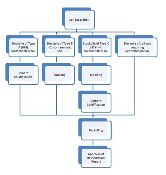
A review of ground decontamination options has been conducted in the Remediation Action Plan (RAP) in Appendix 7.2. In summary, from this review the following ground decontamination methods are recommended:
¡ Type A contaminated soil (Heavy Metals): Cement solidification, test, on-site backfilling.
¡ Type B contaminated soil (Hydrocarbons): Biopiling, test, on-site backfilling.
¡ Type C contaminated soil (Heavy Metals and Hydrocarbons): Biopiling followed by cement solidification, test, on-site backfilling.
The contaminated soil would be excavated and transported to the corresponding designated areas on-site for appropriate ground decontamination. Trucks would carry the excavated contaminated soil into the stockpiling areas or decontamination works areas for temporary storage or treatment respectively. Graphic 7.1 indicates the workflow during ground decontamination works.
Graphic 7.1: Flow Chart for Ground Decontamination Works
|
|
A schematic layout of a typical arrangement for all the works including excavation, cement solidification plant, biopile and stockpiling areas for different types of soil is shown in Graphic 7.2.
Graphic 7.2: Schematic Diagram of Typical Site Layout
|
|
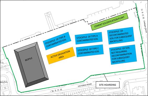
Table 7.3 summarises the excavation and decontamination volumes at the Kennedy Town CDA site under the proposed land use scenarios. Although three different Reprovisioning Options to conduct the proposed decontamination works have been devised, the volumes presented below are expected to remain the same under each Reprovisioning Option.
Table 7.3: Volumes of Contaminated Soil Requiring Excavation and Decontamination, and of Concrete Slab Requiring Demolition and Reuse/Disposal
|
|
Land Use Scenario |
|
|
|
|
Urban Residential / Rural Residential (m3) |
Public Parks / Industrial (m3) |
Total (m3) |
|
Excavated Soil Volume * |
151,178 |
26,967 |
178,145 |
|
Decontaminated Soil Volume |
|
|
|
|
Type A |
46,218 |
11,036 |
57,254 |
|
Type B |
14,690 |
2,543 |
17,233 |
|
Type C |
37,540 |
639 |
38,179 |
|
Total Decontamination Volume |
98,448 |
14,218 |
112,666 |
|
Concrete
Slab Volume |
6,369 |
1,898 |
8,267 |
Note: * = excluding concrete slab volume.
Type
A = soil contaminated with Heavy Metals
(M).
Type
B = soil contaminated with Hydrocarbons
(HC).
Type
C = soil contaminated with both M and
HC.
Detailed procedures shall be formulated by the Contractor in a method statement to address all decontamination arrangements.
7.8
Mitigation of Adverse Environmental,
Health and Safety Impacts
Potential environmental, health and safety risks which may arise are identified and the recommended control/mitigation measures to be taken by on-site personnel during the carrying out of the Project (including excavation and ground decontamination, EM&A and other monitoring and measurement activities as required).
7.8.1
Health
and Safety
Identification of Risks and Migration Pathways
Project site activities may give rise to the
following health and safety risks to on-site personnel:
¡ Skin contact with contaminated soil, groundwater and wastewater;
¡ Exposure to or inhalation of potentially hazardous gases (such as VOCs) during excavation or formation/operation of biopile; and,
¡ Dust emissions from dry exposed stockpiles or cement solidification activities.
Contamination migration mechanisms and pathways include but are not limited to transport between groundwater, free product (if any), subsurface soil, surface soil, soil gas and indoor/outdoor air. Exposure pathways by receptors include ingestion, inhalation and dermal (skin) absorption.
Ingestion included intake of the Chemicals of Concern (COCs) via soil / groundwater ingestion. Inhalation refers to breathing of release COCs (essentially as vapour or respirable suspended particulates from soil / groundwater to indoor/outdoor air. Dermal absorption means COC intake through skin contact with COC-containing media. However, it should be noted that dermal contact and soil ingestion would not be valid pathways for off-site sensitive receivers.
Identification of Sensitive Receivers
Within the Project site area, construction workers are the most likely to be exposed to any potential contaminated materials in the areas identified as containing contaminated materials. The principal exposure pathways for workers include:
¡ Direct ingestion of contaminated soils through eating, drinking or smoking on site; and
¡ Dermal (skin) contact with contaminated soils.
Through proper implementation of occupational health and safety guidelines and correct usage of personal protective equipment (PPE) (see discussion below), these potential pathways can be successfully managed.
Other sensitive receivers during the decontamination works may include the general public and other off-site human receptors as appropriate. The health impact assessment for the off-site human receptors is conducted in Section 3.
Identification of Preventive Measures
In order to minimise the potentially adverse effects on health and safety of site workers during the course of this Project, the Occupational Safety and Health Ordinance (Chapter 509) and its subsidiary Regulations shall be followed by all site personnel working on the site at all times. In addition, the following basic health and safety measures should be implemented as far as possible:
Maintain a hygienic working environment, including the provision of personal cleaning facilities;
¡ No food or drink is allowed in active excavation or ground decontamination works areas;
¡ Set up a list of safety measures for on-site personnel;
¡ Provide written information and training on safety for on-site personnel;
¡ Provide first aid training and materials to site workers;
¡ Keep a log-book and plan showing the contaminated zones and clean zones;
¡ Avoid dust generation;
¡ Direct skin contact with excavated soil, groundwater and wastewater should be avoided;
¡ Provide all necessary PPE to on-site personnel (e.g. chemical resistant jackboot, liquid tight gloves, face and respiratory protection gear);
¡ Washing facilities should be provided for on-site personnel, with site runoff produced directed to proper on-site treatment facilities; and
¡ Bulk earth moving equipment shall be utilised as much as possible to minimise manual handling and contact of contaminated soil.
When all of the above measures are properly implemented, the risks to human health (in terms of both carcinogenic and non-carcinogenic risks) would be considered to be acceptable.
7.8.2
Environmental
During excavation, the Contractor shall take note of the following measures:
¡ Properly design and execute excavation profile;
¡ Fence off the contaminated area throughout the period of ground decontamination works;
¡ Take precautions when controlling ground settlement, groundwater and wastewater;
¡ Avoid temporary stockpiling as far as practical. In case temporary storage is needed, contaminated soil should be placed in designated area paved with either concrete or lined with impermeable sheeting, bunded and covered properly with tarpaulins to prevent cross-contamination of different types of contaminated soil;
¡ Supply of suitable backfill materials after excavation;
¡ Implement speed control for vehicles travelling on site;
¡ Properly decontaminate machineries and vehicles before excavating or taking different contaminated soil and leaving the excavation zone.
The following mitigation measures shall be followed during decontamination works:
¡ The loading, unloading, handling and storage of cement should be carried out in an enclosed environment;
¡ The loading, unloading, handling, transfer or storage of materials that may generate airborne dust emissions such as untreated soil and oversize materials sorted out from screening plant and stabilised soil stockpiled in designated area should be carried out in such a manner to prevent or minimise dust emissions.
¡ All practical measures, including but not limited to speed control for vehicles, should be taken to minimise dust emissions;
¡ Simultaneous operation of mixing facilities and other equipment shall be avoided as far as possible to minimise unnecessary generation of noise nuisance;
¡ Stockpile of untreated soil shall be covered as far as practicable;
¡ Treated oversize materials can be used as backfilling material for on-site backfilling. Sorted materials of size smaller than 5cm will be collected and transferred to the mixing plant for further decontamination;
¡ Treated soils can be broken down into suitable size for on-site backfilling purpose;
¡ Water used in installation of pipe piles should as far as practicable be recirculated after sedimentation. Excess wastewater should go through silt removal facilities before discharge. The Contractor would be required to obtain a license from EPD under the WPCO for discharge to the public drainage system.
¡ Housekeeping should be maintained at all times at the mixing plant as well as among other decontamination facilities;
¡ Visual inspection and rinsing (if needed) of any contaminated soil adhered on the broken concrete slab surface are recommended; and
¡ A
clear separation between treated and untreated materials is recommended.
Furthermore, physical separation of the temporary stockpiles of different types
of soils in clearly designated areas with appropriate signage and fencing
should be provided.
7.9
Evaluation of Residual Impact
In terms of identified soil contamination, the proposed ground decontamination methods would remove contaminated soils from the grid concerned by excavation, followed by decontamination and testing to meet the requisite RBRGs by the relevant method(s) stated in Section 7.7 and then on-site backfilling. After completion of soil decontamination, no residual impact in respect of land contamination on future users of the Study Area is anticipated. After the completion of the remediation of the contaminated soil at the Project site, Remediation Reports (RR) shall be prepared and submitted to EPD for approval. No construction works for permanent development of site should be carried out prior to the approval of RR for the associated area.
7.10
Environmental
Monitoring and Audit
Since bulk excavation of soil for decontamination is anticipated, environmental monitoring in relation to decontamination should be considered. Land contamination monitoring could be carried out in the form of regular site inspections. All related procedures and facilities in handling/storing chemicals and chemical wastes should be audited regularly to make sure they are in order and intact and reported in the Environmental Monitoring and Audit (EM&A) Reports as such.
7.11 Conclusion
The land contamination assessment has been carried
out which included a review of historical/current land uses, desktop review and
site inspection. Other relevant information was also collected from related
Government Departments during this assessment.
Based on the findings of the site appraisal on the
existing and historical land uses in the Study Area, the presence of potential
land contamination and groundwater impacts associated with the proposed Project
works has been identified and assessed. Areas within the Study Area with
contaminated soil exceeding certain RBRGs have been identified. Additional SI
has been identified and conducted, and the laboratory results are provided. The
estimated volumes of soil to be excavated and remediated/decontaminated are
calculated based on an evaluation of the results of the original EIA study SI,
previous SI and additional SI. Treatment of contaminated soil by cement
solidification and/or biopiling has been recommended,
depending on the types of contaminants found in the soil in each designated
grid.
Sensitive
receivers, health and safety risks and migration pathways associated with the
proposed decontamination works have been identified, and mitigation measures
for handling of contaminated materials and regular site audits are recommended
to minimise the potential adverse impacts on workers’ health and safety and
disposal of potential contaminated materials.
After the completion of the remediation of the contaminated soil at the Project site, RR shall be prepared and submitted to EPD for approval. No construction works for permanent development of site should be carried out prior to the approval of RR for the associated area.