|
Contents |
Chapter Title
Tables
Figures
Appendices
Appendix 11.1 Some Information Extracted from the Reassessment Study
Appendix 11.2 Kerosene Transport Route
Appendix 11.3 Photos of Kerosene Truck used by GFS
Appendix 11.4 Fault Tree Analysis
Appendix 11.5 Event Tree Analysis in OWTF2
Appendix 11.6 Population Considered in this Assessment
Appendix 11.7 Individual Risk Results
Appendix 11.8 Societal Risk Results
Appendix 11.9 Cumulative Risk Assessment Result
11 Impact of Hazard to Life
|
11.1
Introduction
This section presents the findings of the hazard assessment undertaken for the project. The hazard assessment includes an evaluation of the risk during construction and operation phases of the Project due to the transport, storage, and use of dangerous goods at the project site as well as at hazard facilities in the vicinity of the project.
Kong Nga Po (KNP) in the North District is a rural area with limited existing developments. Part of the area falls within the Frontier Closed Area (FCA). There are villages lying at the far north and east. The major vehicular access to the Development Area is by a sub-standard rural track namely Kong Nga Po Road leading from Man Kam To Road. The Development Area can also be accessed from the east through Kong Nga Po Road and Ping Che Road.
The Project consists of site formation works and building works for the co-location of various police facilities in the Project site at Kong Nga Po as well as road improvement works to a section of the existing Kong Nga Po Road between the police facilities and Man Kam To Road. The police facilities include:
¡ Lo Wu Firing Range (LWFR) to be relocated from Lo Wu;
¡ Ma Tso Lung Firing Range (MTLFR) to be relocated from Ma Tso Lung;
¡ Weapons Training Facilities (WTF) and Police Driving and Traffic Training Facilities (PD&TTF) to be relocated from Fan Garden;
¡ Helipad to be relocated from Lo Wu;
¡ A Proposed Police Training Facility (PTF); and
¡ A new internal access road network with underpass within the Project site.
The improvement works to Kong Nga Po Road between the police facilities and Man Kam To Road includes roadworks, viaduct of less than 100m between abutments, and associated works such as slopeworks and retaining walls.
In addition to the above, associated supporting infrastructure and utilities including an underground stormwater storage tank, sewage pumping station, petrol / diesel filling station, a multi-storey training complex associated with the PD&TFF, and other ancillary facilities will also be provided.
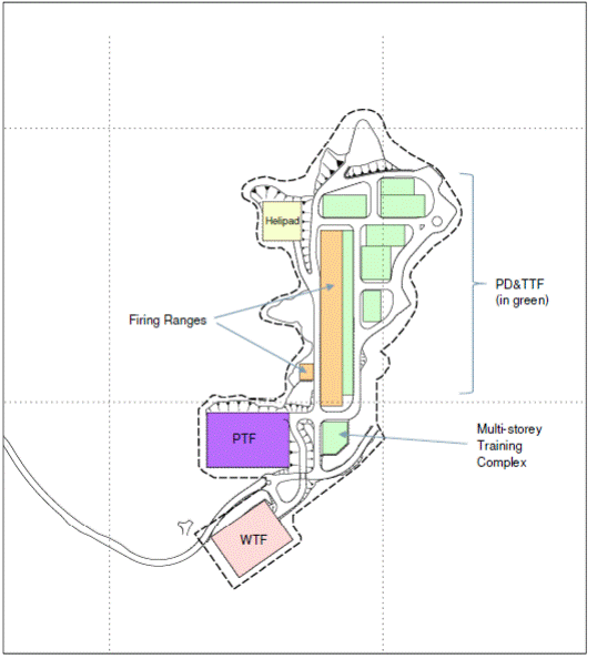
Since the project is a Designated Project as specified in Environmental Impact Assessment Ordinance (EIAO), an environmental impact assessment study is required to be carried out and Environmental Protection Department (EPD) has issued an EIA study brief (ESB-276/2014) for this project. According to this study brief, a Hazard to Life assessment has to be carried out to assess the potential hazard of Sheung Shui Water Treatment Works (SSWTW), Organic Waste Treatment Facilities Phase 2 (OWTF2), helicopter refuelling operation and other Dangerous Goods to be stored and used in the proposed site. The detailed layout within the proposed site is shown in Figure 11‑1.
This HA aims to achieve the objectives specified in the Section 2.1 of the EIA Study Brief. Technical requirements in the Study Brief are listed as follows:
3.4.10 Hazard to Life
3.4.10.1 The Applicant shall follow the criteria for evaluating hazard to life as stated in Annexes 4 of the TM.
3.4.10.2 The hazard assessment for the construction and operation of the Project shall follow the detail technical requirements to evaluate risks include the following:
1. Impacts from nearby Potentially Hazardous Installation (PHI)
The Applicant shall carry out hazard assessment to evaluate risk due to transport, storage and use of chlorine associated with the operations at Sheung Shui Water Treatment Works during the construction and operation of the Project. The hazard assessment shall include the following:
(i) Identify hazardous scenarios associates with the transport, storage and use of chlorine and then determine a set of relevant scenarios to be included in a Quantitative Risk Assessment (QRA)
(ii) Execute a QRA of the set of hazardous scenarios determined in (i), expressing population risks in both individual and societal terms
(iii) Compare individual and societal risks with the criteria for evaluating hazard to life stipulated in Annex 4 of the TM; and
(iv) Identify and assess practicable and cost-effective risk mitigation measures
2. Helicopter Fuel Refuelling and other Dangerous Goods (DGs)
If Helicopter Fuel Refuelling facilities and other dangerous goods (DGs) facilities are to be established in the Project site, the Applicant shall carry out hazard assessment as follows:
i. Identify hazardous scenarios associates with the transport, storage and use of helicopter fuel and other DGs and then determine a set of relevant scenarios to be included in a Quantitative Risk Assessment (QRA)
ii. Execute a QRA of the set of hazardous scenarios determined in (i), expressing population risks in both individual and societal terms
iii. Compare individual and societal risks with the criteria for evaluating hazard to life stipulated in Annex 4 of the TM; and
iv. Identify and assess practicable and cost-effective risk mitigation measures
3. The hazard assessment shall also include a cumulative risk assessment of the Project, through interaction or in combination with other existing, committed and planned developments involving hazardous facilities in the vicinity of the Project (e.g. Organic Waste Treatment Facilities Phase 2)
4. The methodology of hazard assessment shall be agreed with the Director and be consistent with previous studies having similar issues (e.g. North East New Territories New Development Areas, Permanent Aviation Fuel Facility of Hong Kong International Airport, Organic Waste Treatment Facilities Phase 2).
Figure 11‑1: Detailed location arrangement inside the proposed site
11.1.1
Study Approach
11.1.1.1
Overview
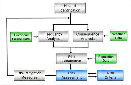
The overall approach to the assessment is represented in Figure 11‑2 below.
When conducting the HA reference to studies of similar nature or facility in Hong Kong were made, so as to maintain consistency with similar studies in Hong Kong. The studies reviewed were:
¡ In 2001, a study named the “Reassessment of Chlorine Hazard for Eight Existing Water Treatment Works: Hazard Assessment for Sheung Shui Water Treatment Works”[1]{, 2001, Reassessment of Chlorine Hazard for Eight Existing Water Treatment Works: Hazard Assessment for Sheung Shui Water Treatment Works} (hereinafter refer to as “the Reassessment Study”) was conducted. Hazardous scenario identified and assessed in the Reassessment Study will be adopted as a basis for the current HA.
¡ “North East New territories New Development Areas Planning and Engineering Study – Investigation” EIA report (NENT NDA EIA report), which has been approved in Oct 2013, included a detailed study on the Sheung Shui Water Treatment Works and the effects on the New Development Area on the risk level. Major assumptions including population projection will be adopted from this study.[2]
¡ An EIA study named “Development of Organic Waste Treatment Facilities, Phase 2”[3] (OWTF2 EIA) has been conducted and approved in year 2013. The hazardous scenario, process details etc. will be adopted and used in this report.
¡ Hazard scenarios and frequencies adopted in the Reassessment Study will be confirmed independently using review of historical incidents as instructed by the Court of Final Appeal (CFA) [4]. Accident databases were reviewed in this HA.
¡ The EIA study for South Island Line (East) in year 2010 prepared by MTR Corporation Limited has considered hazardous scenarios for road tanker transport of LPG. It will be referenced to derive the failure scenario for kerosene tanker transport for the helicopter refilling operation in the proposed facility.
¡ The EIA for the proposed 3-runway system in Hong Kong International Airport (“Expansion of Hong Kong International Airport into a Three-Runway System”[5]), which has been approved in year 2014, has assessed the risk of Jet A1 kerosene (the same fuel used by the helicopter in the proposed police facility) as well as the risk of petrol refilling. The methodology will be referenced and adopted in this HA.
¡ With regard to the assessment of impact of chlorine release on the transient population (on road and railways), the approach as documented in the HSE study “The implication of major hazard sites in close proximity to major transport route”[6] will be adopted. As for other populations, consideration is given for the possibility of escape from the toxic cloud, protection of the buildings, and higher fatality rate of sensitive groups. This methodology was also adopted in the previous Reassessment Study.
The major phases in the HA are:
Hazard Identification: Identify hazard scenarios associated with the transport, storage and use of chlorine, helicopter fuel and other DGs, and then determine a set of relevant scenarios to be included in a QRA.
Frequency Assessment: Assess the likelihood of occurrence of the identified hazard scenarios.
Consequence Assessment: Assess the consequences and impact to the surrounding population.
Risk Summation and Assessment: Evaluate the risk level, in terms of individual risk and societal risk. The risks will be compared with the criteria stipulated in Annex 4 of the Environmental Impact Assessment Ordinance – Technical Memorandum (EIAO-TM) [7] to determine their acceptability.
Identification of Mitigation Measures: Identify and assess practicable and cost-effective risk mitigation measures. The risks of mitigated cases will then be reassessed to determine the level of risk reduction.
11.1.1.2
Risk Acceptability Criteria
As stipulated in Annex 4 of the EIAO-TM, the risk guidelines comprise two measures shown as follows:
Individual Risk: the maximum level of off-site individual risk should not exceed 1 x 10⁻⁵ / year, i.e. 1 in 100,000 per year.
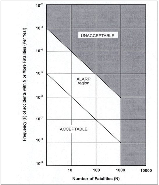
Societal Risk: it can be presented graphically as in Figure 11‑3. The Societal Risk Guideline is expressed in terms of lines plotting the frequency (F) of N or more fatalities in the population from accidents at the facility of concern. In the figure, ALARP means As Low As Reasonably Practicable. Risk in this region should be mitigated to As Low As Reasonably Practicable.
Figure 11‑3: Societal Risk Guidelines
11.1.2
Basis of Assessment
11.1.2.1
Cases to be assessed
Population in the vicinity is expected to increase with the development of NDAs, OWTF2, Shek Wu Hui Sewage Treatment Works extension, etc. For this study, the situation of year 2023 and 2032 will be accessed. Year 2021 is the final year of construction of this Project, but year 2023 will be used so as to align with the NENT NDA EIA assumptions; while at year 2032 the site development of NDA will be completed and fully occupied.
Major construction work within 1 km CZ of SSWTW includes sewage plant extension and NDA. More population (construction workers) may be present during the construction stage than the working staff during operation at the sewage treatment works extension. Thus consideration will also be given to the construction stage at Year 2021.
Four cases will be considered in this study to evaluate the changes in risk level caused by the proposed development:
Calibration Case (year 2006)
“Planned population” at 2006 (from the Reassessment Study). In this calibration exercise, input data used in the Reassessment Study will be adopted to verify the outputs from the current risk model RISKSUM are consistent with previous results. This exercise has been performed in the NENT NDA EIA report and approved by EPD. Exactly the same RISKSUM code will be adopted in this study for the simulation of chlorine hazard.
Baseline without proposed Project (year 2032)
The “Baseline” case assumes that the proposed police facilities will not be relocated to Kong Nga Po, i.e. the original plan in NENT NDA EIA report will remain unchanged. It is used to demonstrate the risk level without the proposed project. Population will be updated to reflect the latest information available on the situation in year 2032.
Construction Stage (year 2021 – Based on year 2023 NDA scenario)
In year 2021, the proposed project will be in last year of construction stage. Construction workers will be present in the site which will be assumed to be 100% outdoor. This case will reflect the risk level due to the construction work of the project. As the population of the area is generally increasing (more explanation in Section 11.2.1.3 and Section 11.2.1.6), choosing the last year of construction stage is a conservative approach.
In order to produce a more comparable result with previous reports, the population assumption of year 2023 in NENT NDA EIA report will be adopted. Detail explanation are provided in Section 11.2.1
Operation Stage (year 2032)
The proposed police facility will be in operation in year 2022. However, in order to reflect the final situation of risk level due to the police facility as well as the NENT NDA development, situation in year 2032, of which the NENT NDA development will be completed and expected to be fully occupied, will be adopted. This case will reflect the operation stage risk level of the development.
11.1.2.2
Review of SSWTW Facilities
Site visit to SSWTW facilities was conducted on 29th June 2015. It was confirmed with WSD that there is no major change in process, inventory etc. from the NENT NDA EIA report. In addition, implementation of mitigation measures specified in the Reassessment was verified through site visit and interview:
¡ Road markings within the roads in SSWTW – these features are implemented in the SSWTW (Figure 11‑4)
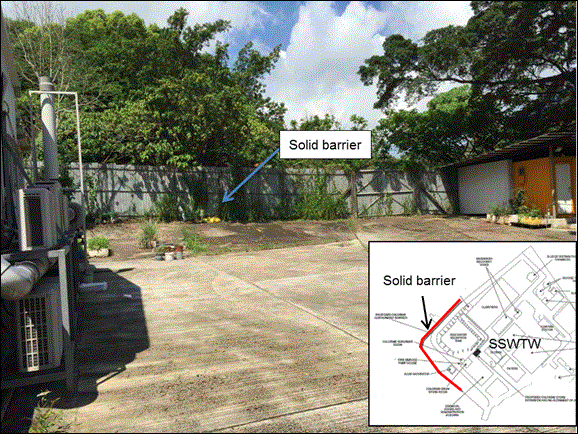
¡ Barrier in the north-west boundary of SSWTW – these features are implemented in the SSWTW (Figure 11‑5)
Figure 11‑4: Road Markings within SSWTW
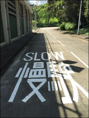
Figure 11‑5: Barrier in the north-western corner of SSWTW
11.1.2.3 Review of OWTF2
A letter has been sent to Environmental Protection Department (EPD) dated 21st May 2015 and EPD has confirmed that there will be no change in design and process from the OWTF2 EIA report. Failure scenarios and other simulation parameters in OWTF2 EIA report will be adopted in this report.
11.1.2.4
Proposed Police Facility in Kong Nga Po
Site visit to Lo Wu / Ma Tso Lung Firing range and Fan Garden Police Driving training and Weapon Training Facility was conducted on 25th June, 2015, which were the major facilities that will be co-located at the proposed Kong Nga Po site. Hazard scenarios and safety features of these facilities were discussed and incorporated in the study.
11.1.2.5
Meteorological Data
The meteorological conditions affect the consequence of release in particular the wind direction, speed and stability, which influence the direction and degree of turbulence of gas dispersion. For consistency, meteorological data used in the Reassessment Study will be adopted for Case 1 (model calibration) in this assessment. Data recorded at the Ta Kwu Ling weather station in 1996, are shown in Table 11‑1. For other cases, the average meteorological data recorded in 2011-2014 will be applied, as shown in Table 11‑2. The meteorological condition is similar to those in 1996, with prevailing wind direction from the east.
Table 11‑1: Meteorological Data (1996)
|
|
|
Probability |
||||||||
|
|
|
Day |
Night |
|
||||||
|
Wind Speed (m/s) |
2.5 |
2 |
4.5 |
1 |
1.5 |
4.5 |
1.5 |
|
||
|
Atmospheric Stability |
B |
D |
D |
F |
D |
D |
F |
Total |
||
|
Direction |
N |
0.0272 |
0.0269 |
0.0375 |
0.0104 |
0.0145 |
0.0235 |
0.0423 |
0.1823 |
|
|
NE |
0.0064 |
0.0052 |
0.0020 |
0.0028 |
0.0024 |
0.0019 |
0.0134 |
0.0341 |
||
|
E |
0.0624 |
0.0585 |
0.0805 |
0.0165 |
0.0254 |
0.0469 |
0.1338 |
0.4240 |
||
|
SE |
0.0089 |
0.0106 |
0.0035 |
0.0088 |
0.0082 |
0.0033 |
0.0672 |
0.1105 |
||
|
S |
0.0160 |
0.0137 |
0.0048 |
0.0057 |
0.0034 |
0.0006 |
0.0413 |
0.0855 |
||
|
SW |
0.0223 |
0.0093 |
0.0023 |
0.0033 |
0.0018 |
0.0001 |
0.0214 |
0.0605 |
||
|
W |
0.0184 |
0.0045 |
0.0005 |
0.0021 |
0.0029 |
0.0000 |
0.0189 |
0.0473 |
||
|
NW |
0.0138 |
0.0122 |
0.0028 |
0.003 |
0.0073 |
0.0006 |
0.0161 |
0.0558 |
||
|
Total |
0.1754 |
0.1409 |
0.1339 |
0.0526 |
0.0659 |
0.0769 |
0.3544 |
1 |
||
Figure 11‑6: Wind rose adopted in this study (2011-2014 average)
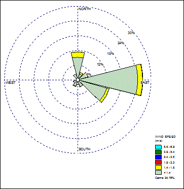
Table 11‑2: Meteorological Data (2011-2014 average data)
|
Day |
||||||||
|
Wind Speed (m/s) |
2.5 |
1.5 |
3.5 |
7.0 |
2.5 |
1.5 |
||
|
Atmospheric Stability |
B |
D |
D |
D |
E |
F |
Total |
|
|
Direction (Degree) |
0 |
0.0928 |
0.0149 |
0.0217 |
0.0016 |
0.0095 |
0.0280 |
0.1684 |
|
30 |
0.0264 |
0.0084 |
0.0056 |
0.0009 |
0.0021 |
0.0086 |
0.0521 |
|
|
60 |
0.0461 |
0.0070 |
0.0019 |
0.0004 |
0.0025 |
0.0081 |
0.0660 |
|
|
90 |
0.2146 |
0.0312 |
0.0360 |
0.0024 |
0.0157 |
0.0271 |
0.3270 |
|
|
120 |
0.0585 |
0.0180 |
0.0175 |
0.0009 |
0.0081 |
0.0205 |
0.1234 |
|
|
150 |
0.0228 |
0.0067 |
0.0015 |
0.0001 |
0.0019 |
0.0097 |
0.0427 |
|
|
180 |
0.0217 |
0.0059 |
0.0013 |
0.0000 |
0.0011 |
0.0065 |
0.0366 |
|
|
210 |
0.0425 |
0.0063 |
0.0029 |
0.0001 |
0.0003 |
0.0048 |
0.0568 |
|
|
240 |
0.0332 |
0.0043 |
0.0010 |
0.0001 |
0.0005 |
0.0030 |
0.0420 |
|
|
270 |
0.0122 |
0.0017 |
0.0000 |
0.0000 |
0.0001 |
0.0019 |
0.0158 |
|
|
300 |
0.0127 |
0.0025 |
0.0004 |
0.0000 |
0.0004 |
0.0038 |
0.0198 |
|
|
330 |
0.0304 |
0.0063 |
0.0019 |
0.0000 |
0.0019 |
0.0093 |
0.0497 |
|
|
Total |
0.6138 |
0.1129 |
0.0916 |
0.0065 |
0.0441 |
0.1312 |
1.0000 |
|
|
Night |
||||||||
|
Direction (Degree) |
0 |
|
|
0.0364 |
0.0019 |
0.0211 |
0.1425 |
0.2038 |
|
30 |
|
|
0.0077 |
0.0005 |
0.0085 |
0.0241 |
0.0416 |
|
|
60 |
|
|
0.0038 |
0.0005 |
0.0038 |
0.0403 |
0.0484 |
|
|
90 |
|
|
0.0389 |
0.0011 |
0.0636 |
0.1535 |
0.2582 |
|
|
120 |
|
|
0.0307 |
0.0005 |
0.0414 |
0.1450 |
0.2176 |
|
|
150 |
|
|
0.0005 |
0.0000 |
0.0025 |
0.0781 |
0.0811 |
|
|
180 |
|
|
0.0000 |
0.0000 |
0.0014 |
0.0556 |
0.0575 |
|
|
210 |
|
|
0.0014 |
0.0000 |
0.0041 |
0.0299 |
0.0354 |
|
|
240 |
|
|
0.0000 |
0.0000 |
0.0008 |
0.0156 |
0.0164 |
|
|
270 |
|
|
0.0000 |
0.0000 |
0.0003 |
0.0096 |
0.0102 |
|
|
300 |
|
|
0.0003 |
0.0000 |
0.0003 |
0.0096 |
0.0107 |
|
|
330 |
|
|
0.0014 |
0.0000 |
0.0025 |
0.0140 |
0.0190 |
|
|
Total |
|
|
0.1211 |
0.0045 |
0.1503 |
0.7178 |
1.0000 |
|
11.2
Population Adopted For the Assessment
11.2.1
Surrounding Population
11.2.1.1 General Approach
Population data to be considered included the 2006 “planned population” from the Reassessment Study (for the calibration case), existing population around SSWTW, future NDAs population, and population around OWTF2, which may be affected by the hazardous scenarios of SSWTW, OWTF2 and proposed police facility.
The population data considered in this study is all population within the 1km Consultation Zone (CZ), as well as population outside the CZ which might be affected by potential chlorine releases. Since hazards from OWTF2 are also considered in this study, the population at the vicinity of OWTF2 will also be considered. The population area considered in this study is illustrated in Appendix 11.6.1.
Estimation of future population is based on the following sources:
¡ Assumptions made in NENT NDA EIA report
¡ Assumptions made in OWTF2 EIA report
¡ Data from other departments such as CEDD
¡ For other areas surrounding the SSWTW (especially existing Sheung Shui development), the figures are based on the 2011 Population Census from the Census and Statistics Department (C&SD), and other available information sources. An average annual growth rate was adopted to project the future population at these surrounding areas of SSWTW.
¡ For schools, kindergartens and elderly homes, information will be collected from the Education Bureau, Social Welfare Department and corresponding websites if updated information from NENT NDA EIA report is identified.
¡ Surveys undertaken by the consultants.
11.2.1.2 Proposed Police Facilities
(This Project)
Based on the data of the current facility, the number of staff and trainee for each facility in the site can be estimated and are summarized in the following table:
Table 11‑3: Population within the proposed site
|
Facility |
No. of Staff |
No. of Trainee |
|
PTF |
35 |
100 |
|
WTF |
35 |
100 |
|
Lo Wu Firing Range |
10 |
40 |
|
Ma Tso Lung Firing Range |
5 |
16 |
|
PD&TTF |
82 |
63 |
The total number of staff and trainee is 486. It is conservatively assumed to be 500 in this assessment. 400 construction workers are assumed to be on site during construction phase.
11.2.1.3
Existing Sheung Shui Population
The existing Sheung Shui population at base year and construction year is adopted from the NENT NDA EIA report using its year 2023 and year 2032 estimate. The population estimation is checked against the latest Outline Zoning Plan (OZP) map in Statutory Planning Portal (http://www2.ozp.tpb.gov.hk/) by the Town Planning Board and there is no major variation that may lead to under-estimation of population.
According to NENT NDA EIA report, all residential population in Sheung Shui area were assumed to grow in an annual growth rate of 1.1% counting from year 2011 “base year”.
Some of the site boundaries, such as Hung Kiu San Tsuen (SS_15), and Sheung Shui Wa Shan (SS_14) are slightly modified based on the latest OZP (Statutory Plan No. S/NE-FTA/14 – Fu Tei Au & Sha Ling).
11.2.1.4 New Development Area (NDA)
The Chief Executive announced in his 2007-08 Policy Address the development of New Development Areas (NDAs) as one of the ten major infrastructure projects for economic growth. The NDAs shall provide quality living space in the northern New Territories.
The Kwu Tung North (KTN) and Fanling North (FLN) NDAs have been studied in form of EIA and was approved in October 2013. In this study, the majority of population assumptions will be adopted from the NENT NDA EIA report.
Based on the NDAs implementation plan, site formation and construction at KTN and FLN areas will commence at year 2016, and the first population intake is scheduled at year 2023. In year 2023, population in new residential/commercial development areas of NDA Development Package 2 to 5 (KTN South, KTN North, FLN East and FLN West) would be conservatively assumed to be 50% of the planning population, following the assumptions in NENT NDA EIA report.
Site development will complete at year 2030 (early finish) for KTN and FLN areas near SSWTW, which may be delayed to year 2031 (late finish) considering potential project uncertainties.
In this assessment, the year 2023 case in NDA EIA report will be adopted in the construction case, while the year 2032 situation will be used in the operation case of this study.
Some changes in NDA population are adopted in this assessment. In the original NDA development plan, two areas (ID: FLN_A1_11 and FLN_A1_8) were reserved for Police Driving and Traffic Training and Weapon Training facility. Although now the facilities will be developed in Kong Nga Po, the two areas will remain to be government reserve pending further decision on future use. The population assumption will remain the same as NENT NDA EIA report.
The Hong Kong Police Force Border District Headquarters (ID: OWTF_4) was both mentioned in NENT NDA EIA report (ID: SS_J and with population of 150) and OWTF2 EIA (ID: 4 with population of 200). The population assumption used in OWTF2 EIA, which has more population than that of NENT NDA EIA report, was adopted for conservativeness.
11.2.1.5 Organic Waste Treatment
Facilities Phase 2 (OWTF2)
The Director of Environmental Protection proposes to construct and operate Phase 2 of OWTF in Sha Ling, North District. The main purpose of the Project is to adopt proven biological treatment technologies to recover reusable materials and energy, such as compost, heat, electricity and biogas from source-separated organic waste which is currently being disposed of at landfills.
Based on the communication with EPD, the latest development schedule of OWTF2 is as follows:
Table 11‑4: Latest Schedule of OWTF2
|
Phase |
Year |
|
Start of construction |
2017 |
|
Start of operation |
2020 |
The appropriate population and indoor/outdoor ratio will be assigned to the OWTF2 facilities based on the latest schedule. The situation of later years, with OWTF2 in operation and generate extra risk due to the presence of biogas storage, will also be considered in the risk summation.
11.2.1.6
Frontier Closed Area (FCA) Development
In the OWTF2 EIA report, assumption was made for the Man Kam To Development Corridor (ID: 20 in OWTF2 EIA), Kong Nga Po Comprehensive Development Area (ID: 18 in OWTF2) and Hung Lung Hang Residential Development (ID: 19 in OWTF2 EIA). However, up till present there is no indication that the development will be confirmed in the near future. The population in that area is thus assumed based on the currently available Outline Zoning Plan. In OWTF2 EIA report it was also assumed there will be a Sandy Ridge Crematorium and Columbarium (C&C) Facilities (ID: 21 in OWTF2 EIA) in the future. The population assumption in OWTF2 EIA will be followed in this study.
11.2.1.7 Residential Area near OWTF2
For residential population areas near OWTF2, an annual growth rate of 2.5% from year 2017 (the year specified in OWTF2 EIA report) to year 2023 were assumed, which is based on “Projection of Population Distribution 2014-2023” by C&SD.
11.2.1.8 Summary
Table 11‑5 summarized the change of major population groups in this study:
Table 11‑5: The change of major population group in consultation zone
|
Year |
NDA |
OWTF |
Kong Nga Po |
Existing Sheung Shui Town area |
|
2017 |
Construction |
Construction |
Rural Development |
Normal Population Growth |
|
2018 |
Construction |
Construction |
Rural Development |
Normal Population Growth |
|
2019 |
Construction |
Construction |
Construction |
Normal Population Growth |
|
2020 |
Construction |
Operation |
Construction |
Normal Population Growth |
|
2021 |
Construction |
Operation |
Construction |
Normal Population Growth |
|
2022 |
Construction |
Operation |
Operation |
Normal Population Growth |
|
2023 (Construction Case) |
Half development* |
Operation |
Operation (assuming construction population) |
Normal Population Growth |
|
2024 |
Half development* |
Operation |
Operation |
Normal Population Growth |
|
2025 |
Half development* |
Operation |
Operation |
Normal Population Growth |
|
2026 |
Half development* |
Operation |
Operation |
Normal Population Growth |
|
2027 |
Half development* |
Operation |
Operation |
Normal Population Growth |
|
2028 |
Half development* |
Operation |
Operation |
Normal Population Growth |
|
2029 |
Half development* |
Operation |
Operation |
Normal Population Growth |
|
2030 |
Half development* |
Operation |
Operation |
Normal Population Growth |
|
2031 |
Half development* |
Operation |
Operation |
Normal Population Growth |
|
2032 (Operation Case) |
Full development |
Operation |
Operation |
Normal Population Growth |
11.2.2 Variation of Population
The population may vary within the day. To account for this, the time period distributions extracted from Table I3 of Annex I of the Reassessment Study report (reproduced in Table 11‑6), will be adopted. A “jammed peak” period is considered for major highways representing the probability of standstill, “bumper-to-bumper” conditions in one traffic direction.
Table 11‑6: Definition of Time periods
|
Time Period |
Mon – Fri |
Sat |
Sun |
% Distribution |
|
Peak |
18.75 hr |
3.75 hr |
0 hr |
13.39% |
|
Jammed Peak |
1.25 hr |
0.25 hr |
0 hr |
0.89% |
|
Working Day |
40 hr |
4 hr |
0 hr |
26.19% |
|
Weekend Day |
0 hr |
4 hr |
12 hr |
9.52% |
|
Night |
60 hr |
12 hr |
12 hr |
50.00% |
11.2.3
Indoor Fraction
Each population is assigned with an indoor fraction which indicates the portion of population which can receive extra protection by staying indoor. The indoor fraction used in this study generally followed the assumption of the NENT NDA EIA and OWTF2 EIA based on the population type. For the residential population around OWTF2, the indoor fraction of 0.9 is assumed based on OWTF2 EIA report instead of 0.99 which has been adopted in NENT NDA EIA report. It can provide a more comparable result with previous report and it is more on the conservative side.
11.2.4 Transient Population
Traffic population considered in this study included population on those from the roads and railways. The locations of these roads and railway are indicated in Appendix 11.6.9.
Population associated with the road vehicles will be modelled as 100% outdoor, which is consistent with the Reassessment Study.
The transient population within the consultation zone, which is similar to residential population, is greatly influenced by the future development plan of the area, including the NENT NDA development as well as the potential development of the Closed Area. Since NENT NDA plan has already been approved, the transient population assumption in NENT NDA EIA report will be adopted as far as possible. Some other roads that are closer to the borders (e.g. Man Kam To Road, Kong Nga Po Road and the Sha Ling Road) will be analysed separately and described in the following sections.
11.2.4.1 Road Traffic in Sheung Shui Town area and NDA
NDA traffic forecast data will be adopted from NENT NDA report. Traffic during daytime non-peak hours and night are taken as 88.98% (=5.542/6.229) and 41.92% (=2.611/6.229) of peak hour traffic. Traffic variation is estimated from some major traffic stations in New Territories (Table 11‑7).
Table 11‑7: Traffic Variation at Different Time Periods at Major Traffic Stations (ATC 2014)
|
|
Average Hourly Traffic / Daily Traffic(1), % |
||
|
Station |
Peak |
Day |
Night |
|
S5001 Tuen Mun Rd |
5.999 |
5.540 |
2.572 |
|
S5003 Fanling Highway |
5.942 |
5.682 |
2.491 |
|
S5006 Ting Kok Rd |
6.799 |
5.583 |
2.345 |
|
S5008 Yuen Long Tai Yuk Rd & Kau Yuk Rd |
6.122 |
5.271 |
2.904 |
|
S5009 Kwong Fuk Rd |
5.914 |
5.335 |
2.869 |
|
S5011 Wang Chau Rd |
6.150 |
5.439 |
2.835 |
|
S5019 Castle Peak Rd – Yuen Long |
6.390 |
5.762 |
2.466 |
|
S5025 Yuen Long Highway |
6.517 |
5.727 |
2.409 |
|
Average |
6.229 |
5.542 |
2.611 |
Note: (1) Estimated from the Figures “Traffic flow variation and growth” of corresponding traffic stations
Average vehicle occupancy is 1.8 persons per vehicle at Core Station S5003 (a section of Fanling Highway near Sheung Shui Railway Station) as estimated from Annual Traffic Census 2014. This occupancy is adopted for roads near SSWTW. The average traffic population is calculated from the following formula:
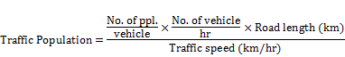
It is assumed vehicle speeds under normal traffic conditions are 50 km/hr and 70 km/hr for non-expressways and expressways respectively, according to the HK Road Traffic Ordinance. Vehicle speed during peak hours will be reduced due to traffic congestion, and assumed to be 35 km/hr[8]. In the jammed peak cases, roads are occupied by slow moving vehicles in one direction. Average vehicle speed in the jammed direction is assumed to be 5 km/hr, which is consistent with the observation from the traffic survey in the Reassessment Study (Population at jammed peak hours is 3.5 ~ 4 times of that at peak hours for Jockey Club Road).
11.2.4.2 Man Kam To Road (Population
ID: SS_P)
Man Kam To Road is the road connecting the Jockey Club Road and the Man Kam To Border Crossing Point (BCP) with single carriageway (2 northbound and 1 southbound lanes). Population assumption from NENT NDA EIA report (Population ID: SS-P) with additional load added to the operation phase to account for the increase in traffic in Kong Nga Po Road.
11.2.4.3 Kong Nga Po Road (Population
ID: OWTF_R2)
The traffic of Kong Nga Po Road is largely determined by a few user groups – present users including the villagers, police for assessing the Police Dog Unit and Force Search Unit Training School (Pop. ID: OWTF_1) and Hong Kong Police Force Border District Headquarters (Pop ID: OWTF_4), and also future users such as the OWTF2 and Hung Lung Hang Development Area. As a result, the traffic of Kong Nga Po road should not be estimated using general growth rate from Annual Traffic Census. The closest estimate available is the population estimate from OWTF2 EIA report, which was calculated based on the Traffic Impact Assessment of the OWTF2 Feasibility Study. It is the best available estimate and conservative because it has taken account for the traffic generated by OWTF2, and Kong Nga Po as a residential development.
During construction phase of the Project, It is assumed that there will be 40 construction workers working on the road for the road improvement work.
Extra 10% of traffic is added in the operation phase to account for the traffic generated by the police facilities.
11.2.4.4 Sha Ling Road (Population ID:
OWTF_R3)
The population of Sha Ling Road is assumed to be 10% of Man Kam To Road, which is in line with the assumption in OWTF2 EIA report.
11.2.4.5 Railway - East Rail and Lok Ma Chau Spur Line (Population ID: SS_R)
MTR East Rail network traverses the 1 km CZ of SSWTW. The minimum distance between the rail line and the WTW is about 90 m, at the west of SSWTW. From the Reassessment Study, the maximum exposure duration is estimated to be 1 min based on time for train to pass through chlorine cloud and time for chlorine to disperse from train afterwards. Transient population of the East Rail is considered as a source of traffic population. The population figure is adopted from the Reassessment Study, which has assumed the population using “crush-loaded” train with 3600 passengers per train, and divided by 10 to account for the limited exposure duration. Population is then further divided by length of train (300m) and multiplied by length of track within zone of interest (3.2km)
The Lok Ma Chau spur line is located outside of the CZ, at a distance of more than 1100 m and contained in an underground tunnel. Fatality due to exposure to the toxic cloud is not expected for the passengers on the spur line.
Apart from the original East Rail trains, the Intercity Through Train (ktt train) which runs between Hung Hom and Guangzhou will also use the same track and pass through the study zone. The ktt train has a maximum capacity of about 2200 (12 compartments * about 180 passengers per compartment, during full-load). It has a lower capacity than a “crush-loaded” train as assumed in Reassessment Report, hence it is conservative to use the population figure in Reassessment Report.
The approach employed in the Reassessment Study will be adopted in this assessment to estimate the affected population on trains by chlorine releases. The trains are much alike to the road vehicles, except that they are unlikely to come to a halt within a chlorine cloud. This means that the exposure of rail passengers to the released chlorine is limited to the duration for which the train is within the cloud plus the time for the chlorine to disperse from the carriages subsequently. Population is based on crush-loaded train but divided by factors to account for limited exposure duration and length of train, and multiplied by length of track within zone of interest.
11.2.4.6 Summary
The transient population considered in this study is summarized in Appendix 11.6.10.
11.3
Modelling Approach and Calibration
11.3.1
Modelling Approach of SSWTW
11.3.1.1
Proposed Risk Modelling Approach
This assessment will make use of the consequence modelling results in the Reassessment Study as well as the consultant’s in-house risk summation model, RISKSUM, to assess the level of risk.
For the toxic chlorine cloud dispersion upon an accidental release, cloud dispersion contours from consequence modelling results in the Reassessment Study will be adopted. The consequence modelling in Reassessment Study was based on:
¡ Wind tunnel simulation
¡ Computational Fluid Dynamics (CFD); and
¡ DRIFT Flat terrain dispersion modelling
Based on the wind tunnel data, factors are applied to scale up/down wind tunnel data for various release quantities, and wind speed. Horizontal scaling factor is obtained from the DRIFT flat terrain dispersion modelling results for release mass and a simple scaling factor of 0.7 is applied for wind speed 5ms-1[2]. Such scaling methods were employed in the Reassessment Study.
For “wind smoothing” purpose, cloud dispersion contours are re-generated every 10° in wind direction using the closest wind direction contour through rotational transformation.
Occurrence frequencies, population, wind speed and other parameters are then entered into RISKSUM for risk summation process to obtain the Individual Risk and Societal Risk and will be presented in Individual Risk Contour Plots and FN Curves respectively.
11.3.1.2
Calibration of Model for SSWTW
In order to ensure compatibility in using different models in evaluating the risk associated with the SSWTW, a calibration exercise is generally necessary.
The model calibration exercise is to calibrate RISKSUM against the results of the reassessment study for the Sheung Shui Water Treatment Works. The input parameters used in the calibration exercise are either the same as those used in the Reassessment Study, or generated by the same methodology adopted in the Reassessment Study. For example, weather data and base event frequencies are the same, while consequence contours were generated by the same wind tunnel testing results and scaling factors as described in the Reassessment Study.
Since exactly the same RISKSUM model as used in NENT NDA EIA will be adopted in this study, the calibration exercise for this study will be the same as the model calibration in NENT NDA EIA. Nonetheless, a model calibration case “Case 1”, which is identical to the one in NENT NDA EIA model calibration paper “Revised Technical Paper on Model Calibration for Hazard Assessment”, was attached in the methodology report for the sake of completeness. The calibration exercise demonstrated results generated by RISKSUM are consistent with the tool used in the previous Reassessment Study.
11.3.2
Risk Modelling Approach of OWTF2
Since EPD has confirmed that there is no change in process parameters for OWTF2, the general modelling approach in this study will follow OWTF2 EIA Hazard Assessment report. DNV Phast Risk version 6.7 will be used to carry out the consequence modelling and risk summation. Failure cases and their frequencies were be reviewed and updated accordingly if effect due to the construction and operation of the proposed police facility was identified.
11.3.3
Risk Modelling Approach of Police Facilities
Risk modelling was carried out for those hazardous scenarios identified. Depending on the findings from consequence analysis, only those scenarios that are able to cause off-site hazards will be considered in detail for frequency analysis and risk summation. DNV Phast and Phast Risk (version 6.7) will be used for consequence calculation and risk summation.
11.4
Hazard Identification
11.4.1
Risk Identification of SSWTW
11.4.1.1
Review of identified Hazards in SSWTW
To identify potential hazards associated with the storage, use and transport of chlorine in the SSWTW, hazards identified in the Reassessment Study will firstly be examined.
Major hazard categories identified in the Reassessment Study are listed below:
¡ Access Road;
¡ Container Handling;
¡ Containers in Storage;
¡ Connection and Disconnection of Chlorine Containers; and
¡ Chlorination System.
A total of 36 hazards identified during HAZOP study for SSWTW in the Reassessment Study were be reviewed (Ref.: Table 3.2a of the Reassessment Study). Related chlorine release scenarios developed from these hazards will be examined and confirmed valid for use in this HA.
11.4.1.2
Review of Past Incidents
A review on relevant historical incidents for SSWTW has been conducted extensively by previous approved reports[1]. Referring to recent EIA studies, review of past incidents was conducted to identify any new hazardous scenarios. In particular, the world wide accident database Major Hazard Incident Data Service (MHIDAS), was independently reviewed in order to update the Hazard Identification conclusions. However, only a few relevant chlorine incidents occurred worldwide since the previous review, and after examination of their nature was concluded that no revision of the previously identified hazard scenario is necessary.
The following reference data were searched and consulted in the previous 8 WTWs Reassessment Study:
¡ MHIDAS
¡ The Library and Information Services of the UK HSE (HSELine)
¡ Lees Loss Prevention in Process Industries[9]
¡ AQUALINE
¡ Chlorine Institute
¡ Chlorine Transport Risk Study, DNV Technica (1991); and
The search undertaken is for all incidents involving chlorine ‘drums’ or incidents occurring at Water Treatment Works.
The primary causes of worldwide chlorine release incidents identified from previous 8 WTWs Reassessment Study include:
¡ Equipment Failure
¡ Human Error
¡ Corrosion
¡ Fire/Overheating
¡ Contamination
¡ Road accident
¡ Marine Accident
¡ Rail accident
Since some of the database such as MHIDAS is no longer updated nor hosted by UK HSE, and in view of the fact that there is no change in operation and design of SSWTW since the Reassessment Study, the past incident search is deemed sufficient for the purpose of identifying accidents causes related to the operation of SSWTW.
11.4.1.3
Review of Existing Chlorine Facilities
Information regarding the latest chlorine facilities installed in the SSWTW has been gathered during site visit to the water treatment works in June 2015. During the visit, an interview has been conducted with operation staff to confirm the latest operation and safety practice in place in the water treatment works.
As advised by the water treatment works operator, the treatment throughput, dosage of chlorine and water storage of chlorine drums has not been changed from the Reassessment Study. The only change that will affect the hazard assessment is that the chlorine drums used in SSWTW are all “new” drums with only 1 fusible plug, instead of the “old” drums having 6 fusible plugs per drum.
The mechanical ventilation system and the chlorine scrubbing system installed provide controlled air circulation and treatment of air in case of chlorine release. These systems are designed to prevent chlorine gas escape from the storage area in case of leakage.
Emergency repair and stoppage kit manufactured to the specification of the Chlorine Institute is provided according to Fire Services Department’s (FSD) safety requirement.
11.4.1.4
Hazard Associated with Construction Works
Therefore, no adverse impact associated with construction activities to the chlorine storage and dosing system of the SSWTW is anticipated.
11.4.1.5 Hazard associated with
helicopter crash
In OWTF2 hazardous scenarios, accident associated with helicopter crash will be considered (Section 11.5.3.2) due to the fact that the OWTF2 site is relatively close to the helipad (about 400m). For SSWTW, the distance between the proposed helipad and the SSWTW chlorine store is about 2km, hence helicopter crash is not considered as a hazardous scenario in SSWTW
11.4.2 Risk Identification of OWTF2
11.4.2.1 Hazards identified in OWTF2
EIA report
Since EPD has confirmed that there will be no major change in process and design for OWTF2, the hazards identified in OWTF2 EIA report are still valid and were adopted in this study. These hazardous scenarios include:
¡ Rupture/leak of gasholder
¡ Rupture/leak of digester
¡ Rupture/leak of sulphur absorption vessels
¡ Rupture/Leak of aboveground inlet or outlet piping/ purification piping/pump/non-return valve / flange
¡ Discharge from safety valves due to overfilling
11.4.2.2 Additional hazards due to the
construction/operation of proposed police facilities
The shortest distance between OWTF2 and the proposed police facility exceeds 200m. The gate of OWTF2 will also be separated from the Kong Nga Po Road by a small road which is 100m in length. As a result it is safe to assume that even the worst case scenario during construction phase of the proposed police facility (e.g. falling of tower crane, traffic accident along Kong Nga Po Road etc.) will not cause any impact on OWTF2.
The presence of construction work/operation of proposed police facilities will be modelled as a strong ignition source for OWTF2 due to increased human activities and presence of vehicles. The ignition probabilities in OWTF2 is further discussed in Section 11.5.3.6.
11.4.3
Risk Identification of Proposed Police Facilities
A comprehensive risk identification exercise has been performed on 25th June 2015 together with firing range experts in HKPF and the personnel from Government Flying Service. The major potential hazardous scenario of the proposed facility has been discussed.
11.4.3.1
Weapon Training Facility (WTF)
The proposed WTF will be used for Method of Entry and other related training. Only physical method /apparatus, such as hydraulic cutter, will be used in the training (no explosives will be used).For indoor weapon training, only FX® rounds (fake bullets) will be used. The rooms are completely enclosed which can prevent the FX® rounds hurting anyone outside the facility.
No explosive substance / gunpowder etc. will be stored in WTF. Only gun-oil (a blend of non-volatile lubricants) and paints/solvents (for maintenance purpose) will be stored within WTF.
Gun-oil
Gun-oil is a blend of lubricating oil for lubricating guns. The expected inventory is 20 litres and it will be kept in separate plastic containers in store room. The gun-oil is stable and has low volatility and not able to cause any offsite hazard considering the storage quantity.
Paints and solvents
Paints and solvents are used for routine maintenance of the facility. The paints and solvents used are common commercial paints and solvents used include:
¡ Turpentine – It is kept in metal containers with total inventory of 50 litres. Turpentine is flammable and harmful by inhalation, in contact with skin and swallowed. The flash point of turpentine is about 40oC.
¡ Thinner – It is kept in metal containers with total inventory of 50 litres. It is flammable and harmful by inhalation. The flash point is below 23oC.
¡ Paint - It is kept in metal containers with total inventory of 50 litres. It is common paint available from non-specialist dealers.
Since the proposed storage quantities of the above chemicals have exceeded the Exempted Quantity specified in the Dangerous Good Ordinance, these chemicals will be stored in a designated Dangerous Goods (DG) Store following regulations and requirements from FSD. The DG store will be equipped with suitable fire-fighting equipment and fire alarm system, and access to the store will be controlled.
Possible hazardous scenarios for storage of flammable material in DG store (without considering the safety provisions of the DG store) includes:
¡ Spontaneous leak of one storage container
¡ Spontaneous rupture of one storage container
¡ Falling of one container on rack hitting another container, causing rupture of both containers
¡ External fire/lightning igniting the flammable liquid in DG store
Since all of these chemicals are only replenished very infrequently (normally once a year) and they are stored in separate small metal containers (a few litres per container), the transportation of these chemicals are unable to cause off-site impact.
Section 11.6.3.1 will discuss these scenarios and their maximum possible consequence.
11.4.3.2 Proposed Police Training
Facility (PTF)
The PTF comprises of classroom training facilities as well as other facilities for weapon training. Similar to WTF only FX rounds will be used in the facility. No DG will be stored in PTF.
11.4.3.3 Firing Range
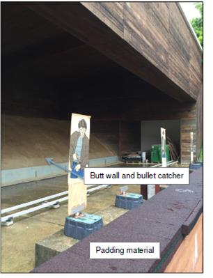
A 300m firing range (for relocation of Lo Wu Firing Range) and a smaller firing range (for relocation of Ma Tso Lung Firing Range) will be provided in the proposed facility. It will be used for training of handguns, rifles, shotgun etc.. No tear gas, high explosives, grenades, etc. will be used and stored in the range.
The firing range itself will be designed in JSP 403 standard, which is used in British Army. There are strict requirements on the design of bullet catcher and butt walls to prevent bullets from hitting anything outside of the range.
The proposed firing range will be a baffled range. The baffles are concrete structures covered with soft timber facing the shooter. The using of baffles will further prevent bullets leaving the range in high angle.
The firing range is strictly managed according to the Range Orders which is specific to each firing range.
The hard surface inside the range is covered with soft padding material (plastic or timber) which can avoid bouncing back of ricochet (Figure 11‑7).
Figure 11‑7: Padding material to prevent bouncing back of ricochet
|
|
Around 100 litres of paints and solvents will be stored in DG store in the range.
11.4.3.4
Police Driving and Traffic Training Facilities (PD&TTF)
The general properties of petrol and diesel can be summarized in the following table:
Table 11‑8: Physical Properties of petrol and diesel
|
Property |
Petrol |
Diesel |
|
General carbon chain number |
C4 – C12 |
C8 – C25 |
|
Liquid density |
718 – 778 kg/m3 (@ 15 oC) |
820 to 845 kg/m3 [10] |
|
Boiling Point |
~33 oC [11] |
180–340 oC [12] |
|
Minimum Flash Point |
-7 oC [12] |
55 oC[10] |
|
Flammable Limits |
Lean - 1.4 vol. %[11] Rich - 6.8 vol. %[11] |
Lean - 1.3% [13] Rich - 6% [13] |
|
Burning Rate |
0.27 (lb/ft2) |
0.22(lb/ft2) |
|
Minimum Ignition Energy |
0.29 (mJ)[12] |
0.23 (mJ) [12] |
|
Auto-ignition temperature |
371 oC [12] |
315 oC [12] |
|
Vapour Pressure |
43 mm Hg @ 20oC) [12] |
0.4 mm Hg @ 20oC [12] |
|
Viscosity |
0.5-0.6 mm2/sec @ 68 oF [12] |
2.00 – 4.5 mm2/sec (at 40 oC) [10] |
|
Latent heat of vaporisation |
~350 kJ/kg @60oC[12] |
~233 kJ/kg @60oC [12] |
|
Specific heat |
0.48 Btu/lb-oF [12] |
0.43 Btu/lb-oF [12] |
|
Heat of combustion |
25300-27600 (kJ/L @ 15oC) [12] |
26200-30400 (kJ/L @ 15oC) [12] |
The above table showed that petrol is generally more volatile and more easily get ignited when it is leaked, so in this assessment gasoline would be used to model diesel, which is a more simplified and yet conservative approach.
For the general operation of a petrol/diesel filling station, a few hazardous scenarios can be identified:
For hazardous scenario that can happen at all time:
¡ Leak/rupture of underground storage tank
¡ Leak of dispensers
Only during dispensing petrol/diesel to vehicles
¡ Rupture of flexible hose from dispenser to vehicles
¡ Rupture of fixed pipework from underground storage tank to dispensers
Only during refuelling of underground storage tanks
¡ Leak/rupture of the petrol/diesel road tanker
¡ Rupture of flexible hose / fixed pipework from petrol/diesel road tanker to underground storage tanks
The hazardous scenario for petrol/diesel road tanker transportation includes:
¡ Cold rupture/ partial failure of road tanker vessel
No vehicle maintenance work will be carried out in the PD&TTF.
PD&TTF stores diesel for emergency generator in the campus. The amount of diesel for the emergency generator is 150 litres. The diesel is stored in the emergency generator room / dangerous goods store which is secured by lock.
The hazardous scenario of diesel storage in DG store will be the same as those discussed in Section 11.4.3.1 for flammable liquid storage in DG stores.
11.4.3.5 Helipad and helicopter
refuelling operation
A helipad area will be constructed in the proposed police complex which will be used by both GFS and the police. Generally the helicopter will be refuelled in the GFS depot in Hong Kong International Airport (HKIA). Under some specific operational need refuelling operation may also be carried out in the helipad area.
The fuel used by helicopter is Jet A1, which is a kerosene-based liquid fuel commonly used in the aviation industry. In the Dangerous Goods Ordinance, Jet A1 is classified as Category 5 Cl. 2 with flash point of or exceeding 23oC but not exceeding 66oC. The chemical properties of Jet A1 are summarized Table 11‑9.
Table 11‑9: Properties of kerosene (Jet A1)
|
Property |
Value |
|
Liquid density |
775-850 kg/m3 @ 15oC[14] 840 kg/m3[14] |
|
Boiling Point |
150oC Initial[14] |
|
Minimum Flash Point |
38oC (40oC Test) [14] |
|
Flammable Limits |
1-6% vol. [14] |
|
Burning Rate |
0.053 kg/m2/s[14] |
|
Pool rate of flame spread |
<0.5 m/s[14] |
|
Auto-ignition temperature |
220oC[14] |
|
Minimum ignition energy |
0.2mJ[14] |
|
Vapour Pressure |
<0.1 kPa @ 20oC kPa[14] |
|
Viscosity |
1.4 x 10⁻³ kgm-1s-1[14] |
|
Latent heat of vaporisation |
291 kJ (based on kerosene Table C.1 of[15]) |
|
Specific heat |
2.19 kJ/kg (based on n-decane Table C.2 of [15]) |
Kerosene fuel, compared with another common type of aviation fuel known as AVGAS, is far less hazardous than other common fuels such as gasoline, due to its low volatility. At ambient temperatures, the vapour above a pool of kerosene will not be flammable. The liquid phase of the pool itself also cannot self-ignite or burn. It can be ignited by a strong ignition source such as a fire, but will not be ignited by a simple low energy ignition source such as a spark at the liquid surface, unless heated above 38oC[16].
Kerosene may be toxic by ingestion, but there is no acute toxic hazard of relevance to major accident scenarios considered here.
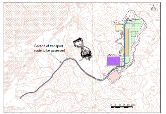
There will not be any kerosene storage tank in the proposed police facility. Kerosene road tanker (with a capacity of 3600 L) will travel to the police facility from GFS depot in Hong Kong International Airport (HKIA) upon request by GFS. The transport route is from North Lantau Highway and Lantau Link, Ting Kau Bridge, then via Tuen Mun Road and Yuen Long Highway on Route 9 to the proposed site at Kong Nga Po. It will take the same route back to GFS HQ without using any tunnel. Once arrived it will temporarily park near the helipad (not on the helipad) and wait for the helicopter to arrive. The off-site transport route from HKIA depot to the Project Site is illustrated in Appendix 11.2.
Once the helicopter arrives, the pilot will notify the kerosene road tanker driver to allow the road tanker to drive near the helicopter. Once ready, the flexible hose from the truck will be connected to the helicopter for refuelling.
During refuelling, there will be 3 staff on site – the pilot, the truck driver and a staff in charge of the safety. The kerosene pump is equipped with pressure switch to prevent overfilling of the helicopter. Firefighting equipment such as powder fire extinguisher will be available at the vicinity. EMSD will perform regular check on the road tanker and related equipment. There are rules for the pilot not to fly over the kerosene road tanker to prevent any possible incident of helicopter hitting the kerosene road tanker.
After the refilling operation, the road tanker will not serve other helipad and will drive directly back to airport GFS depot. On the return trip, there will be about 500L of kerosene reserve in the road tanker to cater for emergency situation.
Since kerosene has a relatively low electrical conductivity, static electricity may build up during transport and pumping, which may create sparks and ignite the fuel. The kerosene road tanker used by GFS is equipped with conducting wire that bonds the helicopter, the fuel nozzle and the road tanker itself. Clear procedure is in place to ensure all components are properly earthed before the fuel unloading operation. Photos of the kerosene road tanker focusing on the earthing equipment is shown in Appendix 11.3.
Refuelling will only be performed in daytime and takes place twice a month.
Considering the chemical properties of kerosene, low frequency of transport, well-developed safety procedure for kerosene road ranker operation, off-site transport of kerosene is generally not considered in similar hazard to life assessments of EIA studies in Hong Kong involving kerosene (Jet A1) [5, 16].
The transport route assessed in this study, which is valid for both kerosene and petrol/diesel, is shown in the following figure:
Figure 11‑8: Fuel road tanker transport route to be assessed
|
|
With reference to the SIL(E) EIA Report[17], the following hazardous scenario could be identified for road tanker transport of flammable liquid:
¡ Cold rupture of road tanker
¡ Cold partial failure of road tanker
¡ Rupture of flexible hose
¡ Leak of flexible hose
Since Jet A1 has a flash point as high as 37 deg C, flammable vapour cloud will not be formed in most circumstances. Thus in some of the scenario above such as the flexible hose failure, only an un-ignited pool will form due the lack of very strong ignition source, such as very hot surface or naked flame. Hence the consequence will be limited within the helipad and no off-site effect is envisaged. These scenarios were not further analysed or would be combined with other events with more severe consequences.
11.4.3.6 Review of past incident
involving kerosene
A search in MHIDAS database was performed using the keyword ‘kerosene’ in the ‘material name’ column and ‘transport’ in ‘origin’ column, 73 results were obtained from year 1886 to year 2005.
The following causes were identified:
¡ General Operational
¡ Ship/ship collision
¡ Rail Accident
¡ Corrosion
¡ High wind
¡ Sabotage
¡ External Explosion
¡ Excavation
¡ Ship to land collision
In view of the current setting of kerosene transport along a road, no new hazards are identified.
11.4.3.7 Review of past incident
involving petrol/diesel
A search in MHIDAS database was performed using the keyword ‘petrol’ in the ‘material name’ column and ‘the following keywords in ‘origin’ column, 118 results were obtained from year 1886 to year 2005.
¡ Transport
¡ Road tanker
¡ Storage
The following causes were identified:
¡ Road accident
¡ General maintenance
¡ General operational
¡ Rail accident
¡ High wind
¡ Sabotage
¡ External fire
In view of the current setting of petrol transport along a road and storage/use in a typical petrol filling stand, no new hazards are identified.
11.5
Frequency Assessment
11.5.1
General
With the potential hazards identified, the likelihood of each hazardous scenario will then be determined. The majority of the occurrence frequencies will be adopted directly from recent related studies, which will be supplemented by statistics from historical data if necessary. For some of the cases where historical accident data is not fully available or insufficient, a Poisson distribution can be assumed to derive the future occurrence rate of such events, by using the number of “no occurrences”. Or in other cases, Fault Tree Analysis technique can be used to derive the frequency using best available equipment failure data.
11.5.2 Frequency Assessment of SSWTW
In the Reassessment Study, frequencies of thirteen (13) selected scenarios have been developed. Failure rates from previous related studies and generic database (Table 5.2a of Reassessment Study report) were adopted to develop the events frequencies shown in Table 11‑10 (Table 5.2b of Reassessment Study report). These scenario frequencies will be adopted in this HA to assess the population risk. Adjustment on frequencies is considered due to the implementation of mitigation measures according to NENT NDA EIA report. The two mitigation measures identified includes (1) Provision of a containment barrier at northwest corner of SSWTW, which could eliminate the risk due to the event IU1TSRU (1-tonne internal instantaneous releases) and (2) Improvements to access road (marking and signage) to SSWTW, which could result in a reduction of 50% in frequency of truck-related accidents.
Another changes identified is the complete phase-out of “old” chlorine drums. Currently in all WTW only “new” drums are used which only have 1 fusible plug per drum, instead of 6 fusible plugs per drum in “old” drums. It is modelled by moving all the Truck Fire related accident frequencies to “RU1TMML” event. In Reassessment Study, there are three events that represent truck fire (Case 1.1 in Table 5.1a of Reassessment Study):
1. RU1TSRU –assuming two new drums, 1 old drums, equivalent to instantaneous release of 1 tonnes of chlorine on road.
2. RU1TMRU – assuming 3 old drums, equivalent to instantaneous release of 3 tonnes of chlorine on road.
3. RU1TMML – assuming 3 new drums, equivalent to medium leak of three drums.
Hence by moving the frequencies from RU1TSRU and RU1TMRU to RU1TMML, it effectively simulates the effect of phasing out the “old drums”.
Table 11‑10: Event frequencies with Implementation of Previous Identified Risk Mitigation Measures
|
Event Ref |
Component Scenarios |
Release Rate (or Quantity) to atmosphere |
Frequencies (per year) |
Time Period during which event could occur |
|
RU1TSML |
Rollover |
1.4kg/s |
5.20E-07 |
All except night |
|
|
Load-shedding |
|
1.27E-07 |
All except night |
|
|
Spontaneous leak |
|
1.03E-07 |
All except night |
|
|
Total |
|
7.50E-07 |
|
|
RU1TMML |
Rollover |
4.2kg/s |
3.83E-08 |
All except night |
|
|
Truck fire |
|
7.33E-08 |
All except night |
|
|
Total |
|
1.12E-07 |
|
|
RU1TSRU |
Truck Impact |
1 tonne |
1.25E-07 |
All except night |
|
|
Truck fire |
|
0.00E+00 |
All except night |
|
|
Spontaneous drum failure |
5.08E-08 |
All except night |
|
|
|
Total |
|
1.76E-07 |
|
|
RU1TMRU |
Truck fire |
3 tonnes |
0.00E+00 |
All except night |
|
EU1TMRU |
Earthquake |
10 tonnes |
3.30E-07 |
All |
|
EU1TMRUH |
Earthquake |
10 tonnes |
7.00E-08 |
All |
The frequencies of occurrence of hazard scenarios determined were used as input parameters for modelling using RISKSUM.
11.5.3
Frequency Assessment of OWTF2
11.5.3.1 Aircraft crash
The OWTF2 site is located around 32km from the Hong Kong International Airport. The frequency of aircraft crash is estimated using the HSE methodology, which is in line with approved “Kai Tak Development” EIA report [18, 19].
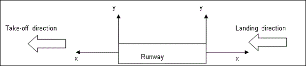
The model takes into account specific
factors such as the target area of the proposed hazard site and its
longitudinal (x) and perpendicular (y) distances from the runway threshold. The
crash frequency per unit ground area (per km2) is calculated as:
![]() (Equation 1)
(Equation 1)
Where N is the number of runway movements per year and R is the probability of an accident per movement (landing or take-off). FL(x,y) gives the spatial distribution of crashes and is given by:
For aircraft landing,
![]() (Equation 2)
(Equation 2)
For x > -3.275km
For aircraft take-off,
![]() (Equation 3)
(Equation 3)
For x > -0.6km
Equation 2 and Equation 3 are valid only for the specified range of x values. If x lies outside this range, the impact probability is zero. Aircraft Crash Coordinate System is shown in Figure 11‑9.
Figure 11‑9: Aircraft Crash Coordinate System
Updated worldwide aviation accident rate is obtained from International Air Transport Association (IATA) annual safety statistics report[20], which is reproduced in Table 11‑11 below:
Table 11‑11: Accident rate summary from IATA report 2014
|
|
Jet |
Turboprop |
Jet Hull Loss Rate |
Turboprop Hull Loss Rate |
Fatal Accidents |
Fatalities |
|
2014 |
39 |
34 |
0.23 |
2.3 |
12 |
641 |
|
2013 |
38 |
43 |
0.41 |
2.79 |
16 |
210 |
|
Previous 5 Year Average (2009-2013) |
48 |
38 |
0.58 |
2.78 |
19 |
517 |
The accident rate is in terms of “per million sectors”. Considering that the type of aircraft in Hong Kong International Airport (HKIA) is substantially jet plane, it can be assumed that accident rate in HKIA is 0.23 per million sectors. The report also indicated that among the accidents, only a certain percentage are related to Takeoff (TOF), Initial Climb (ICL), Approach (APR) and Landing (LND) phase of the flight course, as shown in Table 11‑12.
Table 11‑12: Percentage of accidents related to Takeoff/climb and approach/landing phase of a flight
|
Phase of Flight |
Number of fatal accidents |
% of total fatal accidents |
|
Takeoff (TOF) |
1 |
8.3% |
|
Initial Climb (ICL) |
3 |
25% |
|
Approach (APR) |
0 |
0% |
|
Landing (LND) |
1 |
8.3% |
From the above distribution, the take-off/climb phase fatal accident frequency becomes 7.7x10⁻⁸ per flight and arrival/landing phase fatal accident frequency become 2.0x10⁻⁸ per flight.
The number of air traffic movements from 2015 to 2030 in HKIA is extracted from the HKIA Master Plan 2030 Technical Report [21], and extrapolated to year 2032 by adopting an annual growth rate of 3.2% (see Table 11‑13)
Table 11‑13: Air Traffic Movements at HKIA
|
|
2015 |
2020 |
2025 |
2029# |
2030 |
2032* |
|
Air Traffic Movement (thousands) |
347 |
421 |
509 |
583 |
602 |
641 |
#interpolated value
*Calculated using Compound Annual Growth Rate (CAGR) of 3.2%[21]
It is assumed that the air traffic movements are equally divided for departure / arrival and for the two runways in HKIA.
By applying the equations above, and the OWTF2 area of 24156 m2, the impact frequency per year is 1.5x10⁻¹⁵ / year at year 2032, which is much smaller than 1 x10⁻⁹ /year. As a result aircraft crash will not be further considered in this analysis.
11.5.3.2
Helicopter crash
Historical incidents show that helicopter accidents during take-off and landings are confined to a small area around the helipad, extending up to 200m from the centre of the helipad. [19, 22] 93% of accidents occur within 100m of the helipad. The remaining 7% occur between 100m and 200m of the helipad.
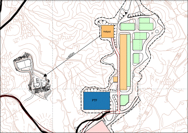
For most sites, no consideration is given to helicopter crashes associated with helipads when there are no helipads within 200m of the site[23]. Since the shortest distance between the GFS helipad in the proposed facility separate and OWTF2 is about 400m, as shown in Figure 11‑10, a background crash rate for helicopters is considered for the OWTF2 facilities in this project.
The background crash rate for helicopters is assumed to be 1x10⁻⁵/km2/year[8], and hence, by accounting for the areas of the vulnerable equipment, their estimated frequencies for helicopter crash can be summarized in Table 11‑14.
Table 11‑14: Helicopter crash frequencies for different equipments in OWTF2
|
Type of equipment |
Area (m2) |
Estimated frequency for helicopter crash (/year) |
|
Anaerobic digesters |
254.5m2 x 3 |
7.64E-09 |
|
Gas holders |
63.6m2 x 2 |
1.27E-09 |
|
Aboveground pipeline |
80 m2 |
8.00E-10 |
|
Sulphur absorption vessels |
7m2 x 2 |
1.40E-10 |
|
Purification unit |
150 m2 |
1.50E-09 |
Figure 11‑10: Distance between proposed helipad and OWTF2 storage
11.5.3.3 Vehicle impact
Only authorized vehicles will be permitted to enter the OWTF2 site, and speed will be restricted for vehicle movements around the site. Safety markings and marked crash barrier will be provided to the above ground pipings, digesters and the gas holder near the entrance[3]. The accident rate is calculated to be 1.7x10⁻⁷ severe car accident per km per year (=0.02+0.15) based on statistical data from HKSARG Transport Department. The detail statistical data is listed in Table 11‑15.
Table 11‑15: Serious and Fatal Vehicle involvements for Medium /Heavy Goods Vehicles
|
|
2004 |
2005 |
2006 |
2007 |
2008 |
2009 |
2010 |
2011 |
2012 |
2013 |
2014 |
Ave |
|
Invol rate: per million veh-km |
0.89 |
0.89 |
0.86 |
0.82 |
0.8 |
0.76 |
0.83 |
0.91 |
0.88 |
0.85 |
0.89 |
0.9 |
|
Total involvements |
1197 |
1180 |
1155 |
1081 |
1045 |
907 |
1031 |
1141 |
1105 |
1085 |
1125 |
1095.6 |
|
Fatal involvements |
31 |
27 |
25 |
21 |
17 |
27 |
16 |
22 |
18 |
26 |
26 |
23.3 |
|
Serious injury involvements |
291 |
257 |
212 |
188 |
176 |
147 |
163 |
196 |
178 |
176 |
181 |
196.8 |
|
Slight injury involvements |
1380 |
1412 |
1364 |
872 |
1176 |
1050 |
1205 |
1370 |
909 |
883 |
918 |
1139.9 |
|
Fatal vehicle involvement ratio |
2.6% |
2.3% |
2.2% |
1.9% |
1.6% |
3.0% |
1.6% |
1.9% |
1.6% |
2.3% |
2.3% |
2.1% |
|
Serious injury involvement ratio |
24.3% |
21.8% |
18.4% |
17.4% |
16.8% |
16.2% |
15.8% |
17.2% |
15.8% |
15.6% |
16.1% |
17.8% |
|
High Impact accident involvement rate per million vehicle km |
0.02 |
0.02 |
0.02 |
0.02 |
0.01 |
0.02 |
0.01 |
0.02 |
0.01 |
0.02 |
0.02 |
0.02 |
|
Medium Impact accident involvement rate per million vehicle km |
0.22 |
0.19 |
0.16 |
0.14 |
0.13 |
0.12 |
0.13 |
0.16 |
0.14 |
0.13 |
0.14 |
0.15 |
11.5.3.4 Other Base Case Frequencies
Spontaneous failure
Spontaneous frequencies are directly adopted from OWTF2 EIA report in this study and summarized in Table 11‑16.
Table 11‑16: Spontaneous failure frequencies as adopted from OWTF2 EIA report
|
Event |
Rupture |
Leak |
|
Gasholder |
1.25 x10⁻⁸ per year |
1.00 x10⁻⁴ per year |
|
Digester/Sulphur Absorption Vessel |
1.00 x10⁻⁵ per year |
1.00 x10⁻⁴ per year |
|
Aboveground Inlet or Outlet piping |
1.00 x10⁻⁷ per metre per year |
5.00 x10⁻⁷ per metre per year |
|
Purification Unit piping |
3.00 x10⁻⁷ per metre per year |
2.00 x10⁻⁶ per metre per year |
Earthquake
Since Hong Kong is not located within the seismic belt and the probability of earthquake occurrence at Modified Mercalli Intensity Scale (MMIS) VII and higher is low in Hong Kong comparing to other regions. So following OWTF2 EIA report, a background frequency is 1.0x10⁻⁵ per year is assumed[24].The earthquake frequency is assumed as 1x10⁻⁵ /year, which is consistent with OWTF2 EIA report[3] and Chai Wan Bus Depot EIA report[24]. The failure probability (for both leak and rupture) of the equipment in an earthquake is assumed to be 0.01[25].
External Fire
In OWTF2 EIA report, the scenario of external fire causing structural damage of equipment in OWTF2 was considered. The frequency of such event was based on the total area of country parks in Hong Kong and hill fire statistics from Agriculture, Fisheries and Conservation Department (AFCD). The average number of hill fires was calculated to be 30 per year by averaging the statistics from year 2009 to year 2013 (range 16 to 51). Since the latest figure of number of hill fires in Hong Kong (Year 2014/15) according to AFCD is 14. The average number of hill fires will be lowered if the latest figure is taken into consideration. In order to maintain consistency, the frequency calculation for external fire in OWTF2 EIA will be adopted.
11.5.3.5 Fault Tree Analysis
The base case frequencies are used in Fault Tree Analysis (FTA) to further derive the frequencies for release scenario. The fault trees are shown in Appendix 11.4a and the assumption used in FTA are listed in Table 11‑17.
Table 11‑17: Assumptions used in FTA
|
Items |
Assumed Value |
Unit |
Remarks |
|
Probability of rupture failure in helicopter crash |
1 |
|
Adopted from OWTF2 Report[3], on a conservative approach |
|
Length of access road |
0.16 |
km |
Adopted from OWTF2 Report[3] |
|
No. of vehicle movement per day |
80 |
|
Adopted from OWTF2 Report[3] |
|
Probability running into gasholder/ digesters/ absorption vessels/ pipelines/ purification unit |
0.5 |
|
Adopted from OWTF2 Report[3], which followed the HATS 2A EIA Report[26] |
|
Probability damage to gasholder/ digesters/ absorption vessels/ pipelines/ purification unit |
1 |
|
Adopted from OWTF2 Report[3], conservative approach |
|
Probability rupture failure in car crash for pipeline / purification unit |
0.1 |
|
Adopted from OWTF2 Report[3], which followed the HATS 2A EIA Report[26] |
|
Probability leak failure in car crash for pipeline / purification unit |
0.9 |
|
Adopted from OWTF2 Report[3], which followed the HATS 2A EIA Report[26] |
The result of FTA (based on updated traffic accident frequencies and the base frequencies as listed above) is summarized in Table 11‑18.
Table 11‑18: Result of Fault Tree Analysis
|
Item Name |
Value |
Unit |
|
Cold catastrophic failure for gasholder per year |
1.24E-05 |
/year |
|
Leak failure of gasholder per year |
4.11E-04 |
/year |
|
Cold catastrophic failure for digester per year |
4.24E-05 |
/year |
|
Leak failure of digester per year |
5.11E-04 |
/year |
|
Cold catastrophic failure of sulphur absorption vessels per year |
3.24E-05 |
/year |
|
leak failure of sulphur absorption vessels per year |
4.11E-04 |
/year |
|
cold catastrophic failure for the piping per year |
5.22E-05 |
/year |
|
Leak failure of the piping per year |
2.91E-04 |
/year |
|
cold catastrophic failure for purification unit per year |
6.22E-05 |
/year |
|
leak failure of purification unit per year |
3.91E-04 |
/year |
Based on the above hazard events frequencies, OWTF2 EIA used the Event Tree Analysis (ETA) method to derive the possible event outcomes. The ETA used in OWTF2 EIA is incorporated in Appendix 11.5a.
11.5.3.6
Ignition Probability
The probability of ignition and explosion following a release depend on several factors, i.e. presence of an ignition source, material that was released, and the rate and the duration of the release. Possible ignition source include hot surfaces, static electricity, flame and hot particle from external fire, etc. [9]. The ignition probabilities are further split between immediate ignition and delayed ignition in equal proportions[22]. Immediate ignition of biogas could lead to a fireball or jet fire, whereas delayed ignition could cause a flash fire or vapour cloud explosion. Table 11‑19, which is adopted from Table 4.22 or OWTF2 EIA report, shows the total ignition probabilities and explosion probabilities adopted from Cox, Lees and Ang[9] according to gas release size.
Table 11‑19: Ignition and Explosion Probabilities for Biogas Releases
|
Release Size |
Probability of Ignition |
Probability of Explosion |
|
Minor (< 1 kg/s) |
0.01 |
0.04 |
|
Major (1 – 50 kg/s) |
0.07 |
0.12 |
|
Massive ( > 50 kg/s) |
0.3 |
0.3 |
In addition to above, ignition sources representing construction workers during the construction phase and the proposed police facilities in operation phase will be adopted. A transportation polyline model as provided in DNV Phast Risk, which calculates ignition probability based on the traffic density and average speed of vehicle, will be used to represent the construction workers in Kong Nga Po Road. An area source with default value of 0.9 ignition probability will be added in the project site.
11.5.4
Frequency Assessment of Proposed Police Facility
11.5.4.1 Case to be assessed
Although the vehicle refilling station in the proposed police facility will store both petrol and diesel, as explained in Section 11.6.3.3, petrol will be used to model diesel which is a more conservative approach.
The worst-case scenario will be the rupture of kerosene/petrol vessel during transport of kerosene/petrol, explanation is given in Section 11.6.3.3.. The occurrence frequency for such event was determined using Fault Tree Analysis and the updated general traffic accident rate in Hong Kong. The Fault Tree is shown in Appendix 11.4b
The FTA showed that the occurrence frequency of a catastrophic release during transport of kerosene along Kong Nga Po Road is about 1.71e-5 per year, while 50% chance it will contain full inventory (3600L) and 50% chance it will only have reserve inventory (500L, on return trip). For petrol transportation, the FTA showed that the frequency of catastrophic failure of road tanker is about 3.43e-5 per year. It is assumed that there is 50% of chance the road tanker will have full inventory (5000L) and 50% chance for having half inventory (2500L) for return trip.
11.5.4.2
Ignition Probability of Kerosene
The probability of ignition is estimated based on the OGP Risk Assessment Data Directory[27] using the release type for tanks and low pressure transfer lines for combustible liquids stored at ambient pressure and at temperatures below the flash point. The ignition probability is assumed to be 0.0024 for 50-1000 kg/s release rate. Since it is assumed in the fault tree analysis that there must be a severe car accident in order to cause a kerosene road tanker vessel rupture, a factor of 10 is added in the ignition probability to account for the fact that it is more likely to have a fire present in a rupture case. The event tree is shown in Appendix 11.5b.
11.5.4.3 Ignition Probability of
petrol
Since petrol is more volatile than kerosene, a different set of ignition probability from Section 11.5.4.2 should be used. In this study, the ignition probabilities from Cox, Lees and Ang model[28] will be used and it is summarized in the following table:
Table 11‑20: Ignition Probability of petrol
|
Size of leakage |
Ignition Probability |
|
Minor (<1kg/s) |
0.01 |
|
Major (1-50kg/s) |
0.03 |
|
Massive (> 50kg/s) |
0.08 |
The values given above are the total ignition probabilities including both immediate and delayed ignition. In current study immediate and delayed ignition is assumed to be the same value[5]. The event tree is shown in Appendix 11.5c.
11.6
Consequence Assessment
11.6.1
Consequence Assessment of SSWTW
11.6.1.1
Overview
For each hazardous event, consequences of these events need to be assessed.
A comprehensive wind tunnel testing was conducted in the Reassessment Study to assess chlorine gas dispersion from the SSWTW. For the NDAs development, medium-rise and high-rise residential/ commercial buildings are planned at distances of more than 1.5 km and 1 km away from the SSWTW for KTN and FLN areas, respectively. The wind pattern near the SSWTW will not be affected at such distances. Therefore, wind tunnel testing results in the Reassessment Study are suitable to be adopted in this HA.
The advantage of a wind tunnel testing over other consequence modelling is that it can simulate the dense gas dispersion under the effects of buildings and complex terrain under different wind speeds and directions.
Therefore, adopting the results from the wind tunnel testing conducted in the Reassessment Study can provide a best estimate of consequences of chlorine gas release.
The following subsections summarize the assumptions and the other calculations from the Reassessment Study to be used in the current consequence assessment.
11.6.1.2
Source Term Modelling
Source Term Modelling in chlorine consequence analysis covers the release rates calculation from the release source to the atmosphere. Depending on the release location there are three major types of releases:
¡ Internal Releases within the store (Event Reference with “IU” prefix)
¡ External Releases on the road (Event Reference with “RU” prefix)
¡ External Releases at the store (Event Reference with “EU” prefix)
Assumptions in the Reassessment Study regarding the initial release of chlorine was adopted in this assessment. The following release rates were adopted in the Reassessment Study (Table 5.1b of Reassessment Study):
Table 11‑21: Release scenarios to be included in this HA
|
Event Reference |
Component Scenarios |
Release rate (or quantity) to atmosphere |
Type of Release |
Release Location |
|
IU1TSRU |
Spontaneous failure Dropped drum |
57 kg |
Instantaneous |
Chlorine store |
|
RU1TSML |
Rollover Loadshedding Spontaneous failure |
1.4 kg/s |
Continuous |
Access road |
|
RU1TMML |
Rollover Truck fire |
4.2 kg/s |
Continuous |
Access road |
|
RU1TSRU |
Truck impact Truck fire Spontaneous failure |
1 tonne |
Instantaneous |
Access road |
|
RU1TMRU |
Truck fire |
3 tonnes |
Instantaneous |
Access road |
|
EU1TMRU |
Earthquake: roof collapse, ground acceleration 0.5g |
10 tonnes |
Instantaneous |
Chlorine store |
|
EU1TMRU1G |
Earthquake: roof collapse, ground acceleration 0.8g |
10 tonnes |
Instantaneous |
Chlorine store |
11.6.1.3 Dispersion of Chlorine in the
Atmosphere
Advanced techniques have been used for prediction of the dispersion of chlorine in the atmosphere in the Reassessment Study and will be adopted in this Study. These techniques take into account the effects of buildings and variable ground terrain on the dispersion of chlorine in the atmosphere. The modelling of the dispersion of chlorine in the atmosphere involves three elements:
¡ Wind tunnel simulations;
¡ Computational Fluid Dynamics (CFD); and
¡ Flat terrain dispersion modelling
The wind tunnel and CFD studies represent the ‘state of the art’ in dense gas dispersion modelling and provide the only rigorous means of accounting for the effect of buildings and complex terrain. Wind tunnel testing has been used in the Reassessment Study to investigate a range of release scenarios, wind directions and wind speeds in near-neural atmospheric conditions. CFD has been used to determine the influence of atmospheric stability on the dispersion of chlorine and provide a broad comparison against the wind tunnel results for neutral stability. Wind tunnel simulations were undertaken for all eight sites that have been assessed in Reassessment Study, whereas CFD modelling was undertaken for two sites representing the extremes of topography (Sha Tin WTW and Tai Po Tau WTW). Both the wind tunnel testing and CFD modelling have included off-site high rise buildings as well as on-site buildings, as these have a significant influence on the dispersion of chlorine.
The role of the flat terrain dispersion modelling has been to provide the ‘source term’ for both the wind tunnel and CFD studies. DRIFT contains the necessary thermodynamics and heat transfer sub-models to be able to simulate the dispersion of a cold, aerosol-laden cloud typical of the early stage of a chlorine release. In conjunction with the wind tunnel and CFD, this provides all the data needed for input to the QRA.
11.6.1.4
Toxic Impact Assessment
Chlorine Probit equation, shown below, is used for estimating the fatality rate of human expose to chlorine gas in the Reassessment Study. The equation is implicitly adopted as the LD contours have been adopted in this assessment.
![]()
where
Pr = Probit value
C = Chlorine Concentration (mg/m3)
t = exposure time (minutes)
For a 10 minutes exposure, the chlorine toxicity is summarized as follows:
Table 11‑22: Chlorine toxicity relationship
|
Probability of fatality |
Probit value for 10 min exposure |
Equivalent chlorine concentration (ppm) |
|
0.03 (LD03) |
3.17 |
251 |
|
0.5 (LD50) |
5.00 |
557 |
|
0.9 (LD90) |
6.28 |
971 |
11.6.1.5
Chlorine Cloud Height
Height of Chlorine Cloud for various release cases will be considered, using the same approach as the Reassessment Study, to determine the effect to people inside high-rise buildings. Equivalent number of storeys of a building may be affected by the gas cloud is estimated. The details of the cloud height estimation is tabulated in Table 4.2g of the Reassessment Study report and replicated in Table 11‑23.
Table 11‑23: Cloud Height Adopted for Release Events
|
Release Event |
Cloud Height (m) |
Equivalent Numbers of Storeys (3m per Storeys) |
Reassessment Study Report Ref. |
|
1.4 kg/s continuous |
30 |
10 |
Table 4.2g |
|
1 tonne instantaneous |
6 |
2 |
Table 4.2g |
|
10 tonne instantaneous |
9 |
3 |
Table 4.2g |
11.6.1.6
Scaling Factors for LD Contour
Cloud dispersion contours from wind tunnel results in the Reassessment Study will be adopted. Based on the wind tunnel data, factors will be applied to scale up/down wind tunnel data for various release quantities, wind speeds. Horizontal scaling factor is obtained from the DRIFT flat terrain dispersion modelling results for release mass and a simple scaling factor 0.7 is applied for wind speed 5ms-1, as adopted in the Reassessment Study.
11.6.1.7
Assumption of Escape from Gas Cloud
The possibility of escape from a gas cloud for an exposed person is normally taken into account in determination of probability of fatalities of outdoors population. The effective outdoor probability of fatality applied in the Reassessment Study (Table 4.1b of the study report refers) will be applied in this HA. Escape from a gas cloud is deemed impossible for inmates and staff in Lo Wu Correctional Institution, thus not considered for them.
11.6.1.8
Sensitive Population Consideration
Population at locations accommodating sensitive population i.e. young, elderly and the infirm (e.g. population in primary schools, hospital, etc.) would have the fatality probability higher than that of the average population. To cater this effect, a vulnerable population factor of 3.3 was applied to the population of these locations as adopted in the Reassessment Study.
11.6.1.9
Impact to Road Population
The methodology documented in Annex F2 of the Reassessment Study report to model the effect of chlorine release on transient populations, in particular road vehicles, will be adopted. This methodology considers the extents of chlorine build up inside the vehicle and whether this could impair the driver’s ability to cause a vehicle to come to a standstill.
11.6.1.10
Summary
The assumptions, input parameters of the Reassessment Study and the wind tunnel testing results presented in LD contour plot will be adopted in this study.
11.6.2
Consequence Assessment of OWTF2
11.6.2.1 Thermal Radiation
Any fire event, no matter it is a pool fire, jet fire or fireball, will cause thermal radiation hazards in addition to the damage cause by direct engulfing the structure/person in the flame. The probability of fatality, due to heat radiation is given by the following Probit relationship by Eisenberg et al.[15]:
![]()
Where:
Pr is the Probit number which can be transformed to probability of death by Probit chart
Q is the heat radiation intensity (kW/m2);
t is the exposure time (s)
A maximum exposure time of 20s is adopted in this HA which is the default value in DNV Phast Risk.
High thermal radiation will also damage structures and buildings. The criteria of 37.5kW/m2 is adopted for structural damage according to Lee’s Loss Prevention[9].
11.6.2.2 Explosion Damage
Following the OWTF2 methodology, the explosion hazard of biogas will be quantified by DNV’s Phast Risk v6.7 Multi-energy model. The assessment criteria will be 0.2 bar for damage to heavy machinery, and the fatality probability as shown in Table 11‑24 from CIA guidelines[29]:
Table 11‑24: End Point Criteria for explosion risk
|
Overpressure (psi) |
Fatality Probability (outdoors) |
Fatality Probability (indoors) |
|
5 |
0.09 |
0.55 |
|
3 |
0.02 |
0.15 |
|
1 |
0.00 |
0.01 |
11.6.2.3 Consequence Distance
As there is no change in the process and inventory of biogas in the OWTF2, the consequence assessment of OWTF2 EIA is deemed valid to be adopted in this study. Some of the important findings are summarized in the following Table 11‑25:
Table 11‑25: Consequence distances adopted from OWTF2 EIA report
|
Event ID |
Release Scenario |
Release Size |
Outcome |
The Worst Hazard Distance (Weather Class) |
|
|
01
|
Gasholder
|
Rupture
|
800 m3 |
Fireball |
28.9 m |
|
VCE |
80.6 m |
||||
|
Flash fire |
52.2 m (7D) |
||||
|
Leak
|
300 mm dia. |
Jet fire |
35 m (7D) |
||
|
VCE |
43.7 m |
||||
|
Flash fire |
19.7 m (1F) |
||||
|
02
|
Digester |
Rupture
|
286 m3 |
Fireball |
20.4 m |
|
VCE |
61.2 m |
||||
|
Flash fire |
34.1 m (7D) |
||||
|
Leak
|
300 mm dia. |
Jet fire |
36.1 m (7D) |
||
|
VCE |
43.3 m |
||||
|
Flash fire |
19.2 m (1F) |
||||
|
03
|
Aboveground inlet or outlet piping / pump / non-return valve / flange |
Full bore rupture
|
300 mm dia. |
Jet fire |
30.9 m (7D) |
|
VCE |
33.7 m |
||||
|
Flash fire |
15.5 m (1F) |
||||
|
Leak
|
30 mm dia. |
Jet fire |
5.0 m (7D) |
||
|
VCE |
N/A |
||||
|
Flash fire |
1.9 m (1F) |
||||
|
04
|
Sulphur Absorption Vessel
|
Rupture
|
5 m3 |
Fireball |
6.1 m |
|
VCE |
17.8 m |
||||
|
Flash fire |
20.1 m (1F) |
||||
|
Leak
|
10 mm dia. |
Jet fire |
2.21 m (7D) |
||
|
VCE |
N/A |
||||
|
Flash fire |
0.65 m (1F) |
||||
|
06
|
Purification Unit |
Full bore rupture
|
100 mm dia. |
Jet fire |
94.7 m (7D) |
|
VCE |
47.7 m |
||||
|
Flash fire |
146.8 m (7D) |
||||
|
Leak
|
10 mm dia. |
Jet fire |
6.7 m (7D) |
||
|
VCE |
N/A |
||||
|
Flash fire |
4.6 m (1F) |
||||
11.6.3
Consequence Assessment of Proposed Police Facilities
11.6.3.1
DG storage within the site
All of the chemicals are stored in separate metal/plastic containers and it is not expected to have a single event that can release all the inventory of all containers instantaneously.
The following consequences may occur if the chemicals in the DG store leak and then ignited:
¡ Pool fire – it is expected that the pool fire will be contained in the DG store and presents negligible off-site hazard. According to FSD regulation, the DG store should be constructed with at least 2 hours fire resistant rating (FRP) material.
¡ Fireball and explosion – Unless there is a fire inside the store, it is not possible have instantaneous release of large amount of the chemicals inside the store simultaneously. As a result, it is not expected to have large scale chemical vapour release through the DG store ventilation system to the atmosphere, causing Vapour Cloud Explosion outside of the DG store.
Despite the above, an extreme scenario of un-bunded pool fire is carried out to demonstrate that even in this scenario it is not possible to generate off-site hazard. By using DNV Phast, a pool fire caused by an instantaneous release of 150L of toluene (to model turpentine) was modelled under different wind speeds and the maximum consequence distance (pool radius plus the radiation damage range, for 1% fatality rate with 20s exposure) is less than 25m.
Table 11‑26: Maximum pool radius for an un-bunded pool fire in DG store
|
Wind Speed (m/s) and Weather Class |
Maximum pool radius (m) |
|
2.5 (B) |
23.1 |
|
1.5 (D) |
22.7 |
|
3.5 (D) |
23.3 |
|
7 (D) |
23.2 |
|
2.5 (E) |
23 |
|
1.5 (F) |
23 |
11.6.3.2 Kerosene Transport
Source term modelling
The worst case hazardous scenario is considered during transport of kerosene along Kong Nga Po Road – i.e. the catastrophic rupture of road tanker causing the release of entire content and lead to a pool fire.
In other cases such as small leaks, there will be enough time for the driver to react such as park the vehicle in road side, turn off engine and signal other drivers to stay away from the truck. It is expected that there will not be any fatality associated with those scenarios. Nonetheless, the leaks scenario is implicitly incorporated into the rupture case in the Fault Tree Analysis by assuming all serious traffic accident happening to the kerosene truck will cause a rupture case, which is a conservative assumption.
Effect Modelling
When an accident occurs during kerosene transport, loss of containment of kerosene may result. The following consequence may occur:
¡ Jet Fire
¡ Pool Fire
¡ Fireball
¡ Boiling Liquid Expanding Vapour Explosion (BLEVE)
Jet Fire
A jet fire may occur if there is a leak in a pressurized vessel. Since kerosene is transported in atmospheric pressure, it is very unlikely to cause a jet fire during a leak scenario. The kerosene vessel may be pressurized if there is a pool fire under the vessel which heats up and vaporise the kerosene inside the vessel, but in that case the pool fire scenario has sufficiently covered the affected area and thus jet fire will not be further studied in this Assessment.
Pool Fire
Since the boiling point of kerosene is much higher than atmospheric temperature, during a loss of containment scenario (leak or rupture of kerosene vessel), the kerosene will rainout and cause a pool around the truck. It will be ignited when it is in contact with fire (a weak ignition source cannot ignite the kerosene pool as discussed earlier), which is quite possible during a severe car collision. It is considered that the pool fire scenario will be most severe scenario during transportation of kerosene within Kong Nga Po Road and will be considered in this study.
Fireball
A fireball may occur if a pressurized vessel ruptures, or when an atmospheric vessel storing volatile liquid is exposed to heat. As discussed, the kerosene will be transported in atmospheric pressure below its flash point, which makes a fireball event very unlikely to occur. Previous reports such as Permanent Aviation Fuel Facility EIA report[16], South Island Line EIA[17], Expansion of Hong Kong Airport into a Three-Runway System[5] also did not consider fireball as a hazardous scenario. Hence fireball scenario will not be further discussed in this Assessment.
BLEVE
A BLEVE explosion may occur if a vessel is subjected to a jet fire impingement, heating up the content building up enormous pressure inside the vessel, when the vessel rupture from the hot spot created by the jet fire or other weak points of the vessel, all the pressurized liquid will expand and vaporize at the same time and cause a severe explosion. During kerosene transport, it is very unlikely that the kerosene vessel will run into a jet fire. And if the fire is caused by the leak from the kerosene vessel itself, the leak hole may already be too large for pressure to build up within the vessel, as a considerable size of pool is required to heat up the kerosene fast enough considering the high boiling point of kerosene. With these considerations the BLEVE case is not considered in this Assessment.
Table 11‑27: Consequence distances for the hazardous scenarios of kerosene road tanker
|
Wind Speed (m/s) and Weather Class |
Catastrophic rupture of kerosene road tanker (pool fire diameter (m)) |
|
2.5 (B) |
54 |
|
1.5 (D) |
50 |
|
3.5 (D) |
60 |
|
7 (D) |
61 |
|
2.5 (E) |
54 |
|
1.5 (F) |
50 |
11.6.3.3
Petrol/Diesel Filling Facility
Modelling approach
Table 11‑8 has listed some physical properties of petrol and diesel. Since petrol is generally more volatile and more easily get ignited when it is leaked, in this assessment gasoline would be used to model diesel, which is a more simplified and yet conservative approach.
Gasoline is a mixture of hydrocarbon from range approximately from C4 to C12. In order to model gasoline, octane (C8) which is in the middle range of gasoline series, will be used to model gasoline.
Source term modelling
Among the hazardous scenarios discussed in the risk identification section (Section 11.4.3), the worst-case consequence would be:
¡ Catastrophic rupture of road tanker
¡ Traffic accident destroying the dispenser/fixed pipework/flexible hose leading to leakage of petrol/diesel from the underground storage tank, if the protection system such as pull-away coupling, emergency shutdown systems etc. are either not available or not functioning as expected.
In both cases, worst case scenario would be a late pool fire of the maximum inventory of the road tanker / underground storage tank.
Effect modelling
Compared with kerosene, petrol is more volatile and able to form a gas cloud. Hence for effect modelling of petrol, flash fire will also be considered in addition to pool fire.
Consequence modelling has been carried out using DNV Phast. The maximum consequence distance (defined by 1% fatality) for each of the scenario has been summarized in the following table:
Table 11‑28: Consequence distances for the hazardous scenarios of petrol/diesel filling station
|
Wind Speed (m/s) and Weather Class |
Max. consequence distance (m) |
||
|
Catastrophic rupture of petrol road tanker (Pool fire diameter, 1% fatality) |
Line rupture of pipework/hose for petrol filling station* (Pool fire diameter, 1% fatality) |
Line rupture of pipework/hose for petrol filling station* (flash fire 50% LFL radius) |
|
|
2.5 (B) |
50 |
52 |
3.44 |
|
1.5 (D) |
48 |
50 |
3.42 |
|
3.5 (D) |
54 |
56 |
3.45 |
|
7 (D) |
60 |
64 |
3.6 |
|
2.5 (E) |
50 |
52 |
3.43 |
|
1.5 (F) |
48 |
50 |
3.49 |
*Since no information is available regarding the current design of the petrol/diesel filling station, it is assumed that the pipe diameter is 50mm with constant pressure of 0.1barg provided by the submersible pump in the underground storage tank.
The above analysis shows that the maximum consequence distance for hazardous scenarios in petrol/diesel filling station is within 32.5m (radius). Since the nearest population from the petrol/diesel filling station is about 370m, no offsite impact regarding petrol/diesel refilling operation is envisaged. Risk impact of petrol/diesel road tanker transportation within Kong Nga Po Road will be calculated and presented in Section 11.7.
11.6.3.4 Smoke impact
Diesel is composed of relatively long-chain hydrocarbon. Diesel fire can produce toxic smoke which may harm nearby population due to its high temperature, high carbon monoxide and soot content. However, since the proposed police facility is situated in a local high point (> +60mPD), and hot smoke will rise and only affect high-rise building (which is not present in the vicinity), smoke impact to adjacent population is not envisaged.
11.6.3.5 Escalation of impact (Knock-on
effect)
The relative positions of the facilities involving non-fuel dangerous goods are shown in the Figure 11‑11:
Figure 11‑11: Relative Position of non-fuel gas facilities within the site
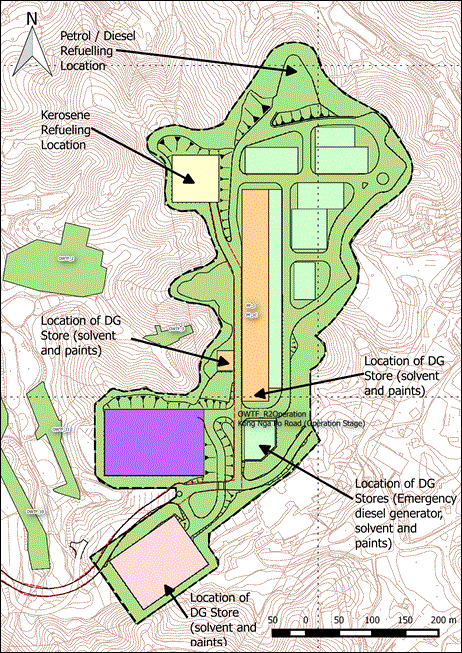
As discussed in the previous sections, many of the possible hazards that may happen in the site actually are confined within the Dangerous Goods stores which has adequate firing proofing ability and sufficient fire-fighting system to prevent escalation of fire outside of the store before FSD takes control.
As for the petrol and diesel refuelling facility, Table 11‑28 has demonstrated the consequence distance for 1% fatality. For damage of building structure, a much higher radiation level (37.5 kW/m2) is required and thus the consequence distance will be even shorter.
All the DGs are kept in DG stores constructed with fire resisting material and fire mesh etc. to prevent fire ingress to the DG store, and the separation distance between the nearest DG store and the gasoline/diesel refuelling facility is at least 400m, the chance of knock-on/escalation effect to the DG stores can be regarded as zero.
11.7
Risk Assessment
11.7.1
Risk Summation
By combining the results of frequency estimation and consequence analysis, risk levels of the assessment scenarios will be characterised in terms of individual risk (presented in individual risk contours plot) and societal risk (presented in FN curves).
For chlorine risk by SSWTW, this integration of risk was processed using RISKSUM. For the biogas risk of OWTF2, kerosene risk by police facility and other hazards, the risk integration was conducted by DNV Phast Risk version 6.7
The level of risk in terms of Individual Risks and the FN curves determined from the risk summation process will be compared with the criteria stipulated in Annex 4 of the TM[7] to determine their acceptability.
The off-site risk level was checked whether it is less than 1 x 10⁻⁵ / year (i.e. 1 in 100,000 per year).
The determination of acceptability of societal risk in the form of FN curves will be based on the following criteria:
Unacceptable where risks are so high that they should usually be reduced regardless of the cost or else the hazardous activity should not proceed;
ALARP (As Low As Reasonably Practicable) where the risks associated with the hazardous activity should be reduced to a level “as low as reasonably practicable”, in which the priority of measures is established on the basis of practicability and cost to implement versus risk reduction achieved; and
Acceptable where risks are so low that no action is necessary.
11.7.2 Individual Risk
11.7.2.1 Individual Risk Result of
SSWTW
As mentioned throughout the report, the frequencies and consequences of the hazardous scenarios in SSWTW are almost identical to the NENT NDA EIA report except the new/old drum issue and updated weather data. As a result, the generated individual risk contour is also very similar.
The updated individual risk contour of SSWTW is illustrated in Appendix 11.7.1. The maximum individual risk level is in the range of 1x10⁻⁶ per year and 1x10⁻⁷ per year, which is lower than 1x10⁻⁵ per year thus meets the individual risk criteria.
11.7.2.2 Individual Risk Result of
OWTF2
The individual risk result of OWTF2 is presented in Appendix 11.7.2. The maximum individual risk remains below 1x10⁻⁵ per year at the site boundary and hence meets the individual risk requirement. From the individual risk analysis, it clearly showed that the effect of OWTF2 hazardous scenarios can hardly affect the population in the proposed police facility in Kong Nga Po.
11.7.2.3 Individual Risk Result of
proposed police facility
The individual risk contour of kerosene and petrol transport along Kong Nga Po Road is shown in Appendix 11.7.3. The highest individual risk in the whole section of road is within 1x10⁻⁸ per year. The risk is well within the individual risk criteria in Hong Kong Risk Guidelines.
11.7.3 Societal Risk
The FN result is shown in Appendix 11.8
11.7.3.1 Societal Risk of SSWTW
The FN curve of SSWTW showed that the construction of and operation of the police facility does not affect the overall societal risk due to the hazardous scenarios of SSWTW, and the risk is still within the acceptable region as specified in Annex 4 of EIAO-TM.
11.7.3.2 Societal Risk of OWTF2
From the individual risk contour it is apparent that most of impact of the hazardous scenarios from OWTF2 confine within the site boundary. As a result, the increase in population in Proposed Police Facilities and the increase in traffic in Kong Nga Po Road does not increase the societal risk of OWTF2. Since the FN curve lies within the acceptable region, no risk mitigation measure is required and the risk level is compliant with the criteria as set out in Annex 4 of EIAO-TM.
11.7.3.3
Societal Risk of proposed police facility
The societal risk curve of the proposed police facility showed that the transport of petrol/diesel/kerosene along Kong Nga Po Road may induce 6 or below fatality, due to the release of fuel during a traffic accident or a spontaneous failure. However, the frequency of occurrence of such events are low and combined within the road area which has very low traffic density, the combined F-N satisfied the EIAO-TM requirement.
11.7.4 Cumulative Risk Assessment
A cumulative risk assessment, especially for the operation case in year 2029, is performed and shown in Appendix 11.9.1 and Appendix 11.9.2. It is done by addition of the two individual risk matrices at every grid point in the consultation zone. The individual risk contours summation operation essentially covered the 1x10⁻¹⁰/year contour of each facility. The cumulative individual risk contour showed that the cumulative effect of the three major sources of risk, i.e. SSWTW, OWTF2 and the proposed police facility, is not significant.
The overall FN curves were calculated by manual addition of all available FN pairs. It should be noted that for cumulative risk assessment, the staff working in the hazardous facilities will not be counted in fatality calculation for the hazards generated in the same facility. For example, the societal risk calculation of OWTF2 will not include the staff in OWTF2; whereas when calculating the societal risk from the hazardous scenario from the police facility, the staff and trainees in the police facility will not be taken into account.
The cumulative FN curves are shown in Appendix 11.9.3. The cumulative societal risk curve showed that there is an increase of frequency in the low fatality region mainly due to the contribution of the risk of the proposed police facility. However, the whole curve is still within the “Acceptable” region as stipulated in EIAO-TM. Since the cumulative FN curve covered population groups potentially impacted by three individual facilities located distinctly, it is conservative to include the societal risks for three facilities in one FN chart.
11.7.5 Uncertainty analysis
The uncertainty analysis assessed the level of uncertainty in the estimates of individual risk and societal risk by carrying out sensitivity studies on the key parameters and modelling assumptions, and gauge the level of confidence in the risk results.
11.7.5.1 SSWTW
The uncertainty analysis has been extensively studied in the Annex K of Reassessment Study. They will be reviewed in this study. The results of the uncertainty analysis in Annex K of Reassessment Report are summarized in Table 11‑29.
Table 11‑29: Summary of uncertainty analysis
|
Parameter |
Magnitude |
Affect frequency (F) or number of fatalities (N)? |
|
Influence of atmospheric stability on direction of travel of chlorine cloud in complex terrain |
Over/under-prediction by a factor of 2 |
F or N |
|
Extend of isopleths predicted by wind tunnel |
Over/under-prediction by a factor of 2 |
N |
|
Chlorine toxicity relationship |
Over-prediction by a factor of 5 - 15 |
N |
|
Base event frequency data |
Over/under-prediction by a factor of 10 |
F |
|
Conditional probabilities |
Over/under-prediction by a factor of 3 |
F |
11.7.5.2 OWTF2
Uncertainty analysis was not discussed in the OWTF2 EIA report. Nonetheless, a few observations regarding uncertainty can be summarized below:
1. Influence of atmospheric condition: In the OWTF2 model, it is assumed that the plant itself is a strong ignition source and source of congestion which may lead to explosion of flammable gas cloud. The individual risk contour also suggested that most of the hazardous outcomes (explosion, flashfire, etc.) happened inside the site boundary due to the fact that it is very likely to get ignited/detonated right after release. Hence influence of atmospheric condition (wind speed and wind direction) is not a significant factor leading to uncertainty.
2. Inventory of flammable gas inside OWTF2: Based on the OWTF2 EIA report, it is assumed full inventory in all digesters, gas holders and purification units, which is a conservative estimate and will overestimate the number of fatality. While the actual average inventory level in the future OWTF2 is unknown and will be dependent on the supply of organic waste source, it is estimated that the actual average volume of flammable gas inside the plant can be as low as 50% of current estimate using full inventory.
3. Base event frequencies data: Since the data source for base event frequencies for OWTF2 EIA is similar to other EIA studies in Hong Kong (e.g. Annual Traffic Census and accident statistics from Transportation Department of Hong Kong, etc.), a factor of ± 10 can be assumed on the effect on overall frequency (F) following other EIA studies in Hong Kong.
Table 11‑30: Summary of uncertainty analysis for OWTF2
|
Parameter |
Magnitude |
Affect frequency (F) or number of fatalities (N)? |
|
Inventory of flammable gas inside OWTF2 |
Over-prediction by a factor of 2 |
N |
|
Base event frequencies data |
Over/under-prediction by a factor of 10 |
F |
11.7.5.3 Proposed Police Facility
The uncertainty associated with the assessment of risk of the proposed facility is mainly on the conservative side:
1. Inventory: Since the kerosene road tanker belongs to GFS and is called upon for the specific refuelling task. The road tanker will only carry just enough amount of kerosene plus small amount of reserve to the spot in most of the circumstances, so the uncertainty on the inventory amount is very low.
2. Prevailing wind direction: Since only 1 scenario – the catastrophic rupture of road tanker leading to a pool fire is considered. The effect of wind on such scenario is minimal.
3. Population along Kong Nga Po Road: Since the population estimate of Kong Nga Po Road was based on the assumption that there will be residential development in Kong Nga Po. Even considering the future traffic generated by police facility and OWTF2, the transient population is considered to be overestimated. It will in turn overestimate the overall fatality (N) by a factor of approximately 2.
Table 11‑31: Summary of uncertainty analysis for the proposed police facility
|
Parameter |
Magnitude |
Affect frequency (F) or number of fatalities (N)? |
|
Population along Kong Nga Po Road |
Over/under-prediction by a factor of 2 |
N |
11.7.6
Cost-Benefit
Analysis
Since the level of risk is within the “Acceptable” risk criteria, no risk mitigation measure is required and thus cost-benefit analysis is not necessary in this Study.
11.7.7 Summary
Individual risk and societal risk were determined both individually for each facility as well as cumulatively to produce a full picture of the risk level. It is found out that the risk are within “Acceptable” level as stipulated in EIAO-TM, individually and cumulatively. As a result, no risk mitigation is required.
11.8
Environmental Monitoring & Auditing
Although risk mitigation measures are not required for this project, some measures / good practices are recommended and summarized below:
1. All DG stores should be constructed according to the standards and recommendations by FSD, having adequate fire-fighting facilities, proper ventilation and fire-proofing requirement.
2. All DGs such as paints and solvents should be stored in their respective DG rooms.
3. Adequate fire-fighting equipment, such as fire extinguishers, fire sand etc. should be present during kerosene refuelling operation at the helipad.
4. Proper earthing equipment and procedures should be in place to prevent accumulation of static electricity during kerosene refuelling operation.
5. GFS kerosene road tanker and the helicopter pilot should follow the established protocol for arriving at the helipad to prevent helicopter crashing on the road tanker.
6. Refuelling will only be performed in daytime.
7. Underground storage tanks will be used for petrol/diesel storage.
8. Kerosene pump will be equipped with pressure switch to prevent overfilling.
11.9
Conclusion
A hazard-to-life assessment was carried out for the Proposed Police Facility in Kong Nga Po. The potential impacts from nearby PHI to the Project, as well as the risk impact by the transport, storage and use of helicopter fuel and other DGs were analysed. By carrying out Quantitative Risk Assessment on the facilities, it can be concluded that the overall risk (in terms of individual risk and societal risk level) satisfy the requirement as stipulated in the Annex 4 of the Technical Memorandum of Environmental Impact Assessment Ordinance, and no risk mitigation measure is necessary. Recommendations / good practices are proposed to ensure the safe operation of the proposed police facilities.
11.10
Reference
[1] "Reassessment of Chlorine Hazard for Eight Existing Water Treatment Works: Hazard Assessment for Sheung Shui Water Treatment Works," Civil Engineering and Development Department, Hong Kong2001.
[4] "Judgment on Final Appeal between Shiu Wing Steel Limitied and Director of Environmental Protection," ed. Hong Kong: Final Court of Appeal, 2005.
[7] Environmental Impact Assessment Ordinance, Chapter 499.
[8] "Tsuen Wan Byass, Widening of Tsuen Wan Road between Tsuen Tsing Interchange and Kwai Tsing Interchange, and Associated Junction Improvement Works," Civil Engineering and Development Department, Hong Kong2008.
[9] S. Mannan and F. P. Lees, Lee's loss prevention in the process industries : hazard identification, assessment and control, 3rd ed. / [edited by] Sam Mannan. ed. Amsterdam ; London: Elsevier Butterworth-Heinemann, 2005.
[10] "Diesel Fuels Technical Review," Chevron Products Company, US2007.
[12] Methanol Safe Handling Technical Bulletin - Part 1-B: Physical and Chemical Properties of Selected Fuels. Available: http://www.methanol.org/Health-And-Safety/Technical-Bulletins/Technical-Bulletins/UsingPhysicalandChemicalPropertiestoManageFlam-(1).aspx
[13] "Diesel Fuel Material Safety Data Sheet," National Cooperative Refinery Association1992.
[14] P. Fewtrell, A. Petrie, I. Lines, N. Cowell, A. Livingston, and C. Jones, "Quantified risk assessment of aircraft fuelling operations, HSE Contract Research Report CRR288," W S AtkinsJuly 2000.
[16] "Environmental Assessment Services for Permanent Aviation Fuel Facility Environmental Impact Assessment Report," ESR TechnologyFeb 2007.
[20] "Safety Report 2014," International Air Transport Association, Montreal—GenevaApr 2015.
[22] "Development of a Biodiesel Plant at Tseung Kwan O Industrial Estate - Environmental Impact Assessment Report," Hong Kong2008.
[26] "Harbour Area Treatment Scheme Stage 2A Environmental Impact Assessment," Drainage Services Department, Hong Kong2008.
[27] "International Association of Oil & Gas Producers (OGP) Risk Assessment Data Directory," 2010.
[28] A. W. Cox, F. P. Lee, and M. L. Ang, Classification of Hazardous Locations. Rugby, UK: Institution of Chemical Engineers, 1990.