TABLE OF CONTENTS
2 PROJECT DESCRIPTION AND CONSIDERATION OF ALTERNATIVES
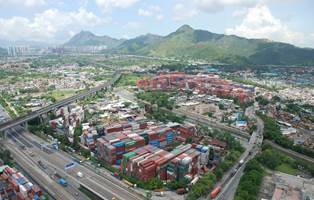
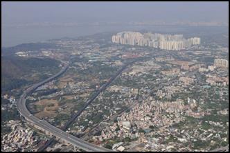
2.3 Appreciation of Existing Environment
2.4 Description of the Project (Revised
RODP)
2.5 Project Benefits and Green Initiatives
2.6 Formulation of the Revised Recommended
Outline Development Plan
2.9 Major Amendments from RODP to Revised
RODP
2.10 Consideration of Alternatives and
Development of the Preferred Option
2.11 Development Programme for Project
APPENDICES
Appendix 2.1.1 Consideration of
Alignment for Road P1 (Option 1)
Appendix 2.1.2 Consideration of
Alignment for Road P1 (Option 2)
Appendix 2.2 Consideration of
Land Use Zonings Associated for San Sang San Tsuen Egretry
Appendix 2.3 Consideration of
Flushing Water and Fresh Water Service Reservoir Locations
Appendix 2.4 Implementation
Programme and Phasing
FIGURES
Figure 2.1 Major Component
of the Proposed Road Hierarchy
Figure 2.2 Revised
Recommended Outline Development Plan (RODP)
Figure 2.2.1 Revised
Recommended Outline Development Plan (RODP) (Northern Area)
Figure 2.2.2 Revised
Recommended Outline Development Plan (RODP) (Southern Area)
Figure 2.3.1 General Layout of
New Distributor Road (Road P1) – Sheet 1 of 5
Figure 2.3.2 General Layout of
New Distributor Road (Road P1) – Sheet 2 of 5
Figure 2.3.3 General Layout of
New Distributor Road (Road P1) – Sheet 3 of 5
Figure 2.3.4 General Layout of
New Distributor Road (Road P1) – Sheet 4 of 5
Figure 2.3.5 General Layout of
New Distributor Road (Road P1) – Sheet 5 of 5
Figure 2.4.1 General Layout of
New Distributor Road (Road D1) – Sheet 1 of 4
Figure 2.4.2 General Layout of
New Distributor Road (Road D1) – Sheet 2 of 4
Figure 2.4.3 General Layout of
New Distributor Road (Road D1) – Sheet 3 of 4
Figure 2.4.4 General Layout of
New Distributor Road (Road D1) – Sheet 4 of 4
Figure 2.5.1 General Layout of
New Distributor Road (Road D2) – Sheet 1 of 3
Figure 2.5.2 General Layout of
New Distributor Road (Road D2) – Sheet 2 of 3
Figure 2.5.3 General Layout of
New Distributor Road (Road D2) – Sheet 3 of 3
Figure 2.6.1 General Layout of
New Distributor Road (Road D3) – Sheet 1 of 2
Figure 2.6.2 General Layout of
New Distributor Road (Road D3) – Sheet 2 of 2
Figure 2.7.1 General Layout of
New Distributor Road (Road D4) – Sheet 1 of 2
Figure 2.7.2 General Layout of
New Distributor Road (Road D4) – Sheet 2 of 2
Figure 2.8.1 General Layout of
New Distributor Road (Road D5) – Sheet 1 of 2
Figure 2.8.2 General Layout of
New Distributor Road (Road D5) – Sheet 2 of 2
Figure 2.9.1 General Layout of
New Distributor Road (Road D6) – Sheet 1 of 3
Figure 2.9.2 General Layout of
New Distributor Road (Road D6) – Sheet 2 of 3
Figure 2.9.3 General Layout of
New Distributor Road (Road D6) – Sheet 3 of 3
Figure 2.10 General Layout of
New Distributor Road (Road D7)
Figure 2.11.1 General Layout of
New Distributor Road (Road D8) – Sheet 1 of 2
Figure 2.11.2 General Layout of
New Distributor Road (Road D8) – Sheet 2 of 2
Figure 2.12.1 Cross-section of
New Distributor Roads Serving The HSK NDA – Sheet 1 of 3
Figure 2.12.2 Cross-section of
New Distributor Roads Serving The HSK NDA – Sheet 2 of 3
Figure 2.12.3 Cross-section of
New Distributor Roads Serving The HSK NDA – Sheet 3 of 3
Figure 2.13 Location Plan of
Designated Project 9 (DP9) – New Sewage Pumping Stations
Figure 2.14 General Layout of
Sewage Pumping Station No. 1
Figure 2.15 General Layout of
Sewage Pumping Station No. 2
Figure 2.16 General Layout of
Sewage Pumping Station No. 3
Figure 2.17 General Layout of
Sewage Pumping Station No. 4
Figure 2.18 Development
Phasing Plan
Figure 2.19 Locations of
Concurrent Projects
2 PROJECT DESCRIPTION AND CONSIDERATION OF ALTERNATIVES
2.1
Site Location and
History
2.1.1
The Hung Shui Kiu New Development Area (HSK NDA)
(herein referred to as the “Project”) occupies an area of approximately 714 ha
and is located in the northwestern part of the New Territories, midway between
the Tuen Mun and Tin Shui Wai (TSW) New Towns (refer to Figure
1.1 for location plan). It is bounded by Tin Ying Road / Ping Ha Road /
Kiu Hung Road to the east, Castle Peak Road to the south, Kong Sham Western
Highway (KSWH) to the west, and Tin Ha Road, Lau Fau Shan Road and hillslopes
along Deep Bay Road to the north. In the wider context, the proposed Project is
strategically located in close proximity to Shenzhen, particularly Shenzhen Bay
Control Point, Qianhai, and Shekou and efficiently linked with the Greater Pearl
River Delta (PRD) region. The KSWH and the possible highway connecting the
Project area with the Tuen Mun - Chek Lap Kok Link, the Hong Kong International
Airport, Kwai Tsing Container Terminals, and the Hong Kong-Zhuhai-Macao Bridge
and its Boundary Crossing facilities. New strategic highway infrastructure
connecting the Project area with the urban area will also be planned to address
the long-term development needs of North West New Territories (NWNT). The
proposed West Rail Hung Shui Kiu Station (HSK Station), with its alignment
traversing the Project allows convenient and efficient access to and from the
Project area.
2.1.2 The Project area and boundary have evolved with time as the master planning process attempted to address comments received from public consultation, resolve planning anomalies and facilitate an increase in the availability of developable land for the Project. In particular, the area to the south of Castle Peak Road has been excluded from the Project boundary given the presence of well-established communities with existing clustered villages and private developments, and limited available land for further major development. In addition, the site to the west of KSWH was included within the Project boundary due to its potential to be utilised for other land uses (i.e. “Industry” (“I”) zone) that could provide job opportunities for the future population within the Project. The inclusion of the TSW Main Channel adjacent to TSW within the Project area also provided an opportunity for a more holistic approach regarding proposed enhancements which would benefit the future residents within the NDA and also TSW. The boundary was also extended to include the extent of the KSWH, to accommodate the proposed Road P1 which is intended to provide service access to both the Special Industry areas and around the proposed HSK Station. In addition, to accommodate service reservoirs the boundary has been extended in the north at Ngau Hom Shek knoll and southeast of Yuen Long Highway. The difference between the Project boundaries as illustrated in the Hung Shui Kiu New Development Area EIA Study Brief No. ESB-190/2008, ESB–221/2011 and ESB-291/2015, are demarcated on Figure 1.1.
2.1.3 HSK is a place with a long history and first settlement can date back to the 14th Century, when members of the Tang Clan arrived and formed the first village at Kam Tin. The Project area includes several recognised villages including Ngau Hom, Fung Kong Tsuen, Tung Tau Tsuen, Hong Mei Tsuen, San Wai, Lo Uk Tsuen, Sik Kong Tsuen, Tseung Kong Wai, Sik Kong Wai, Ha Tsuen Shi, San Uk Tsuen, San Sang Tsuen, Kau Lee Uk Tsuen, Sha Chau Lei (I), Shek Po Tsuen, Kiu Tau Wai, Hung Uk Tsuen, San Lee Uk Tsuen, Tin Sam, Tsing Chuen Wai (refer to Chapter 12 for further details of the historical background of the HSK area).
2.2
Need for the Project
2.2.1
The Hong Kong 2030 Planning Vision and Strategy
(the HK2030 Study) released in November 2007 provided three broad planning
directions to:
· provide a quality living environment;
· enhance economic competitiveness; and
· strengthen links with the Mainland when planning for the NDAs.
2.2.2 The HK2030 Study outlined that an increase in the economic strength of the region would provide impetus for Hong Kong’s sustainable growth in the long-term. Correspondingly, Hong Kong’s economic functions are proposed to be utilised to support and enhance development of the region where a free flow of manpower, goods, capital and other resources may occur in response to economic forces as well as the policies inherent to the Mainland planning proposals.
2.2.3 The HK2030 Study set its proposals against a Hong Kong population forecast of 8.4 million by the year 2030 (a 1.6 million increase from the base year 2003). The HK2030 Study completed in 2007 suggested that to accommodate this population, there was no immediate pressure to embark on the massive construction programmes undertaken for the new towns of the 1970s to 1990s. Instead it suggested proceeding with the development of various NDAs (including HSK), which are only about a fifth to a quarter of the size of conventional new towns, to address the long-term housing demand and provide employment opportunities. The NDAs shall provide a mixture of public and private housing land, employment, and possibly higher education and high value-added/clean special industrial processes. The NDAs would also offer an alternative choice of living, through the development of lower-density buildings in a quality living environment, with convenient access to mass transportation and community facilities. In addition, by shifting some of the population from the dense urban areas to the New Territories, a more balanced territorial development pattern and a less congested environment could be achieved, which is particularly needed in those urban areas characterised by extremely high development densities.
2.2.4 The priority for implementation of the NDAs as highlighted in the HK2030 Study included the development of NDAs at Kwu Tung North (KTN), Fanling North (FLN) and Ping Che/Ta Kwu Ling (Three-in-One Scheme) and the HSK NDA. It was assumed that housing developments in these NDAs could accommodate 0.35 million people which accounts for about 22% of the population increase from the base year to 2030.
2.2.5 The development at HSK will help to create new development land for the provision of approximately 61,000 new flats (about half for public housing) thereby contributing toward Hong Kong’s housing supply targets. In doing so it will help facilitate the achievement of the Government’s multi-pronged strategy to increase much needed land supply, particularly in the medium and long term. To achieve the vision of building a sustainable, people-oriented and balanced living and working community for Hong Kong, the Project also aims to increase land supply for economic use by providing employment opportunity of about 150,000. This would help to address the over concentration of commercial activities and employment opportunities in the main urban areas, boost the vibrancy of local communities, meet the short fall of jobs in TSW New Town, as well as ease congestion at the commuting corridors between the New Territories and the urban areas.
2.2.6 The strategic location of the Project, close to the Tuen Mun, TSW and Yuen Long New Towns, Qianhai in Shenzhen, and connected by a number of existing and planned strategic transport links to other parts of the Territory, the Hong Kong International Airport and Shenzhen, is fundamental to its development as a regional centre and strategic employment hub.
2.2.7 Development of brownfield sites has also been highlighted as an opportunity for increasing land supply in Hong Kong. Therefore, the Government will actively explore the feasibility of accommodating some of the affected brownfield operations in multi-storey buildings.
2.3
Appreciation
of Existing Environment
2.3.1
The existing population at the proposed location
of the Project area is approximately 42,000 (including committed development).
The area has a mixed urban-rural character. Land to the north is predominantly
occupied by brownfield operations mainly port back-up / open storage uses with
some village developments, whereas land in the south is mainly occupied by
low-density residential and village developments with some scattered brownfield
operations (mainly open storage, warehouse and workshop uses). These are described further below.
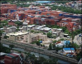
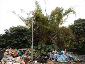
2.3.2 The northern extent of the Project area is bounded by Lau Fau Shan Road and hillslopes along Deep Bay Road. The Lau Fau Shan area is located in the northern Project area and is physically characterised by a series of knolls, uplands and hills. The uplands benefit from a moderate intensity of tree cover. Low lying areas are more sparsely vegetated and are occupied by clusters of New Territories Exempted Houses, informal basic housing, and a cluster of modern low rise developments. Lau Fau Shan has long been the local centre for oyster farming and fishing activities and the centre is well known for its seafood market and restaurant trade. A great variety of cultural/historical and natural scenic spots can also be found in the La Fau Shan area.
2.3.3 Areas within the northern part of the Project area have been cleared for brownfield operations. These uses permeate a significant proportion of the northern and central parts of the Project area (approximately 200 ha of land within the NDA were being used for brownfield operations at the time of writing), creating severe planning blight. Container storage and the storage of plant and vehicles are the principal uses. Container storage tends to fall into two categories: short- to medium-term container storage where containers are moved on and off site on a regular basis and long-term storage where containers are rarely moved off site. The latter condition is readily perceptible in relation to a number of sites. It is notable that containers are stored to six or more boxes high.
|
|
|
Large areas occupied by brownfield operations |
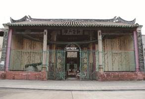
Built heritage within villages |
2.3.4
The northern and central parts of the Project
area are also occupied by a number of traditional villages such as Fung Kong
Tsuen, Ha Tsuen Shi, Sik Kong Wai, San Wai and Tung Tau Tsuen, etc. The scale and intensity is consistent with
village type development throughout the NWNT.
There is particular cultural heritage value identified
within these traditional villages.
Many elements of vernacular Chinese rural housing of the Qing dynasty
are preserved in the area.
Southern Project Area
2.3.5 The southern part of the Project area is significantly dissected by existing road and rail infrastructure. This has a significant impact on the morphology of this area and in combination with other transport routes effectively subdivides the area into definable parts.
2.3.6 The southern part of the Project area and particularly those located to the north of Castle Peak Road are currently committed to developments and land uses of various scales and character. Domestic structures, non-domestic structures and brownfield sites mainly open storage, warehouse and workshops are particularly prevalent within the southwestern parts of the Project area. The domestic structures in these areas are widely dispersed and some of them are impoverished temporary structures, intermingled with many non-domestic temporary structures. Some domestic structures are also converted from abandoned farm structures. The southeastern part of the Project area contrasts significantly with the preceding areas. A series of recent developments have been introduced to the area.
|
|
|
Open storage near villages |
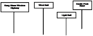
Area subdivided by Kong Sham Western Highway, West Rail, Light Rail and Castle Peak Road |
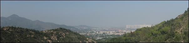
2.3.7 Land at the western Project area is formed of rolling uplands and lowlands linked to Castle Peak and its associated hillsides. Intermittent developments including industrial uses and infrastructural facilities are located adjacent to the west of KSWH. A large area of hillslopes is designated as “Conservation Area” (“CA”) on the extant Outline Zoning Plans (OZP), which comprises mainly shrubland and grassland, as well as some natural watercourses and small patches of village/orchard and plantation. The physical terrain restricts development in this area.
2.3.8 A mosaic of brownfields sites (e.g. recycling yards), vegetated knolls (with graves) and a small amount of agricultural land is located east of the KSWH. The effects of the brownfield sites on the environment are evident through disturbance to a local egretry near San Sang San Tsuen and direct discharge of effluent into local channels/watercourses.
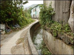
Egretry disturbed by brownfield activities Modified watercourse receiving effluent from adjacent properties
Vegetated hillslopes at the back of the
Project area
Eastern Project Area
2.3.9 The TSW Main Channel, which is a wide concrete-lined channel, forms the northeastern boundary of the Project. In the eastern Project area, Kiu Tau Wai industrial area is located to the south of the existing West Rail TSW Station (TSW Station) and TSW Light Rail Transit (LRT) Station. This area comprises of a number of low-rise industrial buildings which are mainly used for logistics, vehicle testing, warehouse and other general industrial uses.
2.3.10 A series of open areas located within and adjacent to Kiu Tau Wai and Hung Uk Tsuen have been converted for the use of industries and open storage. The mix of land uses within the area has created industrial / residential interface issues.
Rural Industry and open storage near villages Concrete-lined banks of the Tin Shui Wai
Main Channel
Constraints and Opportunities for Project
Development
2.3.11 The Project commands a geographically favourable location which provides opportunities for the area to develop as the regional centre of the NWNT with new residential and economic developments. However, a number of existing infrastructure and social and environmental features also impose constraints to the Project development.
Development
Opportunities
2.3.12 The Yuen Long Highway to the southeast and KSWH and Shenzhen Bay Bridge to the west connect the Project area to other parts of the Territory as well as Shenzhen through the strategic road network. The proposed strategic highway (Tuen Mun Western Bypass) which would connect the Project to the Tuen Mun – Chek Lap Kok Link and the other proposed new strategic highway could further augment accessibility to and from the Project area.
2.3.13 The proposed HSK Station along the existing West Rail Line and the existing TSW Station provide an opportunity to connect the Project area with Tuen Mun, TSW and Yuen Long New Towns and the urban area. These stations could also integrate the railway transport system in the overall land use framework. With the introduction of the environmentally friendly transport services (EFTS) in the Project and integration of land uses, the EFTS and railway stations could help maximise the use of public transport, thus minimising road traffic and reducing carbon emissions. The existing and planned railways and highway network is shown in Figure 2.1.
Ø Favourable Geographical Location
2.3.14 Being located close to the Tuen Mun, TSW and Yuen Long New Towns, Qianhai in Shenzhen, and connected by a number of existing and planned strategic transport links to other parts of the Territory, the Hong Kong International Airport and Shenzhen, there is potential for the Project to be developed as a regional centre and strategic employment hub. This geographically favourable location enables development of the area in promoting economic activities.
Ø Plentiful Natural and Landscape Features
2.3.15 A number of natural and landscape features within and surrounding the Project area could be utilised to create a quality living environment, such as uplands and lowlands, knolls, ridgeline/mountain backdrops of Yuen Tau Shan, woodlands, and San Sang San Tsuen egretry. Proper planning and land use zoning designation could help conserve the ecological value of these features and establish an integrated green network for the Project. Drainage channels running through the Project area offer good opportunities for creating distinct local character and providing passive recreational spaces along the riverside promenades.
2.3.16 The Project and its surroundings boast significant cultural heritage resources such as a number of Declared Monuments, graded historic buildings, sites of archaeological interest and the Ping Shan Heritage Trail. Appropriate planning and proper land use zoning designation could help incorporate these valuable resources into the Project for the benefits of existing and future residents.
Ø Land Resources
2.3.17 At present a large proportion of land is being utilised for the purpose of brownfield operations. The vast extent of brownfield operation in the area has created environmental and interface problems. However, with the aspiration to turn such land for more optimal uses, it provides opportunities for supporting the future development of Hong Kong.
Development Constraints
2.3.18 A number of constraints posed by the existing infrastructure and environment require careful consideration in the planning of the Project:
Ø Retention of the Traditional Villages and Permitted Burial Grounds
2.3.19 Retention of traditional villages (involving 19 villages and 1 village re-site) within the Project area precludes a large quantity of land from being developed. Potential interface issues between the villages and the proposed developments will need to be addressed. Permitted burial grounds located at the hillslopes in the western and northwestern Project area, and isolated knolls near the recognised villages would generally be retained.
Ø Proliferation of Brownfield Operations
2.3.20 At present, a large portion of land is being utilised for the purposes of brownfield operations including open storage, port back-up, construction material/machinery storage, car repair workshops, recycling yards, and rural workshops, etc. There are concerns regarding the negative externalities generated from such uses including the encroachment on residential developments leading to adverse interface issues, environmental degradation, adverse visual impacts and possible land contamination issues. While recognising that there may be opportunities to accommodate some of these uses to multi-storey buildings, given this is likely to be an incremental process, concerns pertaining to the interface of new developments with the existing brownfield operations during the interim period, needs to be addressed.
Ø Preservation of Natural and Landscape Features
2.3.21 Whilst the natural and landscape features are regarded as opportunities and may add value to the Project, their existence; however, may preclude land from being developed. Due consideration should be paid to these resources within and in the vicinity of the Project area to avoid/minimise adverse effects on their ecological and aesthetic value.
2.3.22 Areas adjoining TSW New Town along the TSW Main Channel are located in the flood plain where flooding is evident. Site formation and the drainage system should be designed to minimise flooding risk to the planned developments and the nearby existing settlements.
2.4
Description of the
Project (Revised Recommended Outline Development Plan (RODP))
Size,
Scale, Shape and Design of the Project
2.4.1 A key driver of the formulation of the Project has been to build a sustainable, people-oriented and balanced living and working community for Hong Kong people. The NDA will not be just a localised residential and employment cluster, but a regional centre serving as the Economic and Civic Hub of the NWNT. In the territorial context, the Project will give impetus to foster Hong Kong’s economic development and growth. The size of the Project is approximately 714 hectares and the total population and employment opportunities, upon full development, would be approximately 218,000 and 150,000, respectively.
2.4.2 An overview of the key planning elements and land uses forming the basis of the Revised RODP is provided in Table 2.1 and illustrated in Figure 2.2.
Table 2.1 Land Use Budget of the Revised RODP
|
Land
Use |
|
|
Residential Residential and Commercial / Residential |
80 (18%) 80 |
|
Economic Commercial (office, hotel and retail) Logistics Facilities Port Back Up, Storage and Workshop Uses Enterprise and Technology Park Industrial |
105 (24%) 22 37 24 9 13 |
|
Public Facilities Government, Institution or Community (other than Education) Education and Related Uses Public Utilities (Petrol Filling Station, Bus
Depot, Regional Plaza, Station, etc.) |
86(20%) 32 28 26 |
|
Open Space Regional Open Space District Open Space Local Open Space |
66(15%) 16 27 23 |
|
New Roads and
Amenity New Roads Amenity |
104(23%) 86 18 |
|
Total |
|
|
Others Existing Road and River Channel Green Belt (Preserved Knolls & Hillslopes) Retained Existing/ Committed Development
(including villages) |
70 54 149 |
|
Grand Total |
714 |
“Residential”
2.4.3 Under the Revised RODP, the approximate 61,000 new residential units will house an estimated new population of approximately 176,000 persons. With the existing population and population from the planned/committed residential developments within the Project area, the overall population is projected to be around 218,000 persons upon full development. The public:private housing mix is about 51:49.
“Commercial”
2.4.4 A number of sites are zoned “Commercial” (“C”) within the Project area. They are located either around the strategic locations of the proposed HSK Station, the existing TSW Station or near the tourism node of Lau Fau Shan. The planning intention of those “C” zones around the proposed HSK Station and the existing TSW Station is primarily for commercial developments, which may include offices, hotels, shops and services, places of entertainment and eating places, for reinforcing the areas as regional/district commercial nodes. For the “C” zone in the Lau Fau Shan area, it is intended primarily for commercial developments which may include shops and services, eating places and public car parks, functioning mainly as local commercial node serving the immediate tourism and recreation node and neighbourhood.
“Government”
2.4.5 The planning intention of the “Government” (”G”) zone is to reserve sites for provision of Government facilities such as police station, fire station, hospital, Government offices and magistracy, etc. The provision of Government facilities has been planned in response to relevant departments’ requests and in accordance with the Hong Kong Planning Standards and Guidelines. The overall Government provision would be adequate to serve the planned population for the Project.
“Institution and Community”
2.4.6 Three sites (Sites 1-26, 4-30 and 5-44) are designated as “Institution or Community” (“I/C”) on the Revised RODP to reflect the existing uses (i.e. the existing residential care homes for the elderly and two churches respectively).
“Education”
2.4.7 Schools will be provided within the “Education” (“E”) zone within the Project area. In general, developments at these sites are subject to a maximum building height of 8 storeys.
“Village Type Development”
2.4.8 All of the traditional villages will be retained under the “Village Type Development” (“V”) zone
2.4.9 There are generally no development within the “V” zone, except for the existing river channel near Tin Sum Tsuen area which would be realigned to create a continuous comprehensive blue network in north-south direction within the Project area and to provide a continuous pedestrian walkway underneath the elevated WRL. To facilitate the proposal, some areas within the original “V” zone is rezoned to “District Open Space” (“DO”) and an area to the south of Tin Sum Tsuen with equivalent size is rezoned to “V” in compensation.
“Amenity”
2.4.10 The Project caters for a range of incidental green spaces which are landscaped for amenity. “Amenity” (“A”) strips will be provided alongside roads as far as possible to enhance the amenity and to serve as buffers between existing villages and new developments. They offer good opportunities for landscaping and tree planting.
“Green Belt”
2.4.11 “Green Belt” (“GB”) areas have been determined to primarily conserve the existing natural environment amid the built-up areas/at the urban fringe, to: i) safeguard it from encroachment by urban type development; ii) define the limits of urban and suburban development areas by natural features; iii) contain urban sprawl; as well as to iv) provide passive recreational outlets, with a general presumption against development.
“Regional Open Space”
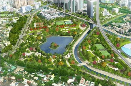
2.4.12 A number of “Regional Open Space” (“RO”) are planned within the Project area to provide regional recreational and leisure spaces. “RO” is intended primarily for the provision of facilities with a greater scope than the core activities and serve the wider recreational needs of the territorial population and tourists. It includes the area dedicated for the proposed Regional Town Park located at Sites 1-27 and 1-28.
“District Open Space”
2.4.13 A number of “DO” are planned within the Project area to provide recreational and leisure spaces. “DO” is intended primarily for the provision of outdoor open-air public space for active and/or passive recreational uses serving the needs of residents as well as the general public in the district. It includes the area dedicated for the riverside promenades and green corridors.
“Local Open Space”
2.4.14 “Local Open Space” (“LO”) is provided throughout the Project area and is in close proximity to residential areas and employment centres to serve local residents and workers.
“Industry”
2.4.15 A total area of about 13 ha to the west of KSWH is designated as “I” zone, which will provide land for general industrial development.
“Other Specified Uses”
2.4.16 This zoning covers land allocated for specific uses including mainly the following:
· Commercial and Residential – high-density mixed residential and commercial developments in close proximity to the proposed HSK Station and existing TSW Station.
· Commercial & Residential Development with Light Rail Facilities – medium density mixed residential and commercial developments incorporating some Light Rail facilities.
· Enterprise and Technology Park – development spaces for accommodating a variety of economic uses, such as innovation and technology uses, testing and certificate use, data centre use, modern industries and other related businesses and non-polluting industrial uses.
·
Logistics Facility – reserving land for
modern logistics facilities. This zone
is located just next to the KSWH to take advantage of being easily accessible
by strategic highways linking the HK International Airport,
Shenzhen and other parts of the New Territories.
2.4.17
Among these sites, Site 3-18 is intended for the
development of a “Logistics Facility cum EFTS Depot”. The EFTS Depot is proposed to be located on
the ground level, while the logistics facilities to be accommodated on the
floors above. The proposed location of
the EFTS Depot is located greater than 100 m from the nearest existing or
planned sensitive receiver.
· Port Back-Up, Storage and Workshop Uses (“PBU+SWU”) – multi-storey buildings to house some of the affected brownfield operations including the “PBU+SWU” operations. The reserved land in this zone also allows those industries requiring open air operations. The provision of these facilities is subject to further detailed study.
·
Regional Plaza – to reinforce the
identity of the “Regional Economic and Civic Hub” of the Project area, an area
(Site 4-14) around the proposed HSK Station is rezoned to “OU(Regional Plaza with
Leisure, Food and Beverages Uses)” on the Revised RODP. The Regional Plaza stretching from north to
south across the Town Centre will provide well-designed green walkways for
public enjoyment and serve as a civic space for public interaction. Good design integration between the proposed
HSK Station, with the shopping complexes and PTIs on both sides should be
adopted. To enhance vibrancy and
vitality of the Regional Plaza, supporting leisure, retail, food and beverage
facilities will also be provided.
· Education and Related Facilities – Site 4-17 is designated as “OU” annotated “Education and Related Facilities” with an aim to accommodate post-secondary educational uses, either for publicly funded or self-financing institutions for the purpose of providing academic facilities and/or student hostels, depending on the prevailing needs at the time.
· Commercial cum Public Transport Interchange (PTI) and Public Carpark – Site 2-23 is zoned as “OU” annotated “Commercial cum PTI and Public Carpark” for commercial development. A PTI and public carpark would also be provided at this site to serve the surroundings.
· Public Transport Interchange (PTI) – Site 5-5 is zoned as “OU(PTI)” to reflect the planned public transport terminus that aims to serve passengers from the TSW Station and TSW LRT stations.
· Sewage Treatment Works (STW) – Site 3-17 is designated as “OU” annotated “Sewage Treatment Works” to reflect the existing San Wai Sewage Treatment Works (SW STW), which will be upgraded by DSD under
The new HSK STW will be implemented in two phases to serve the different phases of development. The new HSK STW (Phase 1) at Site 3-26 will start operation before Stage 2 of the Project (i.e. 2031) to handle the sewage from the Project. The potential for using part of the land of the existing the SW STW for further expansion of the HSK STW (Phase 2) will also be explored, subject to review of the future population growth.
· Further details regarding the new HSK STW are provided in Section 2.4.52.
· Sewage Pumping Station (SPS) – Sites 1-23, 2-4, 2-34, 3-41, 3-48, and 4-35 are designated as “OU” annotated “Sewage Pumping Station” for six proposed/existing SPS for collecting sewage flow from the Project area and pumping the sewage to the STW. The four new SPS will have a design capacity of 27,000 m3 per day (SPS1), 39,500 m3 per day (SPS2), 11,000 m3 per day (SPS3), and 68,000 m3 per day (SPS4) and are described in Section 2.4.54.
· Fresh Water Service Reservoir (FWSR) and Flushing Water Service Reservoirs (FLWSR) – Site 5-40 with an area of about 1.2 ha is reserved for the development of a FWSR and a FLWSR. A FLWSR at Fung Kong Tsuen (Site 3-3) is also proposed as an alternative site.
· Refuse Transfer Station (RTS) – Site 3-12 has been proposed for the provision of a new RTS to support the new population’s waste generation. A Community Green Station is also co-located within the site to enhance environmental education and help collect different types of recyclables in the local community, which could provide a synergistic effect to achieve better operational efficiency.
· District Cooling System (DCS) – Two sites (Sites 1-24 and 4-18) have also been reserved in the vicinity of the proposed HSK Station and the existing TSW Station for possible development of a DCS – subject to further review.
· Railway Station – Site 4-34, located within the Regional Plaza, has been reserved for the proposed HSK Station. Key commercial activities and higher density residential developments are concentrated around 500 m of the proposed station. No detailed layout is available at this stage.
As the construction of the proposed HSK Station would be undertaken under a separate EIA, there is currently no detailed information regarding the layout. Any details required for the EIA assumptions are described in the relevant EIA section (e.g. Chapter 4 – Noise Impacts).
· Parking and Operational Facilities for EFTS – Site 2-29 is reserved for providing parking and operational facilities for the proposed EFTS.
· Refuse Collection Point (RCP), Electricity substation (ESS), Petrol Filling Station, Liquefied Petroleum Gas Filling Station, Flood Retention Facilities, Emergency Access Point, Telephone Exchange are to reflect the various planned/newly proposed public infrastructure/facilities within the Project area.
Transport Network
Road
Transport
2.4.18 The Project is presently serviced by several existing strategic primary and secondary accesses. Principal accesses include the Yuen Long Highway, Castle Peak Road and the KSWH. While the KSWH provides access to the Mainland, Yuen Long Highway and Castle Peak Road have a number of proposed road connections, and are capable of supporting the extent of population proposed within the Project area.
2.4.19 Secondary accesses that are currently servicing and providing access to the Project area include Tin Wah Road, Ping Ha Road and Tin Ying Road. Under the proposed planning framework, it is proposed to replace Tin Ying Road between its junction with Tin Wah Road and Ping Ha Road as well as downgrade Hung Tin Road. The future Project area would plan the traffic network holistically and have alternative roads, to resemble the function of Tin Ying Road and Hung Tin Road, as the new roads proposed to connect to KSWH. In addition, the Project proposal will consolidate the existing container operations in the northwestern part of Project area next to the KSWH and hence manage the traffic operations in the area and the traffic burden from the container operations on existing roads (e.g. Ping Ha Road). The intentions behind the proposed replacement of Tin Ying Road and downgrading of Hung Tin Road are as follows:
· to enhance the extent of land available for housing by reducing the extent of land occupied by roads;
· to increase the extent of land available for housing by reducing the environmental impacts that would otherwise occur with the retention of Tin Ying Road. Impacts would be confined to the upgraded Ping Ha Road;
· to liberate areas adjacent to the existing channel and to create a positive vehicle free recreational riverside edge; and
· to efficiently integrate with TSW New Town by removing the road barrier between the areas.
2.4.20 As a general principle, the layout of the new road network seeks to limit east to west vehicle penetration. The restriction of through passage has the following benefits:
· a reduction in vehicles crossing the Project area with consequential benefits to air quality;
· a reduction in noise impacts; and
· a reduction in the area occupied by roads thereby making land available for other uses.
2.4.21 In addition to the above proposals, the layout of roads has sought to provide convenient access to neighbourhoods within the Project area whilst discouraging “rat runs” or short-cuts through residential or other development areas. Thus, whilst the principal roads within the road hierarchy are often convenient direct routes, the lower tier roads are generally discontinuous. The avoidance of permitting through traffic is likely to have environmental benefits. In addition to the preceding, the disposition and arrangement of land use has been considered with the environmental impacts that can arise from traffic in mind. A particular strategy has been to locate land uses that attract heavy goods vehicles (HGV) to the west of the Project area adjacent to the KSWH. The intention is to limit HGV access from routes located to the west of the Project area and not permit access (restrictive signage would be beneficial in this respect) to the residential areas proposed within the Project area. This will ameliorate the impact of heavy traffic. The major components of the proposed road hierarchy (Figure 2.1) are as follows.
Primary
Distributor Roads (Dual 2 / Dual 3 Standard)
2.4.22 Road P1: Located under the KSWH, provides a service access to both the Special Industry areas and the new core area around the proposed HSK Station. Minor alignment changes have been proposed with the intention to bypass the mitigation ponds under Deep Bay Link (DBL) project located in the immediate vicinity of the road, opposite site 3-26. Road P1 is described in Section 2.4.40.
District
Distributor Roads (Dual 2 / Dual 3 Standards)
2.4.23 A total of eight Distributor Roads are proposed. All will provide a major role in servicing proposed land uses and existing developments (including villages where linkages have been provided). These are described in Section 2.4.43.
Local Roads
2.4.24 Local roads provide access into each development cell and also connect with private access roads in the proposed residential developments.
Existing
Roads
2.4.25 With the exception of Tin Ying Road and the present west to east linkages to the north of the Project area the alignment of the existing road system is largely retained. This will permit access to existing development.
2.4.26 The construction of the proposed new routes and the improvement of existing routes will be implemented progressively in accordance with the proposed area development programmes. All roads will be provided with footpaths of an appropriate size on each side of the carriageway. These will be of a sufficient size to permit tree planting and the passage of pedestrians. The Primary Distributor Roads will have a 3 m median that will be sufficient to accommodate tree planting. Locations of elevated or depressed roads are illustrated in Figure 2.1.
Public Transport
Rail Transport
2.4.27 Two forms of rail transport currently provide service to the Project area:
· West Rail Line; and
· Light Rail Transit.
Light Rail
Transit
2.4.28 This provides services to TSW New Town and its service area extends to Yuen Long and Tuen Mun along Castle Peak Road.
West Rail
Line
2.4.29 This provides a mass transit rail link that extends from TSW to Hong Kong’s Central Business District (a journey of less than 30 minutes). The alignment dissects the central southern section of the Project area. The alignment runs on a viaduct. Within the Project the running tracks upon the viaduct are at an elevation of between 19 mPD and 20 mPD. TSW Station is the only exiting West Rail station that is located within the Project area. Provision exists for the inclusion of a future HSK Station. Realisation of the station will be contingent on sufficient patronage being provided within the proposed Project area. The location of the proposed station is indicated on the Revised RODP (see Figure 2.2).
Environmentally
Friendly Transport Services – Subject to further review
2.4.30 The proposed EFTS traverses the core of residential, commercial and other land reserves within the Project area. The separation between stations is in walking distance to further facilitate public access. A modern, low profile tram system has been assumed for the EIA, but the system that will ultimately be used is subject to further study. The GTC reserve allocated to the tram will also be abutted by cycle and pedestrian routes. This will allow the public to cycle within vehicle free routes. The quality of the reserve will be enhanced through the application of high and low profile landscape treatments. A depot associated with the proposed EFTS at Site 3-18 is also included in the Revised RODP.
Franchised
Buses
2.4.31 There are currently no significant bus routes servicing the Project area except for a number of services that operate along Castle Peak Road. There is a large PTI located adjacent to TSW Station.
2.4.32 Full build-out of the population within the Project area, which is anticipated to be approximately 218,000 persons, will generate the need for an additional PTI to meet local requirements. This is proposed to be located adjacent to the proposed HSK Station and will be integrated within a property development, as well as in the northern part of the Project area in Site 2-23.
Pedestrian Walkway and Cycle Track Networks
Cycling
Provision
2.4.33
A
comprehensive cycling network will be provided along the majority of
major roads and the proposed EFTS alignment in the Project area. The
artery cycle track will be provided from the north along the TSW Main Channel
to the south connecting to the proposed HSK Station. Attractive streetscapes with roadside plantings will be created to provide
amenity, shade and safe and convenient at-grade crossings will be
provided. The alignment is
indicated in Figure
2.2.
Pedestrian
Infrastructure
2.4.34 Pedestrian footpaths of various widths have been provided along all major roads. Vehicle free pedestrian passage will also be provided along the arterial open space corridors that are proposed to follow the principal channels that dissect the Project area. Elevated crossings will be avoided where possible to enhance universal barrier free access. Given the gradients prevailing within the Project area ease of movement should be available to all.
Cultural
Heritage Trail
2.4.35 To promote the cultural heritage resources within and surrounding the Project, a cultural heritage trail is proposed. This trail is proposed to begin at the TSW Station and the proposed HSK Station and permeates through the Project, along the existing Open Space and “A” sites. The trail provides a safe and efficient amenity for people to explore many of the culturally significant areas in the Project area and is also intended to help promote these features and draw people to the area. The route of the heritage trail is depicted in Figure 2.2.
2.4.36 The heritage trail has been revised since the PODP stage as further investigation on the walking distance, concentration of built heritage and existing footpath network in Ha Tsuen area was undertaken. The proposed trail now reduces the extent of the trail to focus on a specific area (Ha Tsuen area) which accommodates a concentration of built heritage resources with existing footpaths along the proposed route. It is also anticipated that the heritage resources at Ha Tsuen, being retained as “V”, would not be altered and would remain in their current condition. The principle of the trail is similar to the existing Ping Shan Heritage Trail, in which the trail leads visitors to the villages and lets them explore the cultural landscape independently. It is understood that there are existing footpaths along the proposed route. It is also important to maintain the privacy of local residents. Some Declared Monuments have legal status, which could be (at appropriate hours and days) opened to public, but not all graded buildings welcome visitors. Many of the cultural heritage resources are currently occupied as residence, worshipping places such as ancestral halls and temples, or private storage house. In the light of this, drawing the trail to the level of individual houses is not recommended.
2.4.37 We also recommend keeping the trail short and focused to also limit the implementation and maintenance requirements. Given the proposed cycle track and the provision of pedestrian walkways within the Project area, a connection with the nearby stations and the heritage features in Ping Shan is available, albeit, we do not recommend that these form part of the heritage trail.
Eco-Trail
2.4.38 To let the public appreciate the natural, ecological and landscape resources within and in the surroundings of the Project such as knolls, mountain backdrop of Yuen Tau Shan, and open space provision, an Eco-trail is proposed to link up the Regional Town Park with the above resources and the hiking trails in Yuen Tai Shan (Figure 2.2).
2.4.39
Based on the Revised RODP, the Project would
comprise the following designated projects by virtue of items A.1, A.2, A.3,
A.8, A.9, B.5, F.1, F.3(b), F.4, G.2 and Q.1, of Schedule 2 of the EIAO. Locations are illustrated in Figures
1.2 and 1.3.
DP 1 – Construction of New Primary Distributor Road (Road P1)
2.4.40 The majority of the new primary distributor road (Road P1) located under the existing KSWH at the western Project area (approximately 3.2 km in length), provides a service access with 2 lanes per direction to both the “I” areas and the new core area around the proposed HSK Station. Alignment options have been reviewed to minimise impacts on the DBL project mitigation ponds located in the immediate vicinity of the road, opposite Site 3-26.
2.4.41 The at-grade alignment will have several connections to the proposed district distributor roads (Road D1/D5/D6/D7/D8). Two pairs of slip roads will be constructed to connect between the at-grade Road P1 and existing KSWH. In addition, a pair of slip roads along Road P1 will be constructed between the existing KSWH and at-grade Road D6 to facilitate the traffic connection at north western part of the Project area.
2.4.42 The general layout and cross-sections of Road P1 are presented in Figures 2.3.1 – 2.3.5 and Figures 2.12.1, respectively.
DP2 – Construction of Eight New Distributor Roads (Road D1 to D8)
2.4.43 A total of eight Distributor Roads are proposed. All will provide a major role in servicing proposed land uses and existing developments (including villages where linkages have been provided). These comprise:
· Road D1: This road provides a partly dual three and partly dual two, west to east primary connection at the northern part of the Project area linking TSW with the KSWH and providing links to District Distributors that provide the secondary links to the south of the Project area. The local road from a section of Road D1 near Lau Fau Shan to serve the residential sites and commercial sites in the northern part of the Project area will be restricted to private cars access only. A section of Road D1 from KSWH to road junction of Road D4/D3/D1 will be partly depressed and partly decked-over to allow crossing of the EFTS alignment. A section of Road D1 near the roundabout with Tin Wah Road will be a bridge structure (not greater than 30 m in length between abutments) to allow the local road to/from residential sites in the northern part of the Project area in parallel with Lau Fau Shan Road to the end of Site 2-1.
The general layout and cross-section of Road D1 are presented in Figures 2.4.1 – 2.4.4 and Figure 2.12.1, respectively.
· Road D2: Comprises a north-south primary route that links to Ping Ha Road and Hung Tin Road. Road D2 is planned to dual 2 standards by widening of existing Ping Ha Road to enhance the magnitude of residential development and reduce the environmental adverse noise impact that is realisable in the north east of the Project area. The link will accommodate the traffic capacity currently carried along the Tin Ying Road and Ping Ha Road and also has the capacity to service existing and proposed development. Most of the Road D2 is constructed at-grade, except a section of approximately 450 m which is a depressed road in order to improve pedestrian connectivity between the residential Sites 1-5, 1-6 and 2-31.
The general layout and cross-section of Road D2 are presented in and Figures 2.5.1 – 2.5.3 and Figure 2.12.1, respectively.
· Road D3: Provides a link between Road D4/D1 and Road D5. A depressed road will be constructed near the roundabout of Road D4/D1 to avoid reduction on the traffic flow efficiency to and from Road D1. A section of Road D3 will be constructed in abutment for connection from slip road from KSWH to the at-grade section of Road D3.
The general layout and cross-section of Road D3 and the slip road are presented in Figures 2.6.1 – 2.6.2 and Figure 2.12.2, respectively.
· Road D4: Provides a link between Road D1/D3 to Road D2 to facilitate an eastward connection to TSW New Town and Castle Peak Road via Road D4. This route will serve to alleviate the pressure on other west to east links. A section of Road D4 of approximately 300 m length will be constructed as depressed road with partial pedestrian decking-over to facilitate access, and thus increasing connectivity between Sites 2-30 and 2-32.
The general layout and cross-section of Road D4 are presented in Figures 2.7.1 – 2.7.2 and Figures 2.12.2 and 2.12.3, respectively.
· Road D5: Provides a link between the services areas (e.g. Special Industry (Logistics Facility)) and connects to Road P1 in the west and Tin Ha Road in the east. The whole section of Road D5 will be at-grade with a roundabout with Road D3.
The general layout and cross-section of Road D5 are presented in Figures 2.8.1 – 2.8.2, and Figure 2.12.3, respectively.
· Road D6: Connects with Road D8 along its alignment. The route will play a major role in servicing the proposed HSK Station and related development as well as the proposed commercial sites and mixed commercial/residential development. To avoid conflict to pedestrian activity in the Regional Plaza near the proposed HSK Station, half of Road R6 will be constructed in depressed road of approximate 550 m length with partial decking-over in the Regional Plaza section.
The general layout and cross-section of Road D6 are presented in Figures 2.9.1 – 2.9.3 and Figure 2.12.3, respectively.
·
Road D7:
Road D7 provides access from Road P1 to the commercial sites at Sites 4-12,
4-13 and 4-16. The general layout and
cross-section of Road D7 are presented in Figure
2.10 and Figure
2.12.3, respectively.
· Road D8: Road D8 provides a connection between the proposed Road P1 and Castle Peak Road. The route will provide an important west to east link whilst also providing a major means of access to the proposed HSK Station, the civic node at Site 4-31, and the commercial and residential developments located east of the proposed HSK Station. The road will be constructed at-grade with a depressed EFTS crossing under Road D8.
The general layout and cross-section of Road D8 are presented in Figures 2.11.1 – 2.11.2 and Figure 2.12.3, respectively.
DP3 – Construction of New West Rail Hung Shui Kiu Station
2.4.44
A new WRL Station will be built at the south of
the Project area. This railway station will be important for transportation in
the southern part of Project area in addition to the road traffic at Road P1
and Castle Peak Road. Railway associated facilities such as ventilation shafts
etc. would be located in the vicinity of the station. As the construction of the station would be
undertaken under a separate EIA, station details are not currently
available. However, a proposed schematic
layout of the station is proposed for the purpose of this EIA (Figure 4.8.1).
Any details required for the EIA assumptions are described in the relevant EIA
sections (e.g. Chapter 4 – Noise Impact).
DP4 – Construction of Environmentally
Friendly Transport Services – subject to further review
2.4.45 The proposed EFTS traverses the core residential, commercial and other land reserves within the Project area. The separation between stations is walking distance to facilitate public access. A modern low profile tram system has been assumed for the purpose of the EIA; however, the system that will ultimately be used is subject to further study. The GTC reserve allocated to the tram will be also abutted by cycle and pedestrian routes. This will allow the public to cycle within vehicle free routes. The quality of the reserve will be enhanced through the application of high and low profile landscape treatments. A depot associated with the proposed EFTS is located at Site 3-18 and a parking and operation facilities for EFTS is located at Site 2-29. Most of the alignment of the EFTS will be constructed at-grade, except some sections will be depressed and elevated at junctions within the proposed carriageway.
DP5
– Construction of Slip Roads between: Road D8 Junction and Existing Castle Peak
Road; Junction of D8/P1 and Junction of D7/P1; and KSWH Connection to Road D3
2.4.46 The proposed slip roads have a length of more than 100 m in length between abutments. Two pairs of slip roads will be constructed near the two roundabouts of Road D8 and Road D7. They provide connection between at-grade Road P1 and existing elevated KSWH in order to improve the traffic connectivity to the Project area. Another pair of slip roads will be constructed from the existing KSWH to at-grade Road D3 to provide direct traffic connection to the port-back up areas and the logistic facilities at the western part of the Project.
DP6 – Construction of Partly Depressed and Partly Decked-over Roads Located at Road D2, D4 and D6
2.4.47 Some sections of Road D2, D4 and D6 are enclosed by decking above and by structure on the side for more than 100 m and hence classified as DP under Item A.9 Part 1, Schedule 2 of the EIAO.
2.4.48 The district open space (Site 2-32) located to the south of Road D4 and west of Road D2 is intended to act as a buffer between new developments and the villages to the south, and provides flexibility for community farming and farming markets. This district open space and the proposed residential sites are however separated by Roads D2 and D4. A section of the Road D2 is therefore decked-over for approximately 450 m with intermittent openings to improve pedestrian access/connectivity between the residential sites near the TSW Main Channel to “LO”, via Site 2-31 and crossing Road D4. Similarly, to enhance connectivity with the district open space (Site 2-32), it is proposed to deck over approximately 250 m of Road D4 in order to provide pedestrian crossing and flow from north to south across Road D4.
2.4.49 Approximately 300 m with intermittent openings of Road D6 would be decked-over near the proposed Regional Plaza near the proposed HSK Station. The decked-over structure is intended to maximise the area of Regional Plaza and allow pedestrian crossing to the EFTS station and the western part of development. In particular, a 20 m wide pedestrian street lined with retail shops, cafés and restaurants is proposed as a major pedestrian connection between the communities to the south of Castle Peak Road and the Town Centre. The proposed arrangement of depressing and decking over a section of Road D6 will allow seamless at-grade crossing between commercial complexes on two sides of the proposed HSK Station and provide a pleasant walking environment within the Town Centre.
DP7 – Construction of a New Container Back-up and Storage Area (Sites 3-1, 3-4, 3-5, 3-13 and 3-14) – subject to further review
2.4.50 The western part of the Project is planned to serve as “PBU” and logistic facilities area to accommodate brownfield operations within the Project area. It is intended to locate these facilities at the west of the Project area to minimise interface issues with planned residential development and communities. The details of this development (i.e. size/area of container back-up area, container storage area) would be determined at the detailed design stage. This development would be a potential designated project where the area was more than 5 ha and within 300 m of an existing or planned receiver (e.g. Sites 3-1, 3-4, 3-5, 3-13 and 3-14).
DP8 – Construction of New HSK Sewage Treatment Works (Site 3-26 and Part of Existing SW STW)
2.4.51 As the planned SW STW – Phase 1 is not designed to cater for the additional flow generated from the Project, a new HSK STW will be provided to handle the sewage arising from the new population and employment in the Project area. The new HSK STW will be implemented in two phases to serve the different phases of development.
2.4.52 The new HSK STW (Phase 1) will start operation before Stage 2 of the Project (i.e. 2031) to handle the sewage from the Project using Site 3-26. The potential for using part of the land of the existing the SW STW for further expansion of the HSK STW (Phase 2) will also be explored, subject to review of the future population growth. The new HSK STW will be constructed with tertiary treatment for reuse of reclaimed water and secondary plus treatment (with UV disinfection and 75% nitrogen removal) for disposal of effluent with an ultimate design capacity of approximately 85,500 m3 per day.
2.4.53 As the construction of the new HSK STW would be undertaken under a separate EIA, there is currently no information regarding the layout. Any details required for the EIA assumptions are described in the relevant EIA sections (e.g. Chapter 6 – Sewage and Sewerage Treatment Implications).
DP9 – Construction of Four New Sewage Pumping Stations
2.4.54 The sewerage arrangement for the intermediate and ultimate development stages, include four SPS (SPS1, SPS2, SPS3 and SPS4), which will be required to convey the sewage to SW STW- phase 1 and the proposed new HSK STW. The four new SPS will be implemented in two stages and designed with a capacity of 27,000 m3 per day (SPS1), 39,500 m3 per day (SPS2), 11,000 m3 per day (SPS3), and 68,000 m3 per day (SPS4) (Sites 2-34, 3-41, 3-48 and 4-35, respectively).
2.4.55 Construction of SPS1 and SPS2 (general layout presented in Figures 2.14 and 2.15, respectively) will be carried out in the advance works stage in order to cope with the completion of advance works for the Project. SPS1 is designated to convey sewage from the southern Project area next to Castle Peak Road to SPS2 and then to SW STW. SPS2 sewage catchment also includes the western Project area next to KSWH. These two SPSs are tentatively scheduled to be completed by 2029.
2.4.56 Construction of SPS3 and SPS4 (general layout presented in Figures 2.16 and 2.17, respectively) will be carried out in the development stage 2 and 3, respectively. SPS3 will receive sewage flow from the middle part of the Project area and then convey it to SPS2 for further pumping to the future new HSK STW. SPS4 will collect sewage from northern part of the Project area and divert the sewage from Tin Wah Road to SW STW through a proposed new rising main. These two SPSs are tentatively scheduled to be completed by 2031.
2.4.57 Since all these SPSs are with an installed capacity of more than 2000 m3 per day and are located within 150 m from existing and/or planned residential area or educational institution, these SPSs are classified as DPs under Item F.3, Part 1, Schedule 2 of the EIAO.
DP10 – Construction of Flushing Water Service Reservoirs for Reuse of Reclaimed Water at Tan Kwai Tsuen and Fung Kong Tsuen
2.4.58 In order to achieve a sustainable development, reclaimed water from the sewage treatment plant will be reused for flushing water serving the Project. To facilitate the reuse of reclaimed water, service reservoirs at Tan Kwai Tsuen and Fung Kong Tsuen would be constructed (Sites 5-40 and 3-3).
DP11 – Construction of One Refuse Transfer Station
2.4.59 In the northern part of the Project area along the KSWH, Site 3-12 has been proposed for the provision of a new “RTS” to cope with the new population waste generation. A Community Green Station is also proposed to co-locate within the site to enhance environmental education and help collect different types of recyclables in the local community, which could provide synergistic effect to achieve better operational efficiency.
2.4.60 A north bound slip road from KSWH is proposed to provide direct access via Road D4 to west part of the Project area which will be located next to KSWH. The slip road and part of Road P1 will be partially located in the “CA” designation of Yuen Tau Shan. The alignment of Road P1 and the slip road will be constructed along the reinforced concrete flood storage ponds to avoid loss of natural/semi-natural habitats.
2.4.61 The general layout and cross-section of slip road are presented in Figure 2.3.4 and Figure 2.12.2, respectively.
Environmental
Acceptability of the Schedule 2 Designated Projects
2.4.62 The EIA has provided an assessment of the potential environmental impacts associated with the construction and operation of the Project, based on the engineering design information available at this stage. This has included specific assessment for the Schedule 2 Designated Projects (DP) subject to environmental permit application under this Study (DP1, DP2, DP5, DP6, DP9 and DP12) within the individual chapters (Table 2.2).
Table 2.2 Assessment of Schedule 2 Designated Projects
Subject to Environmental Permit Application
|
Schedule 2 Designated Project Subject to EP
Application |
Section Reference in EIA Report |
|
|
DP1 |
Air
Quality: Section
3.13 |
|
|
Noise
Impact: Section
4.11 |
||
|
Water
Quality: Sections
5.10, 5.11 and 5.17 |
||
|
Sewage
and Sewage Implication: N/A |
||
|
Waste
Implication: Section
7.8.1 |
||
|
Land
Contamination: Section
8.11 |
||
|
Ecology: Section
9.9 |
||
|
Fisheries: Section
10.8.1 |
||
|
Landscape
and Visual Impact: Section
11.6A |
||
|
Cultural
Heritage: N/A |
||
|
DP2 |
Air
Quality: Section
3.13 |
|
|
Noise
Impact: Section
4.11 |
||
|
Water
Quality: Sections
5.10, 5.11 and 5.17 |
||
|
Sewage
and Sewage Implication: N/A |
||
|
Waste
Implication: Section
7.8.1 |
||
|
Land
Contamination: Section
8.11 |
||
|
Ecology: Section
9.9 |
||
|
Fisheries: Section
10.8.1 |
||
|
Landscape
and Visual Impact: Section
11.6A |
||
|
Cultural
Heritage: Section
12.10.3 |
||
|
DP5 |
A road or railway bridge more than 100 m in
length between abutments |
Air
Quality: Section
3.13 |
|
Noise
Impact: Section
4.11 |
||
|
Water
Quality: Sections
5.10, 5.11 and 5.17 |
||
|
Sewage
and Sewage Implication: N/A |
||
|
Waste
Implication: Section
7.8.1 |
||
|
Land
Contamination: Section
8.11 |
||
|
Ecology: Section
9.9 |
||
|
Fisheries: Section
10.8.1 |
||
|
Landscape
and Visual Impact: Section
11.6A |
||
|
Cultural
Heritage: N/A |
||
|
DP6 |
A road fully enclosed by decking above and by
structure on the sides for more than 100 m |
Air
Quality: Section
3.13 |
|
Noise
Impact: Section
4.11 |
||
|
Water
Quality: Sections
5.10, 5.11 and 5.17 |
||
|
Sewage
and Sewage Implication: N/A |
||
|
Waste
Implication: Section
7.8.1 |
||
|
Land
Contamination: Section
8.11 |
||
|
Ecology: Section
9.9 |
||
|
Fisheries: Section
10.8.1 |
||
|
Landscape
and Visual Impact: Section
11.6A |
||
|
Cultural
Heritage: N/A |
||
|
DP9 |
A sewage pumping station –
|
Air
Quality: Section
3.13 |
|
Noise
Impact: Section
4.11 |
||
|
Water
Quality: Sections
5.10, 5.11 and 5.17 |
||
|
Sewage
and Sewage Implication: Section
6.9 |
||
|
Waste
Implication: Section
7.8.1 |
||
|
Land
Contamination: Section
8.11 |
||
|
Ecology: Section
9.9 |
||
|
Fisheries: Section
10.8.1 |
||
|
Landscape
and Visual Impact: Section
11.6B |
||
|
Cultural
Heritage: N/A |
||
|
DP12 |
Air
Quality: Section
3.13 |
|
|
Noise
Impact: Section
4.11 |
||
|
Water
Quality: Sections
5.10, 5.11 and 5.17 |
||
|
Sewage
and Sewage Implication: N/A |
||
|
Waste
Implication: Section
7.8.1 |
||
|
Land
Contamination: Section
8.11 |
||
|
Ecology: Section
9.9 |
||
|
Fisheries: Section
10.8.1 |
||
|
Landscape
and Visual Impact: Section
11.6A |
||
|
Cultural
Heritage: N/A |
2.5
Project Benefits and Green
Initiatives
Green Initiatives
2.5.1 As a green city, the Project would adopt a sustainable and energy saving strategy in respect of town planning, urban design, transportation, and blue-green infrastructure, so as to achieve energy efficiency, carbon emission reduction and sustainable living, as far as practicable. A key aspect to achieving this is to minimise road transport-use and promote green mobility. Within the Project, major population, economic activities and community facilities have been concentrated within walking distance of mass transit and public transport nodes. Green mobility is promoted through the introduction of the GTC comprising the EFTS, and a comprehensive pedestrian walkways and cycle tracks network.
2.5.2 The comprehensive pedestrian walkways and cycle tracks network would be supported by facilities such as underground cycle parking areas, bicycle rental system, cycle and footbridges, crossing facilities and rest areas to promote walkability and cycle friendliness.
|
|
|
Conceptual
diagram of GTC and environmentally-friendly modes of transport
|
|
2.5.3 In addition to transport, a total water management concept and arrangement including sewerage, drainage and water resources infrastructure is proposed for integration into the Project. To promote sustainable use of water, opportunities for using reclaimed water and harvested rainwater for non-potable purposes such as toilet flushing and irrigation within the Project will be explored. Rainwater is proposed to be partly collected and reused as irrigation water. Also roadside bioretention swales are proposed to attenuate any surface run-off to the downstream areas. Blue-green infrastructure, such as a flood retention facility with possible underground storage tank, will be used to temporarily store any flood water collected at low-lying villages. The flood retention facilities’ integrated design with the Open Space system would provide for opportunities for passive recreation activities and public enjoyment, as well as a potential microclimate cooling mechanism.
Conceptual diagram of flood retention lake proposed in the Regional Town Park and revitalised river channels
2.5.4 It is also proposed to revitalise the river channel system by adopting a comprehensive regeneration design along the whole system. The ecology of the channel would be enhanced and the riverside promenade with pedestrian walkways and cycle tracks introduced. To inject vitality into the riverside, the promenade will be extended along the channels to link the Regional Town Park and Regional Plaza. The regenerated channels will be the major green spines, breezeways and view corridors and will enable better integration between different neighbourhoods and with the adjacent TSW New Town.
2.5.5 Other green initiatives, which are proposed include the provision of a community green station for environmental education and collection of recyclables from the local community; and promotion of energy efficient buildings and installations. The use of a DCS for non-domestic developments, and the establishment of an information and communication technology (ICT) platform to coordinate different city functions for enhancing city management and convenience of residents and businesses would also be explored.
2.5.6 These proposed green initiatives will be implemented for future developments subject to further review.
2.5.7 The proposed green initiatives have been summarised in Table 2.3, under the following themes: Green Mobility, Total Water Management, Solid Waste Management, Sustainable Drainage System, and Green Energy Saving.
Table 2.3 Proposed
Green Initiatives
|
Themes |
Green Initiatives |
|
Green Mobility |
Create compact and walkable city by
concentrating population, key economic activities and major community facilities
within walking distance of mass transit and public transport nodes |
|
Create local communities with easily
accessible daily necessities to promote walking |
|
|
Provide comprehensive, convenient and attractive
cycle track and pedestrian walkway network with supporting facilities such as
underground cycle parking areas, bicycle rental system, cycle and
footbridges, crossing facilities and rest areas, etc. to promote walkability
and cycle friendliness |
|
|
Provide GTC that connects the residential
clusters with the logistics, enterprise and technology quarter, railway
stations and key community facilities to minimise road traffic and carbon
emission |
|
|
Total Water Management |
Incorporate tertiary treatment at the
proposed HSK STW allowing reclaimed water to be polished for reuse, thus
minimising the need for long-distance effluent export |
|
Explore the use of biogas produced from
sludge digestion for electricity generation |
|
|
Explore the use of reclaimed water for
non-potable purposes such as toilet flushing and irrigation |
|
|
Provide bioretention swales along roadside |
|
|
Solid Waste Management |
Co-locate Community Green Station with the
RTS for environmental education purpose and convenient collection of
recyclables from the local community, providing synergy to achieve better
operational efficiency and environmental sustainability |
|
Explore adoption of automatic refuse
collection system and organic waste treatment facilities |
|
|
Sustainable Drainage System |
Provide flood retention facilities as a
regulating measures to overall drainage system and as a microclimate cooling
mechanism through integrated design with the open space system for public
enjoyment |
|
Collect rainwater for non-potable purposes |
|
|
Revitalise the river channel system of
Project area by replacing Tin Ying Road abutting the channel and adopting
comprehensive regeneration design along the whole system. The ecological system in the channel will
be enhanced and riverside promenade with pedestrian walkways and cycle tracks
will be introduced |
|
|
Inject vitality to the riverside by
extending the promenade all along the river channels linking with the
Regional Town Park and Regional Plaza and creating corridors for activities |
|
|
Regenerate river channels as the major
green spines, breezeways and view corridors and enable better integration
between different neighbourhoods and with the adjacent TSW New Town |
|
|
Green Energy Saving |
Explore the use of DCS for non-domestic
developments |
|
Encourage environmentally friendly building
design and materials, and energy-saving installations |
|
|
Promote certification under BEAM Plus or
other equivalent accreditations for all new buildings |
|
|
Establish ICT platform to coordinate
different city functions to enhance city management and convenience of
residents and business activities |
|
|
Explore development of community gardens in
open space and amenity areas to promote green living |
Benefits of the Project
2.5.8 The Project aspires to turn the existing vast extent of brownfield sites including open storage, port back-up, construction material/machinery storage, car repair workshops, recycling yards, and rural workshops, etc., which have created considerable environmental, traffic, visual, and other nuisance, to more optimal uses and better land utilisation for future development of Hong Kong. The development of the Project could result in the following benefits and bring in environmental initiatives:
Direct
Benefits
·
Alleviate the current housing shortfall and
meet the long-term housing needs of Hong Kong – The
Project will provide about 61,000 new flats (about half for public housing).
This will provide a variety of housing types, responding to the needs of the
community and therefore engendering a sense of belonging for people and
enriching their quality of life. The proposed public/private housing mix in the
Project will also help to redress the existing imbalance of public/private
housing in the TSW New Town.
·
Create job opportunities –
Approximately 150,000 new job places would be generated upon full development
of the Project, through a mix of commercial, business, industrial, community
and government land uses. This would help to address the over concentration of
commercial activities and employment opportunities in the main urban areas,
boost the vibrancy of local communities, meet the short fall of jobs in TSW New
Town, as well as ease congestion at the commuting corridors between the New
Territories and the urban areas.
· Sustain Economic Growth – Concentrated development intensity of the commercial sites at the proposed HSK Station and the existing TSW Station reinforces their respective functions as “Regional Economic and Civic Hub” and “District Commercial Node”. The proposed commercial development around the two stations would help relieve the already congested town centres of nearby Yuen Long and Tuen Mun New Towns. In each individual residential neighbourhood, street shops and local retailing services will be provided to meet the residents’ daily necessities and enhance street vibrancy.
· Provide Spaces for Special Industry – The “Logistics, Enterprise and Technology Quarter” at the north-western part of the Project area provides another major employment cluster. About 37 ha of land are reserved for high value-added modern logistics and about 9 ha are reserved for uses such as innovation and technology, testing and certification, data centre and other related business and non-polluting industrial activities. An approximately 13 ha industrial zone is also planned at the western fringe of the Project area near KSWH for general industrial uses.
· Provide “Government, Institution and Community” (“G/IC”) facilities – The planning for the Project is people-oriented. The requirements of the surrounding areas including TSW have been taken into account in the provision of “G/IC” facilities. The Project has proposed a series of civic elements and a wide range of “G/IC” facilities including hospital, clinics, magistracy, community halls, performance venue, wet markets, youth centres, educational facilities, social welfare facilities, sports and recreation facilities, etc.
Environmental
Initiatives
· Minimise Industrial / Residential Interface – At present, the proliferation of brownfield operations in Project area has created considerable environmental, traffic, visual, flooding and other problems. One of the objectives of developing the Project is to convert these brownfield sites to more optimal uses and improve the overall environment of the area. Approximately 24 ha of land at the northern fringe of the Project area is reserved for “Other Specified Uses” annotated “Port Back-up, Storage and Workshop Uses” (“OU(PBU+SWU)”). This area may accommodate some of the existing brownfield operations through the possible development of multi-storey buildings or other land efficient means. The provision of this dedicated area will help to alleviate existing industrial/residential interface issues resulting from existing brownfield operations. In addition, new roads will be provided to directly connect this area to KSWH thereby eliminating the current movement of heavy goods vehicles (HGV) through built-up areas including residential areas.
·
Create Compact and Walkable City – For
sustainable development of the Project, one of the key planning concepts
is to minimise
traffic generation. Major population, economic activities and community
facilities will be concentrated within walking distance of mass transit and
public transport nodes. Green mobility is promoted within the Project through
the introduction of the GTC comprising the EFTS, cycle tracks and pedestrian
walkways. This would allow the community to have better
accessibility to the EFTS which would in turn help to reduce road based traffic
and hence their associated vehicular noise and emission.
2.5.9
A comprehensive and convenient pedestrian
walkway and cycle track network is also planned throughout the Project area.
Key destinations, such as proposed railway/EFTS stations and public transport
nodes, riverside promenade and residential communities, would be linked up by
pedestrian walkways, cycle track and open spaces. This would allow convenient
and comfortable movement within the Project area and create local communities
with easily accessible daily necessities to promote walking and cycling.
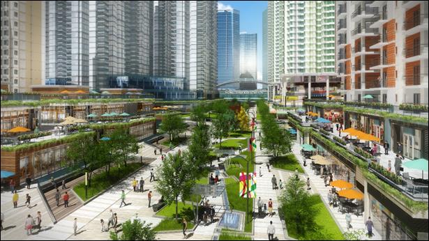
Conceptual diagram of pedestrianised shopping street which connects to
the proposed HSK Station
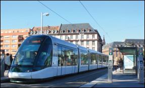

Environmentally-friendly modes of transport
·
Introduce
Integrated Green and Blue Network – A comprehensive open space network has
been planned through the Project area. Leisure and recreational spaces that
optimise the existing natural, cultural and landscape resources are introduced
to form an integrated green and blue network. In particular, the regenerated
river channels and high quality riverside promenades would form the spine of
the open spaces framework, and also operate as a continuous pedestrian walkway
to enhance connectivity of the entire Project area. It would link up several
important open spaces and recreational spaces within the Project area,
including the Regional Town Park at the centre of the Project area and the
Regional Plaza in front of the proposed HSK Station.
·
Adopt
Sensible Road Arrangement – The
re-arrangement of the road network within the Project area by replacement of
Tin Ying Road and downgrading of Hung Tin Road will reduce the existing road
traffic noise and minimise pollutants generated from road traffic. The
proposal for replacing
Tin Ying Road also provides an
opportunity to integrate a leisure riverside development
along the river channel and facilitate better connectivity between TSW New Town and the Project area.
|
|
|
Conceptual diagram of revitalised river
channel |
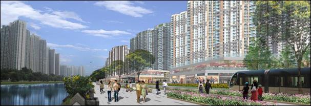
·
Promote Green Initiatives – The
Project provides an opportunity to showcase a range of green initiatives
adopted to create a green city. Major population, economic activities
and community facilities will be concentrated within walking distance of
railway and public transport nodes. Green mobility is promoted within the
Project area through the introduction of the GTC and a comprehensive pedestrian
walkways and cycle
tracks network. To
promote sustainable use of water, using reclaimed water and harvested rainwater
for non-potable purposes such as toilet flushing and irrigation within the
Project area would be explored.
Other green initiatives include the provision of a community green station for
environmental education and collection of recyclables from the local community
and promotion of energy efficient buildings and installations.
Sustainable drainage systems or facilities have also been
identified (e.g. rainwater harvesting, roadside bioretention swales, blue-green
infrastructure, flood retention facilities). The implementation of these measures
would reduce and attenuate stormwater flows, avoid/reduce flooding, improve
water quality of channels, and improve ecological value of channels.
·
Preserve
and Promote Cultural Heritage Resources – All Declared Monuments and Graded
Historic Buildings are well preserved and kept intact. In addition, the Project
provides an opportunity to promote the cultural heritage resources though the
provision of a cultural heritage trail. This trail is proposed to begin at the
existing TSW Station and proposed HSK Station and permeates through the Project
area along the existing open space and “A” zones to interlink the heritage
features at Ha Tsuen. The trail provides a safe and efficient amenity for
people to explore many of the culturally significant areas in the Project area
and is also intended to help promote these features and draw people to the
area.
·
Optimise Natural Resources –
The retention of the San Sang San Tsuen egretry in “Green Belt” (“GB”) that is
buffered by “Local Open Space” (“LO”), is an improvement upon its current
condition in a highly disturbed open storage area, as it increases protection
of the egretry. The “LO” also provides
an eco-corridor, covering the ardeid flight paths, and providing connectivity
to foraging habitats to the east. The Project will be a place for leisure
pursuits integrated with natural, cultural and landscape resources, which is
intended to foster health, wellness and human-nature integration. Natural
features in the surroundings of the Project area such as knolls, mountain
backdrop of Yuen Tau Shan and woodlands have been respected and taken into
account at the urban design of the Project area. Existing natural resources
within the area including the San Sang San Tsuen Egretry and mitigation ponds
under the DBL project
have also been preserved and incorporated into appropriate land use zones. In
addition to creating a place for restorative nature, the
Revised RODP also promotes connectivity through integrated open spaces and green
network. With respect to the rich natural resources in the Project area, an
eco-trail is proposed under the Revised RODP for public enjoyment. The
eco-trail will start at the proposed Regional Town Park, permeates through the existing
traditional villages of Ha Tsuen and links with the hiking trails at Yuen
Tau Shan, which leads to Ling To Monastery.
2.6
Formulation of the
Revised Recommended Outline Development Plan
2.6.1
The Revised RODP (Figure 2.2) has evolved from the Preliminary Outline
Development Plan (PODP), to the RODP, and then finally the Revised RODP, based
on the outcome and findings from the community engagement process and the
subsequent public views, the underlying planning principles, and technical
assessments. These are discussed in the following sections.
2.7
Public Views
2.7.1
To foster community support and general
consensus on the key issues, a continuous Community Engagement process
comprising a 3-stage Community Engagement exercise was undertaken.
· Stage 1 Community Engagement – First Round (commenced in November 2010): to present to various statutory and advisory organisations the key issues of the Project, including its vision, strategic role and planning principles.
· Stage 1 Community Engagement – Second Round (commenced in December 2011): to meet with the major stakeholders, discuss and exchange views with the public on the development of the Project.
· Stage 2 Community Engagement (commenced in July 2013): to consult the public on the PODP and to facilitate formulation of the RODP.
· Stage 3 Community Engagement (commenced in June 2015): to brief the public on how the Government had taken into consideration the comments received during Stage 2 Community Engagement in formulating the RODP and to obtain feedback to facilitate final refinement of the recommended development proposals and subsequent formulation of Revised RODP and proposals.
2.7.2 The Stage 1 Community Engagement – First Round was commenced in November 2010 by CEDD and PlanD before the commencement of this Assignment. In December 2011, the Stage 1 Community Engagement – Second Round was formally launched. The main purpose of the Stage 1 Community Engagement was to engage the community at the beginning of the Study process to help build the community visions for the Project. This facilitated the preparation of development concepts for further discussion in the community.
2.7.3 During the Community Engagement, the Study objectives and the existing context and key issues of the Project in terms of land use, transportation, infrastructure, cultural heritage and ecology were presented.
2.7.4 The comments received during the Stage 1 Community Engagement activities mainly focused on the strategic role and function of the Project, possible land use provision to provide land for the increasing population and job opportunities for local people, environmental protection and preservation, and the appropriate implementation mechanism as well as increasing public participation. The key environmental related comments received from the public during the Stage 1 Community Engagement are summarised in Table 2.4.
Table 2.4 Key Comments Related to Environment Received During Stage 1 Community Engagement
|
Key Issue |
Public Comment |
Action / Response |
|
Strategic Roles of the Project |
The Project should be developed as a second town
centre of Hong Kong or another Central Business District outside traditional
business districts. The development should make use of the geographical
location which is in proximity to two border crossing points to integrate
with the natural environment and making the Project as an example of
sustainable development. |
The proposed HSK Station would make use of the existing
and planned transport system to link with the Hong Kong International
Airport, the Northwest part and other regions of Hong Kong as well as
Shenzhen. This will also strengthen the strategic roles in development in the
region including Qianhai and the PRD. |
|
Open Storage and Port Back-up Uses |
To meet with the strategic, regional and local
needs, the brownfield operation sites should be consolidated and relocated to
a more remote area such as the periphery of the Project area so as to convert
land for development in particular for housing development. The consolidation
and relocation of these brownfield operations could enhance the compatibility
of the community within Project area. |
We propose to allocate the land in the northwest
part of the Project area as “Special Industry” for consolidating these
brownfield operations. The area is close to the KSWH, which can easily be
connected to Hong Kong International Airport and the Mainland. The associated
vehicles are not required to travel through the proposed residential areas of
the Project. This can minimise the environmental impacts and disruption to
residents in the Project area as well as maintaining the operation of the
business. |
|
Sustainable Development |
The Project should be developed following the
sustainability principles in planning for an environmentally-friendly,
people-oriented and balanced community and building a model region of quality
living environment and harmonious community. There were suggestions on building
height, development density, low carbon living, use of renewable energy,
waste management facilities, grey water re-use, landscape provision, etc.
Some suggested rehabilitation of the existing drainage channels to enhance
landscape and ecological values for a sustainable development. There were comments to preserve the existing
rural environ and sites with significant ecological values. Buffer zones
should be provided in order to minimise disturbance to the ecologically
sensitive habitats, such as egretry, fishponds and other wetland areas. In
addition, there were suggestions to preserve historic buildings, cultural
heritage and sites of archaeological interest and to develop tourist route
for introduction of the history of the region and the wall-village life in
the past. |
It is our mission to develop the Project into a
sustainable community. We have made reference to the records in the
Government for all Declared Monuments, graded historic buildings and sites of
archaeological interest within the Study Area. We have also reviewed previous
environmental study reports for other infrastructure projects and have
identified features with significant ecological values within and in the
vicinity of the Study Area. We will retain the cultural heritage sites and
“GB” as far as practicable and will minimise the impact to sites of
significant ecological values. We will also consider introducing energy saving
measures at different levels, and exploring ways to achieve energy-efficient
objectives, as well as promoting a low carbon economy, which is based on low
energy consumption and low pollution. |
|
In preparing the land use proposal for the
Project, efforts should be made to enhance social integration between the
existing villages and the new residential development so as to create a
harmonious community. |
When formulating the land use proposals, we have
retained all traditional and recognised villages within the “V” within the
Project area. We have made special efforts in integrating the existing
villages and the surrounding natural environment with the new developments so
as to retain the harmony within Project area. We have cautiously designed the
building height and its variation within Project area so that the new development
can better integrate with the existing low-rise villages and high-rise
high-density residential buildings in TSW New Town. |
|
|
There were suggestions to extend the railway
services to HSK, using environmentally-friendly transport means, improving
road networks and encouraging walking and cycling within HSK as well as
enhancing connection of HSK with Kowloon and Hong Kong Island. |
We make use of the existing WRL as backbone of
public transport for the Project area. Apart from the existing TSW Station,
we plan to construct the proposed HSK Station to the west to link up other
regions of Hong Kong. The existing LRT with three Light Rail stations, namely
Nai Wai, Chung Uk Tsuen and HSK that runs along Castle Peak will serve the
southern part of the Project area. We have also reserved land along main
roads within the Project area for the EFTS for feeder services in the form of
rail-based type or road-based type. We will provide cycle tracks along the roads
within the Project area to have better integration between the existing
villages and the proposed residential developments. The proposed cycle tracks
will also link with the existing system in TSW New Town to enable an easier
connection with TSW New Town and to promote an alternative means of transport
in the region. |
|
|
Apart from transport infrastructure some members
of the public suggested there should be improvement to sewerage provisions to
villages in HSK and existing drainage systems to avoid flooding due to
development. |
We will investigate the provision of the
infrastructure within Project area such as the improving the existing
sewerage and drainage systems so as to build a better environment. |
Stage 2 Community Engagement
2.7.5 Based on the public comments received during the Stage 1 Community Engagement, the PODP was formulated and put forward for public comments.
2.7.6 The main activities in Stage 2 Community Engagement for the PODP included:
· Consultation Digest – was sent by post and by free collection to residents within and in the vicinity of the Project area as well as relevant parties for informing the details of the PODP.
· Public Forum – was held at the Auditorium of Yuen Long Theatre where about 470 participants attended.
· Roving Exhibition – deployed exhibition panels and video on the PODP to invite the public to make comments on the plan.
· Study Website – updated the study website as a platform to disseminate information to and receive comments from the public during Stage 2 Community Engagement.
· Briefing sessions with statutory and advisory committees and local community representatives – including the Panel on Development of Legislative Council, Town Planning Board, Advisory Council on the Environment, Yuen Long and Tuen Mun District Councils, Heung Yee Kuk N.T., Ping Shan, Ha Tsuen and Tuen Mun Rural Committees.
· Consultation Meetings – were held with relevant stakeholders including professional bodies, green groups, affected villagers, local concern groups, brownfield operators, Hong Kong Logistic Council, Hong Kong Council for Testing and Certification, and local industry operators.
2.7.7 Both supporting and objecting views on the Project were received during the Stage 2 Community Engagement. Major environmental related comments are summarised in Table 2.5. Taking into account the comments received in Stage 2 Community Engagement, a review of the PODP was undertaken and some amendments were recommended to formulate the RODP.
Table 2.5 Key Comments Related to Environment Received During Stage 2 Community Engagement
|
Key Issue |
Public Comment |
Action / Response |
|
Reserving Land for Logistics and IT&T Development |
Supporting comments were received on the location
of the logistics quarter adjacent to the KSWH which could avoid additional
traffic flow generated in other areas of the Project. There were also
comments suggesting further increase of land reserved for logistics uses. However, there were comments pointing out that
HSK was not the best location for logistics facilities, which they should be
located in Lantau, near Hong Kong Zhuhai Macao Bridge and airport. |
Within the proposed “Logistics, Enterprise &
Technology Quarter” on the RODP, about 37 ha of land has been reserved for
logistics facilities, while the Government will continue to explore the feasibility
to earmark some of the land in other parts of the New Territories for
logistics developments as well. About 9 ha of land has also been reserved for
“OU (Enterprise
and Technology Park)” (“OU (E+TP)") and about 24 ha of land for
“OU(PBU+SWU)" to consolidate the existing brownfield operations. The proposed “Logistics, Enterprise and
Technology Quarter” is located near KSWH which would provide direct
connection through the transport corridor to the airport and the Mainland.
There is a primary distributor underneath KSWH and two interchange roads for
HGVs to access the KSWH directly without the need to penetrate the
residential areas to the east. The impacts of the operations from these
industries to the NDA residents would be kept to a minimum. |
|
Transport Infrastructure |
Many commenters opined that the existing
West Rail and Light Rail services were saturated, especially in the peak
hours in light of that a large amount of residents had to work cross
districts. Many comments pointed out
that most parts of the NDA were not served by public transport. There were
grave concerns on the increased population in the Project area without
provision of new public transport infrastructure which would further worsen
the situation. Those comments emphasised that the present public transport
facilities could not cope with the future population of the NDA. There were suggestions that the Project
should provide sufficient feeder services connecting to West Rail and Light
Rail stations. There were also comments suggesting building railway
connecting from Tuen Mun and Tsuen Wan, whilst others also suggested to
construct another West Rail station at TSW New Town. The frequency of the
West Rail and Light Rail services should need to be increased. |
Starting from 2016,
the number of train
compartments of the
WRL would
increase from 7 to 8, and the passenger capacity could increase by at least 14% upon completion of enhancement works. In view of the
proposed new development in the NDA, a new station at HSK has been proposed
to serve the future transport demands in the NDA. For long term planning (after year 2031),
the Government will timely bid for resources and commence studies for
improving the carrying capacity of the railways in NWNT beyond 2031. They
include studies on enhancing or improving the existing railway lines, or even
the feasibility of constructing new railways, in order to cope with the new
traffic demands. Within the Project area, there will
be a comprehensive transport network comprising a separate EFTS connecting to West Rail and Light Rail
stations, roads, pedestrian walkways and cycle tracks. |
|
Some people expressed concerns to the proposal to
remove Tin Ying Road. They said that
removal of Tin Ying Road would increase traffic demand on Ping Ha Road. They
were also concerned that the bus route running along Tin Ying Road for
connecting residents in northern part of TSW New Town with TSW Station would
likely be affected if Tin Ying Road was removed. On the other hand, some
commenters supported the deletion of Tin Ying Road on grounds that the
proposal could integrate future development of the Project area with TSW New
Town and eliminate the noise problems generated by the road. They commented
that the whole transport network of the Project area should be carefully
planned to deal with the impacts brought by the removal of Tin Ying Road,
with due consideration on the traffic situation in TSW New Town. There were
also comments expressing concerns over the noise impact brought by the major
roads in the Project area, for example KSWH and Castle Peak Road, and
requested Government to construct noise barriers along these major roads to
minimise the noise impact to neighbouring residents. |
A comprehensive road network is proposed in
the Project area through modification of the existing roads and provisions of
new roads. The proposed road network will thoroughly link up all the areas
within the Project as well as providing convenient linkages with nearby area
such as TSW New Town and the existing strategic highways. The proposal for replacement
of Tin Ying Road serves to provide a
leisure riverside development along the channel and facilitate better
connectivity between TSW New Town and the Project area. In connection with this proposal, there will be new roads proposed to
ensure that traffic connectivity is maintained. The existing Ping Ha Road
would be widened in order to cope with the increase in traffic demand due to
the removal of Tin Ying Road. Any
traffic re-arrangements including the removal of Tin Ying Road will only be
implemented upon completion of the replacement roads. The future arrangement of bus services will
be worked out and implemented by the bus operators based on the situation at
that time and in consultation with Government Departments and district
councils. The planned roads serving
the Project area would be designed and constructed in compliance with the
relevant statutory air quality and noise standards. |
|
|
Some comments suggested that a sustainable
transport strategy should be adopted in the Project, with comprehensive
public transport, cycle tracks and pedestrian walkways connecting different
land parcels in the Project area and the road network should not result in
separation of communities. Public also concerned about the provision of cycle
tracks, cycle parking and cycle and footbridge connections. Some comments
suggested widening of Kiu Hung Road and Lau Fau Shan Road. In general, people supported the idea of
EFTS within the Project area to cater for the increase in population and job
opportunities. The proposed EFTS should connect to West Rail and Light Rail
stations. Some people suggested extending the Light Rail to the Project area
while some people said that the Light Rail occupied large amount of land and
there were accidents occurred at road junctions due to interfaces between
Light Rail and road traffic. |
A designated GTC has been reserved in the RODP
running through the developments in the Project area and connecting to the
existing TSW Station, the proposed HSK Station and existing Light Rail
stations. This designated corridor will be running at grade but with grade
separated structures at intersecting points with vehicular roads. The GTC
will include a EFTS, pedestrian walkways and cycle tracks to provide feeder
services to connect the residential clusters with the major employment nodes,
railway stations and key community facilities. The GTC will provide rapid
intra-district transport system for the Project area. The type/mode of the
at-grade feeder system will be determined in a future study. Cycle tracks and pedestrian walkways are proposed
along the GTC for cyclists and pedestrians to enjoy the obstacle-free
movement within the Project area. The existing pedestrian walkways and cycle track network would also be
strengthened with introduction of new cycle tracks to form a complete
pedestrian and cycle track network within the Project area. |
|
|
Green Living Environment and Green Infrastructure |
The use of EFTS and others carbon reduction
strategies were generally supported by the public. Some suggested that
sufficient incentives to entice the participation from both the private
sector and the community at large should be provided for achieving the
objective of creating green living and working environment. Some commenters considered that the PODP did not
propose many environmental and sustainable elements and could not demonstrate
people-oriented vision. Some comments suggested upgrading the SW STW to secondary
treatment plant to improve the effluent quality. Some suggested that an
artificial lake should be proposed in the Project area to collect rainwater.
Some suggested that waste collection facilities should be introduced in the
Project area. |
A green city concept in the NDA will be promoted
by enhancing the connectivity, achieving low carbon emission and improving
the information communication technology. Apart from the provision of EFTS
and a comprehensive network of pedestrian walkways and cycle tracks as well
as other conventional greening, we will introduce other forms of green
initiatives including the possibility of using reclaimed water for toilet
flushing/irrigation, sustainable urban drainage system including flood
retention lake and regeneration of channels, community green station to
promote waste sorting and recycling, and use of different forms of renewable
energy for development and infrastructure, etc. To achieve the green city
concept, land has been reserved in the RODP for the provision of various
proposed green initiatives. |
|
There were comments related to regenerating
existing river channels which opined that the regenerated river channels not
only had the potential to create diversified habitats for wildlife, but also
improved the quality of life enjoyment that is vital to build up a harmonious
community. There were supportive comments on the proposed regeneration of
existing river channel, which was suggested to be further developed as a
water activity centre. |
The creation of a riverine promenade along the
regenerated channel is proposed. Pedestrian walkways, cycle tracks, EFTS and
street-level shops and restaurants are proposed along the promenade for
convenient access and enjoyment of the pleasant environment by the public. The
pedestrian walkways and cycle tracks will continue along other channels such
that people can travel through the Project area along these scenic routes. |
|
|
Ecology and Environmental Conservation |
While some
green groups agreed with the NDA development because most parts of the land
within Project area were already disturbed, they urged that areas generally
of ecological importance, such as the San Sang San Tsuen egretry, should be
conserved properly. There was comment on the preservation on the low-rise development
and the agricultural land near the egretry at San Sang San Tsuen. The flight
path to the east of Tin Sum Channel and HSK Channel should also be retained.
Green groups considered that the “GB” should cover a larger area and did not
agree to have public housing adjacent to the egretry to avoid disturbance to
the birds. They also requested the development not to cause impacts on the
flight path. There was also suggestion to rezone the egretry and its
surrounding areas as “CA” instead of “GB”. The green group also suggested
that studies should be conducted to provide information about the use of
egretry and the egrets’ feeding areas; assess the development impact to
breeding and roosting ardeids and carrying out flight-line surveys to
investigate if the development would intercept the flight lines. They
suggested that there should be more innovative planning in the aspects of
ecology, energy conservation and nature-human interface. Some comments
considered that the “GB” zones within the Project area are dispersed and
small. |
The egretry and vicinity areas will be protected
from direct impacts through its inclusion in “GB” and “A” zones on the RODP.
In addition, the “Open Space” zone corridor to the east of the “GB” will help
to maintain open areas for ardeid flight paths. During the construction
phase, disturbance impacts can be mitigated by undertaking any major
construction works outside of the breeding season of the ardeids (i.e. March
to August), and by providing screening to minimise disturbance (e.g. hoarding
set-up along the boundary of the works areas to shield the egretry from
disturbance). Mitigation ponds (under the DBL project)
associated with the KSWH will also be retained in-situ under the “GB” zone.
The provision of an eco-corridor between the “GB” areas will help to
consolidate and connect the habitats of these areas. Habitats will be created
within the corridor which will help to maintain and improve the ecological
value of the area. |
|
Green groups also raised concern on the
displacement and relocation of brownfield operation sites, worried that the
displaced operations would be relocated to other areas outside the Project
area and would have negative impacts to the environment. They urged
Government to formulate a long-term policy on the management of the
brownfield operation sites, such as providing an area to centralise the
processing of the open storage sites and have a holistic view to formulate a
comprehensive plan regarding the developments and their impacts in and around
the Deep Bay so as to protect the integrity of the ecosystem. |
At present, the proliferation of brownfield
operations in Project area has created considerable environmental, traffic,
visual, flooding and other problems. One of the objectives of developing the NDA
is to convert these brownfield sites to more optimal uses and improve the
overall environment of the area. To avoid their further proliferation,
suitable land has been reserved as “OU(PBU+SWU)” for consolidation of these
existing operations in an efficient manner. |
|
|
Integration with Retained Villages |
Some village representatives concerned about the
new roads proposed for the Project area which would surround the retained
villages. They also worried about the building 40 storey residential
buildings which would create wall effect and will affect the environment and
drainage of existing villages. They requested that the “Fung Shui” lanes be
retained. Some village representatives suggested that the Government to
improve the sewerage disposal, drainage and emergency access problems in
conjunction with the development so as to improve the living environment.
They also commented that existing village parking should be retained. |
Sufficient buffer has been introduced on the RODP
as “A” and Non-building Area (NBA) between the existing “V” and new high-rise
developments. A 5 m NBA is also proposed for the private residential
developments facing Lo Uk Tsuen, Ha Tsuen and San Uk Tsuen to increase the
separation of tall buildings from the “V”. We have also conducted air
ventilation assessment of the proposed buildings in the Project area to avoid
creating “wall-effect”. Existing Fung Shui Lanes are retained on RODP. |
|
Many villages expressed concern on the drainage
issues in the Project area, since the existing villages are lying in the low
areas, villagers worried that with the construction of development beside the
villages, their area would be exposed to flooding risk and urged Government
to comprehensively study the drainage and in the Project area. |
Drainage impact assessment has been conducted and
proposals have been developed to improve the drainage system within the
Project area to avoid flooding due to the development. Flood protection
measures in the form of flood retention lake and underground flood retention
facilities for retaining the storm water during storm surge will also be
proposed to low-lying villages to alleviate the flooding situation in low
lying areas. |
|
|
Cultural Heritage |
Supporting
comments were received on the preservation and linking up of different
heritage resources within the Project area by heritage trail. However, since
the heritage resources are scattered over the Project area and some were not
accessible within walking distance, commenters suggested more details be
given on how the different heritage resources could be connected by the
proposed heritage trail and enhance tourism in the Project area. Some public
opined that apart from the natural environment and heritage, old villages
within the Project area could be redeveloped to become hostels, and
constructed museum of local village for tourists to experience the
traditional village lifestyle. There were also comments suggesting HSK as a
potential area for ecotourism, which could link up with the Hong Kong Wetland
Park at TSW New Town. Comment also suggested that the heritage trail could
possibly be linked up and extended to Lau Fau Shan. Apart from those historic
buildings and heritages, comments were also received suggesting the local
villages and factories within Tan Kwai Tsuen and Wo Ping San Tsuen were rich
in history and should also be retained. |
One of the key principles of planning the NDA is
to seek balance between development and heritage conservation. The network of cultural heritage trails
proposed under the PODP has been reviewed, taking into account the public
comments that the built heritages are generally scattered over the Project
area not accessible within walking distance and difficult to locate. The
proposed cultural heritage trails under the RODP focus in the Ha Tsuen to allow
public to appreciate the precious heritage resources by walking. The trail is
proposed to start at the TSW Station, which will also link with the existing
Ping Shan heritage trail to promote cultural tourism of the Yuen Long
district. The proposed trail will pass through two Declared Monuments, Tang
Ancestral Hall and Yeung Hau Temple, and three graded historic buildings, Shi
Wan Study Hall, Kwan Tai Temple and Gate Tower of Ha Tsuen, Ha Tsuen Shi. While many of the historic buildings are located within
“V” zones and are proposed to be preserved in-situ, no Declared Monuments or
graded historic buildings will be affected by the Project proposals. With respect to the rich natural resources in the
Project area, an Eco-trail is proposed which will start at the proposed
Regional Town Park, linking with the hiking trails at Yuen Tau Shan, which
leads to Ling To Monetary. |
Stage 3 Community Engagement
2.7.8 Based on the public comments received during the Stage 2 Community Engagement, the RODP was formulated and put forward for public comment during the 3-month Stage 3 Community Engagement, which was completed in September 2015.
2.7.9 The main activities in Stage 3 Community Engagement for the RODP included:
· Consultation Digest – was sent by post and by free collection to residents within and in the vicinity of the NDA as well as relevant parties for informing the details of the RODP.
· Public Forum – was held at Shung Tak Catholic English College where about 550 participants attended.
· Roving Exhibition – deployed exhibition panels and video on the RODP to invite the public to make comments on the plan.
· Study Website – updated the study website as a platform to disseminate information to and receive comments from the public during Stage 3 Community Engagement.
· Briefing sessions with statutory and advisory committees and local community representatives – including the Panel on Development of Legislative Council, Town Planning Board, Hong Kong Housing Authority, Advisory Council on the Environment, Yuen Long and Tuen Mun District Councils, Heung Yee Kuk N.T., Ping Shan, Ha Tsuen and Tuen Mun Rural Committees.
· Consultation Meetings – meetings were held with relevant stakeholders including professional bodies, green groups, affected villagers, local concern groups, brownfield operators, Hong Kong Logistic Council, Hong Kong Council for Testing and Certification, local industry operators etc.
2.7.10 Both supporting and objecting views on the Project were received during the Stage 3 Community Engagement. Major environmental related comments are summarised in Table 2.6.
Table 2.6 Key Comments Related to Environment Received During Stage 3 Community Engagement
|
Key Issue |
Public Comment |
Action / Response |
|
Need and Positioning of the Project |
Some supportive comments pointed out that given the strategic
location, the Project could complement the Qianhai’s development, bringing
out Hong Kong’s advantages in producer services and creating synergy with the
enterprises in Qianhai. Not only would it foster economic interaction with
the Mainland, but also economic sustainability of Hong Kong. Some comments raise that Hong Kong should
provide more land for economic development to seize opportunity brought by
the “One Belt, One Road” initiatives of Mainland China. On the other hand,
some commenters were of the view that the NDA should cater for the needs of
Hong Kong people. Some comments stated that the Project was not planned with sufficient
civic facilities, and its positioning as the “Regional Economic and Civic
Hub” for the NWNT could hardly be achieved. |
The Project is positioned to serve as a “Regional Economic and Civic
Hub” for the NWNT. It will be
developed as a new generation new town for supporting the social and economic
development of Hong Kong, providing a desirable place to live, work, learn
and play for the Hong Kong people. The wide range of land uses will help the
Project to be developed as a “Regional Economic and Civic Hub”, and create
new employment opportunities of different types and nature for the residents
in HSK as well as the neighbouring areas. In planning the G/IC facilities for the Project area, we have reviewed
the current provisions and constraints, as well as followed the “Hong Kong
Planning Standards and Guidelines” and advices from various Government
departments. We have also taken into consideration the needs of surrounding
area. A number of civic and G/IC facilities have been planned, which will
facilitate the Project to become the “Regional Economic and Civic Hub” of
NWNT. |
|
There were comments suggesting more commercial and G/IC facilities in
the northern part of the Project area to serve TSW New Town and the
surrounding villages. Villagers of Shek Po Tsuen and Hung Uk Tsuen expressed objections
towards the construction of a hospital and RCP near the existing village,
opined that these facilities would negatively affect the living environment
and “Fung Shui”. They asked the Government to relocate these facilities
elsewhere. Similarly, there were comments opposing the proposed RCP opposite
to Hung Fuk Estate for its potential adverse impact on the health of the nearby residents
in Hung Fuk Estate. |
During CE3, we have received public comments pointing out the shortage
of community facilities in TSW New Town. In this regard, we have adjusted
some of the land uses in the northern part of the Project area on the Revised
RODP to form a “Local Service Core”. A site abutting Tin Wah
Road and Ping Ha Road originally zoned as “LO” has been rezoned to “G” for
provision of various facilities including community hall, clinic, RCP and
other social facilities to serve residents living in the northern part of the
Project area and TSW New Town and to strengthen the connection between TSW New Town and Project
area. Furthermore, a site originally planned for an open-air PTI has been
rezoned to “OU” annotated “Commercial cum PTI and Public Carpark” to provide
more commercial and community facilities in the northern part of the Project
area and to better utilise land resources. Regarding the proposed hospital, the site area has been reduced in
association with the proposed expansion plan for the TSW hospital, and the southwestern
part of the original hospital site is rezoned for “E” and “G” uses.
Additional “A” and “LO” are planned along Hung Tin Road and west of Hung Uk
Tsuen and Kiu Tau Wai in order to increase the buffer distance between the
villages and the hospital. Besides, a new local road is introduced to the
west of Kiu Tau Wai and Hung Uk Tsuen so as to further separate the hospital
from the villages as well as to provide additional vehicular access. The RCPs proposed in the Project area will adopt the latest enclosed
design, which will meet the relevant hygiene standards. The concerned RCP
near Hung Fuk Estate is separated from the housing estate by Hung Yuen Road.
As most refuse collection vehicles have now adopted fully enclosed design,
the nuisance caused by the operation of the RCP should be minimised.
Regarding the proposed RCP near Shek Po Tsuen, we have re-arranged the land
use of the site as well as realigned the proposed local road nearby. The
concerned RCP will be moved to the northern part of the Project area, and its
original location will be reserved for educational use. An additional “A” is
added along the proposed local road to serve as a buffer between the new
developments and Shek Po Tsuen. |
|
|
Developing Brownfield Sites |
The public generally supported utilising brownfield sites for
development. However, some green groups expressed concern that some
brownfield operators will relocate to other greenfield sites in adjacent
areas such as Lau Fau Shan, which will damage the environment and ecology of
those areas. |
To avoid further proliferation of brownfield developments, the
clearance for brownfield operators will be carried out in phases during the
implementation of Project. About 24 ha
of land has been reserved as “OU(PBU+SWU)”, including the possible
multi-storey buildings for accommodating some of the affected brownfield
operations in a land-efficient manner. The Government will actively explore
the feasibility of accommodating some of the affected brownfield operations
in multi-storey buildings. |
|
Some residents expressed concern over the traffic impact brought by
the population growth in the Project area while other opined that the current
WRL was reaching its capacity, and the proposed HSK Station would increase
the loading on the WRL. There were doubts over the feasibility of the proposed increase of the
train frequency per hour and number of train compartment could effectively
alleviate the current overcrowding situation of the WRL. They also expressed
that the increase in train frequency and the number of train compartments
would not help improve the problem of overcrowding of the WRL. |
To alleviate the existing crowdedness of the WRL, the train of the WRL
has been gradually increased from 7-car to 8-car starting from January
2016.The passenger carrying capacity will be increased by at least 14% upon
upgrading of all WRL trains to 8-car. Considering the infrastructure along
the “East West Corridor”, including fire safety requirements in tunnel
sections and the platform length etc., it is expected that the “East West
Corridor” (including the current WRL) can reach a highest operational
capacity of 28 trains per hour, with 8 cars on each train. According to this
estimation, the train capacity will increase by 60% over the current 7-car
trains operating at an hourly frequency of about 20. Even though the Project will bring about increase in population and
traffic demand, with the provision of related road infrastructure and
transportation facilities, a significant increase in the operating capacity
of the WRL, and the large amount of employment opportunities within the
Project area so that many local residents and those from the New Territories
could work in the Project area and no need to commute to the urban areas
(i.e. Hong Kong Island and Kowloon) for work, it is estimated that the WRL
Service would be able to cope with the traffic requirements in the Project
area. |
|
|
There were a number of comments made in light of the removal of Tin
Ying Road, as this road was vital for the existing traffic. Ha Tsuen Rural Committee expressed concern about the transport
infrastructure in the Project area, suggested retaining Tin Ying Road, and
widening of Lau Fau Shan Road. Some hoped for the implementation of a new
road connecting the NWNT and the urban areas, and suggested the transport
network of the Project area should be connected with the existing Light Rail
system. Some comments stated that TSW New Town had been experiencing
serious traffic problems during peak hours and hoped that the Government
could consider providing other transport infrastructures connecting TSW New Town and urban areas. A
comment has been made pointing out the junction congestion problem between
Tin Yiu Road and Ping Ha Road, and hoped that the Project would bring about
improvements to this problem. A concern was expressed over the connections and transport
infrastructure between TSW New Town and the Project area, stating that there
was no indication on the RODP about the connection of the two regions. It is
suggested that the Government should plan for appropriate road networks to
improve the traffic situation in the area and strengthen the connectivity
between the Project area and TSW New Town. Besides, some opinions suggested
the Government should reduce the reliance on Light Rail as the transport in
NWNT, and to strengthen the connectivity between TSW New Town and Project area. A comment suggested converting the power lines from overhead to
underground, and to elevate part of the at-grade Light Rail Line along Castle
Peak Road to facilitate its widening proposal. |
To cope with the future development and to improve integration of the
surrounding areas including TSW New Town with the Project area, there will be
reorganisation of the local transportation network to increase its efficiency
and capacity. This would include the construction of new roads, the
improvement of existing roads and addition of cycle and footbridges across
the TSW Main Channel. Tin Ying Road is built next to the TSW Main Channel close to the
neighbouring residential developments in TSW New Town, leading to a certain
degree of noise and air pollution. It also separates the Project area from
the TSW areas. Under the proposed traffic network, Tin Ying Road will be
replaced while its function would be supplemented by the widening of Ping Ha
Road and by other newly planned roads. This will release land resources for
more efficient land uses, including the provision of a riverside promenade,
and to introduce an EFTS near TSW New Town. The noise and air pollution
impact to neighbouring residents will also be reduced. Regarding the suggestion to widen Lau Fau Shan Road, after the
existing brownfield operations have been consolidated, the land will be used
for residential development and the current Lau Fau Shan Road could cope with
the future demands. Yet, an additional local road extended to Deep Bay Road
has been proposed in the Revised RODP to further enhance the connectivity in
the Lau Fau Shan area. In response to currently serious traffic congestion problem in TSW
during rush hours, we have proposed the construction of a new road at Hung Uk
Tsuen and west of Kiu Tau Wai connecting Hung Tin Road on the Revised RODP,
to provide easy and direct access to the TSW Station and neighbouring
villages, to alleviate traffic problems surrounding Ping Ha Road. This road
will also act as an alternate path towards the proposed HSK hospital and
provide an additional connection to the nearby villages. Regarding the suggestion to convert the high voltage power lines
underground and partially elevate sections of the Light Rail, there are many
technical difficulties thus appropriate planning arrangements have to be made
to ensure that the current high voltage power lines would not be affected by
the Project. There are also many implementation issues about elevating the
Light Rail as various sections of Light Rail line are overlapping with KSWH
and Hung Tin Road sections, thus this would require associated changes in
height, and the whole section would be higher than normal elevated railways. |
|
|
There were comments regarding the alignment of the GTC which suggested
improving the alignment for the convenience of the villagers. |
Land has been reserved for GTC on the Revised RODP, to provide a
transit through the entire proposed development area, connecting the existing
TSW Station, proposed HSK Station, and the current Light Rail. The proposed
GTC will be constructed at grade and will be separated from traffic roads by
varying levels at different sections. The GTC includes an EFTS, pedestrian
walkways and cycle tracks, providing an efficient feeder service connecting
residential areas to other major facilities. In response to comments
regarding the alignment of the EFTS, we have already adjusted the EFTS with
some sections closer to existing villages for ease of access of its
residents. |
|
|
Some green groups stated that the egretry was surrounded by logistics
facilities and Enterprise and Technology Park on the RODP, and although there
were buffer areas separating the egretry from its surroundings, it was still
considered insufficient. They suggested that the surrounding area next to the
egretry should be rezoned as “GB”, and connected to the two "GB"
zones next to KSWH, or at least further expanding the "LO" adjacent
to the egretry. They further recommended adopting stepping building height
design for the adjacent logistics facilities and Enterprise and Technology
Park, and to provide additional buffer areas at the periphery of these sites
so as to minimise impact to the egretry. |
To offer protection to the egretry in San Sang San Tsuen egretry, the
adjacent land uses have been re-planned in the Revised RODP, including
relocation of the proposed ESS and enlargement of the “LO” sites adjacent to
the egretry. The “LO” adjacent to the egretry is proposed for passive uses
only to maintain spacious areas for protection of the flight paths. |
|
|
Some green groups welcomed the ideas of
revitalisation of TSW Main Channel, but hoped to see more detailed proposals
on how the ecology of the river channel could be improved. Members of the Advisory Council on the Environment and some villagers
of Tin Sum Tsuen suggested a continuous riverside promenade at Tin Sum Tsuen. A green group stated that there were less “GB” in the RODP as compared
to the current OZP and that the Government had not provided any
justifications. |
We fully agree that the existing river channels should not only be
regenerated and beautified, they should also be used for the enjoyment of the
public. The proposed riverside promenade along the regenerated river channel
will include pedestrian walkway, cycle track, EFTS, shopping streets and
restaurants for convenient access and enjoyment by the public. The pedestrian
walkways and cycle tracks will continue along other river channels such that
people can travel through the Project area along these scenic routes. In response to the comments from villagers
of Tin Sum Tsuen and the Advisory Council on the
Environment, we have examined the alignment of the
revitalised river channel and proposed to realign the section near Tin Sum
Tsuen with corresponding adjustments to the “V” boundary of Tin Sum Tsuen and
expansion of the adjacent “LO” in order to provide a continuous network in
north-south direction from TSW New Town to the south of the Project area. One of the planning principles of the Project is to strengthen and
avoid impacts on “GB” areas, and integrate them with the planned open space
network. |
|
|
Integration with Retained Villages |
Ha Tsuen Rural Committee expressed concern that the new developments
surrounding the existing villages will affect their living environment, “Fung
Shui” and traffic conditions. They proposed to install noise barriers to
minimise the potential noise impact and asked for better protection of the
Fung Shui Lane. Ping Shan Rural Committee expressed concerns on the proposed high
density commercial and residential developments near Hung Uk Tsuen and Kiu
Tau Wai. Since there are already a number of high-rise buildings nearby, they
worried that the development would adversely affect the village environment
and layout. They hoped that the Government would re-plan the area to maintain
the existing condition, and reserve sufficient buffer to avoid affecting the
village environment. A member of the Advisory Council on the Environment worried about the
visual impact on the clusters of existing villages which would be encircled
by high-rise residential blocks. He suggested that sufficient buffer distance
should be considered. The Hong Kong Institution of Engineers stated that the Government had
not proposed any measures to integrate these villages with the proposed
developments. They urged the Government to propose measures to effectively
connect the existing villages and the Project area, such as planning of cycle
tracks. |
We have re-arranged some of the land uses near existing villages with
additional “A” to serve as buffers from the adjacent uses, near San Lee Uk
Tsuen, Shek Po Tsuen, Kiu Tau Wai and Hung Uk Tsuen in the Revised RODP. A strip of 6 m NBA has also been added to
the proposed “C&R” zone to the north of Kiu Tau Wai to make sure there
would be sufficient buffer and to minimise impact on the nearby
residents. A 5 m set back requirement from Road D2 has already been introduced on
the RODP to increase the separation of the new residential towers from the
existing villages and “A” zone have been incorporated along Road D2 as buffer
areas. To further address the public
and Advisory Council on the Environment concerns, we have rearranged land use
and spatial layout of the developments along the TSW Main Channel in the
Revised RODP, with incorporation of additional breezeways and open spaces to
enhance air ventilation performance. We have retained the current Fung Shui Lanes in the area. The “LO”
planned in front of the Declared Monument of Tang’s Ancestral Hall is further
expanded to further protect the Fung Shui Lanes from being blocked, and also
to provide more public spaces to allow festive and cultural activities to
take place. Furthermore, to enhance integration between the Project area and
existing villages and to promote walking, we propose an additional 10 m
pedestrian street at the northern part of the Project area, such that
villagers of Ha Tsuen could easily access the commercial and community
facilities located in the area |
|
Cultural Heritage |
Heung Yee Kuk N.T. stated that village traditions and cultural
heritage must be preserved. A Village Representative of Ha Tsuen Rural
Committee said the planning of the Project should take into account the Fung
Shui Lanes of Ha Tsuen, and must respect the tradition and history of the
villages. There has been proposals to link up various cultural heritage in the
villages through a historical and heritage trail and shopping streets to
promote rural-urban integration. There were comments requesting the Government to preserve heritage
items, including historic buildings with distinguished features and cultural
heritage within villages. Some villagers stated that there were quite a
number of old houses within the affected villages with over a hundred years
of history, thus they wished the Government would preserve these buildings. |
The Project would not affect any Declared Monuments or graded historic
buildings. The proposed heritage trail in the Revised RODP which is
concentrated in Ha Tsuen will allow the public to appreciate the valuable cultural
relics by walking. There are also other historic buildings and culturally
significant areas scattered in the Project area. Visitors could make use of
the comprehensive pedestrian walkway and cycle track network to travel around
the Project area and visit these attractions. We have retained the current Fung Shui Lanes in the area. The “LO”
planned in front of the Declared Monument of Tang’s Ancestral Hall is further
expanded to further protect the Fung Shui Lanes from being blocked, and also
to provide more public spaces to allow festive and cultural activities to
take place. As regard to the ancestral houses raised by a villager, according to
the built heritage assessment, the concerned buildings are nil grade built
heritage located in Tin Sum San Tsuen which were assessed to possess no
cultural significance and are commonly found in the New Territories.
Furthermore, as the buildings are situated at a central location of the
Project area, it is inevitable that the buildings will be affected by the Project. |
|
Urban Design and Development Intensity |
There were comments considering that the development density near the
TSW Main Channel was too high and raised concerns on the air ventilation
impact on existing villages. It was
suggested to lower the relevant development density and provide additional
breezeways to improve air ventilation in the area. |
The plot ratios of 5 to 5.5 and building height of 28 to 35 storeys
for the proposed residential developments along the TSW Main Channel are
generally lower than those of the existing residential developments in TSW
New Town on the other side of the channel.
They are separated from the TSW New Town by the approximate 135 m wide
channel cum riverside promenade. On the western side of the residential
cluster, a 5 m set back requirement from Road D2 has already been introduced
on the RODP to increase the separation of the new residential towers from the
existing villages and additional “A” have been incorporated as buffer areas.
To further address the public and Advisory Council on the Environment’s
concerns, we have arranged land use and spatial layout of the developments
along the TSW Main Channel in the Revised RODP, with incorporation of
breezeways and open spaces to enhance air ventilation performance. |
2.8
Planning Principles
2.8.1 Taking into account the positioning of the Project and public views received during the Community Engagement exercises, the following planning principles were formulated for planning and designing the Project.
Promote
Sustainable and Balanced Development
2.8.2 The planning and design of the Project adopts a sustainable development approach, balancing housing, employment, community and conservation needs, and encompassing economic, social and environmental considerations. Various urban design and greening features have been incorporated in the layout to achieve a quality living environment. High priority has been accorded to “sustainable design” and “social consideration”.
Reinforce Economic Development
2.8.3 Given its strategic location on major freight and passenger routes in the territory and between Hong Kong and Shenzhen, land should be reserved to accommodate diversified economic activities ranging from commercial uses including offices, retail and hotels to special industries including logistics as well as producer services. The development of these economic activities echoes the Government’s devotion to strengthen economic co-operation with the Mainland, reinforce the development of logistics industry to seize the opportunities brought by the growth of trade in the Mainland and Asia, and foster the development of innovation and technology as promoted in the 2015 Policy Address. Various types of economic activities could also generate employment opportunities that are accessible to a variety of skill sets. This could also help balance the territorial spatial distribution of jobs and address the problem of over concentration of employment in the urban area.
Foster People-Oriented Communities
2.8.4 To create a balanced community, a suitable mix of housing land would be introduced to allow for a wide range of housing choices for different needs and levels of affordability. Despite the dominance of public housing in nearby TSW New Town and the perceived socio-economic impacts arising from over-concentration of public housing, the Project will contribute in meeting the territorial demand for public housing and redressing the imbalanced housing mix of the TSW New Town.
2.8.5 Sufficient land should also be reserved for local supporting services and “G/IC” facilities within close proximity to residential developments. In planning for the supporting facilities, the requirements from the surrounding existing communities would also be taken into consideration. Activity nodes and open space could be introduced within residential areas to encourage social interaction.
Integrate Existing and New Communities
2.8.6 The new development will need to integrate efficiently with existing developments. Given that the Project is characterised with traditional and non-recognised villages, low and medium-rise residential developments, industrial developments and the provision of “PBU+OS”, a rational distribution of building massing that relates to its surrounding context will need to be realised. Building massing will need to be carefully designed so as not to create excessive visual impact to adjacent development. A descending building height profile will need to be enshrined in the development, with lower heights orientated towards existing villages and low rise development. The future arrangement and layout of buildings will also need to take account of the prevailing situation in TSW New Town and avoid creating a monotonous ‘wall effect’ development that limits visual permeability.
2.8.7 As there are a number of traditional villages within the Project area, disturbance of villages should be avoided in formulating the development proposals. Future development should be introduced in such a way that adverse impacts upon existing communities should be avoided. Ensuring the compatibility of future land uses with existing communities should be a fundamental consideration when planning the layout of the Project.
2.8.8 To ensure good integration between new developments and existing villages and residential developments in and around the Project area, a comprehensive pedestrian walkways and cycle tracks network connecting the existing communities with the newly proposed major activity nodes should be planned. This could also promote the shared use of community, recreational and commercial facilities, and enhance employment opportunities within the district.
Respect and Optimise the Use of Valuable Cultural and Natural Resources
2.8.9 The Project and the surrounding areas boasts significant cultural heritage as well as natural and landscape features that should be conserved and enhanced where possible.
2.8.10 In terms of cultural heritage, a number of Declared Monuments, graded historic buildings and sites of archaeological interest exist throughout the Project area, and must be given due consideration. It is important that mitigation measures to minimise potential adverse impacts arising from the development are undertaken. With regards to sites of archaeological interest, should disturbance to these sites be unavoidable, it is envisaged that proper recording of the archaeology of the site would be carried out in order to preserve their importance by record. Where possible, these resources should become an inherent part of the development to affirm the community’s identity within the Project. However, it is worth noting that the majority of these heritage structures are within the “V” zone which will be retained in the development proposal.
2.8.11 The Project area supports a number of natural and landscape features which could augment the environs and impression of the area when utilised appropriately. There are a number of ecological and natural features that would also need to be preserved. These include mitigation ponds (under the DBL project), woodlands, conservation areas and an egretry. The intention will be to maintain these natural features and where possible, integrate them with the development of the Project. As such, the conservation of these features can serve to augment the overall appearance and character of the area, provide additional appreciative recreational areas and will serve as an important natural asset for the Project area. There are a number of drainage channels/nullahs throughout the Project area and its surroundings that could be enhanced. For example the drainage channel separating TSW New Town and Project area, has the potential to be transformed into a vibrant open space. This area is currently utilised by members of the community for recreational pursuits such as walking and running. It is important to revitalise these landscape features, which could help to engender a positive identity for the community. These landscape features could be supplemented with appropriate soft and hard landscape treatments and transformed into useable public spaces. The greening of the environs of the drainage channels could also be further extended into a green network that could connect with existing and proposed open space in the Project and its environs. This green network could also be further strengthened in form of providing structural street planting, amenity planting and pocket parks where appropriate. This will not only foster a green living and pedestrian environment but also provide a great degree of visual relief to ameliorate the potential visual impacts arising from the future development.
Optimise the Use of Valuable Land Resource
2.8.12 Due to the ineffective and extensive use of valuable land resource and haphazard proliferation of brownfield operations blighting the landscape and resulting in adverse environmental and visual impacts to residents in the Project and surrounding areas, it is intended to consolidate these uses in a more efficient manner to unleash the valuable land resource and optimise the development potential of land for housing, economic and social developments. To this effect, land has been reserved in the Project area for “PBU+SWU” to accommodate of some of the affected businesses in multi-storey buildings.
Utilise Advance Infrastructure to Promote a Smart and Green Living and Working Environment
2.8.13 There is a growing interest in pursuing a quality, smart and green living and working environment for inhabitants and workers. Quality, smart and green living and working environment could be created by adopting a Transit Oriented Development (TOD) pattern and quality urban design, and promoting environmentally friendly transport services, comprehensive pedestrian walkways and cycling networks, efficient waste and water management, energy efficiency, ICT platform and other green initiatives.
2.8.14 To reduce road transport and thus reduce carbon emission, public transport and other environmentally friendly modes of transport are encouraged in the Project. The importance of integrating land use and transport facilities to ensure that one can complement the other is seen as an important consideration for development of the Project. To this end, there will be a priority to encourage TOD. TOD promotes mixed-use development to be typically located within a 500 m radius of a transit station. Development is generally concentrated near public transport nodes to make transportation more conveniently located for people. This type of development promotes the use of public transport and increases accessibility to public transit. Generally, transit stations are centres of various activities with the highest density of development located in closest proximity to these stations, with development density reducing the further away it gets. Provision of environmentally friendly transport modes to connect major residential areas, employment nodes and railway stations within the Project area could further enhance the use of rail transport and therefore should be explored.
2.8.15 Given the identified benefits associated with non-emission modes of conveyance (walking and cycling) including, less noise and air pollution and improvements to people’s health, a comprehensive pedestrian walkways and cycle tracks network should be provided in the Project. To encourage people to make trips by means of walking or cycling, it will be important to create an urban environment that is conducive to these activities. Greater consideration for pedestrians and cyclists can further facilitate the transition from cars to people traffic. This can be achieved in the Project by means of creating attractive streetscapes with roadside plantings to provide amenity, shade and providing safe and convenient at-grade crossings to limit dangers to pedestrians and cyclists. As such, pedestrians and cyclists should be given priority in the design of the Project.
2.8.16 To achieve a quality living and working environment, existing landscape resources such as channels and green mountain backdrops should be capitalised to create a townscape character. Other green initiatives such as sustainable waste and water management, DCS, use of renewable energy, energy efficient buildings and environmentally friendly technologies should also be promoted and adopted in the development proposals for the Project.
Integrate with Tuen Mun, Tin Shui Wai and Yuen Long New Towns
2.8.17 In planning for the transport connections, housing mix, “G/IC” facilities and job opportunities of the Project area, the needs and requirements from the surrounding developments including the Tuen Mun, TSW and Yuen Long as well as the proposed Yuen Long South development should be taken into account. Opportunity exists for the Project to enhance integration with the nearby new towns and developments, with the possibility of sharing infrastructure, resources and services. This is particularly true for the case of TSW New Town.
2.8.18 It is likely that improved integration between the Project area and TSW New Town will result in a number of benefits for the TSW New Town, such as providing access to new social and community facilities in the Project area. In addition to this, the introduction of new economic activity in the Project will introduce greater choices of employment opportunities and retail facilities to TSW New Town. Enhancing integration will also serve to introduce a greater balance to the community profile currently experienced in TSW New Town.
2.8.19 Integration between these two areas can be further augmented by means of walking and cycling. Whilst connectivity to and from TSW New Town and the Project area is available via car, bus, mini-bus and rail, limited access is available to and from these areas via walking or cycling. To enhance connectivity between the two areas, a comprehensive cycling and pedestrian walkway network is proposed in the development proposals.
2.9
Major Amendments from RODP to Revised RODP
2.9.1
Taking account of the public views, findings of
various technical assessments, and the planning principles, some amendments to
the land uses/layout in the Project area have been made to the RODP. The
following major changes have been reflected on the Revised RODP adopted in
undertaking the various assessments.
· Strengthening of the HSK Regional Economic and Civic Hub: In view of the public comments on further capitalising the strategic location of the proposed HSK Station, areas around the station have been restructured to create a more vibrant town centre. In response to comments requesting for more civic elements, the “G” site near the proposed HSK Station has also been enlarged to accommodate a performance venue to cater for such a need in the long run, in addition to the planned Government offices, community hall, magistrates’ court, post office and delivery office as proposed under the Revised RODP. A site near the KSWH is also rezoned to “G” for the provision of youth facilities.
· Providing More Commercial and Community Facilities in the Northern Part of the Project Area: In response to public comments for more commercial and community facilities in the northern Project area, a site near Sha Kong Wai originally planned for an open-air PTI is now rezoned to “OU(Commercial cum PTI and Public Carpark)” to better utilise land resources and provide more commercial facilities. A “G/IC” complex is also proposed at the northern part of the Project for a clinic, community hall, RCP and other social facilities to serve the Project area as well as the TSW New Town neighbourhood. To address the concern about the possible traffic congestion along Lau Fau Shan Road, a local road is proposed under the Revised RODP which will provide an alternative northwest to southeast connection, between Road D1 and Deep Bay Road.
· Improving Hung Uk Tsuen / Kiu Tai Wai Area: A new local road is proposed to the west of Kiu Tau Wai and Hung Uk Tsuen to link up Ping Ha Road with Hung Tin Road. This road would provide more convenient and direct access for the villages and ease the traffic at Ping Ha Road in the vicinity of TSW Station. To further address villagers’ concerns that the proposed hospital is too close to their villages, additional “A” strips and a “LO” are designated along the western boundary of Hung Uk Tsuen and Kiu Tau Wai to serve as additional buffers. As for villagers’ concerns on the proposed “OU(Commercial and Residential)” zone at Kiu Tau Wai being too close to the village, a strip of NBA (6 m) is introduced in the zone to require building setback and to provide additional buffer.
· Green Transit Corridor and EFTS Depot: Under the Revised RODP, the alignment of the GTC has been realigned to provide greater convenience to the existing “V” and future population. With the reconfiguration of the areas near the proposed HSK Station, the EFTS Depot is now moved to a site within the “Logistics, Enterprise and Technology Quarter” where the depot is proposed to be accommodated in a multi-storey building for logistics facilities for better land utilisation. A site along Road D1 is also designated for parking and operational facilities for the EFTS.
· Refinement of the Site Configurations for Port Back-up, Storage and Workshop Uses: On the Revised RODP, the 24 ha of land for “OU(PBU+SWU)” for possible multi-storey buildings to accommodate some of the affected brownfield operations in a land-efficient manner is maintained. To allow flexibility for the design of multi-storey buildings which are expected to require a larger footprint, some of the land parcels are reconfigured.
· Refinement of the Site Configurations for Logistics Facility: In view of the concerns from logistics operators raised during the Stage 3 Community Engagement requesting for larger sites to improve operational efficiency, sites zoned as “OU(Logistics Facility)” have been reconfigured and enlarged under the Revised RODP to achieve economies of scale and to assist the industry to maintain competitiveness within the region. The total land area reserved for “Logistics Facility” has remained the same (approximately 37 ha).
· Introduction of Additional Ventilation Corridors: To enhance the air ventilation performance for residential developments along the TSW Main Channel, additional ventilation corridors proposed on the Revised RODP. The ventilation corridors correspond to the spatial layout across the channel in TSW New Town, with an aim to direct the wind to each sub-district. The subsequent building layout will also enhance the visual porosity between the “V” area and the channel.
· Protecting Fung Shui Lane: In response to the indigenous villagers’ request for better protection of Fung Shui Lane near Ha Tsuen Shi, the “LO” planned in front of the Declared Monument of Tang’s Ancestral Hall and along the Fung Shui Lane is further expanded. This “LO” would be designed to create synergy with the built heritage in the surroundings and allow cultural and associated activities to take place.
· Introducing Buffer between New Developments and Villages: To further address concerns from indigenous villagers on high rise developments enclosing the existing villages, additional “A” strips have been incorporated at San Lee Uk Tsuen, Shek Po Tsuen, Kiu Tau Wai and Hung Uk Tsuen to serve as buffers from the adjacent uses.
· Protecting the San Sang San Tsuen Egretry: The “LO”, located adjacent to the egretry in San Sang San Tsuen, has been reconfigured and enlarged. In order to provide a suitable environment for the ardeids and to protect the flight paths and corridors for the egretry, the “LO” is proposed for passive uses only, and should be integrated with landscape features which are in favour of the ardeids.
· Enhancing the Pedestrian Walkways, Cycle Tracks and Open Space Network: A comprehensive pedestrian walkways, cycle tracks, and open space network has been planned for the Project. On the Revised RODP, the coherence is reinforced through realigning and regenerating the existing channel near Tin Sum Tsuen area to create a continuous comprehensive blue network in north-south direction within the Project. The regenerated channel will also provide a continuous pedestrian walkway to enhance the direct movement between the proposed Regional Plaza and HSK Station with the Regional Town Park.
To further promote walkability and enhance street vibrancy, retail frontages at the ‘Regional Economic and Civic Hub’ and shopping streets lined with retail frontages at neighbourhoods along the revitalised channel are extended under the Revised RODP.
An additional 10 m wide pedestrian street is proposed between the residential neighbourhood connecting a “DO” to some proposed “G/IC” facilities and a site designated for “Commercial cum PTI and Public Carpark” to improve connectivity.
Additional cycle and pedestrian footbridges are planned along the TSW Main Channel to enhance integration with TSW New Town.
·
Minor
Adjustment of the Boundary of an “I” Site:
The southern boundary of one of the “I” sites to the west of KSWH is
reduced to exclude a small natural watercourse as well as to allow 15 m buffer
from the watercourse. Other “I” sites have also been slightly reconfigured to
maintain the overall provision of “I” sites.
· Reducing the Site Area of the Hospital: In view of some changing requirements, the proposed hospital has been reduced is size. The area excluded from the original hospital site has been rezoned to “G(Reserve)” and “E” for accommodating two schools.
2.10
Consideration of
Alternatives and Development of the Preferred Option
Consideration of No Development Scenario
2.10.1 Under the no development scenario for the Project, the area would remain in its present state. As a result, no strategic land parcels in the NWNT would be developed to provide housing to meet the increasing population. In addition, the present mix of non-compatible land uses (e.g. residential blocks located next to brownfield operations including open storage or port backup areas) would remain. The current living environment would also remain unchanged, which includes traffic congestion, poor air quality, noisy environment and unpleasant landscape and streetscape.
2.10.2
However, the population in Hong Kong is
increasing and there is an urgent need to have strategic sites for housing as
well as other facilities. As a result, development within this part of Hong Kong
would not only bring social, economic and environmental benefits to the local
community but also to the whole territory.
Without the project, the developments would also be scattered within the
region without any strategic planning. This could further decrease the quality
of the living environment than the present unacceptable situation.
Consideration of Alternative Land Use Planning and Layout Options along TSW Main Channel
2.10.3 Throughout the planning process of developing the Revised RODP, extensive efforts have been paid to consider alternatives for various planning and urban design concept/elements so as to be cognisant and compatible with: the current and proposed developments in the area; feedback from the public consultation events; and the environmental baseline review exercise, which identified constraints and opportunities associated with the assessment area.
Option 1 – PODP
2.10.4 In response to public requests in providing more housing land, Tin Ying Road was replaced to release land for housing development where housing land has been maximised along the TSW Main Channel. This also allows better integration with TSW New Town, enhances the riverside environment and permits greater flexibility in planning and layout. Pedestrian walkways and cycle tracks will be provided on the riverside.
Option 2 – RODP
2.10.5 Concerns from surrounding villages on the close proximity of the future development to the villages were received during the Stage 2 Community Engagement. With the delineation of a more detailed site configuration on the RODP, additional "LO" has been added to retain the Fung Shui Lanes, whereas a 5 m NBA is proposed for the private residential developments along Road D2.
Option 3 – Revised RODP
2.10.6 In response to public view considering that the residential development density next to TSW Main Channel being too high and would affect the air ventilation of developments in both the Project area and TSW New Town, additional “LO” zones were further introduced with corresponding changes to the spatial layout of the developments along the Channel to enhance the air ventilation performance. This also helps to enhance the visual porosity for the village area.
Conclusion
2.10.7 The rearrangement of the spatial layout of developments in the Revised RODP as allowed a balance in achieving housing provision, while providing breezeways for ventilation, which also serve as view corridors improving visual aspects of the Project. The “LO” and NBAs also provide opportunities for planting which provides landscape and ecology benefits through increased vegetation and potential habitats and increased green connectivity across the Project area.
Consideration of Alternatives for Road P1 Alignment
2.10.8 During the evolution of the RODP, the western Project boundary was extended to include the KSWH to facilitate the construction of a new primary distributor (Road P1) which would enhance the north-south traffic movement within the Project. Given the presence of ecologically sensitive wetlands (e.g. mitigation ponds for the DBL project) to the east and west of the KSWH and “CA” to the west of KSWH, options for the alignment of Road P1 and the subsequent Project boundary were investigated (Appendix 2.1.1 and Appendix 2.1.2).
Option 1 – Road P1 West of KSWH
2.10.9 The proposed north bound and south bound of Road P1 in Option 1 will be located at the west of KSWH. The proposed slip roads will be provided to connect Road P1 and Road D3 situated at northwestern part of the Project. Similarly, two proposed slip roads will connect from existing KSWH to the Road D3 at northwestern part of the Project. In order to provide these road connections, the proposed slip roads and at-grade roads will encroach the semi-natural /natural habitats of the “CA” of Yuen Tau Shan and existing grave area.
2.10.10 The four mitigation ponds constructed under DBL project and associated flora and fauna would be impacted indirectly from the construction of Road P1 under KSWH. Road P1 would overhang the bank of each of the four mitigation ponds constructed under DBL project, which will change how the bank is used and accessed by fauna. It is also likely to result in increased air, noise and water pollution, and visual disturbance to the ponds as landscape resources during construction phase. In addition, increased traffic disturbance, potential for bird-vehicle collision, and surface run-off may result due to the very close proximity of Road P1 to the mitigation ponds.
Option 2 – Road P1 East of KSWH
2.10.11 The proposed Road P1 in Option 2 will be provided at north and west of the KSWH. In this Option, only two proposed slip roads will connect from the existing KSWH to the Road D3 at northwestern part of the Project. These slip roads will be located at the east and west of the KSWH. As a result, only one slip road and at-grade road will encroach the “CA” of Yuen Tau Shan at the west of KSWH. The area that would be encroached is located in existing flood storage ponds and its maintenance access road (i.e. resulting no loss of semi natural/natural habitats). However, as only traffic connection from KWSH to the Road D3 will be provided in this option and the traffic on the Road P1 will rely on the roundabout at the northern part of Road P1 to connect the northwestern part of Project.
Conclusion
2.10.12 Option 2 minimises impacts to the “CA” and associated semi-natural/natural habitats and graves. In addition Option 2 avoids the indirect loss of wetland habitats associated with the four mitigation ponds which would arise due to Road P1 overhanging the ponds in Option 1. Although Option 1 provides the better traffic connections, due to the reduction in environmental impacts, Option 2 is the preferred option.
Table 2.7 Comparison of Benefits and Dis-benefits for Road P1 Options
|
|
Dis-benefits |
Benefits |
|
Option 1 |
·
Requires extensive works in “CA” ·
Result in loss of semi-natural/natural habitats and grave area located within the “CA” ·
Indirect loss of the bank habitats of the four mitigation ponds ·
Potential for disturbance impacts to the mitigation ponds during
construction and operational phases |
·
Provides good traffic connections from Road P1 or KSWH to the Road D6
at northwestern part of Project area |
|
Option 2 |
·
Results in a reduction in the traffic efficiency between Road P1 and
Road D3 ·
Increases the traffic loading at other roundabouts along Road P1 ·
Potential for disturbance impacts to the mitigation ponds during
construction and operational phases |
·
Reduced works required in “CA” (compared to Option 1) ·
Does not result in loss of semi-natural/natural habitats comprising
the “CA” ·
Avoids indirect loss of the four mitigation ponds |
Consideration of Alternatives for Protection of San Sang San Tsuen Egretry
Option 1 – PODP
2.10.13 In this option, the egretry is retained in “GB”, which is located adjacent to the KSWH on its western boundary, with residential zone designated to the north, east and south. The private residential zone would accommodate buildings of an average 35 storeys in height. Although the San Sang San Tsuen egretry is retained within “GB”, it is predominantly surrounded by residential zone (Appendix 2.3).
2.10.14 During the construction of infrastructure and buildings, increased noise levels, traffic, human activity, glare and decreased air quality would result. Increased disturbance may lead to potential abandonment of the egretry. Due to the close proximity of the proposed main roads and residential buildings, this option would result in disturbance impacts to the egretry. In addition, the development of residential zone around would result in the loss of the flight path used by the ardeids.
Option 2 – RODP
2.10.15 In this option, the egretry is retained in “GB”, which is located adjacent to KSWH on its western boundary, and “Other Specified Use” (“OU”) zoning to the north, southeast and south. The “OU” zoning will accommodate Enterprise and Technology Park in the north and southeast (including buildings up to 10 storeys in height), and ESS (including buildings up to 1 storey in height) to the south. A local road servicing the Enterprise and Technology Park is also proposed to the east of the egretry. A corridor of “LO” (approximately 60 m in width) is proposed to connect the north of the “GB” accommodating the egretry to another “GB” zone to the east (Appendix 2.3).
2.10.16 During the operation phase, the closest land use to the egretry will be ESS. Given the small size of this site, the buildings in this land use would be quite close to the egretry (approximately 9 m distance). Daily activity associated with the ESS could create disturbance to the egretry during the breeding season. While part of the flight path will be retained through the provision of an eco-corridor of “LO” and “GB”, the rest of the flight path would be lost due to development of Enterprise and Technology Park.
Option 3 – Revised RODP
2.10.17 In this option, the egretry is retained in “GB”, which is located adjacent to KSWH on its western boundary, and “OU” zoning to the north, northeast and southeast. The “OU” zoning will accommodate the Enterprise and Technology Park (including buildings up to 10 storeys in height). The opportunity for stepped building height of buildings closest to the “LO” was explored; however, this was not achievable as a balance between the required GFA and lower building heights was not possible. However, a wider “LO” was proposed to the south of the “GB” with an eco-corridor (approximately 100 m wide in minimum) extending to the northeast and connecting with other “LO” and “GB” (Appendix 2.3). The wider width of the “LO” more adequately accommodates the flight paths and provides a suitable buffer from adjacent buildings.
Conclusion
2.10.18 Option 3 protects and retains the egretry within the “GB” and provides a buffer from the surrounding development through the presence of the “LO”. The better location and increased width of the “LO” in Option 3 also provides the best coverage of the observed flight paths. Based on this, Option 3 is the preferred option.
Table 2.8 Comparison of Benefits and Dis-benefits for the Land Use Zonings Associated with Egretry
|
|
Dis-benefits |
Benefits |
|
Option 1 |
·
Close proximity of the proposed main roads and residential buildings
will result in disturbance impact on the egretry ·
No corridor to accommodate the flight paths included therefore
resulting in impact on the egretry |
·
Egretry is retained and protected in “GB” |
|
Option 2 |
·
Close proximity of “RCP” and “ESS” will result in disturbance impact
on egretry |
·
Egretry is retained and protected in “GB” ·
Improved distance between the egretry and nearby buildings, therefore
reduced impacts (compared to Option 1) ·
Corridor for flight paths included therefore reduced impacts (compared
to Option 1) |
|
Option 3 |
- |
·
Egretry is retained and protected in “GB” ·
Greatest distance between the egretry and nearby buildings, further
reducing impacts ·
Wide corridor for flight path included (approximately 100 m wide) and
improved positioning (i.e. moved further south), further reducing impacts
(compared to Option 1 and 2) |
Consideration of Alternatives for Flushing Water Supply
2.10.19 The design capacity for Phase 1 upgrading of SW STW under DSD Agreement no. CE43/2007(DS) will not be sufficient to cope with the estimated sewage flow resulting from the proposed development. Such increase in flow will require a new STW to be included in the Project development before the upgraded SW STW reaches its capacity. At the same time, the existing capacity of Urmston Road Submarine Outfall is not sufficient to cater for increased sewage flow from the Project and other areas in NWNT. It is recommended to fully use the discharge capacity in terms of pollution loading to North Western WCZ and the exceeded flow will be used to generate reclaimed water for reuse. In this connection, the upgraded SW STW would treat the sewage by chemically enhanced primary treatment (CEPT) plus UV disinfection while a new HSK STW will be constructed with tertiary/secondary plus treatment process. In reviewing flushing water supply for the Project area, the options of using reclaimed water and upgrading of existing salt water supply system have been considered and discussed in following section.
Option 1 – Upgrading of Existing Salt Water Supply
2.10.20 According to the technical review in this study, the existing Tan Kwai Tsuen Salt Water Service Reservoir does not have sufficient capacity for the flushing demand of the Project. To provide flushing water supply for the Project area, upgrading of existing salt water supply infrastructure (Option 1) has been considered. These upgrading works include construction of a new Salt Water Service Reservoir, upgrading of existing Lok On Pai Salt Water pumping station (LOPSWPS) and upgrading of existing salt water mains network from LOPSWPS to new Service Reservoir at Tan Kwai Tsuen.
Option 2 – Reuse of Reclaimed Water
2.10.21 An alternative option (Option 2) to provide flushing water supply is to use reclaimed water from the new HSK STW. It is confirmed that the amount of reclaimed water will be sufficient to cover the flushing demand and a Service Reservoir for reclaimed water and pipe works will be required to be included in the Project. Moreover, the reclaimed water can be reused for other purposes, including irrigation.
Conclusion
2.10.22 As compared with Option 2, Option 1 with upgrading of existing salt water supply will involve extensive upgrading works from LOPSWPS and is not a cost effectiveness solution in flushing water supply for the Project. In addition, the use of reclaimed water in the Project or other areas in NWNT can reduce the amount of effluent discharge from the new STW via Urmston Road Submarine Outfall and thus reduce to pollution loading to the North Western WCZ. In this connection, use of reclaimed water will be adopted for the Project’s flushing water supply.
Table 2.9 Comparison of Benefits and Dis-benefits for Flushing Water Supply
|
|
Dis-benefits |
Benefits |
|
Option 1 |
·
Construction and
programme implication due to extensive upgrading works on salt water mains
from Tuen Mun south (Lok On Pai) and upgrading of salt water pumping station; ·
Less cost
effective as compared with Option 2 |
·
Conventional
water source for flushing with less maintenance and operation concerns |
|
Option 2 |
·
Reduce the
quantities in effluent discharge via submarine outfall and thus pollution
loadings to North Western WCZ (i.e. improved option in regard to water
quality) |
Consideration of Alternatives for Fresh Water Service Reservoir Locations
2.10.23 A FWSR is required to meet the increased fresh water demand due to new population and employment in Project, and it is proposed that surplus reclaimed water from the new HSK STW could support the irrigation and flushing water supply to NWNT including the Project area.
2.10.24 It is anticipated that the new FWSR should have hydraulic head of approximately 60 m to compensate the head loss during water supply and to maintain the minimum residual head in the system. Due to this, (hydraulically) suitable locations for the potential FWSR locations on hillslopes were identified: 1) south of Yuen Long Highway, 2) west of KSWH, and 3) north of Fung Kong Tsuen. The locations of proposed locations for FWSR are indicated in the Appendix 2.3.
Option 1 – South of Yuen Long Highway
2.10.25 In this option, the proposed location for FWSR will be connected to the new water mains from existing Au Tau Water Treatment Works (WTW). The location of this option is closest to the proposed alignment and most effective to provide fresh water supply on the surrounding hillslopes.
2.10.26 This option would result in the loss of shrubland habitat of low-moderate ecological value. No species of conservation importance were recorded in this area. This option is also located adjacent to the “CA” boundary, therefore disturbance impacts during the construction and operational phases are likely. This option would likely impact on the hillside woodland in this area which is considered as a high sensitivity landscape resource.
Option 2 – West of Kong Sham Western Highway
2.10.27 The hillslope west of KSWH was also considered as a potential location for the FWSR. In this option, the water mains from Au Tai WTW are required to connect across the Project area to the proposed FWSR location west of KSWH and eventually distribute to the HSK from the FWSR. This option would require more pumping facilities and therefore would be less effective in terms of pumping arrangement.
2.10.28 To the west of KSWH, most areas are zoned as “CA” where there is a presumption against development. The contiguous hillside woodlands present effectively form the western ridgeline of the Project area and this landscape resource’s sensitivity is considered high. This area supports a shrubland/grassland mosaic, natural watercourses and some plant species conservation importance. It is likely that this area forms part of the Crested Serpent Eagle (Spilornis cheela) territory, a species of conservation importance. Areas of permitted burial ground also occur on these hillslopes.
Option 3 – North of Fung Kong Tsuen
2.10.29 The hillslope of Fung Kong Tsuen in the north of the Project area has also been considered as potential location for the FWSR. The water mains from Au Tai WTW is required to extend from the southeast of Project to the northwest of Project along via Yuen Long Highway and Ping Ha Road and eventually distribute to the HSK from FWSR. This option requires more pumping facilities and is therefore less effective in terms of the pumping arrangement.
2.10.30 This area supports a shrubland/woodland mosaic and is likely to form part of the Crested Serpent Eagle territory. This site would require the least site formation works and has available access. This option would likely impact on the hillside woodland in this area which is considered as a high sensitivity landscape resource. There may be potential implications on the permitted burial ground at the proposed location provided that no existing grave was found.
Conclusion
2.10.31 Option 1 is the preferred option, as it provides the greatest engineering and environmental benefits. Under the RODP, one proposed FWSR is located in the southeast of the Project area near Tan Kwai Tsuen, between the Project development area and Au Tau Water Treatment Works. Option 3 is also considered as an alternative to Option 1.
Table 2.10 Comparison of Benefits and Dis-benefits for Fresh Water Service Reservoir Locations
|
|
Dis-benefits |
Benefits |
|
Option 1 |
·
Loss of shrubland habitat of low-moderated
ecological value ·
Potential disturbance impacts to site of
conservation importance (“CA”) ·
Impact on hillside woodland landscape resource |
·
Closest location to trunk water main supply from Au
Tau WTW can reduce the pumping construction and operation cost ·
No impacts to species of conservation importance ·
No direct impact to sites of conservation
importance (“CA”) |
|
Option 2 |
·
Pumping facilities across southern part of
Project to service reservoirs and re-distribution to Project area is required ·
Direct impacts to site of conservation importance
(“CA”) ·
Loss of shrubland/grassland mosaic and
watercourse habitats ·
Potential impact to plant species of conservation
importance (dependant on location of reservoir) ·
Potential impact to species of conservation
importance (Crested Serpent Eagle) ·
Potential impact to permitted burial ground ·
Impact on hillside woodland landscape resource |
- |
|
Option 3 |
·
Pumping facilities across northern part of Project
to service reservoirs and re-distribution to Project area is required ·
Loss of shrubland/woodland mosaic habitat ·
Potential impact to species of conservation
importance (Crested Serpent Eagle) ·
Impact on hillside woodland landscape resource ·
Potential impact to permitted
burial ground but no existing graves was found |
·
The site would require the least site formation
works and has available access.
|
Consideration of Alternative Designs for Environmentally Friendly Transport Services
2.10.32 The proposed alignment of the EFTS would traverse the Project area to accommodate the proposed population and employment. As a result, the EFTS will cross a number of roads, which could result in vehicles having to wait at road intersections. To enhance the transportation system, and avoid traffic problems including safety issues associated with the EFTS, options were investigated to provide for the separation of EFTS and roads in Project area.
Option 1 – Roads Elevated Over Depressed EFTS
2.10.33 This option proposed an elevated road at the intersections with the EFTS to allow vehicles to pass over the track of the EFTS. However, this option may have visual and noise impacts to the nearby residential areas. This option would also result in generation of Construction & Demolition (C&D) material, which would predominantly arise from the foundation works of the supporting piers. It was estimated the approximately 20,000 m3 C&D material would be produced.
Option 2 – Roads Depressed Under an Elevated EFTS
2.10.34 In order to minimise the visual and noise impacts to the nearby residential areas, sections of roads would be in the form of depressed road such that the road level will be below ground level, under the elevated EFTS track. Although, the volume of excavated material (estimated about 200,000 m3) is larger than Option 1, the excavated materials could be used for backfilling in other sites.
Conclusion
2.10.35 As Option 2 helps to minimise visual and noise impacts on nearby residential areas, arising from the proposed road network, and considering there is an option for re-use of the excavated material, Option 2 was the preferred option.
Table 2.11 Comparison of Benefits and Dis-benefits for Environmental Friendly Transport Services Designs
|
|
Dis-benefits |
Benefits |
|
Option 1 |
·
Potential visual and noise impacts on sensitive
residential receivers ·
Generation of excavation material |
- |
|
Option 2 |
·
Generation of excavation material |
·
Minimises potential visual and noise impacts on
sensitive residential receivers |
Consideration of Design Alternatives for
Site Formation
Works
2.10.36 According to the site formation levels shown in the Revised RODP, there is a level difference between the existing road and proposed sites and roads. Special measures shall be provided for the site formation works and to maintain the connectivity with the existing roads. Two options, namely Cut Slope and Bored Pile Wall, have been considered.
Option 1 – Cut Slope
2.10.37 A straightforward option is to cut the slopes with designed angle. The excavated soil would be used for backfilling in other development sites within the Project.
2.10.38 However, the formed slope may occupy a large area of land and restrict the available land for development. Therefore, the option of cut slope is considered not preferable from development perspective.
Option 2 – Bored Pile Wall
2.10.39 Another option is to install bored pile wall to retain the level different between the proposed sites and existing roads, to maximise the land use of the development sites.
2.10.40 It is however noted that the export of the huge quantities of the C&D material triggers larger construction traffic volume and poses more adverse dust and noise impact to the surrounding residents.
Conclusion
2.10.41 Option 1 cut slope with less excavation can minimise the C&D material generation. However, the size of the land formed will be smaller for development. Considering that a large amount of fill material is required for site formation in other development sites within the Project area. Option 2 is considered more preferable since the C&D material generated from Option 2 bored pile wall can be used as filling materials. In this way, the net amount of import fill material in Project is reduced.
Table 2.12 Comparison of Benefits and Dis-benefits for Site Formation Works Options
|
|
Dis-benefits |
Benefits |
|
Option 1 |
·
Less land can be formed for development |
·
Reduce volume of C&D material generated |
|
Option 2 |
·
Higher construction cost and longer construction
time, therefore duration of noise/air quality impacts would be greater ·
More C&D material would be generated, but
this can be re-used |
·
Larger land can be formed for development |
Consideration of Alternatives for Flood Protection
2.10.42 The development of the Project area will result in a change from an existing rural area to an urban area. Therefore, the flood protection standard will be upgraded to comply with the requirement of Stormwater Drainage Manual (SDM). An adequate freeboard should be provided when designing flood mitigation measures. In addition, an increase in tide level due to climate change effects has to be considered in designing site formation level.
2.10.43 The proposal of flood protection measures was considered based on the location within the Project area which can be largely categorised into: i) undeveloped area and ii) new developed area. Different considerations and the preferred option for the two categories are described as follows:
Undeveloped Area
2.10.44 Due to land issue and public consideration, some of the existing villages in Project area will be retained. In order to provide higher flood protection standard for those villages which will not be developed, mitigation measures such as provision of flood retention facilities are proposed. The following options have been considered:
· Provision of a storage tank or flood retention lake at Site 2-32 to store the additional run-off generated due to the developments within the Project;
· Provision of a flood retention lake only or flood retention lake plus storage tank at Site 1-27 as the polder scheme for Kau Lee Uk Tsuen and San Uk Tsuen. This flood retention lake plus storage tank may also store the additional run-off generated in other areas apart from the two villages; and
· Provision of individual storage tank (as polder schemes) for Shek Po Tsuen, and San Lee Uk Tsuen and Tin Sum Tsuen or combine the tanks with the flood retention lake as one single scheme.
Option 1 – Provision of a Storage Tank
2.10.45 This option known as polder scheme consists of a flood protection embankment, floodwater storage facilities and pumping equipment, and internal drainage systems to collect and convey surface run-off to the floodwater storage facilities. The flood protection embankment having approximately 300 mm freeboard above estimated flood water level can prevent surface run-off from entering the low-lying village. The surface run-off collected within the flood protection embankment will be conveyed to a storage tank. Normally floodwater will be discharged to the downstream by gravity with flap valves preventing backflow during high water level at the downstream drainage system. At high water level at the downstream drainage system, the stored floodwater will be discharged by pumping.
Option 2 – Provision of a Flood Retention Lake
2.10.46 It is proposed to install an artificial lake of approximately 4 m deep in the proposed Regional Town Park as a landscape feature for the Project. The proposed lake can also be used as a flood retention lake serving as a flood storage pond. During heavy rain, surface run-off will be directed from the villages to the lake via underground drainage system. The flood retention lake is proposed as the drainage mitigation measure for Kau Lee Uk Tsuen and San Uk Tsuen. Both villages are close to the proposed Regional Town Park and there is shortage of land for provision of traditional polder scheme with flood pond and pumping station. As such, it is proposed to combine the functions of flood control and leisure use by introducing a flood retention lake for these two villages.
Option 3 – Provision of Flood Retention Lake Plus Storage Tank
2.10.47
This option combines the flood retention lake
with a storage tank underneath. Under this arrangement, the lake above is
solely for leisure use with the water level controlled within a range between
0.5 m to 0.8 m for safety purposes. The
flood water will be stored in the underneath storage tank temporarily, and
would be pumped out to the channel after intense rainfall.
Conclusion
2.10.48 From a development point of view, Option 1 storage tank near the existing villages (Site 2-32, 5-43 and 1-32) is preferred in order to reduce the land use for flood mitigation measures in the Project area and maintenance effort. Option 2 a “pure flood retention lake” instead of “flood retention lake with underground tank” in the Regional Town Park (Site 1-27) is preferred so as to reduce maintenance difficulties. However, depending on the depth of the lake, this option may occupy more land as flood storage pond. The sharing of land for sport ground and part of flood retention lake area can optimise the land use and add value for ecology and recreation purpose.
Table 2.13 Comparison of Benefits and Dis-benefits for Flood Protection Options for Undeveloped Land
|
|
Dis-benefits |
Benefits |
|
Option 1 |
·
Higher cost required for the maintenance and
operation of the pumping station of the storage tank ·
No opportunities for ecological enhancement |
·
Less land required for flood mitigation measures
and less maintenance required |
|
Option 2 |
·
Public shall not approach to the flood retention
lake when the water level of the lake is high due to safety reason |
·
The lake provides recreational value in addition
to flood protection measures ·
The lake can be designed to include habitats to
increase the ecological value |
|
Option 3 |
·
Higher cost required for the maintenance and
operation of the pumping station of the storage tank ·
Higher construction cost ·
Difficulties in maintenance |
·
The lake provides recreational value in addition
to flood protection measures ·
Depth of the lake can be reduced by sharing the
storage capacity with flood retention tank ·
Minimise the dangers of drowning ·
The lake can be designed to include habitats to
increase the ecological value |
New Developed Area
Option 1 – Provision of Flood Storage Tank
2.10.49 In this option, the surface run-off collected within the flood protection embankment will be conveyed to a storage tank (proposed at local low lying area at Site 2-30 and Site 4-29). The stored run-off will be discharged to the downstream drainage by pumping. It is estimated that large amount of C&D material would be generated for the construction of storage tank which may cause adverse impact to the existing limited capacity of landfill. A site search for disposal of C&D material is also difficult due to limited land supply in Hong Kong. Since large quantities of excavation works and a longer construction programme will be required. In addition, the construction logistics to temporarily store and then backfill the excavated covering fill material is difficult.
2.10.50 The export of the huge quantities of excavated material also triggers larger construction traffic and more adverse dust and noise impact to the surrounding residents.
2.10.51 From development point of view, extra cost is needed for the maintenance and operation of the pumping station of the storage tank. The land available for the pumping station is also limited for development in Project. The option of provisioning flood storage tank is considered not preferable.
Option 2 – Increase Site Formation Levels
2.10.52 The eastern portion along TSW Main Channel is generally low-lying and subject to flood risk. In order to provide sufficient freeboard to prevent flooding, the easiest way is to increase the site formation level. This option is recommended which can minimise the C&D waste generated and disposal to land fill.
Conclusion
2.10.53 From a development point of view, Option 2 increase site formation levels for the new development levels is preferred in order to match with the topographical level of new proposed roads and reduce the operation and maintenance effort.
Table 2.14 Comparison of Benefits and Dis-benefits for Flood Protection Options for Developed Land
|
|
Dis-benefits |
Benefits |
|
Option 1 |
·
Higher cost required for the maintenance and
operation of the pumping station of the storage tank |
·
Minimise the import of fill material ·
Programme for building construction and
development can be start earlier |
|
Option 2 |
·
Time is require for settlement of fill material
which may affect the development programme |
·
Reduce maintenance and operation of the pumping
station of the storage tank |
2.11
Development Programme for Project
2.11.1
The Project would be commissioned in phases with
the first population intake in Year 2024. The major construction work is
targeted to commence in Year 2019 and be completed by Year 2037/2038 for full
population intake. A summary of the key
construction elements is summarised below.
The construction programme is presented in Appendix
2.4 and phasing illustrated in Figure
2.18.
Advance Works
2.11.2 The Advance Works are targeted to bring in early population and employment to the Project area within the capacity of existing strategic infrastructure. The required supporting infrastructure works are therefore minimal. Some industrial sites and a key access road (Road P1), will be implemented under this development stage. The major site formation and infrastructure works in this development stage will include:
· Site formation works for “Residential” (“R”), “G/IC”, “Commercial” (“C”) and “Industrial” (“I”) sites.
· Two new SPSs (SPS1 and SPS2) (DP9) and associated rising mains.
· Primary Distributor Road P1 under KSWH and associated interchange/junction works connecting with KSWH, Castle Peak Road and other District Distributors (DP1).
· Slip Roads between Road D8 Junction and existing Castle Peak Road; Junction of D8/P1 and Junction of D7/P1 (DP5).
·
Essential
utilities for the future development of relevant
sites in the Project, such as sewerage, watermains, power supply cables and electricity substation, etc.
Stage 1
2.11.3 In Stage 1, three “OU(PBU+SWU)” sites in the northern part of the Project will be developed. The early completion could provide opportunity for accommodating some of the affected brownfield operations. The major site formation and infrastructure works in this development stage will include:
· Site formation works for the three “OU(PBU+SWU)” sites and two “R” sites.
· A section of District Distributor Road D1 (DP2) connecting the “OU(PBU+SWU)” sites to KSWH.
· Utilities laying works for the future development of relevant sites in the Project, such as sewerage, watermains, power supply cables, etc. along the proposed Road P1.
Stage 2
2.11.4 In Stage 2, the development mainly focuses on areas surrounding the proposed HSK Station and the remaining “OU(PBU+SWU)” sites in the northern part of the Project area.
2.11.5 The major site formation and infrastructure works in this development stage will include:
· District Distributor Road D6, D7 and D8 (DP2 and DP6) and local roads, and associated pedestrian walkway and cycle tracks.
· District Distributor Road D1, a section of Road D3 (DP2) and local roads, and associated pedestrian walkway and cycle tracks.
· Site formation works for “R”, “C”, “G/IC” and open space sites in the southern Project area and associated section of the GTC.
· Site formation works for the remaining “OU(PBU+SWU)” sites and RTS in the northern Project area.
· Two new SPSs (SPS3 and SPS4) (DP9) and associated rising mains.
· New HSK STW Phase 1 (DP8).
· A FWSR and FLWSR for reuse of reclaimed water (DP10) near Tan Kwai Tsuen and associated supply networks.
· DCS near proposed HSK Station (if implemented).
·
Utilities
for the future development of relevant
sites in the Project, such as sewerage, watermains, power supply cables, electricity substations, etc.
Stage 3
2.11.6 In Stage 3, the development would focus on special industrial sites, public housing sites in the northern Project area, and open space in the middle part of the Project area. Most of the existing brownfield operations are located in the areas under this development stage. The major site formation and infrastructure works in this development stage will include:
· District Distributor Road D4 and Ping Ha Road (Road D2) widening (DP2 and DP6) and local roads, and associated pedestrian walkways and cycle tracks.
· District Distributor Road D3 and D5 (DP2), and associated pedestrian walkways and cycle tracks.
· Slip roads connecting KSWH and Road D3 (DP5 and DP12).
· Site formation works for “R”, “C” and “G/IC” sites in the eastern and northern parts of the project area and associated section of GTC.
· Site formation works for “OU(Logistics Facilities)” and “OU(Enterprise and Technology Park)” sites in the western Project area and associated section of GTC.
· New HSK STW Phase 2 (DP8).
· A FLWSR for reuse of reclaimed water near Fung Kong Tsuen (DP10) and associated supply networks.
· Extension of FWSR near Fung Kong Tsuen and associated supply networks.
· Revitalisation of existing Tin Sam Channel and HSK Main Channel.
· Flood retention facilities and open spaces.
· Utilities for the future development of relevant sites in the Project, such as sewerage, watermains, power supply cables, etc.
Stage 4
2.11.7 In Stage 4, the remaining residential development along the TSW Main Channel and the low density residential development in Lau Fau Shan area will be completed. The major site formation and infrastructure works in this development stage will include:
· Local roads serving development sites, and associated pedestrian walkways and cycle tracks.
· Site formation works for “R”, “G/IC”, “C”, open spaces and riverside promenade sites in the eastern and northern Project areas and associated section of GTC.
· Revitalisation of TSW Main Channel.
· Flood retention facilities.
· DCS near existing TSW Station (if implemented).
· Construction of EFTS (DP4) (if implemented), and associated pedestrian walkways and cycle tracks within the GTC.
· Utilities for the future development of relevant sites in the Project, such as sewerage, watermains, power supply cables, etc.
Existing Brownfield Interface with New Development