Livestock Waste Information System
 |
|
|
| |
|
| |
|
 |
 |
Yuen
Long East District
Kam
Tin River
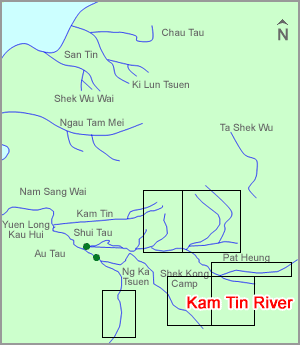
The Kam Tin River is the largest natural drainage system in the eastern region of Yuen Long, although some sections of the river have been concreted and widened as a measure for flood prevention. The 50 km Kam Tin River covers a catchment area of about 44 km2, which is bounded by Kai Kung Leng to the north, Tai To Yan to the east and Tai Mo Shan to the southeast. Flowing from southeast to northwest, Kam Tin River has two main branches, one to the north and the other to the south, which merge near Ko Po Tsuen before joining the main drainage channel leading to inner Deep Bay. Two tidal barriers, in the form of inflatable dams, are located downstream just before the two branches merge, and water upstream of the dams is pumped downstream by a pumping station operated by the Drainage Services Department. River sections downstream of these dams are subject to tidal influence.
Discharge from livestock farms is the suspected major pollution source of Kam Tin River. There are about 60,000 pigs and 800,000 chickens in the catchment of Kam Tin River.
|
| |
|
|
|
|
| |
 |
|
|
|