10. LANDSCAPE AND VISUAL IMPACT ASSESSMENT
10.2 Environmental Legislation, Policies,
Standards and Criteria
10.3 Scope and Content of Study
10.4 Landscape and Visual Impact Assessment
Methodology
10.5 Planning and Development Control Framework
10.7 Landscape Impact Assessment
10.11 Monitoring and Audit Requirements
10.
LANDSCAPE AND VISUAL IMPACT ASSESSMENT
10.1
Introduction
10.1.1.1
This section presents an assessment of the potential landscape and
visual impacts associated with the proposed drainage works recommended in the
Yuen Long Barrage Scheme (PWP Item No. 4178D), along with Improvement of Yuen
Long Nullah (Town Centre Section) (PWP Item No. 4161CD) in accordance with the
Environmental Impact Assessment Ordinance (EIAO) and the requirements of the
EIA Study Brief (No. ESB-307/2018).
10.1.1.2
The assessment includes:
¡ A listing of the relevant environmental legislation and guidelines;
¡ A definition of the scope and contents of the study, including a description of the assessment methodology;
¡ A review of the relevant planning and development control framework;
¡ A baseline study providing a comprehensive and accurate description of the baseline landscape resources, landscape character areas, zone of visual influence and key groups of existing and planned visually sensitive receivers (VSRs).
¡ Identification of the source of landscape and visual impacts;
¡ Recommendation of appropriate mitigation measures and associated implementation programmes;
¡ Assessment of the potential landscape and visual impacts, by taking into account the sensitivity of receivers, prediction of the magnitude of change experienced by the receivers and resulting potential impact significance, before and after the mitigation measures; and
¡ Clear evaluations and explanation with supportive arguments of all relevant factors considered in arriving at the significance thresholds of the landscape and visual impacts.
10.1.1.3
Colour photographs showing baseline conditions (photographs are
augmented to show all approved planned / committed projects), and photomontages
and illustrative materials supporting conclusions are provided and the
locations of all viewpoints are clearly mapped.
Photomontages at representative locations provide comparison between
existing views (augmented to show all approved planned / committed projects);
proposals on Day 1 after completion without mitigation; on Day 1 after
mitigation, and in Year 10 after mitigation.
10.2
Environmental Legislation, Policies, Standards and Criteria
10.2.1.1
The following environmental legislation, standards and guidelines are
applicable to the evaluation of landscape and visual impacts associated with
the construction and operation of the project:
¡ Environmental Impact Assessment Ordinance (Cap 499) and the Technical Memorandum on EIA Process (TM-EIAO), particularly Annexes 3, 10, 11, 18, 20 and 21;
- An Ordinance to provide for assessing the impact on the environment of certain projects and proposals, for protecting the environment and for incidental matters.
- The Technical Memorandum sets out the principles, procedures, guidelines, requirements and criteria for the technical content of an environmental impact assessment study brief or environmental impact assessment report.
¡ Hong Kong Planning Standards and Guidelines;
- The Hong Kong Planning Standards and Guidelines (HKPSG) is a Government manual of criteria for determining the scale, location and site requirements of various land uses and facilities.
¡ Hong Kong 2030 Planning Vision and Strategy Final Report;
- Is a long-term planning strategy to guide future development and provision of strategic infrastructure and to help implement government policy targets in a spatial form.
¡ Landscape Value Mapping of Hong Kong;
- Essential landscape baseline information to provide a systematic reference framework to facilitate landscape assessment and broad environmental assessment of major projects at territorial level.
¡ EIAO Guidance Note No. 8/2010;
- The Environmental Impact Assessment Ordinance, (Cap 499) Guidance Note advises on the requirements in vetting Landscape and Visual Impact Assessment of designated projects under the Technical Memorandum on EIA Process for the Environmental Impact Assessment Ordinance.
¡ Town Planning Ordinance (Cap 131);
- To promote the health, safety, convenience and general welfare of the community by making provision for the systematic preparation and approval of plans for the lay-out of areas of Hong Kong as well as for the types of building suitable for erection therein and for the preparation and approval of plans for areas within which permission is required for development.
¡ Foreshore and Sea-bed (reclamations) Ordinance (Cap 127);
- To provide for the publication of proposals in respect of reclamations over and upon any foreshore and sea-bed; to make provision in respect of objections to the proposals, the payment of compensation and connected matters; and to repeal the Public Reclamations and Works Ordinance (Cap 113, 1984 Ed.) and the Foreshores and Sea Bed Ordinance (Cap 127, 1984 Ed.).
¡ Forests and Countryside Ordinance (Cap 96) and its subsidiary legislation the Forestry Regulations;
- To consolidate and amend the law relating to forests and plants, and to provide for the protection of the countryside.
¡ Country Parks Ordinance (Cap 208);
- To provide for the designation, control and management of country parks and special areas.
¡ Protection of Endangered Species of Animals and Plants Ordinance (Cap. 586);
- To regulate the import, introduction from the sea, export, re-export, and possession or control of certain endangered species of animals and plants and parts and derivatives of those species; and to provide for incidental and connected matters.
¡ SILTech Publication (1991) – Tree Planting and Maintenance in Hong Kong (Standing Interdepartmental Landscape Technical Group) [11-23];
¡ GEO publication (1/2009) – Prescriptive Measures for Man-made Slopes and Retaining Walls;
¡ GEO 1/2011 – Technical Guidelines on Landscape Treatment for Slopes;
- This publication presents guidance on good practice of landscape treatments for man-made slopes and engineering works on natural terrain in Hong Kong.
¡ Land Administration Office Instruction (LAOI) Section D-12 – Tree Preservation;
- It is policy to ensure that no tree is felled unnecessarily nor, where control exists, without the prior consent of Government and that whenever possible, and appropriate, approval to the felling of any tree is made subject to a compensatory landscaping/replanting scheme.
¡ Land Administration Office, Lands Department Practice Note 2/2020 - Tree Preservation and Tree Removal Proposal for Building Development in Private Projects, Compliance of Tree Preservation Clause under Lease;
- This practice note ensures trees are not unnecessarily felled on private lots.
¡ DEVB TC (W) No.2/2012 Allocation of Space for Quality Greening on Roads;
- This circular aims to introduce improvements in greenery, to develop existing greened areas and allow opportunities for greening and landscape during the planning and development of public works projects.
¡ DEVB TC (W) No.3/2012 Site Coverage of Greenery for Government Building Projects;
- This circular sets out the standards and requirements on site coverage of greenery for new government building projects and the methodology of measurement and calculation for the purpose of the required site coverage of greenery.
¡ DEVB TC (W) No.1/2018 Soft Landscape Provisions for Highway Structures;
- This circular updates the policy and requirements for landscape provisions for “highway structures”.
¡ DEVB TC (W) No. 6/2015 – Maintenance of Vegetation and Hard Landscape Features;
- This circular sets out the departmental responsibilities for maintenance of vegetation and hard landscape features.
¡ DEVB TC (W) No. 5/2020 – Registration and Preservation of Old and Valuable Trees;
- This circular sets out the procedures for registration of old and valuable trees on unleased Government land within built-up areas and tourist attraction spots in village areas.
¡ ETWB TCW No. 36/2004 The Advisory Committee on the Appearance of Bridges and Associated Structures (ACABAS);
- This circular updates the membership of the Advisory Committee on the Appearance of Bridges and Associated Structures (ACABAS). Revised guidelines for ACABAS submissions are also included to promote better understanding of the submission requirements.
¡ ETWB TCW No. 5/2005 – Protection of Natural Streams/Rivers from Adverse Impacts Arising from Construction Works;
- This circular provides an administrative framework to better protect all natural streams/rivers from the impacts of construction works. The procedures promulgated under this Circular aim to clarify and strengthen existing measures for protection of natural streams/rivers from government projects and private developments.
¡ DEVB TC(W) No. 04/2020 - Tree Preservation;
- This circular sets out the policy on tree preservation, and the procedures for control of tree felling, transplanting and pruning in Government projects.
¡ WBTC No. 25/1993 – Control of Visual Impact of Slopes;
- This circular outlines the design principles recommended to be used in designing manmade slopes for Public Works projects in order to reduce their adverse visual impact.
¡ WBTC No. 17/2000 – Improvement to the Appearance of slopes in connection with WBTC 25/93;
- This circular outlines the principles and procedures recommended for all departments involved in new slope formation and in upgrading and maintenance of existing slopes for improving the aesthetic and environmental impact of slope works.
¡ Handbook on Tree Management and other relevant guidelines issued by GLTM Section of DevB.
10.2.2 Review of Relevant Planning and Development Control Framework
10.2.2.1
A review will be undertaken of the relevant planning and development
control framework for the landscape study area (100 m beyond the limit of the
works). The relevant OZPs for the project works are the Draft Yuen Long Outline
Zoning Plan No. S/YL/24 and the Approved Nam Sang Wai Outline Zoning Plan No.
S/YL-NSW/8. Extracts of which are
described in Section 10.5 and illustrated on Figure No. 10.02.
10.3
Scope and Content of Study
10.3.1 Project Site Boundary
10.3.1.1
The southern section of the project site boundary follows the edge of
the Yuen Long Nullah from Lung Tin Tsuen to Long Ping Station and includes the
channel. The northern section of the
project boundary stretches from Long Ping Station to the Shan Pui River and
includes the adjacent Wang Lok Street on the west side and Kwong Yip Street and
Shan Pui Ho East Road on the eastern side. The project boundaries are
illustrated in Figures 10.00a, 10.00b, 10.01a & 10.01b – Aerial Photographs and
Site Layout Plans.
10.3.2 Major Works Components
Yuen Long Barrage Scheme
10.3.2.1
Construction of Yuen Long Barrage comprising barrage, link bridge,
pumping stations and E&M control building with associated channel widening
works.
10.3.2.2
Construction of Dry Weather Flow Interceptors and associated link
channels along sides of existing nullah.
10.3.2.3
Decommissioning of existing low flow pumping station / inflatable
dam.
10.3.2.4
Demolition of existing concrete nullah channel base for purposes of
blue-green landscape enhancement proposals.
Kam Tin River Parapet
Modification Works
10.3.2.5
Construction of extensions to existing concrete parapet walls
adjacent to nullah.
Construction and Modification of Parapet Walls along Yuen Long
Nullah, Yuen Long Bypass Floodway, and Sham Chung River
10.3.2.6
Construction concrete parapet walls adjacent to nullah.
10.3.3 Limits of the Study Area
Yuen Long Barrage Scheme
10.3.3.1
The limit of the landscape impact study area is 100m beyond the
boundary of the works as stated in the EIA Study Brief. The limit of the visual
impact assessment is the Zone of Visual Influence (ZVI) during the construction
and operation phases as shown on Figures 10.31 to 10.34.
Kam Tin River Parapet
Modification Works
10.3.3.2
A landscape and visual impact assessment is not required for these
works as no landscape resources will be affected and the visual impacts will be
negligible. The landscape and visual impacts are discussed further in Section
10.12.3.
10.3.3.3
A landscape and visual impact assessment is not required for these
works as no landscape resources will be affected and the visual impacts will be
negligible. The landscape and visual impacts are discussed further in Section
10.12.3.
10.4
Landscape and Visual Impact Assessment Methodology
10.4.1 Scope and Content of Study
¡ Project Site Boundary;
¡ Major Works Components;
¡ Limits of the Study Area.
10.4.2 General Approach
10.4.2.1
Landscape and visual impacts shall be assessed separately for the
construction and operation phases. The assessment of landscape impacts shall
involve the following procedures.
10.4.3 Landscape Impact Methodology
10.4.3.1
Identification of the
baseline Landscape Resources (LRs) and Landscape Character Areas (LCAs) found
within the study area. This is achieved by site
visits and desk-top studies of topographical maps, information databases,
approved EIAs of the committed projects and photographs. Reference is also made to the ‘Landscape
Value Mapping of Hong Kong’ study.
10.4.3.2
Assessment of the degree of
sensitivity to change of the LRs and LCAs.
This is influenced by a number of factors including whether the
resource/character is common or rare, whether it is considered to be of local,
regional, national or global importance, whether there are any statutory or
regulatory limitations / requirements relating to the resource, the quality of
the resource / character, the maturity of the resource, and the ability of the
resource/character to accommodate change. The sensitivity of each landscape
feature and character area is classified as follows:
|
High: |
Important landscape or landscape resource of particularly distinctive
character or high importance, sensitive to relatively small changes |
|
Medium: |
Landscape or landscape resource of moderately valued landscape
characteristics reasonably tolerant to change |
|
Low: |
Landscape or landscape resource, the nature of which is largely
tolerant to change |
10.4.3.3
Identification of potential
sources of landscape change. These are the various elements of the construction works and
operational procedures that would generate landscape change.
10.4.3.4
Identification of the
magnitude of landscape change. The magnitude of the change depends on a number of factors including
the physical extent of the change, the landscape and visual context of the
change – i.e. a set circumstance/facts surrounding the change, the
compatibility of the project with the surrounding landscape; and the time-scale
of the change - i.e. whether it is temporary (short, medium or long term),
permanent but potentially reversible, or permanent and irreversible. Landscape changes have been quantified
wherever possible. The magnitude of landscape change is classified as follows:
|
Large: |
The landscape or landscape resource would
suffer a major change |
|
Intermediate: |
The landscape or landscape resource would
suffer a moderate change |
|
Small: |
The landscape or landscape resource would
suffer slight or barely perceptible changes |
|
Negligible: |
The landscape or landscape resource would
suffer no discernible change |
|
None: |
The landscape or landscape resource would
suffer absolutely no impact |
10.4.3.5
Identification of potential
landscape mitigation measures. These may take the form of adopting alternative designs or revisions
to the basic engineering and architectural design to prevent and/or minimise
adverse impacts; remedial measures such as colour and textural treatment of
building features; and compensatory measures such as the implementation of landscape
design measures (e.g. tree planting, creation of new open space etc.) to
compensate for unavoidable adverse impacts and to attempt to generate
potentially beneficial long term impacts. A programme for the mitigation
measures is provided. The agencies responsible
for the funding, implementation, management and maintenance of the mitigation
measures are identified and their approvals-in-principle are being sought.
10.4.3.6
Prediction of the
significance of landscape impacts before and after the implementation of the
mitigation measures. By synthesising the magnitude of the various changes and the
sensitivity of the various landscape resources it is possible to categorise
impacts in a logical, well-reasoned and consistent fashion. Table 10.1 shows the rationale for
dividing the degree of significance into four thresholds, namely insubstantial,
slight, moderate, and substantial, depending on the combination of a
negligible-small-intermediate-large magnitude of change and a low-medium-high
degree of sensitivity of the LRs / LCAs.
The significance thresholds are defined as follows:
|
Substantial: |
Adverse / beneficial impact where the proposal would cause significant
deterioration or improvement in existing landscape quality |
|
Moderate: |
Adverse / beneficial impact where the proposal would cause a
noticeable deterioration or improvement in existing landscape quality |
|
Slight: |
Adverse / beneficial impact where the
proposal would cause a barely perceptible deterioration or improvement in
existing landscape quality |
|
Insubstantial: |
No discernible change in the existing
landscape quality |
|
None |
Absolutely no change in the existing
landscape quality |
Table 10.1: Relationship between Receptor Sensitivity and Magnitude of Change in Defining Impact Significance
|
Magnitude
of Change |
|
Large |
|
|||
|
Intermediate |
||||||
|
Small |
||||||
|
Negligible |
||||||
|
|
|
None |
||||
|
|
|
|
Low |
Medium |
High |
|
|
|
|
|
Receptor Sensitivity (of Landscape Resource, Landscape
Character Area or VSR) |
|
||
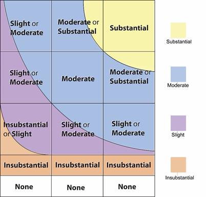
Note:
The colours in the above table categorise the total spectrum
of impacts rising from the lowest value at the bottom left corner to the
highest value at the top right corner. It may be seen that for some combination
of classification levels of Magnitude of Change and Receptor Sensitivity, there
are 2 possible impact significance thresholds. When the Magnitude of Change and
Receptor Sensitivity are assessed to be towards to higher ends of each
classification level the resultant impact significance would be deemed to be
the higher of the two impact significance thresholds.
10.4.3.7
Prediction of Acceptability
of Impacts.
An overall assessment of the acceptability, or otherwise, of the impacts
according to the five levels is stated in the conclusion in Section 10.12. The evaluation of
landscape and visual impacts may be classified into five levels of significance
based on type and extent of the effects concluded in the EIA study:
¡ The impact is beneficial if the project will complement the landscape and visual character of its setting, will follow the relevant planning objectives and will improve the overall landscape and visual quality;
¡ The impact is acceptable if the assessment indicates that there will be no significant effects on the landscape, no significant visual effects caused by the appearance of the project, or no interference with key views;
¡ The impact is acceptable with mitigation measures if there will be some adverse effects, but these can be eliminated, reduced or offset to a large extent by specific measures;
¡ The impact is unacceptable if the adverse effects are considered too excessive and are unable to mitigate practically; and
¡ The impact is undetermined if significant adverse effects are likely, but the extent to which they may occur or may be mitigated cannot be determined from the study. Further detailed study will be required for the specific effects in question.
10.4.4 Broad Brush Tree Survey Methodology
10.4.4.1
A broad brush tree survey in accordance with the EIA Study Brief is
described in Section 10.5.4. The
survey provides baseline information on the existing trees within the project
site boundary and identifies dominant tree species, maturity, rarity and any
plant species of conservation interest.
10.4.4.2
Existing trees within the project boundary were surveyed in groups
according to the location, in which the following information was identified
for each tree group:
¡ Tree group number;
¡ Botanical name and Chinese name of the main species found in the group;
¡ Approximate number of trees in the group;
¡ An assessment of average tree form (good / fair / poor) for each species found in each group;
¡ An assessment of average tree health (good / fair / poor) for each species found in each group;
¡ An assessment of average amenity value (high / medium / low) for each species found in each group; and
¡ Additional remarks are provided on the estimated approximate age range of the trees.
10.4.5 Visual Impact Methodology
10.4.5.1
Landscape and visual impacts are assessed separately for the
construction and operation phases. The
assessment of visual impacts has involved the following procedures.
10.4.5.2
Identification of the
Visual Envelope and Zones of Visual Influence (ZVI) during the construction and
operation phases. The visual envelope is the area from which any part of the proposed
project can be seen and may contain areas, which are fully visible, partly
visible and non-visible from the project. Identification of the visual envelope
and ZVI is achieved by site visits and desk-top studies of topographic maps and
photographs to determine the visibility from various locations.
10.4.5.3
Identification of the
Visually Sensitive Receivers (VSRs) within the ZVI at construction and
operation phases. These are the people who
would reside within, work within, play within, or travel through, the ZVI. VSRs
at both existing and committed developments will be considered in this
assessment.
10.4.5.4
Assessment of the degree of sensitivity to change of the VSRs. Factors considered include:
¡ The type of VSRs, classified according to whether the person is at home, at work, at play, or travelling. Those who view the impact from their homes are considered to be highly sensitive as the attractiveness or otherwise of the outlook from their home will have a substantial effect on their perception of the quality and acceptability of their home environment and their general quality of life. Those who view the impact from their workplace are considered to be only moderately sensitive as the attractiveness or otherwise of the outlook will have a less important, although still material, effect on their perception of their quality of life. The degree to which this applies depends on whether the workplace is industrial, retail or commercial. Those who view the impact while taking part in an outdoor leisure activity may display varying sensitivity depending on the type of leisure activity. Those who view the impact while travelling on a public thoroughfare will also display varying sensitivity depending on the speed of travel.
¡ Other factors which are considered (as required by EIAO GN 8/2010) include the value and quality of existing views and views from planned developments, the availability and amenity of alternative views, the duration or frequency of view, and the degree of visibility.
10.4.5.5
The sensitivity of VSRs is classified as follows:
|
High: |
The VSR is highly sensitive to any change in their viewing experience |
|
Medium: |
The VSR is moderately sensitive to any change in their viewing
experience |
|
Low: |
The VSR is only slightly sensitive to any change in their viewing
experience |
10.4.5.6
Identification of the
relative numbers of VSRs. This is expressed in terms of
whether there are very few, few, many or very many VSRs in any one category of
VSR.
10.4.5.7
Identification of potential
sources of visual impacts. These are the various elements of the construction works and
operational procedures that would generate visual impacts.
10.4.5.8
Assessment of the potential magnitude of visual change. Factors considered include:
|
Duration
and Frequency of the impact: |
Temporary / Permanent: This refers to the long term presence of the
visual change – whether it is experienced by the VSR for the whole duration
of the construction phase or operation phase, or only part thereof. Intermittent / Continuous: This refers to short term frequency of the
visual change - is it always visible (continuous) or only at certain times
(intermittent). For example,
travelling VSRs may only see the source intermittently as they travel along
their journey, whereas residential VSRs may have continuous views from their
living room. |
|
Reversibility
of the impact: |
Reversible / Irreversible |
|
Compatibility
of the project with the Visual Backdrop: |
High / Medium / Low |
|
Distance
of the source of impact from the viewer: |
Shortest distance measured in metres (m) between the VSR and the
source. |
|
Degree
of visibility of Source(s) of Visual Impact: |
Full: virtually full uninterrupted view of the source of impact Partial: partial view of the source of impact which is slightly hidden
by intervening elements such as buildings, vegetation etc. Obscured: partial view of the
source of impact which is largely hidden by intervening elements such as
buildings, vegetation etc. |
|
Scale
of the development |
Small / Medium / Large |
|
Potential
Blockage of Existing Views |
Full / Partial / Slight / Negligible:
The degree to which the source of the impact blocks existing open
views currently experienced by the VSR. |
10.4.5.9
The magnitude of visual change is classified as follows:
|
Large: |
The VSRs would suffer a major change in their viewing experience; |
|
Intermediate: |
The VSRs would suffer a moderate change in their viewing experience; |
|
Small: |
The VSRs would suffer a small change in their viewing experience; |
|
Negligible: |
The VSRs would suffer no discernible change in their viewing
experience; |
|
None |
The VSRs would suffer absolutely no change in their viewing
experience. |
10.4.5.10
Identification of potential
visual mitigation measures. These may take the form of adopting alternative designs or revisions
to the basic engineering and architectural design to prevent and/or minimise
adverse impacts; remedial measures such as colour and finishing treatment of building
features; and compensatory measures such as the implementation of landscape
design measures (e.g. tree planting, creation of new open space etc.) to
compensate for unavoidable adverse impacts and to attempt to generate
potentially beneficial long term impacts. A programme for the mitigation
measures shall be provided. The agencies
responsible for the funding, implementation, management and maintenance of the
mitigation measures shall be identified and their approval-in-principle shall
be sought.
10.4.5.11
Prediction of the
significance of visual impacts before and after the implementation of the
mitigation measures. By synthesising the magnitude of the various visual changes and the
sensitivity of the VSR, and the number of individuals in the VSR that are affected,
it is possible to categorise the degree of significance of the impacts in a
logical, well-reasoned and consistent fashion. Table 10.1 shows the rationale for dividing the
degree of significance into four thresholds, namely, insubstantial, slight,
moderate and substantial, depending on the combination of a negligible / small
/ intermediate / large magnitude of change and a low / medium / high degree of
sensitivity of VSRs. Consideration is
also given to the relative numbers of individuals in the VSRs in predicting the
final impact significance - exceptionally low or high numbers of individuals in
a VSR may change the result that might otherwise be concluded from Table 10.1. The significance of the visual
impacts is categorised as follows:
|
Substantial: |
Adverse / beneficial impact where the proposal would cause significant
deterioration or improvement in existing visual quality perceived by the
general population; |
|
Moderate: |
Adverse / beneficial impact where the proposal would cause a
noticeable deterioration or improvement in existing visual quality perceived
by the general population; |
|
Slight: |
Adverse / beneficial impact where the proposal would cause a barely
perceptible deterioration or improvement in existing visual quality perceived
by the general population; |
|
Insubstantial: |
No discernible change in the existing visual quality perceived by the
general population; |
|
None |
Absolutely no change in the existing visual quality perceived by the
general population. |
10.4.5.12
Prediction of Acceptability
of Residual Impacts An overall assessment of the acceptability or otherwise of the
residual impacts 10 to 15 years after implementation of visual mitigation
measures, according to the five criteria set out in Annex 10 of the EIAO TM.
10.4.6.1
Representative views from various locations have been selected to
illustrate the effectiveness of the proposed impact mitigation proposal and
residual impacts of the development in both short and long terms. Photomontages
illustrating the proposed works and the recommended mitigation measures as well
as the confirmed projects and mitigation measures are listed in Section
10.4.8. The locations of the selected viewpoints are indicated in Figures 10.31 to 10.34 with the viewpoints
illustrated in Figures 10.50a to 10.59d. The photomontages illustrate the
proposed development under the following scenarios:
¡ Existing Baseline Conditions in June 2020;
¡ Day 1 of completed works without mitigation measures;
¡ Day 1 of the completed works with mitigation measures; and
¡ The completed works with mitigation after 10 years.
10.4.7 Assumptions and Limitation
10.4.7.1
In accordance with EIAO Guidance Note 8/2010 (paragraph 3.7(a))
approved projects should form part of the baseline conditions. Therefore the
landscape and visual outcomes (including proposed landscape and visual
mitigation measures) of approved projects currently under construction will be
included as part of the baseline conditions.
10.4.7.2
It is assumed that funding, implementation, management and
maintenance of the landscape and visual mitigation proposals can be
satisfactorily resolved according to the principles in DEVB TC(W) No.
6/2015. All mitigation proposals in the
EIA report shall be practical and achievable within the known parameters of
management and maintenance. The suggested agents for the funding and
implementation (and subsequence management and maintenance) are indicated.
Approvals-in-principle to the implementation, management and maintenance of the
proposed mitigation measures are being sought from the appropriate authorities.
10.4.8 Concurrent Projects
10.4.8.1
Proposed projects that are yet to be approved that
fall within the ZVI and which should be taken account of in the visual impact assessment
shall be identified . The visual impacts of these concurrent projects are to be
taken into account in the cumulative impact assessment.
10.5
Planning and Development Control Framework
10.5.1 Review of the Outline Zoning Plans (OZPs)
10.5.1.1
A review of the existing and planned development framework for the
proposed works and for the surroundings in Yuen Long has been considered. It
aims to identify issues for the neighbouring planned land uses, to identify
potential resources and sensitive receivers, and to ensure a high compatibility
between the proposed project and the surroundings.
10.5.1.2
The Study Area is largely covered by OZPs. These are the Draft Yuen Long Outline Zoning Plan
No. S/YL/24 and the Approved Nam
Sang Wai Outline Zoning Plan No. S/YL-NSW/8, and based on desktop study, there
will not be any impact to either. The review of OZPs has not only included a
review of the plans, but also of the ‘Notes’ and “Explanatory Statements’ which
accompany, and form part of, these plans. Extracts of the relevant OZP’s are
provided on Figure 10.02.
10.5.2 Draft Yuen Long Outline Zoning Plan No. S/YL/24
10.5.2.1
The following describes the land use zonings on land falling within
the boundaries of the landscape assessment area which are always permitted and
which may be permitted by the Town Planning Board, with or without conditions
on application.
¡ Other Specified Uses (“OU”): This zoning covers land for a number of specified uses. These fall under the following specific areas as outlined below:
- Business; Land at Tung Tau, Area 7 is zoned “OU” annotated “Business” or “Business(1)”. Land zoned for this purpose is primarily intended for general business uses. A mix of information technology and telecommunications industries, non-polluting industrial, office and other commercial uses are always permitted in new “business” buildings.
- Petrol Filling Station; This zone is intended primarily for the provision of petrol filling stations. Three petrol filling stations are located in Areas 6, 9 and 14. Development in the zone is restricted to a maximum building height of 1 storey excluding basement(s).
- Sewage
Treatment Works; This zone is intended primarily for the provision of
sewage treatment works. A sewage treatment plant is located in Area 19.
Development in the zone is restricted to a maximum building height of 2 storeys
excluding basement(s).
- Industrial
Estate; This zone is intended to provide/reserve land for the development
of an industrial estate for industries to be admitted by the Hong Kong Science
and Technology Parks Corporation according to the criteria set by the
Corporation. Industries to be included would normally not be accommodated in
conventional industrial buildings because of their specific requirements. This
zone, located in Area 19, has been developed as the Yuen Long Industrial
Estate.
- LRT
Terminus with Commercial/Residential Development; This zone is intended
primarily for Light Rail terminus with residential and/or commercial uses, and
other supporting public transport facilities and has been developed as “Sun
Yuen Long Centre”. It is located in Area 15. Development is restricted to a
maximum domestic GFA of 66,460m2, a maximum non-domestic GFA of 25,940m2 and a
maximum building height of 32 storeys excluding basement(s).
- Public Car Park with Ground Floor Retail Shops; This zone is intended primarily for public car park with ground floor retail shops. Three sites have been developed under this zoning. Two public car parks with ground floor retail shops are located in Areas 2 and 5. Development is restricted to a maximum plot ratio of 9.5 and a maximum building height of 30 storeys excluding basement(s). The one in Tung Tau business area, Area 7, is designated as “OU (Public Car Park with Ground Floor Retail Shops(1))” and is restricted to a maximum plot ratio of 5 and a maximum building height of 15 storeys excluding basement(s).
- Public Car Park and Petrol Filling Station with Ground Floor Retail Shops; This zone is intended primarily for public car park and petrol filling station with ground floor retail shops. A site has been developed under this zoning in Area 10. It is restricted to a maximum plot ratio of 9.5 and a maximum building height of 25 storeys excluding basement(s).
- Public Car Park to include Retail and Residential Uses; This zone is intended primarily for public car park with retail and residential uses. A site has been developed under this zoning in Area 6. It is restricted to a maximum domestic GFA of 11,356m2, a maximum non-domestic GFA of 11,777m2 and a maximum building height of 25 storeys excluding basement(s).
¡ Open space (“O”): This zone is intended primarily for the provision of outdoor open-air public space for active and/or passive recreational uses serving the needs of local residents as well as the general public. Facilities of particular importance are the Town Park in Area 6, the sports ground in Area 7 and the Town Square in Area 10. Apart from providing recreational and sports facilities, the open space will also serve as a buffer area.
¡ Comprehensive Development Area (“CDA”): This zone is intended for comprehensive development/redevelopment of the area for residential and/or commercial uses with the provision of open space and other supporting facilities. The zoning is to facilitate appropriate planning control over the development mix, scale, design and layout of development, taking account of various environmental, traffic, infrastructure and other constraints.
¡ Residential (Group A) (“R(A)”): This zone is intended primarily for high-density residential developments. Commercial uses are always permitted on the lowest three floors of a building or in the purpose-designed non-residential portion of an existing building.
¡ Residential (Group B) (“R(B)”): Residential
sites within this zone are in Areas 6, 13, 14 and 16 mainly located in the
southern part of the Town. This zone is intended primarily for medium-density
residential development where commercial uses serving the residential
neighbourhood may be permitted on application to the Board.
¡ Residential (Group E) (“R(E)”): This
zone covers an area at Wang Chau Road in Area 5 and part of Tung Tau Industrial
Area to the west of Wang Yip Street West and to the north of Tak Yip Street in
Area 7. This zone is intended primarily for phasing out of existing industrial
uses through redevelopment (or conversion) for residential use on application
to the Board. Whilst existing industrial uses will be tolerated, new industrial
developments are not permitted in order to avoid perpetuation of
industrial/residential interface problems. The developers will be required to
submit adequate information to demonstrate that the new residential development
will be environmentally acceptable, and suitable mitigation measures, if required,
will be implemented to address the potential industrial/residential interface
problems.
¡ Village Type Development (“V”): The
planning intention of this zone is to reflect existing recognized and other
villages, and to provide land considered suitable for village expansion and
reprovisioning of village houses affected by Government projects. Land within
this zone is primarily intended for development of Small Houses by indigenous
villagers. It is also intended to concentrate village type development within
this zone for a more orderly development pattern, efficient use of land and
provision of infrastructures and services. Selected commercial and community
uses serving the needs of the villagers and in support of the village
development are always permitted on the ground floor of a New Territories
Exempted House. Other commercial, community and recreational uses may be
permitted on application to the Board.
¡ Government, Institution or Community (“G/IC”): This zone is intended primarily for the provision of GIC facilities
serving the needs of the local residents and/or a wider district, region or the
territory. It is also intended to provide land for uses directly related to or
in support of the work of the Government, organizations providing social services
to meet community needs, and other institutional establishments.
10.5.3 Nam Sang Wai Outline Zoning Plan No. S/YL-NSW/8
10.5.3.1
The object of the plan is to specify the broad land use zonings and
major transport networks so that development within the area can be put under
statutory planning control.
10.5.3.2
The following describes the land use zonings on land falling within
the boundaries of the plan which are always permitted and which may be
permitted by the Town Planning Board, with or without conditions on
application.
¡ Residential (Group D) (“R(D)”): The planning intention of this zone is primarily to improve and upgrade the existing temporary structures within the rural area to permanent buildings. Replacement housing for temporary structures shall not result in a total redevelopment in excess of a maximum building area of 37.2m2 and a maximum building height of 2 storeys (6m).
¡
Other Specified Uses (“OU”):
- “OU (Comprehensive Development and Wetland Enhancement Area)” “OU(CDWEA)”: Within the “OU(CDWEA)” zone, the ecological value of the existing continuous and contiguous fish ponds should be conserved and the “precautionary approach” and “no-net-loss in wetland” principle shall apply. According to the “precautionary approach”, these existing continuous and contiguous fish ponds are to be protected and conserved in order to maintain the ecological integrity of the Deep Bay wetland ecosystem as a whole. “No-net-loss in wetland” can refer to both loss in area and function. No decline in wetland or ecological functions served by the existing fish ponds should occur.
- “OU(Comprehensive Development to include Wetland Restoration Area)” (“OU(CDWRA)”: The planning intention of this zone is to provide incentive for the restoration of degraded wetlands adjoining existing fish ponds, and to encourage the phasing out of sporadic open storage and port back-up uses on degraded wetland. This can be achieved through comprehensive residential and/or recreational development to include wetland restoration area. Development or redevelopment schemes on the degraded wetlands directly adjoining areas of the existing continuous and contiguous fish ponds should include wetland restoration and buffer proposals to separate the development from and minimize its impact on the fish pond areas. Any new building should be located farthest away from Deep Bay.
- “OU(Pumping Station)”: This zone covers a storm water pumping station and a sewage pumping station near Shan Pui Chung Hau Tsuen which are already in operation handling prevention of flooding and sewage disposal of the area including Yuen Long Kau Hui respectively.
- Conservation Area (“CA”): The planning intention of this zone is to conserve the ecological value of the wetland and fish ponds which form an integral part of the wetland ecosystem in the Deep Bay Area and function as a substantial source of food supply for birds and as an important habitat for roosting and foraging of waterbirds. The “no-net-loss in wetland” principle is adopted for any change in use within this zone. “No-net-loss in wetland” can refer to both loss in area and function. No decline in wetland or ecological functions served by the existing fish ponds should occur. Fragmentation of continuous and contiguous fishpond habitats within the “CA” zone should be avoided.
10.5.4 Committed and Approved Projects Under Construction
10.5.4.1
In accordance with EIAO Guidance Note 8/2010 (paragraph 3.7a))
approved projects to be completed before commencement of this project should
form part of the baseline conditions. For ease of understanding, the baseline
study describes what will be in existence once the current approved and
committed projects already under construction are completed. It is upon the
baseline that the impacts of future construction and operation of this project
will be felt and it is this project’s impact on that baseline that is assessed
qualitatively and quantitatively in this LVIA.
10.6
Baseline Study
10.6.1 Landscape and Visual Study Area
10.6.1.1
It is concluded that there is no conflict between the proposal and
the current relevant planning and development control framework for existing
land, as the proposed development is consistent with the current designated land
uses on existing land. There is also no conflict with existing land zoned Green
Belt and Open Space as the predicted extent of area of works does not encroach
into the aforementioned land zonings.
10.6.2 Broad Brush Tree Survey
10.6.2.1
A broad-brush tree survey was undertaken within the project boundary
area (refer Appendix 10.1). The
survey includes tree group survey data and tree group plans recording
approximate numbers of trees (with estimated stem diameter over 95 mm diameter
at 1.3 m above ground). (As certain
details of the project are yet to be confirmed, only a broad assessment has
been made on the potential impacts on the trees.)
10.6.2.2
Two types of Tree Groups are identified. Tree Groups A (TGA) refers
to tree groups located within the Site Boundary. Tree Groups B (TGB) refers to
tree groups located outside the project boundary but within the extent of the
landscape assessment boundary (ie. within 100m from the project site boundary.
10.6.2.3
Based on the broad-brush tree survey, it is estimated that there are
1436 trees within the project boundary, consisting of 80 identified tree
species. (The approximate numbers of
trees within TGB groups remains to be confirmed). The plans showing the
existing and affected trees under this Project can be found in Figures 10.70, 10.71 & 10.72.
10.6.2.4
There are no existing trees included in the Register of Old and
Valuable Trees (as defined in DEVB TC(W) No. 5/2020) within the assessment
area.
10.6.2.5
A total of 17 trees within the assessment area can be considered as
Trees of Particular Interest (TPIs according to the criteria in DEVB TC(W) No.
4/2020), of which 6 nos. are located within the site boundary. All identified
TPI trees have a DBH larger than 1m. Species include Ficus elastica, Ficus
microcarpa, Ficus virens and Melia
azedarach.
10.6.2.6
The design proposal has been considered to minimise the number of
trees affected. The actual number of trees affected by the works and the number
of compensatory trees required will be determined by a detailed tree survey at
the Detailed Design Stage of the project. The estimated number of trees
affected is 27 nos., details of which can be found in Figure 10.73. Tree preservation
and compensatory tree planting will be carried out in accordance with DEVB
TC(W) No. 4/2020 - Tree Preservation.
10.6.3 Landscape Resources
10.6.3.1
The baseline LRs that will be affected during the construction phase
and operation phase, together with their sensitivity to change, are described
below. The locations of the LRs are mapped on Figures 10.10 through 10.13 and photographs of
the LR’s are provided on Figures 10.14 – 10.16.
For ease of reference and co-ordination between text, tables and drawings, each
LR is given an identity number. The below Table 10.2 listed LRs represent
the baseline condition after completion of the approved committed projects.
This includes new landscape elements which are planned to be implemented as
part of the approved committed projects not yet identified and will in fact
exist during commencement of the proposal so will therefore form part of the
baseline condition for the proposal.
Table 10.2: Landscape Resources
|
ID. |
Landscape Resources |
|
LR1A |
Yuen Long Town Nullah (upper reaches) Approximate Area: 6.3ha. This is a concrete lined drainage nullah (ranging from ~11m to 70m width) that runs from the south from Shap Pat Heung Road, through Yuen Long town centre, north to where it meets a fibre dam near Lau Yip Street that separates it from the lower section of nullah and the Shan Pui River. While the nullah is not publicly accessible (except for DSD maintenance) and is generally devoid of planting, it provides an open view corridor and well-used pedestrian network along its banks. As it marks the approximate alignment of the original Yuen Long River and runs through the centre of the urban area, it holds a strong local identity of historical and cultural significance. It performs a highly significant drainage function essential to preventing flooding of the adjacent urban areas. There are approximately 5 trees within this area. Although it is generally lacking in vegetation (the lower section has vegetated banks), the nullah attracts birds and supports some fish although this varies greatly with season and flow conditions. Water levels vary seasonally and during the winter the nullah is generally dry except for a central low flow channel and inflow channels. In the summer, the water level rises and falls depending on rainfall. Nullahs are common features throughout Hong Kong. Whilst the Yuen Long Nullah performs a significant drainage function and has considerable cultural and historical significance within the Yuen Long district its value is considered to be of only local importance. Provided the flow capacity of the nullah channel is not significantly altered, it is reasonably tolerant to change. The sensitivity is therefore assessed as Medium. |
|
LR1B |
Yuen Long Town Nullah (lower
reaches) Approximate Area: 0.09ha. The lower reaches of the nullah below the fibre dam to the promontory opposite the Hong Kong School of Motoring share the same characteristics as the upper section except that the nullah bed is generally always flooded. This section connects directly to the Shan Pui River which is tidal. It has vegetated banks and the silty bed exposed at low tide attracts wading birds. Whilst the Yuen Long Nullah performs a significant drainage function and has considerable cultural and historical significance within the Yuen Long district its value is considered to be of only local importance. It is reasonably tolerant to change. The sensitivity is therefore assessed as Medium. |
|
LR2 |
Trees adjacent
to Nullah – Shan Pui Ho East Road Approximate Nos.: 81. Existing mature trees line the
east bank of Yuen Long Town Nullah from Lau Yip Street to the promontory at
the end of the nullah. As this is a mature resource that cannot easily be replaced and due to
the contribution to amenity through the provision of greening and shade and
the provision of urban contribution as a habitat to local wildlife
(particularly birds), the sensitivity assessed as High. |
|
LR3 |
Street and Roadside Trees Approximate Nos.: 392. Approximately 392 nos. of existing trees lie outside the site
boundary, but within the 100m LIA study area, these comprise 63 identified
tree species. Approximately
12 nos. of these trees will be affected by the
construction of the barrage pumping stations and E&M control building
works. Due to the congested urban space, trees within Yuen Long Town Centre
are mainly found near the nullah, in and around rest gardens and playgrounds,
while other street trees within the study area mainly line roadways, bicycle
paths and pedestrian pavements. Most of the trees comprise common amenity
species such as Melaleuca cajuputi subsp. Cumingiana, and Ficus
benjamina. However, 12 nos. of trees are
considered as TPIs and are all rated as medium or high amenity value. Due to
the contribution the mature trees make to the dense urban area in terms of
amenity, greening, shading and urban wildlife habitat provision, and as they
have a low tolerance to change their sensitivity is assessed as High. |
|
LR4 |
On Hing Playground Approximate Area: 0.15ha. This playground is located at On Leung Lane. There are
approximately 10 trees within this playground, mainly planted within the
sitting-out area along the northern side of the football pitch. On the east
side of the playground in the car park is a large Ficus microcarpa, designated
as a TPI, with a height of 15m and a crown spread of 20m, giving it a high
amenity value. The sitting-out and play facilities
provided an important leisure open space for the public. Since this is the
only large soccer pitch in the local area, its utilization rate is high. The
adjacent amenity trees are also high in landscape value. Considering its
important function for the local residents and its relatively low tolerance
to change, the sensitivity is assessed as High. |
|
LR5 |
Tai Pei Tau Rest Garden Approximate Area: 0.2ha. The Rest Garden is a passive recreational space containing a sitting-out area adjacent to an open car park in Fung Lok Lane. There are approximately 30 trees within this area. Benches, rain-shelters, and pavilions provide passive recreational
facilities for the local residents. 5 Ailanthus fordii trees are on
the eastern side of the garden, and protected under Cap 96, recorded as “NT”
in Rare and Precious Plants in Hong Kong.
On the north east side of the playground in the car park a large Ficus
microcarpa TPI, with a height of 15m and a crown spread of
17m. Due to its important function for the local
residents and its prominent location adjacent to Cheung Shing Path, and its
low tolerance to change, the sensitivity is assessed as High. |
|
LR6 |
Chung Sing Path Playground Approximate Area: 0.2ha. The playground is adjacent to Chung Sing Path, next to CCC Chun Kwong
Primary School, and has 2 basketball courts. The west boundary of the court
is a sitting out area. The basketball courts are frequently used by local
residents. There are approximately 20 trees within this area. The trees and
shrubs are of common species and provide shade and amenity for the passive
sitting out area of the playground. Due to its important function for the
local residents, its prominent location adjacent to Chung Sing Path and its
relatively low tolerance to change, the sensitivity is assessed as High. |
|
LR7 |
Yuen Long Children’s Playground Approximate Area: 0.3ha. This playground is located on Yuen Long Hong Lok Road, and
includes two basketball courts and children play facilities, which meet an
important need for the local residents. There are approximately 10 trees
within this playground. Considering its important function, and the presence
of large mature existing trees providing greening and shade for local
residents, and its low tolerance to change, the sensitivity is
assessed as High. |
|
LR8 |
Kik Yeung Road 5-A-Side Football Pitch Approximate Area: 0.2ha. This public football ground is well used by locals and includes a
small seating area adjacent to Hi Lee Path. There are approximately 20 trees
within this area. It provides an important function for the local residents
and the pitch is surrounded by shrubs and trees in raised planters, providing
greening, shade and amenity adjacent to the transportation node in Yuen Long
(West) Bus Terminus. As this resource has a relatively low tolerance
to change, the sensitivity is assessed as High. |
|
LR9 |
Cheong Shing Path Approximate Length: 150m. This path is on the western side of the nullah, between Castle Peak
Road and Kau Yuk Road. Tai Pei Tau Rest Garden is adjacent to this walkway.
The path contains raised planters, numerous benches and amenity trees. There
are approximately 21 trees within this area. It provides a peaceful retreat
for community members and pedestrians. Planting comprises common species with
low diversity and trees are small and immature and relatively easy to
replace. Given the reasonable tolerance to change, the sensitivity is
assessed as Medium. |
|
LR10 |
Chung Sing Path Approximate Length: 150m. This path is a major pedestrian route (~6m wide and ~150m long) along the east side of the nullah between Castle Peak Road and Kau Yuk Road. The CCC Chun Kwong Primary School, basketball court and playground lie adjacent to this walkway. Many large trees line this path and provide an important greening
and shading element for the space. There are approximately 17 trees within
this area. As the trees are mature and their quality is good, the landscape
quality is high and the tolerance to change is low, the sensitivity is
assessed as High. |
|
LR11 |
Yuen Fat Path Approximate Length: 160m. Yuen Fat Path and the north-south running pavement along Sau Fu Street is located on the east side of the nullah. There are many large mature trees along this section, which provide a dense canopy which acts as an effective buffer between the pathway and the busy Castle Peak Road. There is an attractive sitting out area where Yuen Fat Path meets
Sau Fu Street, and large existing trees provide greening and shade for local
residents. There are approximately 23 trees within this area. Due to the
maturity of the resource, its value to the local community and its low
tolerance to change, the sensitivity is assessed as High. |
|
LR12 |
Hi Lee Path Approximate Length: 150m. This path is on the western side of the nullah between Castle Peak Road to On Ning Road. The path is adjacent to the Kik Yeung Road 5-A-Side Football Pitch. There are approximately 14 trees within this area. Trees are planted in at-grade tree pits and in raised planters with shrubs and ground cover. Benches and trellises provide resting and social opportunities for local residents along the path. As the vegetation is of common species and the trees are relatively immature, this LR has reasonable tolerance to change and the sensitivity is assessed as Medium. |
|
LR13 |
Po Fai Path Approximate Length: 120m This Path is a major and important thoroughfare from the West Rail Long Ping Station and Yuen Long On Ning Road. There are approximately 2 trees within this area., which are immature and of small size. The landscape quality is low and this LR has a reasonable tolerance to change and therefore the sensitivity is assessed as Medium. |
|
LR14a |
Long Yip Street – Sitting Out Area A Approximate Area: 0.17ha. This sitting out area North of Long Ping MTR Station is on decking above the nullah and currently does not have good pedestrian access (surrounded on 3 sides by busy roads and one side by the nullah and a large pipe runs along Long Yip Street hindering access from that side), is underused and poorly maintained. There are approximately 14 trees within this area. The few existing trees are small without significant canopies and do not provide good amenity or shade. The landscape quality is low, but it provides a potentially useful open space function and it provides an element of greening adjacent to the Long Ping Station and road. As it is reasonably tolerant to change the sensitivity is assessed as Medium. |
|
LR14b |
Long Yip Street – Sitting Out Area B Approximate Area: 0.07ha. This sitting out area (~0.07h) is at the corner of Long Yip Street and Wang Lok Street. It has good access, many mature trees, and contains pergolas with seating. Since it is highly used, and the mature trees provide important shading and greening adjacent to a major pedestrian thoroughfare, the sensitivity is assessed as High. |
|
LR15 |
Vegetation Along Nullah Banks Approximate Area: 1.85ha. North of Long Ping Station, the nullah banks are lined with perforated concrete blocks planted with a range of grasses and small shrubs. There are approximately 68 trees within this area. While the quality of the planting is monotonous, and of low species diversity, its greening effect provides visual relief and habitat compared to the concrete banks in the other portions of the nullah. Given that the planting can be relatively easily reinstated, the sensitivity is assessed as Medium. |
|
LR16 |
Tung Tau Wai Children’s Playground Approximate Area: 0.04ha. The playground lies along the west edge of Wang Lok Street, near the location of the current fibre dam. It is small in size and contains limited playground equipment, a small paved open space, and a few sheltered benches. There are approximately 10 trees within this area. As there is very little tree or shrub planting or other amenities, this playground has a reasonable tolerance to change and the sensitivity is therefore assessed as Medium. |
|
LR17 |
Shan Pui Chung Hau Siting Out Area Approximate Combined Area: 0.06ha. These two sitting out areas lie along the eastern edge of Shan Pui Ho East Road and serve the village development of Shan Pui Chung Hau Tsuen. They are paved with pergolas, seating, table tennis tables, and various exercise equipment. They are the only facilities serving this area and are integrated within the housing area. There are approximately 4 trees within this area. Their quality is poor and they lack mature planting and their tolerance to change is reasonable. Their sensitivity is therefore assessed as Medium. |
|
LR18 |
Vegetation Within Village Approximate Area: 1.35ha. This vegetation lies within Tai Kiu Tsuen village and adjacent to
Shan Pui Chung Hau Tsuen and tends to be generally unmanaged, with a low
diversity of species. There are approximately 118 trees within these areas.
Within Tai Kiu Tsuen, there are 2 trees designated as TPI. Where adjacent to
buildings, trees provide shade and screening of the surrounding urban area.
Although these areas contains common varieties and a low diversity of plant species,
it provides an important green buffer to the village. It includes some large
mature trees and the sensitivity is assessed as High. |
|
LR19 |
Vegetation Adjacent to Nullah Edge – Wang Lok Street Approximate Area: 1.10ha. This strip of vegetation lies outside but adjacent to the nullah
channel, contains many mature trees, some of a substantial size, which
provide an ecological habitat adjacent to the watercourse. There are
approximately 107 trees within this area, of which approximately 15 nos. will be affected by the construction of the barrage pumping
stations and E&M control building works. Due to the large size of trees
and the diversity of plant species, the sensitivity is assessed as High. |
|
LR20 |
Shan Pui River Peninsula Approximate Area: 0.06ha. This peninsula is at the termination of Shan Pui Ho East Road, and
serves as a sitting out and view point for where the nullah meets the Shan
Pui River. It contains seating and several large mature trees. There are
approximately 14 trees within this area.
Due to the unique and commanding location and the maturity of the
trees, the sensitivity is assessed as High. |
|
LR21 |
Shan Pui River and Wetland Approximate Area: 4.35ha. The Yuen Long Nullah flows into this tidal river and associated
wetland. The west bank has been modified but the east bank is largely natural
and contains an area of mangrove. This lies on the edge of the Nam Sang Wai
wetland area of fishponds and has high conservation value with a low tolerance
to change. The sensitivity is assessed as High. |
10.6.3.2
The sensitivities for the Landscape Resources identified are
summarised in the Table 10.3 below.
Table 10.3: Sensitivity of Landscape Resources
|
ID. |
Description |
Sensitivity to Change (Low, Medium,
High) |
|
LR1A |
Yuen Long Town Nullah (upper reaches) |
Medium |
|
LR1B |
Yuen Long Town Nullah (lower reaches) |
Medium |
|
LR2 |
Trees adjacent to Nullah – Shan Pui Ho
East Road |
High |
|
LR3 |
Street and Roadside Trees |
High |
|
LR4 |
On Hing Playground |
High |
|
LR5 |
Tai Pei Tau Rest Garden |
High |
|
LR6 |
Chung Sing Path Playground |
High |
|
LR7 |
Yuen Long Children’s Playground |
High |
|
LR8 |
Kik Yeung Road 5-A-Side Football Pitch |
High |
|
LR9 |
Cheong Shing Path |
Medium |
|
LR10 |
Chung Sing Path |
High |
|
LR11 |
Yuen Fat Path |
High |
|
LR12 |
Hi Lee Path |
Medium |
|
LR13 |
Po Fai Path |
Medium |
|
LR14A |
Long Yip Street – Sitting Out Area |
Medium |
|
LR14B |
Long Yip Street – Sitting Out Area |
High |
|
LR15 |
Vegetation Along Nullah Banks |
Medium |
|
LR16 |
Tung Tau Wait Children’s Playground |
Medium |
|
LR17 |
Shan Pui Chung Hau Siting Out Area |
Medium |
|
LR18 |
Vegetation Within Village |
High |
|
LR19 |
Vegetation Adjacent to Nullah Edge |
High |
|
LR20 |
Shan Pui River Peninsula |
High |
|
LR21 |
Shan Pui River and Wetland |
High |
10.6.4 Landscape Character Areas
10.6.4.1
Several LCAs have been identified within the study area based on the terminology
and classification in the Planning Department ‘Landscape Value Map of Hong
Kong’ study. These areas, and their sensitivity to change, are described below.
The locations of the LCAs are indicated on Figures
10.20 and 10.21.
Photo-views illustrating the LCAs within the study area are illustrated on Figures 10.22 to 10.23. For ease of reference and
co-ordination between text, tables and drawings each LCA is given an identity
number. The below Table 10.4 listed LCA’s represent the baseline condition after
completion of the approved committed projects. The sensitivities for the Landscape
Character Areas identified are summarised in the Table 10.5 below.
Table 10.4: Landscape Character Areas
|
ID. |
Landscape Character Areas |
|
LCA1A |
Yuen Long Drainage Channel Landscape (south of fibre dam) Approximate Area:7.5ha The Yuen Long Nullah was constructed in the early 60’s and is thus a mature landscape. The upper reaches of Yuen Long Nullah in the south to the existing fibre dam in the north is a concrete lined channel, largely devoid of planting. Nullahs of this type are common throughout the low-lying areas of Hong Kong to facilitate drainage and control flooding. A central low flow channel maintains limited flow during the winter fed from upstream and drainage inlets from the sides. In the summer the water level varies depending on duration and intensity of rainfall. The channel forms a dominant visual element through the centre of the urban area as well as a physical barrier which has resulted in multiple bridging points. The visual quality is generally low due to the monotonous concrete finishes and lack of vegetation. However, the nullah represents the line of the original river and has always been a major feature of the urban area and therefore has historical and cultural relevance. Whilst its primary drainage function relies on its form and cross-sectional area, the width of the nullah allows scope for modification and it has a reasonable ability to accommodate change (nullah enhancement projects elsewhere in Hong Kong have successfully modified concrete nullahs for positive landscape enhancement). Given all the above factors, the sensitivity is therefore assessed as Low. |
|
LCA1B |
Yuen Long
Drainage Channel Landscape (north of fibre dam) Approximate Area: 4.4ha An inflatable fibre barrage crosses the nullah where Lau Yip
Street meets Shan Pui Ho East Road. To the north of the barrage the nullah channel is generally
permanently submerged to varying depths and connects to Shan Pui River first and
then Kam Tin River, which are subject to tidal influence. The banks of the nullah are
vegetated and combined with the water coverage visual quality of this section
of the nullah is greatly enhanced. The nullah here is quieter as it is
further from the urban area and wildlife (particularly birds) are more
prevalent. This section of the nullah has a reasonable ability to accommodate
change and as it shares the historical and cultural history of the upper
section, the sensitivity is assessed as Medium. |
|
LCA2 |
Mixed Urban Landscape Approximate Area: 11.4ha This landscape
character area comprises most of the southern section of the assessment area
between Castle Peak Road and Ma Tong Road. It consists of high density mixed
urban land uses including residential, commercial, schools and open space.
Many high-rise residential buildings are found
adjacent to and facing the nullah. The
buildings are relatively newer and under better maintained than surrounding
older low-rise construction. Mature trees line sections of the nullah and are
also found in open spaces and along some roads but generally due to the high
building density, levels of greening are restricted. This type of high
density urban development is common throughout Hong Kong and this character
area has no broader significance beyond the local context. The development
has taken place incrementally since the 1960s and there is little of older
historical value in terms of built heritage. It is considered that this
character area is reasonably tolerant to change. Given the above factors, the
sensitivity is assessed as Low. |
|
LCA3 |
Residential Urban Landscape Approximate Area: 3.26ha This landscape character area comprises medium to high density
public and private residential areas. These developments tend to form well
defined estates with distinct boundaries and incorporate amenity planting and
recreational facilities. The visual quality varies with the age of development
and degree of maintenance with newer developments generally having a higher
quality. This landscape character is common throughout Hong Kong and is only
of local significance in this context. Associated vegetation tends to be
common amenity species of fair to good quality. Given the above, the
sensitivity is assessed as Medium. |
|
LCA4 |
Urban Peripheral Village Landscape Approximate Area: 15.8ha This
landscape type is characterised by low rise village development on the fringe
of the newer urban areas. Is a mature character area having grown from the
former village nuclei and spread to form part of the overall urban area. The village areas primarily comprise
low-rise residential units of maximum 3 storeys but also include some
commercial functions such as retail and small business enterprises. The built
areas are generally high density with narrow streets. Open areas include
parking spaces and small ad hoc plazas. Vegetation includes some street trees
where space allows and trees within the curtail of private gardens. Remnants of former agricultural land
sometimes survive around the village periphery. The architectural quality of
the villages is generally low but the overall small scale and massing and
organic layout offers a positive contrast to the dense and more structured
high-rise development of Yuen Long town centre. This type of development is
common throughout the New Territories. The sensitivity is assessed as Medium. |
|
LCA5 |
Industrial Urban Landscape Approximate Area: 6.8ha These areas occupy parts of the downstream section along the west
and east banks of the nullah. The west bank includes part of the Yuen Long
Industrial Estate with large pharmaceutical, textile and electronic factory
units. The east bank includes lots with technological, trade and motor
service centres. This
industrial landscape comprises large scale featureless buildings with
associated parking areas with an overall low visual quality. This LCA has a
high tolerance of change. Landscaping
is minimal. In landscape terms the sensitivity given is Low. |
|
LCA6 |
Miscellaneous Urban Fringe Landscape Area Approximate Area: 2.3ha These areas include the Hong Kong School of Motoring, general
fenced landscape areas, pumping stations, public toilets, and other miscellaneous
land uses on the urban fringe. The vegetation comprises common species, and
trees are only of modest size and of no particular conservation importance. The
landscape quality is low and due to the transitional character of the land
uses, the tolerance to change is high.
Given the above characteristics, the sensitivity of this LCA is
assessed as Low. |
|
LCA7 |
Park Urban Landscape Approximate Area: 1.3ha These publicly accessible areas include urban parks, courts, and
sitting out areas. These areas not only act as social gathering points for
the community, but also contain many large mature trees, and amenity shrub
species. These parks provide important ground level local open space and
greening within the dense urban environment. Their quality varies but the
facilities are typical of urban parks throughout Hong Kong. Given their
contribution to enhancing the urban landscape and the greening within them
and their relatively low tolerance to change, the sensitivity is
assessed as High. |
|
LCA8 |
Transportation Corridor Landscape Approximate Area: 13.6ha This landscape character area comprises the major vehicular roads surrounding the nullah including the bridge crossings at Long Yip Street, Castle Peak Road, On Ling Road, Kau Yuk Road, Ma Tong Road, Fu Yip Street. This type of landscape is ubiquitous throughout Hong Kong and is
generally of low visual quality. Some street planting occurs and varies
greatly in maturity and quality. This LCA has a high tolerance to change and
the sensitivity assessed as Low. |
|
LCA9 |
River Corridor Landscape Approximate Area: 5ha This LCA comprises the Shan Pui River
north of the Yuen Long Nullah. It is a tidal river on the edge of the Nam
Shan Wai wetland area. The west bank
has been modified with an artificial edge whereas the east bank is largely
natural and colonised by mangroves. This is one of the few natural stretches
of river left in Hong Kong and provides an important drainage function and
wildlife habitat. The eastern tributary of the Kam Tin River is designated as
a Conservation Area on the Approved Nam Sang Wai Outline Zoning Plan No.
S/YL-NSW/8. The river corridor has a high scenic value and has a low
tolerance to change. Given the above, the sensitivity of this LCA is assessed
as High. |
Table 10.5: Sensitivity of Landscape Character Areas
|
Ref. ID. |
Description |
Sensitivity to Change (Low, Medium,
High) |
|
LCA1A |
Yuen Long Drainage Channel Landscape
Area (south of fibre dam) |
Low |
|
LCA1B |
Yuen Long Drainage Channel Landscape
Area (north of fibre dam) |
Medium |
|
LCA2 |
Mixed Urban Landscape Area |
Low |
|
LCA3 |
Residential Urban Landscape Area |
Medium |
|
LCA4 |
Urban Peripheral Village Landscape Area |
Medium |
|
LCA5 |
Industrial Urban Landscape Area |
Low |
|
LCA6 |
Miscellaneous Urban Fringe Landscape
Area |
Low |
|
LCA7 |
Park Urban Landscape Area |
High |
|
LCA8 |
Transportation Corridor Landscape Area |
Low |
|
LCA9 |
River Corridor Landscape |
High |
10.6.5 Zone of Visual Influence (ZVI)
10.6.5.1
The visual envelope is the area from which any part of the proposed
project can be seen and may contain areas, which are fully visible, partly visible
and non-visible from the project. The ZVI is the portion of the visual envelope
that is visible from the proposed project, since any potential VSRs beyond this
would suffer negligible impacts due to their distant location.
10.6.5.2
The ZVI has been mapped based on the visual exposure of the proposed
development to visually sensitive receivers (VSRs) within the surrounding
environment and is shown on Figures
10.31 to 10.34. In
accordance with GN 8/2010 the ZVI may contain areas which are fully visible,
partly visible, and non-visible from the project. Areas of visual shadow may occur within the
ZVI due to intervening topography, dense vegetation and man-made structures.
10.6.5.3
The linear nature of Yuen Long nullah and the dense urban area
through which it flows generates a narrow visual envelope and the ZVI is
generally bound by the structures facing the nullah as well as roadside trees.
The visual envelope extends along roads which are devoid of trees or other obstructing
vertical elements.
10.6.6 Key Visual Elements (KVEs)
10.6.6.1
Key visual elements are the component features of a landscape or
townscape which shape its appearance and visual character to those who see it.
They may include major physical structures, visual resources or attractors
(such as harbours, natural coastlines, ridgelines, mountain backdrops,
woodlands, streams, etc.) and/or visual eyesores or detractors (such as pylons,
sewage treatment plants, refuse collection points, ventilation shaft buildings,
quarries, etc.) that currently exist or are known to be planned within the
assessment area.
10.6.6.2
Different KVEs may enhance, degrade or neutralise the overall visual
impact of the development is assessed. Nam San Wai is recognised as a
particularly important KVE in the Hong Kong context.
10.6.6.3
Different aspects of KVEs give the landscape its visual character,
including their scale (e.g. buildings, topographic features, etc.), variety of
visual texture, pattern, form, and colour. These features affect the visual
character of a landscape and the type of development that can be accommodated
within it without significantly changing this visual character.
10.6.6.4
Where committed future major development falls within the assessment
area, its KVEs are also considered, in as far they are known.
10.6.6.5
The visual outlook is shaped by the combined composition of all the
visual elements which come into sight of the viewers. Key visual elements,
including those with positive visual qualities i.e. “visual attractors” and
those with negative visual qualities i.e. “visual detractors” have been
identified and illustrated on Figure 10.30 and
are listed below.
10.6.6.6
Key Visual Resources/Attractors--
·
East, Shan Pui River – A semi naturalised major channel that connects
Yuen Long Nullah and Deep Bay, with extensive water surface particularly during
wet season, and tree groups and treelines along the riverbanks.
·
Southeast, Nam Sang Wai – An important KVE with its important and
unique ecological values and recreational functions.
·
East, Chu Wong Ling Ridgeline – A prominent natural hillside to the
northeast of the Nullah that serves as a green backdrop.
·
North, Tai Pei Tau Rest Garden – A local amenity facility with
planted vegetation and landscape features.
·
North, Kik Yeng Road 5-A-Side Football Pitch – A local amenity
facility with planted vegetation and landscape features.
·
South, Chung Sing Path Playground– A local amenity facility with
planted vegetation and landscape features.
·
North, Yuen Long Theatre – A contemporary low profile cultural
building for performing arts and exhibition.
·
North, Yuen Long Leisure & Cultural Building – A contemporary 35m
tall, 4-storey building with an elliptical gastropod shell form. It features
sports venues and a library.
10.6.6.7
Key Visual Eyesores/Detractors:
·
The Site itself - Yuen Long Nullah
·
Across the Site, Long Ping Station – A railway infrastructure that
lies above and perpendicular to the existing Yuen Long Nullah.
·
South, Tung Tau Industrial Area – A typical, small, organised
industrial area mainly consists of industrial buildings, warehouses and depots.
·
East, Yuen Long Industrial Estate – A 67ha, extensive industrial area
surrounding Chu Wong Ling primarily supports pharmaceuticals and biomedical
production, logistics services and petrochemical manufacture.
10.6.7 Visually Sensitive Receivers (VSRs)
10.6.7.1
Within the ZVI, a number of key VSRs have been identified. These VSRs are mapped on Figures 10.31 to 10.34 and listed in Table 10.6. Photographs of the VSR’s are shown on Figures 10.35 to 10.39.
10.6.7.2
For ease of reference, each VSR is given an identity number, which is
used in the text tables and drawings.
10.6.7.3
The nullah profile lies below the adjacent street level, however the
nullah channel is wide and VSRs at street level or in elevated positions in
buildings adjacent to the nullah will observe the visual changes associated
with the proposed development.
10.6.7.4
Due to trees and shrubs growing adjacent to the nullah channel, many
portions of the development area are not fully visible from the adjacent VSRs.
10.6.7.5
Viewpoints have been selected as representative views of the nullah
from a variety of VSRs. These viewpoints form the baseline for the
photomontages in Figures 10.50a to 10.59d.
10.6.7.6
Due to much of the proposed features within the development area
occurring below the adjacent street level, many of the traveller VSRs and G/F
occupational VSRs parallel to the nullah will experience a magnitude of visual
change of none or negligible.
10.6.7.7
Traveller VSRs on roads perpendicular to the development area will
experience a none or negligible magnitude of visual change on the
approach to the bridge crossings, but will experience a moderate or substantial
magnitude of change due to the unobstructed views up and downstream of the
nullah from these bridge crossings.
Table 10.6: Key Visually Sensitive Receivers (VSRs)
|
VSR ID. |
Key
VSR |
Value
and Quality of Existing View (Poor, Fair , Good) |
Availability
of Alternative Views (Yes, No) |
Number
of Individuals (Very Few, Few, Many, |
Sensitivity
to Change (Low, Medium, High) |
||
|
Construction |
Operation |
Construction |
Operation |
||||
|
Residential VSRs |
|||||||
|
RES-1 |
Residents along
Shap Pat Heung Road |
Poor |
No |
Few |
Few |
Medium |
Medium |
|
RES-2 |
Residents of
Lung Tin Tsuen |
Fair |
No |
Very Few |
Very Few |
Medium |
Medium |
|
RES-3 |
Residents of
Ma Tin Pok Village |
Fair |
No |
Very Few |
Very Few |
Medium |
Medium |
|
RES-4 |
Residents of
Ma Tin Tsuen |
Good |
No |
Many |
Many |
High |
High |
|
RES-5 |
Residents
along Tai Shu Ha Road |
Good |
No |
Many |
Many |
High |
High |
|
RES-6 |
Residents of
Sun Fai Court |
Poor |
Yes |
Very Few |
Very Few |
Medium |
Medium |
|
RES-7 |
Residents of
Crystal Park |
Fair |
Yes |
Many |
Many |
Low |
Low |
|
RES-8 |
Residents along
Ma Tin Road |
Good |
No |
Many |
Many |
High |
High |
|
RES-9 |
Residents
along Yu Wing Path |
Good |
No |
Many |
Many |
High |
High |
|
RES-10 |
Residents
along Fung Nin Road |
Fair |
Yes |
Many |
Many |
Medium |
Medium |
|
RES-11 |
Residents
along Cheong Shing Path |
Good |
No |
Many |
Many |
High |
High |
|
RES-12 |
Residents
along Chung Sing Path |
Good |
No |
Many |
Many |
High |
High |
|
RES-13 |
Residents
along Castle Peak Road |
Good |
No |
Many |
Many |
High |
High |
|
RES-14 |
Residents
along Kik Yeung Road |
Poor |
Yes |
Many |
Many |
Medium |
Medium |
|
RES-15 |
Residents of
Yuen Long Plaza |
Fair |
Yes |
Many |
Many |
Medium |
Medium |
|
RES-16 |
Residents of
Ho Shun Fuk Building |
Fair |
Yes |
Many |
Many |
Medium |
Medium |
|
RES-17 |
Residents
along Yuen Long On Ning |
Poor |
Yes |
Many |
Many |
Medium |
Medium |
|
RES-18 |
Residents along
Ping Shun Street |
Good |
Yes |
Many |
Many |
High |
High |
|
RES-19 |
Residents
along Ping Yee Road |
Good |
No |
Many |
Many |
High |
High |
|
RES-20 |
Residents of
The Spectra |
Good |
No |
Many |
Many |
High |
High |
|
RES-21 |
Residents of
Teung Uk San Tsuen |
Fair |
No |
Few |
Few |
Medium |
Medium |
|
RES-22 |
Residents of
Wang Fu Court |
Good |
Yes |
Few |
Few |
High |
High |
|
RES-23 |
Residents of
Yuk Yat Garden |
Fair |
No |
Many |
Many |
Medium |
Medium |
|
RES-24 |
Residents of
Wang Chau Lam Uk Tseun |
Fair |
No |
Many |
Many |
Medium |
Medium |
|
RES-25 |
Residents of
Tung Tau San Tsuen |
Fair |
No |
Many |
Many |
Medium |
Medium |
|
RES-26 |
Residents of
Shan Pui Chung Hau Tsuen |
Fair |
No |
Many |
Many |
Medium |
Medium |
|
Recreational VSRs |
|||||||
|
REC-1 |
Visitors to
Tai Pei Tau Rest Garden |
Fair |
Yes |
Many |
Many |
Medium |
Medium |
|
REC-2 |
Visitors to
Chung Sing Path Playground |
Fair |
Yes |
Many |
Many |
Medium |
Medium |
|
REC-3 |
Visitors to
Kik Yueng Football Pitch |
Fair |
Yes |
Many |
Many |
Medium |
Medium |
|
REC-4 |
Visitors to
Long Yip Open Area |
Fair |
Yes |
Many |
Many |
Medium |
Medium |
|
REC-5 |
Visitors to Viewpoint
at Shan Pui River |
Good |
Yes |
Few |
Many |
High |
High |
|
REC-6 |
Visitors to Nam Sang Wai Road Lookout |
Fair |
Yes |
Very Few |
Few |
Medium |
Medium |
|
Travelling VSRs |
|||||||
|
T-1 |
Travelers
along Shap Pat Heung Road |
Fair |
Yes |
Very Many |
Very Many |
Low |
Low |
|
T-2 |
Travelers
along West Side Nullah |
Fair |
Yes |
Very Many |
Very Many |
Low |
Low |
|
T-3 |
Travelers
along Ma Tin Road |
Fair |
Yes |
Very Many |
Very Many |
Low |
Low |
|
T-4 |
Travelers
along East Side Nullah |
Fair |
Yes |
Very Many |
Very Many |
Low |
Low |
|
T-5 |
Travelers along
Kau Yuk Road |
Fair |
Yes |
Very Many |
Very Many |
Low |
Low |
|
T-6 |
Travelers
along Castle Peak Road |
Fair |
Yes |
Very Many |
Very Many |
Low |
Low |
|
T-7 |
Travelers
along Yuen Long On Ning Road |
Fair |
Yes |
Very Many |
Very Many |
Low |
Low |
|
T-8 |
Travelers along
Long Ping MTR Station |
Fair |
Yes |
Very Many |
Very Many |
Low |
Low |
|
T-9 |
Travelers
along Wang Lok Street |
Fair |
Yes |
Very Many |
Very Many |
Low |
Low |
|
T-10 |
Travelers
along Kwong Yip Street |
Fair |
Yes |
Very Many |
Very Many |
Low |
Low |
|
T-11 |
Travelers along
Fuk Hi Street |
Fair |
Yes |
Very Many |
Very Many |
Low |
Low |
|
T-12 |
Travelers
along Fu Yip Street |
Fair |
Yes |
Very Many |
Very Many |
Low |
Low |
|
T-13 |
Travelers
along Shan Pui Ho East Road |
Fair |
Yes |
Very Many |
Very Many |
Low |
Low |
|
T-14 |
Travelers along
Nam Sang Wai Road |
Fair |
Yes |
Few |
Few |
Low |
Low |
|
Occupational VSRs |
|||||||
|
O-1 |
Workers of
G/F shops along west side of Town Centre Section |
Fair |
No |
Many |
Many |
Low |
Low |
|
O-2 |
Workers of G/F
shops along east side of Town Centre Section |
Fair |
No |
Many |
Many |
Low |
Low |
|
O-3 |
Workers of
Leeman Hydraulic Technology Company Limited |
Poor |
Yes |
Many |
Many |
Low |
Low |
|
O-4 |
Workers at
Hong Kong School of Motoring |
Poor |
Yes |
Few |
Few |
Low |
Low |
|
Note: ‘Duration and Frequency of Views’ and
‘Degree of Visibility’ have been
taken into account in assessing the magnitude of change in view experience by
the VSRs and cannot be double counted in determining the sensitivity of the
VSR. |
|||||||
10.7
Landscape Impact Assessment
10.7.1 Potential Sources of Impacts
10.7.1.1
The proposed development would create varying levels of landscape and
visual impacts on the surrounding areas during the construction phase. A basic
assumption of this assessment is that the engineering and architectural works
for the nullah drainage improvement comprise the source of the baseline
landscape and visual impacts and that the proposed nullah landscape enhancement
works comprise mitigation measures. Potential impacts before mitigation would
therefore result from the following sources:
¡ Construction of a barrage at the downstream end of Yuen Long Nullah which includes the following components;
a) A tidal barrier with gates spanning approximately 60m across the nullah;
b) Two pumping stations conveying stormwater from upstream of the barrage to Shan Pui River during high tide and heavy rain; and
c) Local widening of the existing nullah at the proposed location of the barrage.
¡ Drainage improvement works to existing nullah including interceptor channel for dry weather flow along nullah edges between Shap Pat Heung Road and the proposed barrage;
¡ Modified nullah parapets at Kam Tin River;
¡ Site clearance works involving the removal of existing vegetation at barrage site;
¡ Construction of temporary site access at the barrage site;
¡ Haulage off-site of excavated materials;
¡ Storage of existing topsoil at barrage site for reinstatement works;
¡ Materials stockpiling;
¡ Dust and construction debris;
¡ Construction of on-site offices and working areas;
¡ Temporary road works and traffic management;
¡ Construction night lighting;
¡ Presence of temporary construction plant, platforms, structures, construction machinery, and construction vehicle traffic.
10.7.1.2
The proposal would create varying levels of landscape and visual
impacts on the surrounding areas during the operation phase. Potential impacts would result from the
following sources:
¡ Presence of new barrage and associated pumping facilities;
¡ Presence of new low flow interceptor channels along nullah edges; and
¡ Modified nullah parapets at Kam Tin River.
10.7.2 Landscape Change Before Mitigation in Construction Phase
10.7.2.1
The magnitude of change, before implementation of mitigation
measures, on the landscape resources and landscape character areas that would
occur in the construction phase are summarised below and tabulated in Table
10.7. All impacts are adverse
unless otherwise stated.
Landscape Resources
10.7.2.2
Yuen Long Town Nullah – upper reaches (LR1A) will be impacted by the construction of the low weather flow
interceptor channels along the edges of its banks along the entire length. This
magnitude of change is considered to be Intermediate
during the construction stage.
10.7.2.3
Yuen Long Town Nullah – lower reaches (LR1B) will be impacted by the construction of the low weather flow
interceptor channels along the edges of its banks and the barrage and
associated pumping facilities at the mouth of the nullah. This magnitude of change is considered to be Large.
10.7.2.4
Vegetation along the banks of the nullah (LR15) will be impacted by the construction of the low weather flow
interceptor channels and the construction of the barrage. This will result in
the permanent loss of approximately 2,785 m2. of bank vegetation
(out of a total area of approximately 1.85ha. As this represents approximately
15% of the resource, the magnitude of change is considered to be Small.
10.7.2.5
0.37ha of vegetation adjacent to the west bank of the Nullah (LR19) will be impacted by the
construction of the barrage and associated pumping facilities. This represents approximately 34% of the
total LR and the magnitude of change is considered to be Large.
10.7.2.6
Two (2) no. trees out of approximately 15 no. trees (LR20) will be impacted by the
construction of the barrage bridge and link bridge entrance. This is a
reversible loss. The magnitude of change is considered to be Small.
10.7.2.7
The Shan Pui River and Wetland (LR21)
will not experience impacts due to the construction activity of the pumping
stations, barrage, and associated buildings and structures. During the
construction phase, the construction works, including temporary works,
construction of pumping stations, E&M control room and associated
structures, will only be conducted within the concrete channel of Yuen Long
Nullah. No change to water level and velocity of the river is anticipated. The
magnitude of change is considered to be Negligible.
10.7.2.8
It is anticipated that the landscape resources that have not been
described above (LR2 to LR14 and LR16 to LR18) will
experience a magnitude of change of None
as they will not be affected by the nullah improvement works and the associated
sources of impact and thus will experience no change.
Landscape Character Areas
10.7.2.9
The Yuen Long Drainage
Channel Landscape (south of the fibre dam) – LCA1A will be affected by the construction of the low weather flow
drainage interceptor channel along both sides of its banks. The magnitude of
change before mitigation in the construction stage is considered to be Intermediate.
10.7.2.10
The Yuen Long Drainage Channel Landscape (north of the fibre dam) – LCA1B will be affected by the removal
of the fibre dam, construction of the low weather flow drainage interceptor
channel and the construction of the barrage and associated pumping facilities
along both sides of the nullah. These changes are irreversible. The magnitude
of change before mitigation in the construction stage is considered to be Large.
10.7.2.11
The portion of the River Corridor Landscape (LCA9) adjacent to the nullah mouth will be affected by the
construction of the barrage which will have a negative effect on its current
character. The magnitude of change before mitigation in the construction stage
is considered to be Small.
10.7.2.12
It is anticipated that the landscape character areas that have not
been described above (LCA2 to LCA8) will experience a magnitude of
change of None as they will not be
affected by the nullah improvement works and the associated sources of impact
and thus will experience no change.
10.7.3 Landscape Change Before Mitigation in Operation Phase
10.7.3.1
The magnitude of change, before implementation of mitigation
measures, on the landscape resources and landscape character areas that would
occur in the operational phase are summarised below and tabulated in Table
10.7. All impacts are adverse
unless otherwise stated.
Landscape Resources
10.7.3.2
The impacts on Yuen Long Town Nullah (upper reaches) –
LR1A during the operation phase
before mitigation are
considered to be Small. This is less than during construction because
the temporary impacts of machinery and plant will be absent and only the
completed works will remain which are compatible with the existing nullah.
10.7.3.3
The impacts on Yuen Long Town Nullah (lower reaches) – LR1B during the operation phase before
mitigation are considered to be Intermediate. This is less than during
construction because the temporary impacts of machinery and plant will be
absent and only the completed works will remain.
10.7.3.4
The impacts on the vegetation along the nullah banks (LR15) during the operation phase will
be remain as Small due to the
construction of the barrage and associated pumping facilities as the vegetation will not have been
replaced.
10.7.3.5
The impacts on the vegetation adjacent to nullah edge along the west
bank (LR19) during the operation
phase will be remain as Large due to
the construction of the barrage and associated pumping facilities as the
vegetation will not have been replaced.
10.7.3.6
The impacts on the Shan Pui River Peninsula (LR20) during the operation phase will be remain as Small due
to the construction of the barrage and associated pumping facilities as the 2
no. trees impacted will not have been replaced.
10.7.3.7
The Shan Pui River and Wetland (LR21)
will not experience permanent impacts due to the addition of the pumping
stations, barrage, and associated buildings and structures. During the
operational phase, the barrage will not alter the tidal level (i.e. water
level) and water velocity of the water bodies of Shan Pui River. The magnitude of change is considered to be Negligible.
10.7.3.8
The magnitude of change for all the other landscape resources (LR2 to LR14 and LR16 to LR18) will remain as None during
the operation phase before mitigation as they will not be affected by the
nullah improvement works and the associated sources of impact and thus will
experience no change.
Landscape Character Areas
10.7.3.9
The Yuen Long Drainage Channel Landscape (south of the fibre dam) – LCA1A will be affected by the
construction of the low weather flow drainage interceptor channel along both
sides of its banks. The magnitude of change before mitigation in the operation
phase is considered to be Small.
10.7.3.10
The Yuen Long Drainage Channel Landscape (north of the fibre dam) – LCA1B will be affected by the removal
of the fibre dam, construction of the low weather flow drainage interceptor
channel and the construction of the barrage and associated pumping facilities
along both sides of the nullah. These changes are irreversible. The magnitude
of change before mitigation in the operation phase is considered to be Intermediate.
10.7.3.11
The portion of the River Corridor Landscape (LCA9) adjacent to the nullah mouth will be affected by the
construction of the barrage which will have a negative effect on its current
character. The magnitude of change before mitigation in the operation phase is
considered to be Negligible.
10.7.3.12
It is anticipated that the landscape character areas that have not
been described above (LCA2 to LCA8) will experience a magnitude of
change of None in the operation
phase as they will not be affected by the nullah improvement works and the
associated sources of impact and thus will experience no change.
Table 10.7: Magnitude of Landscape Change during the Construction and Operation Phases before Mitigation
|
ID No. |
Landscape
Resources/ Landscape Character Areas |
Source
of Impact |
Description
of Impacts |
Magnitude
of Change before Mitigation (Large,
Intermediate, Small, Negligible, None) |
|
LR1A |
Yuen Long
Town Nullah (upper reaches) |
Construction -
Drainage
improvement works Operation -
Presence
of drainage improvement works |
Construction -
Construction
of dry weather flow interceptor boxes and channels along nullah edges -
Presence
of construction equipment and machinery Operation -
Presence
of dry weather flow interceptor boxes and channels along nullah edges |
Construction
- Intermediate Operation -
Small |
|
LR1B |
Yuen Long
Town Nullah (lower reaches) |
Construction -
Barrage
and associated pumping facilities Operation -
Presence
of barrage and associated pumping facilities |
Construction -
Construction
of Barrage and associated pumping facilities and demolition of fibre dam -
Presence
of construction equipment and machinery Operation -
Presence
of Barrage and associated pumping facilities; absence of fibre dam |
Construction
- Large Operation -
Intermediate |
|
LR2 |
Trees
adjacent to Nullah - Shan Pui Ho East Road |
Construction -
None Operation -
None |
Construction -
None Operation -
None |
Construction
- None Operation -
None |
|
LR3 |
Street and
Roadside Trees |
Construction -
None Operation -
None |
Construction -
None Operation -
None |
Construction
- None Operation -
None |
|
LR4 |
On Hing
Playground |
Construction -
None Operation -
None |
Construction -
None Operation -
None |
Construction
- None Operation -
None |
|
LR5 |
Tai Pei Tau Rest
Area |
Construction -
None Operation -
None |
Construction -
None Operation -
None |
Construction
- None Operation -
None |
|
LR6 |
Chung Sing Pat
Playground |
Construction -
None Operation -
None |
Construction -
None Operation -
None |
Construction
- None Operation -
None |
|
LR7 |
Yuen Long
Children’s Playground |
Construction -
None Operation -
None |
Construction -
None Operation -
None |
Construction
- None Operation -
None |
|
LR8 |
Kik Yeung Road
5-A-Side Football Pitch |
Construction -
None Operation -
None |
Construction -
None Operation -
None |
Construction
- None Operation -
None |
|
LR9 |
Cheong Shing
Path |
Construction -
None Operation -
None |
Construction -
None Operation -
None |
Construction
- None Operation -
None |
|
LR10 |
Chung Sing Path |
Construction -
None Operation -
None |
Construction -
Nil Operation -
None |
Construction
- None Operation -
None |
|
LR11 |
Yuen Fat Path |
Construction -
None Operation -
None |
Construction -
None Operation -
None |
Construction
- None Operation -
None |
|
LR12 |
Hi Lee Path |
Construction -
None Operation -
None |
Construction -
None Operation -
None |
Construction
- None Operation -
None |
|
LR13 |
Po Fai Path |
Construction -
None Operation -
None |
Construction -
None Operation -
None |
Construction
- None Operation -
None |
|
LR14a |
Long Yip Street
– Sitting Out Area A |
Construction -
None Operation -
None |
Construction -
None Operation -
None |
Construction
- None Operation -
None |
|
LR14b |
Long Yip Street
– Sitting Out Area A |
Construction -
None Operation -
None |
Construction -
None Operation -
None |
Construction
- None Operation -
None |
|
LR15 |
Vegetation Along
Nullah Banks |
Construction -
Removal
of fibre dam; construction of barrage and associated pumping facilities Operation -
Presence
of barrage |
Construction -
Clearance
of existing vegetation in vicinity of dam and barrage (approximately 1.85 ha) -
Presence
of construction equipment and machinery Operation -
Presence
of barrage and pumping facilities |
Construction
- Small Operation -
Small |
|
LR16 |
Tung Tau Wai
Children’s Playground |
Construction -
None Operation -
None |
Construction -
None Operation -
None |
Construction
- None Operation -
None |
|
LR17 |
Shan Pui Chung
Hau Siting Out Area |
Construction -
None Operation -
None |
Construction -
None Operation -
None |
Construction
- None Operation -
None |
|
LR18 |
Vegetation
Within Village |
Construction -
None Operation -
None |
Construction -
None Operation -
None |
Construction
- None Operation -
None |
|
LR19 |
Vegetation
Adjacent to Nullah Edge |
Construction -
Removal
of fibre dam; construction of barrage and associated pumping facilities Operation -
Presence
of barrage and pumping facilities |
Construction -
Clearance
of existing vegetation (approximately 1.10 ha) to gain access to remove dam
and to construct barrage and associate pumping facilities -
Presence
of construction equipment and machinery Operation Loss of 0.37
ha of vegetation -
Presence
of barrage and pumping facilities |
Construction
- Large Operation -
Large |
|
LR20 |
Shan Pui River
Peninsula |
Construction -
Construction
of barrage and crossing point Operation -
Presence
of barrage and crossing point |
Construction -
Loss
of 2 no. existing trees at bridge crossing entrance Operation -
Presence
of barrage and absence of 2 no. existing trees |
Construction
- Small Operation -
Small |
|
LR21 |
Shan Pui River
and Wetland |
Construction -
Construction
of Barrage and associated pumping facilities Operation -
Presence
of barrage within the concrete nullah |
Construction -
Temporary
works within the concrete nullah during construction -
Presence
of construction equipment and machinery (within concrete nullah) Operation -
Presence
of barrage within the concrete nullah |
Construction
- Negligible Operation -
Negligible |
|
LCA1a |
Yuen Long
Drainage Channel Landscape Area (south of fibre dam) |
Construction -
Drainage
improvement works Operation -
Presence
of drainage improvement works |
Construction -
Construction
of dry weather flow interceptor boxes and channels along nullah edges -
Presence
of construction equipment and machinery Operation -
Presence
of dry weather flow interceptor boxes and channels along nullah edges |
Construction
- Intermediate Operation -
Small |
|
LCA1b |
Yuen Long
Drainage Channel Landscape Area (north of fibre dam) |
Construction -
Barrage
and associated pumping facilities Operation -
Presence
of barrage and associated pumping facilities |
Construction -
Construction
of Barrage and associated pumping facilities and demolition of fibre dam -
Removal
of trees and vegetation on banks to construct barrage and associate d
facilities -
Presence
of construction equipment and machinery Operation -
Presence
of Barrage and associated pumping facilities; absence of fibre dam |
Construction
- Large Operation -
Intermediate |
|
LCA2 |
Mixed Urban
Landscape Area |
Construction -
None Operation -
None |
Construction -
None Operation -
None |
Construction
- None Operation -
None |
|
LCA3 |
Residential
Urban Landscape Area |
Construction -
None Operation -
None |
Construction -
None Operation -
None |
Construction
- None Operation -
None |
|
LCA4 |
Urban Peripheral
Village Landscape Area |
Construction -
None Operation -
None |
Construction -
None Operation -
None |
Construction
- None Operation -
None |
|
LCA5 |
Industrial Urban
Landscape Area |
Construction -
None Operation -
None |
Construction -
None Operation -
None |
Construction
- None Operation -
None |
|
LCA6 |
Miscellaneous
Urban Fringe Landscape Area |
Construction -
None Operation -
None |
Construction -
None Operation -
None |
Construction
- None Operation -
None |
|
LCA7 |
Park Urban
Landscape Area |
Construction -
None Operation -
None |
Construction -
None Operation -
None |
Construction
- None Operation -
None |
|
LCA8 |
Transportation
Corridor Landscape Area |
Construction -
None Operation -
None |
Construction -
None Operation -
None |
Construction
- None Operation -
None |
|
LCA9 |
River Corridor
Landscape |
Construction -
Construction
of barrage and associated facilities Operation -
Presence
of barrage and associated facilities |
Construction -
Clearance
of vegetation and construction of barrage with presence of construction
equipment and plant Operation -
Presence
of barrage on edge of LCA |
Construction
- Small Operation -
Negligible |
10.7.4 Proposed Landscape and Visual Mitigation Measures
10.7.4.1
The proposed landscape and visual mitigation measures for potential
impacts generated during the construction and operation phases are described
below in Table 10.8 and Table 10.9, together with the
associated funding, implementation, management and maintenance agencies.
10.7.4.2
The indicative barrage mitigation measures can be found on Figures 10.61A, 10.61B, 10.61C, and 10.61D.
10.7.4.3
The indicative mitigation measures for typical cross-sections along
the nullah can be found in Figures 10.80-10.83 and are described below.
¡ Typical Nullah Mitigation – Section A: The existing concrete nullah bed is removed and replaced with planting, natural substrate, and rocks. This provides aesthetic and ecological benefits, and the removal of the concrete bed will reduce odour issues by enhancing permeability and air transfer between the subsoil and surface. A permanent waterbody enhances visual amenity of the adjacent street level walkways.
¡ Typical Nullah Mitigation –Section B: The existing concrete nullah bed is removed and replaced with planting, natural substrate, and rocks. This provides aesthetic and ecological benefits, and the removal of the concrete bed will reduce odour issues by enhancing permeability and air transfer between the subsoil and surface.
¡ Typical Nullah Mitigation –Section C and D: The existing concrete nullah bed is generally retained and planted with grass species in a cellular soil containment system. Sections of the concrete bed are removed allowing the introduction of natural substrate and rocks and the planting of a range of shrub species. The nullah edges at street level are enhanced with integrated planters and railings. The trailing planting visually softens the parapets and upper nullah side walls. The sides of the nullah are refurbished enhanced with painting and/or cladding finishes..
Table 10.8: Proposed Construction Phase Landscape and Visual Mitigation Measures
|
ID
No. |
Landscape
and Visual Mitigation Measure |
Landscape
measure |
Visual
measure |
Funding
Agency |
Implementation
Agency |
|
CM1 |
The construction area and contractor’s
temporary works areas should be minimised to reduce visual impacts and avoid
impacts on adjacent landscape. |
✓ |
✓ |
Contractor |
Contractor |
|
CM2 |
Reduction of construction period to
practical minimum. |
|
✓ |
Contractor |
Contractor |
|
CM3 |
Phasing of the construction stage to
reduce visual impacts during the construction phase. |
|
✓ |
Contractor |
Contractor |
|
CM4 |
Construction traffic kept to a practical
minimum. |
|
✓ |
Contractor |
Contractor |
|
CM5 |
Erection of decorative mesh screens or
construction hoardings around works areas in visually unobtrusive colours. |
|
✓ |
Contractor |
Contractor |
|
CM6 |
Avoidance of excessive height and bulk
of site buildings and structures. |
|
✓ |
Contractor |
Contractor |
|
CM7 |
Control
of night-time lighting by hooding all lights and through minimisation of
night working periods. |
|
✓ |
Contractor |
Contractor |
|
CM8 |
All existing trees shall be carefully
protected during construction.
Detailed Tree Protection Specification shall be provided in the
Contract Documents. Under this specification, the Contractor shall be
required to submit, for approval, a detailed working method statement for the
protection of trees prior to undertaking any works adjacent to all retained
trees, including trees in contractor’s works areas. |
✓ |
|
Contractor |
Contractor |
|
CM9 |
Trees unavoidably affected by the works
shall be transplanted where practical.
A detailed Tree Transplanting Specification shall be provided in the
Contract Specification, if applicable. Sufficient time for necessary tree
root and crown preparation periods shall be allowed in the project programme. |
✓ |
|
Contractor |
Contractor |
Table 10.9: Proposed Operation Phase Landscape and Visual Mitigation Measures
10.7.5 Programme of Implementation of Landscape and Visual Mitigation Measures
10.7.5.1
The construction phase measures listed above shall be adopted from
the commencement of construction and shall be in place throughout the entire
construction period. The operation phase
measures listed above shall be adopted during the detailed design, and be built
as part of the construction works so that they are in place at the date of
commissioning of the proposal. However,
it should be noted that the full effect of the soft landscape mitigation
measures would not be appreciated for several years.
10.7.6 Prediction of the Significance of Landscape Impacts
10.7.6.1
The potential significance of the landscape impacts during the
construction and operation phases, before and after mitigation, are provided
below in Table 10.10. This assessment follows the methodology outlined
in Section
10.3 above and assumes that the appropriate mitigation measures
identified in Table 10.8 and Table 10.9 above will be
implemented, and that the full effect of the soft landscape mitigation measures
will be realised after 10 years. Photomontages
of the proposed development before and after mitigation are illustrated in Figures 10.50a through 10.59d.
Table 10.10: Significance of Landscape Impacts in Construction and Operation Phases (Adverse Impacts unless otherwise stated)
|
ID. No. |
Landscape
Resource / Landscape
Character |
Sensitivity to
Change during Construction and Operation Phases (Low, Medium, High) |
Magnitude of
Change before Mitigation (None,
Negligible, Small, Intermediate, Large) |
Impact
Significance Threshold BEFORE Mitigation (None, Insubstantial, Slight, Moderate,
Substantial) |
Recommended
Mitigation Measures |
Residual
Impact Significance Threshold AFTER Mitigation (None, Insubstantial, Slight, Moderate,
Substantial) |
|||||
|
Construction |
Operation |
||||||||||
|
Construction |
Operation |
Construction |
Operation |
DAY 1 |
YEAR 10 |
||||||
|
Landscape Resources |
|||||||||||
|
LR1A |
Yuen
Long Town Nullah (upper reaches) |
Medium |
Intermediate |
Small |
Moderate |
Slight |
CM1, CM8, CM9, OM1,
OM2, OM3, OM4 |
Substantial |
Substantial
(beneficial) |
Substantial
(beneficial) |
|
|
LR1B |
Yuen
Long Town Nullah (lower reaches) |
High |
Large |
Intermediate |
Substantial |
Moderate |
CM1, CM8, CM9, OM1,
OM2, OM3, OM4, OM7 |
Substantial |
Moderate (beneficial) |
Moderate (beneficial) |
|
|
LR2 |
Trees
adjacent to Nullah – Shan Pui Ho East Road |
High |
None |
None |
None |
None |
N/A |
None |
None |
None |
|
|
LR3 |
Street
and Roadside Trees |
High |
None |
None |
None |
None |
N/A |
None |
None |
None |
|
|
LR4 |
On
Hing Playground |
High |
None |
None |
None |
None |
N/A |
None |
None |
None |
|
|
LR5 |
Tai Pei
Tau Rest Garden |
High |
None |
None |
None |
None |
N/A |
None |
None |
None |
|
|
LR6 |
Chung
Sing Path Playground |
High |
None |
None |
None |
None |
N/A |
None |
None |
None |
|
|
LR7 |
Yuen
Long Children’s Playground |
High |
None |
None |
None |
None |
N/A |
None |
None |
None |
|
|
LR8 |
Kik Yeung
Road 5-A-Side Football Pitch |
High |
None |
None |
None |
None |
N/A |
None |
None |
None |
|
|
LR9 |
Cheong
Shing Path |
Medium |
None |
None |
None |
None |
N/A |
None |
None |
None |
|
|
LR10 |
Chung
Sing Path |
High |
None |
None |
None |
None |
N/A |
None |
None |
None |
|
|
LR11 |
Yuen
Fat Path |
High |
None |
None |
None |
None |
N/A |
None |
None |
None |
|
|
LR12 |
Hi
Lee Path |
Medium |
None |
None |
None |
None |
N/A |
None |
None |
None |
|
|
LR13 |
Po
Fai Path |
Medium |
None |
None |
None |
None |
N/A |
None |
None |
None |
|
|
LR14a |
Long
Yip Street – Sitting Out Area |
Medium |
None |
None |
None |
None |
N/A |
None |
None |
None |
|
|
LR14b |
Long
Yip Street – Sitting Out Area |
High |
None |
None |
None |
None |
N/A |
None |
None |
None |
|
|
LR15 |
Vegetation
Along Nullah Banks |
Medium |
Small |
Small |
Slight |
Slight |
CM1, OM2 |
Slight |
Slight |
Slight |
|
|
LR16 |
Tung Tau
Wait Children’s Playground |
Medium |
None |
None |
None |
None |
N/A |
None |
None |
None |
|
|
LR17 |
Shan
Pui Chung Hau Siting Out Area |
Medium |
None |
None |
None |
None |
N/A |
None |
None |
None |
|
|
LR18 |
Vegetation
Within Village |
High |
None |
None |
None |
None |
N/A |
None |
None |
None |
|
|
LR19 |
Vegetation
Adjacent to Nullah Edge |
High |
Large |
Large |
Substantial |
Substantial |
CM1, CM8, CM9, OM9 |
Substantial |
Intermediate |
Slight |
|
|
LR20 |
Shan
Pui River Peninsula |
High |
Small |
Small |
Moderate |
Moderate |
CM1, CM8, CM9, OM9 |
Moderate |
Slight |
Insubstantial |
|
|
LR21 |
Shan
Pui River and Wetland |
High |
Negligible |
Negligible |
Insubstantial |
Insubstantial |
N/A |
Insubstantial |
Insubstantial |
Insubstantial |
|
|
Landscape Character
Areas |
|||||||||||
|
LCA1A |
Yuen Long
Drainage Channel Landscape (south of fibre dam) |
Low |
Intermediate |
Small |
Slight |
Insubstantial |
CM1, CM8, CM9, OM1, OM2, OM3, OM4,
OM5, OM7, |
Substantial |
Substantial
(beneficial) |
Substantial
(beneficial) |
|
|
LCA1B |
Yuen Long
Drainage Channel Landscape (north of fibre dam) |
Medium |
Large |
Intermediate |
Moderate |
Slight |
CM1, CM8, CM9, OM1, OM2, OM3, OM4,
OM9, OM10 |
Moderate |
Moderate (beneficial) |
Moderate (beneficial) |
|
|
LCA2 |
Mixed
Urban Landscape |
Low |
None |
None |
None |
None |
N/A |
None |
None |
None |
|
|
LCA3 |
Residential
Urban Landscape |
Medium |
None |
None |
None |
None |
N/A |
None |
None |
None |
|
|
LCA4 |
Urban
Peripheral Village Landscape |
Medium |
None |
None |
None |
None |
N/A |
None |
None |
None |
|
|
LCA5 |
Industrial
Urban Landscape |
Low |
None |
None |
None |
None |
N/A |
None |
None |
None |
|
|
LCA6 |
Miscellaneous
Urban Fringe Landscape |
Low |
None |
None |
None |
None |
N/A |
None |
None |
None |
|
|
LCA7 |
Park
Urban Landscape |
High |
None |
None |
None |
None |
N/A |
None |
None |
None |
|
|
LCA8 |
Transportation
Corridor Landscape |
Low |
None |
None |
None |
None |
N/A |
None |
None |
None |
|
|
LCA9 |
River
Corridor Landscape |
High |
Small |
Negligible |
Moderate |
Insubstantial |
CM1, CM2, CM3, CM4,
CM5, CM6, CM7, OM6, OM7, OM8, OM10 |
Slight |
Insubstantial |
Insubstantial |
|
10.8
Visual Impact Assessment
10.8.1 Potential Sources of Visual Impacts
10.8.1.1
A basic assumption of this assessment is that the engineering and
architectural works for the nullah drainage improvement comprise the source of
the landscape and visual impacts and that the proposed nullah landscape enhancement
works comprise mitigation measures. Potential impacts before mitigation would
therefore result from the following sources:
¡ Construction of a barrage at the downstream end of Yuen Long Nullah which includes the following components;
a) A tidal barrier with gates spanning approximately 60m across the nullah;
b) Two pumping stations conveying stormwater from upstream of the barrage to Shan Pui River during high tide and heavy rain; and
c) Local widening of the existing nullah at the proposed location of the barrage.
¡ Drainage improvement works to existing nullah including interceptor channel for dry weather flow along nullah edges between Shap Pat Heung Road and the proposed barrage;
¡ Modified nullah parapets at Kam Tin River;
¡ Site clearance works involving the removal of existing vegetation at barrage site;
¡ Construction of temporary site access at barrage site;
¡ Haulage off-site of excavated materials;
¡ Storage of existing topsoil at barrage site for reinstatement works;
¡ Materials stockpiling;
¡ Dust and construction debris;
¡ Construction of on-site offices and working areas;
¡ Temporary road works and traffic management;
¡ Construction night lighting;
¡ Presence of temporary construction plant, platforms, structures, construction machinery, and construction vehicle traffic.
10.8.2 Visual Change Before Mitigation in the Construction and Operation Phase
10.8.2.1
The magnitude of visual change resulting from the construction and
operation phases of the proposal, both before and after mitigation is presented
in Table
10.11 and 10.12. The greatest negative visual impacts are experienced
during the construction phase before mitigation but these are only
temporary. During the operation phase
before mitigation, negative visual impacts are relatively small along most of
the nullah due to the limited nature of the interventions. However, the barrage is a major new element
in the landscape and the visual impacts of this element are therefore higher in
the vicinity of the barrage. Following
mitigation in the operation phase, the extensive upgrading of the nullah will
result in beneficial visual impacts. The only exception is the barrage, the
visual impacts of which cannot be fully mitigated. Since the majority of the
proposed works are confined below the adjacent street level and existing trees
and shrubs obscure the views towards the development site for many of the VSRs,
much of the proposed development would create generally a small
magnitude of visual change to the surrounding VSRs during the construction and
operation phase, with generally slight or negligible residual
visual impact significance without mitigation.
10.8.3 Proposed Landscape and Visual Mitigation Measures
10.8.3.1
The proposed landscape and visual mitigation measures for impacts
from the construction and operation phases are described in Table 10.8 and Table 10.9, together with the
associated funding, implementation, management and maintenance agencies and the
proposed implementation programme.
10.8.3.2
The nullah is currently not accessible by the public. However, the
level of access into the nullah at certain periods throughout the year, such as
during the dry season, would be explored during the detailed design stage,
particularly for the section immediately downstream of the Long Ping Station,
but this would be subject to the findings in the detailed design assessment,
establishment of monitoring system and flood warning system, public safety,
evacuation system, etc.
10.8.3.3
The option of constructing a meandering low flow channel for various
portions along the Yuen Long Nullah would be explored during the detailed
design phase subject to the considerations of the various impact assessments,
hydraulic assessment, programme implications, etc.
10.8.4 Photomontage Viewpoints
10.8.4.1
The photomontage viewpoints were selected as representative examples
of views of the nullah and proposed development works from a variety of
surrounding VSRs. Both the existing trees and planting on the edge of the
drainage channel, as well as the lack of vertical elements of the proposed
development works generally prevent direct, unobstructed views of the
development site. Therefore, generally the viewpoints were selected from
locations where direct and panoramic views of the development site are possible,
usually occurring at bridges or from platforms looking down towards the
development, or locations adjacent to the development site without obstructing
tree or shrub cover. Due to the
proximity of development to the nullah, viewpoints also often represent more
than one VSR. A nullah side viewpoint
may for example represent pedestrians, adjacent occupational and residential
VSRs. The locations of the viewpoints are indicated on Figures 10.31- 10.34.
¡ VP1 – Viewpoint from Kiu Hing Road Bridge (T-2; RES-2; RES-3). This viewpoint was selected as representative of several residential VSRs adjacent to the sides of the drainage channel along both Kung Um Road and Kiu Hing Road (Residents of Lung Tin Tsuen, RES-2; Residents of Ma Tin Pok Village, RES-3; and the traveller VSRs along Kung Um Road (T-2) This viewpoint is representative of common and frequent views of the above VSRs of the development site.
¡ VP2 – Viewpoint from Kung Um Road (T-2; T-3; RES-6). This viewpoint was selected as representative of several VSRs, including residential VSRs of Sun Fai Court (RES-6), travelling VSRs along the west side of the nullah (T-2), as well as pedestrians, cyclists and motorists VSRs along Ma Tin Road (T-3). This viewpoint is representative of common and frequent views of the above VSRs of the development site.
¡ VP3 – Viewpoint from Long Ngai Path Footbridge (T-2; O-1; RES-8). This viewpoint was selected as representative of VSRs adjacent to the sides of the drainage channel, along Ma Tin Road (RES-8). In addition, this viewpoint represents travellers and workers along the west and side of the development area (T-2; O-1). The viewpoint is located at a footbridge crossing the nullah is representative of common and frequent views of the above VSRs of the development site.
¡ VP4 – Viewpoint from Kau Yuk Road Bridge (T-4: T-5; O-2; RES-11; RES-12). This viewpoint was selected as representative of several residential VSRs adjacent to the sides of the drainage channel along Chung Sing Path, Cheong Shing Path (RES-11; RES-12), as well as motorists, cyclists and pedestrians VSRs along Kau Yu Road and Kau Yuk Road Bridge (T-5), and travellers and workers along both the east side of the development area (T-4; O-2). This viewpoint is representative of common and frequent views of the above VSRs of the development site.
¡ VP5 – Viewpoint from Long Ping MTR Exit D (T-8). This viewpoint was selected as representative of views from travellers at Long Ping Station (T-8), a major transportation link with the rest of the city. The viewpoint is located at the MTR Exit D, looking south, towards the town centre portion of the development area.
¡ VP6- Viewpoint from Long Ping Station Towards Long Yip Sitting Out
Area (T-8). This viewpoint was selected as
representative of views from travellers at Long Ping Station (T-8), a major
transportation link with the rest of the city. The viewpoint is located at the
MTR Exit F, looking north, across the Long Ping Street sitting out area towards
the development area.
¡ VP7 – Viewpoint from Fu Yip Street Bridge (T-10; T-12; RES-22). This viewpoint was selected as representative of the residential VSRs from Wang Fu Court (RES-22), as well as pedestrians, cyclists and motorists along Kwong Yip Street (T-10) and Fu Yip Street (T-12). This viewpoint is representative of common and frequent views of the above VSRs of the development site.
¡ VP8 – Viewpoint from Wang Lok Street (T-9; RES-23; RES-24). This viewpoint was selected as representative of several VSRs,
including residential VSRs of Yuk Yat Garden (RES-23) and Wang Chau Lam Uk
Tsuen (RES-24), along with travelling VSRs along Wang Lok Street (T-9). This viewpoint is representative of common
and frequent views of the above VSRs of the development site.
¡ VP9 – Viewpoint of Proposed Barrage (T-13; RES-26, REC-5). This viewpoint was selected as representative of the pedestrians,
cyclists and motorists along Shan Pui Ho East Road (T13), and visitors to
viewpoint at Shan Pui River (REC-5). The viewpoint is located from Shan Pui Ho
East Road, looking across the nullah towards the proposed pumping stations and
barrage. This viewpoint is representative of common and frequent views of the
above VSRs of the development.
¡ VP10 – Viewpoint from Shan Pui Ho East Road (T-13, REC-5). This viewpoint was selected as representative of the pedestrians, cyclists and motorists along Shan Pui Ho East Road (T-13) and visitors to viewpoint at Shan Pui River (REC-5). The viewpoint is located from Shan Pui Ho East Road, looking across the nullah towards the proposed E&M control building. This viewpoint is representative of common and frequent views of the above VSRs of the development site.
¡ VP11 – Viewpoint from Nam Sang Wai Road Lookout (T-14; REC-6). This viewpoint was selected as representative of the pedestrians, cyclists and motorists along Nam Sang Wai Road (T-14) and visitors to the viewpoint at the termination of Nam Sang Wai Road (REC-6). The viewpoint looks across the nullah towards the proposed barrage pumping stations and the E&M control building. This viewpoint is representative of common and frequent views of the above VSRs of the development site.