|
Consultancy Ref.: AFCD/FIS/02/19 Consultancy Service
for Environmental Impact Assessment Study for Designation of New Fish Culture
Zones
Environmental Impact Assessment (EIA) Report
for Establishment of Fish Culture Zone at Wong Chuk Kok Hoi
November 2022
|
1.
2.
3.
4.
5.
6.
7.
Visual
In accordance with Clause 3.4.7
and Appendix F Requirements for Visual Impact Assessment (VIA) of the
EIA Study Brief, a VIA has been conducted based on mapping with a Geographic
Information System (GIS) and field surveys to help identify the existing
conditions so as to be able to assess the potential visual impacts during construction
and operation and glare associated with the light sources of the Project. The
VIA presented here covers the elements of the Project that are located above
sea level.
This VIA has been prepared according
to Clause 2.1 (vi), Clause 3.2.1 (vi), Clause 3.4.7 and Appendix
F of the EIA Study Brief.
Environmental Impact Assessment
Ordinance (EIAO) legislation (Cap.499, S.16) and the Technical
Memorandum on EIA Process (EIAO-TM), particularly Annexes 10 (Criteria
for Evaluating Visual and Landscape Impact, and Impact on Sites of Cultural
Heritage) and 18 (Guidelines for Landscape and Visual Impact Assessment)
have been referred to in carrying out this assessment.
In addition, the following standards
and guidelines have been referred to for assessing the visual impacts
associated with the Project:
n Environmental Impact Assessment
Ordinance Guidance Note 8/2010 (Preparation of Landscape and Visual Impact
Assessment under the Environmental Impact Assessment Ordinance);
n Hong Kong Planning Standards and
Guidelines (HKPSG) issued by the Planning Department (November 2015), in
particular Chapter 11 Urban Design Guidelines;
n Study on Landscape Value Mapping of
Hong Kong.
The Project site is located at the
waters of Wong Chuk Kok Hoi in the Northeast New Territories (Figure 7.1). It is located within
the Geopark (Northeast New Territories Sedimentary Rock Region) and is adjacent
to Yan Chau Tong Marine Park (Figure 7.2).
The Assessment Area for visual impact
assessment shall be defined by the Visual Envelope of the Project. A Visual
Envelope is an area within which views of the Project will be possible.
Identification of the visual envelope has been achieved by site visit and
desk-top study of topographic maps and photographs, and GIS analysis, to
determine potential visibility of the Project from various locations. GIS
analysis uses known data regarding the proposed built structures to model the
area that can potentially see the developments. It should be noted that GIS
analysis uses topographic data as a baseline, disregarding existing built forms
and vegetation which reduce the actual visual envelope. Figure 7.1 illustrates the GIS Visual
Envelope for this Project.
The visual envelope of the Project
site is determined based on its potential dimensions of 750 m x 450 m across
the horizontal plane, with FCZ facilities no higher than 3 m in height above
water (except during maintenance). Considering that the visual impact of this
Project would be mainly associated with the horizontal field of view of fish
farms, it is proposed to use the horizontal field of view of individual fish
farms within the whole FCZ area when assessing the visual extent of impact for
this Project.
Figure 7.1 also gives an indication
of how far viewers are from the Project site. As a viewer moves further away
from the Project site, the visual impact decreases until it is no longer
visible. However, before the point of invisibility is reached, the FCZ would
have reduced in scale such that it no longer has a significant visual effect on
the view.
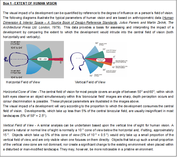
Boxes 1 and 2 below show
that for an individual fish farm, the horizontal field of view will be visually
dominant for distance <170 m and insignificant further than 2.3 km away, whereas the vertical field of view will
be visually evident for distance <70m and insignificant for distance >340
m. Therefore, the maximum distance which the fish farm is considered
insignificant will be at >2.3 km.
Having determined the Assessment Area
for the VIA, VSRs have been broadly identified within the visual envelope.
VSRs may include the people who would reside, work, play within, or travel
through the Assessment Area and be potentially under the impact of the proposed
Project.
Subsequently Vantage Points, or
Viewpoints (VPs), were selected. VPs are positions selected to represent some
potential VSRs from where the proposed Project can be viewed, and are selected
to help illustrate the visual change that would be brought about by the
proposed Project. The VPs have been selected to ensure that in combination
they give a good overall representation of how the Project will appear to
different types of VSRs, both near and far and at sea level as well as lower
and higher ground elevations.
Assessment of the sensitivity of VSRs is influenced by
a number of factors including the following:
n Type of VSR. VSRs are categorized
according to whether the viewer is at home, at work or school, at play or
leisure, or travelling (ranked by the major VSR types, as described below):
-
Occupational VSRs –
These VSRs are people working or in education in the area, who view the
proposed Project from their workplace or education centre. Visual amenity is
in general not considered a top priority within the average workplace and these
VSRs are considered to be relatively less sensitive than residential VSRs as
their view will have a less important, although still material, effect on their
perception of quality of life. The degree to which this applies to workers
depends on whether their location is industrial, retail or commercial. The
VSRs in industrial areas, such as factories, are generally considered to be the
least sensitive, due to the relatively low quality of their existing view in an
industrial area.
-
Recreational VSRs –
These VSRs are people engaging in recreational activities such as hikers on established
trails and footpaths, recreational fishers near the coast and outlying
islands. Sensitivity of these VSRs depends on duration of stay, nature of the
activity and how enclosed the location is.
-
Travelling VSRs – These
VSRs are people travelling on marine vessels. They have varying sensitivity
depending on the speed, nature and frequency of travel, but are generally
considered to be transitory to the area with less regard for the surrounding
views and with low sensitivity.
n Number of individuals (ranked as very
many, many, few or very few);
n Quality of existing view (ranked as
good, fair or poor);
n Availability of alternative views
(ranked as yes or no);
n Degree of visibility (ranked as full,
partial or glimpse);
n Duration of view (ranked as long, medium
or short); and
n Frequency of view (ranked as
frequent, occasional or rare).
The sensitivity of each VSR is based
on the values of all the above factors in totality and classified as follows:
n High: The VSR is highly
sensitive to any change in their viewing experience.
n Medium: The VSR is moderately sensitive to
any change in their viewing experience.
n Low: The VSR is only slightly
sensitive to any change in their viewing experience.
The magnitude of change caused by a visual impact is
quantified according to a number of factors including the following:
n Distance between the closest source
of impact and the VSR (given in meters);
n Scale of the development. This is
assessed using a number of factors, including: absolute dimensions of new built
structures visible to the VSR; relative dimensions of the new built structures
compared to other structures visible to the VSRs in their existing view (ranked
as small, medium or large);
n Potential blockage of view (ranked as
full, partial or nil);
n Duration of the impacts (ranked as
temporary or permanent);
n Compatibility of the Project and
associated works with the existing and planned landscape in the vicinity
(ranked as good, fair or poor); and
n Reversibility of change (ranked as
reversible or irreversible).
The magnitude of change caused by
visual impacts on each VSR is based on the values of all the above factors in
totality and classified as follows:
n Large: VSRs would suffer a major
change in their viewing experience.
n Intermediate: VSRs would suffer a
moderate change in their viewing experience.
n Small: VSRs would suffer a
small change in their viewing experience.
n Negligible: VSRs would suffer no
discernible change in their viewing experience.
By understanding the magnitude of
change caused by the various impacts and the sensitivity of the various
sensitive receivers, it is possible to categorize impacts in a logical,
well-reasoned and consistent fashion. Table 7.1 shows the
rationale for dividing the degree of significance into four thresholds, namely
insignificant, slight, moderate, and substantial, depending on the combination
of a magnitude of change and sensitivity of sensitive receiver.
Table 7.1 Relationship
between receptor sensitivity and magnitude of change in defining impact
significance
|
|
|
Magnitude of Change
|
|
|
|
Negligible
|
Small
|
Intermediate
|
Large
|
|
Receptor Sensitivity
(VSR)
|
Low
|
Insignificant
|
Slight
|
Slight / Moderate*
|
Moderate
|
|
Medium
|
Insignificant
|
Slight / Moderate*
|
Moderate
|
Moderate / Substantial*
|
|
High
|
Insignificant
|
Moderate
|
Moderate / Substantial*
|
Substantial
|
|
|
|
|
|
|
|
* In those instances where the lower level of impact
is predicted, this will be justified in the description of the impact
The four thresholds for
the degree of significance are explained below. Noting impacts can be either
adverse or beneficial, it should be noted that any impacts described in the
text of the Report are assumed to be adverse unless specifically identified
otherwise.
n Substantial: Adverse / beneficial
impact where the proposed Project will cause significant deterioration or
improvement in existing landscape quality.
n Moderate: Adverse / beneficial impact where
the proposed Project will cause a noticeable deterioration or improvement in
existing landscape quality.
n Slight: Adverse / beneficial impact where
the proposed Project will cause barely perceptible deterioration or improvement
in existing landscape quality.
n Insignificant: No discernible change in
the existing landscape quality
Having identified and ranked the
significance of potential impacts, measures, if required, will be proposed to
mitigate the impacts. Firstly, means by which impacts can be avoided will be
considered, then possible means that might reduce the impact magnitude, and
also measures that potentially enhance existing visual quality. To ensure their
effectiveness throughout the construction and operation phases of the Project
and associated works, the relevant responsible parties for the implementation
and management / maintenance of the proposed mitigation measures will be
identified as appropriate.
As outlined in Section 7.1,
the photomontages will illustrate options of design schemes as well as
mitigation measures by showing baseline conditions, Day 1 with no mitigation
measures, Day 1 with mitigation measures and Year 10 with mitigation measures.
An overall assessment of the
acceptability, or otherwise, of visual impacts in accordance with the five
criteria set out in Annex 10 of the EIAO-TM will be provided,
considering the guidelines in paragraph 3.11 of Environmental Impact Assessment
Ordinance GN No. 8/2010.
As detailed in Figure 7.1, Figure 7.3 and Figure 7.4, the indicative location
of the Project site is about 2 km northeast of Plover Cove Country Park and 1.8
km southeast of Yan Chau Tong Marine Park. The Project is located in a
relatively open sea area with high degree of visibility to a large area from a
visual perspective.
The Project site will be visible to east facing coastline of
Wong Chuk Kok Hoi, north facing coastline on Wong Wan Chau and elevated areas
of Plover Cove Country Park. Visitors and hikers at Plover Cove Country Park,
Yan Chau Tong Marine Park, and Wong Chuk Kok Hoi, and marine seafarers such as
ferry passengers and fishermen, will have view to the Project site (Figure 7.1).
Overall, the VSRs have been identified within the predicted
Visual Envelope, including three types as identified in the methodology:
recreational, occupational and travelling. The VSRs include receivers at
ground level, sea level and on elevated ground. The quality of most existing
views for these VSRs affected by the FCZ, are generally good, respectively,
with a high degree of visibility to natural views containing limited or no
anthropogenic structures. The details of VSRs are summarised in Table
7.2 which includes their sensitivity.
Table 7.2 VSRs within the Predicted Visual
Envelope
|
VSR ID /
Representative VP
|
Representative
VP
|
VSR Type
|
Distance
with the FCZ (m)
|
Quality
of Existing View
|
Alternative
Views
|
Receiver
Population
|
Duration
of View
|
Frequency
of View
|
Degree of
Visibility
|
Sensitivity
|
|
VSR 1 – Hikers / recreational
viewers from
elevated areas of Plover Cove
Country Park / Tolo Channel
(Northern Coast SSSI)
|
VP1
|
Recreational
|
3,140
|
Good
|
Yes
|
Few
|
Short
|
Occasional
|
Full
|
Medium
|
|
VSR 2 – Visitors at Yan Chau Tong
Marine Park and Hung Shek Mun
|
VP2
|
Recreational
|
1,810
|
Good
|
Yes
|
Few
|
Short
|
Occasional
|
Full
|
Medium
|
|
VSR 3a – Fishermen working /
travelling to Wong Wan FCZ
|
VP3
|
Occupational
|
944
|
Good
|
Yes
|
Few
|
Long
|
Frequent
|
Full
|
Medium
|
|
VSR 3b – Users of Outward Bound
Hong Kong
|
Recreational
|
Short
|
Occasional
|
Full
|
Medium
|
|
VSR 4 – Visitors / Seafarers at
Wong Chuk Kok Hoi and travelling to Northeastern waters in Hong Kong
|
VP4
|
Traveling
|
955
|
Good
|
Yes
|
Few
|
Short
|
Occasional
|
Full
|
Medium
|
As shown in Figure 7.1, computer modelling
suggests sections of coastal areas near Plover Cove
Country Park, Double Island fall within the visible area for the Project
site. Broad VSR areas and specific locations
of VPs are illustrated in Figure 7.1 and 7.3. It should be noted that Double
Island to the north of the Project site is not accessible by public transport
and there is no dedicated hiking trail on Double Island. Therefore, there is
no additional viewpoint identified to the north of the Project site. In
addition, the immediate southern part of the Project site is Plover Cove Country
Park, which is represented by VSR1 (i.e. hikers / recreational visitors from
elevated areas of Plover Cove Country Park / Tolo Channel). Therefore, there
is no additional viewpoint identified to the south of the Project site.
Generally VPs have been
selected to represent the most affected VSRs and a total of 4 nos. of VPs have
been selected from which to develop photomontages. Figure 7.1 and 7.3 show the suggested VP
locations and their corresponding details are provided below. Figure 7.4 shows the aerial photos of
the suggested VP locations. Figure 7.5a&b – 7.8a&b show the existing
conditions of VP1 – VP4.
VPs selected to represent
VSRs of the proposed Wong Chuk Kok Hoi FCZ
Views from Marine Park,
Country Park and Scenic Lookouts
VP1 – Viewpoint along
Plover Cove Country Park Trail. VP1 is selected to represent hikers from
elevated areas of Plover Cove Country Park. The selected VP is located at one
of the popular hiking trails in Wong Chuk Kok Hoi that provides a panoramic
view of the bay including the location of the proposed Wong Chuk Kok Hoi FCZ.
It is located
approximately 3,140 m southwest of the Project site. Table 7.2 shows
the value and quality of view of the sea from this VP is considered to be
good. This VSR has alternative views to the sea. The number of VSRs is few
due to the limited number of hikers visiting the country park. The duration
and frequency of view is short and occasional as this VSR only spends a limited
amount of time along the trail during holidays. This VSR has a full degree of
visibility with a high altitude. Therefore, VSR 1 is considered to have medium
sensitivity.
VP2 - Yan Chau Tong
Marine Park and Hung Shek Mun. VP2 is located within the Yan Chau Tong
Marine Park and in the vicinity of Hung Shek Mun. This VP is selected to
represent visitors that will travel within the marine park and near the Hung
Shek Mun coastline dominated by red sedimentary rocks. It is located approximately
1,810 m west of the Project site. Table 7.2 shows the value and
quality of view of the sea from this VP is considered to be good. This VSR has
alternative views to the sea. The number of VSRs is few due to the limited number
of tourists visiting Yan Chau Tong Marine Park and Hung Shek Mun. The duration
and frequency of view is short and occasional as this VSR only spends a limited
amount of time along the trail during holidays. This VSR has a full degree of
visibility. Therefore, VSR 2 is considered to have medium sensitivity.
Views from Other FCZ and Marine
Waters
VP3 – Wong Wan FCZ and
areas in vicinity. VP3 is selected to represent fishermen travelling
to or working at the Wong Wan FCZ (VSR 3a) and users of Outward Bound Hong Kong
(VSR 3b). Water sports, such as kayaking are common at waters around Outward
Bound Hong Kong and the nearby coastal area. It is located approximately 944 m west of the
Project site. Table 7.2 shows the value and quality of view of
the sea from this VP is considered to be good. Both VSRs have alternative
views to the sea. The number of both VSRs is few due to the limited number of
fishermen travelling to or working at the Wong Wan, and users of Outward Bound
Hong Kong. Both VSR have a full degree of visibility. For fishermen
travelling to or working at the Wong Wan FCZ (VSR 3a), although they have long and
frequent view of the Project, they are occupational VSR, who would mainly focus
much on work, hence having medium sensitivity. For users of Outward Bound Hong
Kong (VSR 3b), although they have short and occasional view of the Project,
they are recreational VSR, who aim to enjoy the view, hence having medium
sensitivity.
VP4 – Wong Chuk Kok Hoi
Waters. VP4 is selected to represent viewers on the sea (e.g.
recreational vessels, fishermen) travelling between Wong Chuk Kok Hoi and Hung
Shek Mun, and when visiting the Yan Chau Tong Marine Park. It is located
approximately 955
m
northeast of the Project site. Table 7.2 shows the value and quality
of view of the sea from this VP is considered to be good. This VSR has
alternative views to the sea. The number of VSRs is few due to the limited
number of visitors and seafarers at Wong Chuk Kok Hoi and travelling to Northeastern. The
duration and frequency of view is short and occasional. This VSR has a full
degree of visibility. Therefore, VSR 4 is considered to have medium
sensitivity.
Section 2 provides an overview of
the Project. The key components which may cause visual impacts are listed
below. Construction visual impacts are expected to be minimal and may be
caused by:
n Setup of fish rafts / cages, which
includes: on-site assembly and anchoring of the fish rafts/ cages, small number
of marine vessels will be used as supporting vessels; and
n Provision of auxiliary facilities,
such as storage and shelters for fish farmers.
Operational visual impacts are
expected to be minimal and arise from:
n The presence and operation of the
FCZ, including night time lighting for the sake of safety purpose.
The construction of the Project site,
including towing the fish rafts / cages to the Site, assembly and anchoring of
the fish rafts / cages and provision of auxiliary facilities would normally
take a few weeks for each fish raft.
During operation phase, as mentioned in Section 2.6.2,
four types of advanced aquaculture technologies, i.e. floating gravity cage;
submersible gravity cage; integrated multi-trophic aquaculture; and
semi-submersible steel truss cage, are considered suitable for this Project. Since the materials
adopted in the fish rafts / cages are durable compared to traditional cages,
the operation of the fish rafts / cages in the Project site based on advanced
aquaculture technologies would be more than 10 years without major repair.
As illustrated in Figures 7.1, 7.3 and 7.4, the predicted Visual
Envelope for the Project is relatively large and the VSR groups have been
identified. Four representative VPs have been selected to represent these
VSRs.
Photomontages have been prepared from
the VPs to illustrate the existing conditions, as well as conceptual visual
impacts, for all of: impacts at Day 1 of operation without implementation of
mitigation / enhancement measures; impacts at Day 1 of operation with
implementation of mitigation / enhancement measures and residual impacts at
Year 10 of operation with implementation of mitigation / enhancement measures.
The photomontages supplement the visual changes described in the text. Photomontages
showing the presence of the FCZ help illustrate that the magnitude of visual
change for all VSRs are negligible to intermediate. Those VSRs that are closer
to the FCZ are expected to experience relatively higher magnitude of change. It should be noted that detailed information on the type
of advanced
aquaculture technologies as well as the number, size and separation distance
of the fish rafts / cages is not available at the current stage. Such
information will only be available during the later detailed design stage,
subject to the mariculturists’ proposals on the type of advanced technologies
to suit their business need for agreement with AFCD. The photomontages are
thus prepared for illustration purpose only.
The construction of the Project will
take a few weeks for each fish raft. Despite the considerable distance to the
Project (3,140 m), since the viewpoint is at a high altitude, the construction
activities will be noticeable, and the magnitude of change is considered
small. The resulting significance during construction is considered slight.
The photomontage in Figure 7.5a&b shows the Project site
from this viewpoint. Since the FCZ facilities will not be higher than 3 m in
height above water (except during maintenance), only the upper part of the fish
rafts / cages would be exposed above the water, they would only block part of
the view, and the scale of development is small. As the fish rafts / cages
will be noticeable on the open water, they have fair compatibility with the
surrounding seascape. The duration of impact is temporary during construction
phase and permanent during operation phase; and the impact is reversible for
both phases. Despite the considerable distance to the Project (3,140 m), since
the viewpoint is at a high altitude, the magnitude of change is considered
small. The resulting significance during operation is considered slight.
The construction of the Project will
take a few weeks for each fish raft. Due to the considerable distance (1,810
m) to the Project, the construction activities will not be noticeable, and the
magnitude of change is considered negligible. The resulting significance during
construction is considered insignificant.
The photomontage in Figure 7.6a&b shows the Project site
from this viewpoint. Since the FCZ facilities will not be higher than 3 m in
height above water (except during maintenance), only the upper part of the fish
rafts / cages would be exposed above the water, and the scale of development is
small. As the fish rafts / cages will be noticeable on the open water, they
have fair compatibility with the surrounding seascape. The duration of impact
is temporary during construction phase and permanent during operation phase;
and the impact is reversible for both phases. Given there is a considerable
distance to the Project (1,810 m), the viewpoint is horizontal to WCKH, and the
FCZ facilities’ above water heights are limited to 3 m (except during
maintenance), the magnitude of change is considered negligible. The resulting
significance during operation is considered insignificant.
The construction of the Project will
take a few weeks for each fish raft. Despite the short distance (944 m) to the
Project, since the viewpoint is horizontal to WCKH and the construction
activities will not be noticeable, and the magnitude of change is considered
negligible. For fishermen working / travelling to Wong Wan FCZ (VSR 3a),
although they have long and frequent view of the Project, they are occupational
VSR, who would mainly focus much on work, hence having medium sensitivity. For
users of Outward Bound Hong Kong (VSR 3b), although they have short and
occasional view of the Project, they are recreational VSR, who aim to enjoy the
view, hence having medium sensitivity. Therefore, the resulting significance
during construction is considered insignificant for both VSRs.
The photomontage in Figure 7.7a&b shows the Project site
from this viewpoint. Since the FCZ facilities above water will not be higher
than 3 m in height (except during maintenance), only the upper part of the fish
rafts / cages would be exposed above the water, and the scale of development is
small. As the fish rafts / cages will be noticeable on the open water, they
have fair compatibility with the surrounding seascape. The duration of impact
is temporary during construction phase and permanent during operation phase;
and the impact is reversible for both phases. Despite the short distance to the
Project (944 m), since the viewpoint is horizontal to WCKH, and the FCZ
facilities’ above water heights are limited to 3 m (except during maintenance),
the magnitude of change is considered negligible. As suggested in the previous
section, fishermen working / travelling to Wong Wan FCZ and users of Outward
Bound Hong Kong are considered to have medium sensitivity. Therefore, the
resulting significance during operation is considered insignificant for both
VSRs.
The construction of the Project will
take a few weeks for each fish raft. However, due to the short distance (955
m) to the Project, the construction activities will be noticeable, and the
magnitude of change is considered small. The resulting significance during
construction is considered slight.
The photomontage in Figure 7.8a&b shows the Project site
from this viewpoint. Since the FCZ facilities will not be higher than 3 m in
height above water (except during maintenance), only the upper part of the fish
rafts / cages would be exposed above the water, they would only block part of
the view, and the scale of development is small. As the fish rafts / cages
will be noticeable on the open water, they have fair compatibility with the
surrounding seascape. The duration of impact is temporary during construction
phase and permanent during operation phase; and the impact is reversible for
both phases. Due to the short distance to the Project (955 m), the magnitude
of change is considered slight. The resulting significance during operation is
considered small.
Table 7.3 details magnitude of
change expected for each VSR. Based on the magnitude of change and the
baseline sensitivities given to each VSR, a summary of the visual impacts prior
to mitigation is provided in Table 7.4 and impacts are considered
to be adverse and acceptable unless stated otherwise.
Table 7.3 Magnitude of Change
|
VSR ID /
Representative VP
|
Representative
VP
|
Distance
with the FCZ (m)
|
Blockage
of View (Full / Partial / Nil)
|
Scale of
Development (Large / Medium / Small)
|
Compatibility
with Surrounding Seascape (Good / Fair / Poor)
|
Duration
of Impact (Temporary / Permanent)
|
Reversibility
of Impact (Reversible / Irreversible)
|
Magnitude
of Change
(Large /
Intermediate / Small / Negligible)
|
|
Construction
|
Operation
|
|
VSR 1 – Hikers / recreational
viewers from elevated areas of Plover Cove Country Park / Tolo Channel
(Northern Coast SSSI)
|
VP1
|
3,140
|
Partial
|
Small
|
Fair
|
Construction phase:
Temporary;
Operation phase: Permanent
|
Reversible for both construction
and operation phases
|
Small
|
Small
|
|
VSR 2 – Visitors at Yan Chau Tong
Marine Park and Hung Shek Mun
|
VP2
|
1,810
|
Partial
|
Small
|
Fair
|
Construction phase:
Temporary;
Operation phase: Permanent
|
Reversible for both construction
and operation phases
|
Negligible
|
Negligible
|
|
VSR 3a – Fishermen working /
travelling to
Wong Wan Chau FCZ
|
VP3
|
944
|
Partial
|
Small
|
Fair
|
Construction phase:
Temporary;
Operation phase: Permanent
|
Reversible for both construction
and operation phases
|
Negligible
|
Negligible
|
|
VSR 3b – Users
of Outward Bound Hong Kong
|
|
VSR 4 – Visitors / Seafarers at
Wong Chuk Kok Hoi and travelling to Northeastern waters in Hong Kong
|
VP4
|
955
|
Partial
|
Small
|
Fair
|
Construction phase:
Temporary;
Operation phase: Permanent
|
Reversible for both construction
and operation phases
|
Small
|
Small
|
Table 7.4 Visual Impacts Prior to Mitigation
|
VSR ID /
Representative VP
|
Representative VP
|
VSR Sensitivity
|
Magnitude of Change
(Large /
Intermediate / Small / Negligible)
|
Impact Significance
threshold BEFORE Mitigation
(Substantial/
Moderate/ Slight/ Insignificant)
|
|
Construction
|
Operation
|
Construction
|
Operation
|
|
VSR 1 – Hikers / recreational
viewers from elevated areas of Plover Cove
Country Park / Tolo Channel
(Northern Coast SSSI)
|
VP1
|
Medium
|
Small
|
Small
|
Slight
|
Slight
|
|
VSR 2 – Visitors at Yan Chau Tong
Marine Park and Hung Shek Mun
|
VP2
|
Medium
|
Negligible
|
Negligible
|
Insignificant
|
Insignificant
|
|
VSR 3a – Fishermen working /
travelling to Wong Wan FCZ
|
VP3
|
Medium
|
Negligible
|
Negligible
|
Insignificant
|
Insignificant
|
|
VSR 3b – Users of Outward Bound
Hong Kong
|
Medium
|
Negligible
|
Negligible
|
Insignificant
|
Insignificant
|
|
VSR 4 – Visitors / Seafarers at
Wong Chuk Kok Hoi and travelling to Northeastern waters in Hong Kong
|
VP4
|
Medium
|
Small
|
Small
|
Slight
|
Slight
|
The above analysis examined the
visual impacts of the Project during daylight hours. Night-lighting will be
used for safety purpose in this Project. Detailed night lighting
specifications are not available at this preliminary design stage, however, a
preliminary assessment can be made based on similar developments. It is assumed
that the light sources will generally be of low intensity, the orientation of
light will point towards to the fish rafts / cages, and will not be pointing
horizontally and to any VSRs. In addition, no mirrors or polished materials
will be installed on the fish rafts / cages, reflectance of light will be low.
Therefore, the night lighting and glare impact is considered acceptable.
The assessment made in Section
7.8 shows that visual impacts arising from the Project without any
mitigation or enhancement measures in place are between insignificant to
slight. The following mitigation measures are proposed to minimise the visual
impacts:
n VM1 – Construction period. Pre-construction and
construction period for the Project site should be reduced as far as practical
to lower visual impact;
n VM2 – Sensitive design of the fish
rafts / cages. The new structures will be designed in accordance with relevant marine
safety standards and regulations. Sensitive architectural design will be
considered where practicable. This should take into account material texture,
colour, finishes to structures to ensure the fish rafts/ cages blend into the
existing context, cause least disturbance to the existing seascape, and are the
most visually appealing. Please refer to Figure 7.5b, Figure 7.6b, Figure 7.7b and Figure 7.8b for the
implementation of VM2;
n VM3 – Reinstatement. After operation, the
open water occupied by the Project site will be reinstated to their former
state, i.e. the ‘existing view’ (top photo) shown in Figure 7.5a, Figure 7.6a, Figure 7.7a and Figure 7.8a;
n VM4 – Night-time lighting control. Light intensity and
beam directional angle should be controlled at the Project site at the design
stage to reduce light pollution and glare (e.g. hooded lights, specific
directional focus, etc.). In addition, lighting will be limited to auxiliary
structures to reduce night-time impacts.
Table 7.5 Un-mitigated and Mitigated Impacts
at the VSRs
|
VSR ID /
Representative VP
|
Un-Mitigated Visual
Impact
|
Recommended
Mitigation Measure
|
Mitigated Impact
(Substantial/ Moderate/ Slight/ Insignificant)
|
|
Construction
|
Operation
|
|
Construction
|
Operation Day 1
|
Operation Year 10
|
|
VSR 1 – Hikers / recreational
viewers from elevated areas of Plover Cove
Country Park / Tolo Channel
(Northern Coast SSSI)
|
Slight
|
Slight
|
VM1-4
|
Insignificant
|
Insignificant
|
Insignificant
|
|
VSR 2 – Visitors at Yan Chau Tong
Marine Park and Hung Shek Mun
|
Insignificant
|
Insignificant
|
VM1-4
|
Insignificant
|
Insignificant
|
Insignificant
|
|
VSR 3a – Fishermen working /
travelling to Wong Wan FCZ
|
Insignificant
|
Insignificant
|
VM1-4
|
Insignificant
|
Insignificant
|
Insignificant
|
|
VSR 3b – Users of Outward Bound
Hong Kong
|
Insignificant
|
Insignificant
|
VM1-4
|
Insignificant
|
Insignificant
|
Insignificant
|
|
VSR 4 – Visitors / Seafarers at
Wong Chuk Kok Hoi and travelling to Northeastern
waters in Hong Kong
|
Slight
|
Slight
|
VM1-4
|
Insignificant
|
Insignificant
|
Insignificant
|
The assessment made in Section
7.7 shows that visual impacts arising from the Project prior to any
mitigation or enhancement measures in place, are between insignificant to
slight.
By operation, auxiliary facilities
will have been removed. Therefore with sensitive design of the new structures
(materials, textures, colours) and careful design of lighting, impacts would
further reduce at operation day 1 for the Project site. The new structures are
expected to blend in to the seascape and residual visual impacts will be
insignificant to VSR 1, VSR 2, VSR 3a, VSR 3b and VSR 4.
No unacceptable residual visual
impact is expected.
No existing or committed project is
identified in the vicinity of the Project site. The Project may have the
potential to interact with the proposed establishment of FCZs at Outer Tap Mun
and Mirs Bay, subject to the timing of completion of legislative exercise to
amend the Schedule to the Fish Culture Zone (Designation) Order (Cap. 353B).
Due to its considerable distance with Outer Tap Mun (~3.9 km) and Mirs Bay
(~6.3 km), cumulative impacts are not expected from these projects.
A number of measures to be
implemented during design and construction of the Project are recommended in Section
7.9, to further enhance the visual elements associated with the
Project. Design measures such as for the design of the new fish rafts / cages
are recommended to be integrated into the design and construction stage of the
Project as early as possible.
As no tree felling, transplanting or
compensatory planting is required for the Project and visual enhancement
measures would be provided during the construction phase, therefore no specific
EM&A programme is required.
A visual impact assessment has been
undertaken for the Project located at Wong Chuk Kok Hoi. The VSRs were
identified and assessed based on their sensitivity and magnitude of change.
Four visual mitigation measures are proposed to minimise the visual impacts.
Given the sensitive design of the new structures, small scale of development
and good compatibility with the surrounding seascape of the structures,
residual visual impacts of the Project will be subsequently considered
insignificant. No unacceptable residual visual impact is expected.
Cumulative visual impacts are not
anticipated to be additional to the visual impacts of proposed establishment of
FCZs at Outer Tap Mun and Mirs Bay.
According to Annex 10 of the Technical
Memorandum on the Environmental Impact Assessment Process (EIAO-TM)
the visual impacts are considered acceptable with mitigation measures.
