An existing twin 400mm diameter submarine gas pipelines across the Victoria Harbour were constructed by Hong Kong China Gas Company Limited in the early 1970s to supply town gas from Kowloon to the Hong Kong Island. The existing twin 400mm diameter submarine gas pipelines are currently aligned 200m west of and parallel to the Former Kai Tak Airport (KTA) runway between a gas offtake and pigging station at the existing seawall at Ma Tau Kok (MTK) and a gas pigging station at North Point (NP). The submarine gas pipelines are buried in a trench beneath the seabed and protected with rockfill. Owing to the proposed Cruise Terminal Development (CTD) and Central Kowloon Route (CKR) projects, the existing twin 400mm diameter submarine gas pipelines were requested to be diverted.
Mott MacDonald Hong Kong Ltd. was appointed
by the
The Project comprises construction of a new
gas pipeline network from To Kwa Wan to North Point so as to replace the existing
one affected by the proposed Cruise Terminal dredging works adjacent to the
existing Kai Tak runway and the proposed
The Project will ensure that the replacement of the existing gas facilities from To Kwa Wan to North Point are completed in 2014 and the new facilities are in service before the de-commissioning of the existing facilities.
The Project commenced with the
identification of key issues and constraints within the Study Area. The
engineering constraints at the
The harbour area concerned is currently the To Kwa Wan Typhoon Shelter, government mooring area, Eastern Fairway and the Eastern Quarantine and Immigration Anchorage Area.
The landfall site at To Kwa Wan will be on previously reclaimed land. The pipeline at To Kwa Wan will run through part of the previously reclaimed land after landing. The use of landing point at To Kwa Wan has been zoned as other specific used (“OU”) according to the latest information from Planning Department.
The landfall site at North Point will be on
previously reclaimed land. The pipeline at North Point will connect to existing
gas pipeline at
The scope of the proposed Project comprises the following:
¡
twin submarine gas pipelines across the
¡ two land gas pipelines at To Kwa Wan and North Point respectively (non designated project under EIA Ordinance); and
¡ two pigging stations for pigging operation at To Kwa Wan and North Point respectively (non designated project under EIA Ordinance).
The “submarine gas pipeline” component of
the Project is classified as Designated Project under item H.2 of Part I of
Schedule 2 of the Environmental Impact Assessment Ordinance (EIAO) (Cap. 499). The
dredging operation associated with the formation of trench for installation of
submarine gas pipelines is classified as Designated Project under item C.12 (b)
of Part I of Schedule 2 of the Environmental Impact Assessment Ordinance (Cap.
499) as it is less than 100m from a seawater intake point. An Environmental Permit (EP) issued under the EIAO is
required for the construction and operation of the designated project. An
application for an EIA study brief under section 5(1) of the EIAO was submitted
by the
As the proposed To Kwa Wan pigging station is located within an area zoned “Other Specified Uses” annotated “Sewage Treatment Plant”(“OU(STP)”) on the Draft Hung Hom Outline Zoning Plan (OZP) No. S/K9/23, planning permission from the Town Planning Board under Section 16 of the Town Planning Ordinance had been applied according to the Notes of the OZP as utility installation not ancillary to the specified use in “OU(STP)” zone requires planning permission.
As the proposed North Point pigging station is located within an area zoned “G/IC” and “Road” on the North Point OZP, planning permission from the Town Planning Board under Section 16 of the Town Planning Ordinance had been applied according to items 7 and 8 of the Notes of OZP as the proposed North Point pigging station in Road zone requires planning permission.
Approval of the Section 16 Applications for the two pigging stations from Town Planning Board were granted on 19 March 2010. Assessment of environmental impact for the pigging stations were incorporated in the approved planning permission applications for the two pigging stations prepared under Section 16 of the Town Planning Ordinance and therefore are not covered in details in the EIA report.
The decommissioning/ removal works of the existing cross-harbour submarine pipelines and gas pigging stations are not included in the scope of the proposed Project.
2.4 Relationship between the existing cross-harbour gas pipelines and pigging stations and the proposed gas pipelines and pigging stations
As part of the Kai Tak Development (KTD) as shown in Figure 2.1, a Cruise Terminal is proposed to be constructed at the southern end of the former KTA runway. For the provision of the safe berthing and manoeuvring of the vessels at the Cruise Terminal, the foreshore and seabed at the southern side of the former KTA runway would generally be dredged down to about 12m below Hong Kong Chart Datum, with the berthing area of about 50m wide adjoining the edge structures of the Cruise Terminal to be dredged further down to about -13mPD below Hong Kong Chart Datum and surfaced with scour protection layer. The second berth of Cruise Terminal will be ready for berthing medium-sized cruise vessels in 2014. After relocation of the submarine gas mains, the second berth will be able to accommodate mega cruise vessels in 2015/2016.
The proposed Central Kowloon Route (CKR) as
shown in Figure 2.1
would connect West Kowloon with the proposed SEKD Development and the road
network in
As the proposed Cruise Terminal dredging works adjacent to the existing Kai Tak runway and Central Kowloon Route crossing Kowloon Bay at Ma Tau Kok would have conflict with the existing twin 400mm diameter steel submarine gas pipelines aligned 200m west of and parallel to the Former Kai Tak Airport (KTA) runway, at the request of the HKSAR Government, the existing submarine gas pipelines together with the pigging stations at To Kwa Wan and North Point needs to be relocated to facilitate the above two projects. Prior to the abandonment of existing submarine gas pipelines in which decommissioning would take place in 2014, installation of new submarine gas pipelines and construction of new gas pigging stations are required to maintain the supply of town gas to the Hong Kong Island.
The existing twin
400mm dia. submarine gas pipelines from Ma Tau Kok to North Point were laid
below the existing seabed. They were crucial for the supply of town gas to the
2.6 Consideration of Alternative Alignment Options
Eight
options were considered for the proposed submarine gas pipelines across the
The selection of the proposed submarine gas pipelines alignment is subject to many constraints.
Firstly, conflict with the major installations and underground structures within the study area which are considered to be physical constraints to the alignment of the proposed submarine gas pipelines have to be avoided. These include:
¡ To Kwa Wan and Kwun Tong Typhoon Shelters;
¡ Small Craft Mooring Buoys;
¡ Government Mooring Buoys;
¡
Eastern Quarantine and Immigration
¡ Hung Hom and Eastern Fairways;
¡ To Kwa Wan, North Point and Kwun Tong Sewage Outfall; and
¡ Island Eastern Corridor.
Secondly, the potential environmental impacts of the project should be avoided or minimised. These include impacts to water quality, sediment management, coral communities and marine archaeology.
The
landing points of the submarine gas pipelines should avoid foundations/pier
structures of the Island Eastern Corridor and utilities and infrastructure
along the coast of
The
submarine gas pipelines are proposed to be laid across the
As shown in Figure 2.1, the proposed submarine gas pipelines are bounded by To Kwa Wan and North Point Sewage Outfall and the Eastern Quarantine and Immigration Anchorage. The existing To Kwa Wan Typhoon Shelter, sewage outfall for To Kwa Wan Sewage Treatment Works, seawater intake for Quarry Bay Salt Water Pumping Station, foundations/pier structures of Island Eastern Corridor while the proposed pigging stations and land gas pipelines are bounded by proposed extension of To Kwa Wan Sewage Treatment Works and proposed extension of Man Hong Street Playground. Horizontal alignment of the proposed submarine gas pipelines is shown in Figure 2.3. Location and layout plans, sections and elevations with dimensions in appropriate scales of the proposed To Kwa Wan and North Point pigging stations are shown in Figures 2.9 to 2.12.
By considering the constraints discussed above, the most feasible submarine gas pipelines alignment and landing points are as follows:
For the submarine portion, the shortest and the most feasible route for this portion is an alignment between the dictated landing points at the open space near Hoi Shum Park and at the waterfront area next to North Point Police Station in a manner as shown in Figure 2.1 such that the impact on water quality, coral communities, sediment management and marine archaeology be minimized and impact on underwater infrastructure and marine traffic is minimal.
For To Kwa Wan, the most feasible landing point is at the area to the north of existing DSD To Kwa Wan Sewage Treatment Works and then connected to a new pigging station located at adjacent to the future Hoi Sam Park extension close to the existing Sewage Treatment Plant.
For North Point, the most feasible landing point inside the North Point Police Station and then connected to a new pigging station located at the same area.
2.7 Consideration of Alternative Pigging Stations Locations/Designs
2.7.1 Locating the pigging station wholly or partly underground
An
underground or recessed design of pigging station could possibly mitigate
operation phase landscape impacts and release more space on ground level for
enjoyment of the public. However, an underground pigging station would pose
additional and thus undue risk to the public, by virtue of entailing a confined
space which facilitates the accumulation of any explosive gas as well as
additional equipment that is subject to failure. An underground design of pigging
station would require cut and cover construction of a large confined space to
house a large underground plant room which would lead to dust, noise and landscape
impacts on the sensitive receivers during construction phase. Due to the
increase in risk and from the gas safety point of view, the underground design
of pigging station is not acceptable. Apart from an increase in risk, the
reliability of the gas supply to the entire
Similarly, a recessed pigging station (the top of the station is covered by removable gratings so that a ventilated environment could be maintained) could also possibly mitigate landscape impacts. However, any gas release may pass through the ground level which would pose undue risk to the persons on the top of the recessed station. On the other hand, the persons on the top of the recessed station would be a potential threat to the station itself as they can introduce ignition sources such as cigarette butts to the station easily. A recessed design of pigging station would require cut and cover construction of a large space to house a large underground plant room which would lead to dust, noise and visual disturbance on the sensitive receivers during construction phase. The issue on flooding is more serious than an underground pigging station as the grating would not detain any surface or rainwater from going into the recessed pigging station. The reliability of gas supply is affected due to the increased risk of flooding and accidental damage by persons on top of the pigging station. The recessed design of pigging station is therefore unacceptable.
2.7.2 Locating the pigging station outside the existing/planned “Open Space” zones as shown on the concerned Outline Zoning Plan
2.7.2.1 Proposed To Kwa Wan Pigging Station
Thirteen
options were considered for the selection of site on the
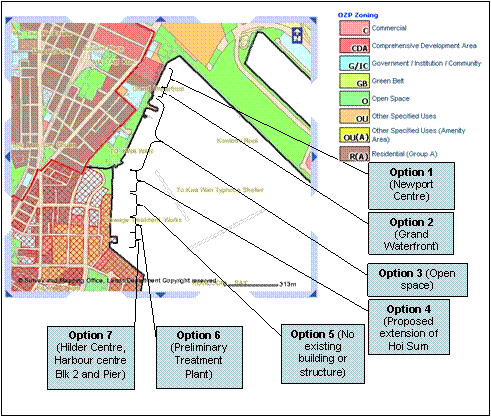
Figure 2.5 To Kwa Wan Pigging Station Options 1 to 7
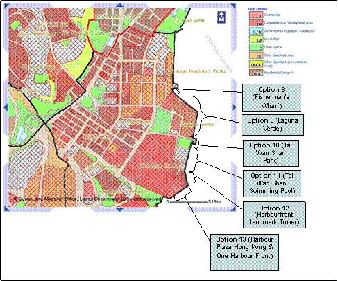
Figure 2.6 To Kwa Wan Pigging Station Options 8 to13
The selection of site for the To Kwa Wan pigging station is subject to many constraints. Firstly, Hung Hom and To Kwa Wan areas are mostly developed, a lot of existing buildings were constructed in the concerned area (Options 1, 2, 6, 7, 8, 9, 11, 12 and 13). Secondly, the proposed pigging station site should avoid encroach on existing or proposed “Open Space” as classified in the Outline Zoning Plan (Options 3, 4, 5 and 10), for example, King Wan Street Park, Land next to the Vehicle Inspection Centre, Area for Hoi Sam Park Extension. Finally, the only feasible site identified for the construction of To Kwa Wan pigging station was the site adjacent to the existing Preliminary Treatment Plant (Option 5) which is classified as “Other Specified Use (OU)” while the others are all zoned “Open Space” or occupied by existing buildings. As the proposed To Kwa Wan pigging station does not require substantial site formation works and demolition of existing buildings, it’s environmental nuisance (e.g. dust, noise and landscape impact) to the general public would be minimized during construction and operation stage of the pigging station. A waterfront promenade of at least 25m wide would be available next to the proposed To Kwa Wan pigging station.
2.7.2.2 Proposed North Point Pigging Station
Seventeen options were considered for the
selection of site on the
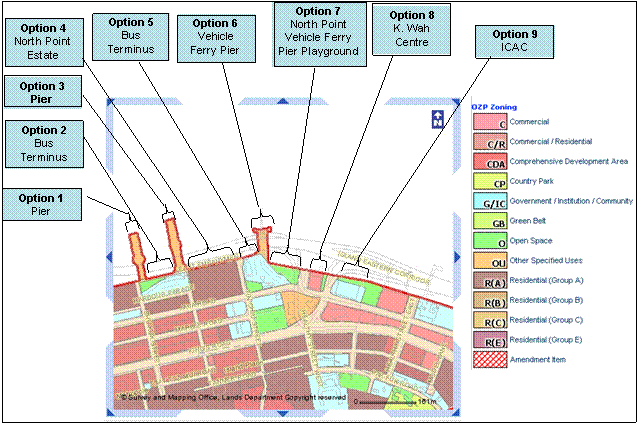
Figure 2.7 North Point Pigging Stations (Options 1-9)
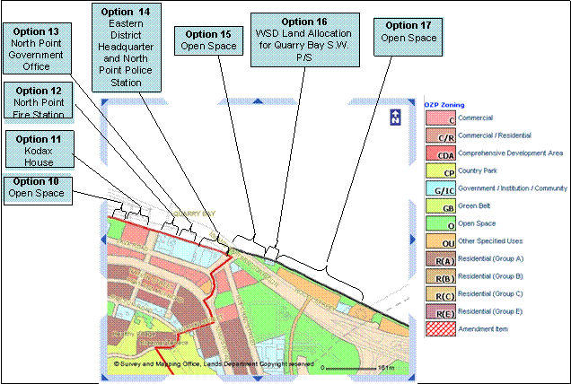
Figure 2.8 North Point Pigging Station (Options 10-17)
The
selection of site for the North Point pigging station is subject to lots of
constraints along the coastal area of
2.7.3 Connection to and expansion of the existing pigging station in the vicinity
2.7.3.1 Existing Ma Tau Kok Pigging Station
In
order to maintain the gas supply to the
As
there is no vacant land inside the existing pigging station for the
construction of a new pigging station, re-use of the existing pigging station requires
modification of the existing pigging station which would involve construction
works inside the existing pigging station for connection of new gas pipelines
to the existing gas pipelines. However, these modification/connection works
inside the existing pigging station might involve ground excavation, welding
of gas pipes and lifting of heavy materials in the vicinity of live gas
pipelines. It may pose safety hazards causing disruption to the existing gas
facilities and impose risk for affecting the town gas supply to the
In
addition, the proposed immersed tube tunnel in the
In view of the above, it is considered not feasible to reuse the existing pigging station.
2.7.3.2 Existing North Point Pigging Station
There
is an existing pigging station inside the North Point Police Station (NPPS)
compound and it has been operating for years. Re-use of the existing pigging
station could possibly minimise dust, noise and waste impacts on the sensitive
receivers during construction phase. Re-use of the existing NP pigging would
involve construction works inside the existing pigging station such as
connection of new gas pipelines to the existing gas pipelines. As
there is no vacant land inside the existing NP pigging station for the
construction of new pigging station, modification of the existing NP pigging
station would be required. However,
these modification works, which may involve ground excavation, welding
of gas pipes and lifting of heavy materials in the vicinity of live gas
pipelines, may cause disruption to the existing gas facilities
and impose risk for affecting the town gas supply to the
2.8 Consideration of Alternative Construction Methods
The methods commonly used to install submarine gas pipelines include “jetting (Trenching)”, “jetting (injection)”, “horizontal directional drilling”, and dredging to form the trench followed by “float and sink”, “bottom pull” or “lay barge” followed by backfilling to protect the pipeline. For this project the jetting technique is not feasible as described in Section 2.8.1.
Jetting installation involves the use of water jets to loosen the seabed material sufficiently to allow the pipe to be pulled into the seabed with significant disturbance to the seabed. Horizontal directional drilling involves taking the pipelines directly from the start to end point by underground drilling with no surface disturbance being necessary. Dredging involves the removal of marine sediments from the seabed to form the trench, into which the submarine gas pipelines are laid by possible methods including Bottom Pull, Lay Barge or the Float and Sink Method. Backfill material would be placed on top to protect the pipeline and minimize the cross section of dredging and backfilling works. A typical cross section of the submarine gas pipelines is provided in Figure 2.2. Design of the cross section and the resulting amount of marine sediments to be dredged from the seabed to form the trench will be depending on the required minimum cover as described in Section 2.8.3 and the existing seabed level for the Bottom Pull, Lay Barge or the Float and Sink Method adopted for submarine gas pipelines installation.
An analysis of different construction methods and techniques to minimise impacts on water quality, marine ecology, fisheries and waste was carried out. Details of the analysis are presented below.
2.8.1 Jetting Installation
2.8.1.1 Jetting (Trenching)
Jetting involves the uses of pressurized water jets to break-up, remove or liquefy the soil from under the submarine pipeline and allow it to settle at the design level below the seabed. Jetting is a technique by which the pipeline is pre-installed (laid) on the seabed before jetting is carried out.
The
jet machine ejects plumes of fluidised soil out of the eductors on the sides of
the machine in the bottom portion of the water column.
Based on the
ground investigation and laboratory testing data, the seabed material within
the works area of the project consist of about 30% of contaminated sediment. As
the contamination level of the
sediment along the dredging area at Victoria Harbour was high in terms of heavy metals such as Cu, Ni, Zn, Pb, Hg and high molecular weight Polycyclic Aromatic Hydrocarbons (PAHs) in which contaminated sediment (Type 3) was located near the To Kwa Wan
Typhoon Shelters and contaminated sediment (Type 2) was located near both
proposed pigging stations at North Point and To Kwa Wan which is extended up to
about the middle of proposed gas pipelines in Victoria Harbour. Based on the
ground investigation the sediment
immediately below the seabed comprises mostly very soft slurry deposit which are soft,
fine, dark grey and black, clay/silt (contaminated marine deposit), the
disturbance to the contaminated marine sediment must be minimized. Jetting is not feasible for such marine
sediment properties under the seabed. The jet machine would eject plumes of
fluidised soft fine slurry, clay and silt out of the sides of the machine and these
plumes of fluidised marine sediment would become entrained in the water column along
the tidal flow and cause adverse impacts on water quality and ecological
sensitive receivers in the vicinity.
The identified very soft clay would require a slope gradient of about 1 in 3 on the sides of the trench for stability. Additional and repeated passes would be required to achieve the required trench width and depths. This would increase the volume of contaminated marine sediment being ploughed up and thus increase the spread of highly contaminated substances. This also indicates that the jetting method would not be effective in the soft mud and slurry ground conditions. Furthermore, the contaminated slurry on the sides of the trench at the top layer of the seabed would tend to collapse into the trench formed by jetting with steep gradient and the required armour rock protection cover cannot be achieved accordingly.
The jetting method
would result in extensive pollution in heavily contaminated ground. The jetting
force would cause transportation/movement of contaminated sediment and fine
particle of contaminants from its original locations to other parts of the
2.8.1.2 Jetting (Injection)
The jetting injection method is similar to the jet trenching in that it is a post lay technique. The difference is that the marine sediments are not excavated from the trench once they are fluidised. Instead the jetting machine comprises two swords to cut into the marine sediments and then fluidise the marine sediments in front of the machine and between the two swords. The pipelines are positioned between the two swords and settle down into the space of the fluidised marine sediment. This technique may require more than three passes to lay the pipelines at the required depth of 3m. The practicality and environment impacts of jetting (injection) are similar to the Jetting (Trenching) method as described above.
2.8.2 Horizontal Directional Drilling
Horizontal Directional Drilling (HDD) is a method which takes the pipeline directly from start to end point by underground drilling with no surface disturbance being necessary. A pilot hole will be drilled with fluid pumping down the drill pipes for lubricating and stabilising the walls of the drillhole. After the full length pilot hole is complete, the drill is replaced with a reamer which is pulled back or pushed forward in several passes to enlarge the pilot hole to the required size. On completion of reaming, lengths of pipe are joined and pulled from one side of the landing point to the other using a bonded pull. Finally, the gap between the enlarged hole and the pipe string is grouted for fixing the pipe in position.
The potential for impacts to water quality from HDD is lower than dredging as sediments on the seabed would not be disturbed. However, the drilling fluid would require treatment prior to discharge. As the risk and difficulty for recovery in the event of jamming is considered to be very high, a large temporary workspace is required for setting up a horizontal drilling rig and its ancillary equipment which is not available at the land portion at North Point and there is potential conflict between the foundation of the Island Eastern Corridor and the HDD operation as installation of protective measures to the pier foundation is not feasible for the HDD operation and thus the risk of affecting the pier foundation can not be avoided, this method is considered not a feasible option.
2.8.3 Trench Excavation
2.8.3.1 Dredging
For submarine utility installations, dredging involves the removal of marine sediments from the seabed to form the trench, into which the pipelines are laid. Many dredging techniques, such as grab dredging, cutter suction and trailer suction dredging are available and chosen depending on the prevailing engineering, environmental and risks conditions e.g. shear strength of marine deposits, marine traffic impact etc. As the submarine gas pipelines would be located across a number of Government Mooring Buoys, the Eastern Quarantine and Immigration Anchorage and the Hung Hum and Eastern Fairways, grab dredging is selected, as cutter suction and trailer suction dredging which requires a working area of over 150m in width will result in unacceptable impact on marine traffic and are thus not feasible. Dredging by suction dredging will also produce more marine sediment by volume (due to high water content) when compared with grab dredging. Grab dredging is therefore the best practicable and feasible method to minimize dredging and dumping requirements and demand for fill sources.
The proposed submarine gas pipelines should be laid at a minimum depth of 3m incorporating a rock armour protection layer or at a minimum depth of 5m should the trench be back-filled with original seabed material in accordance with the requirement of CEDD/Port Works. Trench of minimum 3m covered with armour rock would be adopted in the design in order to provide adequate protection to the pipelines and to ensure safety. At the fairway, the designed minimum cover is at least 4m, with rock armour protection. The dredging quantity is kept to a minimum of about 300,000m3 while the filling level at the seabed would match to the existing seabed level. Hydrographical surveys of seabed levels would be conducted before and after construction to ensure the original seabed level is restored.
Dredging can be a comparatively fast way to construct a submarine gas pipelines and is necessary in areas where extra pipeline protection is required (e.g. rock armour protection). The excavated contaminated sediments would require disposal off-site at a designated disposal ground.
2.8.4 Submarine Gas Pipelines Installation
2.8.4.1 Float and Sink Method
In the float and sink method, a pre-dredging survey would be undertaken to establish the mean seabed level and determine the required trench level. Pipes would be welded together into a long pipeline that would be floated and moored along the seafront. The long pipeline would then be towed and positioned across the fairway, EQIA, government mooring zone, positioned above the dredged trench and than sunk into position. Backfilling of the trench with armour rock would be carried out. This method is a common and successful method, but it causes considerable impact to the marine traffic as the pipeline needs to be floated across the fairway and a number of marine facilities and sunk into place. It is therefore not considered suitable for the sections of the submarine gas pipelines across the fairway given the high volume of marine traffic using the existing Hung Hom and Eastern Fairways.
2.8.4.2 Bottom Pull Method
In the bottom pull method, pipelines are typically pull out from shore along the seabed and into a pre-dredged trench. Pipes are welded together in an onshore yard and a winch barge is moored/stationary offshore. A pull-cable from the winch barge is brought to shore and attached to the first pipe string, which is then pulled out to sea and into the pre-dredged trench. Careful control of the buoyancy of the pipelines and the pulling forces ensure that the end of the pipelines are pulled along the seabed, rather than embedding itself into the seabed. Once the first pipe string has been pulled out to sea, a second pipeline string is attached to the end of the first pipe string and the second pull begins. This operation continues until the pipelines reaches the winch barge. Backfilling of the trench with armour rock after pipe pulling would be carried out. This method is suitable for pipelines with comparatively straight horizontal profile. This method also poses less impact to marine traffic, which is a significant advantage over the “Float and Sink” method.
2.8.4.3 Lay Barge Method
In the lay barge method, while the work barge moves along the pipeline, the pipes are progressively added to form a string, which are hung in a catenary from at the back of the barge, and are gradually lowered into the pre-dredged trench. Due to limited capacity of work barge, additional marine plants are required to transport pipes from the shore to the work barge throughout the mainlaying operation. Similar to the Float and Sink method, the lay barge method would introduce intolerable marine traffic impact due to its long suspended pipeline at sea during the installation. This method is considered not a favourable option for pipeline crossing fairways.
2.8.5 Best Practical Method
By comparing the pros and cons of the various construction methods as mentioned in Section 2.8.1 to 2.8.4, grab dredging followed by pipe laying i.e. “Bottom Pull” method across the fairway, “Float and Sink” method near the landing point and either “Bottom Pull” or “Lay Barge” for other sections of the submarine gas pipelines followed by protection of the submarine gas pipelines by backfilling are the most practical construction method for the installation of the proposed submarine gas pipelines.
Based on the ground investigation and laboratory testing
data, the seabed material within the works area of the project consist of about
30% of contaminated sediment. The
contamination level of the sediment along the dredging area at Victoria
Harbour was high in terms of
heavy metals such as Cu, Ni, Zn, Pb, Hg and high molecular weight Polycyclic Aromatic Hydrocarbons (PAHs) in which contaminated sediment (Type 3) was located near the To Kwa Wan
Typhoon Shelters and contaminated sediment (Type 2) was located near both
proposed pigging stations at North Point and To Kwa Wan which is extended up to about the middle of proposed gas
pipelines in Victoria Harbour. Based on ground investigation
the sediment immediately below the seabed
comprises mostly very soft slurry deposit which are soft, fine, dark grey and black,
clay/silt (contaminated marine deposit), therefore the disturbance to the
contaminated marine sediment must be minimized. Jetting is not feasible for such marine sediment properties under the
seabed.
The jet machine would eject plumes of fluidised soft fine slurry, clay and silt
out of the sides of the machine and these plumes of fluidised marine sediment would
become entrained in the water column along the tidal flow and cause adverse
impacts on water quality and ecological sensitive receivers in the vicinity.
The identified
very soft clay would require a slope gradient of about 1 in 3 on the sides of
the trench for stability. Additional and repeated passes would be required to
achieve the required trench width and depths. This would increase the volume of
contaminated marine sediment being ploughed up and thus increase the spread of
highly contaminated substances. This also
indicates that the jetting method would not be effective in the soft mud and
slurry ground conditions. Furthermore, the contaminated slurry on the sides of
the trench at the top layer of the seabed would tend to collapse into the
trench formed by jetting with steep gradient and the required armour rock protection
cover cannot be achieved accordingly. The jetting method would result in
extensive pollution in heavily contaminated ground. The jetting force would
cause transportation/movement of contaminated sediment and fine particle of
contaminants from its original locations to other parts of the
The proposed submarine gas pipelines should be laid at a minimum depth of 3m incorporating a rock armour protection layer or at a minimum depth of 5m should the trench be back-filled with original seabed material in accordance with the requirement of CEDD/Port Works. Trench of minimum 3m covered with armour rock would be adopted in the design in order to provide adequate protection to the pipelines and to ensure safety. At the fairway, the designed minimum cover is at least 4m, with rock armour protection. The dredging quantity is kept to a minimum of about 300,000m3 while the filling level at the seabed would match to the existing seabed level. Hydrographical surveys of seabed levels would be conducted before and after construction to ensure the original seabed level is restored.
The assessment results, recommendations and conclusions have been addressed in this EIA report based on the proposed construction techniques or methods.
2.8.6 Installation Configuration
The proposed twin submarine pipelines can be installed in separate trenches or bundled together in one common trench. The engineering and environmental implications of these two options are examined. From an engineering perspective a bundle lay would result in a shorter overall construction period. The bundle lay was considered, qualitatively, to result in less severe disturbances to the marine environment as it will cause less direct and indirect disturbance to marine sediments and hence to water quality, marine ecology and fisheries resources.
2.8.7 Sequencing and Timing
The issue of timing and sequencing has been analysed as part of the water quality impact assessment in Section 3. Modelling has examined the impacts on water quality of undertaking the work in either the dry or wet season. For the proposed dredging works, both seasons have been examined to be acceptable in the sense that water quality, marine ecology and fisheries criteria are complied with.
2.9 Selection of the Preferred Option
The discussions presented in Sections 2.6 and 2.7 have examined the rationale behind the selection of the preferred alignment and pigging stations locations, the preferred construction method and the issue of timing. The environmental and physical constraints have been presented along with the preferred alignment and pigging stations locations for the Project. The submarine gas pipelines alignment avoids direct impacts to the coral areas while the pigging stations avoids the use of open space and direct impacts to plantings and trees. The alignment presented on Figure 2.1, therefore, represents the preferred alignment for the gas pipelines and pigging stations taking into account ecological, water quality and marine traffic constraints.
By comparing the pros and cons of the various construction methods, the preferred construction method is grab dredging followed by pipe laying. i.e. “Bottom Pull” method across the fairway, “Float and Sink” method near the landing point and either “Bottom Pull” or “Lay Barge” for other sections of the submarine gas pipelines followed by protection of the submarine gas pipelines by backfilling of armour rock.
This proposed alignment and construction methods for the gas pipelines have been studied in detail as part of this EIA Report. The selection of this position was taken after a holistic review of the environmental constraints (corals, plantings and trees), physical constraints (navigation channel), the results of the water quality modelling and noise assessment exercise and the form and appearance of the proposed above ground structures with visual mitigation measures.
2.10 Tentative Project Programme
The construction of the proposed Project is scheduled to commence in January 2012 for completion by June 2014. The tentative project programme is given in Appendix A1.
Concurrent projects with likely interaction with this Project are identified below and shown in Appendix A2. The status of these concurrent projects is based on available information at the time of the submission of this Report. It should be noted that the implementation of individual projects would be subject to the ongoing review by relevant project proponents.
Concurrent projects which would be implemented in the vicinity of the Project include:
¡ Dredging Works for Proposed Cruise Terminal at Kai Tak
¡ Wan Chai Development Phase II and Central-Wan Chai Bypass
¡ Shatin Central Link
¡ Trunk Road T2
¡
Providing Sufficient Water Depth for
¡
Central
Twin 400mm diameter steel submarine
gas pipelines are currently aligned 235m west of and parallel to the former