|
Content |
Chapter Title
Charts
Appendix
Appendix 12.1 Literature Review
Appendix
12.2 Field Survey Methodologies
Appendix
12.3 Field Survey Results
Appendix
12.4 Evaluation of Ecological
Importance
Drawings
MCL/P132/EIA/12-001 Habitat Map – Key Plan
MCL/P132/EIA/12-002 Habitat Map – Lung Kwu Chau
MCL/P132/EIA/12-003 Habitat
Map – Sha Chau
MCL/P132/EIA/12-004 Habitat Map – Sham Wat and San Shek Wan
MCL/P132/EIA/12-005 Habitat Map – Airport Island
MCL/P132/EIA/12-006 Habitat
Map – Sha Lo Wan, Hau Hok Wan, San Tau and Tung Chung
MCL/P132/EIA/12-007 Habitat
Map – Pak Mong and Tai Ho
MCL/P132/EIA/12-008 Line Transect and Land-based Flight Path
Survey Locations for Avifauna Surveys
MCL/P132/EIA/12-009 Survey Locations for Other Terrestrial
and Aquatic Ecological Surveys
MCL/P132/EIA/12-010 Survey
Transect for Other Terrestrial and Aquatic Fauna Surveys – Sham Wat
MCL/P132/EIA/12-012 Survey Transect for Other Terrestrial and
Aquatic Fauna Surveys – Tung Chung Bay
MCL/P132/EIA/12-013 Survey
Transect for Other Terrestrial and Aquatic Fauna Surveys – Scenic Hill
MCL/P132/EIA/12-014 Survey
Transect for Other Terrestrial and Aquatic Fauna Surveys – Tai Ho
MCL/P132/EIA/12-015 Survey
Transect for Other Terrestrial Survey– Sha Chau
MCL/P132/EIA/12-016a1 Boat
Survey - Distribution of All Birds
MCL/P132/EIA/12-016a2 Boat
Survey - Distribution of Different Bird Groups
MCL/P132/EIA/12-016a3 Boat
Survey - Distribution of All Birds in Different Seasons
MCL/P132/EIA/12-016a4 Boat Survey - Distribution of Ardeids in Different Seasons
MCL/P132/EIA/12-016a5 Boat
Survey - Distribution of Landbirds in Different Seasons
MCL/P132/EIA/12-016a6 Boat Survey - Distribution of Seabirds in Different Seasons
MCL/P132/EIA/12-016a7 Boat
Survey - Distribution of Waterbirds in Different Seasons
MCL/P132/EIA/12-016a8 Boat
Survey - Distribution of Black Kite
MCL/P132/EIA/12-016a9 Boat
Survey - Distribution of White-bellied Sea Eagle
MCL/P132/EIA/12-016b1 Boat
Survey - Flight Height of All Birds
MCL/P132/EIA/12-016b2 Boat Survey - Flight Height of Ardeids
MCL/P132/EIA/12-016b3 Boat Survey - Flight Height of Black Kite
MCL/P132/EIA/12-016b4 Boat
Survey - Flight Height of Landbirds
MCL/P132/EIA/12-016b5 Boat
Survey - Flight Height of Seabirds
MCL/P132/EIA/12-016b6 Boat
Survey - Flight Height of Waterbirds
MCL/P132/EIA/12-016c1 Boat Survey - Behaviour of All Birds
MCL/P132/EIA/12-016c2 Boat
Survey - Behaviour of Ardeids
MCL/P132/EIA/12-016c3 Boat
Survey - Behaviour of Black Kite
MCL/P132/EIA/12-016c4 Boat
Survey - Behaviour of Seabirds
MCL/P132/EIA/12-016c5 Boat Survey - Behaviour of Waterbirds
MCL/P132/EIA/12-016d1 Boat
Survey - Species Richness of Birds
MCL/P132/EIA/12-016d2 Boat
Survey - Species Richness of Birds in Different Seasons
MCL/P132/EIA/12-016e1 Flight Direction and Destinations of Little
Egret from Sha Chau
MCL/P132/EIA/12-016e2 Flight Direction and Origins of Little Egret
to Sha Chau
MCL/P132/EIA/12-017 Floral Species of Conservation Interest
– Lung Kwu Chau
MCL/P132/EIA/12-018 Floral Species of Conservation Interest
– Sha Chau
MCL/P132/EIA/12-019 Floral Species of Conservation Interest –
Sham Wat and San Shek Wan
MCL/P132/EIA/12-020 Floral Species of Conservation Interest
– Airport Island
MCL/P132/EIA/12-022 Floral Species of Conservation Interest
– Pak Mong and Tai Ho
MCL/P132/EIA/12-035b Boundary of Sha Chau Egretry and
Alternatives of the Daylighting Locations
12.1
Introduction
12.1.1.1
This Chapter addresses the potential impact on
terrestrial
ecology that may arise from the construction and operation of the proposed three-runway
system (3RS) project. It presents the findings
of literature reviews and supplementary field surveys conducted from September 2012 to September
2013. Potential impact were assessed
against the
criteria and guidelines identified in Annexes 8 and 16 of the EIAO-TM and where
appropriate suitable
mitigation measures were proposed to mitigate potential adverse impact to an
environmentally acceptable level.
12.2
Relevant Legislation, Standards and Guidelines
12.2.1.1
A number of international conventions, local legislation, and guidelines
provide the framework for the protection of species and habitats of ecological
importance. Those related to this project include:
¡ Forests
and Countryside Ordinance
(Cap. 96), which protects the rare plant species from being sold, offered for
sale, or possessed illegally;
¡ Wild
Animals Protection Ordinance
(Cap. 170), which protects wild animals listed under the second schedule from
being hunted, possessed, sold or exported, disturbed of their nests or eggs
without permission by authorised officer;
¡ Protection
of Endangered Species of Animals and Plants Ordinance (Cap. 586), which regulates the import,
introduction from the sea, export, re-export, and possession of specimens of a
scheduled species, including live, dead, parts or derivatives. The Ordinance
applies to all activities involving endangered species which include the
parties of traders, tourists and individuals;
¡ Environmental
Impact Assessment Ordinance
(Cap. 499), which specifies that designated projects under Schedule 2 of the
Ordinance, unless exempted, must follow the statutory environmental impact
assessment (EIA) process and require environmental permits for their
construction and operation;
¡ EIAO
Guidance Notes NO. 6/2010, 7/2010, 10/2010 and 11/2010. These guidance notes provide the observations
on Ecological Assessment from the EIAO perspective, providing the general
guidelines for conducting an ecological baseline survey for ecological
assessment, introducing some methodologies in conducting terrestrial and
freshwater ecological baseline surveys, and methodologies for marine ecological
baseline surveys respectively;
¡ Annexes
8 and 16 of the Technical Memorandum on Environmental Impact Assessment Process (EIAO-TM): Annex 8 recommends the criteria for
evaluating ecological impact. Annex 16 sets
out the general approach and methodology for assessment of ecological impact
arising from a project or proposal, to allow a complete and objective
identification, prediction and evaluation of the potential ecological impact;
¡ Town
Planning Ordinance (Cap. 131)
which gives designation to country parks, conservation area, green belts, sites
of special scientific interest, coastal protection area, and other specified
uses to promote conservation, protection and education of the valuable
environment;
¡
Hong Kong Planning Standards and Guidelines
Chapter 10 (HKPSG) provides
the guidelines on landscape and conservation to achieve a balance between the
need for development and the need to minimise disruption of the landscape and
natural resources;
¡
The Convention on
International Trade in Endangered Species of Wild Fauna and Flora (CITES) is an international
agreement between Governments. Its aim is to ensure that international trade in
specimens of wild animals and plants does not threaten their survival;
¡
The Convention on
the Conservation of Migratory Species of Wild Animals (the Bonn Convention) is an
intergovernmental treaty concluded under the aegis of the United Nations
Environment Programme concerned with the conservation of wildlife and habitats
on a global scale. Its aim is to conserve terrestrial, marine and avian
migratory species throughout their range;
¡
United Nations
Convention on Biological Diversity (CBD) (1992) is an international
legally binding treaty. Its aim is to develop national strategies for the
conservation and sustainable use of biological diversity;
¡
The IUCN Red List of
Threatened Species is widely recognised as the most comprehensive, objective global
approach for evaluating the conservation status of plant and animal species.
The goal of the IUCN Red List is to provide information and analyses on the
status, trends and threats to species in order to inform and catalyse action
for biodiversity conservation;
¡
Ramsar Convention is an
intergovernmental treaty that provides the framework for national action and
international cooperation for the conservation and wise use of wetlands and
their resources;
¡
The Strategic Plan
for Biodiversity 2011-2020 and Aichi Biodiversity Targets is a ten-year
framework for action by all countries and stakeholders to save biodiversity and
enhance its benefits for people;
¡
Wild Animal
Protection Law of the Peoples’ Republic of China (PRC) is formulated for
the purpose of protecting and saving the species of wildlife which are rare or
near extinction, protecting, developing and rationally utilising wildlife
resources and maintaining ecological balances.
12.3
Ecological Baseline
12.3.1
General
12.3.1.1
An ecological baseline has
been established to understand the ecological condition of the study area. The
purpose of establishing the ecological baseline is to collect comprehensive and
up-to-date ecological information relating to the study area to allow an
assessment of potential impacts associated with the construction and operation
of 3RS project on
the terrestrial ecology of the study area. It is also used when proposing
suitable mitigation measures, and for the development of the monitoring and
audit programme where necessary. The ecological
baseline information were collected through literature reviews and purposefully
designed surveys for any areas where data gaps have been identified. The
results of the literature review are presented in Appendix 12.1.
12.3.2
Study
Area
12.3.2.1
As specified in Clause 3.4.10.2 of the EIA Study Brief No.
ESB-250/2012, the study area for the terrestrial ecological impact assessment includes the Tai Ho Stream Site of
Special Scientific Interest (SSSI), San Tau Beach SSSI, Lung Kwu Chau, Tree
Island and Sha Chau SSSI and any other areas likely to be impacted by the project,
such as open sea to the north
of the existing airport
island in relation to the investigation of birds’ activities over the land formation area and the adjacent waters. The study
area for terrestrial ecological impact assessment covers all the ecological
sensitive areas likely to be impacted, including:
¡
All land areas on the airport island;
¡
All land areas within 500 m from the coastline of North Lantau from Sham
Wat Wan to Tai Ho Wan; and
¡
All land areas within the boundary of Sha Chau and Lung Kwu Chau (SCLKC) Marine Park
12.3.2.2
The study area for the terrestrial ecological
impact assessment is shown in Drawings MCL/P132/EIA/12-001 to MCL/P132/EIA/12-007 while the study
area for bird surveys is shown in Drawing
MCL/P132/EIA/12-008. For the
purpose of this impact assessment, project area refers to the proposed land
formation area (Drawing MCL/P132/EIA/4-001) and the areas on existing airport island where
construction works for the project will be carried out
(Drawing
MCL/P132/EIA/4-004).
12.3.3 Key Ecological Sensitive Receivers
12.3.3.1
Key terrestrial ecological sensitive receivers within the study area or the areas that may
potentially
be impacted by the project include Tai Ho Stream Site of Special Scientific Interest (SSSI), San
Tau Beach SSSI, and Lung Kwu Chau, Tree Island and Sha Chau SSSI.
12.3.3.2
Tai Ho Stream was designated as a SSSI in 1999. It is generally
regarded as a high quality freshwater stream in Hong
Kong as it is one of the few lowland streams which remains
unaffected by
river channelization. This habitat accounts for about 29 % of Hong Kong’s freshwater fish species.
12.3.3.3
San Tau Beach was designated as a SSSI in 1994 as there is a seagrass
bed that covers the southern part of the beach and it is one of the few places
with seagrass in Hong Kong. Although it was designated as a SSSI due to the
presence of seagrass, its diverse habitats such as abandoned agricultural land
and Fung Shui Woodland also support terrestrial ecology.
12.3.3.4
Lung Kwu Chau, Tree Island and Sha Chau SSSI was designated in 1979
due to its high ecological value for avifauna, especially migratory birds.
12.3.3.5
The locations of aforementioned three SSSIs are shown in Drawing
MCL/P132/EIA/12-001.
12.4
Scope of
Field Surveys
12.4.1.1
The ecological baseline information for the study area was initially collected via
a preliminary
desktop study and through literature review. To supplement the findings obtained from the literature review,
ecological field surveys were conducted following the guidelines stated in the “Ecological Baseline Survey for Ecological
Assessment (EIAO Guidance Note No. 7/2010)” and “Methodologies for Terrestrial and Freshwater Ecological Baseline
Surveys (EIAO Guidance Note No. 10/2010)”. Methodologies of the ecological field
surveys are appended in Appendix 12.2
12.4.1.2
The ecological field surveys proposed below mainly serve to verify previous study findings
and update the findings
with the latest
conditions of key ecological resources. However, there is a lack of information on
the use of
the proposed land formation area by birds. As such a comprehensive bird survey
has been undertaken to investigate this aspect.
12.4.1.3
The terrestrial field surveys carried out for this EIA study include:
¡
Habitat mapping and flora surveys;
¡
Avifauna surveys including boat and land-based surveys to investigate
flight movements and egretry surveys; and
¡ Other relevant terrestrial and aquatic fauna
surveys (i.e. avifauna, macroinvertebrate, herpetofauna and aquatic
fauna surveys)
at off-site habitat located within the study area.
12.4.1.4
The above-mentioned supplementary field surveys for terrestrial and aquatic
fauna were conducted within the study area including the sites of conservation
importance (i.e. Tai
Ho Stream SSSI, San Tau Beach SSSI, Lung Kwu Chau, Tree Island and Sha Chau SSSI),
North Lantau from Sham Wat to Tai Ho and the airport island
to supplement
the terrestrial ecological baseline condition and to verify the desktop
information collected.
12.4.1.5
The survey locations and transects for avifauna surveys are shown in Drawing MCL/P132/EIA/12-008, whilst the survey locations and
transect routes for other terrestrial and aquatic fauna surveys are indicated
in Drawings MCL/P132/EIA/12-009 to MCL/P132/EIA/12-015.
12.5 Key
Finding of the Ecological Baseline Survey
12.5.1
Overview
12.5.1.1
The various terrestrial field surveys
have been completed to collect the relevant ecological baseline data. A summary of the survey results are presented in this section, with focus on the avifauna because it is the main terrestrial fauna group
found in the land formation area and is most relevant to the impact assessment. Full set of the baseline survey data including the habitat, flora and fauna survey results for the study area are presented in Appendix 12.3 and associated Annexes.
12.5.1.2
The land formation area lies
to the north
of existing airport island is currently
open waters, which are generally not considered to be an important habitat for terrestrial
fauna. However, during
the surveys a few
bird groups, noticeably seabird, waterbird, landbird and ardeid, were recorded in the
open waters to the north of the existing airport island (including
the land formation area).
12.5.1.3
In order to understand the
relative use of
land formation area and northern Lantau waters by avifauna, the birds
recorded in the land formation area were compared to those recorded in the
study area in northern Lantau waters. The boat
survey results,
for those birds recorded from coastal and pelagic habitats were
extracted for analysis and expressed in terms of the
number of birds recorded during the entire twelve-month survey period or the sighting number per trip from 24 rounds of
surveys as presented
in Charts 12.1
and 12.2 respectively.
Only those recorded in pelagic (in the sea) and
coastal (on the seawall) habitats are extracted and analysed as both habitats
are subjected to direct impact. Other record in the land area (existing runway)
are less relevant to the direct habitat loss; therefore they are not being
taken into account in this analysis. Details of these survey results are given in Annexes N and O of Appendix 12.3. For the purpose of this assessment, the bird
community has been divided into the following four main groups:
¡ Ardeid
refers to all species under the family Ardeidae, which includes egret and
heron;
¡ Landbird
includes all passerines that use terrestrial habitat, e.g. pipit, raptor and
thrush;
¡ Seabird
includes families that adapt to pelagic environment including gull, tern and
cormorant; and
¡ Waterbird
includes mainly wader but excluding ardeid.
12.5.1.4
In the above categorisation, raptor is grouped under
landbird for general analysis, but where necessary specific raptor species,
noticeably Black Kite and White-bellied Sea Eagle, are discussed separately.
Chart 12.1 Overall Number of Birds Recorded in Land Formation
Area and Study Area from 24 Rounds of Boat Survey in 12 Months
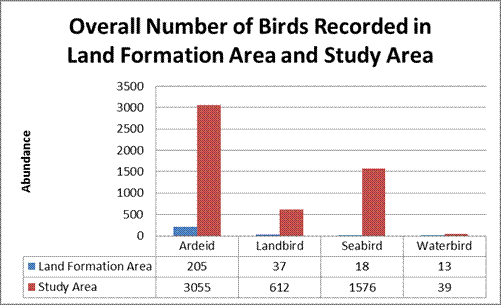
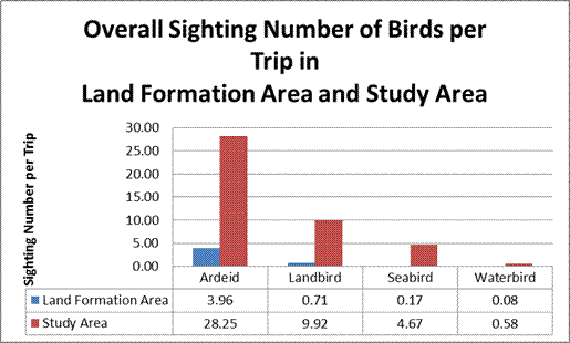
Chart 12.2 Overall Sighting Number of Birds per Trip in
Land Formation Area and Study Area from 24 Rounds of
Boat Survey in 12 Months
12.5.1.5
Although the size of land formation area and study area are not
directly comparable, the charts show the importance of the land formation area
for birds in the context of whole study area in northern Lantau waters. Chart 12.1
indicates that the number of seabirds (wintering gull species and cormorants)
recorded from the land formation area accounts for only 1.2 % of the total
number recorded in the study area. Similarly, the number of ardeids observed in
the land formation area is about 6.7 % of the total number recorded in the
study area. When compared to seabirds and ardeids, landbirds and waterbirds
recorded in the study area are generally of much lower abundance owing to the
lack of suitable habitats and the land formation area does not show specific
significance to these two bird groups. Regarding the raptors of conservation
interest, the distribution maps as given in Drawings MCL/P132/EIA/12-016a8 and MCL/P132/EIA/12-016a9 show that the
land formation area is again not frequently utilised by raptors.
12.5.2 Bird
Community and Utilisation in Land Formation Area
12.5.2.1
In order to identify bird’s activities in the land formation area,
bird count records within the land formation area were obtained from both boat
surveys and land-based surveys at North and Northeast Stations (exclusively
those recorded at open sea and artificial seawall) are extracted for detailed
analysis. In summary, a total of 65 bird species were recorded within the
land
formation area, which represent 43.6 % of the total number of bird
species recorded during the avifauna surveys. The bird species recorded in the land
formation area with a breakdown by season, flight heights, bird groups, behaviour
and activities, are presented in Annex M
of Appendix
12.3, and are summarised in Table 12.1.
Table 12.1 Summary of Bird Survey Records in Land
Formation Area
|
Observation |
Number of Birds Recorded |
||||||
|
North
Station (birds
per hour) |
Northeast
Station (birds per hour) |
Boat
Survey (birds
per trip) |
|||||
|
Behaviour and
Activity |
|||||||
|
Flying - Foraging |
Ardeid |
0 |
0 |
0.03 |
0.2 % |
0.42 |
3.7 % |
|
Landbird |
0.08 |
0.9 % |
0.11 |
0.8 % |
0.17 |
1.5 % |
|
|
Seabird |
0 |
0 |
0 |
0 |
0 |
0 |
|
|
Waterbird |
0 |
0 |
0 |
0 |
0 |
0 |
|
|
Sub-total |
0.08 |
0.9 % |
0.14 |
1.1 % |
0.58 |
5.1 % |
|
|
Flying - Travelling |
Ardeid |
0.90 |
9.8 % |
3.68 |
27.8 % |
1.88 |
16.5 % |
|
Landbird |
1.79 |
19.5 % |
2.32 |
17.5 % |
0.96 |
8.4 % |
|
|
Seabird |
0.18 |
2.0 % |
0.11 |
0.8 % |
0.71 |
6.2 % |
|
|
Waterbird |
0.43 |
4.7 % |
0.29 |
2.2 % |
0.50 |
4.4 % |
|
|
Sub-total |
3.31 |
35.9 % |
6.40 |
48.4 % |
4.04 |
35.5 % |
|
|
Flying - Unknown |
Ardeid |
0.49 |
5.3 % |
0.15 |
1.2 % |
0 |
0 |
|
Landbird |
0.74 |
8.0 % |
0.10 |
0.7 % |
0 |
0 |
|
|
Seabird |
0.69 |
7.5 % |
0.14 |
1.0 % |
0 |
0 |
|
|
Waterbird |
0.19 |
2.1 % |
0 |
0 |
0 |
0 |
|
|
Sub-total |
2.11 |
22.9 % |
0.39 |
2.9 % |
0 |
0 % |
|
|
Perching - Foraging |
Ardeid |
1.15 |
12.5 % |
0.64 |
4.8 % |
2.96 |
26.0 % |
|
Landbird |
0.13 |
1.4 % |
0.54 |
4.1 % |
0.04 |
0.4 % |
|
|
Seabird |
0 |
0 |
0 |
0 |
0 |
0 |
|
|
Waterbird |
0.07 |
0.8 % |
0.01 |
0.1 % |
0 |
0 |
|
|
Sub-total |
1.35 |
14.6 % |
1.19 |
9.0 % |
3.00 |
26.5 % |
|
|
Perching - Roosting |
Ardeid |
0.61 |
6.6 % |
1.74 |
13.1 % |
3.00 |
26.4 % |
|
Landbird |
0.29 |
3.2 % |
1.97 |
14.9 % |
0.38 |
3.3 % |
|
|
Seabird |
0 |
0 |
0.03 |
0.2 % |
0 |
0 |
|
|
Waterbird |
0.10 |
1.1 % |
0.03 |
0.2 % |
0.04 |
0.4 % |
|
|
Sub-total |
1.00 |
10.9 % |
3.76 |
28.5 % |
3.42 |
30.0 % |
|
|
Perching - Unknown |
Ardeid |
0.51 |
5.6 % |
0.24 |
1.8 % |
0.29 |
2.6 % |
|
Landbird |
0.08 |
0.9 % |
0.17 |
1.3 % |
0 |
0 |
|
|
Seabird |
0 |
0 |
0.08 |
0.6 % |
0.04 |
0.4 % |
|
|
Waterbird |
0.03 |
0.3 % |
0 |
0 |
0 |
0 |
|
|
Sub-total |
0.63 |
6.8 % |
0.49 |
3.7 % |
0.33 |
2.9 % |
|
|
Moving Locally – Foraging |
Ardeid |
0.13 |
1.4 % |
0.01 |
0.1 % |
0 |
0 |
|
Landbird |
0.03 |
0.3 % |
0.07 |
0.5 % |
0 |
0 |
|
|
Seabird |
0 |
0 |
0 |
0 |
0 |
0 |
|
|
Waterbird |
0.06 |
0.6 % |
0 |
0 |
0 |
0 |
|
|
Sub-total |
0.21 |
2.3 % |
0.08 |
0.6 % |
0 |
0 % |
|
|
Moving Locally - Unknown |
Ardeid |
0.31 |
3.3 % |
0.51 |
3.9 % |
0 |
0 |
|
Landbird |
0.14 |
1.5 % |
0.17 |
1.3 % |
0 |
0 |
|
|
Seabird |
0 |
0 |
0.06 |
0.4 % |
0 |
0 |
|
|
Waterbird |
0.08 |
0.9 % |
0.03 |
0.2 % |
0 |
0 |
|
|
Sub-total |
0.53 |
5.7 % |
0.76 |
5.8 % |
0 |
0 % |
|
|
Total |
|
9.21 |
100 % |
13.22 |
100 % |
11.38 |
100 % |
|
Season |
|
|
|
|
|
|
|
|
Fall |
Ardeid |
1.35 |
14.6 % |
2.07 |
15.7 % |
1.54 |
13.6 % |
|
Landbird |
0.94 |
10.3 % |
2.82 |
21.3 % |
0.08 |
0.7 % |
|
|
Seabird |
0 |
0 |
0 |
0 |
0 |
0 |
|
|
Waterbird |
0.25 |
2.7 % |
0.04 |
0.3 % |
0 |
0 |
|
|
Sub-total |
2.54 |
27.6 % |
4.93 |
37.3 % |
1.63 |
14.3 % |
|
|
Spring |
Ardeid |
1.10 |
11.9 % |
1.22 |
9.2 % |
3.04 |
26.7 % |
|
Landbird |
1.26 |
13.7 % |
1.21 |
9.1 % |
0.21 |
1.8 % |
|
|
Seabird |
0.22 |
2.4 % |
0.08 |
0.6 % |
0 |
0 |
|
|
Waterbird |
0.51 |
5.6 % |
0.29 |
2.2 % |
0.54 |
4.8 % |
|
|
Sub-total |
3.10 |
33.6 % |
2.81 |
21.2 % |
3.79 |
33.3 % |
|
|
Summer |
Ardeid |
0.75 |
8.1 % |
3.06 |
23.1 % |
2.17 |
19.0 % |
|
Landbird |
0.71 |
7.7 % |
0.33 |
2.5 % |
0.96 |
8.4 % |
|
|
Seabird |
0.46 |
5.0 % |
0 |
0 |
0.38 |
3.3 % |
|
|
Waterbird |
0.08 |
0.9 % |
0.03 |
0.2 % |
0 |
0 |
|
|
Sub-total |
2.00 |
21.7 % |
3.42 |
25.8 % |
3.50 |
30.8 % |
|
|
Winter |
Ardeid |
0.90 |
9.8 % |
0.65 |
4.9 % |
1.79 |
15.8 % |
|
Landbird |
0.36 |
3.9 % |
1.08 |
8.2 % |
0.29 |
2.6 % |
|
|
Seabird |
0.19 |
2.1 % |
0.34 |
2.6 % |
0.38 |
3.3 % |
|
|
Waterbird |
0.11 |
1.2 % |
0 |
0 |
0.00 |
0 |
|
|
Sub-total |
1.57 |
17.1 % |
2.07 |
15.7 % |
2.46 |
21.6 % |
|
|
Total |
|
9.21 |
100 % |
13.22 |
100 % |
11.38 |
100 % |
|
Flight Height* |
|
|
|
|
|
|
|
|
0-10 m |
Ardeid |
1.13 |
21.6 % |
2.69 |
40.1 % |
1.38 |
29.7 % |
|
Landbird |
1.68 |
32.3 % |
0.94 |
14.0 % |
0.96 |
20.7 % |
|
|
Seabird |
0.22 |
4.3 % |
0.06 |
0.9 % |
0.42 |
9.0 % |
|
|
Waterbird |
0.51 |
9.9 % |
0.28 |
4.2 % |
0.50 |
10.8 % |
|
|
Sub-total |
3.54 |
68.0 % |
3.97 |
59.2 % |
3.25 |
70.3 % |
|
|
11-50 m |
Ardeid |
0.15 |
2.9 % |
0.88 |
13.0 % |
0.92 |
19.8 % |
|
Landbird |
0.83 |
16.0 % |
1.24 |
18.4 % |
0.17 |
3.6 % |
|
|
Seabird |
0.65 |
12.5 % |
0.19 |
2.9 % |
0.29 |
6.3 % |
|
|
Waterbird |
0.03 |
0.5 % |
0 |
0 |
0 |
0 |
|
|
Sub-total |
1.67 |
32.0 % |
2.31 |
34.4 % |
1.38 |
29.7 % |
|
|
>50 m |
Ardeid |
0 |
0 |
0.18 |
2.7 % |
0 |
0 |
|
Landbird |
0 |
0 |
0.25 |
3.7 % |
0 |
0 |
|
|
Seabird |
0 |
0 |
0 |
0 |
0 |
0 |
|
|
Waterbird |
0 |
0 |
0 |
0 |
0 |
0 |
|
|
Sub-total |
0.00 |
0 % |
0.43 |
6.4 % |
0 |
0 % |
|
|
Total |
|
5.21 |
100 % |
6.71 |
100 % |
4.63 |
100 % |
|
Bird Group |
|
|
|
|
|
|
|
|
Ardeid |
4.10 |
44.5 % |
7.00 |
52.9 % |
8.54 |
75.1 % |
|
|
Landbird |
3.28 |
35.6 % |
5.44 |
41.3 % |
1.54 |
13.6 % |
|
|
Seabird |
0.88 |
9.5 % |
0.42 |
3.1 % |
0.75 |
6.6 % |
|
|
Waterbird |
0.96 |
10.4 % |
0.36 |
2.7 % |
0.54 |
4.7 % |
|
|
Total |
9.21 |
100 % |
13.22 |
100 % |
11.38 |
100 % |
|
Note: * Only the records with flying behaviour and defined flight height are extracted for analysis.
12.5.2.2
The records presented in Table 12.1 comprise coastal (the artificial
seawall of existing airport island) and pelagic habitats within the land
formation area
during the course of avifauna surveys. The records comprise of 11.38 birds per trip for boat surveys, 9.12 birds per hours recorded from land-based survey at North Station and 13.22 birds
per trip for
Northeast Station.
Bird Groups
12.5.2.3
With reference to the boat survey findings, the major bird group recorded
in the land formation area is the ardeid species, which accounts for 75.1
% of the
total record, followed by landbirds (13.6 %), whilst seabirds only account for 6.6 % of the total record
and clustered in a particular area (see Drawing MCL/P132/EIA/12-016a2). The percentages shown in
land-based survey are slightly different but they similarly indicate the
dominance of ardeid. Amongst the ardeid bird group, Little Egret is the
dominant species recorded in the land formation area covering both open sea and coastal
habitat (See Drawing MCL/P132/EIA/12-016a2). Little Egret accounts
for 72 % of the total record from boat survey and 44.5 % of
the total record from land-based survey (Table B in Annex
M in Appendix
12.3). The most common landbird (second commonest in all bird groups) is Barn
Swallow, which accounts for 6.6 % of the boat survey record and 9.2 % of the land-based survey
record. They are mostly recorded with travelling activities across the land
formation area near the artificial
seawall (see Drawing MCL/P132/EIA/12-016a2).
Behaviour and Activity
Travelling
as the Main Activity
12.5.2.4
From the land-based or boat survey
results, travelling was the most commonly observed activity for the birds
recorded within the land formation area, accounting for 35.5 % - 48.4 % of the total bird records. The travelling activities are mainly attributed to the local movement
of ardeids.
Foraging
at Artificial
Seawall and Open Sea
12.5.2.5
Between 9.0 % and 26.5 % of the total bird
records from land-based or boat surveys were found foraging while perching. From the boat survey data,
foraging activities were attributed to 39.8 % of the recorded Little
Egrets (dominant species under the ardeid bird group) , whilst the
corresponding percentage from land-based survey is 17.7 % (Table A in Annex M
in Appendix
12.3). The foraging activities within the land formation area
recorded from boat survey were illustrated in Drawing MCL/P132/EIA/12-016c.
12.5.2.6
Foraging along the existing artificial seawall of
airport island was
recorded during the surveys. The big armour rocks are commonly used by the the
ardeids as
stepping stones to forage over coastal areas. Other than Little
Egrets, two species associated with rocky shore, the Common Sandpiper and
Pacific Reef Heron were also found foraging along the
artificial seawall. Both species are solitary, thus the numbers recorded on the artificial
seawall are
rather low.
12.5.2.7
Little Egret is also the key species foraging in the
open area whereas most of the waterbirds and landbirds
are not adapted to forage over open sea. One exceptional case of
landbird that can forage over sea and is also recorded in the land formation area is Black Kite. It is a
ubiquitous species that distributes in a wide range of habitats and has a behaviour of soaring over sea
for foraging. Black Kite was recorded soaring over the land
formation area and foraging from sea surface.
No
Breeding Sites
12.5.2.8
No sign of breeding behaviour or nests was observed
within the land formation area during the avifauna surveys, and there is no
information from literature which suggests the presence of breeding site within
the land formation area. Both the existing artificial seawall and the
open sea within the land formation area are thus unlikely to be breeding sites for the
recorded bird
species. The nearest known breeding sites to the land
formation area are the Sha Chau egretry and the breeding pair of White-bellied
Sea Eagle on Lung Kwu Chau.
Seasonality
12.5.2.9
Based on the land-based survey
results, the highest number of birds was recorded in spring for the
North Station
and in autumn
for the Northeast
Station, whilst winter is the season with the lowest abundance for both stations. From the
boat survey results, the highest number of birds was found in spring
but the lowest number of birds was recorded in autumn. The results from different surveys seem
to suggest that
the seasonality of birds within the land formation area
is not particularly apparent.
Flight Height
12.5.2.10 Categorisation of flight
height is defined according to the bird’s flying practice over open sea.
0-10 m includes most of the activities that is associated with open sea
surface, such as foraging over sea; 11-50 m includes most of the flight
activities related to travelling; whilst >50 m includes the soaring
behaviour of some species, noticeably large raptor species.
12.5.2.11 The majority (59.2 % - 70.3 %) of the birds observed during the land-based or boat surveys were within the range of 0-10 m above sea level, with
some 29.7
% - 34.4
% of the birds
recorded in
the range of 11-50 m. Only a small portion (not more than 6.4
%) of the birds were observed at over 50 m above sea level. The highest
percentage of birds recorded at relatively low flight height could be attributed to the large proportion of ardeid
species which mostly travel at a level not
high above sea surface.
Ecological Evaluation of Land Formation Area (Open Sea) and Northern Artificial
Seawall
12.5.2.12 The land formation area and the artificial seawall
is part of the sea in North Lantau. Marine habitat is generally not important
to terrestrial fauna, but a small community of bird was recorded in the land
formation area. Little Egret is the dominant species in the community but their
abundance in land formation area is relatively low. The land formation area is
not particularly important in the context of whole northern Lantau waters for
ardeids. Other species recorded are mostly in passage stage. The ecological
evaluation of the land formation area (open sea) and the artificial seawall
along the existing runway were extracted from Appendix 12.4 and presented in Tables 12.2 and 12.3 below.
Table12.2: Ecological
Evaluation of Land Formation Area (Open Sea) for Avifauna
|
Criteria |
Open Sea
in Location C |
|
Naturalness |
Natural
habitat |
|
Size |
Approximately 650 ha |
|
Diversity |
Moderate in avifauna diversity
(43 species) |
|
Rarity |
This habitat type is common in
Hong Kong; 14 avifauna species of
conservation interest are recorded, including Great Egret Ardea alba, Grey Heron Ardea cinerea, Great Knot Calidris tenuirostris, Greater Sand
Plover Charadrius leschenaultii,
Black-headed Gull Chroicocephalus
ridibundus, Little Egret Egretta
garzetta, Pacific Reef Heron Egretta
sacra, Peregrine Falcon Falco
peregrinus, Common Kestrel Falco
tinnunculus, Black-tailed Godwit Limosa
limosa, Black Kite Milvus migrans,
Western Osprey Pandion haliaetus,
Great Cormorant Phalacrocorax carbo,
Terek Sandpiper Xenus cinereus |
|
Re-creatability |
Not able to be re-created |
|
Fragmentation |
Not fragmented |
|
Ecological linkage |
The
ardeids utilise the sea over the land formation area is ecologically linked
to the Sha Chau egretry |
|
Potential value |
Low
potential value to avifauna with respect to the low species abundance and
diversity recorded. |
|
Nursery/ breeding ground |
No significant nursery or breeding ground recorded |
|
Age |
Unknown |
|
Abundance/ Richness of wildlife |
Moderate species richness for
avifauna (43 species) with low abundance, dominantly Little Egret |
|
Ecological value |
Low ecological value for
avifauna |
Table 12.3: Ecological Evaluation of Artificial Seawall Along the North Coast of Existing Runways for Avifauna
|
Criteria |
Artificial
Seawall in Location C |
|
Naturalness |
Man-made
habitat |
|
Size |
Approximately 5 km long |
|
Diversity |
Moderate in avifauna diversity
(44 avifauna) |
|
Rarity |
This artificial habitat type
is common in Hong Kong; 12 avifauna species of
conservation interest are recorded, including Great Egret Ardea alba, Grey Heron Ardea cinerea, Chinese Pond Heron Ardeola bacchus, Kentish Plover Charadrius alexandrinus, Little Egret Egretta garzetta, Pacific Reef Heron Egretta sacra, Yellow-breasted Bunting
Emberiza aureola, Peregrine Falcon Falco peregrinus, Common Kestrel Falco tinnunculus, Black Kite Milvus migrans, Western Osprey Pandion haliaetus, Red-billed Starling
Spodiopsar sericeus |
|
Re-creatability |
Can be readily re-created |
|
Fragmentation |
Not fragmented |
|
Ecological linkage |
Not
functionally linked to any habitats of high ecological value |
|
Potential value |
Low
potential value to avifauna with respect to the low species abundance and
diversity recorded. |
|
Nursery/ breeding ground |
No significant nursery or breeding ground recorded |
|
Age |
16 years |
|
Abundance/ Richness of wildlife |
Moderate species richness for
avifauna (44 species) with low abundance, dominantly Little Egret |
|
Ecological value |
Low ecological value for
avifauna |
12.5.3 Bird Community in Northern Lantau
waters
Bird
Groups
12.5.3.1
The bird community in the northern Lantau waters, including the land formation area, is dominated
by ardeids. The ardeid
community including Little Egret, Great
Egret, Pacific Reef Heron and Black-crowned Night Heron, was widely recorded in the
study area and mostly associated with coastal habitats in North Lantau, SCLKC Marine Park and along
Urmston Road. The artificial coastlines in North Lantau,
including HKIA, and marine construction sites are also commonly used by the species. The use of marine
construction sites for foraging place is shown in Drawing MCL/P132/EIA/12-016a2, in which a large number of ardeids were recorded at the HKBCF project site
where egrets
were found perching on top of the
floating parts of silt curtains around the site for foraging.
12.5.3.2
Seabirds were mainly recorded in open areas and were
seldom found
in coastal
areas. Generally,
the abundance
of seabirds in Hong Kong is highly seasonal. The grid maps for seabirds in four
seasons (Drawing MCL/P132/EIA/12-016a6) show a relatively high abundance in winter
season, which is attributed to the wintering gulls such as Black-headed Gull
and Heuglin’s Gull, but a lower abundance
in other
seasons. Aggregation of wintering gulls were
found mostly along the Urmston Road and SCLKC Marine Park, but
they were seldom recorded in
coastal water area.
12.5.3.3
Due to a lack of suitable wetland habitat in the study area the
abundance of waterbirds (excluding ardeids) is very low (only 142 individuals
encountered in 24 rounds of boat surveys or an average of 5.9 individuals per
round), the exception to this statement being the rocky shore specialist
species such as the Common Sandpiper. Small flocks of migratory waders such as the
Red-necked
Stint were occasionally seen during the migratory season, and were mostly associated with
coastal area.
12.5.3.4
The landbirds recorded in the study area were usually
travelling across the study area, as these bird groups usually do not land on
open waters. An exception to this statement is the raptor species, Black Kite, which is highly
associated with open sea as well as coastal areas when foraging. Black Kites
usually soar over sea, search for dead fish and dash to the sea surface to
collect food. Owing to their ubiquitous habit, they were widely recorded over the
study area. The land formation area is not particularly important to them. Another raptor species associated
with marine environment is the White-bellied Sea Eagle which has also been recorded in the
study area. There is an established nesting location of the White-bellied Sea
Eagle at Lung Kwu Chau, and thus these birds were recorded several times during
the boat survey, mostly at Lung Kwu Chau and the adjacent inshore waters. In
addition to these two raptors, Barn Swallows were also widely recorded
travelling across the open sea area.
Breeding Activity
12.5.3.5
There are no breeding sites for birds in the
open
waters to the north of the existing airport island. Breeding activities within
the study area are
found
in SCLKC area,
where the extent of human disturbance is low.
12.5.3.6
The main breeding activity recorded in the study area is the egretry on
Sheung Sha
Chau Island.
The breeding community consists mainly of Little Egret and
Black-crowned Night Heron, and a small number of Great Egret and Pacific Reef
Heron (details presented in Section 3.4
in Appendix
12.3). Based on the egretry flight path survey results, it was found that a considerable portion of the breeding community used Sheung Sha Chau Island and the adjacent waters for foraging (refer to Drawings MCL/P132/EIA/12-016e1 and MCL/P132/EIA/12-016e2).
12.5.3.7
Another noticeable breeding activity recorded in the study area is the
established White-bellied Sea Eagle nest in Lung Kwu Chau. Owing to the
presence of the nesting location, the species was mostly recorded in Lung Kwu Chau during the boat survey
(distribution shown in Drawing MCL/P132/EIA/12-016a9).
Use
of Existing Runway
12.5.3.8
Due to its vast and flat open area, the existing airport runway and adjacent
grassland area often attract open country birds. The airfield bird data
collected by the AAHK’s Bird Control Unit indicates that the dominant bird species are
generalists or open country species such as the Eurasian Tree Sparrow,
Richard’s Pipit and Crested Myna. A small number of various migratory birds were recorded on the runway, including waterbird species such as
Sanderling, Red-necked Stint, plover species, and raptor species such as Common Kestrel (species
list given in Annex C of Appendix 12.1). A higher number of
bird counts were noted during the autumn and this is consistent with the observation from the
land-based survey conducted on Sha Chau which suggests a southward migration or dispersive
movement of
landbirds in autumn. It appears that a
small number of birds use the runway as a stopover point during
their long migration journey or dispersive movement.
Flight
Movement
12.5.3.9
No apparent flight path can be identified
from the land-based
surveys undertaken within and near the land formation area. By contrast, the survey station on Sha Chau has recorded moderate-low bird abundance and detected frequent uni-directional movement in the
migratory
season. This landbird group predominantly moves in a southward
and south-westward direction during the autumn and winter seasons. This southward moving
pattern is consistent with general migratory activities
that happen in Hong Kong, as the passage migrants and winter visitors mostly travel from north
to south during spring and winter migration seasons. It suggests a small bird
community utilises Sha Chau as a stopover point during southward migration or
dispersive movement.
12.5.3.10 The flight movement across the study
area is usually at low altitude. The flight height analysis results show that most of the
birds in flight records fall in the range of 0-10 m above sea level,
followed by the range of 11-50 m. Not many birds fall in the range of >50 m except the
Black Kite
which soars over the
open waters.
Ecological
Value of Northern Lantau waters
12.5.3.11 Other than some bird
species associated with marine environment northern
Lantau waters
is generally not important for terrestrial fauna. Some bird groups, mainly
ardeid and seabird, have been widely recorded in the northern
Lantau waters.
Ardeid is the major bird group recorded in northern
Lantau waters
with an egretry established on Sha Chau. The seabird community consists of mainly winter visitors and passage migrants such as gulls and terns.
Their distribution in northern Lantau waters has mainly been
found near
Sha Chau, Lung Kwu Chau and Urmston Road. Other than ardeid and seabird, a few
raptors species which have marine water associated behaviour, including Black
Kite, White-bellied Sea Eagle and Western Osprey, have been recorded in northern Lantau waters. From a terrestrial ecology
perspective, the main function of the northern Lantau waters is to provide a marine habitat
for the ardeid community and a few
raptor species associated with marine environment; and an over-wintering habitat for
gull dominated seabird community.
12.5.4
Other Terrestrial Flora and Fauna
Species at Off-site Habitats
12.5.4.1
Apart from the baseline avifauna surveys,
other terrestrial flora and fauna surveys have also been carried out at
off-site habitats (i.e. outside
the project area). Details of the survey findings are documented in Appendix 12.3,
and are also summarised below.
12.5.4.2
The hilly terrain of North Lantau is dominated by hillside shrubland and
woodland. Along the coastline, lowland habitat including seasonal wet grassland
and shrubby grassland are found in sporadic locations, mainly near the village
areas. 32 terrestrial floral species of conservation interest have been
recorded in the study area (but outside the
project area), most of which are found in woodland and shrubland
habitats. Some of these species are locally common, such as the Incense Tree Aquilaria sinensis, Cansjera rheedii, Lamb of Tartary Cibotium barometz, Small Persimmon Diospyros vaccinioides, Hong Kong
Pavetta Pavetta hongkongensis and
Portia Tree Thespesia populnea.
12.5.4.3
In terms of fauna species, there are widespread
records of endemic and endangered amphibian species, including Romer’s Tree
Frog and Short-legged Toad in North Lantau. Reptile species recorded in North Lantau are mostly widespread species except for the Tokay Gecko which has
limited distribution in Hong Kong including North Lantau.
12.5.4.4
Butterflies however are more widely recorded in the study area
(but outside the project area), with a
butterfly hotspot identified at San Tau. There are however no hotspots or endangered species for
dragonfly species identified in the North Lantau study area. A few freshwater fish
species of conservation interest were recorded in lowland streams
in Sham Wat,
Sha Lo Wan, San Tau, Tung Chung, Pak Mong and Tai Ho.
12.6
Prediction
and Evaluation of Impact
12.6.1 General
12.6.1.1
The project description is detailed in Chapter 4 of
this EIA report. The 3RS additional seawalls and land platform will be formed
over a period of several years starting in late 2015 / early 2016 to mid-2022.
The proposed land formation and associated works and the future operation of
the third runway project may affect the terrestrial ecology within the project
footprint and adjacent waters. This section identifies the potential
impact of the project on terrestrial ecology.
12.6.1.2
The potential ecological effects due to loss of habitat
would include loss of breeding and feeding ground for bird fauna, reduction of
species abundance/diversity, reduction of ecological carrying capacity, habitat
fragmentation, loss of terrestrial habitat and formation of terrestrial
habitat. Loss of habitat and the associated ecological effects would occur in both
construction and operation phases, whilst the effect of formation of terrestrial
habitat would occur in operation phase.
12.6.1.3
The potential disturbance effect during construction phase would
include impact to Sha Chau egretry, habitat disturbance, disturbance to species
of conservation interest and impact on freshwater fish community. During
operation of 3RS, the potential impacts would include impact to flight movement of birds, disturbance to
species of conservation interest and habitat disturbance.
12.6.1.4
On the basis of the baseline ecological information of the study
area, the potential impacts on terrestrial ecology due to the proposed project
were evaluated in accordance with the criteria set forth in the EIAO-TM. In the
following sections both construction phase and operation phase impacts are
evaluated.
12.6.1.5
The impact items identified as relevant to this
project include:
¡ Direct
Impact of Habitat Loss;
¡ Indirect
Impact to Sha Chau Egretry;
¡ Impact
to Flight Movement and Behaviour of Birds;
¡ Habitat
Disturbance;
¡ Disturbance
to Species of Conservation Interest; and
¡ Impact
on Freshwater Fish Community
12.6.1.6
Except impact to flight movement and behaviour of bird which happens
only in operation phase, other impacts are assessed for both construction and operation phases. Impact
levels are ranked as “high”, “moderate-high”, “moderate”, "moderate-low”, “low” and “negligible”.
12.6.2
Habitat Loss
Loss of Feeding and Breeding Grounds
12.6.2.1
The proposed land formation works will result in loss of 5.9 km of artificial seawall along
the
north coast of
existing airport island and loss of 650 ha of open sea area to the north
of the HKIA.
However, neither the open sea nor the existing artificial seawall are breeding sites for terrestrial fauna and as a result the loss of breeding grounds for terrestrial fauna in the project area
is not expected.
12.6.2.2
Although the artificial seawall is not a natural habitat
for terrestrial fauna, due to its proximity to open waters the big rock armour in the artificial seawall is often used by birds for
foraging. The use of the artificial seawall by bird species is discussed in the Section 12.5.2. It was
evaluated (in Table 30 in Appendix 12.4) that the artificial seawall
along the north coast of existing airport island is not an important foraging
ground for birds.
12.6.2.3
As shown in Annexes
M and N of Appendix 12.3 which have also been described in Section 12.5.2, the dominant bird species found in the
land formation area is Little Egret (in both open sea and coastal habitat).
They forage and temporarily roost in the intertidal area of the artificial
seawall, but return to communal roosting site at night time.
12.6.2.4
Other than the Little Egret, there are a few rocky
shore species, including the Pacific Reef Heron and Common
Sandpiper, recorded foraging along the artificial seawall. However,
the abundance of these rocky shore associated species is not significant in the
context of the northern Lantau waters (low abundance of ardeid and waterbird in
the land formation area as compared to the study area as shown in Chart 12.1),
suggesting that the land formation area is not an important foraging habitat
for ardeids and rocky shore specialised species. Hence, the loss of artificial seawall would
not result in significant loss of feeding ground.
12.6.2.5
Furthermore, the loss of foraging area would only occur temporarily, as a new and longer seawall of about 13 km
in length will
be constructed as an early part of the land formation process. It was also observed during the boat
transect survey that ardeids make use of the silt
curtain (provided under another unrelated project) as a foraging platform.
This suggests that the temporary loss of the existing artificial wall as a foraging ground for ardeid will be offset by the new seawall
and other foraging sites (silt curtains) during the construction phase. Other rocky shore
foraging species are of low occurrence and the removal of
the existing artificial
seawall would not have
significant implication to their population.
12.6.2.6
In the open waters to the north of the
existing airport island the dominant bird species recorded was the Little Egret. Other than
the Little
Egret, the most frequently recorded species are Black Kite and Barn Swallow.
Foraging over open area is noted for Little Egret and Black Kite but not for
Barn Swallow. Although the 650 ha land formation would result in loss of open
sea for foraging ardeid, the installation of new seawall would re-provide
another foraging opportunity. As the land formation area is not particularly
important to ardeid in the context of northern Lantau waters, the loss of the open sea
would not have significant impact to them.
12.6.2.7
For Black Kite, the potential impact is relatively low, as this ubiquitous
species can make use of a wide range of habitats in Hong Kong and it has been shown that the land formation area is
not particularly important for this species.
12.6.2.8
The land formation area has low abundance and
significance as birds’
feeding ground,
and thus the impact of the loss
of the area as a foraging ground is considered to be low during both
construction and operation phases. During operation phase, the
conversion of habitat from open sea to formed land would increase the land area
and foraging opportunity for land birds but the effect is minimal. Similarly,
the extension of artificial seawall would be beneficial for the
ardeids foraging at coastal areas. The evaluation
of the impact of the habitat loss
on avifauna is
summarised in Table
12.4.
Reduction of Species Abundance/Diversity
12.6.2.9 Reduction of species abundance and diversity is largely dependent on whether there would be any significant impact on foraging or breeding ground that has implication on species’ foraging and breeding capacity.
12.6.2.10 As discussed above, there will not be a loss of breeding ground arising from the project. In the context of foraging capacity, it has been evaluated that the land formation area is not an important foraging site for terrestrial fauna/birds. Although ardeids are commonly found foraging at the intertidal seawalls it is noted that they are well adapted to all types of intertidal habitats in the open waters of North Lantau and that the land formation area is not particularly important to the species. Construction activities which may cause temporary loss of artificial seawall (which will be restored by new and longer seawall in the early stage of construction) would have no impact on the foraging opportunity of the ardeid species. Therefore, the proposed project would not result in a reduction in the species abundance or diversity of terrestrial fauna species during both construction and operation phases.
12.6.2.11
After land formation, the terrestrial habitat created
by this project could provide a temporary stopover point for migratory birds
during the migratory journey which may have some positive effect on species
abundance and diversity. The bird community present in the formed land would be
dominantly open country and generalist bird species. Compared to the ardeid
community at existing coastal waters, there will be a change in bird community.
The formed land would be beneficial to the land bird species which may increase
in abundance but the effect is expected to be insignificant.
Reduction of Ecological Carrying Capacity
12.6.2.12 Ecological carrying capacity is defined as the maximum density of a species that the resources in a particular habitat can support (Odum & Barrett, 2005). The carrying capacity of an area will be affected by changes in resource availability including food resources, space, breeding ground and other abiotic factors. For avifauna, carrying capacity is closely linked with the reduction of bird species abundance/diversity and loss of feeding and breeding grounds.
12.6.2.13 The land formation area itself is not a breeding ground for terrestrial fauna. Any potential disturbance to the Sha Chau egretry due to the installation of the twin pipelines on Sheung Sha Chau Island will be mitigated (details provided in Section 12.7.2) and would not cause loss of breeding ground for ardeids.
12.6.2.14
In relation to feeding
habitat, the land formation area itself is not a significant site of food
source for terrestrial fauna species. The artificial seawall along the north
coast of the existing airport island only provides a stepping stone for rocky
shore bird species foraging over the intertidal area but would not generate a
significant amount of food sources for terrestrial fauna.
12.6.2.15 The loss of marine habitat in land formation might divert the birds feeding on the sea to adjacent area in northern Lantau waters which might increase the loading (number of feeding birds) of other area. However, owing to the low abundance of birds in the land formation area, the effect is expected to be negligible and no impact will be resulted on the ecological carrying capacity.
Habitat Fragmentation
12.6.2.16
Habitat fragmentation occurs
when the landscape transformation includes the breaking of large habitat into
small pieces (Forman 1997). Not only does it result in a reduction in
population size, but also a division of the original population into
subpopulation and creation of edge habitats (Burgman et al. 1993).
12.6.2.17 The proposed project involves formation of 650 ha of land in northern Lantau waters which will result in a loss of marine habitat but not terrestrial habitat. The land formation area is adjoining to the existing runway, which would not fragment large continuous terrestrial habitat or marine area that is important for terrestrial fauna use, such as foraging habitat. Therefore, the effect of habitat fragmentation is not expected.
Loss of Terrestrial Habitat
12.6.2.18
Loss of terrestrial habitat is generally not a concern
as the new runway will be formed over the sea. Loss of terrestrial habitat will
mainly occur at artificial habitats at the airport island, which is of low
ecological value. Some landscape features, such as roadside planting and the SkyCity Nine Eagles Golf
Course may provide a stopover point for occasional migrating birds but they
could not provide a natural feeding ground. As these habitats are not
considered important from an ecological perspective, the ecological impact due
to loss of the terrestrial habitat is expected to be of low significance and no
unacceptable impact is anticipated.
Formation of Terrestrial Habitat
12.6.2.19
During operation of the 3RS, the new runway would
create a terrestrial habitat. The newly formed open area is likely to be of a
similar ecological value to the existing runway and with limited ecological
potential. With reference to the survey results by the AAHK’s Bird Control Unit
and expert consultants, the airport runway would provide a temporary stopover
habitat for open country or generalist birds. The ecological value of the
formation of the new terrestrial habitat is considered as low.
|
Criteria |
Habitat
Loss |
|
Habitat Quality |
The land formation area is located in the northern Lantau waters just to the north of the existing runway where sightings of birds are low and dominated by Little Egret. The marine water in the land formation area is generally not an important habitat for birds. The actual habitat quality is low for terrestrial ecology. |
|
Species |
Mainly ardeids, waterbirds and seabird species, 18 species of conservation interest including Great Egret Ardea alba, Grey Heron Ardea cinerea, Chinese Pond Heron Ardea bacchus, Great Knot Calidris tenuirostris, Kentish Plover Charadrius alexandrinus, Greater Sand Plover Charadrius leschenaultii, Black-headed Gull Chroicocephalus ridibundus, Little Egret Egretta garzetta, Pacific Reef Heron Egretta sacra, Yellow-breasted Bunting Emberiza aureola, Peregrine Falcon Falco peregrinus, Common Kestrel Falco tinnunculus, Black-tailed Godwit Limosa limosa, Black Kite Milvus migrans, Western Osprey Pandion haliaetus, Great Cormorant Phalacrocorax carbo, Red-billed Starling Spodiopsar sericeus, Terek Sandpiper Xenus cinereus |
|
Size/Abundance |
Large in affected marine water area but low in species abundance |
|
Duration |
Marine water: permanent loss of 650 ha of open sea area after completion of the land formation works. Artificial seawall: temporary loss during construction phase as longer (13 km) artificial seawall will be restored in early stage of construction phase; and the floating silt curtain in marine construction site could provide alternative foraging ground during construction. |
|
Reversibility |
Irreversible for the permanent loss of marine water; reversible for the temporary loss of artificial seawall |
|
Magnitude |
Low due to the absence of significant feeding and breeding ground under project footprint |
|
Overall Degree of Impact |
Low due to the relative low density of birds and foraging activities in the affected marine water during both construction and operation phases |
12.6.3 Impact
to Sha Chau Egretry
12.6.3.1
Horizontal Directional Drilling (HDD) is
proposed for engineering the approximately 1 m diameter parallel drill holes
through the deep rock stratum between HKIA and Sha Chau in order to facilitate
the required diversion of the submarine fuel pipelines (see Section 4.2.6). Drill
heads will tentatively emerge (daylight) on the rocky shoreline above the high
water mark on the northeastern part of Sheung Sha Chau Island and once the
pipelines are installed they will be connected to the existing Aviation Fuel
Receiving Facility (AFRF) by pipelines as indicated on Drawings MCLP/132/EIA/12-035a
and MCLP/132/EIA/12-035b.
The originally proposed HDD daylighting location was immediately opposite the
AFRF so as to minimise associated pipe connection works. However given the
presence of the egretry in close proximity to that location, the proposed
daylighting location was shifted further northwards to safeguard a buffer
between anticipated works and the egretry. Only a small works area (about 10 m
x 10 m) will be needed at this further north daylighting location.
12.6.3.2
Once the HDD effort is completed, pipeline installation will follow
and this is planned to be done by fabricating pipelines on HKIA and then
pushing these from HKIA through the parallel drill holes in the deep rock
stratum to the Sha Chau works area. Because of the adaptation of pipeline pushing method
from HKIA, the need for substantive construction works activity on the Sha Chau
side can be significantly reduced. The level of vibration caused from the
drilling activities would be comparable to general GI works which is barely
detectable at ground level. However certain works activities will be required on Sha Chau while HDD
drilling and pipeline pushing activity is ongoing. During drilling there will
be a requirement to have a temporary container in place in the 10 m x 10 m works area as well as
pumping capability (including a generator for the pumps) both to contain any
drilling fluids that may emerge during daylighting and subsequently during the
installation of the pipelines. The containment pit at the daylighting
location shall be covered or camouflaged so that they fit into the existing
environment when looking from outside. A commitment at the Sheung Sha
Chau Island works location is for no night-time construction work to take into
account the concerns on potential disturbances to nearby roosting ardeids
(including nocturnal night herons). With the restrictions of no
construction works during the breeding season and at night time, no significant
impact is expected on the roosting ardeids.
12.6.3.3
A stand-by works barge may need to be moored
near the Sha Chau works area but night-time activity on the stand-by barge is
not expected to be required. It is emphasised that all pipe fabrication
and pushing activities will be confined to the HKIA end of the
pipeline. In the unlikely event that engineering difficulties are
encountered during pipe-pushing activities, contingency / emergency activities
may be necessitated at the Sha Chau works location during the breeding season
but any activity would remain outside the egretry location and every effort
would be taken to limit the need for such activities at night.
12.6.3.4 In the unlikely event that the flow of
drilling fluid around the outside of the pipeline being installed was interrupted, intermittent use of a
silenced generator and pumps in the containment pit on Sheung Sha Chau Island,
including at night time, would be needed. Such emergency / contingency work is
considered vital and unavoidable as there may be more significant environmental
implications if emergency pumping were not allowed. The generator and pumps
that are proposed to be used in such an unlikely scenario will be suitably
silenced and any required lighting will be minimized and directed away from the
egretry, and the containment pit at the daylighting location shall be covered
or camouflaged. Given the location away from the egretry, quiet operation of
the generator and pumps and minimal lighting, such contingency work is not
considered a significant impact to the egretry.
12.6.3.5 As
the pipeline pushing method from HKIA is adopted, all pipe fabrication and
pushing activities will be confined to the HKIA end of the pipeline and no
works will be required on Sheung Sha Chau Island during the breeding season.
However for contingency should engineering difficulties be encountered that the
pipelines are stuck in the drill holes during pipe-pushing activities from the
HKIA, temporary pulling of the pipelines using the stand-by barge near Sheung
Sha Chau Island would be necessitated in order to free up the pipelines to
allow resumption of pipe pushing from HKIA. Such temporary pipe-pulling
activity could however be done during daytime only. In such a scenario, the
pipeline will be pulled from the barge location north of the Sha Chau works
area, away from the egretry. The contingency pipe pulling will be mainly
undertaken at the barge, which will be moored approximately 30-50 m to the
north of the egretry boundary, and the works period will be kept as short as
possible only for resuming the pipe pushing works. Given the short and
temporary nature of the work and a considerable buffer distance between the
barge and the egretry, the impact to the egretry due to the contingency work is
considered as insignificant.
12.6.3.6
Ardeid’s breeding activities are seasonal and
in Hong Kong, mostly occurring between April and July. Construction at the edge of the egretry would result
in some human
disturbance and noise that may affect the egretry if the construction works
coincide with
the ardeid’s
active breeding season. The most likely outcome would be the shifting
of ardeids’ nesting locations within Sheung Sha Chau Island away from the
disturbance. The potential of abandonment of the whole egretry is low, as there
are many suitable habitats available for the ardeids on Sheung Sha Chau Island
and the construction works only affect a relatively small area.
12.6.3.7
Despite the perception that the Sha Chau egretry is highly sensitive, the egretry is currently located next to the Sha Chau AFRF,
the only area with human activities on the Sheung Sha Chau Island. This
demonstrates that the
egretry can tolerate some degree of human disturbance. In fact, high
tolerance to human activities is demonstrated at other egretries in Hong
Kong such as the the egretries in Mai Po Village and Tung Shing Lei in northwest New
Territories which are less than 100 m from the road and railway noise sources yet the egretries appear
to be unaffected by
the disturbance.
12.6.3.8
When the construction activities are carried out at the edge of the egretry (at the
original location shown as yellow spot in Drawing MCLP/132/EIA/12-035b),
the disturbance arising from continuous construction works, presence of human
activities and mooring of flat top barges, happening in the ardeids’ peak breeding season (April to
July) during
both daytime and night-time would affect ardeid’s normal breeding
activities. The impact is considered to be moderate if the activities are carried out in the ardeid’s
peak breeding season, without any suitable mitigation measures. It includes
the potential impact to nocturnal species, i.e. Black-crowned Night Heron, due
to the night-time work.
12.6.3.9
In addition to considering the direct impact on the
egretry, another potential impact considered relates to the potential indirect
impact to the feeding grounds of ardeids breeding in the Sha Chau egretry.
Based on the flight path of the egrets leaving from Sha Chau, a high percentage
of the birds (38.1 % as shown in Drawing MCL/P132/EIA/12-016e1) recorded
use of Sha Chau and adjacent sea for foraging. About 19.1 % of the ardeid
surveyed are heading to North Lantau direction (including the land formation
area) as shown in Drawing MCL/P132/EIA/12-016e1. Although
the survey for the flight path return to Sha Chau shows a higher percentage (70
%) of ardeids coming from the North Lantau direction (shown in Drawing
MCL/P132/EIA/12-016e2), the information collected from boat survey and
North and Northeast Stations point count survey indicated that the land
formation area is not a major foraging habitat for the ardeids (only 205 out of
3,088 ardeid individuals were recorded in the land formation area in 24 boat
surveys and 295out of 2,314 ardeid individuals were recorded in 72 point count
survey hours). The land formation area is not significant for these ardeids,
when considering the whole northern Lantau waters and coastline (including
artificial coast). The open waters and coastline are expected to provide
sufficient foraging opportunities for ardeids, and hence indirect impacts to
the breeding ardeids are not significant. The impact to the Sha Chau egretry is summarised in Table 12.5.
12.6.3.10 During
operation phase of the fuel pipeline, which is no different from the current
operation of AFRF, there will be no impact to the Sha Chau egretry.
Table 12.5: Impact
to Sha Chau Egretry
|
Criteria |
Impact
to Sha Chau Egretry |
|
Habitat Quality |
Sheung Sha Chau Island where the Sha Chau egretry located, is dominated by tall shrubland with natural rocky shoreline surrounding the whole island. The eastern part of Sheung Sha Chau Island, immediately opposite to the existing Aviation Fuel Receiving Facility (AFRF), occasionally generate anthropogenic disturbance from its operation. The actual habitat quality for egretry is high owing to the presence of breeding population. |
|
Species |
Sha Chau egretry was recorded with Great Egret, Little Egret, Black-crowned Night Heron and Pacific Reef Heron |
|
Size/Abundance |
High abundance of ardeids breeding in egretry; the HDD daylighting location is small in size (10 m x 10 m) |
|
Duration |
During construction phase of Aviation Fuel Pipeline Diversion, which takes approximately one year. Works period on Sheung Sha Chau Island will be within the year outside ardeid’s breeding season |
|
Reversibility |
Reversible after completion of construction |
|
Magnitude |
Moderate due to high habitat quality and continuous activities from construction works, presence of human activities and mooring of flat top barges happening in during ardeids’ peak breeding seasons |
|
Overall Degree of Impact |
Moderate owing to the ecological importance of the egretry |
12.6.4 Impact to Flight Movement and
Behaviour of Birds
Aircraft Traffic
12.6.4.1
It is generally considered that sightings of aircrafts
can create disturbance to birds. Birds may fly away from approaching aircrafts whilst increased air traffic may
affect the pattern of birds’ flight movement if the aircraft flight track intersects with birds’ major flight path.
12.6.4.2
The birds’ flight movement in relation to the proposed project has been recorded through field
surveys. As
revealed from the flight direction information gathered from land-based surveys, there is no prominent
flight path observed in proximity to the existing runway. As discussed
in Section 12.5.3,
uni-directional flight
movement was recorded in the Sha Chau Station during the migratory season, but the magnitude is
moderate-low (the majority of the 634 individuals recorded in 18 point
count survey hours in autumn showing south, southeast or southwest flight
directions), with the bird community mainly comprising landbird species.
12.6.4.3
From the migratory flight movement
data the analyses suggest that the land formation area is not important for waterbirds, as
they were
infrequently recorded in the study area (only 142 individuals encountered in 24
rounds of boat surveys or an average of 5.9 individuals per round). While an aggregation of seabirds was noted in the northern
part of the study area there is no significant flight pattern over the
land formation area.
12.6.4.4
The main bird group travelling across the land formation
area and adjacent sea is the ardeid. Their flight movements
are mainly
attributed to the local movement between foraging grounds, and as shown in the flight height
analysis (as shown in Drawing MCL/P132/EIA/12-016b2), they usually fly close to
the water
surface (0-10 m) and rarely over the existing runway. Although their flight altitude
is mainly recorded in the range of <50 m above sea level, ardeids in northern
Lantau waters
are mostly associated with coastline and the sea. They rarely fly across the
runway and have no conflict with the aircraft traffic. During operation phase
of the third runway, the flight movement of the ardeids is expected to be similar
to existing scale although they would use the artificial seawall for foraging
and roosting.
The flight movement amongst the foraging grounds over sea would not conflict
with the aircraft traffic.
12.6.4.5
In summary, there is no prominent flight path movement observed for
the open sea associated bird species in the land formation area and its
proximity. Owing to the absence of prominent flight path movement, the impact
to the flight path movement due to increased air traffic is considered to
be negligible.
Light and Glare Effect
12.6.4.6
Owing to the absence of other terrestrial fauna groups
in proximity to the land formation area, only bird species would be potentially
affected by the light and glare. Artificial lighting and glare can affect bird’s orientation
if the birds rely on lighting, or absence of lighting for navigation. Lighting and
glare may also
interrupt
their roosting behaviour. The literature review and survey findings suggest there is no significant
aggregation of roosting or breeding birds in proximity to the proposed land formation footprint.
There is therefore no potential interruption to any natural habitat
for birds.
12.6.4.7
Welch (2011) observed that in Hong Kong the migration of terns, skuas and
shearwaters peaks in early mornings in May. The peak time of day for migration of gulls in March is in late evenings.
This suggests that gulls are primarily nocturnal migrants, whereas other species are
primarily diurnal migrants. Although gulls species may migrate at night-time, their migratory movement
may not be noticeable. Survey finding from Anon (2011-2013) indicated the
breeding tern colony in Hong Kong is mostly confined to eastern and southern
waters which have little relation to western waters. Both Welch (2011) and Lam and
William (1993) pointed out the main migration routes of seabirds in the South
China Sea is located at southeast of Hong Kong. Those seen in Hong Kong are a minor
portion which
have presumably drifted too far
west or been blown into Hong Kong waters by strong easterly winds while
crossing the South China Sea.
12.6.4.8
Due to the absence of significant bird conservation area and migratory route,
the glare effect of the proposed third runway is unlikely
to cause
interruption and disorientation to birds’ flight movement. The impact to the flight movement and behaviour of birds are summarised in Table 12.6.
Table 12.6: Evaluation of Impact to Flight Movement and Behaviour of Birds
|
Criteria |
Impact
to flight movement and behaviour of birds |
|
Habitat Quality |
The land formation area is located in the northern Lantau waters just to the north of the existing runway where sightings of birds are low and dominated by Little Egret and no observable flight path or migratory route of birds was determined. In view of the present condition of the land formation area, the marine water habitat within the land formation area is not an important bird habitat. |
|
Species |
Birds, noticeably those with frequent flight movement over the northern Lantau waters |
|
Abundance |
Low owing to low frequency of flight movement in and adjacent to the land formation area |
|
Duration |
During operation phase |
|
Reversibility |
Reversible |
|
Magnitude |
Low due to the large affected area but the utilisation by birds is low |
|
Overall Degree of Impact |
Negligible due to absence of significant movement within and adjacent to land formation area |
12.6.5 Habitat
Disturbance
12.6.5.1
The main potential sources of disturbance to terrestrial fauna would be
from dust and
noise emissions from the construction activities of the project. The SSSIs and species of
conservation interest identified on North Lantau and Sha Chau are San Tau Beach SSSI, Tai Ho Stream SSSI
and Lung Kwu Chau, Tree Island & Sha Chau SSSI, all of which
are far (at least 1 km) away from the project area. The terrestrial species of
conservation interest in the natural habitat in North Lantau have adapted to
mild disturbance from villagers living in North Lantau as well as from the
operation of existing airport. With the large separation distance and implementation of
the recommended
mitigation measures for air quality and noise (details are provided in Chapters
5 and 7 respectively), the potential
indirect air quality and noise impacts to the terrestrial ecology in North
Lantau would be minimised to negligible levels.
12.6.5.2
Scenic Hill is the only natural terrestrial
habitat that remains in the existing airport island. The location is environed
by current traffic and construction activities of other projects. Therefore,
the terrestrial habitat on the hill and associated flora and fauna are adapted
to mild disturbance from the associated noise and dust emissions. There will be
some construction activities for south cargo road improvement works as part of
the proposed project, which is on the northwest side of Scenic Hill (but
without any direct encroachment). Owing to the relatively small scale of road
improvement works and the tolerance of the habitat, the potential ecological
impact due to the construction activities is expected to be low.
12.6.5.3
As part of the diversion works for the submarine 11 kV cables, a temporary power generator will be located
on the
concrete-paved
jetty on Sha Chau Island (where the Sha Chau radar is located) to maintain the power supply during the
field joint work that will last for several months. The generator (6.3 m in length; 2.3 m in width
and 2.3 m in height housed inside a shipping container) and a fuel
storage tank (of
similar size) will be located in the Sha Chau jetty temporarily (for several
months) (see Drawing MCL/P132/EIA/16-006). As they are placed in
the concrete-paved
area not neighbouring the natural habitats on Sha Chau, this
equipment will not cause disturbance to the terrestrial habitat and associated fauna.
12.6.5.4
During the operation phase, potential disturbance could
include an increase in noise level at habitats in North Lantau, and SCLKC Marine Park including
SSSIs (i.e. San Tau Beach SSSI, Tai Ho Stream SSSI and Lung Kwu Chau, Tree
Island & Sha Chau SSSI) due to an increase in aircraft movement
caused by the
operation of the three-runway system. The potential impact is low due to the large
distance (over 1 km) between
the proposed third runway
and the aforementioned habitats. Since the proposed third runway is aligned in a northeast - southwest direction, the aircraft flight track will avoid
the area in North Lantau and Sha Chau when the aircraft is still flying in a low
altitude.
12.6.5.5
Table 12.7 provides the evaluation of the ecological impact of
habitat disturbance on Scenic Hill, North Lantau and Lung Kwu Chau, Tree Island
and Sha Chau SSSI during both construction and operation
phases.
Table 12.7: Evaluation of Ecological Impact of Habitat Disturbance
|
Criteria |
Scenic
Hill |
North
Lantau |
Lung Kwu Chau, Tree Island and Sha Chau SSSI |
|
Habitat Quality |
Remaining natural hill on Chek Lap Kok with mainly shrubby grassland and secondary woodland; Construction work of HZMB-HKLR is undergoing at western side |
The terrestrial habitat (including San Tau Beach SSSI and Tai Ho Stream SSSI) on northern Lantau is generally of moderate ecological value given the moderate abundance and diversity of flora and fauna species |
The terrestrial habitat is of generally moderate ecological value except for the egretry |
|
Species |
5 terrestrial floral species of conservation interest; 8 terrestrial faunal species of conservation interest including 6 avifauna species and 2 amphibian species. |
29 terrestrial floral species of conservation interest; 69 terrestrial faunal species of conservation interest including 31 avifauna species, 5 amphibian species, 4 reptile species, 28 butterfly species, 2 dragonfly species, 7 freshwater fish species and 2 freshwater macroinvertebrate species |
2 terrestrial floral species of conservation interest; 22 terrestrial faunal species of conservation interest including 19 avifauna species,2 butterfly species and 1 reptile species |
|
Abundance / Size |
Low / approx. 19.0 ha |
High / approx. 908.6 ha |
Moderate-low / approx. 48.7 ha |
|
Duration |
During both construction and operation phases |
During both construction and operation phases |
During both construction and operation phases |
|
Reversibility |
Reversible for disturbance from construction phase but irreversible for disturbance from operation phase |
Reversible for disturbance from construction phase but irreversible for disturbance from operation phase |
Reversible for disturbance from construction phase but irreversible for disturbance from operation phase |
|
Magnitude |
Relatively small scale of road improvement works outside Scenic Hill |
Minor disturbance due to large separation distance |
Minor disturbance due to large separation distance |
|
Overall Degree of Impact |
Low due to small scale of indirect impact |
Negligible due to large separation distance |
Negligible due to large separation distance |
12.6.6
Disturbance to Species of Conservation
Interest
Floral
Species of Conservation Interest
12.6.6.1 As described in Appendix 12.3, 32 terrestrial floral species of conservation interest were identified within the study area, but outside the project area. Owing to their far distances (more than 1 km) from major construction works in the project area, the identified flora species of conservation interest will not be significantly affected. Table 12.8 evaluates the impact of terrestrial floral species of conservation interest.
Table 12.8: Evaluation of the Ecological Impact
on Terrestrial
Floral Species
of Conservation Interest
|
·
Criteria |
Impact on
Floral Species of Conservation Interest |
|
Habitat Quality |
Terrestrial habitats in North Lantau are generally natural with high
richness of floral species. |
|
Species |
32 terrestrial
floral species of conservation interest |
|
Abundance |
Moderate-low |
|
Duration |
During
construction phase and operation phases |
|
Reversibility |
N.A. |
|
Magnitude |
Negligible, as
there is no loss of natural terrestrial habitat |
|
Overall Degree of
Impact |
Negligible owing
to far distance between major construction works in the project area and the
habitat with floral species of conservation interest |
Fauna Species of
Conservation Interest
12.6.6.2 From the literature reviews and field surveys, data relating to terrestrial fauna species was gathered. Fauna species of conservation interest were found within the study area, but outside the project area. The potential indirect impacts to the fauna group or specific species due to the project are discussed below:
Herpetofauna,
Macroinvertebrate, Stream Fauna and Bird Species in
terrestrial habitat
12.6.6.3
The
recorded hotspots for terrestrial fauna in North Lantau, such as the colonies
of endemic amphibians species, butterfly hotspot and some sporadic sighting
locations of bird are all at least 1 km from the project area. All these
habitats will not be subject to direct loss. It is also worth noting that the
identified terrestrial fauna hotspots were established before the construction
and operation of existing airport and have adapted to a certain extent of
disturbance. Noticeably, the population of Romer’s Tree Frog at Scenic Hill,
i.e. the remains of a Chek Lap Kok population, has survived construction of the
existing airport. Therefore, it has been predicted that this population
together with other populations in North Lantau, will not be significantly
affected during the construction of the proposed project.
12.6.6.4
The
main potential sources of disturbance to terrestrial ecology would be from dust
and noise emissions from the construction activities of the project. With the
large separation distance and implementation of the recommended mitigation
measures for air quality and noise (details are provided in Chapters 5 and 7 respectively), the potential
impacts to the terrestrial ecology on North Lantau would be minimised to
negligible levels. Compared to the existing airport, the third runway will be
further away from North Lantau habitat; therefore the light and glare effect to
the terrestrial fauna is also expected to be negligible.
Bird Species in the land formation area and the open water of North
Lantau
12.6.6.5 A list of bird species of conservation interest has been compiled based on the field survey data collected. A list of sighting locations is presented in Appendix 12.3. Potential impacts on the four main groups, i.e. ardeid, seabird, landbird and waterbird, are discussed below.
12.6.6.6
Ardeid species have mostly been observed foraging along the seashore
area. The ardeid community consists of Great Egret, Grey Heron, Chinese Pond
Heron, Swinhoe’s Egret, Little Egret, Intermediate Egret and Pacific Reef
Heron. Except Swinhoe’s Egret, all species were recorded in northern Lantau
waters in the field survey. During the construction phase, ardeids
observed to be foraging
and roosting along the northern seawall, noticeably Little Egret and
Pacific Reef Heron, will be affected. This artificial seawall will be re-instated in early stages of construction of
the project thus the foraging opportunities will be recreated for them. Ardeids were
also found in the coastal habitat in North Lantau, their habitat is subject to
negligible effect during the construction and operation phases. As
presented in Section
12.6.3, the Sha Chau egretry, consists of Little Egret, Great Egret,
Black-crowned Night Heron and Pacific Reef Heron, will not be encroached by the
small construction works area on the Sheung Sha Chau Island and the HDD
daylighting location will avoid the egretry. With the implementation of
appropriate mitigation
measures, the indirect impact to the Sha Chau egretry will be
minimised to low levels (details in Section 12.7.2). As a result, it is expected there will
be no
significant impact to the ardeid species of conservation interest.
12.6.6.7
There were ten waterbird species of conservation interest recorded in
the study area including Great Knot, Kentish Plover, Greater Sand Plover,
Black-tailed Godwit, Eurasian Curlew, Common Sandpiper, Ancient
Murrelet and
Terek Sandpiper in northern Lantau waters and Black-winged Stilt and Pied
Avocet on the airport island. There are three seabird species of conservation
interest including Black-headed Gull, Caspian Tern and Great Cormorant recorded
in the northern Lantau waters. The land formation area has been assessed as
unimportant for waterbirds and seabirds (see Section 12.5.1), thus these two bird groups
will not be significantly affected during the construction phase.
12.6.6.8
It has been discussed in Section 12.5.3
that in general the marine habitat is not important for landbirds, and thus the impact to
this bird group would
be negligible. Most of the landbird species of conservation interest have been
recorded in terrestrial habitat in North Lantau and Sha Chau and Lung Kwu Chau, including Lesser
Coucal, Greater Coucal, Common Emerald Dove, Yellow-breasted Bunting, Chinese
Hwamei, White-cheeked Starling, Red-billed Starling, Eurasian Eagle Owl, Brown Fish Owl,
Collared Scops Owl, Japanese Sparrowhawk, Chinese Sparrowhawk, Crested Goshawk,
Common Kestrel, Besra, Bonelli’s Eagle, Grey-faced Buzzard, Eastern Buzzard,
Peregrine Falcon,
Eurasian Hobby and Crested Serpent Eagle. Their habitats are subject to negligible effect during both construction and
operation phases. In the ecological field survey, Peregrine Falcon was recorded
over northern Lantau waters. This species are very widespread in Hong Kong and
the land formation area is not particularly important to them. There are three
raptors which are highly associated with sea, i.e. Black Kite, Western Osprey and
White-bellied Sea Eagle. The Black Kite is a ubiquitous species which
utilises
diverse and widespread locations including the marine environment. However, as
discussed in Section
12.5.3.4 the land formation area is unimportant for this species and they will not be
significantly affected. The White-bellied Sea Eagle has
established a nesting location in Lung Kwu Chau, which is far
(at least 1 km) away from the project area. Western Osprey is a winter visitor in
Hong Kong with widespread distribution over the sea. They were recorded near
Sha Chau and the land formation area is not particularly important to them.
Therefore, the
impact of construction on this species is considered
to be negligible.
12.6.6.9
Other than the land formation works, there will be some construction
works in the existing airport island. The construction works would affect the
artificial habitat and associated fauna species. Owing to the short history and
high artificial nature, the ecological value of the habitat is generally low. A
few bird species, including two species of conservation interest Black-winged
Stilt and Pied Avocet (as shown in Table
3 in Appendix
12.1), have been recorded in the SkyCity Nine
Eagles Golf Course.
The birds use the vegetated area for temporary stopover during migration or
dispersive movement. The golf course and adjacent habitats are not natural
habitats for wildlife species, other fauna species associated with the artificial
habitats are generally of low ecological importance. Therefore, the loss of the
golf course and
artificial habitats would not have significant impact to the species of conservation
interest.
12.6.6.10 In summary, it is unlikely there will be any significant impact to
birds associated with this project due to the lack of ecological sensitive
areas adjacent to the third runway. However, the proposed third runway may
present a potential enhancement for ardeids and landbirds as the newly replaced
and longer artificial seawall will provide more intertidal habitat for wading
ardeids, and will facilitate foraging. Provision of a large terrestrial open
area on the third runway could provide a temporary stopover point for migrants.
12.6.6.11
Table 12.9 evaluates the impact to the avifauna species of conservation interest
while Table 12.10 evaluates the impact to the terrestrial fauna species of conservation
interest beside avifauna species.
Table 12.9: Evaluation of Ecological Impact on Avifauna
Species
of Conservation Interest
|
Criteria |
Ardeid |
Waterbird |
Landbird |
Seabird |
|
Habitat Quality |
Sha Chau and Lung Kwu Chau are
mainly natural habitats; An egretry is established on Sha Chau and a breeding
pair of White-bellied Sea Eagle lives in Lung Kwu Chau. The 650 ha large
land formation area is located in the northern Lantau waters just to the
north of the existing runway where sightings of birds are low and dominated
by Little Egret. The
marine water in land formation area is not an important bird habitat. |
|||
|
Species |
7 species
including Great Egret, Grey Heron, Chinese Pond Heron, Swinhoe’s Egret,
Little Egret, Intermediate Egret and Pacific Reef Heron |
10 species
including Great Knot, Kentish Plover, Greater Sand Plover, Black-winged
Stilt, Black-tailed Godwit, Eurasian Curlew, Pied Avocet, Ancient Murrelet,
Common Greenshank and Terek Sandpiper |
8 species
including Lesser Coucal, Greater Coucal, Common Emerald Dove, Collared Crow,
Yellow-breasted Bunting, Chinese Hwamei, White-cheeked Starling, Red-billed
Starling; 17 raptor species including Japanese Sparrowhawk, Chinese
Sparrowhawk, Crested Goshawk, Besra, Bonelli’s Eagle, Eurasian Eagle Owl,
Collared Scops Owl, Brown Fish Owl, Grey-faced Buzzard, Eastern Buzzard,
Peregrine Falcon, Eurasian Hobby, Common Kestrel, White-bellied Sea Eagle,
Black Kite, Western Osprey and Crested
Serpent Eagle |
3 species
including Black-headed Gull, Caspian Tern and Great Cormorant, |
|
Abundance |
Moderate in the
northern Lantau waters |
Low in the
northern Lantau waters |
Low in northern
Lantau waters; moderate-low in North Lantau Island; moderate-low for Black
Kite |
Low in northern
Lantau waters |
|
Duration |
During
construction and operation phases |
During
construction and operation phases |
During
construction and operation phases |
During
construction and operation phases |
|
Reversibility |
Reversible for
construction phase but irreversible for operation phase |
Reversible for
construction phase but irreversible for operation phase |
Reversible for
construction phase but irreversible for operation phase |
Reversible for construction
phase but irreversible for operation phase |
|
Magnitude |
Moderate-minor |
Minor |
Minor |
Minor |
|
Overall Degree of
Impact |
Moderate for the
potential impact to Sha Chau egretry during construction phase; low to other population
in northern Lantau waters; Negligible to the
foraging and breeding activities of ardeids during operation phase |
Negligible owing
to low abundance and low foraging activities in land formation area |
Negligible owing
to low abundance and low foraging activities in land formation area |
Negligible,
aggregate of the seabird and the foraging activities concentrated in Urmston
Road with only a few records with low abundance in the land formation area |
Table 12.10: Evaluation of Ecological Impact
on Fauna Species of Conservation Interest Other Than Avifauna
|
Criteria |
Herpetofauna |
Macroinvertebrates
|
Stream Fauna |
|
Habitat Quality |
Terrestrial habitats in North Lantau are generally natural with
nursery/breeding ground a few endemic amphibian species. |
||
|
Species |
10 species
including both amphibians and reptiles |
41 species
including both butterflies and dragonflies |
9 freshwater fish
species and 2 freshwater macro invertebrate species |
|
Abundance |
Moderate-low in
North Lantau |
Moderate-low in
North Lantau |
Moderate-low in
North Lantau |
|
Duration |
During
construction and operation phases |
During
construction and operation phases |
During
construction and operation phases |
|
Reversibility |
Reversible for
construction phase but irreversible for operation phase |
Reversible for
construction phase but irreversible for operation phase |
Reversible for
construction phase but irreversible for operation phase |
|
Magnitude |
Negligible |
Negligible |
Negligible |
|
Overall Degree of
Impact |
Negligible, owing
to far distance from project area |
Negligible, owing
to far distance from project area |
Negligible, owing
to far distance from project area |
Reduction of Species Abundance/Diversity and Ecological
Carrying Capacity
12.6.6.12 As discussed above, the disturbance effect to the habitat of
conservation interest, noticeably the SSSIs, is generally minor. It will unlikely
affect the survival and habitat utilisation of fauna species. From species
perspective, it was evaluated that none of the species of conservation interest
will be subjected to major impact; thus the effect on reduction of species
abundance and diversity would be negligible.
12.6.6.13 Since the ecological carrying capacity is closely linked with reduction
of birds species abundance / diversity, the negligible change of species
abundance and diversity would have negligible effect on ecological carrying
capacity.
12.6.7
Impact on Freshwater Fish
Community
12.6.7.1 Quantitative assessment of the construction phase water quality impact
for the project has been undertaken in Chapter 8. The assessment
findings have shown that under unmitigated worst case scenarios the predicted
water quality at the ecological sensitive receivers along the North Lantau
coast, including Sham Wat, Sha Lo Wan, San Tau and Tai Ho, would comply with
the relevant requirements of WQO, and hence no adverse impact on water quality
is anticipated. Therefore, the potential
impact on the freshwater fish species of conservation interest in the lowland
streams in North Lantau due to the construction activities would be negligible.
12.6.7.2
The potential
change in water quality and hydrodynamic flow in North Lantau estuary due to the proposed land formation work is assessed in Chapter
8 water quality assessment (results shown in Section 8.7.2). No
significant change to water quality and hydrodynamic flow in the estuarine
habitat in North Lantau, including the streams in Tai Ho, Tung Chung, Sha Lo
Wan and Sham Wat, will result; the effect to the freshwater habitat of the
amphidromous fish species, noticeably Ayu Plecoglossus
altivelis is negligible. Nonetheless, it will unlikely affect the
freshwater stream ecology. Table 12.11 evaluates the impact on freshwater fish community in North Lantau.
Table 12.11: Evaluation of the Impact
on Freshwater Fish Community
|
Criteria |
Impact on Freshwater Fish
Community |
|
Habitat Quality |
Lowland stream are generally considered to be of ecological importance in Hong Kong. The streams present in North Lantau are generally unaffected by pollution and support comparatively diverse aquatic communities. There are several lowland streams located at several locations within the study area in North Lantau, including Tai Ho, Tung Chung Bay, San Tau, Hau Hok Wan, Sha Lo Wan, and Sham Wat Wan. Amongst these streams, Tai Ho and Tung Chung streams rank first and second in terms of species richness of all streams in Hong Kong. |
|
Species |
Freshwater fish species confined to the rivers in North Lantau |
|
Abundance |
Moderate to low |
|
Duration |
Only indirect impact during construction phase |
|
Reversibility |
Reversible after completion of construction activities |
|
Magnitude |
Negligible |
|
Overall Degree of Impact |
Negligible owing to far distance between the land formation area and the streams and the land formation work would not affect the water qualities of those steams. |
12.7
Mitigation
Measures
12.7.1
General
12.7.1.1
Based on the ecological impact assessment findings in Section 12.6,
the identified impacts to the terrestrial habitats, flora and fauna
species in the study area are all considered to be low or negligible,
except the impact to Sha Chau egretry. Therefore, no specific mitigation
measures are required for those low or negligible impacts. Nevertheless,
implementation of the existing bird strike preventive measures as identified
in Appendix 12.1 and
recommended mitigation measures on air quality, noise and water quality as
detailed in Chapters 5, 7 and 8 respectively will further minimise the
potential impacts on the terrestrial ecology.
12.7.2
Mitigation for potential impact to Sha Chau Egretry
12.7.2.1
According to Annex 16 in EIAO-TM and Study Brief No.
ESB-250/2012, mitigation measures are proposed to avoid, minimise and/or
compensate, in order of priority, for the adverse ecological impact identified,
with an aim to protect, maintain or rehabilitate the natural environment if it
is considered necessary. As detailed in Section 12.6.3, the impact to Sha Chau egretry during the
construction of a submarine fuel pipeline between the HKIA and Sheung Sha Chau
Island has been assessed as moderate. Therefore, mitigation measures have
been recommended to address the impact in accordance with the criteria and
guidelines stated in Annex 16 in EIAO-TM and EIAO Guidance Note No.
3/2010. The recommended mitigation measures
are
described below.
Avoidance
Land Formation
Area
12.7.2.2
The land formation area is not located in a habitat of
high ecological sensitivity, therefore the impact to terrestrial ecology is
greatly avoided in the project design stage and no specific terrestrial
ecological mitigation measures is deemed necessary for the loss of terrestrial
habitat.
HDD
Daylighting Location
12.7.2.3
The originally proposed daylighting location is immediately
opposite the existing AFRF which minimises the pipe connection works.
However given the presence of the egretry, the daylighting location is now shifted
northwards.
This measure aims to avoid direct impacts to the egretry (an avoidance measure based on the outcomes
of the impact assessment) and furthermore, the daylighting location and mooring of
flat top barge, if required, will be kept away from the egretry (original daylighting location refers to Section 12.6.3.1
and alternative location
specified as blue zone in Drawing MCL-P132-EIA-12-035b). The vegetation
on the northeastern side of Sheung Sha Chau Island near the proposed
daylighting location is short and shrubby which is less suitable for egretry
use. Only a small works area (about 10 m x 10 m) will be needed at the
tentative daylighting location. This alternative is chosen as the preferred option
owing to the ecological concern, despite a longer pipe connection is required.
The final daylighting location within the blue zone is subject to further
adjustment to avoid direct encroachment on the egretry, giving due
consideration to the findings of the pre-construction monitoring for Sha Chau
egretry, to be conducted before the commencement of the HDD drilling works at
HKIA. With the adjustment of the daylighting location, direct encroachment onto
the egretry will be avoided.
Timing of
Construction Works
12.7.2.4
All HDD and related construction works on Sheung Sha Chau
Island will be scheduled outside the ardeids’ breeding season (between April
and July). No night-time construction work will be allowed on Sheung Sha Chau
Island during all seasons except the contingency event as specified in Sections 12.6.3.4 and
12.6.3.5. With
these avoidance measures any adverse impacts can be largely minimised.
Minimisation
Preservation
of Nesting Vegetation
12.7.2.5
The HDD daylighting location proposed in
the blue zone identified in Drawing MCL-P132-EIA-12-35b will be
located within a rock area near the seashore, whilst the connecting pipelines
will be aligned along the seashore (above the shoreline). This proposed
arrangement will avoid the need for tree cutting, therefore trees that are used
by ardeids for nesting will be preserved.
12.7.2.6
The potential impact to the Sha Chau egretry without
and with implementation of the proposed mitigation measures are evaluated in Table 12.12.
Table 12.12: Summary
of Impact to Sha Chau Egretry Before and After Implementation
of the Mitigation Measures
|
Potential
impact |
Significance of impact
without mitigation |
Proposed mitigation |
Significance of impact after
adoption of mitigation measures |
|
Construction phase |
|||
|
Direct impact of construction works at the egretry |
Moderate |
Adjust the daylighting location away from the egretry |
Low |
|
Disturbance to egretry due to construction activities |
Moderate |
Schedule all HDD related construction works on Sheung Sha Chau Island outside the ardeid’s breeding season (April to July) and no night-time construction work will be allowed in all seasons |
Low |