3.1.1
Territory-Wide
Housing Issues
3.1.1.1
Housing has been one of the focuses in the
Policy Addresses for last few years.
According to the statistics in 2011, there are currently 2.6 million
residential units in Hong Kong, accommodating 2.35 million households. Of
those, 730,000 households live in Public Rental Housing (PRH) and 380,000 in
self-owned units acquired with government subsidies. In other words,
almost half of the households in Hong Kong are benefiting from some form of
housing subsidy by the Government. Of the remaining 1.24 million
households living in private properties, 870,000 are
owner-occupants. Taken together, nearly 85% of households live in PRH
units, subsidised home ownership scheme flats or their own private
properties. Hence, housing has been one
of the focus areas in the Policy Addresses for last few years.
3.1.1.2
The 2011-2012 Policy Address had identified that
maintaining PRH production, and increasing land supply for subsidised sale flats
and private housing would be the key to tackle issues relating to
housing. According to the Public Housing Construction
Programme of the Housing Authority (HA), about 75,000 PRH units would
be completed in the next five years. In terms of land supply, the government set
a target for an average of 20,000 private residential flats each year in the
next decade in order to ensure the healthy and stable development of the
property market. The Policy
Address had mentioned various measures to expand the land resources and
exploring the possibility of converting agricultural land in North District and
Yuen Long currently used mainly for industrial purposes or temporary storage,
or which was deserted into housing land was one of them.
3.1.1.3
Since the
2013 Policy Address, the Government has adopted a multi-pronged approach
to increase land supply in the short, medium and long terms including the
review of deserted agricultural land mentioned in paragraph 3.1.1.2 above.
3.1.1.4
The 2014 Policy Address stated that
the Government accepted the recommendation of the Long Term Housing
Strategy Steering Committee that public housing should account for 60% of the
10-year housing supply target of 470,000 units. Among public housing, the
supply of PRH should be 200,000 units while that of subsidised sale flats
80,000 units.
3.1.1.5
In the 2015 Policy Address, the Chief Executive
announced the development of brownfield sites in HSK NDA, YLS and New
Territories North as a measure to increase land supply. The Government is
studying feasible measures, including accommodating some of the users in
multi-storey buildings and taking the "brownfield sites" inside the
HSK NDA as a pilot case, with a view to taking forward the development of NDAs.
3.1.1.6
Both the 2016 and 2017 Policy Addresses have stated
that the
development of YLS is medium to long term land supply measures. In the 2017 Policy Address, the Government is determined to
implement as soon as possible a number of large-scale projects including NDAs
and the extension of new towns and the YLS development is one of them. These NDAs and
new town extensions would provide additional housing, community
facilities, public space and land for economic use. These development projects
are expected to provide close to 200,000 housing units and over 8.6 million
square metres of industrial and commercial floor area between 2023 and 2038.
3.1.1.7
Through the YLS development, development
potential of the degraded brownfield could be released to meet the territory’s
housing need. The YLS development, as one of the major sources of housing land
supply, would provide about 28,500 new flats, of which 60% is public housing
(about 17,300 units), accommodating a total population of about 88,000. The
storage and workshop, commercial and community uses would generate about 10,500
employment opportunities. The
development would provide the supporting commercial and community facilities to
serve the YLS population and the residents of the adjacent existing villages. Commercial floor space has been reserved in
the residential sites and the “Other Specified Uses)” annotated “Mixed Use”
developments for retail and restaurant uses.
Various community facilities including clinic, sports centre, community
hall, schools, kindergarten, police station and fire station cum ambulance
depot are planned to serve the communities in the area.
3.1.2
Optimising the
Development Potential of Brownfield Sites
3.1.2.1
In Hong Kong, brownfield sites generally refer
to the agricultural land in the rural New Territories that has been
converted for general open storage and rural workshop uses, especially
the relatively flat and more accessible areas. These sites have been occupied
by various haphazard industrial operations such as open storage, port-backup
facilities and rural industrial workshops, which are often
incompatible with the surroundings and cause industrial/residential interface issues.
Development of brownfield sites provides an opportunity for optimisation
of the utilisation of the scarce available land
resources.
3.1.2.2
Of the 223.5 ha
of land, about 100 ha in YLS is currently occupied by brownfield operations of
various types including open storage, warehouses, waste recycling workshops,
vehicle repair workshops, etc. Through consolidation of the brownfield
operations in into multi-storey buildings or through other efficient means of
land use that is being explored taking HSK NDA as a pilot case, development of
brownfield sites could be released for more other uses such as housing to
address the territory’s housing needs.
3.1.3
Improvement of Rural Environment
3.1.3.1
YLS PDA is currently rural in character with a
mixture of land uses. The
predominant uses are brownfield operations including open storage yards,
warehouses, workshops, industrial operations. These
brownfield operations are intermingled with rural
settlements and residential developments, agricultural
land, livestock farms and vacant land. Proliferation of brownfield
sites has resulted in degradation of the rural environment due to the
increasing noise nuisances to surrounding residents, and discharge of
industrial waste water, i.e. from daily cleaning at the working
area, waste water from workshops after heavy rainfall etc.. Furthermore, any of
these industrial premises which may not be properly connected to sewer system
could result in discharge of untreated sewage into nearby water bodies and
hence deteriorate water quality.
3.1.3.2
Through the
YLS development, the brownfield operations are consolidated in the multi-storey
buildings of the Employment Belt located adjacent to the YLH. Road network is specially planned to
facilities traffic from the Employment Belt to enter YLH directly. This could
avoid freight traffic travelling through the residential communities in PDA as
the existing villages, alleviating the industrial/residential interface.
Besides, the proposed environmental initiatives including revitalisation of
nullahs, preservation of watercourses of higher ecological value, secondary
woodland and active agricultural land and the proposed greening and landscaping
in open space, amenity areas and along the hillside river corridor would
enhance the overall environment.
3.1.4
Major Connection in the District
3.1.4.1
Yuen Long New Town has been developed into a
major regional centre with provisions of commercial and community facilities in
the Northwest New Territories (NWNT), whereas Tin Shui Wai has been developed
another new town in the NWNT. With the completion of the public transit
connections such as YLH, Route 3, the Light Rail Transit (LRT) network and Mass
Transit Rail (MTR) West Rail network, the linkage of the PDA
with the main urban area has been improved. The Study has
proposed a comprehensive road, pedestrian and cycling network linking the PDA
with the strategic roads, LRT and MTR West Rail stations.
3.2
Appreciation
of Existing Environment
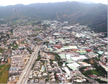
3.2.1.1
The PDA is located at south side of YLH and Yuen
Long New Town. As discussed above, the PDA comprises of 3 areas (i.e.
Area 1, Area 2 and Area 3). Other than the PDA, the Project also includes
a number of associated infrastructure consisting of works for roads, water
supplies and sewer pipes and a service reservoir outside the PDA. Figure 1.1 shows the locations of the 3 Areas and
associated infrastructure. The following sections provide an overview of
the existing environment of these areas and infrastructure.
Area 1
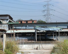
3.2.1.2
Area 1 is located in TYST and connected to the
YLH. Existing land uses are mixed with brownfield sites for various uses such
as open storage and rural industrial workshop, etc. Two concrete batching plants are located in
the northern part of Area 1 and some container storage sites are located in the
south-western part, along Long Hon Road, of the area. The structures within
these brownfield sites are mainly temporary structures of various forms.
3.2.1.3
Within Area 1, there are residential
developments along Sha Tseng Road and TYST Road such as Recours La Serre, The
Eldorado, Kisland Villa, etc. A non-indigenous village, Sha Tseng Tsuen, is
also located in Area 1. These residential developments are located away from
YLH and hence not badly affected by the highway’s traffic noise and vehicular
emission. All these residential developments in Area 1 are low density of
about 1 to 4 storeys but some of them are located very close to existing
brownfield sites and hence are affected by those brownfield operations to a
certain extent. Other than brownfield sites and low density residential
developments, there are also woodland and agricultural land with watercourses
of different sizes and qualities running
in between these existing developments. Some woodland is close to the Tai
Lam Country Park to the south west and forms a continuous resources in terms of
visual and ecology. There is also one graded historic building, i.e.
Yeung Hau Temple in TYST, within Area 1, which is culturally related to the
historical development of the indigenous villages.
|
|
|
Area
2
3.2.1.4
Area 2 is located to the east of Area 1 along Kung
Um Road and in the vicinity of Lam Tei East Road and Lam Tei West Road. There
are a number of brownfield sites with rural industrial uses such as warehouses,
open storage, vehicle maintenance, waste recycling, etc. A non-indigenous
village, i.e. Tin Lung Tsuen, is located in the northern part of this
area. The village is far away from YLH
and thus not badly affected by the highway’s traffic noise and vehicular
emission. The separation distance between some brownfield sites and
residential sites could be very close.
3.2.1.5
A number of village houses are built alongside
Kung Um Road and Kiu Hing Road overlooking onto Yuen Long Nullah. Some of these
houses are within a few metres from the existing road kerb line and adversely
affected by the road traffic noise and vehicular emission.
3.2.1.6
There is an active egretry near Pak Sha Tsuen
with small patches of secondary woodland located to the south of Area 2 outside
the PDA boundary. There are also a few
watercourses of different sizes and qualities within the PDA. Yuen Long
Nullah is running from south to north between Kung Um Road and Kiu Hing Road in
this area. No graded historic building
is present within Area 2.
3.2.1.7
There are one chicken farm and one pig farm
within Area 2. The nearest residential developments, Sun Mei Garden and Pak Sha
Tsuen, are outside the PDA but located only about 50-100m away from these
livestock farms. It is anticipated that these residential developments
would be affected by the odour from the operation of these livestock farms,
especially during hot summer time with unfavourable weather conditions.
|
|
|
Area 3
3.2.1.8
Area 3 is located south of Area 2 along Kung Um
Road, at the most southern part of the PDA. The area is densely built of
temporary structures for brownfield operation uses. Residential
developments include Pak Sha Tsuen, Golden Villa and Wong Nai Tun Tsuen, etc.
are located near the PDA and are mainly typical village houses of up to 3
storeys high. Yuen Long Nullah runs generally from south to north conveying
stormwater runoff from Tai Lam Country Park to the downstream receiving water
bodies. Yuen Long Nullah is an important visual element for the community
in the vicinity.
3.2.1.9
There are some
individual houses scattered in Area 3. A large piece of secondary woodland is present
to the western part of Area 3 and a few water courses of different
sizes and qualities are found within Area 3. Tai Lam Country
Park is located to the south of the area.
No graded historic building is present within Area 3.
3.2.1.10
There are currently two chicken farms and two
pig farms within Area 3. The nearest residential developments are at Wong Nai Tun Tsuen, Tai Tong Tsuen and
Pak Sha Tsuen at approximately 400m away from these livestock farms. Given
these four livestock farms are in the vicinity of the villages, it is
anticipated that these residential developments would be affected by the odour
from those livestock farms’ operation, especially during hot summer time with
unfavourable weather conditions.
|
|
|
Associated Infrastructure
3.2.1.11
There are supporting infrastructure / road
improvement works outside the PDA boundaries to support the proposed housing
development. New roads include slip roads for connection to Pok Oi Interchange
and a new PTI next to Yoho Midtown. The
slip roads will divert PDA traffic away from the busiest section of the YLH as
well as allow connectivity to West Rail Yuen Long Station. Improvement to existing road outside the PDA
include modification works to TYST Interchange and the TSWW Interchange for
enhanced connection to YLH, as well as some local road widening works to
improve road safety and pedestrian environment.
3.2.1.12
Besides road works, a new sewer would be
required to convey some of the TSE from the proposed YLS STW to the existing
inlet chamber of the NWNT tunnel at San Wai discharging to the Urmston Road
submarine outfall. This new sewer would run along the planned roads
within the YLS PDA and existing roads including Hung Tin Road, Ping Ha Road,
Tin Ha Road and Ha Tsuen Road outside the PDA.
3.3
Consideration
of Scenario Without the Proposed Development
3.3.1.1
Without the
Project, alternative housing sites may need to be identified on alternative
greenfield sites, which generally refers to previously undeveloped land. As mentioned in Section 3.1.2, in Hong Kong, land supply has been a subject
of concern for many years. In order to accommodate the increasing population
and household growth effectively, it would be more effective to develop on
previously developed land instead of looking for scarce greenfield land.
3.3.1.2
From urban
planning perspective, it is more effective to develop this area as it was close
to the well-established areas as well as new planned development areas such as Yuen Long New Town, Tin Shui Wai New Town and the future
HSK NDA. For Yuen
Long New Town in particular, it is a civic and commercial hub in Yuen Long
District with well-developed public transport infrastructures such as LRT
stations and MTR West Rail Stations. Tin Shui Wai New Town located to the
northwest of the YLS PDA, comprises a Wetland Park for various recreational and
educational purposes. The future HSK NDA is proposed to be developed to meet
long-term housing, economic, social and environmental needs. Summarizing the above,
the YLS PDA is located at an area which can create a synergy effect with these
new towns by better utilisation of existing facilities, and at the same time
providing future facilities to fulfil inadequacies and support future
development needs of the wider community.
3.3.1.3
Other
than supplying land for addressing territory-wide land supply, Stages 1, 2 and
3 of CE exercise conducted for this study have collated views and opinions
from various stakeholders. The CE exercise have also revealed a number of
aspirations from the local communities that cannot be fulfilled without implementing the Project,
including:
·
Road improvement works within the PDA such as Kung
Um Road and Kiu Hing Road which are mostly sub-standard;
·
Enhancement on the walking and cycling network and
the increase in provision of public transport at YLS;
·
Beautification and revitalisation measures for the
Yuen Long Nullah;
·
Upgrading works on the drainage and sewage
treatment facilities; and
·
Protection of natural resources within the PDA.
3.4
Recommended
Outline Development Plan
3.4.1.1
The RODP
adopted for this EIA Study is shown in Figure 3.1. The following sections present the design
principles and the key planning elements proposed in the RODP.
3.4.1.2
The planning of YLS has taken account of the
existing development characters and integration with Yuen Long New Town in its north
and the rural and natural landscape in the surroundings. The YLS development
would provide about 28,500 new flats for a total population of about
88,000. In line with the Long Term
Housing Strategy, the housing mix of 60% for public housing and 40% for private
housing is adopted. Economic uses
including commercial, storage and workshop uses have been planned for
employment opportunities. Together with the supporting infrastructure,
commercial, social and community facilities planned, the YLS development would
be developed as the new town extension for creation of a balanced community.
3.4.2
Key Planning
and Urban Design Principles
3.4.2.1
The overall
planning and urban design framework, which were adopted for the RODP, are
briefly described as below.
Accommodating
Diversity for Housing, Storage and Workshop, and Preservation of Natural and
Landscape Resources
3.4.2.2
Within the
PDA, 5 Planning Areas are proposed. Three residential communities are planned
with different development intensities taking account of the existing and
surrounding development characters. Each community is anchored with a key
activity node comprising of a PTI, and commercial and community uses. The Employment Belt is planned for storage,
industrial workshop and open storage uses, and is located at the northern part
of TYST close to the highway for easy access to YLH. The freight traffic would not need to travel
through the residential neighbourhood in the PDA. A Green Zone is designated at the southern
part of TYST to preserve the existing largest contiguous piece of active
farmland. Besides, watercourses of
higher ecological value and secondary woodland would also be preserved as far
as practicable.
Respecting
Existing Urban and Rural Environment by Stepped Building Heights
3.4.2.3
Through the
tapering of development intensities and building heights from north to south,
YLS will integrate with its surrounding settings by high density developments
in the north near Yuen Long New Town and transitioning to medium and
low-density developments in the south to blend in with the rural setting and
Tai Lam Country Park. Low-density developments are planned in the TYST area to
complement and integrate with existing low-density and low-rise residential
developments.
3.4.2.4
The urban to
rural qualities are further enhanced with the provision of Scenic Cycling
Tracks along the Hillside River Corridor and retaining active agricultural land
within the PDA. Bicycle parking
facilities are planned near the proposed PTIs, and a network of roadside cycle
tracks is widely available within the urban streetscape connecting the
residential neighbourhoods.
Blue-green
Network
3.4.2.5
The PDA is framed with a setting of natural and
rural environment together with the presence of various natural landscape and
watercourses. These resources form parts
of the urban structures for creating a liveable, sustainable and green
environment. These blue and green resources are combined to form the blue-green
network (the “blue” composed of watercourses
of higher ecological value, revitalised
nullahs and the new Hillside River Corridor and the “green” comprised of the
open space, the active agricultural land in the Green Zone, the secondary
woodland and the amenity areas). These features
are interwoven and integrated with the pedestrian and cycling track networks to
enhance the enjoyment of walking / cycling by providing rural and natural
landscape alongside. The blue-green network shapes and gives character and
identity of YLS.
3.4.2.6
The “blue” features provide opportunities for the
formulation of sustainable water management measures including the STW with tertiary treatment level, reedbed/
retention pond and flood retention facilities.
Creating Open
Space and Green Network
3.4.2.7
Open spaces of
various sizes and functions are planned and the residential communities will be
served with district open space. Together with the preserved active
agricultural land, secondary woodland, watercourses, as well as revitalised
nullahs and new water channels, all these will form a comprehensive green
landscape network to meet leisure and recreational needs while creating
identity and character for YLS. These features are integrated with each other
in the overall landscape framework.
3.4.2.8
Open space is
conveniently accessible not only for the future population but also existing
residents and villagers in and near the PDA.
Open space corridors (zoned “Local Open Space” (“LO”)) also function as
buffer between the existing low-rise villages and planned high-rise public and
private developments to address concerns of local villagers on the potential
wall effect due to new high rise developments. In addition, low-building areas
have also designated in the new residential areas next to existing villages.
3.4.2.9
A major Green
Zone is designated in the centre of the PDA by combining secondary woodland and
the largest piece of contiguous active agricultural land. This zone reflects
the rural characteristic of the area.
3.4.2.10
The backdrop
of Tai Lam Country Park also forms part of the green network through the
tapering of building heights, creation of visual corridors and linkages.
View Corridors
and Breezeways
3.4.2.11
When
formulating land use proposals, the view corridor at Yuen Long Park Aviary
Pagoda to the north of PDA has been considered. The gradation of development intensity and building
heights allow developments to optimise views to the mountainous
backdrop of the Tai Lam Country Park. Another key view corridor is along the
revitalised Yuen Long Nullah.
3.4.2.12
New roads
within the PDA are proposed to mainly align with the prevailing wind direction
as far as possible. Furthermore, stepping building height approach has been
adopted to help wind deflection and avoid air stagnation. The gradation of
building height profiles has been studied in relation to areas with different
plot ratios tapering downwards in the southbound direction.
Improving
Connectivity
3.4.2.13
The
connectivity of YLS with Yuen Long New Town and HSK NDA will be fully enhanced
through the planning of a new and comprehensive road, pedestrian and cycling
networks. Reserve has been provided in
the RODP for the potential extension of the environmentally friendly transport
services (EFTS) from the HSK NDA for providing efficient and comfortable
transport between the two developments.
Revitalisation of Nullahs
3.4.2.14
The existing
nullahs are key assets of the PDA and will be revitalised as far as practicable
to reach their full potential as an attractive asset of the PDA. The nullahs
will provide a rural and natural sensation in the urban context and act as key
north-south visual corridors.
3.4.2.15
In line with
recent advocacy for integrated green infrastructure systems and aspiration to
improve aesthetics and ecological value of the land, a green and eco-hydraulics
approach will be applied. A key consideration is to improve aesthetic whilst
maintain and compensate for the hydraulic performance of the channel. Some of the green and eco-hydraulics
approaches which will be considered are:
·
Using
grasscreting and extensive vegetation embankment, e.g. nullahs in Jordan Valley
and Tsui Ping;
·
Using gabions and
geo-fabric reinforced grass lining, e.g. Yuen Long Bypass Floodway;
·
Using unlined
channel beds such as rip-rap base and retaining meanders, e.g. Kam Tin River,
Shan Pui River and Ng Tung River; and
·
Creating
shallow ponds, wetland habitats and reedbeds, e.g. Yuen Long Bypass Floodway
and San Tin.
Preservation of Egret Flight Path
3.4.2.16
The active
egretry near Pak Sha Tsuen is an important ecological asset to the PDA. The
design of RODP has considered the preservation of egrets’ flight path.
3.4.2.17
A 90m to 135m wide district open space is
designated between sites R2.6a, R2.6b and R2.6c to protect the
flight corridors of the egrets, which may be impeded by the residential
buildings, by retaining the green linkage to the exiting foraging round at
retained farmland at Shan Ha Tsuen.
3.4.2.18
An about 50m wide non-building area (NBA) is
designated at Sites R2.6d to protect the fight path in East-to-West direction
with the proposed new foraging ground at Retention Lake.
3.4.2.19
A 30m wide NBA
is designated between the two “R2(SSF)c” sites and a Low building area (LBA) is
also designated at the northeast corner of site OU3.2a to protect the flight
path in north-to-south direction and to provide a flight corridor leading to
the fully revitalised Yuen Long Nullah at the southern end of PDA.
3.4.3
Key
Development Parameters and Land Use Budget
3.4.3.1
The current
development proposals constitute residential use, storage and workshop uses,
government, institution or community (GIC) use, as well as agriculture, open
space, amenity and green belt. The land use budget of the RODP is summarized in
the following table and the development parameters for the PDA are set out
below:
Table 3.1 Key development
parameters under RODP
|
Total
Population |
About 88,000 (including the population of about 2,400 of the existing/planned residential estates and
non-indigenous villages that are proposed to be retained) |
|
Population (new) |
85,400 |
|
No. of Flat (new) |
28,500 |
|
Housing Mix |
|
|
·
Housing Units |
Public 61% : Private 39% |
|
·
Population |
Public 62% : Private 38% |
|
·
Housing Land |
Public 32% : Private 68% |
|
Plot Ratio for Residential |
|
|
·
Public |
4 and 5 |
|
·
Private |
1,
1.5, 2.4, 4 and 5 |
Table 3.2 Land
Use Budget
|
Land Use |
Proposed Zoning on RODP |
Area (ha) (% of total) |
|
(A) Residential |
72.5(32.4%) |
|
|
-
Subsidised
Housing |
“RSc”, “R1(SSF)c”, “R2(SSF)c” |
18.9 |
|
-
Private Housing
|
“R1c”, “R2c”, “R2”, “R3”, “R4”, “R5”, “R5(EDA)” |
46.3 |
|
-
Village Resite |
“R6” |
1.3 |
|
-
Other Specified
Uses (Mixed Use) |
“OU(MU)” |
5.9 |
|
(B) Storage and Workshop |
11.1 (5%) |
|
|
-
Other Specified
Uses (Open Storage) |
“OU(OS)” |
1.4 |
|
-
Other Specified
Uses (Storage Use) |
“OU(SU)1”, “OU(SU)2” |
8 |
|
-
Other Specified
Uses (Storage and Workshop) |
“OU(S+W)” |
1.7 |
|
(C) Government, Institution or
Community |
10.2 (4.5%) |
|
|
-
Government |
“G” |
9.2 |
|
-
Institution or
Community |
“IC” |
1 |
|
(D) Education |
“E” |
5.7 (2.6%) |
|
(E) Public Utilities(1) |
15.3(6.8%) |
|
|
Other Specified Uses (Sewage Treatment Works) |
“OU(STW)” |
4.0 |
|
Other Specified Uses |
“OU” |
1.1 |
|
Other Specified Uses (Hillside River Corridor with Scenic Cycle Track) (4) |
“OU(Hillside River Corridor with Scenic Cycle Track)” |
10.4 |
|
(F) Road and River Channels |
|
53.5(22.2%) |
|
(G) Amenity |
“A” |
6.5(2.9%) |
|
(H) Open Space |
28.6(12.8%) |
|
|
-
District Open
Space |
“DO”, “DO(1)” |
15.7 |
|
-
Local Open
Space |
“LO”, “LO(1)” |
12.9 |
|
(I)
Agriculture(2) |
“AGR” |
10.5(4.7%) |
|
(J)
Green Belt(3) |
“GB”, “GB(1)” |
9.6 (4.3%) |
|
(K) Village Type Development |
“V” |
0.1(0.04%) |
|
Grand Total |
|
223.5 |
Notes:
(1) “OU(Service Reservoir)” (about 0.6ha) is outside the PDA boundary
(2) “AGR” zones include the preserved active
agricultural land and one existing chicken farm located at the southern end of
Kung Um Road.
(3) “GB” zones cover the preserved
ecologically important areas including secondary woodland, watercourses of
higher ecological value and buffer areas.
(4) “OU (Hillside River Corridor) with Scenic
Cycle Track” also includes reedbed/retention pond.
3.4.4
Residential
3.4.4.1
Under the RODP, the approximate 28,500 new
residential will house an estimated new population of approximately 85,400
persons. With the existing population within the Project Area, the overall
population is projected to be around 8,8000 persons upon full development. The
public to private housing mix is about 61:39.
3.4.5
Storage and
Workshop
3.4.5.1
Taking
advantage of the close connection with the highway network, about 11.1 ha of
land at the south of YLH in the PDA at TYST area for storage and workshop uses.
Through modifying the TSWW and TYST Interchanges particularly the former, more
traffic movements are allowed to cater for direct access of freight traffic to
YLH. These sites will provide about 389,000 GFA for storage and workshop uses
and reserved about 1.4ha for open storage uses.
3.4.6
Government
3.4.6.1
“Government”f (“G”) zones are intended for the provision of
G/IC facilities such as police station, fire station, hospital, sports centre,
social welfare building, etc, serving the needs of the local population of
about 88,000 and complementing provisions in the wider area of TYST and Tai
Tong. It is also intended to provide
land for uses directly related to or in support of the work of the Government
or organisations that provide social services to meet community needs.
3.4.7
Institution or
Community
3.4.7.1
Three sites ( Site G1.1, 1.3 and 1.4) are
designated as “Institution or Community” (“IC”) on the RODP to preserve the
existing religious institutions
3.4.8
Education
3.4.8.1
Schools will be provided within the “Education”
(“E”) zone within the Project area. In general, developments at these sites are
subject to a maximum building height of 8 storeys.
3.4.9
Public
Utilities
Other Specified Uses (Sewage Treatment Works) (“OU(STW)”)
3.4.9.1
An “OU(STW)”
zone (Site OU3.3, at the southern end of Kung Um Road is reserved for
the construction of an aboveground STW for treatment and disposal of sewage
arising from the PDA. A reedbed/ retention pond with an area of
around 4ha is proposed adjacent to the “OU(STW)” zone to provide biological
treatment and TSE polishing, subject to further detailed study. It is intended
to minimise the pollution loading being discharged from the YLS
development. Due to the uncertain pollution removal efficiency of the reedbed,
its polishing function would only be regards as an extra provision and would
not be considered in the pollution load offset balance as stated in Chapter 7. Reuse of TSE as reclaimed water for non
portable use including toilet flushing would be implemented in the PDA and
existing and future developments.
Other Specified Uses (Refuse Collection Point and Sewage Pumping
Station) (“OU(RCP&SPS)”)
3.4.9.2
Two “OU(RCP&SPS)” zones (Sites OU1.12
and OU2.2) are intended for the sewage pumping stations (SPS) and
refuse collection points (RCP).
Other Specified Uses (Electricity Substation) (“OU(ESS)”)
3.4.9.3
Site OU2.1
(site area of about 0.3 ha) is intended for the construction of an Electricity
Substation.
Other Specified Uses (Service Reservoir) (“OU(Service Reservoir)”)
3.4.9.4
Site OU1.12
(site area of about 0.6 ha) located to the south of the PDA at TYST area is
intended for a potential reclaimed water service reservoir.
Other Specified Uses (Hillside River Corridor with Scenic Cycle Track)
(“OU(Hillside River Corridor with Scenic Cycle Track)”) – 9.8ha
3.4.9.5
About 10 ha of
land along the western boundary of LOHAS
Living is zoned “OU(Hillside River Corridor with Scenic Cycle Track)”,
including land for reedbed/ retention pond. In order to mitigate the impact of
additional surface runoff generated from the proposed development, the new
drainage channel is proposed for water storage as well as its normal drainage
function, which also provides opportunity for ecological enhancement. A scenic
cycle track, footpath and landscaping are proposed alongside the drainage
channel for public enjoyment.
3.4.10
Amenity
3.4.10.1
This zone is reserved
along developments, roads and YLH to allow provision of roadside planting,
buffer and footpath to enhance the environment and to serve as visual buffers.
3.4.11
District Open Space
3.4.11.1
A number of
“DO” are planed within the Project area to provide recreational and leisure
spaces. “DO” is intended primarily for the provision of outdoor open-air public
space for active and/or passive recreational uses serving the needs of local
residents as well as the general public. A network of district and local open
space will create a naturalistic environment and green setting of the whole
area. The DO sites will also serve as the flight corridor to protect the
egrets’ flight path.
3.4.12
Local Open Space
3.4.12.1
Local Open
Space” (“LO”) is provided throughout the Project area and is in close proximity
to residential areas and employment centres to serve local residents and
workers.
3.4.13
Agriculture
3.4.13.1
This zone is
intended primarily to retain and safeguard existing quality agricultural land
for agricultural purposes. The southeastern portion of TYST is predominately
dry active agricultural land intermixed with wet and inactive agricultural
land. This area is designated as “AGR” to allow the continuation of farming
practices. The retained chicken farm at the southern end of the PDA is also zoned “AGR” (site AGR 3.1).
3.4.14
Green Belt
3.4.14.1
The planning
intention of these zones is primarily for defining the limits of urban and
sub-urban development areas by natural features and to contain urban sprawl.
There is a general presumption against development within these zones.
3.4.14.2
Three land
corridors adjoining the streams
with ecological importance within the PDA are zoned “GB(1)” which intend to
protect the habitats for wildlife from unauthorized encroachment and illegal
dumping, while providing flexibility to the Town Planning Board to scrutinise
developments under the planning permission system.
3.4.15
Village Type Development
3.4.15.1
The planning
intention of “V” zone on RODP is mainly to retain existing houses at the
boundary of PDA.
3.4.16
Road and River Channels
3.4.16.1
The road
network consists of vehicular lanes, pedestrian footpaths, road-side amenity,
cycle tracks, and road reserve for an EFTS, which would subject to further
studies. A simple hierarchy of vehicular lanes is proposed to serve the PDA
efficiently without resulting in excessively wide roadways.
3.4.16.2
A continuous
cycle track designated as “Road” has been proposed along proposed residential
developments in Area 2 to link with the cycle track network along the road.
3.4.16.3
There are
three existing drainage channels within the PDA, namely Yuen Long Nullah, Tin
Tsuen Channel and Yuen Long West Nullah, and decking of these channels would be
avoided as far as practicable. Through revitalisation, these channels would
provide a landscaped and pleasure walking environment for the community. In
particular, the northern section of Yuen Long Nullah within Area 2 is proposed
to be partially decked to provide adequate road space with potential for nullah
revitalisation.
3.5
Proposed Construction Methodologies for Land Uses
and Design
3.5.1
Site Formation
3.5.1.1
The site
formation is to be carried out by phases.
The order of magnitude of the inert Construction & Demolition
(C&D) soft material generated from slope cut and formation is similar to
the general fill formation required for design flood level. The fill material would be reused within the
Project as far as practicable.
Conventional earthwork cut and fill machineries will be used for the
site formation.
3.5.1.2
Near the
hillside, larger-scale slope cut and retaining wall is required to maximise the
available land for development. At these
locations, construction like soil nail installation and reinforced concrete
retaining wall with temporary slope cut will be involved. At constrained locations, cantilever
retaining wall like bored pipe wall is needed.
This will be achieved by piling machinery.
3.5.2
Road Works and
Utilities
3.5.2.1
The proposed
road works and utilities include road networks, drainage systems, sewerage
networks, water supply networks and utility construction to support the
development in the new development area.
3.5.2.2
Except for the
grade-separated interchanges, typical construction method for at-grade road
construction would be adopted. The works involve earthworks, utilities laying,
laying of sub-base materials and laying of bituminous or concrete surfacing
layers.
3.5.3
Bridge
Structures at Interchange
3.5.3.1
The
substructures of the bridge structures at the interchanges will take the form
of reinforced concrete (RC) columns & pile caps founded on RC bored piles.
3.5.3.2
Regarding
superstructure, given the small total length, sharp road curves and complicated
geometry of the bridge structures, it is envisaged that precast segmental
construction and in-situ balanced cantilever will not be cost-effective and
appropriate for this particular condition.
Conventional in-situ bridge construction on formwork and falsework, with
appropriate temporary traffic management, is envisaged to be adopted. The superstructure will take form of typical
RC structures.
3.5.4
Underpass at
Interchange
3.5.4.1
Cut-and-Cover
method would be adopted for the underpass, which involving trench-excavation
(i.e. open-cut) followed by in-situ construction of the tunneCHANNl structures.
3.5.5
Box Culvert /
Bridge Crossing at Channel
3.5.5.1
Cut-and-Cover
method would be adopted for the box culvert.
The construction will have to be carried in particular seasons with less
disturbance to the drainage flow.
Temporary drainage arrangement will also be developed during the
construction to avoid impact to the drainage.
3.5.6
Landscaping
Works at Open Spaces, Amenity Areas and Slopes
3.5.6.1
Landscaping
works at open space, amenity areas and slopes will be provided after site
formation works and slope works. As these will mainly involve planting and
minor pedestrian facilities, environmental impact is not anticipated.
3.5.7
Reclaimed
Water Service Reservoir
3.5.7.1
The major
construction works will include typical earthwork, concrete works for service
reservoir structures, pipeworks and modification work to existing access road.
Both cut-and-fill slopes shall be formed for the formation of platform for the
service reservoirs construction and for the modification work to existing
access road.
3.5.8
Noise
Barriers/ Enclosures
3.5.8.1
Depending on
the ground condition, the noise barrier/ enclosure height and the site
constraint, the noise barrier/ enclosure will either be supported on shallow
foundation or on piles. The noise panel
is usually pre-fabricated and erected on site with appropriate temporary
traffic management.
3.5.9
Building
3.5.9.1
The building
in the new town will be constructed by the Housing Department, the
Architectural Services Department or the private developers, depending on the
building type and land use. It is
envisaged that conventional building construction will involve piling work. For the superstructure, either precast block
erection or in-situ concreting work is envisaged.
3.5.10
Sewage
Treatment Works/ Sewage Pumping Stations
Sewage Treatment Works
3.5.10.1
A new YLS STW will be provided to handle the
sewage arising from the new population and employment in the PDAs. The new YLS
STW will be implemented in two phases to serve the different phases of
development.
3.5.10.2
The new YLS STW (Phase 1) will start operation
in Year 2030 to handle 1,800 m3/day of sewage generated in the YLS
Stage 1. The new YLS STW (Phase 2) will be expended to cope with the flow in subsequent
stages, subject to review of the future population growth. The new YLS STW will
be constructed with tertiary treatment for reuse of reclaimed water and
secondary plus treatment (with UV disinfection and 75% nitrogen removal) for
disposal of effluent with an ultimate design capacity of approximately 24,000 m3/day.
3.5.10.3
The proposed YLS STW is a DP under Schedule 2.
DP requiring EPs. Hence separate EIA Study for the proposed STW will be conduct
by the future project proponent. Further details can be extracted in the
Chapter 7 – Sewage and Sewerage Treatment.
Sewage Pumping Stations
3.5.10.4
The sewerage arrangement for the intermediate
and ultimate development stages, include two intermediated SPSs which will be
required to convey the sewage to new YLS STW. The two new SPSs will be
implemented with pump capacity of 304 l/s located at the eastern side of TYST
to pump the sewage collected in TYST to the eastern side of the PDA along Kung
Um Road and pump capacity of 1,508 l/s located adjacent to Lung Tin SPS to pump
the sewage to the YLS STW for treatment.
3.5.10.5
Construction of two intermediated SPSs will be
carried out in the stage 2 in order to cope with the completion of stage 2
works for the Project.
3.5.10.6
Since these two SPSs are with an installed
capacity of more than 2,000 m3/day and are located within 150 m from
existing and/or planned residential area or educational institution, these SPSs
are classified as DPs under Item F.3, Part 1, Schedule 2 of the EIA Ordinance.
3.5.11
Revitalisation
of Nullahs
Partial Decking and Revitalisation of
Yuen Long Nullah
3.5.11.1
Partial decking and revitalisation of the Yuen
Long Nullah will be provided along Kung Um Road and Kiu Hing Road to meet the
traffic needs and as part of the urban design initiative for the YLS PDA, but
it will reduce the capacity if the Yuen Long Nullah by reducing flow area and
increase the roughness surface. A new drainage system that runs parallel
with the Yuen Long Nullah is proposed (e.g. box culverts underneath Kung Um
Road and Kiu Hing Road) to compensate the reduction flow areas and nullah
capacity such that the concerned section of Yuen Long Nullah can still provide
50 year conveyance capacity. This portion of Yuen Long Nullah within YLS PDA
will be provided greening and eco-hydraulics approach for rehabilitating the 12m
to 16m wide trapezoidal concrete-lined Yuen Long Nullah (some 2.5km long).
Revitalisation of Existing Yuen Long
(West) Nullah and Tin Tsuen Channel
3.5.11.2
As part of the urban design initiative, sections
of the existing Yuen Long (West) Nullah and Tin Tsuen Channel, are proposed to
be revitalised by various soft and hard landscape treatment proposals.
Human access down to the revitalised channel is not proposed due to the
inherited flood risk.
3.5.11.3
In line with the recent advocate of integrated
green infrastructure system and aspiration to improve aesthetics and ecological
value of the land, it is proposed to convert and rehabilitate the 9m wide
rectangular concrete-lined Tin Tsuen Channel (some 1.5km long) and 11m wide
trapezoidal concrete-lined Yuen long (West) Nullah (some 0.5km long).
Similar to the Yuen Long Nullah, the Tin Tsuen Channel and Yuen Long (West)
Nullah green and eco-hydraulics approach will be applied.
3.5.11.4
In addition, reference shall be made to DSD “Practice
Note No. 1/2015 – Guidelines on Environmental and Ecological Consideration for
River Channel Design” to tally with the concept of revitalising water-friendly
culture in large-scale drainage improvement works and planning drainage
networks for YLS PDA, so as to build a better environment for the public and
balance between flood protection and ecological conservation.
3.5.12
Retention
tank, Retention lake, Hillside River Corridor and Reedbed/ Retention Pond
3.5.12.1
The construction works include excavation of
underground retention tank could be constructed by cut and cover method with
associated shoring system, and the retention lake/ hillside river corridor as
well as the reedbed/ retention pond could be constructed by open-cut
method. The adopted construction methods are depended on the site
constrains during the construction stage, which will be subject on various
factors, such as topography and geology, etc. During the construction stage,
the Contractor should require to provide any measures, such as sand traps, silt
traps, sediment tanks, septic tanks, and soakaway system, etc, and get
discharge licence from relevant authorities to ensure the surface runoff and
sewage from construction activities do not cause adverse impact to the water
bodies.
3.6
Consideration of Alternative Construction
Methodologies
3.6.1
Alternative for
Site Formation Levels
3.6.1.1
A
majority of the PDA is on the Yuen Long Plain at approximately +5mPD, with
elevation increasing in proximity to the mountain range with a maximum
elevation of +56mPD. The site formation for the PDA will keep as close to the
existing ground profile as possible. The accesses of the exiting village and
the new development area will be considered to match the new infrastructure
level.
Option 1: PODP Site Formation
3.6.1.2
In the
preliminary site formation design based on the PODP, quantity of excavated
material is greater than the required quantity of fill material which requires
net export of a large amount of C&D material from the YLS development
project.
Option 2: RODP Site Formation
3.6.1.3
Later in the amended site formation design based
on the RODP, design refinement has been made in the cut and fill volume
balancing. Particularly in phase 2, the site formation level is slightly raised
to provide higher defence of flooding protection against climate change, while
maximising the on-site reuse of fill material.
3.6.1.4
The
comparison of cut and fill material generation for the PODP and RODP site
formation designs are tabulated in Table
3.4 below and the site formation layout plan for PODP and RODP are illustrated
in Appendix
3.1
3.6.1.5
It can be seen that the Option 2 adopted has
less surplus C&D waste material and hence is more environmentally friendly
in term of waste disposal. It also
slightly reduces the construction traffic to dispose of the surplus material.
Table 3.4 Comparison of
Cut and Fill Material Generation for PODP and RODP Site Formations
|
Material |
In-situ Volume (m3) |
|
|
Option 1: PODP Site Formation |
Option 2: RODP Site Formation |
|
|
Cut |
1,690,000 |
1,620,000 |
|
Fill |
1,580,000 |
1,540,000 |
|
Cut minus Fill |
110,000 |
80,000 |
3.6.2
Alternatives for TSWW Interchange
Improvement Option 1
3.6.2.1
The
layout of TSWW Interchange Improvement Option 1 is presented on Appendix
3.2. In this option, the main objective of the improvement work is to
provide a local road connection between the Tin Shui Wai / Hung Shui Kiu areas
and the YLS PDA via Hung Tin Road. There is no direct slip road connection
between the YLS PDA and the YLH in this option.
However vehicles from / to YLS PDA can indirectly U-turn at the diamond
interchange on Hung Tin Road at the north and access to the YLH.
3.6.2.2
The
off-slip road from YLH westbound to Tin Shui Wai has to be realigned to a
depressed road / underpass, so as to provide grade separation with the local
connection road between Tin Shui Wai and YLS. A signalised junction is proposed
at the south to serve as the junction between local distributors Roads L11, L20
& L22 and Hung Tin Road.
Improvement Option 2
3.6.2.3
The
layout of TSWW Interchange Improvement Option 2 is presented on Appendix
3.2. In this option, in addition to providing a local road connection
between the Tin Shui Wai / Hung Shui Kiu areas and the YLS PDA, the design
objective is to provide direct slip road connections between the YLS PDA and
the YLH. The planning concept is to encourage part of the heavy vehicles in
Zone 1 to access YLH via TSWW Interchange and hence minimising through traffic
to the residential areas at the east.
3.6.2.4
Despite
this, it is acknowledged that converting a 3-leg trumpet interchange to a 4-leg
full-cloverleaf interchange serving 3 new towns would involve much significant
land and cost. The location is
impractical to house a full-colverleaf interchange. The design of improvement option 2 therefore
only focuses on the connectivity with YLH westbound.
3.6.2.5
For
traffic on YLH eastbound, it can access YLS PDA either via a U-turn at the
diamond interchange on Hung Tin Road, or via the TYST Interchange further
downstream. The design of the TYST
Interchange Improvement Works is also taking this factor into account.
3.6.2.6
For
traffic on YLH westbound, additional bifurcating ramps are added to allow the
traffic to access an at-grade roundabout.
The at-grade roundabout provides connection between YLS Roads L11, L20
and L22, Hung Tin Road and YLH westbound.
There are five arms to this junction and hence a roundabout instead of a
signalised junction is more appropriate.
3.6.2.7
In
order not to avoid the free flow of the traffic to the Tin Shui Wai direction,
the off-slip road from YLH westbound to Tin Shui Wai is realigned to a
depressed road / underpass, so as to provide grade separation with the at-grade
roundabout. This bypass slip road
involves a new underpass structure beneath YLH to be constructed via
lane-by-lane temporary traffic management scheme. The continuously covered section of the slip
road is limited to below 230m.
3.6.2.8
Segregated
left-turning lane is also proposed on the roundabout to provide free flow of
the on-slip road from Tin Shui Wai to YLH westbound.
3.6.2.9
A
footbridge is proposed above the at-grade roundabout to provide pedestrian and
cyclists connection between different sides of the roundabout and link up with
the Tin Shui Wai / Hung Shui Kiu areas.
A subway is not recommended as the level will be in conflict with the
proposed underpass.
3.6.2.10
The
level of the at-grade roundabout has to be tie-in with slip roads with YLH and
the roundabout footprint has to be relatively flat. As such the junction level of Improvement
Option 2 is lower than that in Option 1 and much lower than the existing ground
level. The levels of the Roads L20 and
L22 and nearby site formation also have to be lower. It is highlighted that the improvement option
2 will require relatively more site formation works, land requirement and cost,
as compared to Option 1.
3.6.2.11
Recommended Option
3.6.2.12
Despite
the higher cost and land requirement of Improvement Option 2, there is a strong
planning and environmental objective to minimise the through traffic the
residential areas in YLS PDA. Relatively
less site formation work and less land requirement are involved in this
improvement option, as compared to Option 2. As such, Option 2 is more suitable
in term of new town planning concept and traffic noise mitigation.
3.6.2.13
In
addition Option 2 offers a secondary access to the YLS PDA. A backup access point is beneficial in term of
traffic planning. The improved TSWW
Interchange can share the traffic burden to the TYST Interchange. Option 2 is
more suitable in traffic noise mitigation by diverting through heavy good
vehicle traffic away from the residential areas in YLS PDA.
3.6.2.14
Improvement
Option 2 is therefore recommended for further development.
3.6.3
Alternatives for
Tong Yan San Tsuen Interchange
3.6.3.1
Improvement Option 1
3.6.3.2
The
layout of TYST Interchange Improvement Option 1 is presented on Appendix
3.3. In this option, the slip roads are reconfigured
to provide full-movement connectivity between Long Tin Road, proposed YLS PDA
and YLH. The existing slip roads with
Long Tin Road are maintained or realigned.
New slip roads are added to connect with the proposed Road D1.
3.6.3.3
The
improvement works involve a new underpass structure beneath YLH to be
constructed via lane-by-lane traffic management scheme and several new elevated
viaduct structures. Several existing
bridge and underpass structures are to be abandoned and demolished.
3.6.3.4
The
existing slip road are in tight radii of curvature. In the improvement works, the radii will be improved
to at least the absolute values under current standard. However since there is land constraint
surrounding the interchange, adoption of below-desirable radii is
required. It is highlighted that the
adopted radii of curvature are still better than the existing conditions.
3.6.3.5
The
off-slip ramp from YLH eastbound is relocated westward. Headroom above TYST Road is maintained.
3.6.3.6
Lam
Yu Road has to be diverted to provide space for 2-lane on-slip merging to YLH.
3.6.3.7
Improvement Option 2
3.6.3.8
The
layout of TYST Interchange Improvement Option 2 is presented on Appendix
3.3. This option shares similar layout and design with Option 1. The exception is that a slip road from TYST
Interchange to Road L11 is added. The
bypass slip road goes beneath the on-slip ramp to YLH westbound in the form of
depressed road and underpass structure.
3.6.3.9
The
additional slip road provides a direct connection from YLH eastbound and
westbound to Zone 1 Road L11. This helps
in diverting heavy vehicles of logistics / industrial use away from the
residential areas in Zone 2.
3.6.3.10
A
direct connection from Zone 1 to YLH eastbound is not provided due to conflict
with other more important slip roads.
The traffic from Zone 1 can either enter YLH eastbound via the diamond
interchange in Hung Tin Road to TSWW Interchange or via Road D1 to TYST Interchange.
3.6.3.11
Recommended Option
3.6.3.12
The
addition of the bypass slip road to Road L11 involves addition cost, but better
fulfil the planning intension to divert heavy vehicles away from residential
areas. The additional cost is relatively
small compared to the overall capital cost.
Option 2 is better in term of planning and it is more suitable in
traffic noise mitigation by diverting through heavy good vehicle traffic away
from the residential areas in YLS PDA.
3.6.3.13
Improvement
Option 2 is recommended for further development.
3.7.1.1
It is anticipated that the new town development
will be commissioned in phases. The construction works is targeted to commence
in Year 2020 and are summarised in Table 3.5 below.
Table
3.5 Works Packaging for the YLS Development
|
Works Package |
Land Clearance & Construction Period |
Description of Works |
|
Stage 1 Works - Phase 1a) Initial Housing Site / Road
Improvement Works |
2020 to 2027 |
·
Decontamination and Site Formation Works ·
Internal Road, Pipe works and Landscaping ·
Nullah Decking and Road Works for Kung Um Road/Kiu Hing Road and New
Local Distributor to Tai Kei Leng Rd |
|
Stage 1 Works - Phase 1b) Initial Housing Site / Resite
Village House |
2020 to 2029 |
·
Decontamination and Site Formation Works ·
Internal Roads, Pipeworks, Utilities and Landscaping ·
Re-site Village House Construction (Zone 1 and Zone 2) ·
Construction of Public Housing |
|
Stage 2 Works - Phase 2a) Multi-Storey Building/ Open Storage
Site (To the South West of TSWW Interchange) |
2022 to 2028 |
·
Decontamination and Site Formation Works ·
Internal Roads, Pipeworks, Utilities and Landscaping ·
Construction of Multi-storey Buildings ·
Preparation of Open Storage Site |
|
Stage 2 Works - Phase 2b) Northern Sites along Kung Um Road,
Kung Um Road Improvement and Reclaimed Water Service Reservoir |
2023 to 2033 |
·
Decontamination and Site Formation Works ·
Internal Roads, Pipeworks, Utilities and Landscaping ·
Tin Tsuen Channel Revitalisation ·
Kung Um Road/Kiu Hing Road/Wong Nai Tun Tsuen Road Improvement/ Yuen Long
Nullah Revitalisation and Landscaping ·
Reclaimed Water Service Reservoir and Service Road ·
Re-site Village House Construction ·
Tin Tsuen Channel Revitalisation ·
Construction of Private Housing ·
Construction of Public Housing ·
Construction of Government Facilities |
|
Stage 2 Works - Phase 2c) External Roads (Tong Yan San Tsuen
Interchange Improvement, Shap Pat Heung Interchange Improvement) |
2025 to 2032 |
·
Decontamination and Site Formation Works ·
TYST Interchange Improvement and Landscaping ·
Yuen Long West Nullah Revitalisation ·
Re-site Village House Construction (in Zone 3) ·
Shap Pat Heung Interchange Improvement and Landscaping |
|
Stage 2 Works - Phase 2d) Sewage Treatment Works |
2023 to 2029 |
·
Decontamination and Site Formation Works ·
Sewage Treatment Works ·
Pumping Station |
|
Stage 2 Works - Phase 2e) Multi-Storey Buildings (Remaining) |
2025 to 2033 |
·
Decontamination and Site Formation Works ·
Internal Roads, Pipeworks, Utilities and Landscaping ·
Construction of Multi-storey Buildings |
|
Stage 3 Works - Phase 3) Southern Sites Along Kung Um Road,
Kung Um Road Improvement |
2031 to 2038 |
·
Decontamination and Site Formation Works ·
Internal Roads, Pipeworks, Utilities and Landscaping ·
Hillside River Corridor & Retention Lake ·
Construction of Private Housing ·
Construction of Public Housing ·
Construction of Government Facilities |
|
Stage 4 Works - Phase 4a) Sites in Tong Yan San Tsuen and
Internal Roads |
2032 to 2038 |
·
Decontamination and Site Formation Works ·
Internal Roads, Pipeworks, Utilities and Landscaping ·
Retention Tank/Lake ·
Construction of Private Housing ·
Construction of Government Facilities |
|
Stage 4 Works - Phase 4b) TSWW Interchange Improvement |
2032 to 2038 |
·
Decontamination and Site Formation Works ·
TSWW Interchange Improvement and Landscaping |