Contents
Reference: ESB-146/2006 Issue 2, March 2009
Executive
Summary
Environmental
Monitoring & Audit Manual
Environmental Monitoring
& Audit Manual
Main
Text
1.1 Background
1.2 Renewable Energy: The Need for the Project
1.3 Overview of Global Wind Energy
1.4 Stakeholder Consultation for the Proposed Project
1.5 EIA Study Objectives
1.6 EIA Study Report Structure
2.1 Project Components
2.2 Site Selection Process
2.3 Site Selection Results
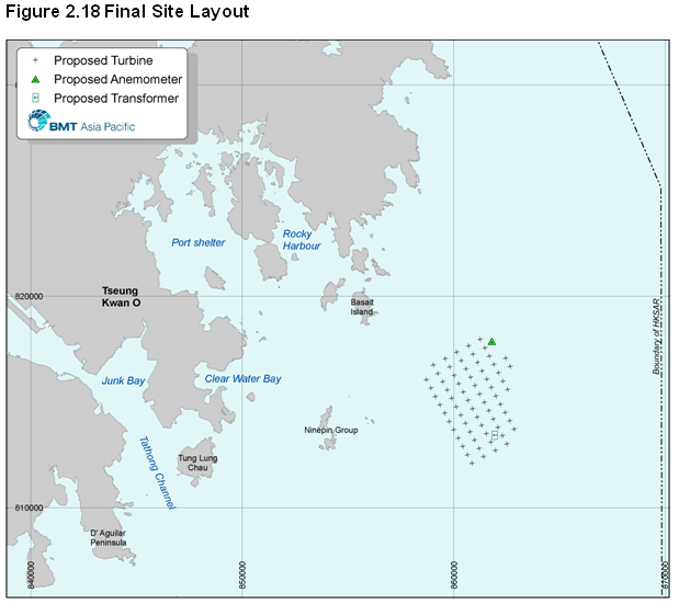
2.4 Site Refinement and Layout
2.5 Transmission Cable Routing
2.6 The Baseline Site and Alternative Site Design
2.7 Construction Options and Method Selection
2.8 Installation of Components
2.9 Construction Program
2.10 Offshore Construction Logistics
2.11 Operations and Maintenance
2.12 References
3 Waste & Materials Management
3.1 Introduction
3.2 Objectives
3.3 Legislation, Standards & Guidelines
3.4 Waste Management Impact Assessment
3.5 Mitigation of Adverse Impacts
3.6 Assessment of Residual Impacts
3.7 Environmental Monitoring and Audit
3.8 Conclusion
3.9 References
4 Water Quality Impact Assessment
4.1 Introduction
4.2 Objectives
4.3 Legislation, Standards and Guidelines
4.4 Assessment Approach
4.5 Baseline Conditions
4.6 Evaluation Criteria
4.7 Construction Phase Impact Assessment
4.8 Operational Phase Impact Assessment
4.9 Impact Mitigation
4.10 Residual Impact Assessment
4.11 Environmental Monitoring & Audit Requirements
4.12 Conclusions & Recommendations
4.13 References
5.1 Introduction
5.2 Objectives
5.3 Legislation, Standards & Guidelines
5.4 Assessment Approach
5.5 Ecological Baseline Profile – Literature Review
5.6 Field Survey Results
5.7 Construction Phase Impact Assessment
5.8 Operational Phase Impact Assessment
5.9 Cumulative Impacts
5.10 Mitigation Measures & Best Practice
5.11 Residual Impact Assessment
5.12 Environmental Monitoring & Audit Requirements
5.13 Conclusions & Recommendations
5.14 References
6.1 Introduction
6.2 Objectives
6.3 Legislation, Standards & Guidelines
6.4 Assessment Approach
6.5 Ecological Baseline Profile
6.6 Construction Phase Impact Assessment
6.7 Operational Phase Impact Assessment
6.8 Mitigation Measures & Best Practice
6.9 Residual Impact Assessment
6.10 Environmental Monitoring & Audit Requirements
6.11 Conclusions & Recommendations
6.12 References
7.3 Legislation, Standards & Guidelines
7.5 Baseline Conditions and Sensitive Receivers – Desktop Study
7.6 Baseline Conditions and Sensitive Receivers – Field Surveys
7.7 Construction Phase Impact Assessment
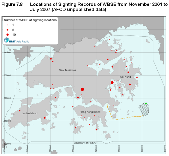
7.8 Operation Phase Impact Assessment
7.9 Mitigation & Best Practices Measures
7.10 Environmental Monitoring & Audit
7.11 Conclusions & Recommendations
7.12 References
8.3 Legislation, Standards & Guidelines
8.5 Fisheries Baseline – Literature Review
8.6 Fishery Baseline – Field Surveys
8.7 Construction Phase Impact Assessment
8.8 Operational Phase Impact Assessment
8.10 Mitigation Measures & Best Practice
8.11 Residual Impact Assessment
8.12 Environmental Monitoring & Audit Requirements
8.13 Conclusions & Recommendations
8.14 References
9.3 Legislation, Standards & Guidelines
9.7 Evaluation of Baseline Marine Archaeological Potential
9.8 Construction Phase Impact Assessment
9.9 Operation Phase Impact Assessment
9.10 Impact Mitigation and Best Practice Measures
9.12 Environmental Monitoring & Audit
9.13 Conclusion & Recommendations
9.14 References
10.2 Legislation, Standards & Guidelines
10.4 Review of Literature on the Appearance of Wind Turbines in the Landscape
10.5 Baseline Conditions and Visual Sensitive Receivers
10.6 Landscape Impact Assessment
10.9 References
11 Environmental Mitigation Implementation
Schedule
11.2 Water Quality, Marine Ecology & Fisheries
11.3 Cultural Heritage
11.4 Landscape & Visual
12.1 Key Benefits of the Project
12.3 Stakeholder Feedback
12.4 Environmental Outcomes
List of Tables
Table 2.1 Project Interaction Matrix
Table 2.2 Constraints Summary for the Short-listed Site Options
Table 2.3 Key Issues for Transmission Cable Landing Site Options
Table 2.4 Foundation & Substructure Options
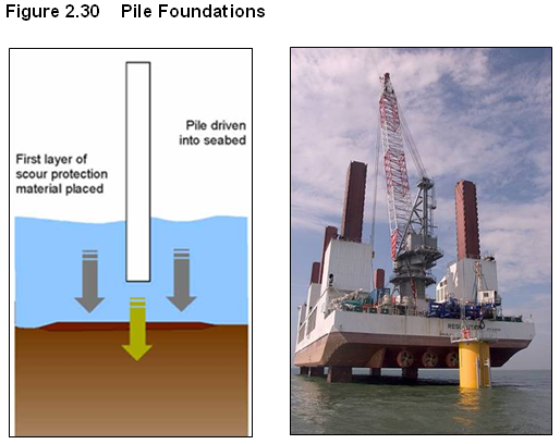
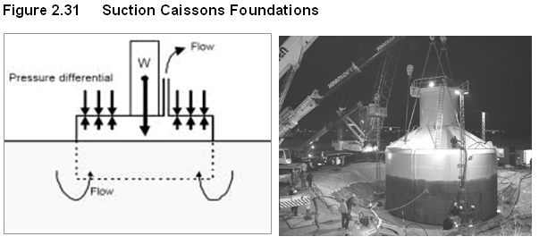
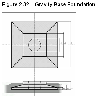
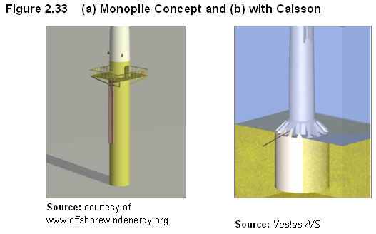
Table 2.5 Summary of Foundation & Substructure Options
Table 2.6 Anticipated Construction Vessel Types
Table 2.7 Number of Anticipated Vessel Movements from Port to Site
Table 2.8 Estimated Numbers of Operational Workboats
Table 3.1 ETWB 34/2002 Criteria for Dredged Sediment Classification
Table 3.2 Routine Marine Sediment Quality Monitoring Data (EPD, 2003 – 2006)
Table
3.3 Sediment Quality in
Table 3.4 Preliminary Estimated Volume of Sediment & Disposal Option (m3)
Table 3.5 Chemical Screening Results for Nearshore Stations S1 - S3
Table
4.1 Summary of WQOs for
Table 4.2 Water Supplies Department standards at Seawater Intakes
Table 4.3 Summary of Preferred Foundation and Substructure Options
Table 4.4 Worst-case Scenarios
Table 4.5 Summary Statistics of Marine Water Quality in Junk Bay WCZ between 2002 and 2006
Table 4.6 Summary Statistics of Marine Water Quality in Mirs Bay WCZ between 2002 and 2006
Table 4.7 Summary Statistics of Marine Water Quality in Port Shelter WCZ between 2002 and 2006
Table 4.8 Summary Statistics of Marine Water Quality in Eastern Buffer WCZ between 2002 and 2006
Table 4.9 Proposed Water Quality Assessment Criteria
Table 4.10 Proposed Assessment Criteria for Heavy Metals/Trace Organics
Table 4.11 Predicted Increases in SS (in mg/L) – Scenario 1 (Unmitigated Scenario)
Table 4.12 Predicted Increases in SS (mg/L) – Scenario 2 (Unmitigated Scenario)
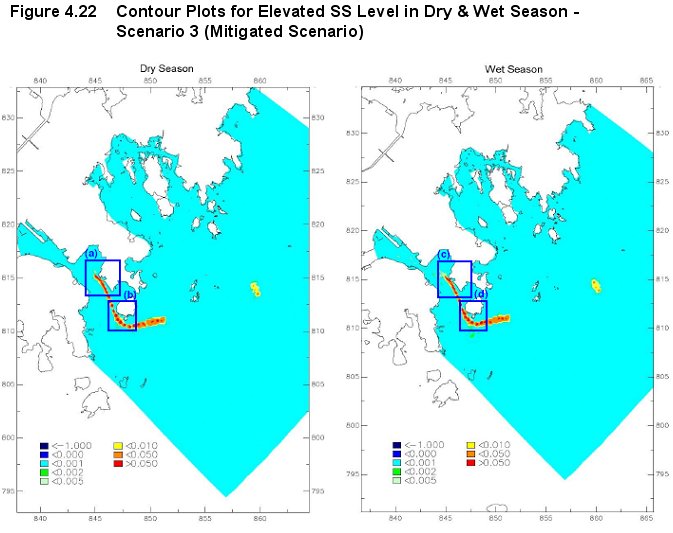
Table 4.13 Predicted Increases in SS (mg/L) – Scenario 3 (Unmitigated Scenario)
Table 4.14 Predicted Increases in SS (in mg/L) – Scenario 4 (Unmitigated Scenario)
Table 4.15 Predicted Increases in SS (in mg/L) – Scenario 5 (Unmitigated Scenario)
Table 4.16 Highest Arsenic Concentrations at Sediment Sampling Locations S1 to S7 and Required Dilution Rates
Table 4.17 Predicted Dilution Rates at Selected WSRs
Table 4.18 Calculated Arsenic Concentrations (mg/L) at Selected WSRs
Table 4.19 Predicted Sediment Deposition Rates (in g/m2/day) at Coral Communities in Dry Season – Scenarios 1 to 5 (Unmitigated Scenarios)
Table 4.20 Predicted Sediment Deposition Rates (in g/m2/day) at Coral Communities in Wet Season – Scenarios 1 to 5 (Unmitigated Scenarios)
Table 4.21 Predicted Depletion in DO due to Maximum Increase in SS Concentrations (in mg/L) – Dry Season (Unmitigated Scenarios)
Table 4.22 Predicted Depletion in DO due to Maximum Increase in SS Concentrations (in mg/L) – Wet Season (Unmitigated Scenarios)
Table 4.23 Resulting DO due to Maximum Increase in SS Concentrations (in mg/L) – Dry and Wet Season (Unmitigated Scenarios)
Table 4.24 Predicted Cumulative Impact Results (Unmitigated Scenario)
Table 4.25 Predicted Velocities at Monitoring Points (H1 to H7) in the Dry Season
Table 4.26 Predicted Velocities at Monitoring Points (H1 to H7) in the Wet Season
Table 4.27 Predicted Increases in SS (in mg/L) – Scenario 1 (Mitigated Scenario)
Table 4.28 Predicted Increases in SS (mg/L) – Scenario 2 (Mitigated Scenario)
Table 4.29 Predicted Increases in SS (mg/L) – Scenario 3 (Mitigated Scenario)
Table 4.30 Predicted Increases in SS (in mg/L) – Scenario 4
Table 4.31 Predicted Increases in SS (in mg/L) – Scenario 5
Table 4.32 Summary of Mitigation Measures for Scenarios 1 to 5
Table 4.33 Predicted Sediment Deposition Rates (in g/m2/day) at Coral Communities in Dry Season – Scenarios 1 to 5 (Mitigated Scenario)
Table 4.34 Predicted Sediment Deposition Rates (in g/m2/day) at Coral Communities in Wet Season – Scenarios 1 to 5 (Mitigated Scenario)
Table 4.35 Predicted Depletion in DO due to Maximum Increase in SS Concentrations (in mg/L) – Dry Season (Mitigated Scenarios)
Table 4.36 Predicted Depletion in DO due to Maximum Increase in SS Concentrations (in mg/L) – Wet Season (Mitigated Scenarios)
Table 5.1 Key Biodiversity Indicators for the Study Area from CityU 2002
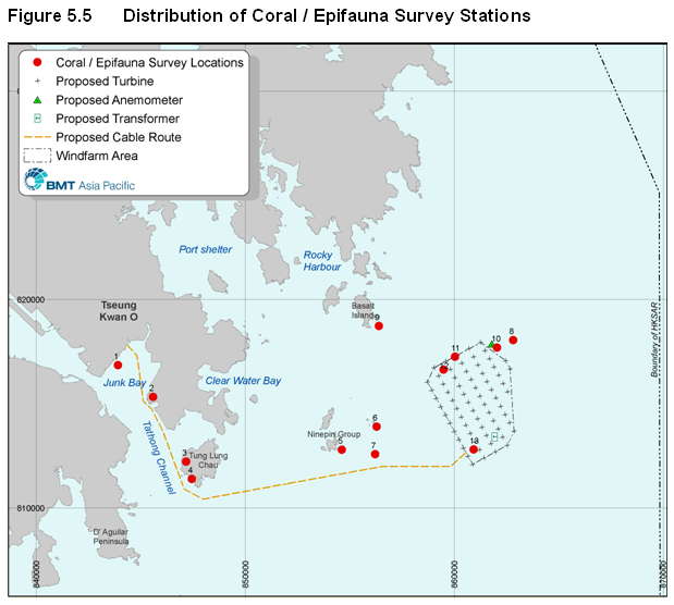
Table 5.2 Coral / Epifauna Survey Locations
Table 5.3 Characteristics of Benthic Infauna Sampling Stations
Table 5.4 Summary of species, individuals and biomass recorded at each station in wet and dry season surveys
Table 5.5 Univariate statistics for the infauna community (CityU, 2007)
Table
Table 5.6b Ecological Evaluation of Rocky Shore
Table
Table 5.6d Ecological Evaluation of Rocky Pinnacle
Table 5.7 Specific Habitat Evaluation of EIA Study Baseline Survey Locations
Table 5.8 Predicted Suspended Sediment concentrations (in mg/L) at representative Coral Sensitive Receivers: Unmitigated Scenario
Table 5.9 Predicted Sediment Deposition Rates (in g/m2/day) at Coral Communities in Dry Season – Unmitigated Scenarios 1 to 5
Table 5.10 Predicted Sediment Deposition Rates (in g/m2/day) at Coral Communities in Wet Season – Unmitigated Scenarios 1 to 5
Table 5.11 Predicted Suspended Sediment concentrations (in mg/L) at representative Coral Sensitive Receivers: Mitigated Scenario
Table 5.12 Predicted Sediment Deposition Rates (in g/m2/day) at Coral Communities in Dry Season – Mitigated Scenarios 1 to 5
Table 5.13 Predicted Sediment Deposition Rates (in g/m2/day) at Coral Communities in Wet Season – Mitigated Scenarios 1 to 5
Table 6.1 Confirmed Non-Resident Cetacean Sighting Records
Table 6.2 Summary of Marine Mammal Observations
Table 6.3 Reef-Associated Fish Species around the Ninepins
Table 6.4 Shark, Ray & Skates in HKSAR Waters
Table 6.5 Predicted Suspended Sediment concentrations (in mg/L) at representative pelagic receivers: Unmitigated Scenario
Table 7.1 Summary of Boat-based Survey, Aerial Surveys and Radar Surveys with Regard to Advantages and Limitations
Table 7.2 Configuration of the Proposed Turbine Options
Table 7.3 Determination of Ornithological Significance
Table 7.4 Determination of Magnitude of Effects on Birds
Table 7.5 Matrix of Magnitude and Sensitivity for Determination of Impact Significance
Table
7.6 Migratory and Visitor Seabird
Species in
Table 7.7 Summary of Numbers of Seabirds Recorded in HKBWS Seabird Survey in Spring 2006 (HKWBS, 2006)
Table 7.8 Minimum Number of Adults and Fledged Juveniles of Black-naped Tern Sterna sumatrana, Bridled Tern Sterna anaethetus, and Roseate Tern Sterna dougallii recorded between 1993 – 1997 at the East Ninepin by HKBWS (Carey et al, 2001
Table 7.9 Available Results of On-going Breeding Tern Surveys in SE Waters of Hong Kong Conducted by HKBWS (Extracted from HKBWS's website)
Table 7.10 Summary of the Results of WBSE Breeding Site Survey in SE Waters Between 2002/03 and 2006/07 (AFCD unpublished data)
Table 7.11 Dates of Boat-based Surveys Undertaken in the Study Area Between May 2006 and December 2007.
Table
7.12 Total Counts of Bird Species
Recorded during Boat-based Surveys within the Study Area (the proposed wind
farm area (WF) with
Table
7.13 Total Counts of Bird Species
Recorded during Boat-based Surveys within the Study Area (the proposed wind
farm area (WF) with
Table
7.14 The Peak Daily Counts of Bird
Species Recorded during Boat-based Surveys within the Study Area (the proposed
wind farm (WF) with
Table
7.15 The Peak Daily Counts of Bird
Species Recorded during Boat-based Surveys within the Study Area (the proposed
wind farm (WF) with
Table 7.16 Flight Height Categories for Scenario A and Scenario B
Table 7.17 Number of Birds Observed at Each Flight Height Category within the Survey Area between May 2006 and December 2007 for Scenario A
Table 7.18 Number of Birds Observed at Each Flight Height Category within the Survey Area between May 2006 and December 2007 for Scenario B
Table 7.19 Number of Birds Observed Under Each Behavioural Category with the Study Area between May 2006 and May 2007
Table 7.20 Summary of Residential Status and Conservation Status of Bird Species Recorded in the Survey Area
Table 7.21 Species of Local and /or Regional Conservation Concern and Their Abundance and Distribution in the Study Area (Data between May 2006 and December 2007)
Table 7.22 Collision Rates of Black-naped Tern in Both the Worst Case and the Typical Condition for Scenario A
Table 7.23 Collision Rates of Black-naped Tern in Both the Worst Case and the Typical Condition for Scenario B
Table 7.24 Collision Rates of Bridled Tern in Both the Worst Case and the Typical Condition for Scenario A
Table 7.25 Collision Rates of Bridled Tern in Both the Worst Case and the Typical Condition for Scenario B
Table 7.26 Collision Rates of Red-necked Phalarope in Both the Worst Case and the Typical Condition for Scenario A
Table 7.27 Collision Rates of Red-necked Phalarope in Both the Worst Case and the Typical Condition for Scenario B
Table 7.28 Collision Rates of Cattle Egret in Both the Worst Case and Typical Conditions for Scenario A
Table 7.29 Collision Rates of Cattle Egret in Both the Worst Case and Typical Conditions for Scenario B
Table 7.30 Collision Rates of Aleutian Tern in Both the Worst Case and Typical Conditions for Scenario A
Table 7.31 Collision Rates of Aleutian Tern in Both the Worst Case and Typical Conditions for Scenario B
Table 7.32 Collision Rates of White-winged Black Tern in Both the Worst Case and Typical Conditions for Scenario A
Table 7.33 Collision Rates of White-winged Black Tern in Both the Worst Case and Typical Conditions for Scenario B
Table 7.34 Collision Rates of Black-tailed Gull in Both the Worst Case and Typical Conditions for Scenario A
Table 7.35 Collision Rates of Black-tailed Gull in Both the Worst Case and Typical Conditions for Scenario B
Table 8.1 Typical Trawling Speed
Table 8.2 Typical Vessel Sizes
Table 8.3 Top 10 Most Commonly Caught Species
Table 8.4 Fishing Activity Ranking
Table 8.5 Fishing Activity in the Selected Fishing Areas
Table 8.6 Fisheries Productivity Ranking
Table 8.7 Fish Productivity across the Study Area
Table 8.8 Productivity of Top HKSAR Species in the Study Area
Table 8.9 Summary of Fish Culture Zones in the Study Area
Table 8.10 Indicative species value ranking system
Table 8.11 Value of common catch from Shau Kei Wan
Table 8.12 Predicted suspended sediment concentrations (in mg/L) at representative fisheries receivers: Unmitigated Scenario
Table 8.13 Mixing zone radii for marine construction activities
Table 9.1 Description of Selected Boreholes
Table 9.2 Matrix of Impact Significance
Table 9.3 Targets with Archaeological Potential in the Wind Farm Area
Table
9.4 Targets with Archaeological
Potential along the
Table 9.5 Distance Separation of Targets from Works Areas
Table 10.1 Relationship between Receptor Sensitivity and Impact Magnitude in Defining Impact Significance
Table 10.2 Proposed (Pre) Construction Phase Landscape and Visual Mitigation Measures
Table 10.3 Proposed Operational Phase Landscape and Visual Mitigation Measures
Table 10.4 Significance of Landscape Impacts in (Pre) Construction and Operational Phases (Negative Impacts unless otherwise stated)
Table 10.5 Significance of Visual Impacts in the (Pre) Construction and Operational Phases (Note: All impacts negative unless otherwise noted)
Table 12.1 Incorporation of Stakeholder Feedback into EIA
List of Figures
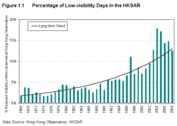
Figure 1.1 Percentage of Low-visibility Days in the HKSAR
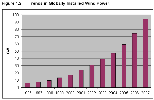
Figure 1.2 Trends in Globally Installed Wind Power
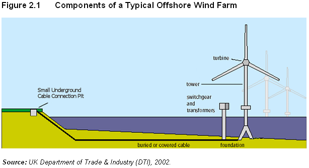
Figure 2.1 Components of a Typical Offshore Wind Farm
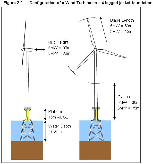
Figure 2.2 Configuration of a Wind Turbine on a 4 legged jacket foundation
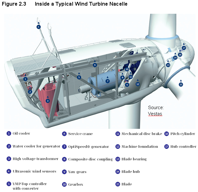
Figure 2.3 Inside a Typical Wind Turbine Nacelle
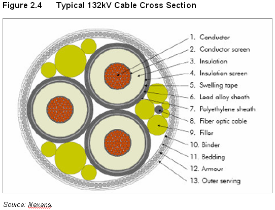
Figure 2.4 Typical 132kV Cable Cross Section
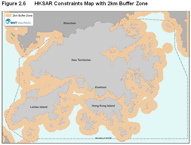
Figure 2.6 HKSAR Constraints Map with 2km Buffer Zone
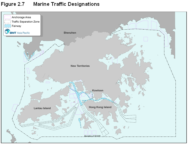
Figure 2.7 Marine Traffic Designations
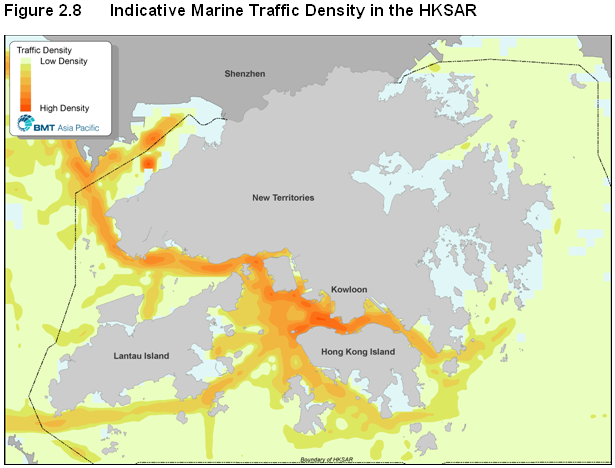
Figure 2.8 Indicative Marine Traffic Density in the HKSAR
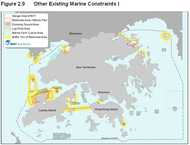
Figure 2.9 Other Existing Marine Constraints I
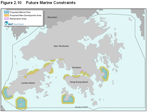
Figure 2.10 Future Marine Constraints
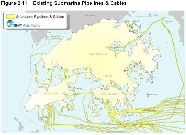
Figure 2.11 Existing Submarine Pipelines & Cables
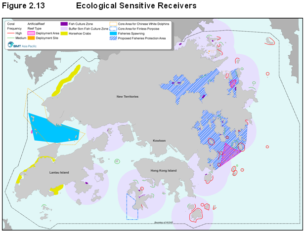
Figure 2.13 Ecological Sensitive Receivers
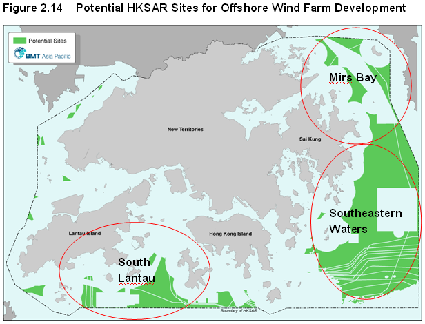
Figure 2.14 Potential HKSAR Sites for Offshore Wind Farm Development
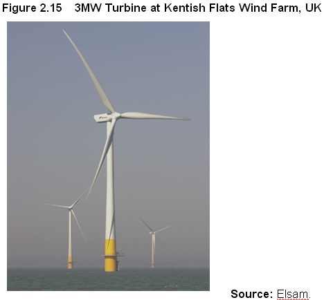
Figure 2.15 3MW Turbine at Kentish Flats Wind Farm, UK
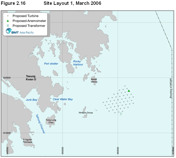
Figure 2.16 Site Layout 1, March 2006
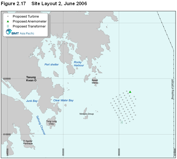
Figure 2.17 Site Layout 2, June 2006
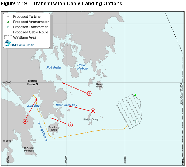
Figure 2.19 Transmission Cable Landing Options
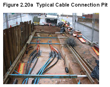
Figure 2.20a Typical Cable Connection Pit
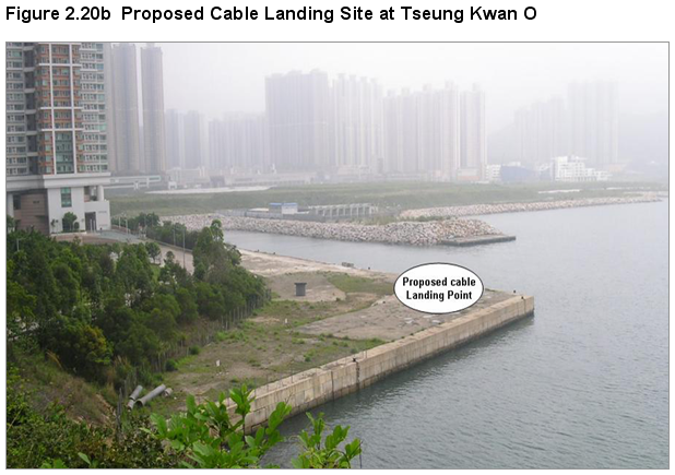
Figure 2.20b Proposed Cable Landing Site at Tseung Kwan O
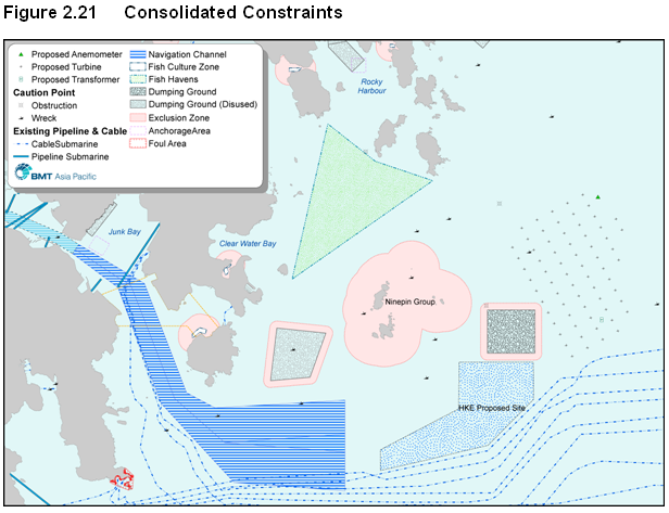
Figure 2.21 Consolidated Constraints
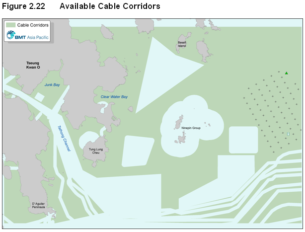
Figure 2.22 Available Cable Corridors
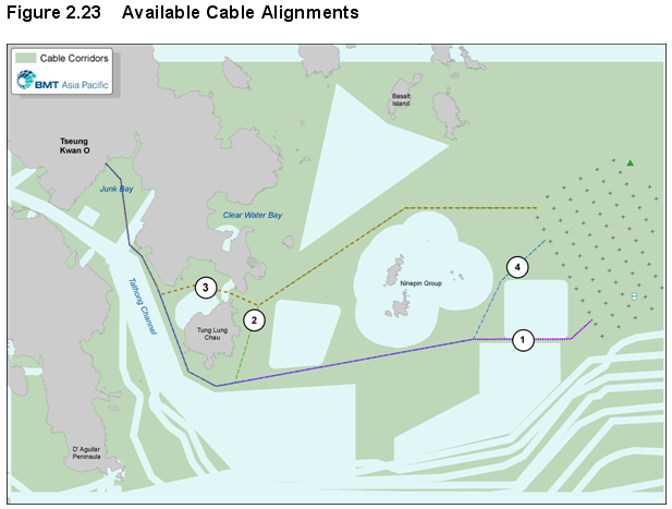
Figure 2.23 Available Cable Alignments
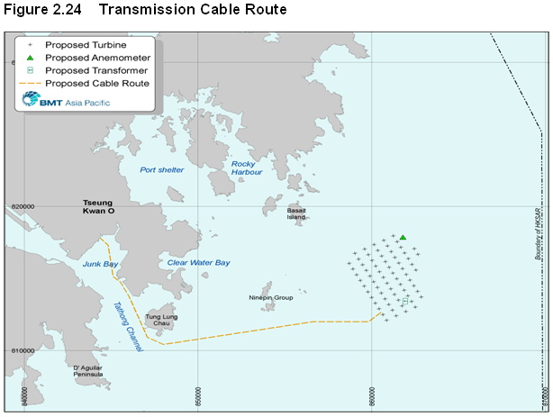
Figure 2.24 Transmission Cable Route
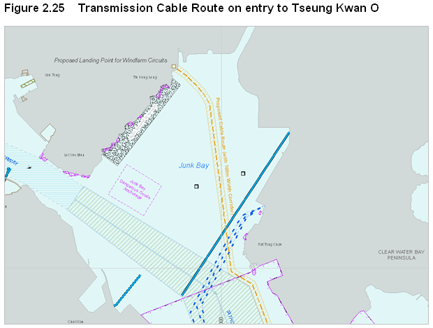
Figure 2.25 Transmission Cable Route on entry to Tseung Kwan O
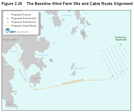
Figure 2.26 The Baseline Wind Farm Site and Cable Route Alignment
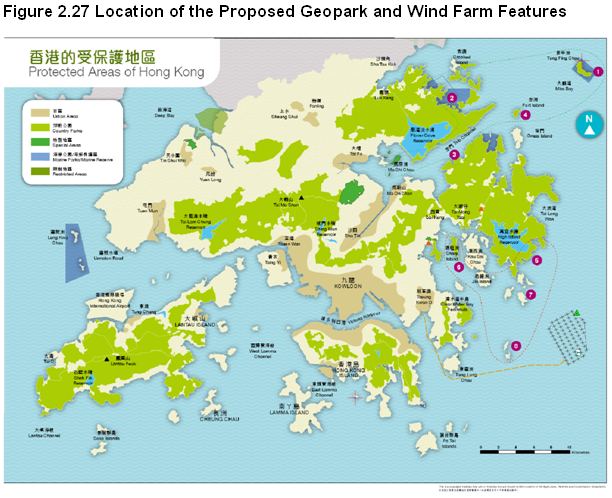
Figure 2.27 Location of the Proposed Geopark and Wind Farm Features
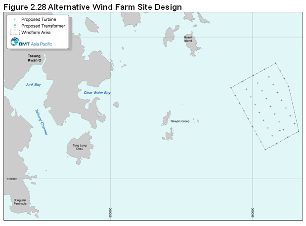
Figure 2.28 Alternative Wind Farm Site Design
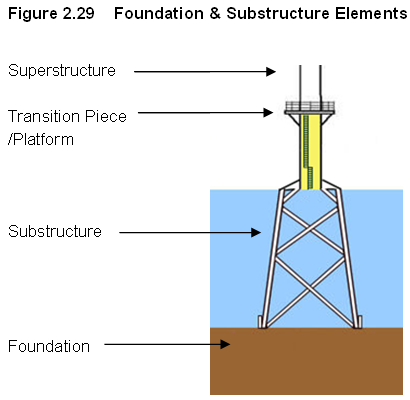
Figure 2.29 Foundation & Substructure Elements
Figure 2.31 Suction Caissons Foundations
Figure 2.32 Gravity Base Foundation
Figure 2.33 (a) Monopile Concept and (b) with Caisson
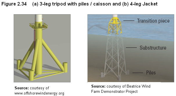
Figure 2.34 (a) 3-leg tripod with piles / caisson and (b) 4-leg Jacket
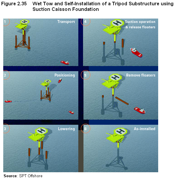
Figure 2.35 Wet Tow and Self-Installation of a Tripod Substructure using Suction Caisson Foundation
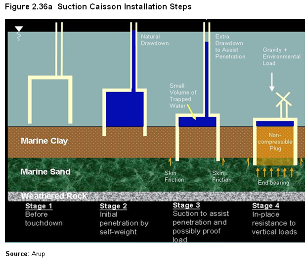
Figure 2.36a Suction Caisson Installation Steps
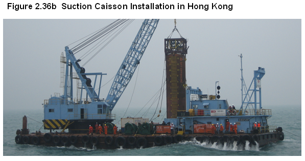
Figure 2.36b Suction Caisson Installation in Hong Kong
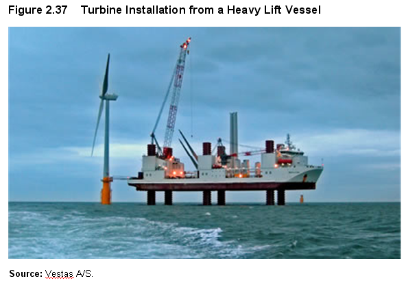
Figure 2.37 Turbine Installation from a Heavy Lift Vessel
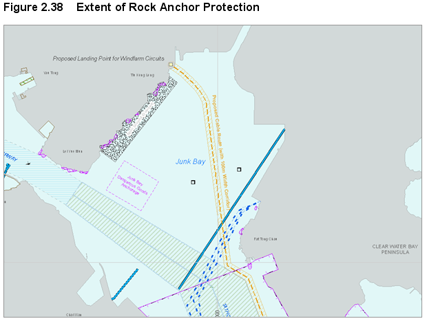
Figure 2.38 Extent of Rock Anchor Protection
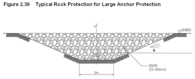
Figure 2.39 Typical Rock Protection for Large Anchor Protection
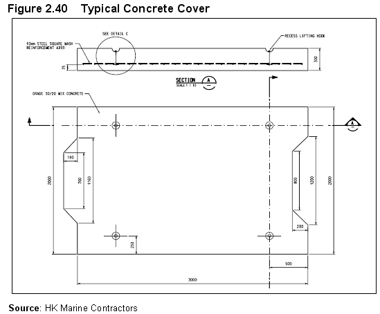
Figure 2.40 Typical Concrete Cover
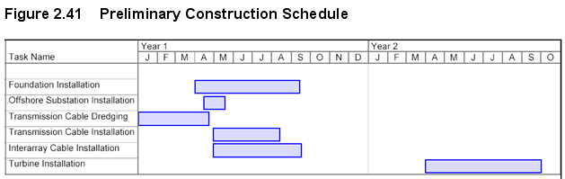
Figure 2.41 Preliminary Construction Schedule
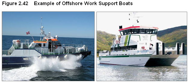
Figure 2.42 Example of Offshore Work Support Boats
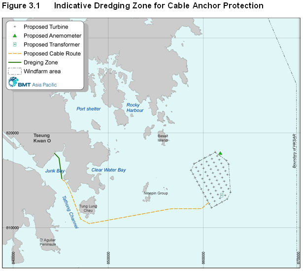
Figure 3.1 Indicative Dredging Zone for Cable Anchor Protection
Figure 3.2 Schematic of Rock Armour Protection
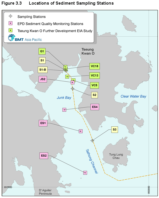
Figure 3.3 Locations of Sediment Sampling Stations
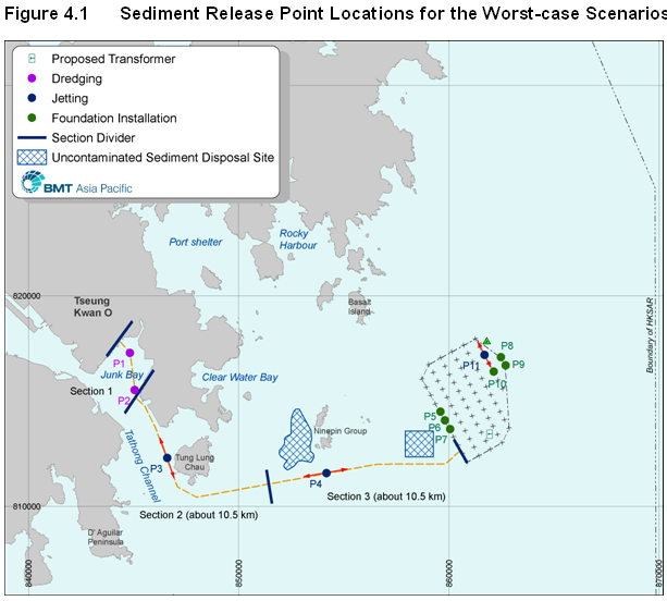
Figure 4.1 Sediment Release Point Locations for the Worst-case Scenarios
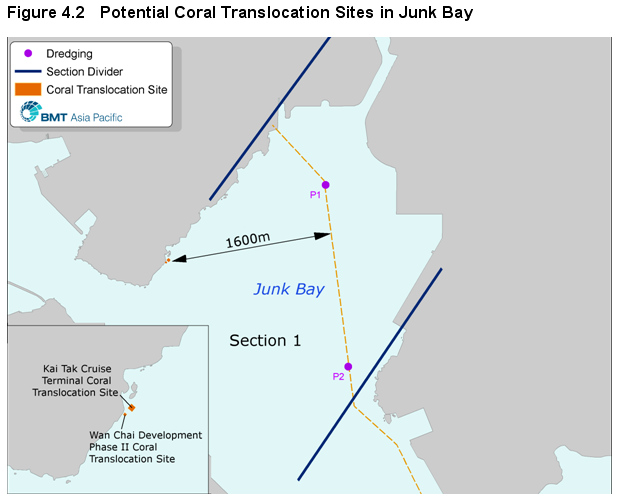
Figure 4.2 Potential Coral Translocation Sites in Junk Bay
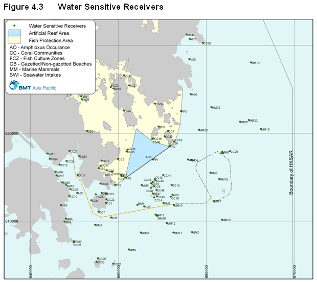
Figure 4.3 Water Sensitive Receivers
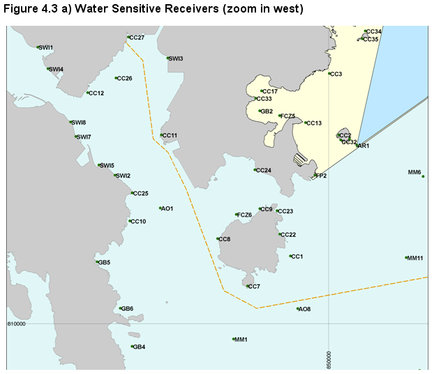
Figure 4.3a Water Sensitive Receivers (zoom in west)
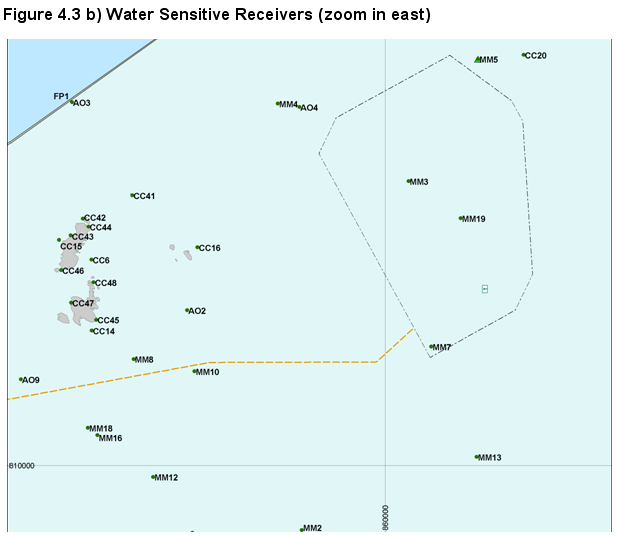
Figure 4.3b Water Sensitive Receivers (zoom in east)
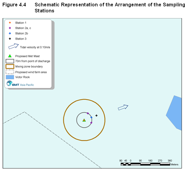
Figure 4.4 Schematic Representation of the Arrangement of the Sampling Stations
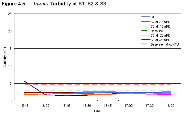
Figure 4.5 In-situ Turbidity at S1, S2 & S3
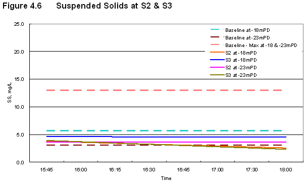
Figure 4.6 Suspended Solids at S2 & S3
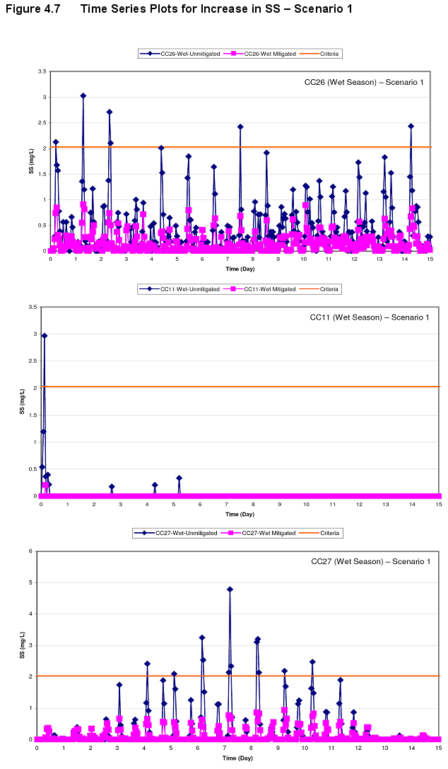
Figure 4.7 Time Series Plots for Increase in SS – Scenario 1
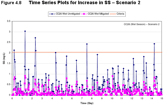
Figure 4.8 Time Series Plots for Increase in SS – Scenario 2
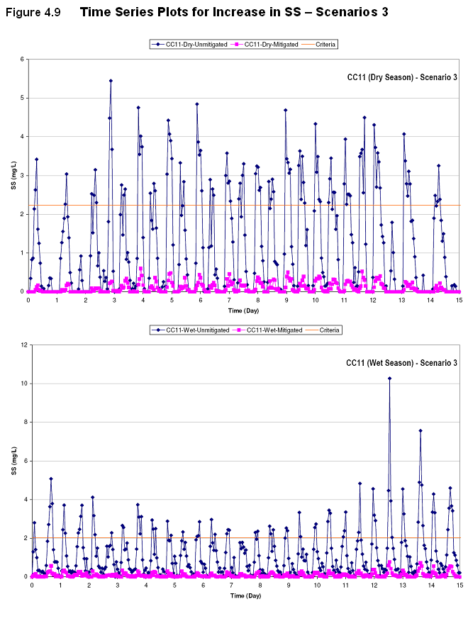
Figure 4.9 Time Series Plots for Increase in SS – Scenarios 3
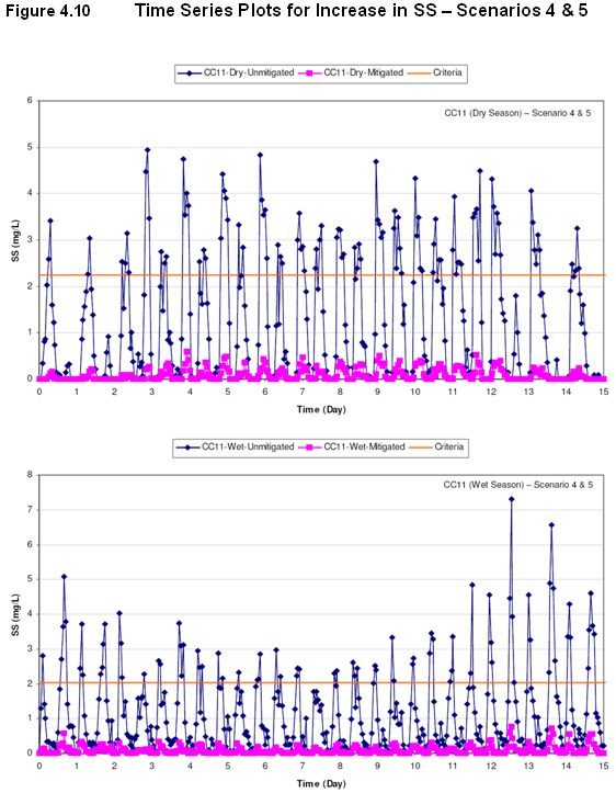
Figure 4.10 Time Series Plots for Increase in SS – Scenarios 4 & 5
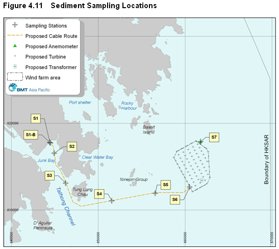
Figure 4.11 Sediment Sampling Locations
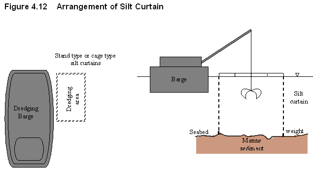
Figure 4.12 Arrangement of Silt Curtain
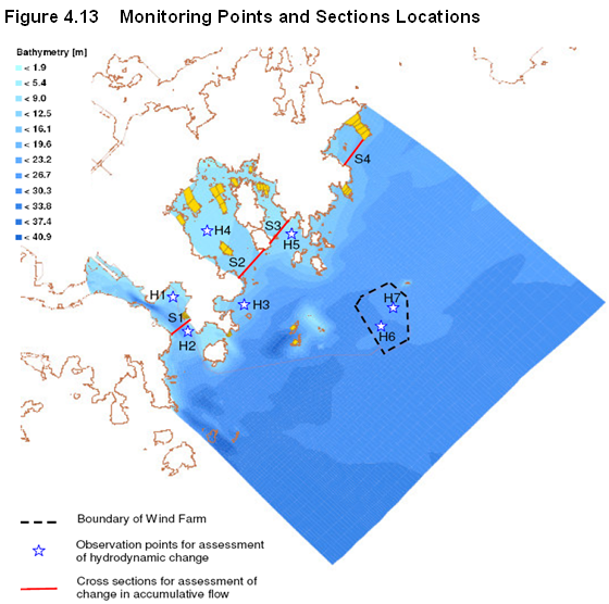
Figure 4.13 Monitoring Points and Sections Locations
Figure 4.14a Accumulated Flows at S1 – Dry Season
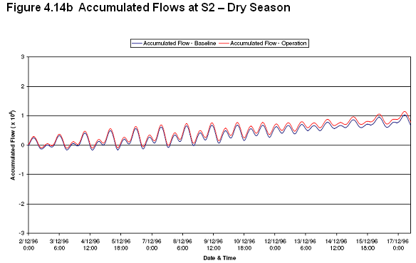
Figure 4.14b Accumulated Flows at S2 – Dry Season
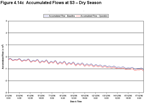
Figure 4.14c Accumulated Flows at S3 – Dry Season
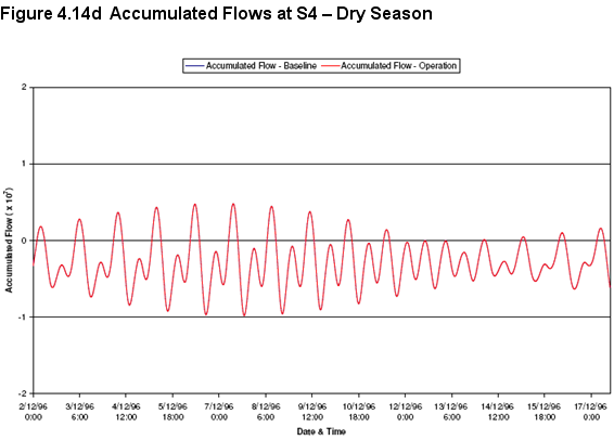
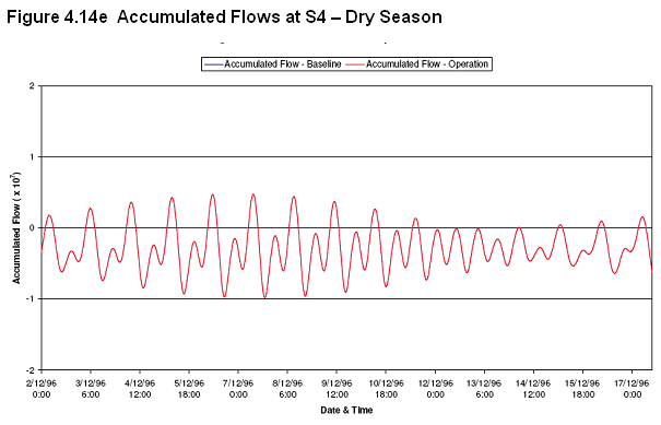
Figure 4.14d Accumulated Flows at S4 – Dry Season
Figure 4.14e Accumulated Flows at S5 – Dry Season
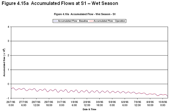
Figure 4.15a Accumulated Flows at S1 – Wet Season
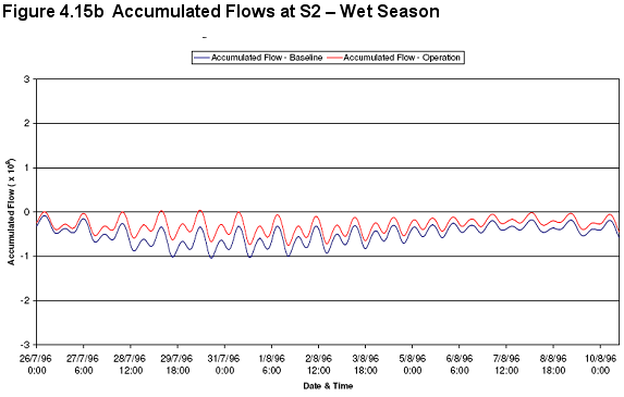
Figure 4.15b Accumulated Flows at S2 – Wet Season
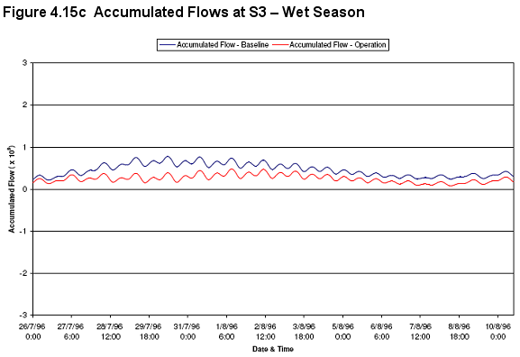
Figure 4.15c Accumulated Flows at S3 – Wet Season
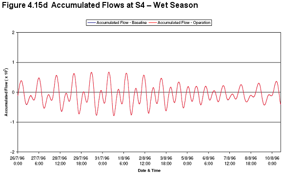
Figure 4.15d Accumulated Flows at S4 – Wet Season
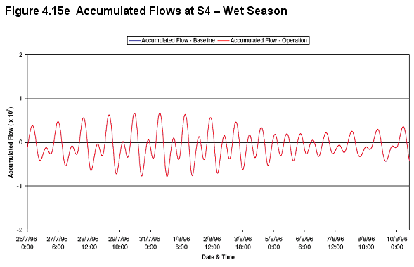
Figure 4.15e Accumulated Flows at S45– Wet Season
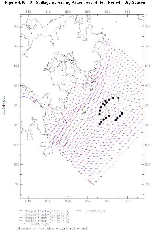
Figure 4.16 Oil Spillage Spreading Pattern over 4-Hour Period – Dry Season
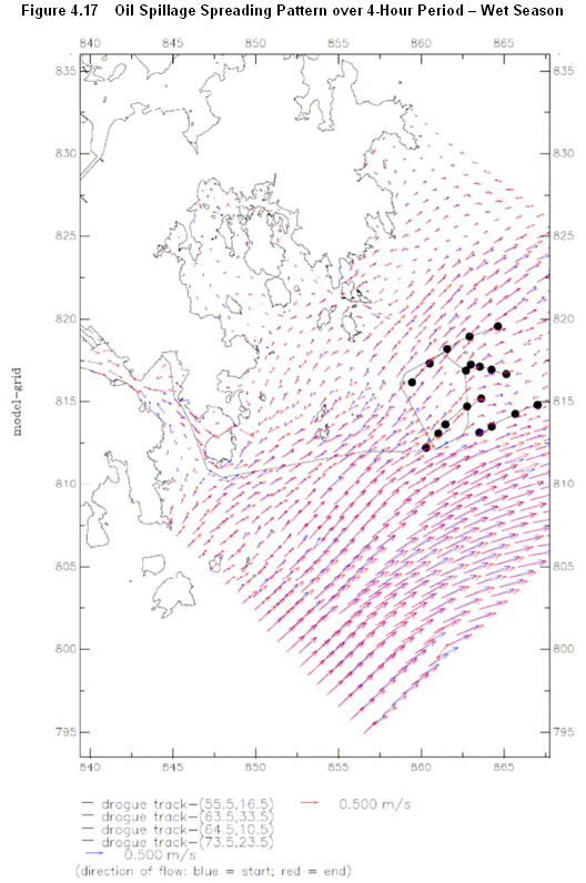
Figure 4.17 Oil Spillage Spreading Pattern over 4-Hour Period – Wet Season
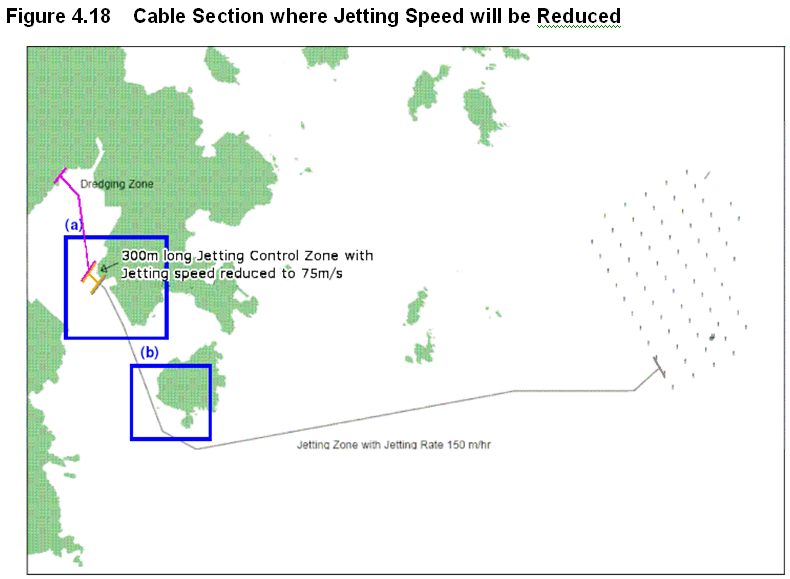
Figure 4.18 Cable Section where Jetting Speed will be Reduced
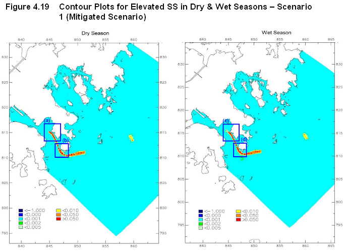
Figure 4.19 Contour Plots for Elevated SS in Dry & Wet Seasons – Scenario 1 (Mitigated Scenario)
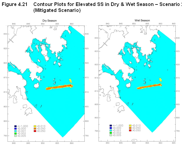
Figure 4.21 Contour Plots for Elevated SS in Dry & Wet Season – Scenario 2 (Mitigated Scenario)
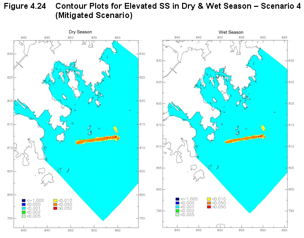
Figure 4.24 Contour Plots for Elevated SS in Dry & Wet Season – Scenario 4 (Mitigated Scenario)
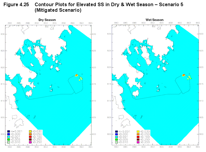
Figure 4.25 Contour Plots for Elevated SS in Dry & Wet Season – Scenario 5 (Mitigated Scenario)
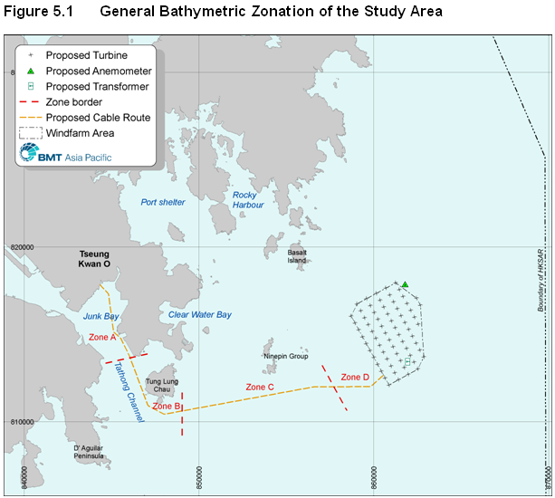
Figure 5.1 General Bathymetric Zonation of the Study Area
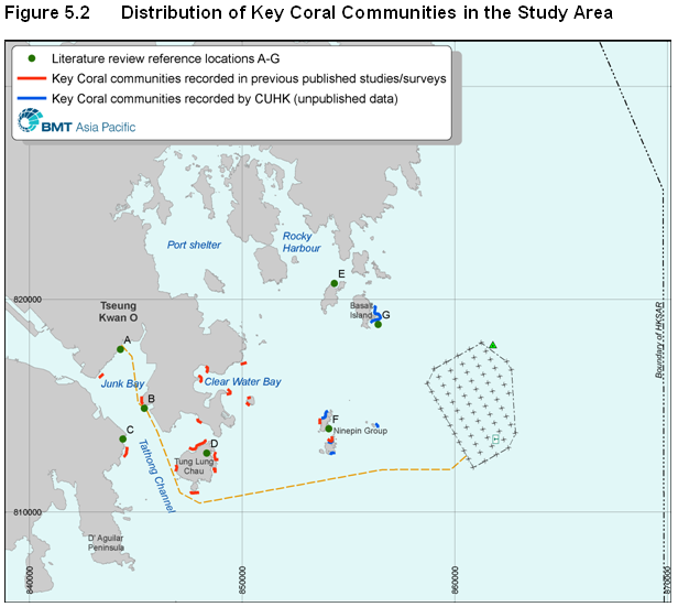
Figure 5.2 Distribution of Key Coral Communities in the Study Area
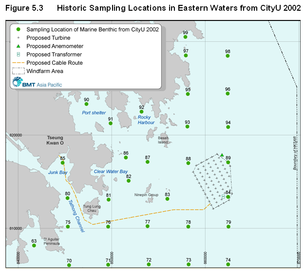
Figure 5.3 Historic Sampling Locations in Eastern Waters from CityU 2002
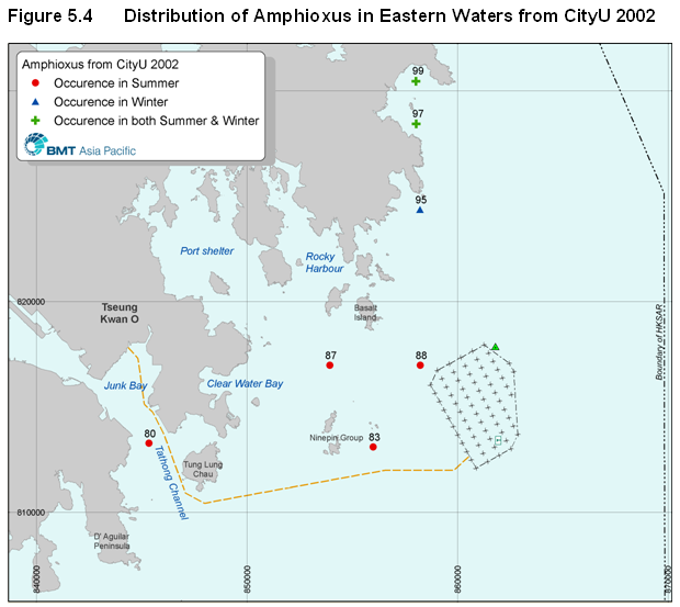
Figure 5.4 Distribution of Amphioxus in Eastern Waters from CityU 2002
Figure 5.5 Distribution of Coral / Epifauna Survey Stations
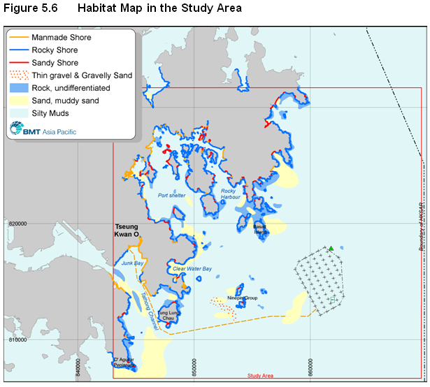
Figure 5.6 Habitat Map in the Study Area
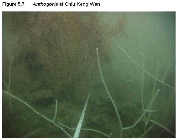
Figure 5.7 Anthogoria at Chiu Keng Wan
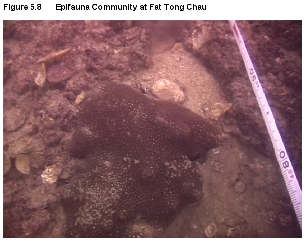
Figure 5.8 Epifauna Community at Fat Tong Chau
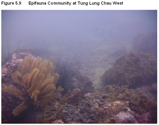
Figure 5.9 Epifauna Community at Tung Lung Chau West
Figure 5.10 Paraminabea Lobate Orange SP1 at South Ninepins
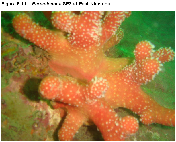
Figure 5.11 Paraminabea SP3 at East Ninepins
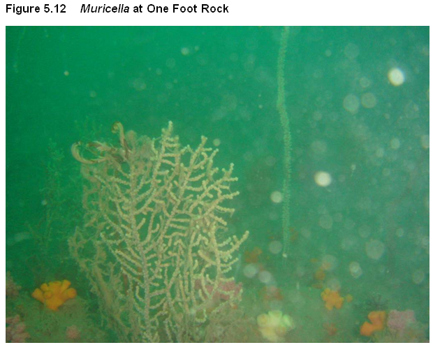
Figure 5.12 Muricella at One Foot Rock
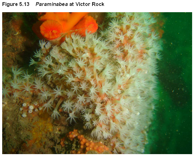
Figure 5.13 Paraminabea at Victor Rock
Figure 5.14 Scleronephthya at Basalt Island
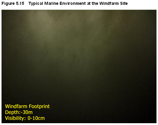
Figure 5.15 Typical Marine Environment at the Windfarm Site
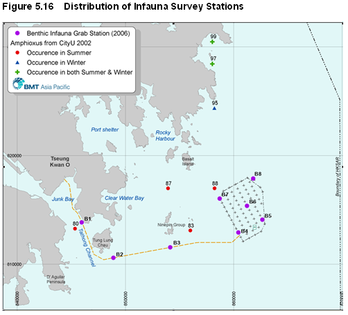
Figure 5.16 Distribution of Infauna Survey Stations
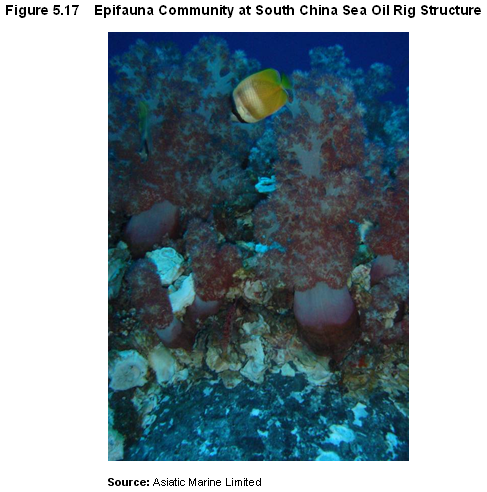
Figure 5.17 Epifauna Community at South China Sea Oil Rig Structure
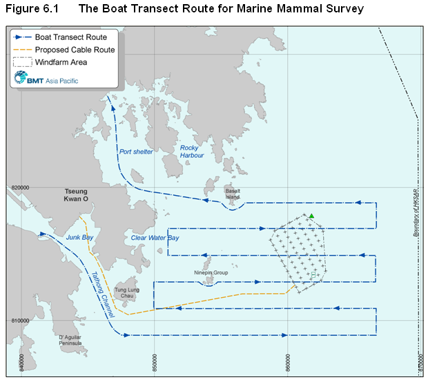
Figure 6.1 The Boat Transect Route for Marine Mammal Survey
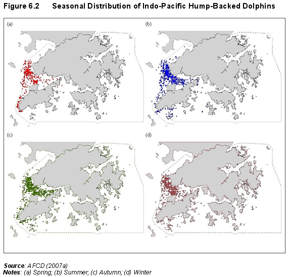
Figure 6.2 Seasonal Distribution of Indo-Pacific Hump-Backed Dolphins
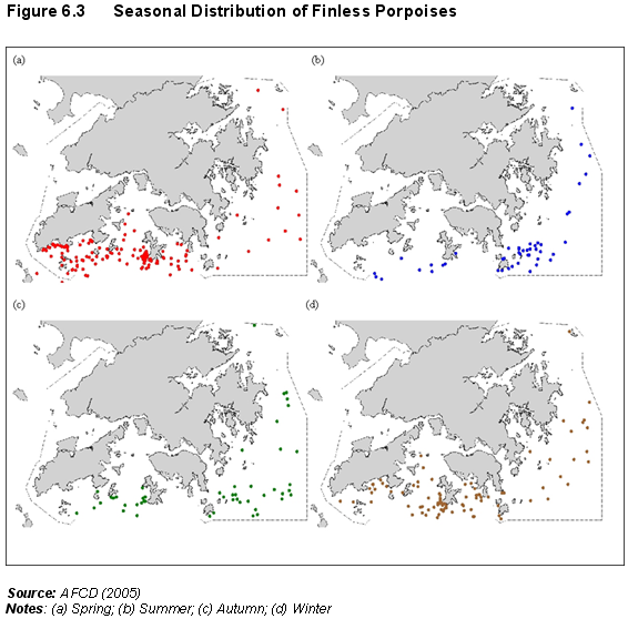
Figure 6.3 Seasonal Distribution of Finless Porpoises
Figure 6.4 AFCD Marine Mammal Survey Transect Routes
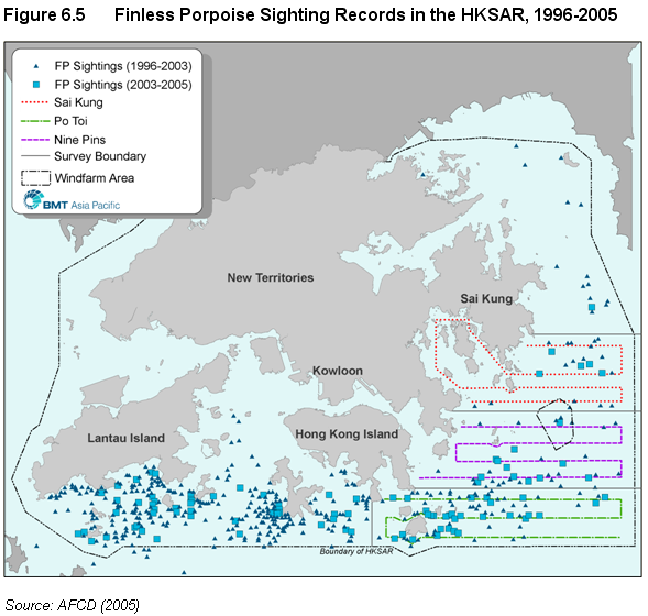
Figure 6.5 Finless Porpoise Sighting Records in the HKSAR, 1996-2005
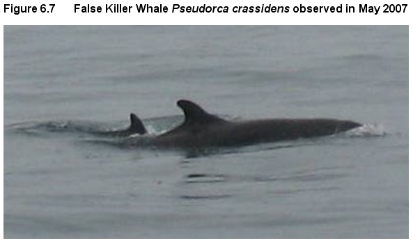
Figure 6.7 False Killer Whale Pseudorca crassidens observed in May 2007
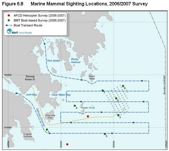
Figure 6.8 Marine Mammal Sighting Locations, 2006/2007 Survey
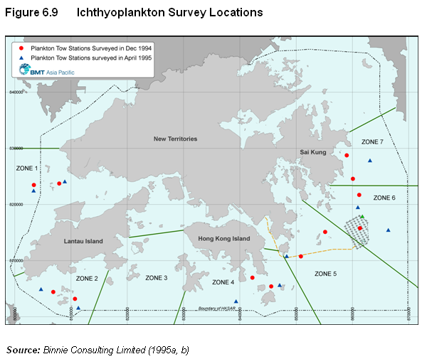
Figure 6.9 Ichthyoplankton Survey Locations
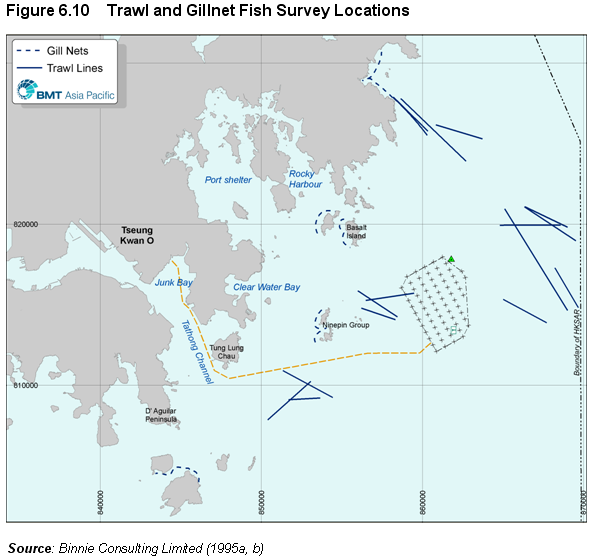
Figure 6.10 Trawl and Gillnet Fish Survey Locations
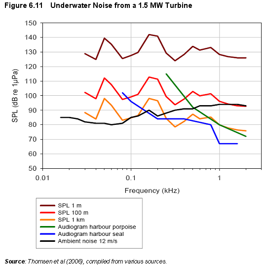
Figure 6.11 Underwater Noise from a 1.5 MW Turbine
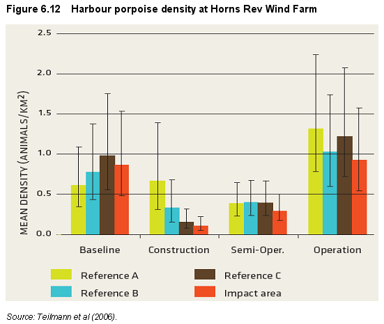
Figure 6.12 Harbour porpoise density at Horns Rev Wind Farm
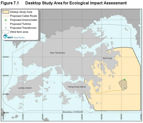
Figure 7.1 Desktop Study Area for Ecological Impact Assessment
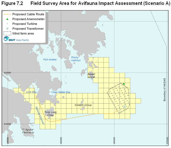
Figure 7.2 Field Survey Area for Avifauna Impact Assessment (Scenario A)
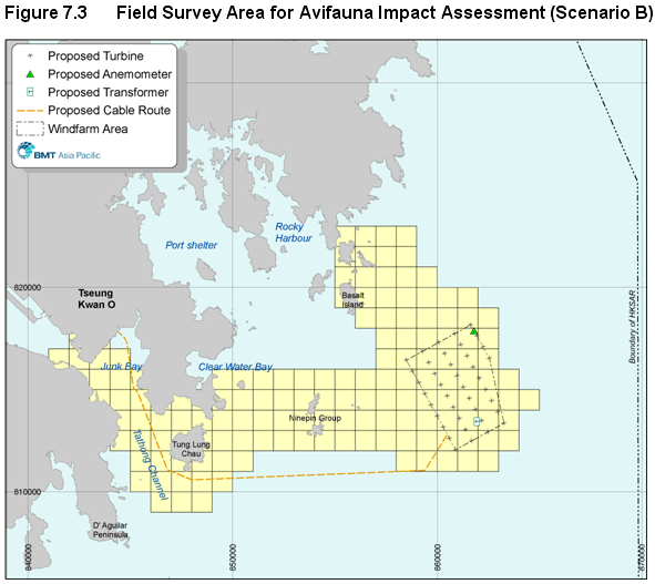
Figure 7.3 Field Survey Area for Avifauna Impact Assessment (Scenario B)
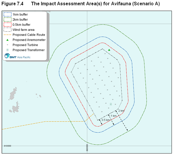
Figure 7.4 The Impact Assessment Area(s) for Avifauna (Scenario A)
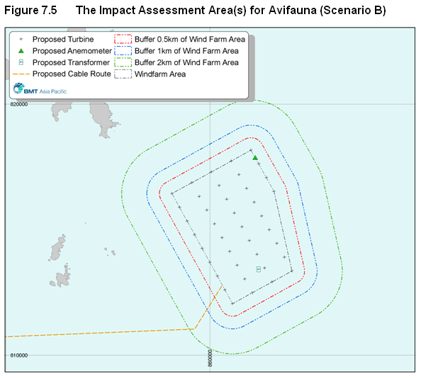
Figure 7.5 The Impact Assessment Area(s) for Avifauna (Scenario B)
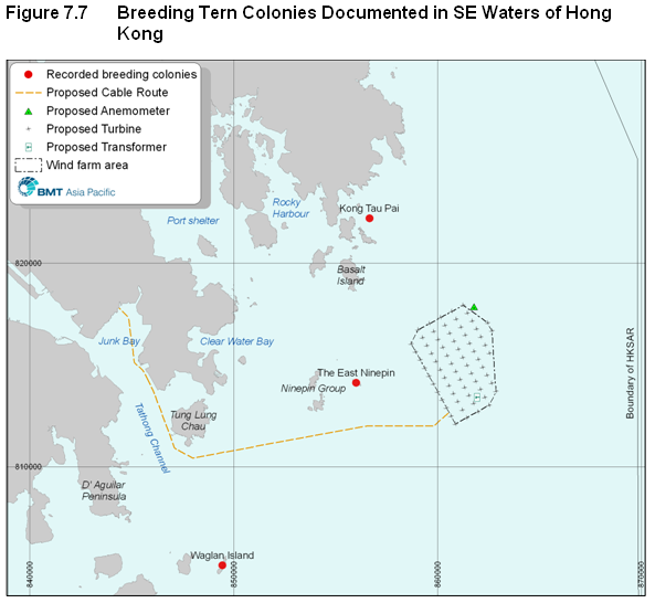
Figure 7.7 Breeding Tern Colonies Documented in SE Waters of Hong Kong
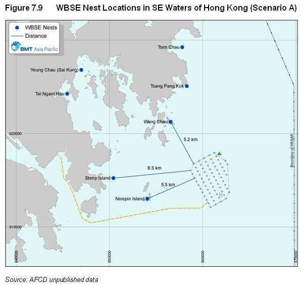
Figure 7.9 WBSE Nest Locations in SE Waters of Hong Kong (Scenario A)
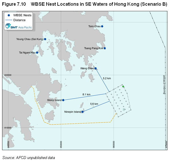
Figure 7.10 WBSE Nest Locations in SE Waters of Hong Kong (Scenario B)
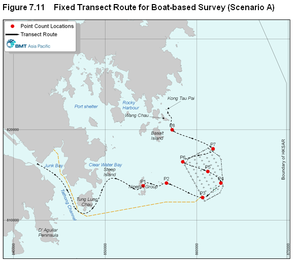
Figure 7.11 Fixed Transect Route for Boat-based Survey (Scenario A)
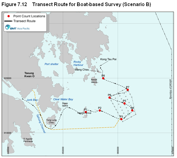
Figure 7.12 Transect Route for Boat-based Survey (Scenario B)
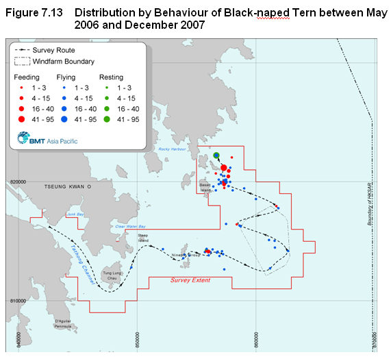
Figure 7.13 Distribution by Behaviour of Black-naped Tern between May 2006 and December 2007
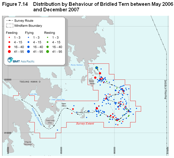
Figure 7.14 Distribution by Behaviour of Bridled Tern between May 2006 and December 2007
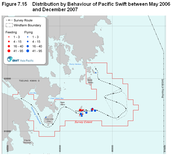
Figure 7.15 Distribution by Behaviour of Pacific Swift between May 2006 and December 2007
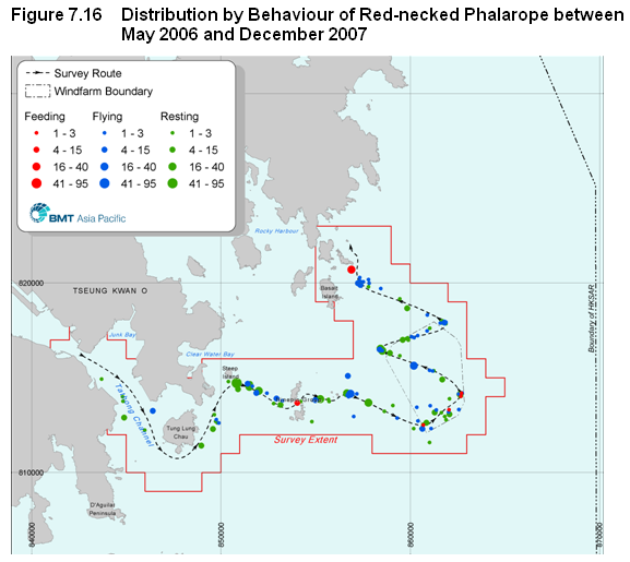
Figure 7.16 Distribution by Behaviour of Red-necked Phalarope between May 2006 and December 2007
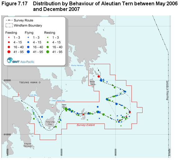
Figure 7.17 Distribution by Behaviour of Aleutian Tern between May 2006 and December 2007
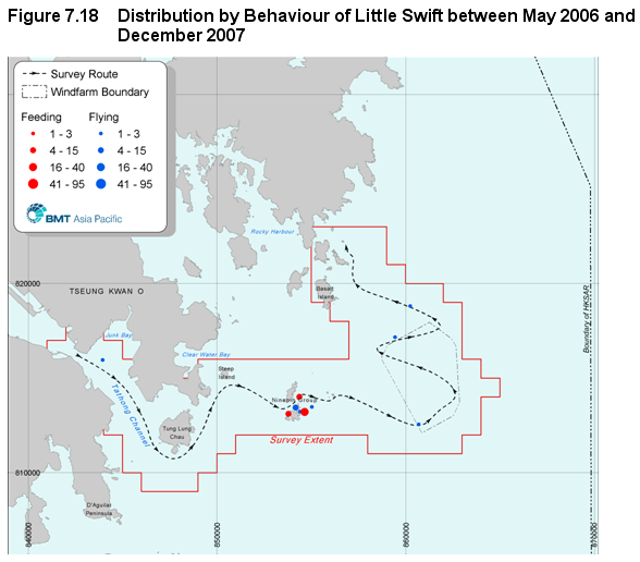
Figure 7.18 Distribution by Behaviour of Little Swift between May 2006 and December 2007
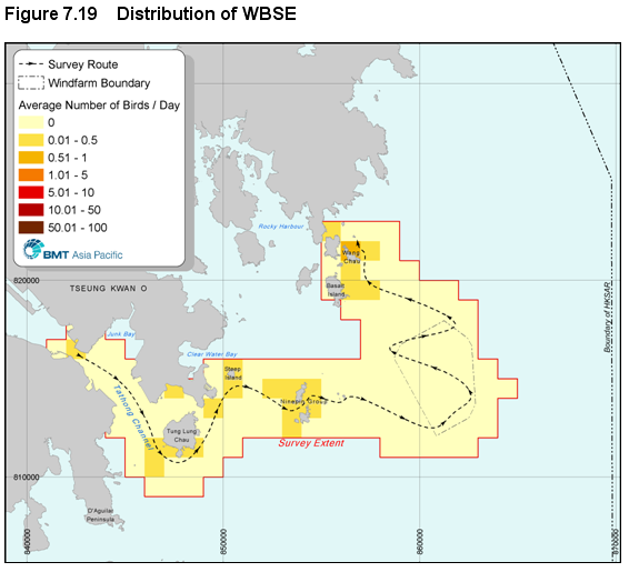
Figure 7.19 Distribution of WBSE
Figure 7.20 Distribution of Black-naped Tern
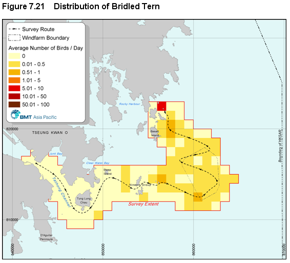
Figure 7.21 Distribution of Bridled Tern
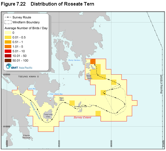
Figure 7.22 Distribution of Roseate Tern
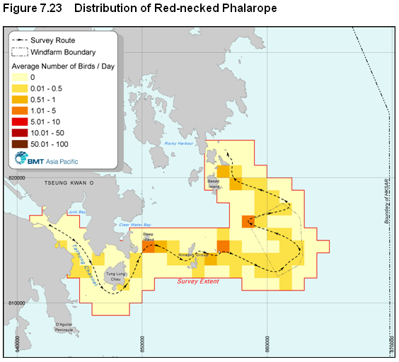
Figure 7.23 Distribution of Red-necked Phalarope
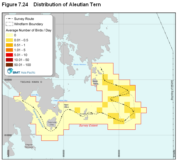
Figure 7.24 Distribution of Aleutian Tern
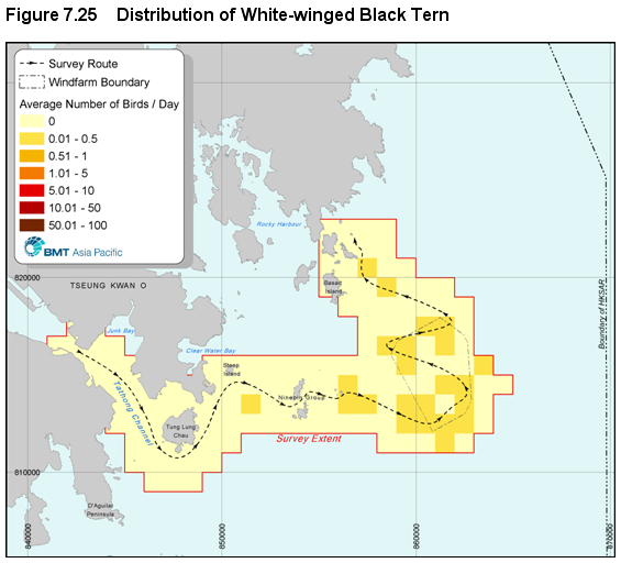
Figure 7.25 Distribution of White-winged Black Tern
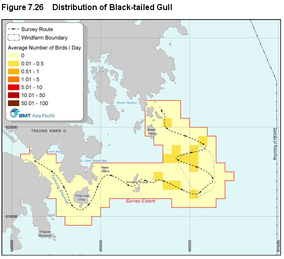
Figure 7.26 Distribution of Black-tailed Gull
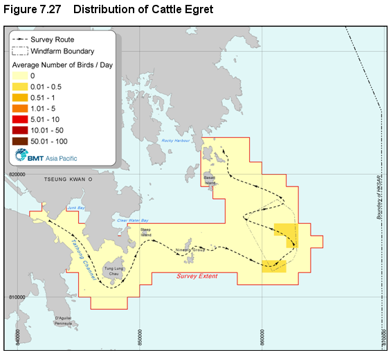
Figure 7.27 Distribution of Cattle Egret
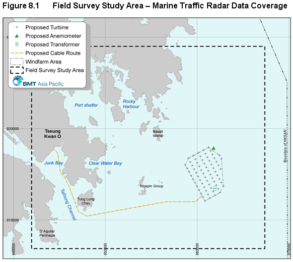
Figure 8.1 Field Survey Study Area – Marine Traffic Radar Data Coverage
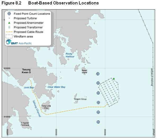
Figure 8.2 Boat-Based Observation Locations
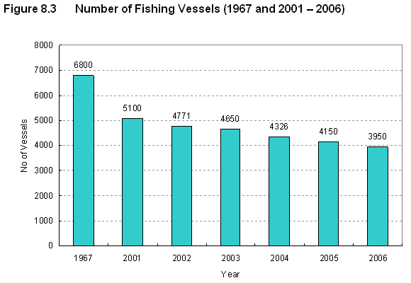
Figure 8.3 Number of Fishing Vessels (1967 and 2001 – 2006)
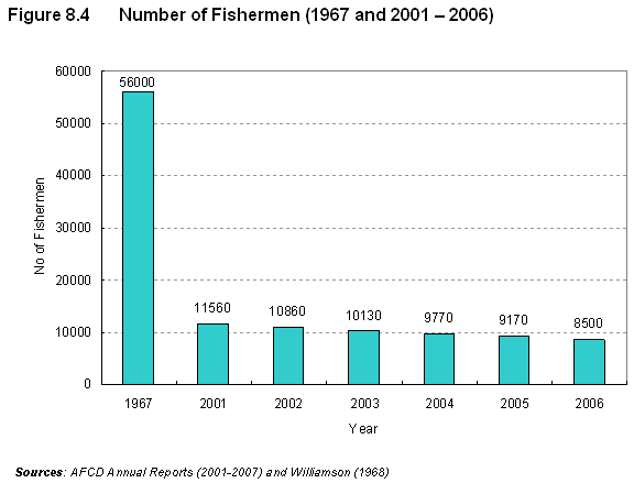
Figure 8.4 Number of Fishermen (1967 and 2001 – 2006)
Figure 8.5 Composition of Fishing Fleet (AFCD, 2001 – 2007)
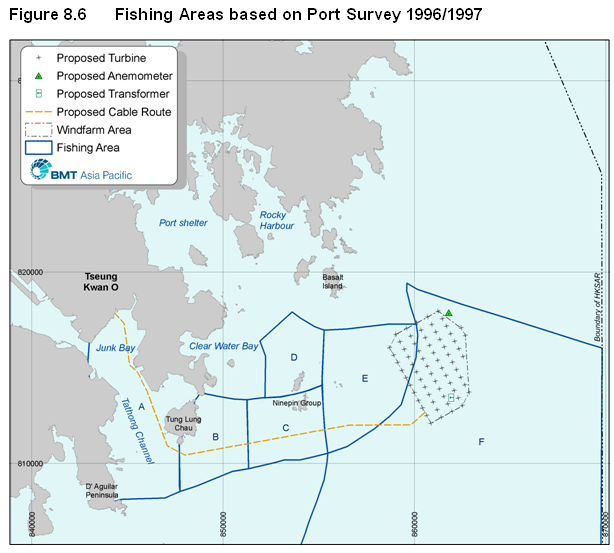
Figure 8.6 Fishing Areas based on Port Survey 1996/1997
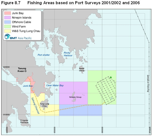
Figure 8.7 Fishing Areas based on Port Surveys 2001/2002 and 2006
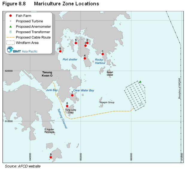
Figure 8.8 Mariculture Zone Locations
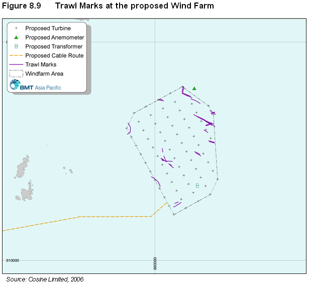
Figure 8.9 Trawl Marks at the proposed Wind Farm
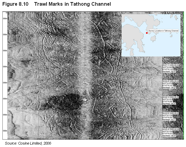
Figure 8.10 Trawl Marks in Tathong Channel
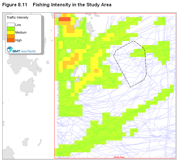
Figure 8.11 Fishing Intensity in the Study Area
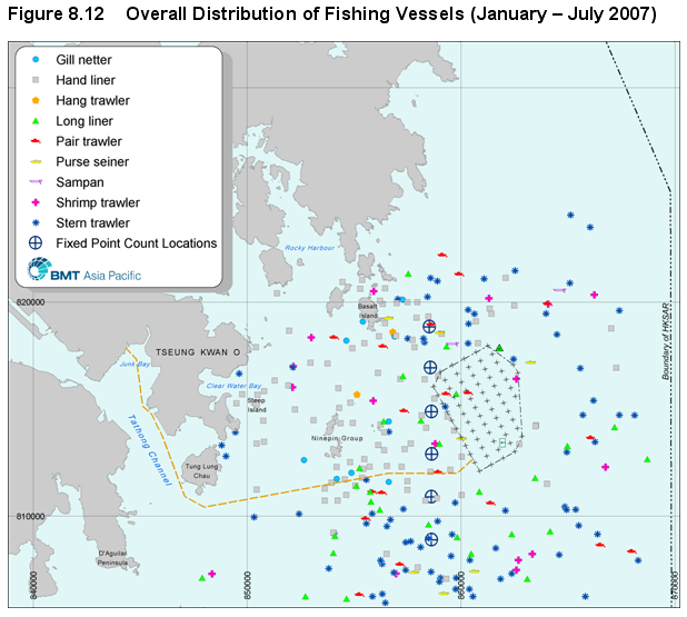
Figure 8.12 Overall Distribution of Fishing Vessels (January – July 2007)
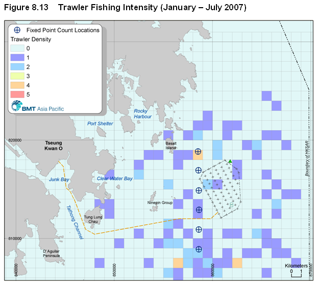
Figure 8.13 Trawler Fishing Intensity (January – July 2007)
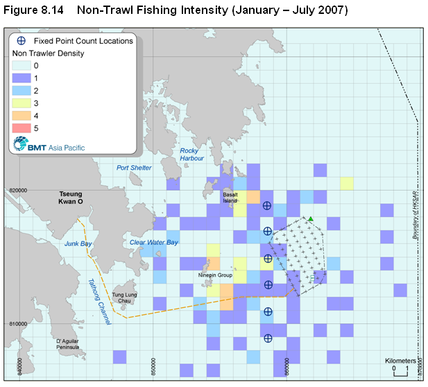
Figure 8.14 Non-Trawl Fishing Intensity (January – July 2007)
Figure 8.15 Homeports of Interviewed Boat Captains
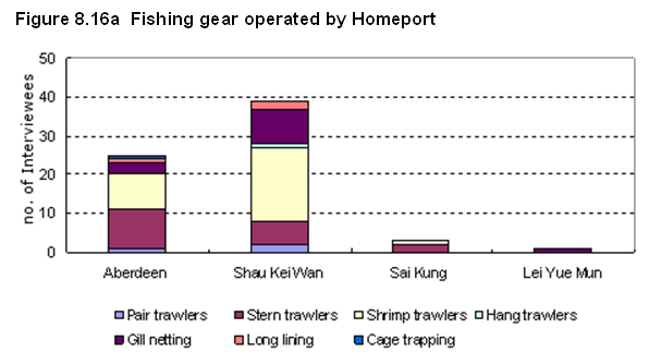
Figure 8.16a Fishing gear operated by Homeport
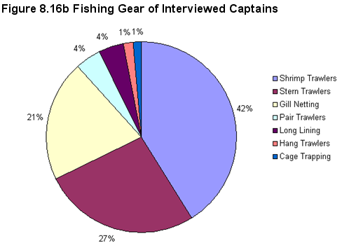
Figure 8.16b Fishing Gear of Interviewed Captains
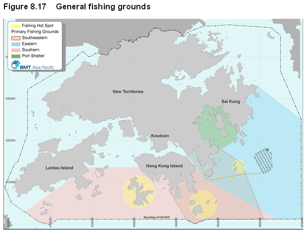
Figure 8.17 General fishing grounds
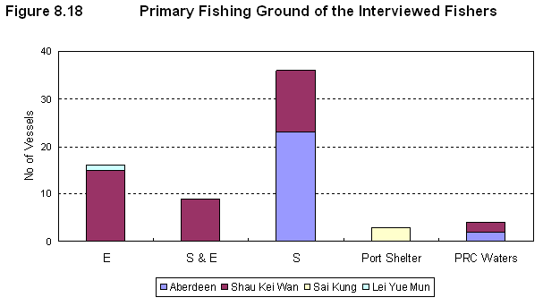
Figure 8.18 Primary Fishing Ground of the Interviewed Fishers
Figure 8.19 Commonly caught species by all respondents
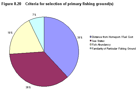
Figure 8.20 Criteria for selection of primary fishing ground(s)
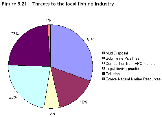
Figure 8.21 Threats to the local fishing industry
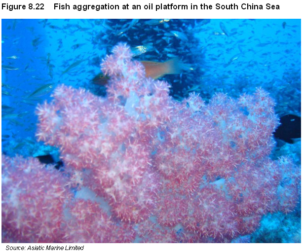
Figure 8.22 Fish aggregation at an oil platform in the South China Sea
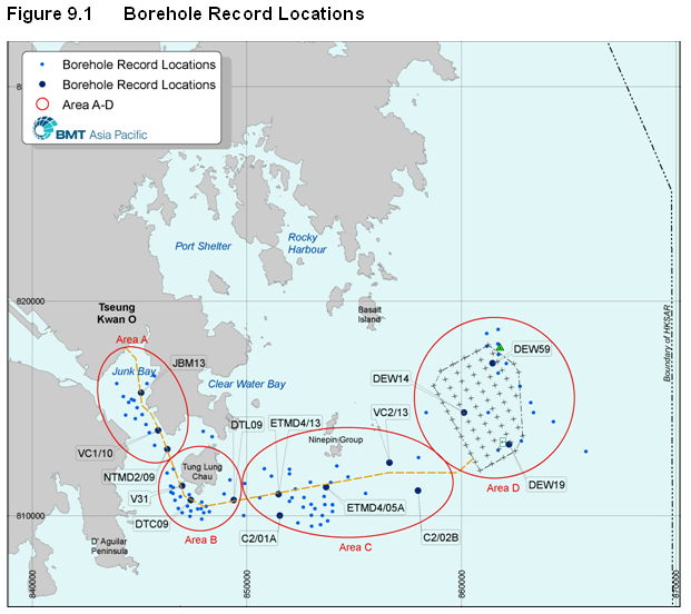
Figure 9.1 Borehole Record Locations
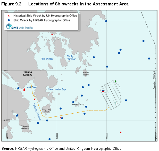
Figure 9.2 Locations of Shipwrecks in the Assessment Area
Figure 9.3 Side-Scan Sonar Survey Transect
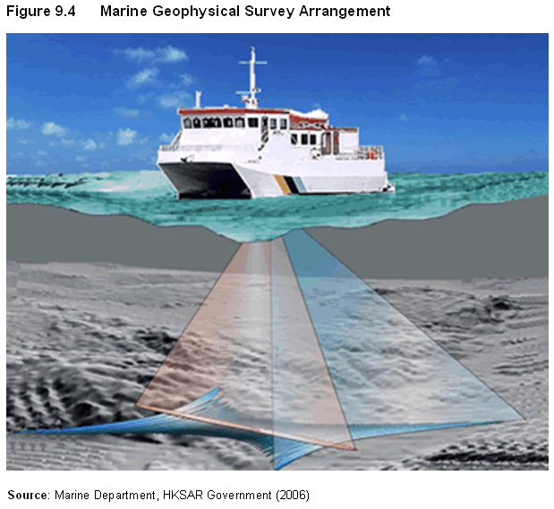
Figure 9.4 Marine Geophysical Survey Arrangement
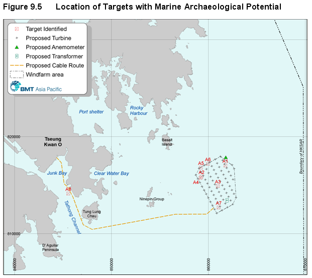
Figure 9.5 Location of Targets with Marine Archaeological Potential
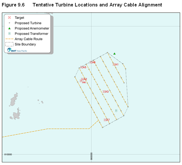
Figure 9.6 Tentative Turbine Locations and Array Cable Alignment
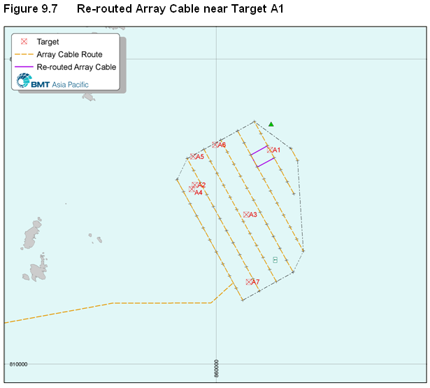
Figure 9.7 Re-routed Array Cable near Target A1
Figure 10.3 Plan of Landscape Resources
Figure 10.4 Plan of Landscape Character Area
Figure 10.5 Photo of Landscape Resources Landscape and Character Area (clear day)
Figure 10.6 Photo of Landscape Resources Landscape and Character Area (cloudy day)
Figure 10.7a 3MW Option Viewpoints and ZVI to Blade Tip
Figure 10.7b 5MW Option Viewpoints and ZVI to Blade Tip
Figure 10.8a Plan of VSR Locations (3MW Option)
Figure 10.8b Plan of VSR Locations (5MW Option)
Figure 10.9a Viewpoint 1 – South China Sea – 3MW Option
Figure 10.9b Viewpoint 1 – South China Sea – 5MW Option
Figure 10.10a Viewpoint 2 – Between North and South Ninepin Islands – 3MW Option
Figure 10.10b Viewpoint 2 – Between North and South Ninepin Islands – 5MW Option
Figure 10.11a Viewpoint 3 – Clearwater Bay Country Club – 3MW Option
Figure 10.11b Viewpoint 3 – Clearwater Bay Country Club – 5MW Option
Figure 10.12a Viewpoint 4 – Clearwater Bay Second Beach Car Park – 3MW Option
Figure 10.12b Viewpoint 4 – Clearwater Bay Second Beach Car Park – 5MW Option
Figure 10.13a Viewpoint 5 – Tai Leng Tung Viewing Area in Clearwater Bay Country Park – 3MW Option
Figure 10.13b Viewpoint 5 – Tai Leng Tung Viewing Area in Clearwater Bay Country Park – 5MW Option
Figure 10.14a Viewpoint 6 – Sail Training Association of Hong Kong – 3MW Option
Figure 10.14b Viewpoint 6 – Sail Training Association of Hong Kong – 5MW Option
Figure 10.15a Viewpoint 7 – Port Shelter – 3MW Option
Figure 10.15b Viewpoint 7 – Port Shelter – 5MW Option
Figure 10.16a Viewpoint 8 – Sam Chau Mun – 3MW Option
Figure 10.16b Viewpoint 8 – Sam Chau Mun – 5MW Option
Figure 10.17a Viewpoint 9 – Pak Lap – 3MW Option
Figure 10.17b Viewpoint 9 – Pak Lap – 5MW Option
Figure 10.18a Viewpoint 10 – High Island Reservoir – 3MW Option
Figure 10.18b Viewpoint 10 – High Island Reservoir – 5MW Option
Figure 10.19a Viewpoint 11 – Tai Cham Koi – 3MW Option
Figure 10.19b Viewpoint 11 – Tai Cham Koi – 5MW Option
Figure 10.20a Viewpoint 12 – Tai Long Wan Beach – 3MW Option
Figure 10.20b Viewpoint 12 – Tai Long Wan Beach – 5MW Option
Figure 10.21 Landscape and Visual Mitigation Measures – Operational Phase
Figure 10.22 Landscape and Visual Mitigation Measures – Operational Phase
Figure 10.23 Residual Landscape Resource Impact in (Pre) Construction Phase
Figure 10.24 Residual Landscape Resource Impact in Operation Phase
Figure 10.25 Residual Landscape Character Impact in (Pre) Construction Phase
Figure 10.26 Residual Landscape Character Impact in Operation Phase
Figure 10.27 Residual Visual Impact in (Pre) Construction Phase
Figure 10.28 Residual Visual Impact in Operation Phase
List of Appendices
Appendix 1A Consulted Project Stakeholder
Appendix 1B Study Brief Checklist
Appendix 2A MNSRA Report Executive Summary
Appendix 4A Calibration Report
Appendix
4B Water Sensitive Receivers
Appendix
4C Allowable SS Elevations for the WSRs
Appendix
4D Predicted Water Quality Results for
Unmitigated Scenarios
Appendix 4E Elutriate Test Results
Appendix
4F Predicted Water Quality Results for
Cumulative Impacts
Appendix
4G Predicted Water Quality Results for
Mitigated Scenarios
Appendix
4H Oil Spill Management Plan
Appendix 5C City University Infauna Report
Appendix 6C Marine Mammal Sighting Sheet
Appendix 7B Collision Probabilities of Selected Species
Appendix
8A Fisheries Questionnaire
Appendix
9A Definition of Targets of
Archaeological Potential