Table of Contents
1. Introduction 8
1.1 Background_ 8
1.2 Objectives
of the EIA Study_ 9
1.3 Structure
of the EIA Report 10
2. Project DescriptionS 11
2.1 Need
of the Project 11
2.2 Consideration
of Alternative Design and Layout 12
2.3 Consideration
of Alternative Construction Methods and Sequences of Works 14
2.4 Selection
of Preferred Scenario_ 16
2.5 Designated
Project 17
2.6 EIA
Study Brief 18
2.7 Construction
Programme 18
2.8 Concurrent
Projects 18
3. Air Quality Impact 20
3.1 Introduction_ 20
3.2 Environmental
Legislation, Standards and Guidelines 20
3.3 Description
of Environment 21
3.4 Air
Sensitive Receivers 24
3.5 Identification
of Representative Air Pollutants 24
3.6 Assessment
Methodology_ 25
3.7 Evaluation
of Environmental Impacts 26
3.8 Mitigation
of Adverse Environmental Impacts 26
3.9 Environmental
Monitoring and Audit Requirements 27
3.10 Conclusion_ 28
4. Noise Impact 29
4.1 Introduction_ 29
4.2 Environmental
Legislation, Standards and Guidelines 29
4.3 Description
of Environment 32
4.4 Identification
of Potential Noise Impact 32
4.5 Noise
Sensitive Receivers 32
4.6 Assessment
Methodology_ 33
4.7 Evaluation
of Environmental Impacts 33
4.8 Evaluation
and Recommendation of Mitigation Measures for Noise 34
4.9 Evaluation
of Residual Impacts 35
4.10 Environmental
Monitoring and Audit Requirements 36
4.11 Conclusion_ 36
5. Water Quality Impact 37
5.1 Introduction_ 37
5.2 Environmental
Legislation, Standards and Guidelines 37
5.3 Description
of the Environment 39
5.4 Water
Sensitive Receivers 42
5.5 Assessment
Methodology_ 43
5.6 Identification,
Prediction and Evaluation of Water Quality Impact 43
5.7 Mitigation
Measures 45
5.8 Evaluation
of Residual Impacts 47
5.9 Environmental
Monitoring and Audit Requirements 47
5.10 Conclusion_ 47
6. Waste Management Implication and Land Contamination 48
6.1 Introduction_ 48
6.2 Relevant
Legislations, Standards & Guidelines 48
6.3 Assessment
Methodology_ 52
6.4 Estimation
of Construction Waste Generation and Evaluation of Impact 52
6.5 Land
Contamination_ 57
6.6 Estimation
of Operational Waste Generation and Evaluation of Impact 60
6.7 Mitigation
Measures 60
6.8 Residual
Impact 62
6.9 Environmental
Monitoring and Audit 62
6.10 Conclusion_ 62
7. Ecological Impact 63
7.1 Introduction_ 63
7.2 Relevant
Legislations, Standards & Guidelines 63
7.3 Study
Area & Ecological Sensitive Receivers 64
7.4 Literature
Review_ 64
7.5 Methodology
for Ecological Surveys 70
7.6 Survey
Results – Habitats 72
7.7 Survey
Results – Flora and Fauna 75
7.8 Evaluation
of Habitat 81
7.9 Identification
of Ecological Impacts 86
7.10 Evaluation
of Ecological Impacts 90
7.11 Recommendations
& Mitigation Measures 96
7.12 Evaluation
of Residual Impacts 97
7.13 Environmental
Monitoring and Audit Programme 97
7.14 Conclusion_ 97
7.15 References 98
8. Landscape and Visual Impacts 100
8.1 Introduction_ 100
8.2 Scope
and Content of Study_ 101
8.3 Relevant
Legislations, Standards & Guidelines 101
8.4 Landscape
and Visual Impact Assessment Methodology_ 105
8.5 Baseline
Conditions 113
8.6 Landscape
Impact Assessment 126
8.7 Visual
Impact Assessment 145
8.8 Cumulative
Impacts 159
8.9 Environmental
Monitoring and Audit 159
8.10 Conclusion_ 160
9. Environmental Monitoring & Audit Requirements 163
9.1 Introduction_ 163
9.2 Air
Quality_ 163
9.3 Noise 163
9.4 Water
Quality_ 163
9.5 Waste
Management 164
9.6 Ecology_ 164
9.7 Landscape
and Visual 165
9.8 Implementation
Schedule 165
10. Conclusion 166
10.1 Introduction_ 166
10.2 Summary
of Environmental Outcomes 168
10.3 Summary
of Environmental Impacts 170
Tables
Table 2.1 Comparison of Bridge Designs
Table 3.1 Hong Kong Air Quality Objectives
Table 3.2 Annual Average Concentration of
Pollutants from Year 2011 to 2015 at EPD’s Air Quality Monitoring Station (Tap
Mun)
Table 3.3 Annual Average Concentration of
Pollutants from Year 2016 to 2020 at Grid [22,28] from PATH model
Table 3.4 Representative Air Sensitive Receivers
Table 4.1 Construction Noise Standards During
Non-Restricted Hours
Table 4.2 Construction Noise Standards during
Restricted Hours
Table 4.3 Area Sensitivity Ratings (ASRs)
Table 4.4 Representative Noise Sensitive Receiver
Table 4.5 Unmitigated Construction Noise Impact,
dB(A)
Table 4.6 Mitigated Construction Noise Impact,
dB(A)
Table 5.1 Summary of Water Quality Objectives for
Southern WCZ
Table 5.2 Water Quality Monitoring Results at
SM11 from 2009 to 2013
Table 5.3 Beach Water Quality Monitoring Results
at Silver Mine Bay Beach from 2009 to 2013
Table 5.4 Summary of Water Quality Monitoring
Data for Mui Wo River from 2009 to 2013
Table 6.1 Sediment Quality Criteria for the
Classification of Sediment
Table 6.2 Summary of Waste
Table 6.3 Historical Change in
Wang Tong River and its vicinity
Table 7.1 Plant Species of Conservation
Importance Recorded in Past Studies within/near the Study Area
Table 7.2 Avifauna Species of Conservation
Importance Recorded in Past Studies within/near the Study Area
Table
7.3 Amphibian Species of
Conservation Importance Recorded in Past Study in/near the Study Area and their
Distribution in Hong Kong
Table
7.4 Plant Species with Conservation
Statuses Recorded within the Study Area in Recent Surveys
Table
7.5 Avifauna species of
Conservation Importance Recorded within the Study Area in Recent Surveys
Table
7.6 Fish Species of Conservation
Importance Recorded within the Study Area in Recent Surveys
Table 7.7 Ecological Value of Watercourse – Wang
Tong River
Table 7.8 Ecological Value of Watercourse – River
Silver & Minor Watercourses
Table 7.9 Ecological Value of Developed Area and
Sandy Shore
Table 7.10 Ecological Value of Woodland and Marsh
Table 7.11 Ecological Value of Abandoned
Agricultural Land and Shrubland/Grassland
Table 7.12 Ecological Value of Marine Water
Table 7.13 Summary
of Habitat Loss
Table 7.14 Evaluation of the Significance of
Ecological Impact on Watercourse – Wang Tong River
Table 7.15 Evaluation of the Significance of
Ecological Impact on Watercourse – River Silver & Minor Watercourses
Table 7.16 Evaluation of the Significance of
Ecological Impact on Developed Area and Sandy Shore
Table 7.17 Evaluation of the Significance of
Ecological Impact on Woodland & Marsh
Table 7.18 Evaluation of the Significance of
Ecological Impact on Abandoned Agricultural Land & Shrubland/Grassland
Table
7.19 Evaluation of the Significance
of Ecological Impact on Marine Water
Table
7.20 Evaluation of the Significance
of Ecological Impact on Faunal and Floral Species with Conservation Importance
Table
8.1 Relationship between Receptor
Sensitivity and Magnitude of Change in Defining Impact Significance
Table
8.2 Landscape Resources
Table
8.3 Landscape Character Areas
Table
8.4 Key Visually Sensitive
Receivers (VSRs)
Table
8.5 Magnitude of Landscape Change
during the Construction and Operation Phases before Mitigation
Table
8.6 Proposed Construction Phase
Landscape and Visual Mitigation Measures
Table
8.7 Proposed Operation Phase
Landscape and Visual Mitigation Measures
Table
8.8 Significance of Landscape
Impacts in Construction and Operation Phases
Table
8.9 Magnitude of Visual Change
during the Construction and Operation Phases before Mitigation
Table
8.10 Significance of Visual Impacts
in the Construction and Operation Phases
Figures
Figure
1.1 Location of Project Site
Figure 1.2 Layout of Proposed New Bridge
Figure 2.1 Layout of Proposed New Bridge in Project
Profile
Figure
2.2 Layout of Alternative Bridge
Design (Option 2)
Figure
2.3 Location of Excavation below
High Water Mark
Figure
2.4 Layout of Cofferdam
Figure 3.1 Location of Air Sensitive Receivers
Figure 3.2 Hoarding Plan
Figure 4.1 Location of Noise Sensitive Receiver
Figure 5.1 Location of Water Sensitive Receivers
Figure 7.1 Ecological Survey Plan
Figure
7.2 Habitat Map, Locations of
Species with Conservation Importance and Locations of Nesting Sites
Figure
7.3 Excavation and Habitat Loss
Areas
Figure 8.1 Landscape Study Area
Figure 8.2 Review of Planning Framework
Figure 8.3 Landscape Resources
Figure
8.4.1 Landscape Resources Photographs
(1 of 5)
Figure
8.4.2 Landscape Resources Photographs
(2 of 5)
Figure 8.4.3 Landscape Resources Photographs (3 of 5)
Figure 8.4.4 Landscape Resources Photographs (4 of 5)
Figure 8.4.5 Landscape Resources Photographs (5 of 5)
Figure 8.5 Landscape Character Areas
Figure 8.6 Landscape Character Areas Photographs
Figure 8.7.1 Key Visual Elements
Figure
8.7.2 Zone of Visual Influence (ZVI)
and Visually Sensitive Receivers (VSRs)
Figure
8.8.1 Visually Sensitive Receiver
Photographs (1 of 3)
Figure
8.8.2 Visually Sensitive Receiver
Photographs (2 of 3)
Figure
8.8.3 Visually Sensitive Receiver
Photographs (3 of 3)
Figure
8.9 Residual Impacts on Landscape
Resources with Mitigation at Year 10
Figure
8.10 Residual Impacts on Landscape
Character Areas with Mitigation at Year 10
Figure
8.11 Residual Impacts on VSRs with
Mitigation Year 10
Figure
8.12.1 Photomontage Viewpoint P1: View
East from Chung Hau (1 of 2)
Figure
8.12.2 Photomontage Viewpoint P1: View
East from Chung Hau (2 of 2)
Figure
8.13.1 Photomontage Viewpoint P2: View
West from Silver Mine Bay Beach (1 of 2)
Figure
8.13.2 Photomontage Viewpoint P2: View
West from Silver Mine Bay Beach (2 of 2)
Figure
8.14 Photomontage Viewpoint P3: View
North West from Silver Mine Bay Waterfront
Figure
8.15 Photomontage Viewpoint P4: View
North West from Silver Mine Bay
Figure
8.16 Photomontage Viewpoint P5: View
South West from Tung Wan Tau
Figure
8.17 Landscape and Visual Mitigation
Measures
Appendices
Appendix
2A Preliminary Work Programme
Appendix
2B Potential Concurrent Projects
Appendix 4A Construction Plan Inventory (Unmitigated
Scenario)
Appendix 4B Unmitigated Sound Power Level of Construction
Activities
Appendix 4C Unmitigated Construction Noise Level of the
Project at NSR
Appendix 4D Summary of Unmitigated Construction Noise
Level of the Project
Appendix 4E Construction Plan Inventory (Mitigated
Scenario)
Appendix 4F Mitigated Sound Power Level of Construction
Activities
Appendix 4G Mitigated Construction Noise Level at NSR
Appendix 4H Detailed Calculation of Mitigated
Construction Noise Level of the Project
Appendix 4I Photographic Record of Representative Noise
Sensitive Receiver
Appendix 6A Representative Historical Photos
Appendix
6B Representative Photos of Current Land
Uses
Appendix
6C Chemical Waste Producer, Dangerous
Goods & Incident Records
Appendix
6D Extract of GI Record
Appendix
7A Representative Photos of Habitats in
the Study Area
Appendix 7B Species List
Appendix
7C Photographic Record of Species with
Conservation Concern
Appendix
7D Photographic Record of the Project
Site
Appendix 7E Distribution of Marine Mammals
Appendix
8A Tree Survey Results and
Recommendations
-
MLAL1 –
TS01 - Tree Recommendation Plan
-
MLAL1 –
CP01 – Compensatory Planting Plan
-
Tree
Assessment Schedule
-
Tree
Survey Photographs
Appendix 8B Concurrent Projects
Appendix
9 Implementation Schedule
Appendix
10 Summary of Environmental Impacts
Appendix 11 Compliance Checklist – Study Brief
Document No. HA927/EIA_Final_v4.0
|
Final
(Version 4.0)
|
July 2016
|
MLAL/Cinotech
|
MLAL
|
|
Revision
|
Date
|
Prepared
|
Checked
|
Agreement
No. CE 14/2014 (HY) – New Wang Tong River Bridge, Mui Wo Environmental Impact
Assessment and Drainage Impact Assessment
Environmental
Impact Assessment Report (Final)
1.1.1
Silver Mine Bay is a popular bathing beach in
Mui Wo, Lantau that attracted 4,550 visitors on a peak day and over 69,000
visitors utilized the beach in 2012.
1.1.2
In order to relieve the overcrowding problem
and the road safety concern of Wang Tong Bridge (hereafter called “Old
Bridge”), two bridges (pedestrian bridge and cycle bridge) are proposed to
replace the Old Bridge. The new pedestrian bridge and the new cycle bridge
(hereafter called “New Bridge”) are also designed to align with the future
amenity development on the northern side of the Old Bridge. The location of the
project site is shown in Figure 1.1.
1.1.3
This Project mainly comprises the following
works:
i.
Construction
of a new cycle bridge next to the existing bridge
ii.
Demolition
of the existing bridge
iii.
Construction
of a new pedestrian bridge on the same site of the existing bridge
1.1.4
Based on the current design, both New Bridges
will be supported by columns outside the river. The preliminary layout of the
New Bridges prepared by the Highways Department (HyD) is shown in Figure
1.2.
1.1.5
The Project consists of the following
designated projects under Part I, Schedule 2 of the Environmental Impact
Assessment Ordinance (EIAO):
·
Item C.12 – (a)…a dredging operation which is
less than 500m from the nearest boundary of an existing…(iii) bathing beach…
1.1.6
A project profile (PP-478/2013) has been
submitted to Environmental Protection Department in 28 January 2013 and a study
brief (ESB- 256/2013) has been issued to HyD in March 2013.
1.1.7
As an environmental impact assessment (EIA)
is required under the Environmental Impact Assessment Ordinance (EIAO), HyD
appointed the Joint Venture of Maurice Lee and Associates Ltd. and Cinotech
Consultants Ltd. (hereinafter called the JV) to perform the EIA study
accordingly.
1.2.1
The key objectives of the EIA Study are to
identify key environmental issues and constraints of the major elements of the
Project and to consider possible environmental impact of the schemes and
appropriate measures. The detailed objectives are listed as follows:-
(i)
To describe the Project and associated
works together with the requirements and environmental benefits for carrying
out the Project and the types of designated projects to be covered by the
Project;
(ii)
To identify and describe
elements of community and environment likely to be affected by the Project
and/or likely to cause adverse impact to the Project, including natural and
man-made environment and the associated environmental constraints;
(iii)
To provide information on
the consideration of alternatives design options of the Project including
scale, extent, layout, configuration, design and type of design orientation and
the construction methods with a view to avoiding and minimizing potential
environmental impacts to environmentally sensitive areas and sensitive uses; to
compare the environmental benefits and dis-benefits of different options; to
provide reasons for selecting the preferred option(s) and to describe the part
environmental factors played in the selection of preferred option(s);
(iv)
To identify and quantify emission sources
(including air quality, noise, water quality and waste, etc. as appropriate) and
determine the significance of impact on sensitive receivers and potential
affected uses;
(v)
To identify and quantify
any potential losses or damage and other potential impacts to ecology, flora, fauna
and natural habitats and to propose measures to mitigate these impacts;
(vi)
To identify any potential
landscape and visual impacts and to propose measures to mitigate this impact;
(vii)
To propose provision of
infrastructure or mitigation measures so as to minimize pollution,
environmental disturbance and nuisance during construction and operation of the
Project;
(viii)
To investigate the
feasibility, practicability, effectiveness and implications of the proposed
mitigation measures;
(ix)
To identify, predict and
evaluate the residual environmental impact (i.e. after practicable mitigation)
and the cumulative effects expected to arise during construction and operation
phases of the Project in relation to the sensitive receivers and potential
affected uses;
(x)
To identify, assess and
specify methods, measures and standards, to be included in the detailed design,
construction and operation of the Project which are necessary to mitigate these
environmental impacts and cumulative effects and reduce them to acceptable
levels;
(xi)
To investigate the extent
of the secondary environmental impact that may arise from the proposed
mitigation measures and to identify constraints associated with the mitigation
measures recommended in the EIA study, as well as the provision of any
necessary modification; and
(xii)
To design and specify
environmental monitoring and audit requirements to ensure the effective
implementation of the recommended environmental protection and pollution
control measures.
1.3.1
The EIA report presents the environmental
impact that may arise from the Project and the associated mitigation measures,
as follows:-
l
Chapter 1 (Introduction) –
Introduces the background information and the layout of the EIA Report;
l
Chapter 2 (General) – Project
Description;
l
Chapter 3 (Air Quality
Impact) – Presents the legislation, methodology, assessment and recommendations
for air quality impact;
l
Chapter 4 (Noise Impact) –
Presents the legislation, methodology, assessment and recommendations for noise
impact;
l
Chapter 5 (Water Quality
Impact) – Presents the legislation, methodology, assessment and recommendations
for water quality impact;
l
Chapter 6 (Waste
Management) –Presents the legislation, methodology, assessment and
recommendations for waste management;
l
Chapter 7 (Ecological
Impact) – Presents the legislation, methodology, assessment and recommendations
for ecological impact;
l
Chapter 8 (Landscape and
Visual Impact) – Presents the legislation, methodology, assessment and recommendations
for landscape and visual impact;
l
Chapter 9 (EM&A
Requirements) – Presents the EM&A requirements; and
l
Chapter 10 (Conclusion) –
Summarizes the findings.
2.1.1
Silver Mine Bay is a popular bathing beach in
Mui Wo, Lantau. According to the EPD’s “Beach Water Quality in Hong Kong 2012”,
the beach attracted 4,550 visitors on a peak day and over 69,000 visitors
utilized the beach in 2012. The shortest route from the pier to this beach is
by crossing the Wang Tong Bridge (hereafter called “Old Bridge”).
2.1.2
During holidays, people enjoy cycling around
Mui Wo for sightseeing. As the bridge is only about 1.5m wide, overcrowding
problem occurs and pedestrians and cyclists are often crossing the bridge
shoulder to shoulder. According to Civil Engineering Development Department
(CEDD)’s “Improvement Works for Mui Wo Facelift – Feasibility Study” in 2007,
the hourly peak flow of the Old Bridge was 650 pedestrians and 250 bikes. This
also raises concern on the risk of accident caused by pedestrians being hit by
bicycles.
2.1.4
The purpose, objectives and benefits of
project are as follows:
l Demolish
the Old Bridge and construct a wider New Bridge (including deck, abutments and
retaining walls) with segregation for pedestrians and cyclists to relieve
overcrowding problem and road safety concern
l CEDD
planned to improve the existing segregated cycle track and footpath on the
southern side of the Old Bridge and provide cycle parking area on the northern
side of the Old Bridge. The New Bridge design is also suggested to align with
the future development on both sides of the bridge for continuity.
l Carry
out associated works including drainage works (e.g. u channel & catch pit),
traffic aids (e.g. road paint) and street lighting modification (e.g. lighting
column & lighting meter cabinet), environmental mitigation measures and
landscaping works.
l The
ground level of the Old Bridge is about 3.5 mPD. The water level of the Wang
Tong River under heavy rain and high tide is about 2.36 mPD. This raises safety
concern to the pedestrians of the Old Bridge in case of extreme weather.
Therefore, the deck level of New Bridge shall be raised.
Alternative
Alignment
2.2.1
As mentioned in Section 2.1.3 above, improving
the existing bridge is not cost effective or
technically practical due to its poor condition. Keeping the Old Bridge is also not preferred
due to substandard design to cater for adverse drainage situation (see Section 2.1.5). Therefore,
the Old Bridge shall be replaced by a new bridge.
2.2.2
In total, three New Bridge options were proposed:
l Alignment Option 1 – One Single Bridge with Intermediate Bridge Support
below high water mark (Design in the TFS and used in Project Profile
PP-478/2013) (Figure 2.1)
l Alignment Option 2 – One Single Bridge with no Intermediate Bridge
Support (Figure 2.2)
l Alignment Option 3 – Two Separated Bridges with Intermediate Supports
above high water mark (Preferred design in this EIA) (Figure 1.2)
2.2.3
Option
1 is a design proposed in TFS, Project Profile
and Study Brief. It consists of a single 6.35m wide bridge with approach
footway and cycle track to replace the Old Bridge. The new bridge will be
supported by one intermediate support below high water mark in Wang Tong River. This
scheme satisfies the functional and layout requirements; however, some of the
drawbacks are explained below:
l
The structure is bulky and visually
unattractive;
l
Heavy foundation requires
the use of large scale piling rigs, occupying more amenity area of the beach,
requiring longer approach ramps at the north side and clashing more existing
trees;
l
The levels of the footpath
and cycle track on both approaches are higher than the existing formation level
with steep ramps and sharp bends. Substantial site formation works involving
modification and strengthening of the existing seawalls and retaining walls are
required.
2.2.4
In summary, this design has low structural
efficiency with adverse implications on constructability, geotechnical,
drainage and environmental impacts and cost. Furthermore, there is room for
improvement in the functional and layout arrangement and landscape and visual
impacts.
2.2.5
In Option 2, a single bridge
with no intermediate support was proposed to replace the Old Bridge. The
advantages of this Option will be reducing environmental and drainage impacts
by removing the need for channel dredging, reducing deck thickness, and increasing
the freeboard below. However, this Option will require an
increased deck span with implications for bridge structural form, support and
foundations. The disadvantage of these will be result in a much larger visual
profile than a concrete beam construction.
2.2.6
In Option
3, two separated bridges with intermediate support outside the river was
proposed to replace the Old Bridge. The advantages of
this Option include,
l providing
complete separation of cycle track and footpath,
l providing
an efficient and safe transition such that building lots abut on the footpath
instead of bicycle rack and the cycle track,
l minimizing
privacy and security concerns to Silver Mine Bay on the south side by designing
the deck level below which bridge user can overlook the interior of hotel,
l providing
slimmer New Bridge that reduces the extent of ramp modification and
strengthening at both ends and provides adequate freeboard to Wang Tong River,
l avoiding
substantial surcharge to existing seawalls and retaining walls,
l minimising
construction and demolition works below high water mark (HWM) within Wang Tong
River,
l improving
drainage performance by eliminating pier of the Old Bridge and raising the
soffit of the bridge further above water
l reducing
the length of approach ramp which would be received better by the public.
2.2.7
A comparison table on the potential
environmental impacts between the three options is shown below:
Table 2.1: Comparison of
Bridge Designs
|
Considerations
|
Option
1
|
Option
2
|
Option
3
|
|
No.
of Pier
|
1
|
0
|
1
|
|
Location
of Pier
|
Center
of River
|
N/A
|
Above
high water mark
|
|
Dredging
*
|
Yes
|
No
|
Yes,
but less than Option 1
|
|
Blockage
of River Flow
|
Permanent
partial blockage by new pier
|
No
central pier, no additional permanent
blockage of river flow
|
New Pier
above high water mark, no additional
permanent blockage of river flow
|
|
Felling
of Trees
|
More
|
Fewer
|
Fewer
|
|
Impact
on Naturalness
|
-
Minor loss in sandy shore
- Minor permanent loss in river bed by new pier
|
-
Minor loss in sandy shore
- No additional loss of river bed
|
-
Minor loss in sandy shore
- No additional loss of river bed
|
|
Landscape
and Visual Impact
|
Bulkier
than Old Bridge
|
Bulkier
than Old Bridge
|
Each new bridge is of similar bulkiness as Old
Bridge
|
|
Note: * Exclude removal of Old Bridge
pier
- Better options are bolded
|
|
|
|
|
|
|
|
|
|
|
2.2.8
Table
2.1 shows that Option 1 is expected to bring the
greatest impact out of the three options. Both Option 2 and 3 will not cause additional
permanent blockage of Wang Tong River and river bed and fewer impact on trees.
Although Option 2 does not involve dredging works for construction of new pier,
the overall design is much bulkier than Option 3 (i.e. 1.4 m deck thickness in
Option 2 comparing to 0.9 & 1.2 m deck thicknesses in Option 3) so that the
bridge can sustain its structure without pier support. Adverse opposition from
locals is expected due to significant visual impact. The pier of Option 3 is
located above high water mark and thus only minor dredging works will be
involved. Given Option 3 is more favourable than the other two, the New Bridge
design with two separated bridges is therefore
selected as being suitable to take forward.
2.3.1
Construction of New Bridge and demolition of
Old Bridge involves the following major activities:
·
Demolition
works
·
Piling
·
Dredging/Excavation
and backfilling
·
Bridge
building (formation of bridge structure and concreting)
Alternative Construction Methods
Consideration of “No-dredge Option”
2.3.2
Possibility of cutting the central pier of
the Old Bridge down to the riverbed surface only has been explored. However, Drainage
Services Department requested further cutting for better drainage performance.
Therefore, removal of Old Bridge pier down to 300mm below riverbed requiring
dredging works was proposed. This design received no further departmental
comment.
Demolition of Central Pier of Old Bridge
2.3.3
Cutting and breaking are typical demolition
methods. Alternative demolition method of the central pier of Old Bridge within
the HWM is by application of strong acid solution, e.g. nitric acid, to
dissolve the mild steel bars under seabed level. However, this raises concern
on the potential leakage of strong acid into Wang Tong River, causing
undesirable water quality impact on this ecologically sensitive habitat and the
bathing beach downstream. Therefore, demolition of pier by cutting is adopted.
Piling
2.3.4
Bored piling is a common method in bridge
pier construction. However, given the limited space at the river bank and
popular usage of the gazetted beach, use of large bored piling machine is not
preferred. Also, bored piling involves extensive excavation work before
placement of large diameter bored piles. Much dredged/excavated materials and
wastewater will be generated.
2.3.5
A more environmentally friendly method
minipiling is proposed. Minipiling machine is much smaller and thus less space
demanding. It will be easier to be delivered to the Site as well. Only small
scale excavation work will be needed for driving minipiles into soil, thus
generating less excavated materials and wastewater.
Excavation Area of Abutment/Pier of New
Bridge
2.3.6
In order to construct minipiles for the new
bridges, fully enclosed cofferdam constructed from sheet piles will be
installed around the pier with 1m clearance from pile cap. Excavation/dredging
will be conducted within cofferdam. The works area of the southern abutment and
central pier of the new bridges may fall within the HWM.
2.3.7
For new cycle bridge, the works area of the
southern abutment and central pier of the will be within the HWM by 0.22 m2
and 1.10 m2 respectively.
2.3.8
For new pedestrian bridge, the existing
abutments and pile caps will be demolished before construction of the new
bridges at the same location. The works area of the southern abutment and
central pier of the new cycle bridge will be within the HWM by 3.30 m2
and 3.64 m2 respectively.
2.3.9
While construction at the HWM is required,
the water level may not always reach the work site depending on the tidal
phase. Therefore, the excavation/dredging at the abutment within HWM during the
construction period may be conducted in dry condition.
Bridge Construction
2.3.10
Sections of structural steel (7m x 1m) shall
be delivered to the Site. The steel sections will be prefabricated in the
northern part of works area. The bridge section will then be moved to the proposed
bridge location for erection and concreting. This can minimize the activity
above water and the chance of dropping debris into water.
Sequences of Works
2.3.11
To minimize the number of concurrent
activities, construction and demolition works will be carried out in sequence:
(1) Construction of new cycle bridge
(2) Demolition of Old Bridge
(3) Construction of new pedestrian bridge
2.3.12
Although the duration of work will be
prolonged, slow work process requires fewer plant equipment and thus produce
less noise nuisance.
Preferred Design and Layout
2.4.1
The preferred bridge layout is a twin bridges
design having one supporting pier above high water mark (Option 3). This design is beneficial in terms of pedestrian/cyclist
safety as well as overall smaller environmental impact:
·
no
permanent damage on riverbed or obstruction of river flow;
·
fewer
impact on trees during construction;
·
smaller
landscape and visual impact by having low profile and design that matches with
surrounding rural environment.
2.4.2
The deck of the New Bridge is designed at
about 5.40mPD highest with 0.3m freeboard, which is capable of passing 1 in 100
year flooding.
Preferred Construction
Methods
2.4.3
Minipiling will be adopted for constructing foundation
of the New Bridge, which requires smaller space for accommodating the piling
machine and this method also generates fewer excavated materials than
traditional bored piling.
2.4.4
Dredging/Excavating below high water mark
cannot be avoided at the pier of Old Bridge in order to improve drainage
performance of Wang Tong River. However, fully enclosed cofferdam will be
installed around the piling and pier demolition works area to prevent
dispersion of dredged/excavated materials into water.
2.4.5
Existing pile cap at southern abutment of
pedestrian bridge is proposed to be demolished.
Detailed Construction
Methods
2.4.6
The construction method of the Project can be
divided into 3 major parts: 1.) construction of the new cycle bridge, 2.) demolition
of old bridge, and 3.) construction of new pedestrian bridge.
Construction
of New Bridge (Both cycle and pedestrian bridges)
2.4.7
Procedures for constructing the New Bridge
would be as follow:
(1) Install mini-piles by boring machine with
steel casing at abutments and column support above High Water Mark (HWM);
(2) Perform loading test for mini-piles;
(3) Install shoring work for excavation of pile
cap;
(4) Construct pile cap, abutments and column;
(5) Remove temporary shoring works and
backfilling;
(6) Erect structural steel truss / girder
between column and abutment as temporary works for bridge construction;
(7) Erect steel beams and cast concrete deck;
and
(8) Complete all finishes and street furniture.
Demolition
of Old Bridge
2.4.8
Procedures for demolishing the Old Bridge
would be as follow:
(1) Demolish spine beam by hand held tools;
(2) Install cofferdam around old pier (1m
clearance from old pier, i.e. about 2.4 x 2.8m2);
(3) Adjust
working platform and demolish RC (reinforced concrete) column down to 300mm
above river bed level by either hand held tools or saw cutting;
(4) Further
cut the concrete down to 300mm below river bed level by hand held percussive
pneumatic tools, cut the reinforcement and mild steel bars down to 300mm below
river bed level by pneumatic saw;
(5) Fill
the hole in the river bed with the demolished concrete;
(6) Remove
cofferdam around old pier;
(7) Install
cofferdam around existing abutments;
(8) Demolish the top level of existing abutments
down to about 3.2mPD;
(9) Trim the existing abutments to act as
seawall
(10) Remove cofferdam around abutment.
2.5.1
The Project consists of the following
designated projects under Part I, Schedule 2 of the Environmental Impact
Assessment Ordinance (EIAO):
·
Item C.12 – (a)…a dredging operation which is
less than 500m from the nearest boundary of an existing…(iii) bathing beach…
2.5.2
Silver Mine Bay Beach is a gazetted bathing
beach and just located next to the Project site. According to the construction
method, the piers/abutments for the new bridges will be constructed within high
water mark. Excavation area below high water mark (i.e. dredging operation)
will be needed for the construction of these piers/abutments. The excavation
area is hatched in cyan in Figure 2.3 and
intended quantity is approximately 323m3.
2.6.1
A project profile (PP-478/2013) has been
submitted by Highways Department to Environmental Protection Department on 28
January 2013 and a study brief (ESB- 256/2013) has been issued to HyD in March
2013.
2.7.1
As access across Wang Tong River has to be
maintained during construction period, the new cycle bridge will be constructed
first before demolition of the Old Bridge and subsequent construction of new
pedestrian bridge.
2.7.2
The construction work is expected to last for
two years from mid-2017 to mid-2019. The proposed breakdown of programme can be
found in Appendix 2A.
2.8.1
Currently, there are one planned and one
ongoing projects within the Study Area.
(1) Signature Project Scheme (Islands District)
– Improvement Works at Silvermine Bay Beach, Mui Wo, Lantau Island by the Home
Affairs Department (HAD); and
(2) Upgrading of Mui Wo Sewage Treatment Works and
Village Sewerage at Wang Tong and Yue Kwong Chuen managed by the Drainage
Services Department (DSD).
2.8.2
The latest status and activities that are
predicted to overlap with the work programme of this Project have been sought
from respective project engineers/architects. Details are attached in Appendix 2B.
2.8.3
The scope of HAD project is as follows:
(a) demolition of the existing beach service
buildings;
(b) construction of new beach buildings and
associated beach facilities with an approximate construction floor area of 938
m2;
(c) construction of new barbeque pit area and
sitting-out area; and
(d) construction of a viewing deck near the
entrance to the beach.
2.8.4
The anticipated construction period is
January 2016 – January 2017, which will not overlap with this Project (to be
commenced in second half of 2017).
2.8.5
The scope of DSD project is as follows:
(a) upgrading of existing Mui Wo Sewage
Treatment Works
(b) upgrading of truck sewers along Ngan Kwong
Wan Road from 450mm dia. to 750mm
(c) village sewerage at Wang Tong village and
Yue Kwong Chuen
2.8.6
Only Scope (c) is located in the vicinity of
Wang Tong River Bridge. Sewer laying and manholes construction works were
substantially completed and reinstatement works is in progress. The outstanding
activities are as follows:
(i) Reinstatement of the roadside covered
U-channel, cycle track and footpath pavements (to be completed by end of
December 2015);
(ii) The pipe cleaning and CCTV;
(iii) Painting of manhole internal wall face with
epoxy paint (will be carried out in mid-2017).
2.8.7
Activity (ii) and (iii) of the DSD project
may overlap with this Project in mid-2017. Nevertheless, these are minor works
that do not involve use of powered plant equipment or dusty works. No
cumulative impact is expected.
3.1.1
This Chapter assesses potential air quality
impact arising from both construction and operation of the Project. Where
necessary, mitigation measures have been proposed and their effectiveness has
been evaluated.
3.2.1
The Air Pollution Control Ordinance (Cap. 311) provides for the control of air pollutants from a
variety of stationary and mobile sources through the establishment of a set of Air Quality Objectives (AQOs). Since 1st January 2014, a new set of air
quality objectives which stipulates maximum concentrations for a range of pollutants,
i.e. nitrogen dioxide (NO2), sulphur dioxide (SO2),
respirable suspended particulates (RSP), fine suspended particulates, carbon monoxide (CO), photochemical oxidants (O3)
and lead (Pb),
has been in force.
Details of AQOs are listed in Table 3.1.
Table
3.1: Hong Kong Air Quality Objectives
|
Pollutant
|
Averaging time
|
Concentration limit [i] (μg/m3)
|
Number of exceedances allowed
|
|
Sulphur
dioxide
|
10-minute
|
500
|
3
|
|
24-hour
|
125
|
3
|
|
Respirable
suspended particulates (PM10) [ii]
|
24-hour
|
100
|
9
|
|
Annual
|
50
|
Not applicable
|
|
Fine
suspended
particulates
(PM2.5) [iii]
|
24-hour
|
75
|
9
|
|
Annual
|
35
|
Not applicable
|
|
Nitrogen
dioxide
|
1-hour
|
200
|
18
|
|
Annual
|
40
|
Not applicable
|
|
Ozone
|
8-hour
|
160
|
9
|
|
Carbon
monoxide
|
1-hour
|
30,000
|
0
|
|
8-hour
|
10,000
|
0
|
|
Lead
|
Annual
|
0.5
|
Not applicable
|
Note:
[i] All
measurements of the concentration of gaseous air pollutants, i.e. sulphur
dioxide, nitrogen dioxide, ozone and carbon monoxide, are to be adjusted to a
reference temperature of 293 Kelvin and a reference pressure of 101.325
kilopascal.
[ii] Respirable suspended particulates means suspended particles
in air with a nominal aerodynamic diameter of 10 μm or less.
[iii] Fine suspended particulates means suspended particles in air
with a nominal aerodynamic diameter of 2.5 μm or less.
3.2.2
Criteria and guidelines in Annex 4 and Annex
12 of the Technical Memorandum on Environmental Impact Assessment Process
(EIAO-TM) will be followed for evaluating air quality impacts. Annex 4 stipulates
criteria for evaluating air quality impacts. This includes compliance of the
Air Quality Objectives (AQOs) and other standards established under the Air
Pollution Control Ordinance, as well as meeting the hourly Total Suspended
Particulate concentration of 500 µg/m3 and the 5-second average
odour concentration of 5 odour units (ou). Annex 12 provides guidelines
for conducting air quality assessments under the EIA process, including
determination of air sensitive receivers, assessment methodology and impact
prediction and assessment.
3.2.3
For construction dust, Annex 4 of EIAO-TM
specifies a TSP limit concentration averaged over a 1-hour period to be 500
µg/m3. Mitigation measures for construction sites have been
specified in the Air Pollution Control (Construction Dust) Regulation. It also requires Contractors and site agents
to inform EPD and adopt dust reduction measures while carrying out “Notifiable
Works” or “Regulatory Works” as defined under the regulation. Works relevant to this Project include both
“Notifiable Works” (road construction) and “Regulatory Works” (dusty materials
handling, excavation).
3.2.4
The Air Pollution Control (Non-road Mobile
Machinery) (Emission) Regulation covers non-road mobile machinery (NRMMs)
include a wide range of mobile machines (including transportable industrial
equipment), or vehicles powered by internal combustion engines used primarily
off-road. All regulated machines sold or leased for use in Hong Kong, except
those exempted, are required to comply with the prescribed emission standards.
Starting from 1 December 2015, only approved or exempted NRMMs with a proper
label are allowed to be used in specified activities and locations including
construction sites, container terminals and back up facilities, restricted areas
of the airport, designated waste disposal facilities and specified processes.
3.3.1
The bridge is located in a rural area to the south
of Silver Mine Bay Beach and to the north of Mui Wo, Lantau. The bridge runs
over Wang Tong River from north to south. To the west of the bridge is a
woodland and the beach is located to the east. The immediate neighbour to the
south is Silvermine Beach Resort and a village house with store to the north.
Chung Hau and Wang Tong are the nearby villages. Its openness to Silver Mine
Bay and the absence of industrial activities ensure good air quality in the
Study Area.
3.3.2
The nearest EPD’s air quality monitoring (AQM)
station is located at Tung Chung. However, air quality data from this station
is considered inappropriate as the station is located next to the Hong Kong
International Airport. Air quality data collected from the Tap Mun AQM station
is more appropriate than data collected from Tung Chung AQM station, because
both Tap Mun and the Project Site are considered as rural area. Therefore, data
of Tap Mun AQM station are used to describe the existing air quality in the
Study Area. The 1-hour, 8-hour, 24-hour and/or annual average concentrations of
pollutants in the latest 5 years are presented in Table 3.2.
Table 3.2: Annual
Average Concentration of Pollutants from Year 2011 to 2015 at EPD’s Air Quality
Monitoring Station (Tap Mun)
|
Pollutant
|
Averaging Time
|
Concentration (mg/m3)
|
No. of Exceedance Allowed
|
|
Year 2011
|
Year 2012
|
Year 2013
|
Year 2014
|
Year 2015
|
5-year average
|
AQO
|
|
RSP
|
Annual
|
47
|
38
|
49
|
44
|
35
|
42.6
|
50
|
-
|
|
24-hour (10th
High)
|
95
|
87
|
119
|
102
|
86
|
97.8
|
100
|
9
|
|
FSP
|
Annual
|
31
|
25
|
30
|
27
|
24
|
27.4
|
35
|
-
|
|
24-hour (10th
High)
|
66
|
58
|
84
|
65
|
66
|
67.8
|
75
|
9
|
|
SO2
|
Annual
|
10
|
11
|
13
|
9
|
7
|
10
|
N/A
|
-
|
|
24-hour
(4th High)
|
32
|
21
|
29
|
24
|
14
|
24
|
125
|
3
|
|
10-minute
(4th High)*
|
-
|
-
|
-
|
46
|
50
|
48
|
500
|
3
|
|
NO2
|
Annual
|
12
|
11
|
11
|
10
|
10
|
10.8
|
40
|
-
|
|
1-hour
(19th High)
|
58
|
56
|
79
|
61
|
51
|
61
|
200
|
18
|
|
O3
|
Annual
|
71
|
71
|
75
|
72
|
73
|
72.4
|
N/A
|
-
|
|
8-hour
(10th High)
|
188
|
189
|
180
|
181
|
182
|
184
|
160
|
9
|
|
CO
|
Annual
|
752
|
697
|
664
|
589
|
657
|
672
|
N/A
|
-
|
|
1-hour
(1st High)
|
1,490
|
1,680
|
1,530
|
1,370
|
2,140
|
1,642
|
30,000
|
0
|
|
8-hour
(1st High)
|
1,459
|
1,608
|
1,441
|
1,329
|
1,351
|
1,438
|
10,000
|
0
|
Reference:
http://epic.epd.gov.hk/EPICDI/air/station/?lang=en
http://www.aqhi.gov.hk/en/sub-download/sub-air-quality-reportse469.html?showall=&start=1
Exceeded
values are underlined.
*
AQO averaging time 10-minute data is not available in Years 2011 – 2013.
3.3.3
The 5-year average for all parameters complied with
the respective AQO requirements except ozone (O3). Ozone is a
product of photochemical reactions of NOx and volatile organic compounds (VOCs)
instead of being emitted directly from human activities. In the presence of NOx
(a common roadside pollutant), ozone will be broken down into oxygen.
Since NOx concentration in rural areas is low, ozone scavenging effect
is small and results in generally high level.
3.3.4
Reference was also made from PATH data for the grid
[22,28] that covers the area surrounding Wang Tong River Bridge (see Table 3.3 below) to give an indication on the predicted air quality
at the subject area.
The predicted air pollutant levels are comparable to the monitoring results in Table 3.2 except RSP and NO2.
The RSP level as shown in the PATH model is less than the recorded level
in Tap Mun AQM station, whereas the NO2 level shown in the PATH
model is higher. Both predicted RSP and NO2 values are well below
AQO.
Table
3.3: Annual Average Concentration of Pollutants from Year 2016 to 2020 at Grid
[22,28] from PATH model
|
Pollutant
|
Averaging
Time
|
Concentration
(mg/m3)
|
No.
of Exceedance Allowed
|
|
Year
2016
|
Year
2017
|
Year
2018
|
Year
2019
|
Year
2020
|
5-year
average
|
AQO
|
|
RSP
|
Annual
|
40
|
40
|
40
|
39
|
39
|
40
|
50
|
-
|
|
24-hour (10th High)
|
88
|
88
|
88
|
88
|
87
|
88
|
100
|
9
|
|
FSP*
|
Annual
|
28
|
28
|
28
|
28
|
28
|
28
|
35
|
-
|
|
24-hour (10th High)
|
66
|
66
|
66
|
66
|
65
|
66
|
75
|
9
|
|
SO2
|
Annual
|
10
|
9
|
9
|
9
|
8
|
9
|
N/A
|
-
|
|
24-hour
(4th High)
|
29
|
28
|
28
|
28
|
27
|
28
|
125
|
3
|
|
10-minute
(4th High)**
|
114
|
114
|
114
|
114
|
113
|
114
|
500
|
3
|
|
NO2
|
Annual
|
19
|
19
|
18
|
17
|
16
|
18
|
40
|
-
|
|
1-hour
(19th High)
|
100
|
96
|
93
|
90
|
86
|
93
|
200
|
18
|
|
O3
|
Annual
|
65
|
66
|
67
|
68
|
68
|
67
|
N/A
|
-
|
|
8-hour
(10th High)
|
166
|
164
|
162
|
162
|
160
|
163
|
160
|
9
|
|
CO
|
Annual
|
224
|
222
|
219
|
217
|
214
|
219
|
N/A
|
-
|
|
1-hour
(1st High)
|
997
|
995
|
994
|
993
|
992
|
994
|
30,000
|
0
|
|
8-hour
(1st High)
|
829
|
820
|
817
|
816
|
814
|
819
|
10,000
|
0
|
Exceeded
values are underlined.
* FSP
was calculated based on RSP.
**
10 min (4th High) SO2 was calculated based on the 1 hour
average SO2 and stability class.
3.4.1
In accordance with Annex 12
of the EIAO-TM, any domestic premises, hotel, hostel, hospital, clinic, nursery,
temporary housing accommodation, school, educational institution, office,
factory, shop, shopping centre, place of public worship, library, court of law,
sports stadium or performing arts centre are considered as air sensitive
receivers (ASRs). Any other premises or places which, in terms of duration or
number of people affected, with a similar sensitivity to the air pollutants as
the aforementioned premises and places are also considered to be a sensitive
receiver.
3.4.2
The Study Area for air quality impact
assessment is defined by a distance of 500 meters from the boundary of the
Project site, with consideration for extension to include major existing,
planned and committed air pollutant emission sources identified to have a
bearing on the environmental acceptability of the Project. A list of the identified
ASR is
tabulated in Table 3.4. Locations of the representative ASRs and the
assessment points are shown in Figure 3.1.
Table 3.4: Representative Air Sensitive
Receivers
|
ASR
|
Description
|
Land
Use
|
Ground
mPD
|
Shortest
Horizontal Distance between ASR and the Boundary of the Project (m)
|
No.
of Storey
|
|
ASR1
|
Silvermine Beach Resort
|
Hotel
|
4.2
|
5.5
|
3
|
|
ASR2
|
1 Tung Wan Tau Road
|
Village
|
3.7
|
5.5
|
2
|
3.5.1
Air Pollutant Control Ordinance (APCO) (Cap 311)
and EIAO-TM stipulate statutory Air Quality Objective (AQO) for 7 criteria air
pollutants including NO2, SO2, FSP, RSP, CO, O3 and lead.
Construction Phase
3.5.2
This Project involves demolition of an old bridge and construction of
two new bridges. Works are planned to commence in July 2017 for completion by June 2019. Major potential air quality impacts during construction phase of the Project
would be dust impact arising from:
·
Materials handling;
·
Dredging and disposal of excavated/dredged
materials;
·
Backfilling;
·
Demolition;
·
Bridge construction; &
·
Wind erosion of open sites and stockpiling
areas.
3.5.3
During the construction phase, dust would be
generated inevitably from a number of construction activities such as
excavation, backfilling, demolition and construction works. Since construction dust (i.e. TSP, RSP and FSP) will be generated by fore-mentioned works, TSP, RSP and FSP
are
considered as major air pollutants
in construction phase. Unacceptable impacts from other criteria
pollutants, i.e. NOx, SO2, and CO, etc. are unlikely to occur as the
number of diesel or petroleum fuelled machinery in the site shall be limited.
Operational Phase
3.5.4
Since proposed bridges are designed for
pedestrians and cyclists instead of motorized vehicle, no traffic emission is
expected during operation. Therefore, no air pollutants listed under the AQO
shall be generated during the operational phase of the Project.
3.6.1
This air quality impact assessment has
included all proposed works and associated works mentioned in Section 2.1.4.
Construction Phase
3.6.2
Dust generation is the major air quality impact
arising from the Project.
Nevertheless, with proper implementation of mitigation measures, dust impact
arising from the Project is considered insignificant due to the following:
·
construction
works will be confined in a small area;
·
a slow
work programme which avoid overlapping dust generating activities; &
·
only
1-2 truck-trips per day would be sufficient for such small scale work and slow
work programme (about 0.7m3 daily C&D material production)
3.6.3
While the Project boundary covered 2,954m2,
the construction work will be carried out within hoarding area (totalled 1,178m2)
and at the proposed bridges, taking up around half of the project area in total
(around 1,500m2). It should be emphasized that construction of
cycle/pedestrian bridges and demolition of Old Bridge will be carried out in
different phases. The coverage of the hoardings in each phase is shown in Figure 3.2. Referring to Appendix
2A, dust emitting activities
from these works (such as mini-piling, sheet piling, excavation, concreting) will not be conducted
concurrently. Therefore, limited number of plant equipment will be operated at
one time. Also, less heavy construction method (minipiling instead of bored
piling) has been proposed so that smaller PME will be adopted.
3.6.4
With slow work programme, the quantity of
construction waste generated daily will be small such that 1-2 truck-trips will
be sufficient to remove the waste from the Site. Without frequent material
handling and truck movement, dust emission is expected to be small. Since
the impact is expected to be insignificant,
the impact will not be assessed quantitatively.
Concurrent
Projects
3.6.5
As mentioned in Section 2.8.8, no project that involves
heavy construction or dust emitting activity is known to be carried out
concurrently with the construction work of this Project. Therefore, no
cumulative air quality impact is expected.
Operation Phase
3.6.6
Since proposed bridges are designed for
pedestrians and cyclists instead of motorized vehicle, no traffic emission is
expected during operation and thus no operational air quality impact is anticipated.
3.7.1
The construction of the Project would
commence in July 2017 for completion in June 2019. According to the current
construction programme, no cumulative dust impact with concurrent project is
anticipated. Given the small scale of the Project (works area confined in around 1,500 m2), the amount of dust
generated would not be significant. In addition, appropriate dust suppression
measures as stipulated in “The Air
Pollution Control (Construction Dust) Regulation” shall be implemented to
minimize the impact. Details of mitigation measures recommended are summarized
in Section 3.8 below.
Mitigation
of Potential Construction Dust
Impact
3.8.1
Due to the scale of works of the Project, construction
works are unlikely to cause unacceptable dust impact on surrounding sensitive
receivers if standard control measures are implemented. Dust control measures
as part of good construction practice should be implemented to minimize dust
nuisance within acceptable level.
3.8.2
Dust impact could be effectively mitigated by
inclusion of clauses for dust minimisation in the works contract. These dust
minimisation clauses should be based on the Air Pollution Control (Construction
Dust) Regulation, including but not limited to the followings:
·
All stockpile of dusty materials shall be either
entirely covered by impervious sheeting or stored in a three-side and top
enclosed area. Alternatively, it should be sprayed with water or a dust
suppression chemical to maintain the entire surface wet;
·
All dusty materials shall be sprayed with water
or a dust suppression chemical immediately prior to any loading, unloading or
transfer operation to maintain dusty materials wet;
·
Similar to storage of dusty materials, debris shall
be either entirely covered by impervious sheeting or stored in a three-side and
top enclosed area.
·
Using water spray to wet the remaining dusty
materials on the floor after removing stockpile. The surface of roads or
streets shall be free from dust;
·
Water or a dust suppression chemical shall be
continuously sprayed on the surface where any pneumatic or power-driven
drilling, cutting, polishing or other mechanical breaking operation is carried
out, unless the process is accompanied by the operation of an effective dust
extraction and filtering device;
·
Dust suppression shall be applied to the working
area immediately before, during and immediately after excavation or earth
moving operation to keep the surface wet.
·
Dust suppression shall be applied to the working
area immediately before, during and immediately after site clearance (e.g.
removal of trees, vegetation and structures) to keep the surface wet.
·
All demolished items (e.g. trees, vegetation,
structures, debris and rubbish) that may dislodge dust particles shall be
covered entirely by impervious sheeting or placed in a three-side and top
enclosed area within a day of demolition.
·
Every stock of more than 20 bags of cement or
dry pulverized fuel ash shall be covered entirely by impervious sheeting or placed
in an area sheltered on the top and the 3 sides;
·
Cement bag shall be debagged, batched and mixed
in a three-side and top enclosed area;
·
Hoarding of at least 2.4m in height shall be
erected along the construction site boundary adjoining the street except the
site entrance;
·
Exposed earth shall be properly treated within 6
months from completion of construction activities, e.g. by compacting, turfing,
hydroseeding, vegetation planting or paving.
3.8.3
Due to small work site, localized work and
slow work programme to reduce concurrent dust emitting activities, the proposed
dust suppression measures and good site practices are considered sufficient to
minimize dust impact on nearby ASRs. The mitigated TSP levels during
construction phase should comply with the EIAO-TM guideline limit for all air
sensitive receivers.
3.8.4
A control programme can be instigated to
monitor the construction process in order to enforce dust controls and modify
methods of works to reduce the dust emission down to acceptable levels.
3.9.1
With the implementation of
good site practices and proposed dust suppression measures as mentioned in Section 3.8, no unacceptable air quality
impact in construction phase is expected. Nevertheless, dust monitoring and audit
programme will be required in construction phase to ensure that air quality
impact is within acceptable level.
3.9.2
Since no air quality impact is expected in
operational phase, no air quality monitoring is required in operational phase.
3.9.3
General EM&A requirements are presented in Chapter 9, while details of EM&A requirements such as
monitoring locations, frequency of baseline and impact monitoring are presented in a separate
EM&A manual.
3.10.1
Potential air quality impacts from the
construction works of the Project would mainly
be related to construction dust from site clearance, excavation, foundation and
site formation works. With proper implementation of the recommended mitigation
measures, it is anticipated that the
project will not give rise to significant construction dust impacts likely to
exceed the recommended limits in the TM at all ASRs. Adverse construction dust
impact would not be anticipated.
4.1.1
This Chapter presents an assessment of the
potential noise impact arising from the construction and operation of the
Project. Mitigation measures have been proposed to alleviate the impact and
their effectiveness has been evaluated.
Construction Noise
4.2.1
This assessment is carried out according to
criteria stipulated in Annexes 5 and 13 of Technical Memorandum on
Environmental Impact Assessment Process (EIAO TM) for evaluating noise impacts.
4.2.2
The Noise Control Ordinance (NCO) (Cap. 400) provides the statutory framework
for noise control in Hong Kong. Assessment procedures and standards are set out
in the respective Technical Memoranda (TM) promulgated under the NCO. The following TMs are applicable to the
assessment and control of construction noise.
·
TM on Noise from Construction Work other than
Percussive Piling (TM-GW);
·
TM on Noise from Percussive Piling (TM-PP); and
·
TM on Noise on Construction Work in Designated
Areas (TM-DA)
4.2.3
Both percussive piling and construction work under restricted hours require a construction noise permit (CNP) in order to carry out such work. As
the issuance of a CNP by the Noise Control Authority would depend on the
compliance of percussive piling noise impact or construction noise impact with the limits set out within the TM-PP and TM-GW/TM-DA,
the assessment of this type of noise would not be covered in the EIA report.
4.2.4
For construction, there is no statutory limit on daytime construction
noise under the NCO and related TMs.
Nevertheless, the EIAO-TM
stipulates noise
standards for daytime construction activities, as shown Table 4.1.
Table 4.1: Construction Noise Standards During Non-Restricted Hours
|
Uses
|
Noise Standards [1] , Leq (30 mins) dB(A)
|
|
0700 to 1900 hours
on any day not being a Sunday or general holiday
|
1900 to 0700 hours
or any time on Sundays or general holiday
|
|
All domestic premises
including temporary housing accommodation
|
75
|
(See Note 2)
|
|
Hotels and hostels
|
75
|
|
Educational institutions
including kindergartens, nurseries and all others where unaided voice
communication is required
|
70/
65 (During
examinations)
|
Notes:
[1] The
above standards apply to uses that rely on opened windows for ventilation.
[2] The criteria
laid down in the relevant technical memoranda under the NCO for designated
areas and construction works other than percussive piling may be used for
planning purpose. A Construction Noise Permit (CNP) shall be required for the
carrying out construction work during the period.
Construction
Noise during Restricted Hours
4.2.5
The NCO provides statutory control on general construction works
(excluding percussive piling) conducted during restricted hours (ie 1900 to 0700
hours (of the next day) from Monday to Saturday and at any time on Sundays or
public holidays). A Construction Noise Permit (CNP) is required for carrying
out of any general construction activities involving the use of any Powered
Mechanical Equipment (PME) within restricted hours from the Authority under the
NCO. The noise criteria and the assessment procedures for issuing a CNP are
specified in the GW-TM under the NCO.
4.2.6
The use of Specified PME (SPME) and/or the undertaking of Prescribed
Construction Work (PCW) within a Designated Area (DA) under the NCO during the
restricted hours are controlled by the TM-DA. The relevant technical details in
Technical Memorandum on Noise from Construction Work in Designated Areas
(TM-DA) under NCO can be referred. The acceptable noise levels for construction
during the restricted hours are summarized in Table 4.2 below.
Table 4.2: Construction Noise Standards during Restricted Hours
|
Uses
|
Acceptable Noise Level for Area Sensitive
Ratings, dB(A)
|
|
A
|
B
|
C
|
|
All weekdays during the evening (1900 to 2300 hours), and
general holidays (including Sundays) during the day and evening (0700 to 2300
hours)
|
60
|
65
|
70
|
|
All days during the night-time (2300 to 0700 hours)
|
45
|
50
|
55
|
4.2.7
The Area Sensitive Rating depends on the type of area and the degree of
impact that Influencing Factors (Ifs) have on the NSR and is determined from Table 4.3 below. Industrial area, major
road or the area within the boundary of Hong Kong International Airport shall
be considered to be an IF.
Table 4.3: Area Sensitivity Ratings (ASRs)
|
Type of Area containing NSR
|
Degree to which NSR is affected by IF
|
|
Not Affected
|
Indirectly Affected
|
Directly Affected
|
|
(i) Rural area, including country parks or village type
developments
|
A
|
B
|
B
|
|
(ii) Low density residential area consisting of low-rise or
isolated high-rise developments
|
A
|
B
|
C
|
|
(iii) Urban area
|
B
|
C
|
C
|
|
(iv) Area other than those above
|
B
|
B
|
C
|
4.2.8
According to the preliminary construction programme, it is very likely
that the proposed construction works would be carried out during non-restricted
hours only. For
carrying out any general construction activity involving the use of any Powered
Mechanical Equipment (PME) within restricted hours, a Construction Noise Permit
(CNP) is required from the authority under the NCO. The noise criteria and the
assessment procedures for issuing the CNP are specified in the GW-TM under the
NCO. There is no guarantee that a CNP will be issued for the project
construction. The Noise Control Authority will consider a well justified CNP
application, once filed, for construction work within restricted hours as
guided by the relevant TMs issued under the NCO. It is the Contractor’s responsibility to ensure compliance with the NCO
and the relevant TMs in case of any construction activities during restricted
hours.
4.2.9
Noise Control Ordinance (NCO) and Technical Memorandum on Environmental Impact
Assessment Process have been followed for assessing the noise from powered
mechanical equipment (PME) for different sensitive use.
Operational Noise
4.2.10
Since no fixed plant will be installed on the
New Bridge which is for pedestrian and bicycle uses only, no operational noise
is anticipated.
4.3.1
The bridge is located in a rural area to the south
of Silver Mine Bay Beach and to the north of Mui Wo, Lantau. The bridge runs
over Wang Tong River from north to south. To the west of the bridge is a
woodland and a beach is located to the east. The immediate neighbour to the
south is Silvermine Beach Resort and a village house with store to the north.
Chung Hau and Wang Tong are the nearby villages.
4.4.1
During the construction phase, use of powered
mechanical equipment (PME) will inevitably generate construction noise and
hence may cause
noise
nuisance to nearby residences. During operational phase, since no fixed plant
will be installed and operated, no noise impact is anticipated.
4.5.1
The Study Area covers 300m from the Project site. Given the proximity of
the existing Wang Tong Bridge, noise sensitive receivers
as defined in Annex 13 of EIAO-TM in the village are likely to be affected by
the Project during its construction. Site visits have been
carried out as part of the EIA to identify the NSR and representative worst
impact point of the identified NSR. The location of the representative NSR is depicted in Figure 4-1 and listed in Table 4.4
below. Photographic record can be found in Appendix 4I.
Table 4.4: Representative Noise Sensitive
Receiver
|
NSR
|
Description
|
Land
Use
|
Ground
mPD
|
Shortest
Horizontal Distance between NSR (m)
|
No.
of Storey
|
|
NSR1
|
1 Tung Wan Tau Road
|
Village
|
3.7
|
5.5
|
2
|
4.5.2
Silvermine Beach Resort uses central
air-conditioning system for ventilation. Since it does not rely on opened
window for ventilation, it is not considered as a noise sensitive receiver.
4.5.3
No planned or committed NSR is identified
near the proposed New Bridge based on the best available information from Town
Planning Board website (no
Outline Zoning Plan (OZP), Development Permission Area Plans, Outline
Development Plan, Layout Plan and any approved rezoning requests or section 16
applications for noise sensitive developments).
Construction
Schedule and Activities
4.6.1
The cycle bridge will be constructed first
next to the Old Bridge. Then, the Old Bridge will be demolished. Finally, the
pedestrian bridge will be constructed at the same location of the Old Bridge.
4.6.2
Phasing of the construction works has been
identified. Works are categorized by construction methods. Both unmitigated and
mitigated scenarios have been assessed for noise impact at the identified NSR.
Inventory
of Noise Sources
4.6.3
Detailed construction method, sequence of work and the plant inventory
in different work stages are proposed. Until a contractor is
appointed, full details of the type and utilisation of construction plants will
not be known exactly. Typical types and number of powered mechanical equipment
(PME) needed for various construction activities for the construction of the Project have
been assigned as shown in Appendix 4A. PME that will likely be
used concurrently have been grouped within the same works stage.
4.6.4
Plant inventory and construction programme for the Project as in Appendices 4A and 4B respectively for various construction activities were developed by the
Project Engineer. It should be noted that not every PME will operate
all the time when they are on site. Therefore a typical % on time is assumed
for each PME based on experience in actual site practice, so that the noise
prediction would be realistic. Consequently, the effective sound power levels
for each construction activity can be quantified and listed in Appendices 4A and 4B.
Prediction of Construction
Noise Impact
4.7.1
The impact of construction noise on the identified NSR has been assessed in accordance with the procedures laid down in Technical Memorandum on Noise from
Construction Work Other Than Percussive Piling.
4.7.2
The Unmitigated Powered Mechanical Equipment
(PMEs) and its Sound Power Level (SWL), Detailed Calculation and Summary of the
Construction Noise of the Project are provided in Appendices 4A – 4D. The
location of NSR and notional noise sources of the Project can be found in Figure 4.1.
4.7.3
The unmitigated construction noise impact on
the selected NSR is shown in Table 4.5. The unmitigated construction
noise levels at NSR exceeds the noise criteria by 9 dB(A).
Table 4.5: Unmitigated Construction Noise
Impact, dB(A)
|
NSR
|
Land
Use
|
Predicted Maximum Noise Level from the Project, dB(A)
|
Noise Criteria, dB(A)
|
Exceedance, dB(A)
|
|
NSR1
|
Village
|
84
|
75
|
9
|
Bolded figures mean exceedance of
relevant noise criteria
4.7.4
Based on the effective sound power level of the PMEs and the distance of
works site to the noise sensitive receivers, unmitigated construction noise level
for some work stages are likely to exceed the 75dB(A) guideline level for the
non-restricted hours.
Cumulative Impact
4.7.5
According to Section 2.8, although there are one planned and one ongoing
projects within the Study Area, no project that involves heavy construction
activity is known to be carried out concurrently with the construction work of
this Project. Therefore, no cumulative impact is expected.
4.8.1
Mitigation at source
or path should be the most effective way to reduce the impact. There are 3 ways
in doing that viz: -
·
by use of quiet plants and working methods to
mitigate at source;
·
by use of mobile noise barriers along the path
of noise propagation;
·
by good site practice to limit noise emissions
at source;
4.8.2
Silenced plants or quality powered mechanical
equipment (QPME) are quieter than those noise levels given in TM-GW for the equivalent type of
equipment. These silenced equipment are known to be available in Hong Kong and should be adopted as far as possible.
4.8.3
Mobile noise barriers can effectively screen
noise from reaching sensitive receivers, particularly for the low-rise houses
in this case. 3m high
mobile barriers with skid footing and a small cantilevered upper portion can be
located within a few metres from stationary plants and about 5m from mobile plants such as hydraulic
breaker. Since all PME involved in this
Project are either slow moving or stationary during operation, frequent
adjustment on the position of mobile barriers will not be required.
4.8.4
Good site practice and noise management can
significantly reduce the construction noise impact on nearby NSR. Although the
reduction in noise level is not readily predictable and quantified, the
following measures should be useful during each phase of construction:
·
Machines that may be in intermittent use should
be shut down between work periods or should be throttled down to a minimum;
·
Silencer and mufflers on construction equipment
should be utilised and should be properly maintained during the construction
programme;
·
Noisy activities can be scheduled to minimise
exposure of nearby NSR to high levels of construction noise. For example, noisy
activities can be scheduled in midday;
·
For the demolition of the existing bridge,
hand-held breaker may be used to break the hard concrete layer. Manual
equipment should be used as far as practicable to avoid using PME. If found
necessary, the percentage on time should be limited as possible to avoid
unnecessary disturbance;
·
Plant known to emit noise strongly in one
direction should, wherever possible, be orientated so that the noise is
directed away from the nearby NSR;
·
Mobile plant should be sited as far away from
NSR as possible; and
·
Material stockpiles and other structures should
be effectively utilised, wherever practicable, in screening noise from on-site
construction activities.
4.8.5
“Recommended Pollution Control Clauses for
Construction Contracts” is available on EPD website. It contains recommended noise pollution control measures
to be implemented by the contractor during construction.
4.8.6
With the use of quality PMEs and movable
noise barriers, the predicted construction noise level at the
representative NSR is
shown in Table 4.6 below. The
mitigated powered mechanical equipment (PMEs) and its sound power level (SWL),
detailed calculation and summary of the construction noise level of the Project
are provided in Appendices 4E – 4H. Results indicated that predicted
construction noise levels at all NSR are complied with the recommended noise
criteria in EIAO-TM.
Table
4.6: Mitigated Construction Noise Impact, dB(A)
|
NSR
|
Land Use
|
Predicted Maximum Noise Level from the
Project, dB(A)
|
Noise Criteria, dB(A)
|
Exceedance, dB(A)
|
|
NSR1
|
Village
|
72
|
75
|
-
|
Bolded figures mean exceedance of relevant noise criteria
4.9.1
All practical and feasible
mitigation measures have been proposed, such as adopting QPME, movable noise
barriers and temporary noise barriers. According to Table 4.6, there
is no exceedance of the mitigated construction noise of the Project on the NSR. No residual impact was anticipated during construction phase.
4.9.2
As there is no fixed plant operated, no unacceptable operational noise
impact is anticipated.
4.10.1
With implementation of mitigation measures such as adoption of good site practice, use of
quieter PMEs and mobile noise barrier, no unacceptable construction noise impact is anticipated. Regular noise monitoring will be proposed at
representative NSR to ensure that relevant noise standard can be met. Details
of monitoring requirements such as monitoring locations, frequency of baseline
and impact monitoring shall be prepared in
the form of EM&A manual as part
of the EIA submission.
4.10.2
A hotline is proposed to
set-up by the contractor(s) to service complaint from the NSR in the vicinity
about the adverse construction noise produced from the Project.
4.10.3
As there is no fixed plant provided for the Project, no unacceptable
operational noise impact is expected. Operational noise
monitoring is considered unnecessary.
4.10.4
General EM&A requirements were presented in Chapter 9.
4.11.1
Typical types and number of powered mechanical
equipment (PME) needed for various construction activities for the construction of bridges have
been assessed. Based on the
effective sound power level of the PMEs and the distance of work site to the
noise sensitive receiver, unmitigated construction noise level would exceed the
75dB(A) guideline level for the non-restricted hours for the NSR. At source mitigation
measures have been proposed including the use of quality plants, use of mobile
noise barriers, and good site practice for implementation. With the proposed
mitigation measures, construction
noise impact on the representative noise sensitive receiver are predicted to
comply with the criteria in “Construction Noise Standards During Non-Restricted
Hours” stipulated in EIAO-TM.
4.11.2
With all the proposed
mitigation measures, no
residual construction noise impacts are anticipated. Moreover, regular
noise monitoring should be carried out and a hotline to service any complaint
should be set up in construction phase.
4.11.3
As no fixed plant will be installed and operated in operational phase,
no unacceptable operational noise impact is anticipated.
5.1.1
This Chapter presents an assessment of the potential
water quality impact arising from the construction and operation of the
Project. Mitigation measures have been identified to alleviate the impact and
their effectiveness has been evaluated.
Technical
Memorandum on Environmental Impact Assessment Process:
5.2.1
This assessment is carried out according to
criteria stipulated in Annexes 6 and 14 of Technical Memorandum on
Environmental Impact Assessment Process (EIAO TM) for evaluating water quality
impact.
Water
Pollution Control Ordinance (Cap. 358):
5.2.2
The Water Pollution Control Ordinance (Cap. 358) is the major
legislation relating to the protection and control of water quality in Hong
Kong. According to the Ordinance and its subsidiary legislation, Hong Kong
waters are divided into ten water control zones (WCZ). Corresponding statements of Water Quality
Objectives (WQO) are stipulated for different water regimes (marine waters,
inland waters, bathing beaches subzones, secondary contact recreation subzones
and fish culture subzones) in each of the WCZ based on their beneficial uses.
The assessment area in this Project covers the Southern WCZ. The
corresponding WQOs are listed in Table 5.1.
Table
5.1: Summary of Water Quality Objectives
for Southern WCZ
|
Parameter
|
Water Quality
Objective
|
Sub-Zone
|
|
Aesthetic Appearance
|
ü There should be no objectionable
odours or discolouration of the water.
ü Tarry residues, floating wood,
articles made of glass, plastic, rubber or of any other substances should be
absent.
ü Mineral oil should not be visible
on the surface.
ü Surfactants should not give rise
to a lasting foam.
ü There should be no recognisable
sewage-derived debris.
ü Floating, submerged and
semi-submerged objects of a size likely to interfere with the free movement
of vessels, or cause damage to vessels, should be absent.
ü The waters should not contain
substances which settle to form objectionable deposits.
|
Whole zone
|
|
Bacteria
|
ü
Annual geometric mean level of Escherichia
coli not to exceed 610 cfu/100mL for secondary contact recreation
subzones and fish culture zones.
ü
Geometric mean level of E. coli
of all samples collected from March to October exclusive not to exceed 180
per 100mL for bathing beaches.
|
ü
Secondary Contact Recreation Subzones & Fish Culture Zones
ü
Bathing Beach Subzones
|
|
Dissolved Oxygen (DO)
|
ü
Bottom dissolved oxygen not less than 2 mg/L for 90% of samples;
ü
Depth-averaged dissolved oxygen not less than 4 mg/L for 90% of
samples.
|
Whole zone
|
|
pH
|
In the range 6.5 - 8.5, change due
to waste discharge not to exceed 0.2.
|
Whole zone
|
|
Temperature
|
Change due to waste discharge not
to exceed 2°C.
|
Whole zone
|
|
Salinity
|
Change due to waste discharge not
to exceed 10% of natural ambient level.
|
Whole zone
|
|
Suspended solids (SS)
|
Waste discharge not to raise the
natural ambient level by 30% nor cause the accumulation of suspended solids
which may adversely affect aquatic communities.
|
Marine waters of the whole zone
|
|
Ammonia
|
Annual mean of un-ionized ammonia
nitrogen not to exceed 0.021 mg/L, calculated as the arithmetic mean.
|
Whole zone
|
|
Nutrients
|
Annual mean depth-averaged total
inorganic nitrogen (TIN) not to exceed 0.1mg/L.
|
Whole zone
|
|
Toxins
|
Not to be present at levels
producing significant toxic effect.
|
Whole zone
|
Source: Statement of Water Quality Objectives (Southern Water Control
Zone)
Practice Notes
5.2.3
A practice note (PN) for professional persons
was issued by the EPD to provide environmental guidelines for the handling and
disposal of construction site discharges. The Practice Note (PN) for
Professional Persons on “Construction Site Drainage” (ProPECC PN 1/94) issued
by EPD provides good practice guidelines for dealing with ten types of
discharge from a construction site. These include surface runoff, groundwater,
boring and drilling water, bentonite slurry, water for testing and
sterilisation of water retaining structures and water pipes, wastewater from
building constructions, acid cleaning, etching and pickling wastewater, and
waste water from site facilities. Practices outlined in the ProPECC PN 1/94
should be followed as far as possible during construction to minimize the water
quality impact due to construction site drainage.
5.2.4
Assessment criteria for Corals is also
covered in this EIA. According to the study
by Pastororok & Bilyard [1] and Hawker & Connel [2] on coral reef, the
sedimentation rate should be less than 0.1kg/m2/day for avoiding
unacceptable impact to coral. The WQO for SS (less than 30% of ambient baseline
condition) is also valid to corals.
5.3.1
The
project site is located within Southern Water Quality Control Zone (WCZ). The
water quality in this WCZ was rated as “good” in 2013 for its high dissolved
oxygen, low nutrients (total inorganic nitrogen) and E. coli levels [3]. The compliance rate of water quality objectives was reduced in 2012
due to exceedance in total inorganic nitrogen [4]. This was probably caused by higher background TIN level
under the influence of Pearl River discharge 4. The nearest water quality monitoring station maintained by EPD is
SM11. It is located between Hei Ling Chau and Silver Mine Bay, about 3 km from
Mui Wo. The latest 5 years water qualities at SM11 are summarized in the Table 5.2.
Table 5.2: Water Quality Monitoring Results at SM11 from 2009 to 2013
|
Parameters
|
2009
|
2010
|
2011
|
2012
|
2013
|
Mean
|
|
pH
|
8.1
|
7.9
|
7.9
|
7.9
|
8
|
8.0
|
|
(7.9
- 8.4)
|
(7.7
- 8.3)
|
(7.6
- 8.4)
|
(7.6
- 8.2)
|
(7.7
- 8.4)
|
-
|
|
Salinity (psu)
|
30.6
|
30
|
31
|
29.3
|
29.6
|
30.1
|
|
(26.0
- 33.3)
|
(24.7
- 33.1)
|
(26.5
- 32.9)
|
(23
- 32.6)
|
(23.9
- 33.4)
|
-
|
|
Turbidity (NTU)
|
6.9
|
5.1
|
5.7
|
5.6
|
3.8
|
5.42
|
|
(1.6
- 13.1)
|
(2.1
- 11.2)
|
(2.1
- 11.7)
|
(1.1
- 12.3)
|
(1.1
- 8.1)
|
-
|
|
Temperature (°C)
|
24.3
|
23.8
|
23.3
|
23.9
|
23.9
|
23.8
|
|
(16.6
- 28.9)
|
(16.9
- 28.6)
|
(16.5
- 29.3)
|
(16.4
- 29.8)
|
(18.1
- 28.6)
|
-
|
|
Suspended
Solids (mg/L)
|
7.3
|
6.2
|
7.9
|
6.3
|
4.9
|
6.5
|
|
(2.0
- 15.7)
|
(2
- 12.3)
|
(3.3
- 15.3)
|
(2.2
- 11.7)
|
(0.8
- 12)
|
-
|
|
DO
(mg/L)
Depth
Average
|
6.3
|
6.9
|
6.8
|
8.2
|
7.1
|
7.1
|
|
(5.0
- 7.8)
|
(3.4
- 9.2)
|
(3.1
- 9.1)
|
(6.4
- 11.6)
|
(5.2
- 9.4)
|
-
|
|
DO
(mg/L)
Bottom
|
6
|
5.9
|
6.5
|
7.8
|
6.5
|
6.5
|
|
(4.5
- 7.8)
|
(0.5
– 7.9)
|
(3.2
– 9.2)
|
(6.3
- 10.1)
|
(4.2
- 8.0)
|
-
|
|
DO
(%saturation) Depth Average
|
89
|
97
|
94
|
114
|
100
|
99
|
|
(69
- 115)
|
(52
- 138)
|
(45
- 137)
|
(91
- 172)
|
(74
- 136)
|
-
|
|
DO
(%saturation) Bottom
|
85
|
82
|
90
|
108
|
90
|
91
|
|
(67
- 116)
|
(8
- 109)
|
(46
- 133)
|
(91
- 145)
|
(62
- 108)
|
-
|
|
Total
Inorganic Nitrogen (mg/L)
|
0.25
|
0.321
|
0.322
|
0.377
|
0.326
|
0.319
|
|
(0.12
- 0.40)
|
(0.133
- 0.473)
|
(0.093
- 0.583)
|
(0.15
- 0.87)
|
(0.143
- 0.62)
|
-
|
|
Ammonia
Nitrogen (mg/L)
|
0.068
|
0.086
|
0.104
|
0.081
|
0.064
|
0.081
|
|
(0.03
- 0.113)
|
(0.035
- 0.187)
|
(0.03
- 0.193)
|
(0.023
- 0.177)
|
(0.029
- 0.1)
|
-
|
|
Unionised
Ammonia (mg/L)
|
0.004
|
0.003
|
0.003
|
0.002
|
0.003
|
0.003
|
|
(0.001
- 0.011)
|
(0.001
- 0.006)
|
(0.001
- 0.008)
|
(0.001
- 0.005)
|
(0.001
- 0.007)
|
-
|
|
Nitrite
Nitrogen (mg/L)
|
0.033
|
0.043
|
0.032
|
0.045
|
0.046
|
0.040
|
|
(0.014
- 0.110)
|
(0.008
- 0.085)
|
(0.006
- 0.075)
|
(0.007
- 0.092)
|
(0.009
- 0.107)
|
-
|
|
Nitrate
Nitrogen (mg/L)
|
0.15
|
0.192
|
0.185
|
0.251
|
0.216
|
0.199
|
|
(0.050
- 0.293)
|
(0.055
- 0.367)
|
(0.038
- 0.397)
|
(0.098
- 0.717)
|
(0.077
- 0.477)
|
-
|
|
Total
Kjeldahl Nitrogen (mg/L)
|
0.23
|
0.25
|
0.246
|
0.291
|
0.238
|
0.251
|
|
(0.17
- 0.35)
|
(0.19
- 0.347)
|
(0.103
- 0.313)
|
(0.213
- 0.38)
|
(0.15
- 0.343)
|
-
|
|
Total
Nitrogen (mg/L)
|
0.42
|
0.486
|
0.464
|
0.587
|
0.501
|
0.492
|
|
(0.25
- 0.57)
|
(0.25
- 0.733)
|
(0.163
- 0.723)
|
(0.367
- 1.057)
|
(0.237
- 0.917)
|
-
|
|
Orthophosphate
Phosphorus (mg/L)
|
0.013
|
0.015
|
0.016
|
0.016
|
0.013
|
0.015
|
|
(0.004
- 0.026)
|
(0.002
- 0.038)
|
(0.002
- 0.029)
|
(0.003
- 0.031)
|
(0.004
- 0.033)
|
-
|
|
Total
Phosphorus (mg/L)
|
0.04
|
0.033
|
0.039
|
0.034
|
0.038
|
0.037
|
|
(0.02
- 0.05)
|
(0.02
- 0.047)
|
(0.02
- 0.057)
|
(0.02
- 0.053)
|
(0.03
- 0.057)
|
-
|
|
Silica
(mg/L)
|
0.92
|
0.9
|
1
|
1
|
1.2
|
1.00
|
|
(0.58
- 1.63)
|
(0.5
- 1.8)
|
(0.1
- 2)
|
(0.1
- 1.4)
|
(0.4
- 2.2)
|
-
|
|
BOD5
(mg/L)
|
1.1
|
1.2
|
1
|
0.9
|
0.9
|
1.02
|
|
(0.2
- 1.9)
|
(0.3
- 2.5)
|
(0.2
- 2.6)
|
(0.1
- 2.5)
|
(0.3
- 2.3)
|
-
|
|
Chlorophyll-a
(μg/L)
|
5.9
|
9.9
|
5.7
|
8.8
|
7.2
|
7.5
|
|
(1.9
- 16.7)
|
(1.1
- 33)
|
(1.6
- 21.7)
|
(0.7
- 28.3)
|
(1.3
- 25.7)
|
-
|
|
E. coli (cfu/100mL)
|
3
|
2
|
2
|
2
|
2
|
2.2
|
|
(1
- 18)
|
(1
- 9)
|
(1
- 8)
|
(1
- 13)
|
(1
- 6)
|
-
|
|
Faecal
Coliforms (cfu/100mL)
|
6
|
5
|
3
|
3
|
5
|
4.4
|
|
(1
- 61)
|
(1
- 38)
|
(1
- 16)
|
(1
- 28)
|
(1
- 22)
|
-
|
Silvermine
Bay Beach
5.3.2
As
Silver Mine Bay Beach is located within the study area in this project, the
baseline water quality review also covers the latest 5 years water quality of
the beach monitored by EPD, which are shown in Table 5.3.
Table 5.3: Beach Water Quality Monitoring Results at Silver Mine Bay
Beach from 2009 to 2013
|
Parameter
|
2009
|
2010
|
2011
|
2012
|
2013
|
|
pH
|
8.3
|
8.4
|
8.3
|
8.3
|
8.27
|
|
(8.0
- 8.8)
|
(8.0
- 8.9)
|
(8.0
- 8.6)
|
(7.8
- 8.8)
|
(8.01
- 8.62)
|
|
Salinity (psu)
|
26.00
|
25.2
|
27.00
|
24.0
|
23.4
|
|
(14.6
- 32.6)
|
(7.6
- 32.6)
|
(11.6
- 32.0)
|
(3.8
- 31.7)
|
(10.3
- 31.1)
|
|
Turbidity (NTU)
|
12.6
|
11.6
|
12.3
|
11.4
|
7.17
|
|
(4.3
- 60.5)
|
(3.5
- 56.5)
|
(3.1
- 49.0)
|
(3.4
- 31.4)
|
(1.5
- 25.3)
|
|
Temperature (oC)
|
27.7
|
27.5
|
27.2
|
27.7
|
27.4
|
|
(19.5
- 34.0)
|
(18.5
- 32.5)
|
(16.9
- 33.0)
|
(16.9
- 33.2)
|
(19.0
- 33.1)
|
|
Dissolved
Oxygen
|
6.7
|
6.6
|
6.6
|
6.8
|
6.9
|
|
(3.9
-9.5)
|
(4.4
- 8.7)
|
(4.5
-8.0)
|
(4.2
- 9.8)
|
(5.0
- 8.3)
|
|
E.coli
(no./100 ml)
|
45
|
31
|
28
|
38
|
39
|
5.3.3
Based
on Table 5.2, the Geometric mean of E. coli at SM11 in the latest five years
well complied with the WQO (180 cfu/100ml for bathing beach and 610 cfu/100ml
for fish culture zone). It may be partially as a result of the location of the
monitoring far away from the shoreline and therefore human impact source.
Besides, the E. coli in the beach is
also well below the criteria indicating the baseline water is generally low
with E. coli.
5.3.4
For
Silver Mine Bay Beach, the annual averaged DO level complies with the WQO
(depth-average DO > 4 mg/l). On the other hand, at SM11, the depth averaged
DO in 2010 and 2011 have been recorded lower than the WQO requirement even the
annual average are in compliance with the WQO. The monitoring results show a
wide variation in DO for each year.
5.3.5
For
unionized ammonia, which is toxic to fishes, the monitoring results at SM11 are
much lower than the WQO (0.021 mg/l).
5.3.6
The
indicator of algae bloom, TIN level, has been recorded exceeding WQO (0.1 mg/l)
at SM11 for 5 years. A high risk appears in the past few years and the minimum
record are higher than WQO for four years.
5.3.7
EPD
conducts monthly water quality monitoring at five river monitoring stations in
Mui Wo, one of which is in the middle reach of Wang Tong River near human
settlement (MW5). While the Water Quality Index grading of MW5 was in the range
of Good to Excellent, the average E. coli
levels was 3,900 cfu/100ml in 2013, showing pollution from domestic discharge.
The latest 5 years key water quality parameters of MW5 monitored by EPD are
shown in Table 5.4 below.
Table 5.4: Summary
of Water Quality Monitoring data for Middle Reach of Wang Tong River (MW5) from 2009 to 2013
|
Year
|
Key Water Quality Parameters
|
|
pH
|
5-Day BOD (mg/L)
|
COD (mg/L)
|
SS (mg/L)
|
DO (mg/L)
|
|
WQO Criteria
|
6.0 - 9.0
|
<5
|
<30
|
<25
|
>4
|
|
2009
|
7.1
|
2
|
9
|
7
|
7.1
|
|
(6.9 - 7.6)
|
(<1 - 5)
|
(4 - 15)
|
(2 - 20)
|
(5.4 - 8.4)
|
|
2010
|
7.3
|
2
|
9
|
8
|
7.2
|
|
(7.0 - 7.8)
|
(<1 - 5)
|
(4 - 15)
|
(2 - 36)
|
(5.9 - 8.8)
|
|
2011
|
7.3
|
2
|
11
|
7
|
7
|
|
(7.0 - 8.2)
|
(<1 - 4)
|
(6 - 17)
|
(1 - 14)
|
(5.3 - 10.5)
|
|
2012
|
7.3
|
1
|
8
|
6
|
7.4
|
|
(7.0 - 8.1)
|
(<1 - 5)
|
(3 - 19)
|
(2 - 27)
|
(5.4 - 8.3)
|
|
2013
|
7.2
|
1
|
7
|
4
|
7.6
|
|
(6.9 - 9.8)
|
(<1 - 7)
|
(3 - 16)
|
(3 - 14)
|
(6.4 - 9.8)
|
Notes: 1. Data presented are in annual medians of
monthly samples
2. Figures in brackets are annual
ranges.
3. Values at or below laboratory
reporting limits are presented as laboratory reporting limits
4. Equal values for annual medians (or
geometric means) and ranges indicate that all data are the same as or below
laboratory reporting limits
5.3.8
The
average values of the key water quality parameters in the recent 5 years mostly
complied. However, occasional exceedance of suspended solids was recorded in
2010 and 2012. Exceedance of pH and 5-day BOD was recorded in 2013.
5.4.1
Water
sensitive receivers (WSR) likely to be affected by the
Project within 500m study boundary were identified from on-site visits and surveys:
·
Wang Tong River
·
Silver Mine Bay Beach
·
Silver Mine Bay
·
River Silver
·
Secondary contact recreation sub-zones
5.4.2
The locations of
these sensitive receivers are shown in Figure
5.1.
5.5.1
The construction sequence and method of the
Project were reviewed to identify the potential water quality pollution source.
Considering the direction of water flow in the region, the potential dispersion
of pollutants was predicted and the degree of impact on the WSRs was evaluated.
The bridge design was evaluated to identify any operational water quality
impact in terms of hydrology. Mitigation measures were proposed to avoid and
minimize the impact to acceptable level where necessary.
Construction Phase
5.6.1
The
water quality in the receiving water bodies may be affected by:
·
Construction and Demolition Works
·
Surface runoff
·
Accidental leakage/spillage
·
Sewage from workforce
5.6.2
Given
the small project scale, the amount of pollutants generated from above is
expected to be limited. With great distance of River Silver from the Site, the
suspended solids would have been well dispersed and no water quality impact on
River Silver is expected.
Construction
and Demolition Works
5.6.3
Excavation/dredging
is required
for establishing new bridges abutments and column along the high water mark,
and demolishing existing bridge column within water. Without proper enclosure,
excavated materials or sand may fall into the river and being carried into
Silvermine Bay during low tide or being washed upstream of Wang Tong River.
This may lead to increase in suspended solid level, turbidity and reduce
dissolved oxygen level in water.
5.6.4
Cofferdam is proposed to fully surround the
excavation/dredging location at the new and old pier and abutment that falls
with high water mark. The cofferdam shall be installed by vibrating action to
minimize disturbance to the sandy shore and riverbed. The cofferdam will act as
a water-tight container to stop water from entering or leaving the work site.
Wastewater shall be pumped out for treatment up to standard stipulated in the
wastewater discharge license. The cofferdam can only be removed when the construction
work is completed.
5.6.5
Since part of the working area will encroach
Wang Tong River for establishing new bridges abutments and demolishing existing
bridge column, the hydrodynamic in Wang Tong River might be changed.
Nevertheless, the working area will not block the River in both low and high
tide, and the working area will only impact on the river for short term (about
9 months for each bridge in construction phase only). Also, excavated area will
be backfilled to original level and thus there will be no alteration of
bathymetry.
5.6.6
Similarly, debris generated from construction
and demolition of bridges above water may pose risk to water deterioration.
Therefore, a
solid working platform with toe board would be erected above Wang Tong River
underneath the working areas, in order to prevent construction material, waste
and/or scraps dropping into the river.
5.6.7
By working within enclosed area and with
temporary platform above water, potential of falling of objects into the river
can be minimized. The proposed layout of cofferdam is shown in Figure
2.4.
No unacceptable water quality impact is expected.
Surface
Runoff
5.6.8
Exposed soil after earthworks and stockpiling
of demolished, excavated and construction materials near waterfront may be
blown away by wind or washed into the river under heavy rain. The good site
practices in Section 5.7 below (such
as removal of unnecessary materials, provision of storage area away from the shore)
shall be implemented to minimize potential surface runoff.
5.6.9
In addition, an impermeable
cover (e.g. tarpaulin) shall be erected above the working platform of the
bridges to prevent rainwater from falling into the working area. This can
minimize surface runoff from the platform.
5.6.10
Also, various construction activities may
generate wastewater directly. These include general cleaning and polishing and
dust suppression. These types of wastewater would contain high
concentration of suspended solids. The wastewater shall be effectively
collected by designing drainage system around site boundary for treatment
before discharge.
Accidental
Leakage/Spillage
5.6.11
Chemicals (such as paint), fuel and
lubricating oil for plant equipment may be stored and used onsite. Water
deterioration may be resulted from accidental leakage/spillage during the
demolition and construction of the bridges directly into the receiving water
body or being carried down by construction site runoff. Nevertheless, there should be no immerse need for chemical or oil in this small scale
project. The quantity stored or used onsite should be limited to exert a
significant water quality impact in case of leakage. Good site practice in Section 5.7 shall be implemented to
minimize the chance of happening.
Sewage
from Workforce
5.6.12
Uncontrolled sewage discharge from workers
may also pollute the water in the river. Increased nutrient level from
contaminated discharges and sewage from workforce could also lead to a number
of secondary water quality impacts including localized increase in ammonia and
nitrogen concentrations.
5.6.13
There are public toilets that can be used by
the workers. Alternatively, portable chemical toilets shall be provided if
necessary. It shall be placed away from water and maintained by registered
waste collector. No significant water quality impact due to sewage from
workforce is expected.
Cumulative Impact
5.6.14
According to Section 2.8, although there are one planned and one ongoing
projects within the Study Area, no project that involves heavy construction
activity is known to be carried out concurrently with the construction work of
this Project. Therefore, no cumulative impact is expected.
Operational Phase
5.6.15
Since no new column will be established in
the Wang Tong River, the flow of River will not be blocked by the Project. As
the Old Pier is not wide, removal of the pier is not expected to bring
significant change in hydrodynamics of the river. Besides, as the Project will
not generate wastewater, no water quality impact is expected in operational
phase.
Construction Phase
Works in High Water Mark and above Water
5.7.1
Excavation/dredging works shall be carried
out inside the watertight cofferdam, which should be formed by installing sheet
piles by vibratory action. The cofferdam can only be removed after completion
of work. Water removed from the cofferdam should be desilted before discharge
back into the sea. Similar mitigation measure has been applied in dredging/excavation and
seawall modification for the construction of piers/pier foundations of the
railway bridge in Aberdeen Channel. Based on the routine
water quality monitoring record, no exceedance in action/limit level was found
due to the project.
5.7.2
A solid working platform with toe board would
be erected above Wang Tong River underneath the working areas, in order to
prevent construction material, waste and/or scraps dropping into the River. In
addition, an impermeable cover (e.g. tarpaulin) shall be erected above the
working platform of the bridges to prevent rainwater from falling into the
working area. This can minimize surface runoff from the platform.
Good Site Practices
5.7.3
Good practices should be followed as far as
possible. The mitigation measures should include, but not limited to, the
following measures:
·
Perimeter
channels and catchpits shall be constructed prior to commencement of site
formation works and earthworks;
·
Removal
facilities (sand traps, silt traps and sediment basins) should be provided to
collect the surface run-off from construction sites. Channel or earth bund or
sand bag barriers should be provided to direct the stormwater to removal
facilities;
·
The
silt removal facilities, channels and manholes should be maintained regularly;
·
Works
program should be designed to avoid demolishing the Old Bridge and to minimize
the scale of soil/sand excavation during the rainy season (April to September)
as far as possible;
·
Works
program should be well designed to minimize the work areas to minimize the soil
exposure and site runoff;
·
To
avoid the surface runoff from the earthwork, the exposed soil area should be
ensured to be installed with surface protection measure such as covering by
tarpaulin before arrival of rainstorm;
·
Minimize
exposed earth after completion of work in a certain area by hydroseeding,
vegetating, soil compacting or paving;
·
Protect
temporary access roads by crushed stone or gravel;
·
Prevent
rainwater from entering trenches. Excavation of trenches should be dug and
backfilled in short sections during rainy seasons. Remove silt in rainwater
collected from the trenches or foundation excavations prior to discharge to
storm drains.
·
Open
stockpiles of construction materials (e.g. aggregates, sand and fill material)
on sites should be covered with tarpaulin or similar fabric during rainstorm;
·
All
plant and vehicles should be washed before they leave the site. The wash-water
should have sand and silt settled out or removed before discharging into storm
drain;
·
Any
wastewater generated from the construction works should undergo the removal of
settleable solids in a silt removal facility;
·
Remove
waste from the site regularly to prevent waste accumulation and chance of
wash-off.
·
Provide
sufficient chemical toilets with regular maintenance by licensed chemical waste
collector where necessary
Prevention of Pollution from Chemicals
·
Register
as chemical waste producer if chemical waste will be generated.
·
Perform
maintenance of vehicles and equipment that have oil leakage and spillage
potential on hard standings within a bunded area with sumps and oil
interceptors.
·
Dispose
chemical waste in accordance to Waste Disposal Ordinance. Follow the Code of
Practice on the Packaging, Labelling and Storage of Chemical Wastes, examples
as follows:
i.
Store
chemical wastes at designated safe location with adequate space
5.8.1
With proper implementation of mitigation
measures, no unacceptable residual impact is anticipated during construction
phase.
No operational phase water quality impact is anticipated.
5.9.1
Regular monitoring of water quality should be
carried out at water quality monitoring stations at impact stations downstream
to the construction site and at control stations upstream of construction site before
and
throughout dredging work. Detailed
EM&A requirement are provided in EM&A Manual.
5.10.1
Potential water quality impacts arising from the
construction activities are expected from falling
of debris above water and leakage of debris from cofferdam in water during
demolition of Old Bridge and construction of New Bridge,
site runoff of exposed soil, earthworks and stockpiles during rainstorms and
sewage generated from construction workforce. These would be minimized by
implementing appropriate mitigation measures and good site management
practices. No unacceptable water quality impact is expected.
6.1.1
This Chapter identifies the types of wastes
that are likely to be generated during the construction and operation of the
Project, and evaluates the potential environmental impacts that may result from
these wastes.
6.2.1
Reference has been made to the following
Ordinances and Regulations which are relevant to waste management and disposal:
·
The Waste Disposal Ordinance (Cap. 354) and
subsidiary legislation such as the Waste Disposal (Chemical Waste) (General)
Regulation and Waste Disposal (Charges for Disposal of Construction Waste)
Regulation that set out requirements for the storage, handling and
transportation of all types of wastes.
·
Environmental Impact Assessment Ordinance (Cap.
499), Technical Memorandum on Environmental Impact Assessment Process
(EIAO-TM), Annexes 7 and 15;
·
Public Health and Municipal Services Ordinance
(Cap. 132) – Public Cleansing and Prevention of Nuisance Regulation – control
of disposal of general refuse;
·
Land (Miscellaneous Provisions) Ordinance (Cap.
28); and
·
Dumping at Sea Ordinance (Cap. 466).
6.2.2
Other relevant documents and guidelines that are
applicable to waste management and disposal in Hong Kong include:
·
Code of Practice on the Packaging, Labelling and
Storage of Chemical Wastes (1992);
·
Development Bureau Technical Circular (Works)
(TC(W)) No. 6/2010, Trip Ticket System for Disposal of Construction &
Demolition Materials;
·
Development Bureau TC(W) No. 8/2010 Enhanced
Specification for Site Cleanliness and Tidiness;
·
ETWB TC(W) No. 19/2005, Environmental Management
on Construction Sites;
·
ETWB TC(W) Nos. 22/2003 and 22/2003A, Additional
Measures to Improve Site Cleanliness and Control Mosquito Breeding on
Construction Sites;
·
ETWB TC(W) No. 33/2002, Management of
Construction and Demolition Material Including Rock;
·
ETWB TC(W) No. 34/2002, Management of Dredged /
Excavated Sediment;
·
Works Bureau TC No. 12/2002, Specification
Facilitating the Use of Recycled Aggregates;
·
Works Bureau TC Nos. 25/99, 25/99A and 25/99C,
Incorporation of Information on Construction and Demolition Material Management
in Public Works Sub-committee Papers; and
·
Works Bureau TC No. 2/93, Public Dumps.
6.2.3
Legislations and guidelines related to land contamination
are given below:
·
Environmental Impact Assessment Ordinance (Cap.
499), Technical Memorandum on Environmental Impact Assessment Process
(EIAO-TM), Annex 9;
·
Waste Disposal (Chemical Waste) (General)
Regulation (Cap 354C)
·
Dangerous Goods Ordinance (Cap 295)
·
Practice Guide for Investigation and Remediation
of Contaminated Land;
·
Guidance Note for Contaminated Land Assessment
and Remediation; and
·
Guidance Manual for Use of Risk-Based
Remediation Goals (RBRGs) for Contaminated Land Management.
Waste Management
6.2.4
The Waste Disposal Ordinance (WDO) prohibits the
unauthorised disposal of wastes.
Construction waste is defined as any substance, matter or thing that is
generated from construction work and abandoned, whether or not it has been
processed or stockpiled before being abandoned, but does not include any
sludge, screenings or matter removed in or generated from any desludging,
desilting or dredging works. Under the
WDO, wastes can be disposed of only at designated waste disposal facilities.
6.2.5
Under the WDO, the Chemical Waste (General)
Regulation 1992 provides regulations for chemical waste control, and
administers the possession, storage, collection, transport and disposal of
chemical wastes. EPD has also issued a
guideline document, the Code of Practice on the Packaging, Labelling and
Storage of Chemical Wastes (1992), which details how the contractor should
comply with the regulations on chemical wastes.
6.2.6
Public Cleansing and Prevention of Nuisance
Regulation provides control on illegal tipping of wastes on unauthorised
(unlicensed) sites.
6.2.7
The Land (Miscellaneous Provisions) Ordinance
provides control on dumping of public fill.
The inert portion of construction waste (also called public fill) may be
taken to public fill reception facilities which are operated by the Civil
Engineering and Development Department (CEDD).
The Land (Miscellaneous Provisions) Ordinance requires that dumping
licences be obtained by individuals or companies who deliver public fill to public
filling areas. The CEDD issues the
licences under delegated powers from the Director of Lands.
6.2.8
Under the licence conditions, public fill reception
facilities will only accept inert earth, soil, sand, rock, boulder, rubble,
brick, tile, concrete, asphalt, masonry or used bentonite. In addition, in accordance with Development
Bureau Technical Circular (Works) (TC(W)) No. 6/2010, the Public Fill Committee
will advise on the acceptance criteria (e.g. no mixing of construction waste,
nominal size of the materials less than 250mm, etc.) for disposal of
construction and demolition (C&D) materials at public fill facilities.
6.2.9
The current policy related to the disposal of
C&D materials is documented in the Works Branch TC No. 2/93, ‘Public
Dumps’. Inert C&D materials such as
soil, rock and concrete etc. could be reused onsite as filling materials or
off-site as public fill at public fill reception facilities. The non-inert
portion, such as timber, paper etc. namely non-inert C&D materials (i.e.
C&D waste) should be reused or recycled as far as possible. Landfill
disposal should be considered as the last resort for waste handling.
6.2.10
Under the Waste Disposal (Charges for Disposal of Construction
Waste) Regulation, enacted in January 2006, construction waste delivered to a
landfill for disposal must not contain more than 50% by weight of inert
material. Construction waste delivered to a sorting facility for disposal must
contain more than 50% by weight of inert material, and construction waste
delivered to a public fill reception facility for disposal must consist
entirely of inert materials.
6.2.11
The ETWB TC(W) No. 19/2005 “Environmental
Management on Construction Sites” includes procedures on waste management
requiring contractors to reduce the C&D materials to be disposed of during
the course of construction. The ETWB
TC(W) No. 33/2002, “Management of Construction and Demolition Material Including
Rock” to enhance the management of C&D materials, and to minimize its
generation at source, submission of C&D Material Management Plan
(C&DMMP) is not required for less than 50,000 m3 C&D
materials from Designated Projects and less than 300,000 m3 from
non-Designated Projects. Under ETWB
TC(W) No. 19/2005, the contractor is required to prepare and implement an
Environmental Management Plan (EMP) and the Waste Management Plan becomes part
of the EMP.
6.2.12
Under the Waste Disposal (Chemical Waste) (General)
Regulations, all producers of chemical waste must register with EPD and treat
their wastes, either utilising on-site plant licensed by EPD, or arranging for
a licensed collector to transport the wastes to a licensed facility. The regulation also prescribes the storage
facilities to be provided on site, including labelling and warning signs, and
requires the preparation of written procedures and training to deal with
emergencies such as spillages, leakages or accidents arising from the storage
of chemical wastes.
Marine Sediment
6.2.13
ETWB
TC(W) No. 34/2002 Management of Dredged / Excavated Sediment stipulates that marine sediment shall be
disposed of at designated dumping ground in accordance to its contamination
level. The contamination level of the sediment is classified into three categories
(Cat. L, M, H) based on the Chemical Exceedance Levels (CEL) shown in Table 6.1, which determines the
disposal method.
Table 6.1: Sediment Quality
Criteria for the Classification of Sediment
|
Contaminants
|
Lower Chemical
Exceedance Level (LCEL)
|
Upper Chemical
Exceedance Level (UCEL)
|
|
Heavy
Metal(mg/kg dry weight)
|
|
Cadmium(Cd)
|
1.5
|
4
|
|
Chromium(Cr)
|
80
|
160
|
|
Copper(Cu)
|
65
|
110
|
|
Mercury(Hg)
|
0.5
|
1
|
|
Nickel(Ni)
|
40
|
40
|
|
Lead(Pb)
|
75
|
110
|
|
·
Silver(Ag)
|
1
|
2
|
|
·
Zinc(Zn)
|
200
|
270
|
|
Metalloid(mg/kg
dry weight)
|
|
Arsenic
|
12
|
42
|
|
Organic-PAHs(µg/kg
dry weight)
|
|
·
PAHs(Low Molecular Weight)
|
550
|
3160
|
|
·
PAHs(High Molecular Weight)
|
1700
|
9600
|
|
Organic-non-PAHs(µg/kg
dry weight)
|
|
Total
PCBs
|
23
|
180
|
|
Organometallics(µg-TBT
L-1 in interstitial water)
|
|
Tributyltin*
|
0.15
|
0.15
|
*
The contaminant level is considered to have exceeded the UCEL if it is greater
than the value shown.
|
Category
L:
|
Sediment
with all contaminant levels not exceeding the LCEL. The material must be dredged,
transported and disposed of in a manner which minimizes the loss of
contaminants either into solution or by resuspension.
|
|
Category
M:
|
Sediment
with any one or more contaminant levels exceeding the LCEL and none exceeding
the UCEL.
The material must be dredged and transported with care, and must be
effectively isolated from the environment upon final disposal unless
appropriate biological tests demonstrate that the material will not adversely
affect the marine environment.
|
|
Category
H:
|
Sediment
with any one or more contaminant levels exceeding the UCEL. The
material must be dredged and transported with great care, and must be
effectively isolated from the environment upon final disposal.
|
6.3.1
The assessment of potential waste management
implications includes the following tasks in accordance with Annexes 7 and 15
of the EIAO-TM and EIA-SB:
·
Estimation of the types and quantities of waste
arising by reviewing the construction work activities;
·
Evaluation of potential impacts from the
handling, collection, transportation and disposal of waste; and
·
Proposal of mitigation measures for the waste
management.
6.3.2
Land contamination assessment shall include
the following tasks:
·
Identify any
potentially contaminating activities at the site by reviewing historical and
present land uses; site visit; and identify any accidents, fires, explosions,
spillage and any pollution incidents at the site by reviewing records from
Environmental Protection Department (EPD) and Fire Services Department (FSD)
·
Review contamination potential
·
Submit Contamination Assessment Plan for
approval from EPD
·
Analyse sampling and testing results and
evaluate the impact
·
Prepare Contamination Assessment Report and/or
Remediation Action Plan for approval from EPD
·
If necessary,
carry out soil treatment and submit a Remediation Report (RR) to EPD for
approval prior to the construction works
6.4.1
Waste minimization is of top priority. The
amount of waste has been minimized by designing the bridges with minimum land
requirement and adopting suitable construction method summarized as follows:
·
Adopt minipiling instead of traditional bored
piling to minimize the excavation extent.
·
Minimize amount of dredging by cutting the
existing pier down to 300mm below riverbed. The existing pile cap and the piles
will be retained so that no extensive excavation work is needed.
·
Similarly, about 300 mm thick of the existing
abutments will be demolished while the lower parts of the abutments will be
retained as seawalls.
·
The foundation for the end support of the
pedestrian bridge will be constructed immediately behind the existing seawall.
·
Construction of pedestrian
bridge, cycle bridge and demolition of Old Bridge will be carried out in
phases to minimize the amount of C&D materials generated at one time.
·
Excavated materials will be backfilled onsite as
far as possible.
6.4.2
The actual amount of waste generated will be
dependent on the practice of the Contractor. The preliminary estimate will be
given below.
6.4.3
Referring to the detailed construction method
in Chapter 2, major construction
waste will be:
·
Construction and demolition materials
·
Marine sediment
·
Chemicals waste
·
General refuse from workforce
Construction and Demolition
Materials (C&D Materials)
6.4.4
C&D materials can be divided into two
categories: (1) inert C&D materials, which are suitable for reuse in
construction works and (2) non-inert C&D materials, those have to be either
recycled, reused offsite or disposed of.
6.4.5
On average, the expected daily production of
inert C&D materials is 2.47 m3. Over the whole construction
phase, 1,069 m3 would be generated, which will comprise of the
following:
·
Excavated materials from demolition and
construction of mini-piles, pile cap, abutment and pier;
·
Broken concrete and metal bars from demolition
of the Old Bridge (e.g. deck, abutment, pier & pile cap), modification
works on seawall, slope and drainage works, retaining
wall etc.; and
·
Unused building materials, e.g. concrete.
6.4.6
About 82m3 of non-inert C&D
materials will be produced comprising the following:
·
Plant materials from tree felling;
·
Metal and timber formwork;
·
Bamboo scaffolding; and
·
Material packaging, e.g. plastic, paper wraps.
6.4.7
Designated area shall be provided for onsite
stockpiling and sorting of C&D materials as far as possible, tentatively at
the northeastern part of the hoarding area to the north. Sorted inert materials
shall be sent to public fill reception facility for beneficial reuse, with the
closest one in Mui Wo Temporary Public Fill Reception Facility.
6.4.8
Metal, paper and plastic should be recycled
or reused as far as possible. Timber and dismantled bamboo scaffolding should
be reused in other projects if the quality remains satisfactory. Other
non-inert C&D materials should be disposed of at landfill, with the closest
one in West New Territories
(WENT) Landfill in Tuen Mun. The contractor shall enquire with the Environmental Protection
Department on the availability of landfill and acceptability of the waste.
6.4.9
All waste shall be removed from the Site to
public fill reception/sorting facility or landfill by land transport. No barging point or conveyor system will be involved. Given the small
quantity of waste generated, one to two truck trips will be sufficient to
handle the waste every day. Therefore, no significant air emission, noise
nuisance or obstruction on public transport are expected from the limited
transport trips.
Marine Sediment
6.4.10
Excavation below high water mark may be
considered as dredging work. This will be required for two main purposes: (1)
demolition of one of the existing piers down to 300mm below riverbed and (2)
piling for construction of new piers. Excavation works will be conducted within
enclosed cofferdams.
6.4.11
For (1), the disturbed materials (in the
surface layer of Wang Tong River) will be sand and gravels based on site visits
during the EIA study (see Appendix
6B for site photos). For (2),
soil will be excavated down to 1m below the proposed pile cap (about 2m below
ground level for the deepest pile cap). After that minipiles will be inserted
into the ground. According to the ground investigation (GI) conducted next to
the abutments of Old Bridge in 2013, the soil within 4m depth from the surface
belonged to beach sand. Alluvium (comprising sand, clay, silt and cobble),
saprolite (comprising sandy clayey silt or silty sand with gravel) and rock
(comprising moderately and slightly decomposed granite) will be encountered
further underground (see Appendix
6D for extracts of GI
report). One of the new pedestrian bridge
piers will be constructed at the same location of the other Old Bridge pier.
Demolition of existing pile cap will also be required, which will be within 4m
below surface. Therefore, beach sand be excavated and no sediment will be
generated during excavation works.
6.4.12
Marine sediment will be encountered for works
deep underground, i.e. piling works. About 87m3 of sediment will be
extracted from minipiles. These will be treated by cement solidification and
sent to laboratory for Toxicity Characteristics Leaching Procedure (TCLP) test
according to USEPA Method 1311 and 6020. The results are considered
satisfactory if Universal Treatment Standards (UTS) are being met as per Table
4.6 of Practice Guide of Investigation and Remediation of Contaminated Land.
The Unconfined Compressive Strength (UCS) of the solidified sediment shall also
reach 1000kPa according to the above Practice Guide. If the TCLP and UCS
testing results cannot meet the criteria, the sediment shall be retreated by
cement solidification. After passing the tests, the solidified sediment shall
be backfilled on land after the piling work (e.g. for construction of new piers
and abutments). Alternatively, the solidified sediment shall be delivered to public fill reception facilities for beneficial reuse as the last resort. No
disposal at sea is required.
Chemical Wastes
6.4.13
Chemical wastes that may arise during the
construction of the Project include:
·
Paint, solvents and detergents in fabricating
the New Bridge;
·
Cleansing fluid, lubricating oil, scrap
batteries and fuel in maintaining and powering machinery; and
·
Empty containers of the above substances.
6.4.14
The amount of chemical wastes generated will
vary between Contractors based on the number of plant equipment to be employed
and the maintenance frequency. However, it is expected to be limited (about 1m3)
due to the small project scale.
6.4.15
Improper handling of the chemical wastes may
pose health impact on workers (e.g. accidental ingestion), fire hazard and
contamination of soil and water. The Contractor shall register with EPD as a
chemical waste producer. All chemical wastes will be delivered to Chemical
Waste Treatment Centre in Tsing Yi for treatment and disposal in strict compliance with
the Waste Disposal (Chemical Waste) (General) Regulations.
General Refuse
6.4.16
General refuse refers to the waste generated
by workers during daily operation, e.g. food waste and packaging,
metal cans, plastic bottles and office waste. The estimated daily generation is
about 0.0185 m3 and the total quantity for this project is about 8 m3.
6.4.17
Even though the quantity is small, sufficient
rubbish bins or collection area should still be provided to maintain the
hygiene and tidiness of the work site. Otherwise the waste may be blown away by
wind or washed into Wang Tong River or Silvermine Bay. In addition to causing
pollution problem, this may clog drainage system, resulting in flooding under
heavy rain. Having rubbish around is also unpleasant and may attract pest and
bring odour nuisance. The bins should always be covered by lids. Recycle bins
should also be provided to encourage recycling paper, metal and plastic. The
collected waste shall be removed at regular interval. No dropping of refuse
into water that result in water pollution or accumulation is expected.
6.4.18
The proposed New Bridge will have piers above
high water mark and the abutment will be either above high water mark or follow
the original design of the Old Bridge. No additional trapping of floating
refuse is expected during operational phase.
Other Wastes (Human Waste)
6.4.19
There is a public toilet in Silver Mine Bay
Beach which the workers can use. Chemical toilets should be provided if
necessary, which should be maintained regularly by registered waste collectors.
They should be placed on stable, impermeable ground and kept away from the
river bank and shore.
6.4.20
With proper implementation of mitigation
measures in Section 6.7, no
unacceptable waste management impact due to handling, collection,
transportation and disposal of C&D materials, chemical wastes, marine
sediment (if any) and general refuse is expected.
Table 6.2: Summary of Waste
|
Type of Waste
|
Quantity (m3)
|
Handling and
Disposal Options
|
|
Onsite Reuse
|
Offsite Reuse (Public Fill)
|
Dispose (Landfill)
|
Total
|
|
1
|
Inert C&D Material
|
403
|
666
|
0
|
1069
|
To be reused
on-site for backfilling. Those cannot be reused on-site will be delivered to Mui
Wo Temporary Public Fill Reception Facility.
|
|
|
Site Clearance and Formation (inc. the demolition of Old Bridge)
|
203
|
100
|
0
|
303
|
|
|
Pile Cap, Pier
& Abutment Construction
|
200
|
100
|
0
|
300
|
|
|
Superstructure
construction & Finishes (inc. associated works e.g. drainage works)
|
0
|
466
|
0
|
466
|
|
|
|
2
|
Non-inert C&D Material
|
0
|
0
|
82
|
82
|
To be disposed
of at landfill (the closest landfill is West New Territories Landfill)
|
|
|
Site Clearance and Formation (inc. the demolition of Old Bridge)
|
0
|
0
|
23
|
23
|
|
|
Pile Cap, Pier
& Abutment Construction
|
0
|
0
|
23
|
23
|
|
|
Superstructure
construction & Finishes (inc. associated works e.g. drainage works)
|
0
|
0
|
36
|
36
|
|
|
|
Type of Waste
|
Quantity (m3)
|
Handling and
Disposal Options
|
|
Reuse/
Recycle
|
Dispose
|
Total
|
|
3
|
Sediment extracted from Minipiles
|
87
|
0
|
87
|
To be reused
on-site for backfilling on land or delivered to public fill reception facilities for beneficial reuse after cement solidification
|
|
4
|
Chemical Waste
|
0
|
1
|
1
|
To be disposed
to Chemical Waste Treatment Centre
|
|
5
|
General Refuse
|
7
|
1
|
8
|
To be disposed
of at landfill
|
Historical Land Uses
6.5.1
Historical aerial photographs covering the
Study Area were reviewed to evaluate any land use changes associated with
potential contamination implication within the assessment area. The oldest
aerial photo available dated back to 1945. Changes of land use observed are
shown in the following table:
Table 6.3: Historical
Change in Wang Tong River and its vicinity
|
Year
|
Photo No.
|
Descriptions
|
|
1945
|
3079
|
-
Very
extensive agricultural land in Wang Tong, Tai Wai Yuen and land to the west
of Butterfly Hill
-
Old bridges
at mouth of River Silver & Wang Tong River
-
Both Wang
Tong River and River Silver were untrained and had large mudflat at river
mouth
|
|
1970
|
N/A
|
-
Opening of
bridge across Wang Tong River (Old Bridge of this project) according to the
commemorative tablet of the bridge
|
|
1973
|
4026
|
-
Shape of
Wang Tong River as now
-
Houses
built at Tung Wan Tau Road near Wang Tong River and along Wang Tong River at
the foot of Butterfly Hill
|
|
1976
|
14915
|
-
Road
constructed along Silvermine Bay Beach
-
Structure
at the now Silvermine Beach Resort demolished
|
|
1978
|
22450
|
-
More houses
in Tung Wan Tau along Silvermine Bay Beach
|
|
1982
|
41929
|
-
Construction
of Silvermine Beach Resort (South Wing)
-
Houses
started to build in Wang Tong
-
Reclamation
of River Silver
|
|
1984
|
57313
|
-
River
Silver (Southern Side) as now
-
Construction
of swimming pool in Silvermine Beach Resort
|
|
1986
|
A07830
|
-
Channelization
of River Silver completed
|
|
1988
|
A12490
|
-
Development
of land to the north of River Silver
|
|
1991
|
A29129
|
-
More houses
built in Wang Tong
-
Development
of Silvermine Beach Resort (North Wing)
|
|
1992
|
CN03019
|
-
Layout
within 500m Study Area similar to now
|
|
1996
|
942353
|
-
Channelization
of upper reach of Wang Tong River in progress
|
|
2003
|
CN51918
|
-
7-shaped
water channel observed in Tai Wai Yuen
|
|
2010
|
CS30503
|
-
Barge
berthed in waters in front of Silvermine Beach Resort, area of beach between
front of Silvermine Beach Resort and Wang Tong River reduced
|
|
2011
|
CS33663
|
-
Beach
mentioned above was reinstated
|
|
2014
|
CS51073
|
-
Clearing of
trees along Wang Tong River at the foot of Butterfly Hill
|
6.5.2
Based on the aerial photos, area near Wang
Tong River was historically used for residential (village) and agriculture.
Population started to expand from 1970s as evident from conversion of
agriculture land into houses. Construction of Silvermine Beach Resort in 1980s
showed the growth of tourism in Mui Wo. Major reclamation took place in River
Silver over 100m away to the south of the Site. No industrial activity was
identified. Aerial photos showing major changes are shown in Appendix
6A.
Current Land Uses
6.5.3
Site visits were carried out during the EIA
study period to identify the latest land use. There are village houses to the north
of the Old Bridge, along upper reach of Wang Tong River and Mui Wo Committee
Road. Some of the village houses are rented as resort. A hotel (Silver Beach
Resort) is located to the south of the Old Bridge. Majority of the agriculture
land in Tai Wai Yuen and Wang Tong have already been abandoned. Only small
scale farming was practised at the door front of some of the village houses.
Silvermine Bay Beach is a popular bathing beach and clam digging site. There is
a restaurant to the north of the Old Bridge that has long been closed. In
general, area within the Site Boundary did not experience major landscape
alternation since the 1990s. Photographic records of existing land uses are
shown in Appendix
6B.
Chemical Waste, Dangerous Goods and Spillage Records
6.5.4
No land contamination report was found in Mui
Wo. Enquiry has been sought from EPD on any historic record on chemical waste
spillage/leakage incidences in the vicinity of the Project Site, and from FSD
on dangerous goods licence and spillage/leakage of dangerous of goods. Both
departments confirmed neither records were found (letter attached in Appendix 6C). No chemical waste producer record was
found within the Project boundary in the EPD’s Register.
Potential Land
Contamination Impact
·
oil installations including oil depots and
petrol filling stations
·
gas works
·
power plants
·
shipyards/boatyards
·
chemical manufacturing/processing plants
·
steel mills/metal workshops
·
car repairing and dismantling workshops
·
dumping ground and landfill
·
scrap yards
6.5.6
Construction of village houses and operation
of restaurant to the north of Old Bridge, and conversion of agriculture land to
village houses along Wang Tong River in the vicinity of the Site did not
constitute land contamination potential. Therefore, no land contamination
potential is expected in the northern bound of the Old Bridge.
6.5.7
There was a red-roofed, three parted
structure at the now Silvermine Beach Resort (South Wing) between 1945 and
1976, which may possibly be a pig farm. There may be land contamination if
chemical pig feed was being used. However, any contaminated soil in the area
should have been excavated during construction of Silvermine Beach Resort and
road surrounding the resort and associated utility in these decades. Also,
there is also about 50m buffer distance from the location of potential
contamination hotspot (Pig Farm/now Resort). The potential of land
contamination impact during excavation work of this Project is low.
6.5.8
Based on the site appraisal, aerial photos
and site visits showed that no industrial activity listed under the Guidance Notes or EIAO-TM (see Section 6.5.5) was conducted in the vicinity
of Wang Tong Bridge. Records
from EPD and FSD confirmed that there was no chemical waste producer, dangerous
goods store nor chemical spillage record at the Project Site and in the
vicinity of the site.
As no land contamination within the Project Site is expected, no soil sampling,
testing and analysis is required. No potential hazard is expected due to
handling, collection, transportation
and re-use/disposal of excavated soil is anticipated.
6.5.9
Should contaminated soil be found during the
excavation work, the process should be terminated. Contamination Assessment
Plan (CAP) shall be prepared in accordance with EPD’s Guidance Note for
Contaminated Land Assessment and Remediation for identifying soil and
groundwater sampling locations, followed by testing and remediation where
necessary.
6.6.1
During operational phase, no significant
impact is expected due to operation of the Project.
6.7.1
The Contractor should prepare a Waste Management
Plan in accordance with ETWB TCW No. 19/2005 Waste
Management on Construction Site, which details the expected amount of
different types of wastes generated in the coming month and year and updates at
regular intervals. The actual waste usage should be recorded monthly. Waste handling, storage and removal
methods should also be proposed in the WMP and be reviewed the effectiveness at
regular intervals. Training
should be provided to all staff to ensure that they are aware of the practice,
in particular in chemical waste handling (e.g. understanding of hazard labels
and emergency procedures).
6.7.2
Careful planning before construction work and
close monitoring will be crucial to prevent performing unnecessary works,
resulting in extra waste.
C&D Waste
6.7.3
Handling, storage, collection and disposal of
waste shall be proposed in accordance with Waste Disposal Ordinance. Good site
practices shall be implemented to minimize undesirable nuisance:
·
The Contractor shall identify suitable location
for temporary stockpiling, tentatively on the northeastern part of the Project
Boundary inside hoarding. The stockpile should be covered by tarpaulin or other
water-resistant fabric. This can prevent the waste from being blown away by
wind or washed into watercourses/sea/drainage system under heavy rain. No water
pollution of watercourse and thus impact on ecology is expected.
·
Waste sorting area should be provided as far as
possible to separate out reusable, recyclable wastes and/or public fill. Dumping
at landfill should be considered as last resort.
·
Sorted waste should be stored separately at
designated locations.
·
If there is insufficient space for stockpiling
the waste onsite before disposal offsite, the waste materials should be
delivered offsite for storage/sorting or disposal upon generation.
·
Dump trucks should be near fully loaded with
excavated materials before departure from the Site. Frequent movement of
traffic will be a source of annoyance and increase the chance of accidental
leakage.
·
However, the trucks should not be overloaded and
the cover should be closed to enclose the excavated materials during movement.
·
Adopt durable materials for formworks and
scaffolding (e.g. steel) for future reuse.
·
Works schedule will be well planned to minimize the
excavation work area in any time.
Chemical
Waste
·
Chemical wastes should be stored at designated
chemical waste storage area with bunds on impermeable ground. Roof and locks
should be provided if stored outdoor. Alternatively, cabinet or cupboard with
spill trays can be used if the quantity of waste is small.
·
Chemical wastes should be labelled clearly in
accordance with Code of Practice on the Packaging, Labelling and Storage of Chemical
Wastes to alert workers on hazard during handling and storing.
·
Compatible containers should be used for storing
specific chemical waste to prevent leakage/spillage (e.g. resistant to
corrosive chemicals). Checking of the integrity of the containers before and
during use is required.
·
The Contractor should be registered as a
Chemical Waste Producer with EPD and engage licensed chemical waste collectors
for disposal under the Waste Disposal (Chemical Waste)(General) Regulation.
General
·
Sufficient rubbish bins should be provided at
regular interval for collection of general refuse.
·
Recycle bins should be provided to encourage
recycling of paper, plastic and metal cans.
·
Collected waste should be removed from the site
by registered collectors regularly.
·
A trip ticket system should be implemented to
monitor the flow of waste from the site to public fill reception
facilities/landfill/chemical waste treatment facilities/recycler.
Marine Sediment
6.7.4
Marine sediment shall be treated by cement
solidification and reused onsite by backfilling on land. Alternatively, the solidified sediment
shall be delivered to public fill
reception facilities for beneficial reuse as the last resort.
6.7.5
Although no land contaminated site is
identified, precautionary measures shall be carried out. In addition to proper
waste management measures listed above, preventive measures are recommended to
workers to minimize the chance of contact:
·
Use plant equipment to perform excavation as far
as possible;
·
Wear protective glove and face mask during
excavation work; and
·
Prohibit eating and smoking.
6.8.1
With proper implementation of the mitigation
measures, no residual impact is anticipated for waste generated from
construction and operation of the Project.
6.9.1
The Contractor should prepare a Waste
Management Plan in accordance with ETWB TCW No. 19/2005 Waste Management on
Construction Site, which details the expected amount of different types of
wastes generated in the coming month and year and updates at regular intervals.
The actual waste usage should be recorded monthly. Waste handling, storage and
removal methods should also be proposed in the WMP and be reviewed the
effectiveness at regular intervals. Training should be provided to all staff to
ensure that they are aware of the practice, in particular in chemical waste
handling (e.g. understanding of hazard labels and emergency procedures).
6.9.2
Regular site inspection shall be carried out
during construction phase to check whether the proposed mitigation measures
have been properly implemented and to evaluate the effectiveness.
6.9.3
No EM&A is proposed for Operational
Phase.
6.10.1
During construction phase, major C&D waste will be composed of
broken concrete, metal bar, sand and soil from demolition of Old Bridge. Other
waste includes chemical waste from maintenance of plant equipment, general
refuse from workforce, and marine sediment extracted from minipiles.
6.10.2
No waste generation activity is expected in operational phase.
6.10.3
The waste shall be handled and disposed of properly to prevent causing
damage to the environment, e.g. water pollution, odour nuisance and hygiene
issue. With implementation of the recommended measures and site practices, no
unacceptable impact due to waste management is expected.
6.10.4
Based on historical aerial photos, site visit and government record, it
is concluded that
land contamination at the Site is unlikely.
7.1.1
This chapter presents
the ecological baseline condition within and in the vicinity of Wang Tong through literature review and surveys. Potential construction and operational impacts on ecology caused by this Project
have been identified and evaluated. Mitigation measures have been proposed to
minimize potential impacts where necessary.
7.2.1
Reference has been made to the Technical Memorandum on Environmental
Impact Assessment Process of the Environmental Impact Assessment Ordinance
(Cap. 499) (EIAO-TM) for the criteria for evaluating ecological impacts, i.e.:
·
Annex 8
stipulates criteria for evaluating ecological impacts
·
Annex 16
sets out the general approach and methodology for the assessment of ecological impacts
arising from a project or proposal.
7.2.2
The following EIAO
guidance notes detail temporal considerations in arranging surveys, survey
methodology at different habitat types, data collection and requirement of
impact assessment:
·
GN 6/2010 “Some Observations on Ecological
Assessment from the Environmental Impact Assessment Ordinance Perspective”
·
GN 7/2010 “Ecological Baseline Survey for
Ecological Assessment”
·
GN 10/2010 “Methodologies for Terrestrial and
Freshwater Ecological Baseline Surveys”
7.2.3
Other Hong Kong
ordinances and guidelines relevant to this study for reference include:
·
Forests and Countryside Ordinance (Cap. 96) and its subsidiary legislation
in the Forestry Regulations, which prohibit destructive activities in the
forest and trading or keeping of rare plants;
·
Wild Animals Protection Ordinance (Cap. 170),
which protects wild mammals, avifauna, reptiles, amphibians and insects under
column 2 from hunting, possession, trading and disturbance;
·
Country Parks Ordinance (Cap. 208), which designates, controls
and manages country parks and special areas;
·
Protection of Endangered Species of Animals and
Plants Ordinance (Cap.
586), which regulates trading and possession of endangered species in response
to Convention on the International Trade in Endangered Species of Wild Fauna
and Flora (CITES);
·
Town Planning Ordinance (Cap. 131), which stipulates the planning
use of an area. Land uses related to this chapter are country parks,
conservation areas, green belts, coastal protection areas, sites of special scientific
interest and other specified uses that promote conservation or protection of
the environment;
·
Hong Kong Planning Standard and Guidelines
(Chapter 10), which provides principles of conservation, policies to identify
and conserve natural landscape and habitats through legislation and
administrative controls and planning.
7.2.4
In addition, legislations, standards and
guidelines in People’s Republic of China (PRC) relevant to this assessment include:
·
PRC Wild Animal Protection Law;
·
List
of State Protected Wild Animals;
·
List of
Wild Plants;
·
China
Red Data Book of
Endangered Animals;
·
China
Plant Red Data Book; and
·
China
Species
Red List
7.2.5
This assessment was also
referenced to the following international conventions where
appropriate:
·
Convention on the International Trade in
Endangered Species of Wild Fauna and Flora (CITES);
·
IUCN Red List;
·
United Nations Conventions on Biological
Diversity (1992).
7.3.1
The Study Area for
terrestrial and aquatic ecological impact assessment covered 500m
radius of the
Project, as shown in Figure 7.1. The
assessment area included Silver Mine Bay, Wang Tong River, Tai Wai Yuen and
other areas that are possibly impacted by the Project. No
recognized site of conservation importance as defined in Annex 16 of the
EIAO-TM was identified within the Study Area.
7.3.2
Ecological impact
assessment was carried out according to criteria and guidelines as stated in
Annexes 8 and 16 of the EIAO-TM, and was followed the technical requirements given in Appendix E of the
Study Brief (No. ESR-246/2013).
7.4.1
Baseline ecological information had been obtained through collection and
review of past findings in relevant studies/surveys regarding the ecological
characters of the assessment area. Examples of published reference and other
environmental studies carried out in vicinity of the Project site include:
·
Aerial photos
·
Websites managed by AFCD, e.g. Hong Kong
Biodiversity Database & Hong Kong Herbarium
·
AFCD Newsletters
·
Approved Mui Wo Fringe OZP S/I-MWF/10 from Town Planning Board
·
Books and reports by Hong Kong Bird Watching
Society, e.g. the Avifauna in Hong Kong
·
Memoirs of Hong Kong
·
Past EIA studies, e.g. Drainage Improvements in
Southern Lantau
·
Porcupine! by the University of Hong Kong
·
Rare
and Precious Plants of Hong Kong
·
China
Red Data Book (Aves and Pisces)
·
Other
related field books
Vegetation
7.4.2
According to M&EL (2005), 2 plant species
with conservation importance, Aquilaria sinensis and Diospyros vaccinioides, were recorded in secondary woodland
around the Butterfly Hill. Their locations
were about 500m northwest from the Project Site, while
their conservation statuses were summarized in Table 7.1.
Table 7.1: Plant
species of conservation importance recorded in past studies within/near the
Study Area (Hu et al. 2003; IUCN 2014)
|
Species
Name
(Chinese Name)
|
Origin
|
Conservation
Status
|
|
Aquilaria sinensis
(土沉香)
|
Native
|
1. Protected
under the Protection of Endangered Species of Animals and Plants Ordinance
(Cap. 586)
2. Listed
as “Near Threatened” in Rare and Precious Plants of Hong Kong
3. Listed
as “Vulnerable” in China Plant Red Data Book
4. Listed
as “Vulnerable” by the IUCN Red List
|
|
Diospyros vaccinioides
(小果柿)
|
Native
|
1. Listed
as “Critically Endangered” by the IUCN Red List
|
Terrestrial
Mammals
7.4.3
According to Shek
(2006), Domestic Ox (Bos taurus) and
10 bat species were recorded around the Study Area. Except the Short-nosed
Fruit Bat (Cynopterus sphinx), all of
the 9 bat species tend to roost in cave (i.e. the abandoned Silver Mine Cave
which is more than 900 m away from the Project Site). Both Domestic Ox and
Short-nosed Fruit Bat are common and widely distributed in Hong Kong (AFCD
2014).
Domestic Ox has no conservation status while the Short-nosed Fruit Bat is
protected under the Wild Animals
Protection Ordinance (Cap. 170).
Avifauna
7.4.4
In Hong Kong, all wild birds are protected
under the Wild Animals Protection Ordinance (Cap. 170).
7.4.5
According to M&EL (2005), 8 avifauna
species with conservation importance – Great Egret (Ardea alba), Grey Heron (Ardea
cinerea), Chinese Pond Heron (Ardeola bacchus), Eastern Cattle Egret (Bubulcus coromandus), Striated Heron (Butorides striata), Little
Egret (Egretta garzetta),
White-throated Kingfisher (Halcyon
smyrnensis) and Black-crowned
Night Heron (Nycticorax nycticorax) –
were found within/near the Study Area. The closest record was near River
Silver, which is about 500 m away from the Project Site. Their
conservation statuses were summarized in Table
7.2.
7.4.6
According to a breeding bird survey conducted
by the Hong Kong Bird Watching Society in 1993 – 1996 (Carey et
al. 2001), 36 bird species were recorded to breed within/around the Study Area.
Except 7 species are uncommon/scarce and/or having limited distribution, all of
them are common and widespread in Hong Kong (AFCD 2014). 11 of the 36 species –
Bonelli's Eagle (Aquila fasciata),
Striated Heron (Butorides striata),
Greater Coucal (Centropus sinensis),
Little Egret (Egretta garzetta),
Slaty-breasted Rail (Gallirallus striatus),
White-throated Kingfisher (Halcyon
smyrnensis), White-bellied Sea Eagle (Haliaeetus
leucogaster), Cinnamon Bittern (Ixobrychus
cinnamomeus), Black-crowned Night Heron (Nycticorax nycticorax), Collared Scops Owl (Otus lettia) and
White-shouldered Starling (Sturnia sinensis) – are species with
conservation importance. Their conservation statuses were summarized in Table 7.2.
Table 7.2: Avifauna
species of conservation importance recorded in past studies within/near the
Study Area (Zheng & Wang 1998; Carey et al. 2001; Fellowes
et al. 2002; M&EL 2005)
|
Common
Name
(Species
Name)
|
Conservation
Status
|
|
Bonelli's
Eagle
(Aquila fasciata)
|
1. Protected
under the Protection of Endangered Species of Animals and Plants Ordinance
(Cap. 586);
2. Listed
as “Rare” in China Red Data Book Status (Zheng
& Wang 1998);
3. Listed
as “Regional Concern” by Fellowes et al. (2002)
|
|
Great
Egret
(Ardea alba)
|
1. Listed
as “Regional Concern” by Fellowes et al. (2002)
|
|
Grey
Heron
(Ardea cinerea)
|
1. Listed
as “Potential Regional Concern” by Fellowes et al. (2002)
|
|
Chinese
Pond Heron
(Ardeola bacchus)
|
1. Listed
as “Regional Concern” by Fellowes et al. (2002)
|
|
Eastern
Cattle Egret
(Bubulcus coromandus)
|
1. Listed
as “Local Concern” by Fellowes et al. (2002)
|
|
Striated
Heron
(Butorides striata)
|
1. Listed
as “Local Concern” by Fellowes et al. (2002)
|
|
Greater
Coucal
(Centropus sinensis)
|
1. Listed
as “Vulnerable” in China Red Data Book Status (Zheng
& Wang 1998)
|
|
Little
Egret
(Egretta garzetta)
|
1. Listed
as “Regional Concern” by Fellowes et al. (2002)
|
|
Slaty-breasted
Rail
(Gallirallus striatus)
|
1. Listed
as “Rare” in China Red Data Book Status (Zheng
& Wang 1998);
2. Listed
as “Regional Concern” by Fellowes et al. (2002)
|
|
White-throated
Kingfisher
(Halcyon smyrnensis)
|
1. Listed
as “Local Concern” by Fellowes et al. (2002)
|
|
White-bellied
Sea Eagle
(Haliaeetus leucogaster)
|
1. Protected
under the Protection of Endangered Species of Animals and Plants Ordinance
(Cap. 586);
2. Listed
as “Indeterminate” in China Red Data Book Status;
3. Listed
as “Regional Concern” by Fellowes et al. (2002)
|
|
Cinnamon
Bittern
(Ixobrychus cinnamomeus)
|
1. Listed
as “Local Concern” by Fellowes et al. (2002)
|
|
Black-crowned
Night Heron
(Nycticorax nycticorax)
|
1. Listed
as “Local Concern” by Fellowes et al. (2002)
|
|
Collared
Scops Owl
(Otus lettia)
|
1. Protected
under the Protection of Endangered Species of Animals and Plants Ordinance
(Cap. 586)
|
|
White-shouldered
Starling
(Sturnia sinensis)
|
1. Listed
as “Local Concern” by Fellowes et al. (2002)
|
|
*All birds are protected under the Wild
Animals Protection Ordinance (Cap. 170).
**
Species listed as “Least Concern” by IUCN Red List were not included
|
7.4.7
Despite the breeding bird survey conducted by
the Hong Kong Bird Watching Society (Carey et al. 2001) in 1993 – 1996 recorded
breeding White-bellied Sea Eagle (Haliaeetus
leucogaster) within/around the Study Area, a
breeding White-bellied Sea Eagle survey carried out by Agriculture, Fisheries
and Conservation Department (So & Lee 2011) from 2002/03 to 2008/09
recorded that no bird nest was close to the Study Area.
The nearest nests were in Shek Kwu Chau and Penny’s Bay, which were about 8 km
far away from the Study
Area.
Herpetofauna
7.4.8
According to Lau
& Dudgeon (1999) and Chan et al. (2005), a total of 11 amphibian species
(including Asian Common Toad Duttaphrynus melanostictus,
Brown Tree Frog Polypedates megacephalus
and Gunther's Frog Rana guentheri)
were recorded in/near the Study Area.
Three species – Chinese Bullfrog (Hoplobatrachus
rugulosus), Three-striped Grass Frog (Hylarana
macrodactyla) and Romer's Tree Frog (Liuixalus
romeri) – have restricted distribution in Hong Kong, while three species –
Chinese Bullfrog (Hoplobatrachus
rugulosus), Romer's Tree Frog (Liuixalus
romeri) and Short-legged Toad (Xenophrys
brachykolos) – are listed as having conservation importance. Their
distribution in Hong Kong and conservation status were presented in Table 7.3.
Table 7.3: Amphibian
species of conservation importance recorded in past study in/near the Study Area and
their distributions in Hong Kong (Fellowes et al. 2002; Chan et al. 2005; AFCD 2014)
|
Common Name
(Species
Name)
|
Distribution in
Hong Kong
|
Conservation
Status
|
|
Chinese
Bullfrog (Hoplobatrachus rugulosus)
|
Widely distributed in Lantau Island and New
Territories
|
1. Listed
as “Potential Regional Concern” by Fellowes et al. (2002)
|
|
Three-striped
Grass Frog
(Hylarana macrodactyla)
|
Distributed in marshy areas on Lantau Island
and New Territories
|
N.I.L.
|
|
Romer's
Tree Frog
(Liuixalus romeri)
|
Distributed in woodlands on Lantau Island,
Po Toi Island, Lamma Island, Hong Kong Island and New Territories
|
1. Protected
under the Wild Animals Protection Ordinance (Cap. 170)
2. Listed
as “Endangered” by the IUCN Red List
3. Listed
as “Potential Global Concern” by Fellowes et al. (2002)
|
|
Short-legged
Toad
(Xenophrys brachykolos)
|
Widely distributed in upland forest streams
throughout Hong Kong
|
1. Listed
as “Endangered” by the IUCN Red List
2. Listed
as “Potential Global Concern” by Fellowes et al. (2002)
|
7.4.9
According to M&EL (2005), a total of
19 fish species were recorded in 3 watercourses which all converge into River Silver (about 200m south from Wang Tong River). 10
of the 19 species recorded in tributaries of River Silver are capable of migrating from freshwater to sea (or
vice versa), either with or without
breeding purpose (e.g. Grey mullet Mugil
cephalus, Common mudskipper Periophthalmus
modestus and Jarbua terapon Terapon
jarbua). Although River Silver and
Wang Tong River have no connection, they might also be present in Wang Tong River
via the Silver Mine Bay. Among these 10 migratory species, Dark-margined
Flagtail Kuhlia marginata is listed
as “Regional Concern” by Fellowes et al. (2002). This species is catadromous, which
stays entirely in freshwater and migrates downstream to breed.
7.4.10
According to Chong & Dudgeon (1992), a
total of 11 fish species were recorded in Mui Wo. 4 of the 11 species that
migrate from freshwater to sea (or vice versa) either with or without purpose
of breeding recorded in Mui Wo (e.g. Spinecheek Gudgeon Eleotris acanthopoma and Estuarine goby Mugilogobius abei) might also present in Wang Tong River via the
Silver Mine Bay. None of the 4 migratory species has conservation status.
Freshwater Invertebrates
7.4.11
According to M&EL (2005), a total of
35 taxa were recorded in 3 watercourses which all converge into the River
Silver (about 200m south from Wang Tong
River). Estuarine species such as crabs (e.g. Hemigrapsus penicillatus and Varuna
litterata) and polychaete worms dominated in downstream, while freshwater
insect (e.g. Ephemeroptera and Anisoptera) dominated the upstream. No taxa with
conservation importance was recorded.
Marine
Mammals
7.4.12
According to Hung
(2015), Chinese White Dolphin (Sousa
chinensis) mainly concentrates in West coast of Lantau, while
Indo-Pacific finless porpoise (Neophocaena
phocaenoides) mainly concentrates between Soko Island and Shek Kwu
Chau. Their distributions near Lantau Island are presented in Appendix 7E. No
marine mammal was recorded at the Eastern Region of Lantau (i.e. near
the Study Area). The closest record of both species are about 7 km away from
the Study Area (Hung 2015).
7.5.1
Covering both wet and
dry seasons, ecological surveys were carried out at representative habitats
that are likely to be affected by this Project in June, August to November 2014
and February 2015. Survey plan for systematic surveys (i.e. survey transect,
point count locations & sampling point for freshwater communities) is
presented in Figure 7.1. Opportunistic observations of wildlife outside
systematic survey had also been recorded.
7.5.2
Terrestrial and
freshwater surveys had been
conducted according to the Environmental Impact Assessment Ordinance, Cap.499,
GN No. 10/2010 Methodologies for Terrestrial and Freshwater Ecological Baseline
Surveys.
7.5.3
Aerial photos of the proposed site and its surrounding had been interpreted to identify types of habitat found within
the
Study Area.
This had
been verified and updated by ground-truthing.
7.5.4
Vegetation surveys had
been conducted to identify key vegetation communities and dominant species
within the proposed site area. These were followed by plant species surveys
which recorded plant species found in different habitats within the survey
area. A pair of binoculars were used to aid observation where the area is
inaccessible. Any rare, protected and threatened plant species and other
species of conservation importance had been identified with their location
marked.
Terrestrial
Mammal Survey
7.5.5
Terrestrial mammals had
been actively searched along a designed transect and identified by direct
observation. Any traits observed, such as dung, feeding signs, footprints,
burrows and dens were recorded, and tracks that were left by mammals were
identified as far as possible.
7.5.6
Transect survey and
point count had been adopted to record bird species in early morning when they
are most active and in night time. For point count, counts had been made within
fixed time period (around 5 minutes) using a pair of binoculars. Any birds
presented within observable distance along the transect and from the counting
point were recorded and identified. Identification was also made from bird
calls. In addition, any feeding, nesting and breeding behaviours were noted.
7.5.7
Active searching had
been carried out to look for amphibians and reptiles along the transect during
both day- and night-time. Potential breeding ground and microhabitats, such as
pools, water channels, crevices and fallen leaves, had been searched. Any eggs
and tadpoles found were also recorded. Mating calls of frogs and toads were
assisted in species identification as well.
7.5.8
Butterflies and
odonates surveys had been conducted during daytime and under fine weather when
these insects are active. Transect survey and point count had been carried out.
For point count, counts had been made within fixed time period (around 5
minutes). Any butterflies and odonates observed along the transect and from the
counting point were counted and identified by naked eyes. A pair of binoculars
were used for assisting species identification and counting when necessary.
Freshwater
Survey
7.5.9
Bankside counting had
been carried out on selected locations. A pair of 8x binoculars had been used to search and observe active swimming fish and crustacean from
bankside.
Both species and number of fish and crustacean observed had been recorded. Active searching for
freshwater fauna with a D-framed hand net had also been carried out.
7.5.10
Trapping had been
carried out on selected sampling locations for fish survey. Pot traps of about
0.5-cm and 1-cm mesh size with baits were used. Pots traps had been placed at
sampling site for around 20-30 minutes. During this period, disturbance to the
water body was avoided. Both species and number of fish trapped had been
recorded.
Inter-tidal
Survey
7.5.11
Walk-through survey had
been carried out at random locations in the inter-tidal zone during low tide.
Species found (e.g. crustacean &
mollusca) were recorded.
7.5.12
Both general ecological condition and distribution of wildlife in
inter-tidal zone can be obtained through walk-through survey. Species were
mostly found in low tidal zone (i.e. far from shore). Due to the small project
scale, localized project footprint at the existing Wang Tong Bridge and the
project site is far away from marine waters, the impact on inter-tidal habitat
is expected to be limited. Therefore, no quantitative survey was conducted.
Nomenclature
7.5.13
Nomenclature of species
was referenced from the followings:
·
Plants were referenced
from “Check List of Hong Kong Plants 2012” (Hong Kong Herbarium 2012),
·
Terrestrial mammals were referenced from “A
Field Guide to the Terrestrial Mammals in Hong Kong” (Shek 2006);
·
Avifauna were referenced from “List of HK Birds” (HKBWS
2015);
·
Herpetofauna (i.e. amphibian and reptile)
were referenced from “Images of Amphibians of Hong Kong” (PE&B HKU 2010) and “Checklist of
Reptiles in Hong Kong” (ERCL HKU 2012)
·
Butterflies were referenced from
“Encyclopaedia of Hong Kong Butterflies – Butterflies Identification (2nd
Edition)” (Pun & Yeung 2012)
·
Odonates were referenced from “The
Dragonflies of Hong Kong” (Tam et al. 2011)
7.6.1
Within the Study Area,
habitats identified included watercourse, developed area, sandy shore,
woodland, marsh, abandoned agricultural land, shrubland/grassland and marine
water. Distribution and representative photo of each habitat were presented in Figure
7.2 and Appendix
7A respectively.
Watercourse
7.6.2
Two main watercourses –
Wang Tong River & River Silver – and several minor watercourses were
identified in the Study Area.
Wang Tong River
7.6.3
Wang Tong River was
semi-channelized and ran straight below the proposed bridge. No sailing on the
Wang Tong River was observed.
7.6.4
The upper reach of the River (north of Tai
Wai Yuen) was fully channelized with concrete streambed and banksides. Only a
few vegetation (e.g. Ficus subpisocarpa)
was found along the River. Besides, wastewater was discharged from several
points on banksides. In this upper reach section, the water level was not
influenced by the tidal action during the site visits.
7.6.5
The middle reach of the River (west of Tai Wai Yuen) was
semi-channelized
by concrete and/or boulder, with
a natural streambed which consisted of sand and gravels. Vegetation composition on banksides was highly depended on the
habitat (Woodland & Developed Area). Tree such as Hibiscus tiliaceus and Litsea
glutinosa were found on the bankside in Woodland, while exotic landscape
and fruit plants such as Wedelia
trilobata and Syzygium samarangense
were found on the bankside in Developed Area. In this middle reach section, the water level was
affected by the tidal action.
7.6.6
The lower reach of the
River (south of Tai Wai Yuen) was semi-channelized
by concrete and boulders, with a natural streambed which consisted of silt,
sand and gravels, while mud accumulated at
location with slower water flow (e.g. with wider width or at bend). The
northern bank was a woodland which was dominated by Hibiscus tiliaceus, while the southern bank was an exposed
artificial bank. Besides vegetation on bankside, true and associated mangrove
species (Aegiceras corniculatum and Acanthus ilicifolius)
were found in the River. In this lower
reach section, the water level was strongly affected by tidal action. The
streambed could be exposed during very low tide.
7.6.7
At the discharge point
of the River, an alluvial fan was formed. The alluvial fan was consisted of
sand and was not vegetated. The course running on the alluvial fan changed over
time (e.g. changing from a straight course in wet season 2014 to a winding
course in dry season 2014/2015).
7.6.8
2 fish species
(Predaceous chub Parazacco spilurus and
Indo-Pacific
tropical sand goby Favonigobius reichei) and 2 avifauna species with conservation importance (Little
Egret Egretta garzetta &
White-throated Kingfisher Halcyon
smyrnensis) were recorded in Wang Tong River.
River Silver
7.6.9
The River Silver was
channelized and was about 200m south from the Project site. Although its water
level was affected by tidal action, its stream-bed was not visible even in low
tide. Sampans were sailed on the River.
7.6.10
1 avifauna species with
conservation importance – Little Egret (Egretta garzetta) – was recorded on the
bankside of River Silver.
Minor watercourses
7.6.11
Several minor
watercourses were identified in the Study Area. Most of them were located
in/around Tai Wai Yuen and converge to the Wang Tong River. Some of them had
only seasonal water flow.
7.6.12
1 fish species with
conservation importance – Small Snakehead (Channa
asiatica) – was recorded in these minor
watercourses.
Developed
Area
7.6.13
The Study Area was
dominated by Developed Area. Areas of disturbed habitat found within the Study
Area, such as residential areas and recreational grounds, were regarded as
Developed Area. Vegetation and trees found in this habitat were mostly exotic
and cultivated (e.g. Aglaia odorata
var. microphyllina, Duranta erecta & Terminalia catappa).
7.6.14
2 uncommon butterfly
species (Plain Tiger Danaus chrysippus
chrysippus and Common Redeye Matapa
aria) were found in Developed Area.
Sandy
Shore
7.6.15
Sandy Shores in the
Study Area were located in both the intertidal zone and area above high water
mark. Most Sandy Shore in the Study Area was not vegetated and was utilized for
recreational use (i.e. the Silvermine Bay Beach). Only a few plant species
(e.g. Ipomoea
pes-caprae) and
cultivated trees (e.g. Terminalia catappa)
were found.
7.6.16
2 avifauna species with conservation
importance – Little Egret (Egretta
garzetta) & Pacific Reef Heron (Egretta
sacra) – were recorded in Sandy Shore.
Woodland
7.6.17
Most of the undisturbed
terrestrial area in the Study Area were Woodland. Nevertheless, the species
composition of woodland was not consistent throughout the Study Area. For the
woodland adjacent to the downstream Wang Tong River, it was dominated by Hibiscus tiliaceus with a 3 – 6 m canopy
height. Trees Microcos nervosa and Tarenna attenuate, shrub Sageretia thea and climber Morinda
parvifolia could
be found further upstream. Regarding the woodland on the Butterfly Hill, its canopy
was about 6 – 10 m in height and was not dominated by any species. Species
included Celtis sinensis, Ficus spp. and Schefflera heptaphylla were found in canopy, while Daphniphyllum calycinum, Ilex asprella and Litsea rotundifolia var. oblongifolia
were found in understorey.
7.6.18
1 plant and 1 avifauna
species with conservation importance – Aquilaria
sinensis & Greater Coucal (Centropus
sinensis) respectively – were recorded in Woodland. A very rare butterfly
(Metallic Cerulean Jamides alecto alocina)
and an uncommon butterfly (Striped Blue Crow Euploea mulciber mulciber) were also recorded in this habitat.
Marsh
7.6.19
A single piece of Marsh
was found in Tai Wai Yuen. It was a fairly flat ground historically used for agriculture,
and was now overgrown with true mangrove species Acrostichum
aureum and herbs such as Cyperus
involucratus. It was surrounded by Hibiscus
tiliaceus dominated woodland. Watercourses converged to the Wang Tong
River. Presence of plant species that are adapted to salty environment
demonstrated the tidal influence in Tai Wai Yuen. The degree of wetness varied
upon seasons.
7.6.20
4 avifauna species – Eastern Cattle Egret (Bubulcus
coromandus), Little Egret (Egretta
garzetta), White-throated
Kingfisher (Halcyon smyrnensis) & Black-crowned Night Heron (Nycticorax nycticorax) – with conservation importance were recorded
in this habitat.
Abandoned
Agricultural Land
7.6.21
Abandoned Agricultural
Lands were found at the northern and western edges of the Study Area. They had
fairly flat grounds, while some areas had water-bogged soil in wet season.
Plants such as Zingiber officinale and Ludwigia spp. and Azolla
imbricata were found. Presence of freshwater species demonstrated that the
land might not experience tidal influence.
7.6.22
A very rare butterfly
species – Metallic Cerulean (Jamides
alecto alocina) – was recorded in Abandoned Agricultural Land.
Shrubland/Grassland
7.6.23
Patches of
Shrubland/Grassland were recorded in the Study Area. A large piece was found on
hillside near the northern edge of the Study Area. Small patches were also
scattered within / adjacent to Woodland in the Study Area. Vegetation such as Melastoma sanguineum and Mikania micrantha were recorded in this
habitat.
7.6.24
No species with conservation
importance or rare species was found in this habitat.
Marine
Water
7.6.25
Marine Water was found
in the eastern part of the Study Area. It receives discharge of 2 watercourses
– Wang Tong River & River Silver. This habitat was disturbed by human activities
including marine traffic (i.e. sailing) and recreational uses (e.g. bathing
beach).
The
Project Site
7.6.26
The proposed twin bridges are located across
the lower reach (very close to
discharge point) of Wang Tong River. Instead of concrete, the streambed where
bridges cross was natural and comprised by sand and gravels. The northern reach
of bridges was sandy shore, while the southern reach was a mixture of sandy
shore and artificial bank. Both reaches were mostly exposed with a few
vegetation and cultivated trees (e.g. Macaranga
tanarius var. tomentosa and Terminalia catappa). Since the water
level of the downstream Wang Tong River was influenced by tidal action, the
size of sandy shore and artificial bank were affected by tidal action.
Representative photos of the Project Site are shown in Appendix 7D.
7.6.27
No species with
conservation importance or rare species was found on the Project Site.
7.7.1
This section summarizes flora and fauna
recorded throughout the survey period. A species list with details on
distribution, rarity and conservation status can be found in Appendix 7B. Locations
of species with conservation importance and nesting sites of Amaurornis phoenicurus, Gracupica nigricollis and Hirundo rustica found in the Study Area
are presented in Figure 7.2.
Photographic records of species with conservation importance were presented in Appendix 7C.
Vegetation
7.7.2
200 plant species were
recorded in the Study Area. Both native and exotic species were recorded in the
Study Area. 8 species recorded – 2 native
and 6 exotic species – have conservation statuses, which were shown in Table
7.4. Nevertheless, only Aquilaria sinensis was considered to be
a species with conservation importance. The rest are cultivated individuals and
are common cultivated species in Hong Kong. Hence, they are not considered to
be with conservation importance.
Table 7.4: Plant
species with conservation statuses recorded within the Study Area in
recent surveys (Hu et al. 2003; IUCN 2014)
|
Species Name
(Chinese Name)
|
Origin
|
Conservation Status
|
|
Aquilaria sinensis
(土沉香)
|
Native
|
1.
Protected under the Protection of Endangered Species of Animals and
Plants Ordinance (Cap. 586)
2.
Listed as “Near Threatened” in Rare and Precious Plants of Hong Kong
3.
Listed as “Vulnerable” in China Plant Red Data Book
4.
Listed as “Vulnerable” by the IUCN Red List
|
|
Araucaria heterophylla
(異葉南洋杉)
|
Exotic
|
1.
Listed as “Vulnerable” by the IUCN Red List
|
|
Dimocarpus longan
(龍眼)
|
Exotic
|
1.
Listed as “Near Threatened” by the IUCN Red List
|
|
Dypsis lutescen
(散尾葵)
|
Exotic
|
1.
Listed as “Near Threatened” by the IUCN Red List
|
|
Lagerstroemia speciosa
(大花紫薇)
|
Exotic
|
1.
Protected under the Forests and Countryside Ordinance (Cap. 96)
|
|
Platycladus orientalis
(側柏)
|
Exotic
|
1.
Listed as “Near Threatened” by the IUCN Red List
|
|
Rhododendron pulchrum
(錦繡杜鵑)
|
Exotic
|
1.
Protected under the Forests and Countryside Ordinance (Cap. 96)
|
|
Rhododendron simsii
(紅杜鵑)
|
Native
|
1.
Protected under the Forests and Countryside Ordinance (Cap. 96)
|
Terrestrial
Mammal
7.7.3
2 terrestrial mammal
species – Domestic Ox (Bos taurus)
& Domestic Water Buffalo (Bubalus
bubalis) – were recorded in the Study Area. A herd of 14 individuals of
Domestic Ox marched from Developed Area and rest on beach. This species is
widely distributed and common in Hong Kong. One individual of Domestic Water
Buffalo was found in Tai Wai Yuen. It has restricted distributed and is locally
uncommon (AFCD
2014).
7.7.4
Although no breeding
behaviour was observed, juveniles of Domestic Ox were found in the herd.
Avifauna
7.7.5
37 avifauna species
were recorded in the Study Area. Except the Pacific Reef Heron (Egretta sacra) is uncommon, all species
recorded – including Crested Myna (Acridotheres
cristatellus) and Eurasian Tree Sparrow (Passer montanus) – are common in Hong Kong (AFCD 2014). Except the Grey Heron (Ardea cinerea) has restricted distribution, all species recorded –
such as Black-collared Starling (Gracupica
nigricollis) and Common Tailorbird (Orthotomus
sutorius) – are widely distributed in Hong Kong.
7.7.6
All wild birds are protected under the Wild
Animals Protection Ordinance (Cap. 170). Besides being protected under Cap.
170, 9 species recorded – Great Egret (Ardea alba), Grey Heron (A. cinerea), Eastern Cattle Egret (Bubulcus coromandus), Greater Coucal (Centropus sinensis), Little Egret (Egretta garzetta), Pacific Reef Heron (E. sacra), White-throated Kingfisher (Halcyon smyrnensis), Black Kite (Milvus migrans) and Black-crowned Night
Heron (Nycticorax nycticorax) – are
considered as species with conservation importance. Their conservation statuses
were presented in Table 7.5.
Table 7.5: Avifauna
species of conservation importance recorded within the Study Area in
recent surveys (Fellowes et al. 2002; Zheng & Wang 1998)
|
Common
Name
(Species
Name)
|
Conservation
Status
|
|
Great Egret
(Ardea
alba)
|
1.
Listed as “Regional Concern” by Fellowes et
al. (2002)
|
|
Grey Heron
(Ardea
cinerea)
|
1.
Listed as “Potential Regional Concern” by
Fellowes et al. (2002)
|
|
Eastern Cattle Egret
(Bubulcus
coromandus)
|
1.
Listed as “Local Concern” by Fellowes et al.
(2002)
|
|
Greater
Coucal
(Centropus sinensis)
|
1.
Listed as “Vulnerable” in China Red Data Book
Status by Zheng & Wang (1998)
|
|
Little
Egret
(Egretta garzetta)
|
1.
Listed as “Regional Concern” by Fellowes et
al. (2002)
|
|
Pacific Reef Heron
(Egretta sacra)
|
1.
Listed as “Rare” in China Red Data Book Status
by Zheng & Wang (1998)
2.
Listed as “Local Concern” by Fellowes et al.
(2002)
|
|
White-throated
Kingfisher
(Halcyon smyrnensis)
|
1.
Listed as “Local Concern” by Fellowes et al.
(2002)
|
|
Black Kite
(Milvus migrans)
|
1.
Protected under the Protection of Endangered Species
of Animals and Plants Ordinance (Cap. 586)
2.
Listed as “Regional Concern” by Fellowes et
al. (2002)
|
|
Black-crowned
Night Heron
(Nycticorax nycticorax)
|
1.
Listed as “Local Concern” by Fellowes et al.
(2002)
|
|
*All birds are protected under the Wild Animals
Protection Ordinance (Cap. 170).
** Species listed as “Least Concern” by IUCN
Red List were not included
|
7.7.7
Active nest of White-breasted Waterhen (Amaurornis phoenicurus) was found in
Woodland adjacent to Wang Tong River, while active nests of Black-collared Starling (Gracupica nigricollis) and Barn Swallow (Hirundo rustica) were found in Developed Area. Immature individuals
of Crested Myna (Acridotheres
cristatellus), Barn Swallow (Hirundo
rustica) and Eurasian Tree Sparrow (Passer
montanus) were recorded in Developed Area, while immature individuals of
Oriental Magpie Robin (Copsychus saularis)
were recorded on Sandy Shore and Wang Tong River.
Herpetofauna
7.7.8
1 amphibian species
(Gunther's Frog Hylarana guentheri)
was heard in Tai Wai Yuen, and 2 reptile species – Changeable Lizard Calotes versicolor & Bowring’s Gecko
Hemidactylus bowringii – were
recorded in Developed Area in the Study Area. All of them are distributed
throughout Hong Kong. No species with conservation importance was recorded.
7.7.9
Although no breeding
behaviour was recorded, immature individuals of Changeable Lizard (Calotes versicolor) were found in
Developed Area.
Butterfly
7.7.10
30 butterfly species
were recorded in the Study Area, over half of which were found in Developed
Area. 26 species, including Large Faun (Faunis
eumeus eumeus) & Common Mormon (Papilio
polytes polytes), are widespread and are either very common or common in
Hong Kong (AFCD
2014). 3 species – Plain Tiger (Danaus chrysippus chrysippus), Striped Blue Crow (Euploea mulciber mulciber) & Common
Redeye (Matapa aria) – are uncommon
in Hong Kong. Common Redeye is widespread in Hong Kong, while Plain Tiger and
Striped Blue Crow have limited distribution in Hong Kong. One very rare
butterfly species, Metallic Cerulean (Jamides
alecto alocina), was also recorded in Woodland and Abandoned Agriculture
Land. It has limited distribution in Hong Kong.
7.7.11
Metallic Cerulean is
considered as species with conservation importance because of its rarity in
Hong Kong.
7.7.12
Angled Castor (Ariadne ariadne alterna) was recorded
laying eggs on Ricinus communis in
Developed Area. Larvae of Angled Castor were also found on Ricinus communis in Developed Area.
Odonate
7.7.13
8 odonate species,
including Yellow Featherlegs (Copera
marginipes) & Wandering Glider (Pantala
flavescens), were recorded in the Study Area. All of them are widely
distributed and are abundant in Hong Kong (AFCD 2014). All species recorded are not considered as species
with conservation importance.
7.7.14
No breeding behaviour
and no immature individual were recorded.
Freshwater
Fish
7.7.15
13 fish species were
recorded in the Study Area. Except the Small Snakehead (Channa asiatica) is uncommon and has restricted distribution, all
species – including Grey mullet (Mugil
cephalus), Common Mudskipper (Periophthalmus
modestus) and Jarbua Terapon (Terapon
jarbua) – are common and widespread in Hong Kong (AFCD 2014).
7.7.16
3 recorded species –
Small Snakehead (Channa asiatica), Indo-Pacific tropical sand goby (Favonigobius reichei) and Predaceous chub (Parazacco spilurus) – are considered as species with conservation
importance. Status of each species is presented in Table
7.6.
Table 7.6: Fish
Species of Conservation Importance Recorded Within the Study Area in
Recent Surveys (Wang, Yue &
Chen 1998; Fellowes et al. 2002; IUCN 2014)
|
Common
Name
(Species
Name)
|
Conservation
Status
|
|
Small snakehead
(Channa
asiatica)
|
l
Listed as “Local Concern” by Fellowes et al.
(2002)
|
|
Indo-Pacific tropical sand goby
(Favonigobius
reichei)
|
l
Listed as “Near Threatened” by the IUCN Red
List
|
|
Predaceous chub
(Parazacco
spilurus)
|
l
Listed as “Vulnerable” by the China Red Data
Book Status (Wang, Yue & Chen 1998)
|
7.7.17
Although no breeding behaviour was recorded, immature individuals of Goby (Gobiidae),
Mangrove snapper (Lutjanus
argentimaculatus), Grey mullet (Mugil
cephalus), Predaceous chub (Parazacco
spilurus), Spotted
scat (Scatophagus argus),
White-spotted rabbit fish (Siganus
canaliculatus) and
Jarbua terapon (Terapon jarbua) were
found in Wang Tong River, demonstrating its importance as fish nursery ground.
Crustacean
7.7.18
3 crustacean species – Ligia exotica, Ocypode
ceratophthalma & Uca crassipes
– were recorded in the Study Area. No species with conservation importance was
recorded.
7.7.19
Although no breeding behaviour or berried individual was recorded, immature individuals of Ocypode ceratophthalma were recorded on Sandy Shore.
Mollusca
7.7.20
3 mollusca species – Anomalocardia sp., Batillaria
zonalis & Meretrix meretrix –
were recorded on Sandy Shore. All of them are not considered as species with
conservation importance.
7.8.1
The ecological value of
habitats have been evaluated according to EIAO-TM Annex 8 Table 2.
Table 7.7: Ecological
Value of Watercourse – Wang Tong River
|
Criteria
|
Watercourse
– Wang Tong River
|
|
Naturalness
|
Semi-artificial
|
|
Size (Length)
|
~
660 m
|
|
Diversity
|
Low
to moderate flora & fauna diversity
|
|
Rarity
|
Habitat:
Common in Hong Kong
Species:
2 avifauna species – Little Egret & White-throated Kingfisher – and 2 fish
species – Indo-Pacific tropical sand goby & Predaceous chub – with
conservation importance were recorded in recent surveys.
|
|
Recreatability
|
Difficult
to Recreate
|
|
Fragmentation
|
Very
Minor
|
|
Ecological
linkage
|
Linked
with woodland on bankside, marsh, sandy shore & marine water.
|
|
Potential
value
|
Moderate,
if all domestic discharge points are removed
|
|
Nursery
/ breeding ground
|
Nursery
ground of 1 avifauna (Oriental Magpie Robin) and 7 fish species (Goby, Mangrove snapper, Grey mullet,
Predaceous chub, Spotted scat, White-spotted rabbit fish & Jarbua
terapon)
|
|
Age
|
N.A.
|
|
Abundance/
Richness
of Wildlife
|
Low
– Moderate
|
|
Ecological value
|
Low – Moderate
|
Table 7.8: Ecological
Value of Watercourse – River Silver & Minor Watercourses
|
Criteria
|
Watercourse
|
|
River Silver
|
Minor
Watercourses
|
|
Naturalness
|
Artificial
|
Natural
or Semi-artificial
|
|
Size (Length)
|
~
430 m
|
N.A.
|
|
Diversity
|
Low
flora & fauna diversity
|
|
Rarity
|
Habitat:
Common in Hong Kong
Species:
8 avifauna species having conservation importance – Great Egret, Grey Heron,
Chinese Pond Heron, Eastern Cattle Egret, Striated Heron, Little Egret,
White-throated Kingfisher & Black-crowned Night Heron – were recorded in
past study, while 1 avifauna species with conservation importance – Little Egret – was recorded
in recent surveys.
|
Habitat:
Common in Hong Kong
Species:
1 fish species with conservation importance – Small snakehead – was
recorded in recent surveys.
|
|
Recreatability
|
Difficult
to Recreate
|
Difficult
to Recreate
|
|
Fragmentation
|
Un-fragmented
|
|
Ecological
linkage
|
Linked
with marine water and three major tributaries in Pak Ngan Heung, Luk Tei Tong
and Tai Tei Tong
|
Linked
with Wang Tong River
|
|
Potential
value
|
Low
|
|
Nursery
/ breeding ground
|
No nursery
or breeding ground identified
|
|
Age
|
N.A.
|
|
Abundance/
Richness
of Wildlife
|
Very
Low
|
|
Ecological value
|
Low
|
Low
|
Table 7.9: Ecological
Value of Developed Area and Sandy Shore
|
Criteria
|
Developed
Area
|
Sandy Shore
|
|
Naturalness
|
Artificial
|
Naturally
formed, and utilized for recreational use
|
|
Size / Length
|
~
22.2 ha
|
~
670 m
|
|
Diversity
|
Low
to moderate flora & fauna diversity, but largely exotic
|
Low
flora & fauna diversity
|
|
Rarity
|
Habitat:
Common in Hong Kong
Species:
2 uncommon butterfly species were recorded in recent surveys
|
Habitat:
Common in Hong Kong
Species:
2 avifauna species with conservation importance – Little Egret & Pacific Reef
Heron – were recorded in recent surveys
|
|
Recreatability
|
Recreateable
|
Difficult
to Recreate
|
|
Fragmentation
|
Minor
|
Fragmented
by Wang Tong River
|
|
Ecological
linkage
|
No
significant ecological linkage to surrounding was identified
|
Linked
with Wang Tong River & marine water
|
|
Potential
value
|
Low
|
|
Nursery
/ breeding ground
|
Nursery
ground of 3 avifauna (Crested Myna, Barn Swallow & Eurasian Tree Sparrow), 1
lizard (Changeable Lizard) and 1 butterfly species (Angled Castor).
Breeding ground of 2 avifauna
(Black-collared Starling & Barn Swallow) and 1 butterfly species (Angled
Castor).
|
Nursery
ground of 1 mammal (Domestic Ox), 1 avifauna (Oriental Magpie Robin) and 1
crustacean species (Ocypode
ceratophthalma)
|
|
Age
|
Major
development within 40 years
|
N.A.
|
|
Abundance/
Richness
of Wildlife
|
Low
to moderate
|
Very
Low
|
|
Ecological value
|
Low
|
Low
|
Table 7.10: Ecological
Value of Woodland and Marsh
|
Criteria
|
Woodland
|
Marsh
|
|
Naturalness
|
Natural
|
Natural
|
|
Size
|
~
21.4 ha
|
~
1.9 ha
|
|
Diversity
|
Low
flora & fauna diversity
|
|
Rarity
|
Habitat:
Common in Hong Kong
Species:
2 plant species with conservation importance – Aquilaria sinensis & Diospyros vaccinioides –
were recorded in past study. 1 plant species (Aquilaria sinensis), 1 avifauna (Greater Coucal) & 1
butterfly (Metallic Cerulean) species with conservation importance were
recorded in recent surveys.
1 uncommon butterfly species was also recorded in recent surveys.
|
Habitat:
Uncommon in Hong Kong
Species:
4 avifauna species with conservation importance – Eastern Cattle Egret, Little
Egret, White-throated Kingfisher & Black-crowned Night Heron –
were recorded in recent surveys
1 uncommon mammal species was found in recent surveys.
|
|
Recreatability
|
Difficult
to Recreate
|
Difficult
to Recreate
|
|
Fragmentation
|
Minor
|
Un-fragmented
|
|
Ecological
linkage
|
Linked
with Wang Tong River
|
|
Potential
value
|
Low
|
|
Nursery
/ breeding ground
|
Breeding
ground of 1 avifauna species (White-breasted Waterhen)
|
No
nursery or breeding ground identified
|
|
Age
|
N.A.
|
N.A.
|
|
Abundance/
Richness
of Wildlife
|
Low
|
Low
|
|
Ecological value
|
Low - Moderate
|
Low
|
Table 7.11: Ecological
Value of Abandoned Agricultural Land and Shrubland/Grassland
|
Criteria
|
Abandoned
Agricultural Land
|
Shrubland/Grassland
|
|
Naturalness
|
Semi-artificial
|
Natural
|
|
Size
|
~
2.1 ha
|
~
2.9 ha
|
|
Diversity
|
Very
low flora & fauna diversity
|
|
Rarity
|
Habitat:
Common in Hong Kong
Species:
1 butterfly (Metallic Cerulean) species with conservation importance was
recorded in recent surveys
|
Habitat:
Common in Hong Kong
Species:
No species with conservation importance was recorded
|
|
Recreatability
|
Recreateable
|
Recreateable
|
|
Fragmentation
|
Minor
– Moderate
|
|
Ecological
linkage
|
Near
woodland in Butterfly Hill
|
No
significant ecological linkage to surrounding was identified
|
|
Potential
value
|
Low
|
|
Nursery
/ breeding ground
|
No
nursery or breeding ground identified
|
No
nursery or breeding ground identified
|
|
Age
|
10
- 20 years
|
N.A.
|
|
Abundance/
Richness
of Wildlife
|
Low
|
Very
Low
|
|
Ecological value
|
Low
|
Very Low
|
Table 7.12: Ecological
Value of Marine Water
|
Criteria
|
Marine
Water
|
|
Naturalness
|
Natural
|
|
Size
|
~
23.5ha
|
|
Diversity
|
Low
|
|
Rarity
|
Habitat:
Common in Hong Kong
Species:
No species with conservation importance was recorded
|
|
Recreatability
|
Difficult
to Recreate
|
|
Fragmentation
|
Not
fragmented
|
|
Ecological
linkage
|
Linked
with Wang Tong River and River Silver
|
|
Potential
value
|
Low
|
|
Nursery
/ breeding ground
|
No
nursery or breeding ground identified
|
|
Age
|
N.A.
|
|
Abundance/
Richness
of Wildlife
|
Low
|
|
Ecological value
|
Low
|
7.9.1
The Project could be divided into 3 major
parts: 1.) construction of the new cycle bridge, 2.) demolition of the Old
Bridge, and 3.) re-construction of pedestrian bridge. Habitats where bridges
connected and where supporting piers were/will be located would be impacted
directly. Surrounding habitats and their associated communities would be
impacted indirectly by liquid contamination (water quality impact) and noise in
construction and/or operational phases. No direct impact on intertidal / marine water
habitats and their associated fauna is expected, as
no marine works will be involved in this Project and construction equipment
will be delivered to the Site on land after unloading at Mui Wo Pier.
7.9.2
Besides the breeding ground of Black-collared
Starling (see Section 7.9.4 for
details) and the nursery ground of Oriental Magpie Robin (see
Section 7.9.5 for details) and 7
fish species (see Section 7.9.6 for
details), no species of conservation importance and breeding/nursery ground
would be impacted directly by the Project.
Construction
Phase
Direct Impact
7.9.3
Twin bridges will be constructed in sequence
in order to maintain access across Wang Tong River. Each bridge will take
around nine months to complete. The
temporary work boundary of the Project would take up about 902m2 of
Sandy Shore (in which 226m2 will be lost permanently as new
abutments and columns, see Section
7.9.13 & Figure 7.3
for details), 204m2 of Developed Area, and 91m2 of Wang
Tong River (see Figure 7.3).
Affected Sandy Shore and Developed Area were mostly exposed with sand and
concrete respectively. Vegetation found was limited, and was mainly ruderal
species (e.g. Cenchrus echinatus and Melinis repens) with some cultivated
trees (e.g. Casuarina equisetifolia
and Terminalia catappa). No species
with conservation importance was recorded in the directly affected area. 7
cultivated trees (2 individuals of Casuarina
equisetifolia, 3 individuals of Macaranga
tanarius var. tomentosa and 2
individuals of Terminalia catappa) on
Sandy Shore and Developed Area encroached the Project alignment, hence they
would be removed by either tree felling or transplantation.
7.9.4
Although a nest of Black-collared Starling (Gracupica nigricollis) was recorded on a
Casuarina equisetifolia in the
proposed works area, the individual of C. equisetifolia
with bird nest would be retained.
Also, as the breeding activity of Black-collared Starling does not rely on
specific species and similar habitat (i.e. tall tree canopy) can easily be
found in the surrounding, impact on the breeding activity of Black-collared
Starling would be minor if the proposed mitigation measure (see Section 7.11 for details) is
implemented properly.
7.9.5
Although
Wang Tong River and Sandy Shore (i.e. nursery grounds of Oriental Magpie Robin) would be impacted
directly, the impacted area will be small (see
Table 7.13). In addition, much of
these habitats will remain unaffected. Therefore, the direct impact on nursery
grounds of Oriental Magpie Robin would be insignificant.
7.9.6
Although the working area would encroach upon
Wang Tong River, the River will only be narrowed by the cofferdam at the high
water mark and the pier of Old Bridge in water. The water flow will not be
completely blocked. No species with conservation importance was recorded in the
directly affected area. Although the Wang Tong River was a nursery ground of 7
fish species (Goby, Mangrove snapper, Grey
mullet, Predaceous chub, Spotted scat, White-spotted rabbit fish & Jarbua
terapon), the impacted area would be small and the impact would only be short
term. Therefore, direct impact on the fish nursery ground would be minor
and reversible.
7.9.7
Despite there will be 971 m2 temporary
and 226 m2 permanent (see Section
7.9.13) loss due to the new bridge construction (breakdown of each habitat
is shown on Table 7.13), the
affected area is relatively small in size, and hence the direct impact caused
by the Project in construction phase will be minor.
Table 7.13: Summary of Habitat Loss
|
Habitats
|
Directly Impacted Area
|
|
Permanent
|
Temporary
|
Total
|
|
Watercourse
– Wang Tong River
|
-
|
91
m2
|
91
m2
|
|
Developed
Area
|
-
|
204
m2
|
204
m2
|
|
Sandy
Shore
|
226
m2
|
676
m2
|
902
m2
|
|
Total
|
226 m2
|
971 m2
|
1197 m2
|
Indirect Impact – Water
Quality
7.9.8
Although part of the working area will
encroach Wang Tong River for establishing new bridges abutments, it will only
occupy a small area along the edge of high water mark. No significant change in
hydrodynamic in Wang Tong River is expected. Also, the working area will only
impact on the River for short term (about 9 months for each bridge in
construction phase only). During demolishing existing bridge column, a
cofferdam extending 1m from the existing pier will be erected in the center of
the river. Nevertheless, the working area will not block the river flow in both
low and high tide, and the pier removal work is expected to last for a week
only. Also, there will be minor improvement in water flow after removal of the
pier. The construction impact on hydrodynamic will be small and temporary while
the overall impact will be positive.
7.9.9
As the working area will encroach and close to
Wang Tong River, if excavation is carried out within the course of the River
without protection measures, surface
runoff during heavy rain and
accidental discharge of silty wastewater may increase suspended solids level in
water. Accidental spillage of
chemicals and untreated sewage could
contaminate the River and cause water
quality impact if uncontrolled. Water pollution in large quantity may affect
the health and survival of wildlife in intertidal and marine water habitats as
they are sensitive to water quality.
7.9.10
Nevertheless, the amount of water pollution
will not be significant due to small project scale. Also, with proper
implementation of water quality mitigation measures detailed in Section 7.11, the overall water quality
impact on water courses and marine habitats during construction phase will be
minor. Some of the mitigation measures are listed below:
·
establishment of
water-tight cofferdam around excavation area
·
provision of working
platform above water that can prevent falling of objects into water
·
encourage workers to
use nearby public toilets in Chung Hau Village and in Silvermine Bay Beach by
placing signs onsite to direct their locations
·
position chemical
toilet away from waterbodies as far as possible and on stable, impermeable
surface to minimize accidental leakage of sewage into waterbodies (i.e. placing
chemical toilet with a drip tray underneath near the northern boundary of the
working area on the northern shore, which is of the greatest distance from Wang
Tong River)
Indirect Impact – Noise
7.9.11
Noise produced in construction phase can be a
nuisance to wildlife. The major noise sources would be the use of powered
mechanical equipment (PME). While mitigation measures proposed in Chapter 4 – Noise Impact Assessment
(e.g. use of silenced plants or quality powered mechanical equipment (QPME) and
erection of noise barrier) shall be implemented to minimize the noise
transmission, the residual noise would inevitably deter wildlife to utilize the
nearby areas. Nevertheless, since the construction works would be localized the
noise impact would be short term (about 9 months for each bridge), the overall
noise impact in construction phase will be acceptable.
Cumulative
Impact
7.9.12
Referring to Section 2.8, there are one planned and one ongoing projects within
the Study Area: (1) Signature Project Scheme
(Islands District) – Improvement Works at Silvermine Bay Beach, Mui Wo, Lantau
Island by the Home Affairs Department (HAD) ;
and (2) Upgrading of Mui Wo Sewage Treatment Works and Village Sewerage at Wang
Tong and Yue Kwong Chuen managed by the DSD (Drainage Services Department). The
programme of the former project will not overlap with that of this Project. The
latter project involves minor works that do not require use of powered plant
equipment or dusty works (e.g. painting works). No cumulative impact is
expected.
Operational
Phase
Direct Impact
7.9.13
About 226m2 of Sandy Shore in
total (i.e. about 222m2 for abutments and about 4m2 for
columns, see Figure 7.3
for details) will be permanently lost due to the Project , which is currently
grown with cultivated trees. Nevertheless, as the existing bridge column in
Wang Tong River will be demolished and no column or abutment will locate or
encroach the Wang Tong River, the Project will permanently release about 0.18m2
(or 0.35m in width) of the River. Since the ecological value of Sandy Shore is
low and the permanently lost habitat is small in area, the direct impact caused
by the Project in operational phase will be very minor.
Indirect Impact – Water
Quality
7.9.14
Since no new column will be established in
the River, the flow of River will not be blocked by the Project. As the Old Pier
is not wide, removal of the pier is not expected to bring significant change in
hydrodynamics of the river. Besides, as the Project will not generate
wastewater, no water quality impact is expected in operational phase.
Indirect Impact – Noise
7.9.15
The New Bridge will replace the Old Bridge to
serve as cycle track and footpath, no noise impact is expected in operational
phase.
7.10
Evaluation of Ecological Impacts
7.10.1
The significance of
ecological impact have been evaluated according to EIAO-TM Annex 8 Table
1 and Table 3.
Table 7.14: Evaluation
of the significance of ecological impact on Watercourse – Wang Tong River
|
Criteria
|
Watercourse
– Wang Tong River
|
|
Habitat
quality
|
Low
– Moderate
|
|
Species
|
2 avifauna & 2 fish
species with conservation importance were found in recent surveys
Overall low to moderate
diversity & abundance
|
|
Impact
Size / Abundance
|
Very
small in size (i.e. ≈ 91 m2) would be impacted directly
Low
to moderate number of fauna.
|
|
Impact
Duration
|
Temporary loss as work
area (≈ 91 m2) in construction phase, but permanent release of
existing bridge column in Wang Tong River (0.18m2 in area or 0.35m
in width).
Indirect impact only in
construction phase
|
|
Impact
Reversibility
|
Reversible
|
|
Impact
Magnitude
|
Habitat Loss: Minor
Water Quality: Minor
Noise: Minor
|
|
Overall
Impact
|
Minor
|
Table 7.15: Evaluation of the
significance of ecological impact on Watercourse – River
Silver & Minor Watercourses
|
Criteria
|
Watercourse
|
|
River
Silver
|
Minor Watercourses
|
|
Habitat
quality
|
Low
|
Low
|
|
Species
|
8 avifauna species
having conservation importance were recorded in past study, while 1 avifauna
species with conservation importance was recorded in recent surveys.
Overall low diversity
& very low abundance
|
1 fish species with
conservation importance was recorded in recent surveys.
Overall low diversity
& very low abundance
|
|
Impact
Size / Abundance
|
Not
directly affected
|
|
Impact
Duration
|
Indirect
water quality impact only in construction phase
|
|
Impact
Reversibility
|
Reversible
|
|
Impact
Magnitude
|
Habitat Loss: N.A.
Water Quality: Insignificant
Noise: Insignificant
|
|
Overall
Impact
|
Insignificant
|
Insignificant
|
Table 7.16: Evaluation of the
significance of ecological impact on Developed Area and Sandy
Shore
|
Criteria
|
Developed
Area
|
Sandy Shore
|
|
Habitat
quality
|
Low
|
Low
|
|
Species
|
2 uncommon butterfly
species were recorded in recent surveys
Overall low to moderate
diversity & low abundance
|
2 avifauna species with
conservation importance – Little Egret & Pacific Reef Heron – were
recorded in recent surveys
Overall low diversity
& very low abundance
|
|
Impact
Size / Abundance
|
Very small in size
within the Study Area (i.e. ≈ 204 m2).
Very low number of
fauna and flora.
|
Very small in size
within the Study Area (i.e. ≈ 902 m2).
Very low number of
fauna and flora.
|
|
Impact
Duration
|
Temporary loss as work
area (≈ 204 m2) in construction phase
|
Permanently loss of ≈
226 m2 for bridge abutments and columns
Temporary loss as work
area (≈ 676 m2) in construction phase
|
|
Impact
Reversibility
|
Reversible
|
Irreversible for the bridge abutments and
columns, reversible for temporary work area
|
|
Impact
Magnitude
|
Habitat Loss: Minor
Water Quality: Minor
Noise: Minor
|
|
Overall
Impact
|
Minor
|
Minor
|
Table 7.17: Evaluation of the significance of
ecological impact on Woodland & Marsh
|
Criteria
|
Woodland
|
Marsh
|
|
Habitat
quality
|
Low
- Moderate
|
Low
|
|
Species
|
2 plant species with
conservation importance were recorded in past study. 1 plant, 1 avifauna
& 1 butterfly species with conservation importance were recorded in
recent surveys.
1 uncommon butterfly species was also recorded in recent surveys.
Overall low diversity
& low abundance
|
4 avifauna species with
conservation importance were recorded in recent surveys.
1 uncommon mammal species was also recorded in recent surveys.
Overall low diversity
& low abundance
|
|
Impact
Size / Abundance
|
Not
affected directly
|
|
Impact
Duration
|
Indirect
noise and water quality impact only in construction phase
|
Indirect
noise and water quality impact only in construction phase
|
|
Impact
Reversibility
|
Reversible
|
|
Impact
Magnitude
|
Habitat Loss: N.A.
Water Quality: Insignificant
Noise: Minor
|
|
Overall
Impact
|
Minor
|
Minor
|
Table 7.18: Evaluation of the significance of
ecological impact on Abandoned Agricultural Land & Shrubland/Grassland
|
Criteria
|
Abandoned
Agricultural Land
|
Shrubland/Grassland
|
|
Habitat
quality
|
Low
|
Very
Low
|
|
Species
|
1 butterfly species with
conservation importance was recorded in recent surveys
Overall very low
diversity & low abundance
|
No species with
conservation importance was recorded
Overall very low
diversity & very low abundance
|
|
Impact
Size / Abundance
|
Not
expected
|
|
Impact
Duration
|
Not
expected
|
|
Impact
Reversibility
|
N.A.
|
|
Impact
Magnitude
|
Habitat Loss: N.A.
Water Quality: N.A.
Noise: N.A.
|
|
Overall
Impact
|
N.A.
|
N.A.
|
Table 7.19: Evaluation of the significance of
ecological impact on Marine Water
|
Criteria
|
Marine Water
|
|
Habitat
quality
|
Low
|
|
Species
|
No
species with conservation importance was recorded
|
|
Impact
Size / Abundance
|
Not
affected directly
|
|
Impact
Duration
|
Indirect
water quality impact only in construction phase
|
|
Impact
Reversibility
|
Reversible
|
|
Impact
Magnitude
|
Habitat Loss: N.A.
Water Quality: Minor
Noise: N.A.
|
|
Overall
Impact
|
Very
Minor
|
Table 7.20: Evaluation of the
significance of ecological impact on faunal and floral species with
conservation importance
|
Species
|
Habitat Recorded
|
Habitat Use*
|
Protection status
|
Distribution
|
Rarity
|
Impact**
|
|
Plants
|
|
Aquilaria sinensis
(土沉香)
|
Woodland
|
-
|
1.
Protected under the Protection of Endangered Species of Animals and
Plants Ordinance (Cap. 586)
2.
Listed as “Near Threatened” in Rare and Precious Plants of Hong Kong
3.
Listed as “Vulnerable” in China Plant Red Data Book
4.
Listed as “Vulnerable” by the IUCN Red List
|
Hainan, Guangdong, Guangxi, Taiwan, Yunnan
|
Common in Hong Kong
|
No impact expected
|
|
Avifauna***
|
|
Great Egret
(Ardea alba)
|
Marine Water
|
Foraging
|
1.
Listed as “Regional Concern” by Fellowes et al. (2002)
|
Widely distributed in Hong
Kong
|
Common resident and winter visitor
|
W.Q.: Minor
N.: Minor
|
|
Grey Heron
(Ardea cinerea)
|
Marine Water
|
Foraging
|
1.
Listed as “Potential Regional Concern” by Fellowes et al. (2002)
|
Found in Deep Bay area, Starling Inlet, Kowloon Park, Cape D'Aguilar
|
Common winter visitor
|
W.Q.: Minor
N.: Minor
|
|
Eastern Cattle Egret
(Bubulcus coromandus)
|
Marsh
|
Foraging
|
1.
Listed as “Local Concern” by Fellowes et al. (2002)
|
Widely distributed in Hong Kong
|
Resident and common passage migrant
|
W.Q.: Minor
N.: Minor
|
|
Greater Coucal
(Centropus sinensis)
|
Woodland
|
NIL.
|
1.
Listed as “Vulnerable” in China Red Data Book Status by Zheng & Wang (1998)
|
Widely distributed in Hong Kong
|
Common resident
|
N.: Minor
|
|
Little Egret
(Egretta garzetta)
|
Sandy Shore, Marsh,
Watercourse &
Marine Water
|
Foraging
|
1.
Listed as “Regional Concern” by Fellowes et al. (2002)
|
Widely distributed in coastal area throughout Hong Kong
|
Common resident
|
H.L.: Minor
W.Q.: Minor
N.: Minor
|
|
Pacific Reef Heron
(Egretta sacra)
|
Sandy Shore &
Marine Water
|
Foraging
|
1.
Listed as “Rare” in China Red Data Book Status by Zheng & Wang
(1998);
2.
Listed as “Local Concern” by Fellowes et al. (2002)
|
Widely distributed in coastal area throughout Hong Kong
|
Uncommon resident
|
H.L.: Insignificant
W.Q.: Minor
N.: Minor
|
|
White-throated Kingfisher
(Halcyon smyrnensis)
|
Marsh & Watercourse
|
NIL.
|
1.
Listed as “Local Concern” by Fellowes et al. (2002)
|
Widely distributed in coastal areas throughout Hong Kong
|
Common resident
|
W.Q.: Minor
N.: Minor
|
|
Black Kite
(Milvus migrans)
|
Marine Water
|
NIL.
|
1.
Protected under the Protection of Endangered Species of Animals and Plants
Ordinance (Cap. 586);
2.
Listed as “Regional Concern” by Fellowes et al. (2002)
|
Widely distributed in Hong Kong
|
Common resident and winter visitor
|
N.: Minor
|
|
Black-crowned Night Heron
(Nycticorax nycticorax)
|
Marsh
|
NIL.
|
1.
Listed as “Local Concern” by Fellowes et al. (2002)
|
Widely distributed in Hong Kong
|
Common resident and winter visitor
|
N.: Minor
|
|
Butterfly
|
|
Metallic Cerulean (Jamides
alecto alocina)
|
Woodland &
Abandoned Agricultural
Land
|
NIL.
|
-
|
Victoria Peak, Fung Yuen, Chuen Lung, Mui Wo
|
Very Rare
|
No impact expected
|
|
Fish
|
|
Small snakehead
(Channa asiatica)
|
Watercourse
|
NIL.
|
1.
Listed as “Local Concern” by Fellowes et al. (2002)
|
Uncommon in the wild. Records from a few streams in North district and
on Lantau Island. The fish is also cultivated in some fish farms and are
available from fish market
|
Uncommon
|
No impact expected
|
|
Indo-Pacific tropical sand
goby
(Favonigobius reichei)
|
Watercourse
|
NIL.
|
1.
Listed as “Near Threatened” by the IUCN Red List
|
Found in intertidal waters throughout Hong Kong
|
Common
|
H.L.: Minor
W.Q.: Minor
|
|
Predaceous chub
(Parazacco spilurus)
|
Watercourse
|
NIL.
|
1.
Listed as “Vulnerable” by the China Red Data Book Status (Wang, Yue
& Chen 1998)
|
A widespread species occurring in most unpolluted hill streams in
both upper and lower courses
|
Common
|
W.Q.: Minor
|
|
* Only special behavior
recorded, e.g. breeding, will be presented in “Habitat Use”
** H.L. = Habitat Loss; W.Q. =
Water Quality Impact; N. = Noise Impact
*** All wild birds are protected under the Wild Animals Protection
Ordinance (Cap. 170)
|
7.11.1
Locations of abutments and columns of new bridges,
and the method had undergone several rounds of selection to minimize ecological
impacts as detailed in Chapter 2.
Recommendations and mitigation measures have been proposed to minimize the
ecological impact to acceptable levels based on the following hierarchy:
avoidance, minimization and compensation.
7.11.2
Avoidance
·
To
avoid permanent impact on Wang Tong River, no abutment or support column will
be located below high water mark
7.11.3
Minimization
·
To minimize impact on the breeding activity of
Black-collared Starling, before site clearance, the works area should be
inspected by ecologist to confirm no active bird nest is present. If any active
bird nest is identified, suitable size of buffer area should be established
until the nest is abandoned.
·
Erection
of hoarding, fencing or provision of clear demarcation of work zones to remind
workers not to damage area outside the work boundary
·
Designate
areas for placement of equipment, materials and wastes away from Wang Tong
River and Silver Mine Bay
·
To
minimize water quality impact, all wastewater would be collected and treated up
to standard stipulated in the discharge license before discharge
·
To
minimize water quality impact, all working areas encroaching Wang Tong River
would be enclosed by cofferdam. All water found in the enclosed working areas
would be treated as wastewater
·
To
minimize water
quality impact, a
solid working platform with toe board would be erected above Wang Tong River
underneath the working areas, in order to prevent construction material, waste and/or
scraps dropping into the River.
·
Impermeable
cover (e.g. tarpaulin) shall be erected above the working platform to prevent rainwater from
falling into the working area. This can minimize surface runoff from the
platform.
·
Encourage
workers to use nearby public toilets in Chung Hau Village and in Silvermine Bay
Beach by placing signs onsite to direct their locations
·
Position
chemical toilet away from waterbodies as far as possible and on stable,
impermeable surface to minimize accidental leakage of sewage into waterbodies
(i.e. placing chemical toilet with a drip tray underneath near the northern
boundary of the working area on the northern shore, which is of the greatest
distance from Wang Tong River)
·
Adopt good site practices, adopt QPME (Quality
Powered Mechanical Equipment) and install noise barrier with cantilever to
minimize noise emission and transmission, see Chapter 4 – Noise Impact Assessment for details).
7.12.1
About 226 m2 of Sandy Shore will be
permanently lost due to the new bridge construction. The loss of small area of
low ecological value habitat is considered acceptable. With
proper implementation of mitigation measures, no unacceptable residual impact
is anticipated during construction and operational phases.
7.13.1
Regular site audit shall be carried out in
construction phase to ensure that the proposed mitigation measures are
implemented properly. No monitoring and auditing programme would be required in
operational phase.
7.14.1
Ecological sensitive areas recorded in the
Study Area include Wang Tong River and Marsh in Tai Wai Yuen. 2 plants, 1
terrestrial mammal, 15 avifauna, 3 amphibians and 1 freshwater fish species
with conservation importance were recorded in past studies, while 1 plant, 9
avifauna, 1 butterfly and 3 fish species with conservation importance were
recorded in recent surveys.
7.14.2
Due to the construction of new twin bridges
and the demolition of old bridge, small area of Sandy Shore (902 m2
in total, in which 226 m2 will be lost permanently), Developed Area
(204 m2 in total temporarily) and Wang Tong River (91 m2
in total temporarily) will be impacted directly. No species of conservation
importance is expected to be impacted directly. Furthermore, the Project will
permanently release about 0.18 m2 (or
0.35m in width) of Wang Tong River due to
the demolition of the existing supporting column. Since the ecological value of
each directly impacted habitat is low or low to moderate and the habitat loss
is small in size, the impact due to habitat loss is considered to be minor.
7.14.3
Except Abandoned Agricultural Land &
Shrubland/Grassland are not expected to be impacted, other habitats and fauna
species in the Study Area are expected to be impacted indirectly by water
quality and/or noise impacts in construction phase. Nevertheless, these
indirectly impacts will be minor. No indirect impact is expected in operational
phase.
7.14.4
With proper implementation of mitigation
measures, un-acceptable residual impact is not expected. Regular site audit
would only be required in construction phase.
7.14.5
The overall impact on terrestrial and aquatic
ecology is considered as acceptable.
7.15
References
Agriculture,
Fisheries and Conservation Department (AFCD). (2014). Hong Kong Biodiversity
Online. [online] http://www.afcd.gov.hk/english/conservation/hkbiodiversity/database/search.asp. Accessed:
30 October 2014.
Carey
G.J., Chalmers M.L., Diskin D.A., Kennerley P.R., Leader P.J., Leven M.R.,
Lewthwaite R.W., Melville D.S., Turnbull M. & Yong L. (2001): The Avifauna of Hong Kong. Hong Kong
Bird Watching Society, Hong Kong SAR.
Chan
S.F.K., Cheung K.S., Ho C.Y., Lam F.N. & Tang W.S. (2005): A Field Guide to the Amphibians of Hong Kong.
Friends of Country Parks, Cosmos Books Ltd, Hong Kong SAR.
Chong
D.H. & Dudgeon D. (1992). Hong Kong stream fishes: an annotated checklist
with remarks on conservation status. Memoirs
of the Hong Kong Natural History Society 19: 79-112.
ERCL
HKU (Ecological Restoration and Conservation Laboratory, The University of Hong
Kong) (2012). Reptiles of Hong Kong. [online]
http://www.biosch.hku.hk/ecology/hkreptiles/index.html. Accessed: 24 August 2015.
Hong
Kong Bird Watching Society (HKBWS). (2015). List of HK Birds. [online]
http://www.hkbws.org.hk/BBS/attachment.php?aid=21769. Accessed: 24 August 2015.
Hong Kong Herbarium
(2012). Check List of Hong Kong Plants
2012, Agriculture Fisheries and Conservation Department, Hong Kong SAR.
Hu
Q., Wu T., Xia N., Xing F., Lai P.C.C. & Yip K. (2003), Rare and Precious Plants of Hong Kong. Agriculture,
Fisheries and Conservation Department, Friends of the Country Parks, Cosmos
Books Ltd, Hong Kong SAR.
Hung, S.K.Y. (2015). Monitoring of Marine Mammals in Hong Kong
Waters (2014-15) Final Report. Hong Kong Cetacean Research Project [online]
https://www.afcd.gov.hk/english/conservation/con_mar/con_mar_chi/con_mar_chi_chi/files/Final_Report_201415.pdf.
Accessed: 27 July 2015.
IUCN.
(2014). IUCN Red List of Threatened Species Version 2014.2. [online]
www.iucnredlist.org. Accessed: 31 October 2014.
Lau
M.W.N. & Dudgeon D. (1999). Composition and distribution of Hong Kong
amphibian fauna. Memoirs of the Hong Kong
Natural History Society 22: 1-80.
Metcalf
& Eddy Limited (M&EL), (2005). Application No. EIA-110/2005 Drainage
Improvements in Southern Lantau. Drainage Services Department, Hong Kong SAR.
Shek
C.T. (2006): A Field Guide to the
Terrestrial Mammals of Hong Kong. Friends of Country Parks, Cosmos Books
Ltd, Hong Kong SAR.
PE&B
HKU (Programmes of Ecology & Biodiversity, The University of Hong Kong).
(2010). Images of Amphibians of Hong Kong. [online] http://www.biosch.hku.hk/ecology/hkamphibians/index.htm. Accessed: 24 August 2015.
Pun
P.S.F. & Yeung K.Y.H. (2012). Encyclopedia
of Hong Kong Butterflies: Butterfly Identification, 2nd Edition
(in Chinese). Hong Kong Lepidopterists' Society, Hong Kong SAR.
So
W.Y. & Lee W.H. (2010). Breeding ecology of White-bellied Sea Eagle (Haliaeetus leucogaster, 白腹海鵰) in
Hong Kong – A Review and Update. Hong
Kong Biodiversity 18: 1-8.
Tam
T.W., Leung K.K., Kwan B.S.P., Wu K.K.Y., Tang S.S.H., So I.W.Y., Cheng J.C.Y.,
Yuen E.F.M., Tsang Y.M. & Hui W.L. (2011). The Dragonflies of Hong Kong.
Friends of Country Parks, Cosmos Books Ltd, Hong Kong SAR.
Wang
S., Yue P.Q. & Chen Y. Y. (1998). China
Red Data Book of Endangered Animals - Pisces (in Chinese). Science Press,
Beijing.
Zheng
G. & Wang Q. (1998). China Red
Data Book of Endangered Animals - Aves. Science Press, Beijing.
8.
Landscape and Visual
Impacts
8.1.1
This chapter of the report presents an
assessment of the potential landscape and visual impacts associated with the
New Wang Tong River Bridge, Mui Wo in accordance with the Environmental Impact
Assessment Ordinance (EIAO) and the requirements of the EIA Study Brief (ESB-
256/2013) issued to HyD in March 2013. Both construction and operation impacts
are assessed. The project boundary is illustrated in Figure No. 8.1.
·
A listing of the relevant environmental
legislation and guidelines;
·
A definition of the scope and contents of the
study, including a description of the assessment methodology;
·
A review of the relevant planning and
development control framework;
·
A baseline study providing a comprehensive and accurate
description of the baseline landscape resources, landscape character areas,
zone of visual influence and key groups of existing and planned visually
sensitive receivers (VSRs);
·
Identification of the source of landscape and
visual impacts;
·
Recommendation of appropriate mitigation
measures and associated implementation programmes;
·
Assessment of the potential landscape and visual
impacts, by taking into account the sensitivity of receivers, prediction of the
magnitude of change experienced by the receivers and resulting potential impact
significance, before and after the mitigation measures; and
·
Clear evaluations and explanation with
supportive arguments of all relevant factors considered in arriving at the
significance thresholds of the landscape and visual impacts.
8.2.1
Preliminary Engineering Design Drawings of
the proposed bridge construction are provided in Figure 1.1.
8.2.2
Major Work Components generating landscape
and visual impacts include the following (refer to Chapter 2 for a more
detailed description of the project components and the rationale behind the
selected preliminary design):
(i)
Demolition of existing footbridge deck and
approach ramp to north;
(ii)
Demolition of existing footbridge pier;
(iii)
Modification of existing waterfront to north
and south of bridge;
(iv)
Felling of existing trees in vicinity of
existing bridge;
(v)
Construction of replacement twin bridges
(pedestrian and cycle);
(vi)
Construction of associated bridge lighting.
8.2.3
The exact layouts, designs and construction
methods for individual components are subject to review during the ongoing detailed
design stage of the project.
8.2.4
Consideration of Alternative Options
The
alternative design options and opportunities available for the scheme in terms
of the new bridge alignment, level, structural form, layout and construction
methods have been considered and elaborated in Chapter 2 of the EIA.
8.2.5
Limits of Study Area
The
limit of the landscape impact study is 500 m beyond the boundary of the works
(as stated in the EIA Study Brief), which is shown in Figure
8.1).
The limit of the visual impact study is the Zone of Visual Influence (ZVI) of
the works during the construction and operation phases (as stated in the EIA
study brief, which is illustrated on Figure No. 8.7.2).
The
scope of this assessment is be the temporary and permanent landscape and visual
impacts resulting from the demolition of the existing footbridge and the
construction and operation of the new twin pedestrian and cycle bridges.
(i)
Environmental Impact
Assessment Ordinance (Cap 499) and the Technical Memorandum on EIA Process
(TM-EIAO), particularly Annexes 3, 10, 11, 18, 20 and 21;
·
An
Ordinance to provide for assessing the impact on the environment of certain
projects and proposals, for protecting the environment and for incidental
matters.
·
The
Technical Memorandum sets out the principles, procedures, guidelines,
requirements and criteria for the technical content of an environmental impact
assessment study brief or environmental impact assessment report.
(ii)
Hong Kong Planning
Standards and Guidelines;
·
The
Hong Kong Planning Standards and Guidelines (HKPSG) is a Government manual of
criteria for determining the scale, location and site requirements of various
land uses and facilities. Relevant chapters include Chapter 4: Recreation, Open
Space and Greening; Chapter 10: Conservation and Chapter 11: Urban Design
Guidelines.
(iii)
Landscape Value Mapping of
Hong Kong;
·
Essential
landscape baseline information to provide a systematic reference framework to
facilitate landscape assessment and broad environmental assessment of major
projects at territorial level.
(iv)
EIAO Guidance Note No.
8/2010;
·
The
Environmental Impact Assessment Ordinance, (Cap 499) Guidance Note advises on
the requirements in vetting Landscape and Visual Impact Assessment of
designated projects under the Technical Memorandum on EIA Process for the
Environmental Impact Assessment Ordinance.
(v)
Town Planning Ordinance
(Cap 131) and Town Planning (Amendment) Ordinance 2004;
·
To
promote the health, safety, convenience and general welfare of the community by
making provision for the systematic preparation and approval of plans for the
lay-out of areas of Hong Kong as well as for the types of building suitable for
erection therein and for the preparation and approval of plans for areas within
which permission is required for development.
(vi)
Foreshore and Sea-bed
(reclamations) Ordinance (Cap 127);
·
To
provide for the publication of proposals in respect of reclamations over and
upon any foreshore and sea-bed; to make provision in respect of objections to
the proposals, the payment of compensation and connected matters; and to repeal
the Public Reclamations and Works Ordinance (Cap 113, 1984 Ed.) and the
Foreshores and Sea Bed Ordinance (Cap 127, 1984 Ed.).
(vii)
Forests and Countryside
Ordinance (Cap 96) and its subsidiary legislation the Forestry Regulations;
·
To
consolidate and amend the law relating to forests and plants, and to provide
for the protection of the countryside.
(viii)
Country Parks Ordinance
(Cap 208);
·
To
provide for the designation, control and management of country parks and
special areas.
(ix)
Marine Parks Ordinance (Cap
476) and associated subsidiary legislation;
·
To
provide for the designation, control and management of Marine Parks and Marine
Reserves.
(x)
Protection of Endangered
Species of Animals And Plants Ordinance (Cap. 586);
·
To
regulate the import, introduction from the sea, export, re-export, and
possession or control of certain endangered species of animals and plants and
parts and derivatives of those species; and to provide for incidental and
connected matters.
(xi)
SILTech Publication (1991)
– Tree Planting and Maintenance in Hong Kong (Standing Interdepartmental
Landscape Technical Group) [11-23];
(xii)
GEO publication (1/2009) –
Prescriptive Measures for Man-made Slopes and Retaining Walls;
(xiii)
GEO 1/2011 – Technical
Guidelines on Landscape Treatment for Slopes;
·
This
publication presents guidance on good practice for landscape treatments for
man-made slopes and engineering works on natural terrain in Hong Kong.
(xiv)
DEVB TC(W) No. 6/2015 –
Maintenance of Vegetation and Hard Landscape Features;
·
This
circular sets out the departmental responsibilities for maintenance of
vegetation and hard landscape features.
(xv)
ETWB TCW No. 29/2004 –
Registration of Old and Valuable Trees, and Guidelines for their Preservation;
·
This
circular sets out the procedures for registration of Old and Valuable Trees on
unleased Government land within built-up areas and tourist attraction spots in
village areas.
(xvi)
ETWB TCW No. 5/2005 –
Protection of Natural Streams/Rivers from Adverse Impacts Arising from
Construction Works;
·
This
circular provides an administrative framework to better protect all natural
streams/rivers from the impacts of construction works. The procedures
promulgated under this Circular aim to clarify and strengthen existing measures
for protection of natural streams/rivers from government projects and private
developments.
(xvii)
DEVB TC(W) No. 7/2015 -
Tree Preservation;
·
This
circular sets out the policy on tree preservation, and the procedures for
control of tree felling, transplanting and pruning in Government projects.
(xviii)
WBTC No. 25/93 – Control of Visual Impact of Slopes;
·
This
circular outlines the design principles recommended to be used in designing
manmade slopes for Public Works projects in order to reduce their adverse
visual impact.
(xix)
WBTC No. 17/2000 –
Improvement to the Appearance of slopes in connection with WBTC 25/93;
·
This
circular outlines the principles and procedures recommended for all departments
involved in new slope formation and in upgrading and maintenance of existing
slopes for reducing the aesthetic and environmental impact of slope works.
(xx)
WBTC No. 7/2002 – Tree
Planting in Public Works;
·
This
circular affirms the advocated policy on tree planting which adopts a flexible
and balanced approach in the planning and design of tree planting for public
works projects.
(xxi)
Latest Proper Planting
Practices and other relevant guidelines issued by DevB (GLTM).
(xxii)
DEVB TC(W) No. 2/2013 –
Greening on Footbridges and Flyovers
·
This Circular updates the policy and
requirements for greening on new footbridges and flyovers in built up areas
(including metro areas and new towns but excluding country parks).
·
A
review will be undertaken of the relevant planning and development control
framework for the landscape study area (500 m beyond the limit of the works).
This is provided under Section 8.5.2.
Landscape and visual impacts shall be assessed separately for the
construction and operation phases. The assessment of landscape impacts shall
involve the following procedures.
(i)
Identification of the
baseline Landscape Resources (LRs) and Landscape Character Areas (LCAs) found
within the study area. This is achieved
by site visits and desk-top studies of topographical maps, information
databases and photographs. Reference is
also made to the ‘Landscape Value Mapping of Hong Kong’ study.
(ii)
Assessment of the degree of
sensitivity to change of the LRs and LCAs.
This is influenced by a number of factors including whether the
resource/character is common or rare, whether it is considered to be of local,
regional, national or global importance, whether there are any statutory or
regulatory limitations / requirements relating to the resource, the quality of
the resource / character, the maturity of the resource, and the ability of the
resource/character to accommodate change. The sensitivity of each landscape
feature and character area is classified as follows:
|
High:
|
Important landscape or landscape resource of particularly
distinctive character or high importance, sensitive to relatively small
changes
|
|
Medium:
|
Landscape or landscape resource of moderately valued
landscape characteristics reasonably tolerant to change
|
|
Low:
|
Landscape or landscape resource, the nature of which is
largely tolerant to change
|
(iii)
Identification of potential
sources of landscape change. These are the various elements of the construction
works and operational procedures that would generate landscape change.
(iv)
Identification of the
magnitude of landscape change. The magnitude of the change depends on a number
of factors including the physical extent of the change, the landscape and
visual context of the change – i.e. a set circumstance/facts surrounding the
change, the compatibility of the project with the surrounding landscape; and
the time-scale of the change - i.e. whether it is temporary (short, medium or
long term), permanent but potentially reversible, or permanent and
irreversible. Landscape changes have
been quantified wherever possible. The magnitude of landscape change is
classified as follows:
|
Large:
|
The landscape or landscape resource would suffer a major
change
|
|
Intermediate:
|
The landscape or landscape resource would suffer a
moderate change
|
|
Small:
|
The landscape or landscape resource would suffer slight or
barely perceptible changes
|
|
Negligible:
|
The landscape or landscape resource would suffer no
discernible change
|
|
None:
|
The landscape or landscape resource would suffer
absolutely no impact
|
(v)
Identification of potential
landscape mitigation measures. These may take the form of adopting alternative
designs or revisions to the basic engineering and architectural design to prevent
and/or minimise adverse impacts; remedial measures such as colour and textural
treatment of building features; and compensatory measures such as the
implementation of landscape design measures (e.g. tree planting, creation of
new open space etc.) to compensate for unavoidable adverse impacts and to
attempt to generate potentially beneficial long term impacts. A programme for
the mitigation measures is provided. The
agencies responsible for the funding, implementation, management and
maintenance of the mitigation measures are identified and their
approvals-in-principle are being sought.
(vi)
Prediction of the
significance of landscape impacts before and after the implementation of the
mitigation measures. By synthesising the magnitude of the various changes and
the sensitivity of the various landscape resources it is possible to categorise
impacts in a logical, well-reasoned and consistent fashion.
Table 8.1 shows the rationale for dividing the degree of significance into four
thresholds, namely insubstantial, slight, moderate, and substantial, depending
on the combination of a negligible-small-intermediate-large magnitude of change
and a low-medium-high degree of sensitivity of the LRs / LCAs. The significance thresholds are defined as
follows:
|
Substantial:
|
Adverse / beneficial impact where the proposal would cause
significant deterioration or improvement in existing landscape quality
|
|
Moderate:
|
Adverse / beneficial impact where the proposal would cause
a noticeable deterioration or improvement in existing landscape quality
|
|
Slight:
|
Adverse / beneficial impact where the proposal would cause
a barely perceptible deterioration or improvement in existing landscape
quality
|
|
Insubstantial:
|
No discernible change in the existing landscape quality
|
|
None
|
Absolutely no change in the existing landscape quality
|
Table 8.1: Relationship
between Receptor Sensitivity and Magnitude of Change in Defining Impact
Significance
|
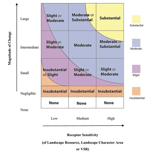
|
|
|
|
|
|
|
|
|
|
|
Note:
The colours in the above
table categorise the total spectrum of impacts rising from the lowest value
at the bottom left corner to the highest value at the top right corner. It
may be seen that for some combination of classification levels of Magnitude
of Change and Receptor Sensitivity, there are 2 possible impact significance
thresholds. When the Magnitude of Change and Receptor Sensitivity are
assessed to be towards the higher ends of each classification level the
resultant impact significance would be deemed to be the higher of the two
impact significance thresholds.
|
(vii)
Prediction of Acceptability
of Impacts. An overall assessment of the
acceptability, or otherwise, of the impacts according to the five levels of
significance set out in Annex 10 of the EIAO-TM is stated in the conclusion in
Section (iv). According to Annex 10, the evaluation of
landscape and visual impacts may be classified into five levels of significance
based on type and extent of the effects concluded in the EIA study:
·
The
impact is beneficial if the
project will complement the landscape and visual character of its setting, will
follow the relevant planning objectives and will improve overall and visual
quality;
·
The
impact is acceptable if the
assessment indicates that there will be no significant effects on the landscape,
no significant visual effects caused by the appearance of the project, or no
interference with key views;
·
The
impact is acceptable with mitigation
measures if there will be some adverse effects, but these can be
eliminated, reduced or offset to a large extent by specific measures;
·
The
impact is unacceptable if the
adverse effects are considered too excessive and are unable to mitigate
practically;
·
The
impact is undetermined if
significant adverse effects are likely, but the extent to which they may occur
or may be mitigated cannot be determined from the study. Further detailed study
will be required for the specific effects in question.
(i)
Landscape and visual
impacts are assessed separately for the construction and operation phases. The assessment of visual impacts has involved
the following procedures.
(ii)
Identification of the Visual Envelope and Zones of
Visual Influence (ZVI) during the construction and operation phases. The visual envelope is the area from which any part
of the proposed project can be seen and may contain areas, which are fully
visible, partly visible and non-visible from the project. The ZVI is the
portion of the visual envelope that is within 10 km from the proposed project.
Identification of the visual envelope and ZVI is achieved by site visits and
desk-top studies of topographic maps and photographs to determine the
visibility of the project from various locations. Given the effects of distance
and the panoramic qualities of many views, VSRs beyond 10 km from the project
will scarcely notice it (and will find it very difficult to distinguish) in
their wider views. At these distances, the proposed project will not form
a feature of any significance in the VSR’s frame of view and consequently will
not influence the visual experience of the VSR. Hence 10 km is considered
the ultimate limit of the Zone of Visual Influence.
(iii)
Identification of the Visually Sensitive Receivers
(VSRs) within the ZVI at construction and operation phases. These are
the people who would reside within, work within, play within, or travel
through, the ZVI. VSRs at both existing and committed developments will be
considered in this assessment.
(iv)
Assessment of the degree of sensitivity to change
of the VSRs. Factors considered include:
·
The
type of VSRs, classified according to whether the person is at home, at work,
at play, or travelling. Those who view
the impact from their homes are considered to be highly sensitive as the
attractiveness or otherwise of the outlook from their home will have a
substantial effect on their perception of the quality and acceptability of
their home environment and their general quality of life. Those who view the
impact from their workplace are considered to be only moderately sensitive as
the attractiveness or otherwise of the outlook will have a less important,
although still material, effect on their perception of their quality of
life. The degree to which this applies
depends on whether the workplace is industrial, retail or commercial. Those who view the impact while taking part
in an outdoor leisure activity may display varying sensitivity depending on the
type of leisure activity. Those who view the impact while travelling on a public
thoroughfare will also display varying sensitivity depending on the speed of
travel.
·
Other
factors which are considered (as required by EIAO GN 8/2010) include the value
and quality of existing views and views from planned developments, the
availability and amenity of alternative views, the duration or frequency of
view, and the degree of visibility.
(v)
The sensitivity of VSRs is
classified as follows:
|
High:
|
The VSR is highly sensitive to
any change in their viewing experience
|
|
Medium:
|
The VSR is moderately
sensitive to any change in their viewing experience
|
|
Low:
|
The VSR is only slightly
sensitive to any change in their viewing experience
|
(vi)
Identification of the relative numbers of VSRs. This is
expressed in terms of whether there are very few, few, many or very many VSRs
in any one category of VSR.
(vii)
Identification of potential sources of visual
impacts. These are the various
elements of the construction works and operational procedures that would
generate visual impacts.
(viii)
Assessment of the potential magnitude of visual
change. Factors considered include:
|
Duration and Frequency of the impact:
|
Temporary / Permanent: This
refers to the long term presence of the visual change – whether it is
experienced by the VSR for the whole duration of the construction phase or
operation phase, or only part thereof.
Intermittent / Continuous:
This refers to short term frequency of the visual change - is it always
visible (continuous) or only at certain times (intermittent). For example, travelling VSRs may only see
the source intermittently as they travel along their journey, whereas
residential VSRs may have continuous views from their living room.
|
|
Reversibility of the impact:
|
Reversible / Irreversible
|
|
Compatibility of the project with the Visual Backdrop:
|
High / Medium / Low
|
|
Distance of the source of impact from the viewer:
|
Shortest distance measured in
metres (m) between the VSR and the source.
|
|
Degree of visibility of Source(s) of Visual Impact:
|
Full: virtually full
uninterrupted view of the source of impact
Partial: partial view of the
source of impact which is slightly hidden by intervening elements such as
buildings, vegetation etc.
Obscured: partial view of the source of impact which
is largely hidden by intervening elements such as buildings, vegetation etc.
|
|
Scale of the development
|
Small / Medium / Large
|
|
Potential Blockage of Existing Views
|
Full / Partial / Slight /
Negligible: The degree to which the
source of the impact blocks existing open views currently experienced by the
VSR.
|
(ix)
The magnitude of visual
change is classified as follows:
|
Large:
|
The VSRs would suffer a major
change in their viewing experience;
|
|
Intermediate:
|
The VSRs would suffer a
moderate change in their viewing experience;
|
|
Small:
|
The VSRs would suffer a small
change in their viewing experience;
|
|
Negligible:
|
The VSRs would suffer no
discernible change in their viewing experience;
|
|
None
|
The VSRs would suffer
absolutely no change in their viewing experience.
|
(x)
Identification of potential visual mitigation
measures. These may take the form of
adopting alternative designs or revisions to the basic engineering and
architectural design to prevent and/or minimise adverse impacts; remedial
measures such as colour and finishing treatment of building features; and
compensatory measures such as the implementation of landscape design measures
(e.g. tree planting, creation of new open space etc.) to compensate for
unavoidable adverse impacts and to attempt to generate potentially beneficial
long term impacts. A programme for the mitigation measures shall be
provided. The agencies responsible for
the funding, implementation, management and maintenance of the mitigation
measures shall be identified and their approval-in-principle shall be sought.
(xi)
Prediction of the significance of visual impacts
before and after the implementation of the mitigation measures. By synthesising the magnitude of the various
visual changes and the sensitivity of the VSR, and the number of individuals in
the VSR that are affected, it is possible to categorise the degree of significance
of the impacts in a logical, well-reasoned and consistent fashion.
Table 8.1 shows the rationale for dividing the degree of significance into four
thresholds, namely, insubstantial, slight, moderate and substantial, depending
on the combination of a negligible / small / intermediate / large magnitude of
change and a low / medium / high degree of sensitivity of VSRs. Consideration is also given to the relative
numbers of individuals in the VSRs in predicting the final impact significance
- exceptionally low or high numbers of individuals in a VSR may change the
result that might otherwise be concluded from a consideration of the type of
the VSRs alone.
Table 8.1 The significance of the visual impacts is categorised as follows:
|
Substantial:
|
Adverse / beneficial impact
where the proposal would cause significant deterioration or improvement in
existing visual quality perceived by the general population;
|
|
Moderate:
|
Adverse / beneficial impact
where the proposal would cause a noticeable deterioration or improvement in
existing visual quality perceived by the general population;
|
|
Slight:
|
Adverse / beneficial impact
where the proposal would cause a barely perceptible deterioration or
improvement in existing visual quality perceived by the general population;
|
|
Insubstantial:
|
No discernible change in the
existing visual quality perceived by the general population;
|
|
None
|
Absolutely no change in the
existing visual quality perceived by the general population.
|
|
|
|
(xii)
Prediction of Acceptability of Residual Impacts. An overall
assessment of the acceptability or otherwise of the residual impacts 10 to 15
years after implementation of visual mitigation measures, according to the five
criteria set out in Annex 10 of the EIAO TM is provided.
8.4.4
Other Considerations
(i)
In accordance with EIAO
Guidance Note 8/2010 (paragraph 3.7(a)) approved projects should form part of
the baseline conditions. Therefore, the
landscape and visual outcomes (including proposed landscape and visual mitigation
measures) of approved projects currently under construction, should be included
as part of the baseline. Details of
relevant concurrent projects are provided in Section 8.5.2.
(ii)
All mitigation proposals in
the EIA report shall be practical and achievable within the known parameters of
funding, implementation, management and maintenance. The suggested agents for
the funding and implementation (and subsequent management and maintenance, if
applicable) are indicated in the EIA report.
Approvals-in-principle to the implementation, management and maintenance
of the proposed mitigation measures in Tables
8.6 and 8.7 have been sought and
obtained from the appropriate authorities.
8.4.5
Photomontages
(i)
Representative views from
various locations have been selected to illustrate the effectiveness of the proposed
impact mitigation proposals and residual impacts of the development in both the
short and long term. Photomontages illustrating the proposed works and the
recommended mitigation measures are listed in Section 8.7.4. The locations of the selected viewpoints are
indicated on Figure
8.7.2 with the views and photomontages illustrated on Figures 8.12.1 to 8.16. The photomontages illustrate the proposed development under
the following scenarios:
·
Existing
Baseline Conditions;
·
Day
1 of completed works without mitigation measures;
·
Day
1 of the completed works with mitigation measures; and
·
The
completed works with mitigation after 10 years.
The landscape impact study area is 500m from the works boundary
surrounding the existing Wang Tong River Bridge and is illustrated on Figure 8.1. To the north the Study Area includes Silver
Mine Bay Beach, the flat lowland Wang Tong valley and the coastal upland hills which
form part of the Lantau North Country Park Extension. To the east, the Study Area includes the sea
area of Silver Mine Bay. To the south
lies the peripheral residential areas of Mui Wo and to the west lies Chung Hau,
Ling Tsui Tau and the vegetated Butterfly Hill.
In accordance with EIAO Guidance Note 8/2010 (paragraph 3.7(a)) approved
projects to be completed before commencement of this project, should form part
of the baseline conditions. The following
approved projects have been identified within the vicinity of the project
site.
(a) Improvement
Works at Mui Wo: Following public consultation and a feasibility study
to enhance the environment and attractiveness of Mui Wo and explore the
recreational potential of Mui Wo, the Islands District Council endorsed the
implementation of a number of improvement works. CEDD is implementing the works by phases in
the town centre of Mui Wo, particularly from the ferry pier leading to
Silvermine Bay Beach. Phase 1 of the
works started in July 2014 with a target completion date of 2016. The current works do not have a direct
interface with the New Wang Tong River Bridge.
(b) Improvement
Works at Silvermine Bay Beach: The Islands District Council proposes to
undertake improvement works under the Signature Projects Scheme to rejuvenate
Silvermine Bay Beach and achieve synergy with the CEDD project. The proposed works include:
·
Demolition
of the existing beach service buildings;
·
Construction
of new beach buildings and associated beach facilities;
·
Construction
of new barbeque pit area and sitting-out area; and
·
Construction
of a viewing deck near the entrance to the beach.
A plan of the proposed improvement works is provided in Appendix 8B. The works are intended to commence in January
2016 and be completed in 2018 (as per programme stated in Legco Paper, however
the latest programme from the Project Architect is completion on 1 January
2017). The project will adopt a modern design for the beach facilities and
buildings. There is no direct interface
between the proposals and those of the New Wang Tong River Bridge and there
appears to be no conflict in the proposed preliminary design for the New Wang
Tong River Bridge which also adopts a contemporary style. However, any unforeseen interface
requirements can be addressed at the Detail Design Stage of the project.
(c) Contract
No. DC/2012/02 – Upgrading of Mui Wo Sewage Treatment Works and Village
Sewerage at Wang Tong and Yue Kwong Tsuen: these DSD works include the
construction of a section of sewer in the vicinity of the existing Wang Tong
River Bridge. These works are
substantially complete and reinstatement of road, cycle track and footpath
surfaces is anticipated to be completed before commencement of the New Wang
Tong River Bridge construction works.
8.5.3
Review of Current Land Uses
A review of the current land-uses within the study area is provided
below. The existing LRs and LCAs within
the study area have been identified and are described in Sections 8.5.4 and 8.5.5. The sensitivities of the LRs and LCAs have been summarised in Table 8.2 and Table 8.3.
(i)
The study area lies within
Mui Wo Layout Plan No. L/I-MWN/IB and L/I-MWC/1F. The land use planning control of the Ferry
Pier Area, Mui Wo Town Centre and Silver Mine Bay Beach waterfront area etc.
are governed by the above mentioned Layout Plans.
(ii)
The western edge of the
study area falls within the Mui Wo Fringe Outline Zoning Plan (OZP) No. S/I –
MWF/10, an extract of which is shown on Figure 8.2.
(iii)
The objective of the plan
is to specify the broad land use zonings and major transport network so that
any development will be under statutory planning control.
(iv)
The following land use
zonings fall within the western edge of the Study Boundary and the planning
intention is described below:
·
Agriculture (“AGR”): This zoning is intended to retain
and safeguard good quality existing agricultural land/farm/fish ponds for
agricultural purposes and fallow arable land with good potential for
rehabilitation for cultivation and other agricultural purposes.
·
Open Space (“O”): the planning intention of this zone
is to provide outdoor open-air space for active and/or passive recreation uses
serving the needs of local residents as well as the general public.
·
Residential (Group A) “R(A)”: this zone is primarily intended for
medium density residential developments. Commercial uses are always permitted
on the ground floor of a building or in the purpose-designed non-residential
portion of an existing building.
·
Green Belt (“GB”): This zone is intended primarily to define
the limits of urban and sub-urban development areas by natural features and to
protect natural landscape as well as to provide passive recreational outlets
for local population and visitors. There
is a general presumption against development within this zone.
·
Government, Institution or Community
(G/IC”): This zone
is intended primarily for the provision of government, institution or community
facilities serving the needs of the local residents and a wider district. It is also intended to provide land for uses
directly related to or in support of the work of the government organisations
providing social services to meet community needs, and other institutional
establishments.
·
Recreation (“REC”): This zone is intended primarily for
the use of the general public. It
encourages the development of active and/or passive recreation and
tourism/eco-tourism. Uses in support of
the recreational developments may be permitted subject to planning permission.
Designated Country Park
Lantau Country Park lies to the west of Mui Wo and the limit of the Mui
Wo Fringe OZP No. S/I – MWF/10. The
Lantau North (Eastern Extension) Country Park eastern extension encompasses the
vegetated hills to the north and east. The proposed project does not physically
impact either of the Country Park areas.
Bridge Environs
The northern edge of the built-up area of Mui Wo is delineated by the
Wang Tong River and this marks the transition to smaller scale village type
development, flat river valley and beach frontage. The existing Wang Tong River Bridge spans the
Wang Tong River where it meets Silver Mine Bay Beach. The Large Silver Mine Bay Beach Resort Hotel
and a formal tree lined beach promenade lies to the south and village type
development lies to the west with the steep, densely vegetated slopes of
Butterfly Hill behind. To the north, semi natural lowland vegetation (former
agricultural land) lies behind the beach with the village of Wang Tong beyond.
The bridge connects the promenade to the south with Silver Mine Bay Beach to the
north which forms a broad sandy crescent curving to the north east. The back of the beach is defined by a
recently upgraded promenade which is used by unsegregated pedestrians, cyclists
and small village powered vehicles. A
mixture of residential, commercial and municipal buildings lie behind the
promenade including small shops, hotels, life guard and public beach changing
facilities. Silver Mine Bay lies to the east.
Conclusion
The proposed project is for the replacement and upgrading of an existing
community facility, and it is therefore considered that there is no conflict
with the relevant planning and development control framework, as it is
consistent with the planning intention of “Footbridge” as stipulated on Mui Wo
Layout Plan No. L/I-MWN/1B.
(i)
The baseline LRs that fall
within the landscape impact study area during the construction phase and
operation phase, together with their sensitivity to change, are described below
and tabulated in Table 8.2. The locations of the LRs are mapped on Figure No. 8.3. Photo-views illustrating the LRs within the
study area are illustrated on Figure No.
8.4.1 to 8.4.5. For ease of
reference and co-ordination between text, tables and drawings, each LR is given
an identity number. Roads and pavement are not considered as Landscape
Resources and have not been included in the mapping of resources. Figure No. 8.3
attempts to formalize boundaries between distinct areas of Landscape Resources
for the purpose of impact assessment, and should not be construed as reflecting
every variable on the ground.
LR1 –Coastal Waters
(ii)
This landscape resource
consists of the sea area within the enclosed tidal bay of Silver Mine Bay. The
approximate area is 28 ha. Given the uniqueness of the bay marine environment,
the scenic value and the resource’s low tolerance to change, the sensitivity is
assessed as High.
LR2a – Wang Tong River
(iii)
The Wang Tong River flows
though the Study Area from the north west to south east, passing under the
existing Wang Tong Bridge and continuing across Silver Mine Bay Beach to the
sea. The River is shallow and non-navigable, and the lower reaches are
tidal. Although it flows through the
agricultural Wang Tong Valley, the river channel is largely natural and
provides a habitat and breeding ground for avifauna and fish (refer to Ecological
Assessment chapter). The approximate
length within the study area is 700 m.
The northern bank is lined with small trees and shrubs, primarily Hibiscus tiliaceus with smaller numbers
of Ficus subpisocarpa, Litsea glutinosa, Macaranga tanarius
var. tomentosa, Melia azardarach, Pandanus tectorius, Syzygium samaragense and
Wedelia trilobata. Mangrove species (Aegiceras
corniculatum and Acanthus ilicifolius)
are also found in the River. Whilst the
value of the ecological habitats within this resource have been rated as low,
given that natural rivers are under threat and a disappearing resource in Hong
Kong and that this resource is difficult to recreate the sensitivity is
assessed as High.
LR2b – River Silver
(iv)
The River Silver flows from
the west through the town area of Ling Tsui Tau until it meets the sea of
Silver Mine Bay. The river has been
largely channelized with engineered banks to control flooding and the lower
reaches have been widened to create a broad, sheltered navigable mooring area
for fishing and pleasure boats. The approximate length of the River Silver is
800m. Whilst the river is an attractive and well-used resource, given the high
degree of intervention along this channel, the tolerance to further change is
considered high and the sensitivity is assessed as Medium.
LR4 – Upland Streams
(v)
Several upland streams
drain off the natural vegetated slopes in the north of the Study Area and into
the Wang Tong River. They have a
combined approximate length of 850m.
Given their scenic and ecological value and low tolerance to change
their sensitivity is assessed as High.
LR5 – Natural Rocky
Coastline
(vi)
The coast within the study
Area consists largely of engineered stone-clad revetments and natural sandy
shoreline. There is an outcrop of
natural granite at the northern end of Silver Mine Bay Beach which forms an
attractive small headland. The approximate area is 530 sq.m. Given its scenic value and that this is the
only remaining natural rocky coast within the Study Area, the sensitivity is
assessed as High.
LR6 – Silver Mine Bay Beach
(vii)
Silver Mine Bay Beach
stretches from the River Silver in the south all the way to the northern corner
of Silver Mine Bay and is a popular, highly used recreational resource. The sand is clean and fine and an ideal surface
for relaxation and recreation. In addition, it provides a valuable marine
habitat for flora and fauna. Floral
species include Casuarina equisitifolia,
Hibiscus tiliaceus, Ipomoea pes-caprae, Macaranga tanarius var. tormentosa,
Terminalia catappa and Wedelia trilobata. The approximate area within the
Study Boundary is 1.6 ha. Given that this resource is both a valuable ecosystem
has a heavily-used recreational venue and cannot be replaced, the sensitivity
is assessed as High.
LR7– Natural Upland
Vegetation
(viii)
The natural slopes of the
surrounding hills support scrubby woodland vegetation. The area within the Study Boundary is
approximately 30 ha. Species composition
varies greatly and is primarily native with some exotic species and includes Celtis sinensis, Ficus spp., Schefflera
heptaphylla forming the canopy
with Daphniphyllum calycinum, Ilex
asprella and Litsea rotundifolia var. oblongifolia
found in the understory. The rare and
precious plant Aquilaria sinensis was
identified in woodland area by the ecological survey. However overall, given that this resource is
relatively common and widespread and can be regenerated, the sensitivity is
assessed as Medium.
LR8 - Semi-Natural Lowland
Vegetation
(ix)
The Wang Tong River Valley
is an area of abandoned agricultural land and now supports areas of regenerated
marsh (species including Acrostichum
aureum, Cyperus involucratus), grassland/shrubland (Melastoma sanguneum, Mikania micrantha) and woodland habitats (Hibiscus tiliaceus, Microcos nervosa,
Tarenna attenuata). Herb species
include Azolla imbricata, Ludwigia
spp. and Zingiber officinale. The
approximate area is 6.9ha. Given its
relatively disturbed nature and that the ecological assessment of value is
generally low for the habitats within this Landscape Resource, the sensitivity
is assessed as Medium.
LR9 - Urban/Domestic Amenity
Planting
(x)
The urban and village areas
of Mui Wo include approximately 5ha of amenity planting including trees and
shrubs planted by local councils on government land and/or private individuals
in private lots. Tree and shrub species
include typical street and park species including Aglaia odorata var.
microphyllina, Araucaria
heterophlylla, Archontophoenix
alexandrae, Bauhinia blakeana, Dimocarpus longan, Duranta erecta, Dypsis
lutescens, Ficus microcarpa, Hibiscus
tileaceus, Lagerstroemia speciosa, Mangifera indica, Playcladus orientalis,
Rhododendron pulchrum, Rhododendron simsii, Terminalia catappa, Roystonea regia.
Two trees within this area are listed as Old and Valuable Trees on the LCSD OVT
Register: LCSD IS/2 – Casuarina
equisetifolia (in the barbecue pits on the Silvermine Bay Beach promenade);
LCSD IS/3 – Ficus microcarpa (on
Chung Hau Street). Neither of these
trees will be impacted. Whilst this planting contributes directly to the
amenity of the town and village areas, it is generally exotic and non-native
and does not generally consist of rare or precious species (OVTs exempted) and
is replaceable. It is therefore assessed
as having Medium sensitivity.
LR10 - Existing Trees in
Vicinity of Wang Tong River Bridge
(xi)
There are a number of
existing trees in the immediate vicinity of the Wang Tong River Bridge growing
either in the waterfront paved areas or Silver Mine Bay Beach. As they may be potentially impacted, a
detailed tree survey has been undertaken in accordance with DEVB TC(W) 7/2015
(refer Appendix
8A). Surveyed trees total 19 no.
and comprise the following species Casuarina
equisetifolia, Celtis sinensis, Ficus
microcarpa, Hibiscus tiliaceus, Macaranga tanarius, Terminalia catappa. Whilst the trees are neither registered Old
and Valuable Trees nor rare or precious species, the trees are mature and do
contribute to the immediate setting of the bridge and provide a positive visual
backdrop to the back of the beach. Their
health and amenity value is generally Fair to Good and their overall sensitivity
is assessed as Medium.
Table 8.2: Landscape
Resources
|
Ref.
ID.
|
Description
|
Sensitivity to Change (Low, Medium, High)
|
|
LR1
|
Coastal
waters
Baseline:
approx. 28ha
|
High
|
|
LR2a
|
Wang
Tong River
Baseline:
approx.700 m
|
High
|
|
LR2b
|
River
Silver
Baseline:
approx. 800m
|
Medium
|
|
LR4
|
Upland
Streams
Baseline:
approx. 850m
|
High
|
|
LR5
|
Natural
Rocky Coastline
Baseline:
approx. 530 m
|
High
|
|
LR6
|
Silvermine
Bay Beach
Baseline:
approx. 1.6ha
|
High
|
|
LR7
|
Natural
Upland Vegetation
Baseline:
approx. 30 ha
|
Medium
|
|
LR8
|
Semi-Natural
Lowland Vegetation
Baseline::
approx. 6.9ha
|
Medium
|
|
LR9
|
Urban/Domestic
Amenity Tree & Shrub Planting
Baseline:
approx. 5 ha
|
Medium
|
|
LR10
|
Existing
Trees in vicinity of Wang Tong Bridge
Baseline:
19 No.
|
Medium
|
Several LCAs have been identified within the study area with reference
to the ‘Landscape Value Map of Hong Kong’ and refined with reference to
existing conditions. These areas, and their sensitivity to change, are
described below and tabulated in Table
8.3. The locations of the LCAs are indicated on Figure
8.5. Photographic views illustrating the LCAs within the study area are
illustrated on Figure 8.6.
For ease of reference and co-ordination between text, tables and drawings each
LCA is given an identity number. The below listed LCA’s represent the baseline
condition after completion of the approved committed projects.
LCA1 – Coastal Upland and
Hillside Landscape
(i)
This area is characterised
by steeply sloping vegetated slopes comprising a mixture of woodland and scrub.
Its approximate area is 28.9 ha. The
northern portion of this LCA lies outside but on the fringe of the Lantau North
(Extension) Country Park, the western portion covers Butterfly Hill and has no
statutory protection and the southern portion lies in Greenbelt which has a
general presumption against development (refer Section 8.5.3 (iv), 4th
bullet) above. The LCA is a mature,
relatively undisturbed environment where vegetation, primarily native species,
has naturally colonised and therefore has a low tolerance to change. This landscape character is relatively common
on Lantau but in the local context of the urban area of Mui Wo, its
preservation is important as the vegetated hills and slopes form a green
backdrop to Mui Wo and provide a degree of enclosure that enhances the setting
and preserves the rural fringe character of the town. Given its relatively natural condition and
low tolerance of change, the sensitivity is of this LCA is assessed as High.
LCA2- Bay Landscape
(ii)
This LCA comprises part of
the open water of Silver Mine Bay and the bay edge including Silver Mine Bay
Beach. Its approximate area is 29.7 ha.
Bay landscape is common on the south side of Lantau but is under increasing
pressure from development. Its value is
recognised by recent government initiatives to promote leisure and tourism on
South Lantau. The waters and beach
forming this LCA are relatively natural and undisturbed and of high
environmental and scenic quality. The
bay waters are highly frequented by leisure and fishing craft and swimmers and
the beach is a popular public facility.
As its landscape value lies in its intrinsic natural beauty, this LCA
has a low ability to accommodate change.
Given all the factors above, the sensitivity of LCA2 is assessed as High.
LCA3 – Rural Township
Landscape
(iii)
This LCA comprises the
collection of villages and the urban areas that make up Mui Wo and is
approximately 25.4 ha in area. It
occupies the flat land between the wooded knoll in the south of the Study Area
and Butterfly Hill in the west. The LCA
also stretches along the back of Silver Mine Bay Beach and includes a strip of
hotels, small shops, public beach facilities and private residences. The settlement of Mui Wo has developed
relatively slowly and remained at a rural township scale due to the lack of
easy access by road. The scale of the
residential buildings is generally small and restricted to 3 storeys or less
and there are a number of larger municipal and commercial buildings and hotels.
The style and type of development is unremarkable and commonly found
throughout the urban fringes of Hong Kong.
Whilst the overall scene has a certain attractiveness (due largely to
the natural setting), the visual and historic quality of the individual
structures is generally low. This LCA
has a reasonable tolerance to change as it is in a constant cycle of renewal as
evidenced by recent Government improvement works. Given the above, the sensitivity of this LCA
is assessed as Medium.
LCA4 – Settled Valley
Landscape
(iv)
This LCA comprises the flat
floor of the Wang Tong River Valley and includes Wang Tong River, both active
and abandoned agricultural fields, marsh, grassland/shrubland, lowland woodland
areas and village type settlements. Its
approximate area is 10.2 ha. It lies on
the fringes of the Lantau North (Extension) Country Park and Greenbelt areas of
Mui Wo. This LCA has an attractive
outlook due to the overall greenness and small scale of development (primarily
village houses of maximum 3 storeys) which imparts a relaxed, rural
atmosphere. The area has evolved
relatively slowly although the size of Wang Tong village has increased in the
last 10 to 20 years as demand for rural fringe lifestyle has increased. The built character of the village areas is
unremarkable and representative of post war rural village development
throughout Hong Kong. The vegetated
portion of this LCA comprises cultivated and abandoned land supporting a
mixture of native and exotic species.
Overall, the scenic quality of this LCA is high and it contributes to
the general attractiveness of the Mui Wo locality. It is viewed from public footpaths passing through
it and on the surrounding hills. Due to
the mixture of land-uses and on-going piecemeal development this LCA has a
reasonable tolerance to change and the sensitivity is assessed as Medium.
Table
8.3: Landscape Character Areas
|
Ref.
ID.
|
Description
|
Sensitivity to Change (Low, Medium, High)
|
|
LCA1
|
Coastal Upland
and Hillside Landscape
Baseline: 28.9
ha
|
High
|
|
LCA2
|
Bay Landscape
Baseline: 29.7
ha
|
High
|
|
LCA3
|
Rural Township
Baseline: 25.4
ha
|
Medium
|
|
LCA4
|
Settled Valley
Baseline: 10.2
ha
|
Medium
|
(i)
The Key Visual Elements of
the visual study area have been mapped on Figure 8.7.1. Silver Mine Bay is a large seawater bay
enclosed by steeply rising topography to the north and south. The ridge lines of the vegetated hills
provide a dramatic backdrop to the bay.
Silver Mine Bay Beach forms the western edge of the bay. The bay overlooks Hei Ling Chau to the east. The key built-up areas and settlements that
contribute to the visual context include Mui Wo Town Centre to the south of the
project site and the village settlements of Chung Hau, Wang Tong and Tung Wan
Tau to the west, north and north east respectively. The proposed project site is at the back of
Silver Mine Bay Beach on the edge of the urban area of Mui Wo. Key view points within the study area are
identified on Figure 8.7.1. These include:
·
Views from inter-island
ferries and recreational craft within Silver Mine Bay;
·
Views from the Mui Wo
Waterfront from the ferry pier to the River Silver;
·
Views from Silver Mine Bay
Beach;
·
Views from Tung Wan Tau
south across Silver Mine Bay;
·
Elevated views from hiking
trails from Mui Wo to the Trappist Monastery and Discovery Bay south across
Silver Mine Bay.
(ii)
The ZVI for the
Construction and Operation Phases of the project has been mapped based on the
exposure of the proposed development to the surrounding environment and is
illustrated on Figure
8.7.2. In accordance with EIAO
GN 8/2010 the ZVI may contain areas which are fully visible, partly visible,
and non-visible from the project. Areas
of visual shadow may occur within the ZVI due to intervening topography, dense
vegetation and man-made structures.
(iii)
The ZVI during the
Construction and Operation Phases will be the same. The bridge is a low
structure and views of it are predominantly from the east across the
unobstructed expanse of the bay. To the
west, the bridge is largely screened by exiting trees at the back of Silver
Mine Bay Beach and the buildings forming Silver Mine Bay Hotel.
(iv)
To the west the ZVI is
demarcated by the buildings and trees at the back of Silver Mine Bay
Beach. There is a limited view corridor
up the Wang Tong River but access is limited to the south bank of the river
along a road with footpath. There will
be Views from the upper storeys of the Silver Mine Bay Hotel but these are
largely screened out by a large existing tree on the hotel boundary. The north
bank is heavily wooded and unoccupied.
Some dwellings on the rising slopes of Butterfly Hill to the west may
have views down the river corridor to the bridge. Views from the hills to the west are screened
out by the heavily wooded Butterfly Hill, existing trees and the Silver Mine
Bay Hotel along the back of Silver Mine Bay Beach (refer photos of views from
the hills to the west of Silver Mine Bay Beach on Figure
8.8.3 which indicate that the bridge cannot be seen from the west due
to topographic and existing tree screens).
(v)
To the north, the ZVI
follows the residences at Tung Wan Tau and is punctuated by viewpoints from the
elevated footpath leading to the Trappist Monastery and Discovery Bay. Trees on the natural slopes to the north prevent
views from much of the footpath. There
are several isolated residences along the northern coast of Silver Mine Bay
with views to the south west towards the bridge. However, apart from these, viewpoints from
above coast level are largely blocked by dense woodland alongside
footpaths.
(vi)
To the east, the ZVI is
defined by the western coast of Hei Ling Chau.
Staff and inmates at the Addiction Treatment Centre will have distant
views north west towards Silver Mine Bay.
The typhoon shelter breakwater defines the ZVI edge to the south of the
island.
(vii)
To the south of the Wang
Tong River Bridge, the ZVI is defined by the Silver Mine Bay Hotel and the
waterfront from the River Silver to the Mui Wo Ferry Pier.
(i)
Within the ZVI, a number of
key VSRs have been identified. These
VSRs are mapped on Figure
No. 8.7.2 and are listed in Table 8.4.
(ii)
For ease of reference, each
VSR is given an identity number, which is used in the text, tables and
drawings.
Table 8.4: Key
Visually Sensitive Receivers (VSRs)
|
VSR ID.
|
Key VSR
|
Value and Quality of Existing
View (Poor,
Fair , Good)
|
Availability of Alternative
Views (Yes,
No)
|
Number of Individuals (Very Few, Many,
Very Many)
|
Sensitivity to Change (Low, Medium, High)
|
|
|
|
|
|
Construction
|
Operation
|
Construction
|
Operation
|
|
Residential VSRs
|
|
RES-1
|
Residents in Chung Hau
|
Good
|
Yes
|
Few
|
Few
|
High
|
High
|
|
RES -2
|
Residents at Tung Wan Tau
|
Good
|
Yes
|
Few
|
Few
|
High
|
High
|
|
RES-3
|
Inmates at Hei Ling Chau Addiction Treatment Centre
|
Good
|
Yes
|
Few
|
Few
|
Medium
|
Medium
|
|
RES-4
|
Residents along North-East Coast of Silver Mine Bay
|
Good
|
Yes
|
Few
|
Few
|
High
|
High
|
|
Recreational VSRs
|
|
REC-1
|
Users of Silver Mine Bay Beach
|
Good
|
Yes
|
Very Many
|
Very Many
|
High
|
High
|
|
REC-2
|
Hikers on Footpath to Trappist Monastery
|
Good
|
Yes
|
Many
|
Many
|
High
|
High
|
|
REC-3
|
Users of Silver Mine Bay waterfront
|
Good
|
Yes
|
Very Many
|
Very Many
|
High
|
High
|
|
REC-4
|
Guests at Silver Mine Bay Beach Hotel (north Block)
|
Good
|
Yes
|
Few
|
Few
|
Medium
|
Medium
|
|
REC-5
|
Recreational Craft in Silver Mine Bay
|
Good
|
Yes
|
Few
|
Few
|
High
|
High
|
|
REC6
|
Visitors to Seafood Restaurants along Silver Mine Bay
Waterfront
|
Good
|
Yes
|
Many
|
Many
|
Low
|
Low
|
|
Travelling VSRs
|
|
T-1
|
Passengers on Inter-Island Ferries
|
Good
|
Yes
|
Very Many
|
Very Many
|
Low
|
Low
|
|
T-2
|
Drivers/Passengers along Ngan Kwong Wan Road
|
Good
|
Yes
|
Very Many
|
Very Many
|
Medium
|
Medium
|
|
T-3
|
Drivers, Cyclists and Pedestrians along Tung Wan Tau Road
|
Good
|
Yes
|
Very Many
|
Very Many
|
Medium
|
Medium
|
|
Occupational VSRs
|
|
O-1
|
Workers in Seafood Restaurants along Silver Mine Bay
Waterfront
|
Good
|
Yes
|
Few
|
Few
|
Low
|
Low
|
|
O2
|
Fishermen in Silver Mine Bay
|
Good
|
Yes
|
Few
|
Few
|
Low
|
Low
|
|
O3
|
Workers in Commercial Outlets along Silver Mine Bay Beach
|
Good
|
Yes
|
Few
|
Few
|
Low
|
Low
|
|
Note: ‘Duration and
Frequency of Views’ and ‘Degree of
Visibility’ have been taken into account in assessing the magnitude of
change in view experience by the VSRs and cannot be double counted in
determining the sensitivity of the VSR.
|
|
|
|
|
|
|
|
|
|
|
|
(i)
The nature and scope of the
works has been described in Section 8.2.
(ii)
The Proposed Project would
create varying levels of landscape and visual impacts on the surrounding areas
during the Construction Phase. Potential
impacts would result from the following sources:
·
Bridge
and ramp demolitions works and modification of existing waterfronts;
·
Removal
of 5 no. existing trees;
·
Haulage
off-site of excavated materials;
·
Stockpiling
of materials for construction of new bridge;
·
Dust
and construction debris;
·
Construction
of on-site offices and working areas;
·
Construction
night lighting; and
·
Presence
of temporary construction hoardings, plant, platforms, structures, construction
machinery and construction vehicle traffic.
(iii)
The Proposed Project would
create varying levels of landscape and visual impacts on the surrounding areas
during the Operation Phase. Potential
impacts would result from the following sources:
·
Presence
of new twin bridges and associated bicycle parking area;
·
Additional
night lighting of bridge decks.
(i)
The magnitude of change,
before implementation of mitigation measures, on the landscape resources and
landscape character areas that would occur in the Construction Phase is
summarised below and tabulated in Table 8.5. All
impacts are adverse unless otherwise stated.
Landscape Resources
(ii)
LR1- Coastal Waters: the dredging works for the removal of the existing bridge pier during
the construction phase will result in a Small
magnitude of change to the coastal waters during the construction period due to
sediment flowing to the sea.
(iii)
LR2a – Wang Tong River: the dredging
works for the removal of the existing bridge pier during the construction phase
will result in a Small
magnitude of change to the river waters and possibly indirect impacts to
coastal plants lining the river during the construction period.
(iv)
LR2b – River Silver: there will be no impacts on the River Silver during the construction
stage and the magnitude of change is therefore assessed as None.
(v)
LR4 – Upland Streams: there will be no impacts on the upland streams during the construction
stage and the magnitude of change is therefore assessed as None.
(vi)
LR5 - Natural Rocky Coastline: there will be no impacts on the natural rocky
coastline during the construction stage and the magnitude of change is
therefore assessed as None.
(vii)
LR6 - Silver Mine Bay Beach: during the construction stage approximately 950
sq.m of the beach will be occupied by temporary construction hoardings, plant,
platforms, structures, construction machinery and construction vehicle traffic.
The magnitude of change is assessed as Small.
(viii)
LR7 – Natural Upland Vegetation: there will be no impacts on the natural upland
vegetation during the construction stage and the magnitude of change is
therefore assessed as None.
(ix)
LR8 – Semi-natural Lowland Vegetation: there will be no impacts on the semi-natural
lowland vegetation during the construction stage and the magnitude of change is
therefore assessed as None.
(x)
LR9 – Urban Domestic Amenity Planting: there will be no impacts on existing urban
domestic amenity planting and the magnitude of change is therefore assessed as None.
(xi)
LR10 – Existing Trees in Vicinity of Wang Tong
Bridge: A total of 7 no. of the 19
no. existing trees are anticipated to be impacted in order to construct the new
Wang Tong River Bridges. Of these, 2 no. will be transplanted and 5 no. will be
felled. Details of the trees and their locations are provided in the Tree Assessment
Schedule and Tree Survey Plan in Appendix
8A and photographs of the existing trees are provided
on Figures 8.4.3 to 8.4.5.
As 7 out of the 19 surveyed trees are affected, the magnitude of change
is assessed as Intermediate.
Landscape Character Areas
(xii)
LCA1 - Coastal Upland and Hillside Landscape: There will be no impacts to this LCA during the
Construction Stage and the magnitude of change is therefore assessed as None.
(xiii)
LCA2 – Bay Landscape: during the Construction Stage, this LCA will experience temporary
impacts to the beach due to construction hoardings, site offices, plant and
materials. However, as the area affected is very minor (approximately 950 sq.m)
in relation to the total area of the LCA (29.7 ha), the magnitude of change is
assessed as Small.
(xiv)
LCA3 – Rural Township Landscape: during the Construction Stage, this LCA will
experience temporary impacts due to bridge and ramp demolition works,
modification of existing waterfronts, materials, construction hoardings and
traffic. However, as the area affected is very minor (approximately 260 sq.m)
in relation to the total area of the LCA (25.4 ha), the magnitude of change is
assessed as Small.
(xv)
LCA4 – Settled Valley Landscape: there will be no impacts to this LCA during the
Construction Stage and the magnitude of change is therefore assessed as None.
8.6.3
Landscape Change Before
Mitigation in Operation Phase
(i)
The magnitude of change,
before implementation of mitigation measures, on the landscape resources and
landscape character areas that would occur in the operation phase is described
below and tabulated in Table 8.5. All
impacts are adverse unless otherwise stated.
Landscape Resources
(ii)
LR1- Coastal Waters: the temporary dredging works for the removal of the existing bridge
pier will be absent during the operation phase and the resulting magnitude of
change to the coastal waters will be None.
(iii)
LR2a – Wang Tong River: the temporary dredging works for
the removal of the existing bridge pier will be absent during the operation
phase and the resulting magnitude of change to the coastal waters will be None.
(iv)
LR2b – River Silver: there will be no impacts on the River Silver during the operation phase
and the magnitude of change is therefore assessed as None.
(v)
LR4 – Upland Streams: there will be no impacts on the upland streams during the operation
phase and the magnitude of change is therefore assessed as None.
(vi)
LR5 - Natural Rocky Coastline: there will be no impacts on the natural rocky
coastline during the operation phase and the magnitude of change is therefore
assessed as None.
(vii)
LR6 - Silver Mine Bay Beach: during the operation stage approximately 395 sq.m
of the beach will be occupied or overhung by the additional area of the
permanent structures of the new twin bridges. As this area is very small in
relation to that of the beach (1.6 ha) the magnitude of change is assessed as Negligible.
(viii)
LR7 – Natural Upland Vegetation: there will be no impacts on the natural upland
vegetation during the operation phase and the magnitude of change is therefore
assessed as None.
(ix)
LR8 – Semi-natural Lowland Vegetation: there will be no impacts on the semi-natural
lowland vegetation during the operation phase and the magnitude of change is
therefore assessed as None.
(x)
LR9 – Urban Domestic Amenity Planting: there will be no impacts on existing urban
domestic amenity planting during the operation phase and the magnitude of
change is therefore assessed as None.
(xi)
LR10 – Existing Trees in Vicinity of Wang Tong
Bridge: before mitigation, the 7
no. existing trees impacted in order to construct the new Wang Tong River
Bridge will have been felled or transplanted at the operation phase. The
magnitude of change will remain as Intermediate.
Landscape Character Areas
(xii)
LCA1 - Coastal Upland and Hillside Landscape: There will be no impacts to this LCA during the
operation phase and the magnitude of change is therefore assessed as None.
(xiii)
LCA2 – Bay Landscape: during the operation phase, this LCA will experience permanent impacts
to the beach due to the additional area of the new twin bridges. However, as the
area affected is very minor (approximately 300 sq.m) in relation to the total
area of the LCA (29.7 ha), the magnitude of change is assessed as Negligible.
(xiv)
LCA3 – Rural Township Landscape: during the operation phase, this LCA will
experience permanent impacts due to presence of the new bridges, ramps and
modified promenades. However, as the area affected is very minor (approximately
95 sq.m) in relation to the total area of the LCA (25.4 ha), the magnitude of
change is assessed as Negligible.
(xv)
LCA4 – Settled Valley Landscape: there will be no impacts to this LCA during the
operation phase and the magnitude of change is therefore assessed as None.
Table 8.5: Magnitude of Landscape Change during the
Construction and Operation Phases before Mitigation
|
ID No.
|
Landscape Resources/
Landscape Character Areas
|
Source of Impact
|
Description of Impacts
|
Magnitude of Change before
Mitigation
|
|
LR1
|
Coastal
Waters
|
Construction
-
Removal of the existing bridge pier.
|
Construction
- Minimal
amounts of sediment from the dredging works to remove the existing bridge
pier
|
Small
|
|
Operation
-
None
|
Operation
- None
|
None
|
|
LR2a
|
Wang
Tong River
|
Construction
-
Removal of the existing bridge pier.
|
Construction
- Minimal
amounts of sediment from the dredging works to remove the existing bridge
pier
|
Small
|
|
Operation
-
None
|
Operation
- None
|
None
|
|
LR2b
|
River Silver
|
Construction
-
None
|
Construction
- None
|
None
|
|
Operation
-
None
|
Operation
- None
|
None
|
|
LR4
|
Upland Streams
|
Construction
-
None
|
Construction
- None
|
None
|
|
Operation
-
None
|
Operation
- None
|
None
|
|
LR5
|
Natural Rocky Coastline
|
Construction
-
-None
|
Construction
- None
|
None
|
|
Operation
-
-None
|
Operation
-
None
|
None
|
|
LR6
|
Silver Mine Bay Beach
|
Construction
- Bridge
and ramp demolitions works and modification of existing waterfronts;
- Stockpiling
of materials for construction of new bridge;
- Dust and
construction debris;
- Construction
of on-site offices and working areas; and
- Presence
of temporary construction hoardings, plant, platforms, structures,
construction machinery and construction vehicle traffic.
|
Construction
- Temporary
loss of beach areas (approximately 950 sq.m) due to presence of temporary
construction hoardings, plant,
platforms, structures, construction machinery and construction vehicle
traffic.
- Baseline
area: 1.6 ha
|
Small
|
|
Operation
- New twin
bridges
|
Operation
- Additional
footprint of new twin bridges (approximately 300 sq.m)
- Baseline
area: 1.6ha
|
Negligible
|
|
LR7
|
Natural Upland Vegetation
|
Construction
-
None
|
Construction
- None
|
None
|
|
Operation
-
None
|
Operation
- None
|
None
|
|
LR8
|
Semi-natural Lowland Vegetation
|
Construction
-
None
|
Construction
- None
|
None
|
|
Operation
-
None
|
Operation
- None
|
None
|
|
LR9
|
Urban/Domestic Amenity Planting
|
Construction
-
None
|
Construction
- None
|
None
|
|
Operation
-
None
|
Operation
- None
|
None
|
|
LR10
|
Existing Trees in Vicinity of Wang Tong Bridge
|
Construction
- Bridge
and ramp demolitions works and modification of existing waterfronts
|
Construction
- Felling
of 5 no. existing trees
- Transplanting
of 2 no. existing trees
- Baseline
no: 19
|
Intermediate
|
|
Operation
- Footprint
of new twin bridges
|
Operation
-
Absence of 5 no. existing trees
-
Baseline no: 19
|
Intermediate
|
|
LCA1
|
Coastal Upland and Hillside Landscape
|
Construction
- None
|
Construction
-
None
|
None
|
|
Operation
-
None
|
Operation
- None
|
None
|
|
LCA2
|
Bay Landscape
|
Construction
- Bridge
and ramp demolitions works and modification of existing waterfronts;
- Stockpiling
of materials for construction of new bridge;
- Dust and
construction debris;
- Construction
of on-site offices and working areas; and
- Presence
of temporary construction hoardings, plant, platforms, structures,
construction machinery and construction vehicle traffic.
|
Construction
- Temporary
loss of beach area (approximately 950 sq.m)
- Baseline
area: 29.7 ha
|
Small
|
|
Operation
-
New twin bridges
|
Operation
- Footprint
of new twin bridges (approximately 300 sq.m)
- Baseline
area: 29.7 ha
|
Negligible
|
|
LCA3
|
Rural Township
|
Construction
- Bridge
and ramp demolitions works and modification of existing waterfronts;
- Stockpiling
of materials for construction of new bridge;
- Dust and
construction debris;
- Temporary
traffic management;
- Construction
of on-site offices and working areas; and
- Presence
of temporary construction hoardings, plant, platforms, structures,
construction machinery and construction vehicle traffic.
|
Construction
- Temporary
loss of area (approximately 260 sq.m)
- Baseline
area: 25.4 ha
|
Small
|
|
Operation
-
New twin bridges
|
Operation
- Additional
footprint of new twin bridges (approximately 95 sq.m)
- Baseline
area: 25.4ha
|
Negligible
|
|
LCA4
|
Settled Valley Landscape
|
-
None
|
Construction
- None
|
None
|
|
-
None
|
Operation
- None
|
None
|
Review
of Planning Principles and Architectural Design
The application of the following principles in
the planning and design of the new bridge(s) has contributed to a reduction in
the landscape and visual impacts:
(i)
Minimisation of the
contractor’s temporary works area, reduction of height and bulk of construction
buildings and structures, the erection of decorative screens and hoardings, the control of night time lighting, the
minimisation of construction traffic and the construction period.
(ii)
Protection of existing
trees and minimisation of felling or transplanting works.
(iii)
Minimisation of dredging
impacts during bridge pier demolition and construction.
(iv)
Sensitive design of the new
bridge in terms of scale, height and bulk, in particular adopting similar
visual forms to the previous bridge design. The proposed new bridges are very
similar in outlook to the Old Bridge and will not appear significantly
different in scale or form.
(v)
Minimising the bridge
visual “weight” by reducing the deck sections as far as possible within
structural constraints and creating shadow lines.
(vi)
Provision of tapered piers
with surface textures to reduce their visual weight and create a more elegant
outlook.
(vii)
Maintaining visual
transparency of parapet by using metal railings rather than solid parapets.
Railings create a lighter, visually more transparent effect enhancing
visibility and the perception of a lighter bridge structure.
(viii)
Physical and visual
integration of bridge with abutments and adjacent promenades through form,
shape and materials. Streetscape shall be sensitively designed in a manner that
responds to the existing village context, and minimises potential adverse
landscape and visual impacts.
(ix)
Use of bridge lighting to
strengthen bridge composition. The bridge decks can be lit from 2 no. light
columns on either side of the bridge which can be positioned symmetrically at
either end of the bridge to appear as an integrated design feature. Lighting units to be directional (downward
focused) to minimise light spill and glare.
(x)
Careful selection of
colours for bridge deck and abutments to highlight certain bridge elements and
downplay others.
(xi)
Framing of Bridge elevation
and screening of abutments with compensatory tree planting. Tree preservation
and compensatory tree planting will be carried out in accordance with DEVB
TC(W) No. 7/2015 Tree Preservation. This requires a compensatory planting ratio
of a minimum 1:1 by number. A minimum of 6 no. heavy standard trees are
proposed to be planted on the beach on the eastern side of the new Wang Tong
River Bridges. In addition, 2 no.
existing trees will be transplanted to locations nearby locations. Provisional
locations for the compensatory trees are illustrated on the Compensatory
Planting Plan in Appendix
8A and on the Landscape and visual Mitigation Plan, Figure
8.17.
(xii)
The proposed landscape and
visual mitigation measures for potential impacts generated during the
construction and operation phases together with the associated funding,
implementation, management and maintenance agencies are described below in Table 8.6 and Table 8.7 and are illustrated on Figure
8.17.
Table 8.6: Proposed
Construction Phase Landscape and Visual Mitigation Measures
|
ID No.
|
Landscape and Visual Mitigation Measure
|
Landscape
measure
|
Visual
measure
|
Funding
Agency
|
Implementation
Agency
|
|
CM1
|
The
construction area and contractor’s temporary works areas should be minimised
to avoid impacts on adjacent landscape.
|
✓
|
✓
|
HyD
|
Contractor
|
|
CM2
|
Reduction
of construction period to practical minimum.
|
|
✓
|
HyD
|
Contractor
|
|
CM3
|
Construction
traffic (land and sea) including construction plant, construction vessels and
barges should be kept to a practical minimum.
|
|
✓
|
HyD
|
Contractor
|
|
CM4
|
Erection
of decorative mesh screens or construction hoardings around works areas in
visually unobtrusive colours.
|
|
✓
|
HyD
|
Contractor
|
|
CM5
|
Avoidance
of excessive height and bulk of site buildings and structures.
|
|
✓
|
HyD
|
Contractor
|
|
CM6
|
Control of night-time lighting by hooding all lights and
through minimisation of night working periods.
|
|
✓
|
HyD
|
Contractor
|
|
CM7
|
All
existing trees shall be carefully protected before, during construction and
after construction. A Detailed Tree Protection Specification shall be
provided in the Contract Specification. Under this specification, the
Contractor shall be required to submit a detailed working method statement
for the protection of trees prior to undertaking any works adjacent to all
retained trees or trees to be transplanted, including trees in contractor’s
works areas for approval by
the Registered Landscape Architect (RLA). This method statement for tree
protection and transplanting shall make reference to "Guidelines on Tree
Preservation during Construction" and "Guidelines on Tree
Transplanting" published by GLTM of the DEVB. Early preparation of trees
to be transplanted shall be undertaken to increase their likely survival rate
following transplanting.
|
✓
|
|
HyD
|
Contractor
|
|
CM8
|
Minimisation
of Impacts to Wang Tong River through minimised and carefully controlled
dredging for pile/abutment removal/construction works
|
✓
|
|
HyD
|
Contractor
|
Table 8.7: Proposed
Operation Phase Landscape and Visual Mitigation Measures
|
ID
No.
|
Landscape and Visual Mitigation Measure
|
Landscape Measure
|
Visual Measure
|
Funding Agency
|
Implementation Agency
|
Management
Agency
|
Maintenance
Agency
|
|
OM1
|
Sensitive
design of bridge in terms of scale, height and bulk (visual weight).
|
|
✓
|
HyD
|
Design Architect/
Engineer
|
HyD
|
HyD
|
|
OM2
|
Use
of appropriate building materials and colours for bridge to complement
surroundings.
|
|
✓
|
HyD
|
Design
Architect/
Engineer
|
HyD
|
HyD
|
|
OM3
|
Lighting
units to be directional and minimise unnecessary light spill and glare.
|
|
✓
|
HyD
|
Design
Architect/
Engineer
|
HyD
|
HyD
|
|
OM4
|
Integration
of bridge with existing abutments and promenades.
|
|
✓
|
HyD
|
Design
Architect/
Engineer
|
HyD
|
HyD
|
|
OM5
|
Compensatory
tree planting for all felled trees shall be provided to the satisfaction of
relevant Government departments.
Required numbers and locations of compensatory trees shall be
determined and agreed separately with Government during the Tree Felling
Application process under the relevant technical circulars.
|
✓
|
✓
|
HyD
|
Contractor
|
HyD,
until such time the trees are
successfully handed over to LCSD
|
HyD,
until such time the trees are
successfully handed over to LCSD
|
|
OM6
|
Streetscape
(e.g. paving, signage, street furniture, lighting etc.) shall be sensitively
designed in a manner that responds to the existing village context, and
minimises potential adverse landscape and visual impacts.
|
✓
|
✓
|
HyD
|
Design
Architect/
Engineer
|
HyD
|
HyD
|
Programme of Implementation of Landscape and Visual Mitigation Measures
(xiii)
The construction phase
measures listed above shall be adopted from the commencement of construction
and shall be in place throughout the entire construction period. The operation phase measures listed above
shall be adopted during the detailed design, and be built as part of the
construction works so that they are in place at the date of commissioning of
the Proposed Project. However, it should
be noted that the full effect of the soft landscape mitigation measures would
not be appreciated for several years.
(i)
The potential significance
of the landscape impacts during the construction and operation phases, before
and after mitigation, are provided below in Table 8.8 and the residual impact significance after 10
years is mapped on Figure
8.9 and 8.10.
This assessment follows the methodology outlined in Section 8.4 above and assumes that the appropriate mitigation
measures identified in Table 8.6 and
Table 8.7 above will be implemented, and that the full effect of the soft
landscape mitigation measures will be realised after 10 years. Photomontages of the proposed works before
and after mitigation are provided in Figures
8.12.1 to 8.16 inclusive.
Construction Phase before Mitigation
(ii)
During the construction
phase, before the implementation of the proposed mitigation measures, there
will be some adverse landscape impacts as summarised below and identified in Table 8.8.
Landscape Resources
(iii)
LR1, (Coastal Waters) would experience impacts of Slight
significance before mitigation due to the dredging works associated with the
removal of the existing bridge pier.
(iv)
LR2a, (Wang Tong River) would experience an impact significance of Slight before mitigation due to the dredging works associated with
the removal of the existing bridge pier.
(v)
LR2b, (River Silver) would experience an impact significance of None due to the absence of any impacts.
(vi)
LR4, (Upland Streams) would experience an impact significance of None due to the absence of any impacts.
(vii)
LR5, (Natural Rocky Coastline) would experience an impact significance of None due to the absence of any impacts.
(viii)
LR6, Silver Mine Bay Beach) would experience an impact significance of Slight
due to temporary loss of 950
sq.m. (out of a total area of 1.6ha) due to bridge construction activities,
plant and materials.
(ix)
LR7, (Natural Upland Vegetation) would experience an impact significance of None due to the absence of any impacts.
(x)
LR8, (Semi-natural Lowland Vegetation) would experience an impact significance of None due to the absence of any impacts.
(xi)
LR9, (Urban/Domestic Amenity Planting) would experience an impact significance of None due to the absence of any impacts.
(xii)
LR10, (Existing Trees in the Vicinity of Wang Tong
River Bridge) would experience an impact
significance of Moderate due to the
loss of 7 no. existing trees out of a total of 19 trees.
Landscape Character Areas
(xiii)
LCA1 (Coastal Upland and Hillside Landscape) would experience an impact significance of None due to the absence of any impacts.
(xiv)
LCA2 (Bay Landscape) would experience an impact significance of Slight due to the loss of approximately 950 sq.m of beach area (out
of a total area of 29.7 ha) due to temporary bridge construction activities,
plant and materials.
(xv)
LCA3 (Rural Township Landscape) would experience an impact significance of Slight due to the temporary loss of
approximately 260 sq.m. of seafront promenade (out of a total area of 25.4 ha)
due to bridge construction activities..
(xvi)
LCA4 (Settled Valley Landscape) would experience an impact significance of None due to the absence of any impacts.
Construction Phase After Mitigation
During
the construction phase after mitigation, the landscape impacts would be as
follows:
Landscape Resources
(xvii)
LR1, (Coastal Waters) and LR2a, (Wang Tong River) would experience a reduction in temporary
landscape from Slight (before
mitigation) to Insubstantial after
mitigation. The degree of siltation caused by the dredging works is impossible
to quantify but working practices to reduce siltation such as the use of silk
curtains can significantly reduce the potential impacts.
(xviii)
LR6, (Silver Mine Bay Beach) and LR10, (Existing
Trees in the Vicinity of Wang Tong River Bridge) would continue to experience an impact significance of Slight and Moderate respectively as mitigation measures would not be
sufficient to reduce the impact significance threshold.
(xix)
All other Landscape Resources
(LR1 to LR5, LR7 to LR9) would
continue to experience an impact significance of None following the implementation of mitigation measures due to an
absence of impacts.
Landscape Character Areas
(xx)
LCA2 (Bay Landscape) and LCA3 (Rural Township
Landscape) would continue to experience temporary landscape impacts of Insubstantial significance as the
mitigation measures would not be sufficient to reduce the impact significance
threshold.
(xxi)
LCA1, (Coastal Upland and Hillside Landscape) and LCA4
(Settled Valley Landscape) would continue to experience an impact
significance of None following the implementation of mitigation measures due to
an absence of impacts.
Operation Phase before Mitigation
(xxii)
In the operation phase, before
the implementation of the proposed mitigation measures, there would be some
adverse landscape impacts as summarised below and identified in Table 8.8.
Landscape Resources
(xxiii)
LR1 (Coastal Waters) would experience an impact significance of None due to the absence of any impact.
(xxiv)
LR2a (Wang Tong River) would experience an impact significance of None due to the absence of any impact.
(xxv)
LR2b (River Silver) would experience an impact significance of None due to the absence of any impacts.
(xxvi)
LR4 (Upland Streams) would experience an impact significance of None due to the absence of any impact
(xxvii)
LR5, (Natural Rocky Coastline) would experience an impact significance of None due to the absence of any impact.
(xxviii) LR6, (Silver Mine Bay
Beach) would experience an impact
significance of Insubstantial due to
the permanent presence of the new bridge (approximately 300 sq.m. out of a
total area of 1.6ha).
(xxix)
LR7, (Natural Upland Vegetation) would experience an inpact significance of None due to the absence of any impact.
(xxx)
LR8, (Semi- natural Lowland Vegetation would experience an impact significance of None due to the absence of any impact.
(xxxi)
LR9, (Urban/Domestic Amenity Planting) would experience an impact significance of None due to the absence of any impacts.
(xxxii)
LR10 (Trees in the vicinity of Wang Tong River
Bridge) would continue to
experience an impact significance of Moderate
before mitigation in the operation phase due to the remaining loss of 5 no.
existing trees.
Landscape Character Areas
(xxxiii) LCA1 (Coastal Upland and
Hillside Landscape) would experience an impact
significance of None due to the
absence of any impacts.
(xxxiv) LCA2 (Bay Landscape) would experience and impact significance of Insubstantial during the operation
stage before mitigation due to minor loss of beach area due to the permanent
footprint of the new bridge (approximately 300 sq.m. out of a total beach LCA
area of 29.7ha).
(xxxv)
LCA3 (Rural Township Landscape) would experience and impact significance of Insubstantial during the operation
stage before mitigation due to the permanent footprint of the new bridge and
promenade ramps (approximately 95 sq.m. out of a total LCA area of 25.4ha).
(xxxvi) LCA4 (Settled Valley
Landscape) would experience an impact
significance of None due to an
absence of any impacts.
Operation Phase after Mitigation
(xxxvii) In the operation phase, after the implementation of
the proposed mitigation measures, there will be some adverse residual landscape
impacts as summarised below and identified in Table 8.8.
(xxxviii) Implementation of the recommended mitigation
measures will reduce the magnitude of the residual landscape impacts during the
operation phase, although this does not generally reduce the overall
significance thresholds described above for the before mitigation scenario.
Landscape Resources
(xxxix) For LR6
(Silver Mine Bay Beach) the impact
significance would remain as Insubstantial
at Day 1 and Year 10 as mitigation measures would not materially reduce the
area of beach affected by the new bridge.
(xl)
For LR10, (Existing Trees in the Vicinity of Wang Tong River Bridge)
the impact significance would be reduced from Moderate to Slight at Day 1 due to the transplanting of 2 no. existing trees
and the planting of 6 no. compensatory trees on the beach on the eastern side
of the bridge. This would be further
reduced to Insubstantial at Year 10 once the compensatory planting has matured.
(xli)
For all the remaining LRs,
(LR1 to LR5 and LR7 to LR9) the impact significance will
remain as None during the operation
stage after mitigation due to the absence of any impacts.
Landscape Character Areas
(xlii)
For LCA2, (Bay Landscape) and LCA3
(Rural Township Landscape) the impact significance during the operation
phase after mitigation would remain as Insubstantial
at Day1 and Year 10.
(xliii)
For LCA1, (Coastal Upland and Hillside Landscape) and LCA4 (Settled Valley Landscape) the
impact significance during the operation phase after mitigation would remain as
None due to the absence of any
impacts.
Table 8.8:
Significance of Landscape Impacts in Construction and Operation Phases
(Adverse Impacts unless otherwise stated)
|
Id.
No.
|
Landscape
Resource /
Landscape
Character
|
Sensitivity
to Change during Construction and Operation Phases (Low,
Medium, High)
|
Magnitude
of Change before Mitigation (None, Negligible, Small, Intermediate, Large)
|
Impact
Significance Threshold BEFORE Mitigation
(None, Insubstantial, Slight, Moderate,
Substantial)
|
Recommended
Mitigation Measures
|
Residual
Impact Significance Threshold AFTER Mitigation
(None, Insubstantial, Slight, Moderate,
Substantial)
|
|
Construction
|
Operation
|
|
Construction
|
Operation
|
Construction
|
Operation
|
DAY
1
|
YEAR
10
|
|
Landscape Resources
|
|
LR1
|
Coastal
Waters
|
High
|
Small
|
None
|
Slight
|
None
|
CM1,8
|
Insubstantial
|
None
|
None
|
|
LR2a
|
Wang
Tong River
|
High
|
Small
|
None
|
Slight
|
None
|
CM1,8
|
Insubstantial
|
None
|
None
|
|
LR2b
|
River
Silver
|
Medium
|
None
|
None
|
None
|
None
|
N/A
|
None
|
None
|
None
|
|
LR4
|
Upland
Streams
|
High
|
None
|
None
|
None
|
None
|
N/A
|
None
|
None
|
None
|
|
LR5
|
Natural
Rocky Coastline
|
High
|
None
|
None
|
None
|
None
|
N/A
|
None
|
None
|
None
|
|
LR6
|
Silver
Mine Bay Beach
|
High
|
Small
|
Negligible
|
Slight
|
Insubstantial
|
CM1,7
OM5
|
Slight
|
Insubstantial
|
Insubstantial
|
|
LR7
|
Natural
Upland Vegetation
|
Medium
|
None
|
None
|
None
|
None
|
N/A
|
None
|
None
|
None
|
|
LR8
|
Semi-natural
Lowland Vegetation
|
Medium
|
None
|
None
|
None
|
None
|
N/A
|
None
|
None
|
None
|
|
LR9
|
Urban/Domestic
Amenity Planting
|
Medium
|
None
|
None
|
None
|
None
|
N/A
|
None
|
None
|
None
|
|
LR10
|
Existing
Trees in vicinity of Wang Tong River Bridge
|
Medium
|
Intermediate
|
Intermediate
|
Moderate
|
Moderate
|
CM1, 7
OM5
|
Moderate
|
Slight
|
Insubstantial
|
|
Landscape Character Areas
|
|
LCA1
|
Coastal
Upland and Hillside Landscape
|
High
|
None
|
None
|
None
|
None
|
N/A
|
None
|
None
|
None
|
|
LCA2
|
Bay
Landscape
|
High
|
Small
|
Negligible
|
Slight
|
Insubstantial
|
CM1,7,8
OM5
|
Insubstantial
|
Insubstantial
|
Insubstantial
|
|
LCA3
|
Rural
Township Landscape
|
Medium
|
Small
|
Negligible
|
Slight
|
Insubstantial
|
CM1,7,8
OM6
|
Insubstantial
|
Insubstantial
|
Insubstantial
|
|
LCA4
|
Settled
Valley Landscape
|
Medium
|
None
|
None
|
None
|
None
|
N/A
|
None
|
None
|
None
|
|
|
|
|
|
|
|
|
|
|
|
|
|
|
|
|
The
sources of visual impacts of the project during construction and operation
phases have been described in Section 8.6.1.
The
magnitude of visual change resulting from the construction and operation phases
of the Proposed Project is presented in Table 8.9.
The proposed visual mitigation measures for impacts from the
construction and operation phases are described previously in Table 8.6 and Table 8.7, together with the associated funding, implementation,
management and maintenance agencies and the proposed implementation programme.
Please refer to Figure
8.17 for the Landscape and Visual Mitigation Measures plan.
(i)
The photomontage viewpoints
were selected as representative examples of the visual impacts of the project.
Viewpoints have been selected to provide close, medium and long range views of
the project. The locations of the viewpoints are indicated on Figure
8.7.2. The photomontages showing the proposed development at ‘Existing
Baseline Conditions’ on ‘Day 1 of completed works without mitigation measures’,
‘Day 1 of the completed works with mitigation measures’ and ‘Year 10 of the
completed works with mitigation measures’ are illustrated on Figures 8.12.1 to 8.16.
·
P1 - View East from Chung Hau
(RES-1): this
viewpoint was selected as representative of views from residents at Chung Hau
(RES-1) as it provides direct views of the bridge from the west. The viewpoint is on the footpath north of the
Silver Mine Bay Beach Hotel at an elevation of approximately 4.10 mPD.
·
P2 – View West from Silver Mine Bay
Beach (REC-1): this viewpoint was selected as representative
of views from users of Silver Mine Bay Beach, (VSR REC-1) as it provides direct
low level views towards the bridge from the east. The viewpoint is located at
an elevation of approximately 1.00 mPD.
·
P3 – View North West from Silver
Mine Bay Waterfront (REC-3): this viewpoint was selected as
representative of views from diners at the seafood restaurants along the Silver
Mine Bay Waterfront (REC-3) as it provides direct low level views across the
bay towards the bridge. The viewpoint is located at an elevation of
approximately 4.00 mPD.
·
P4 – View North West from Silver
Mine Bay (REC-5; T1; O3): this viewpoint was selected as representative of views from recreational
craft (REC-5), passengers on
inter-island ferries (T-1) and fishermen in Silver Mine Bay and it provides low
level direct views north west across Silver Mine Bay towards the bridge. The
viewpoint is at an elevation of approximately 2.00 mPD
·
P5 – View South West from Tung Wan
Tau (RES-2; T3): this
viewpoint was selected as representative of views from residents at Tung Wan
Tau (RES-2) and drivers, cyclists and pedestrians using Tung Wan Tau Road and
has low level views south west across the bay towards the bridge. The viewpoint is at an elevation of
approximately 3.00 mPD.
Table 8.9: Magnitude
of Visual Change during the Construction and Operation Phases before Mitigation
|
VSR ID
|
Key VSR
|
Compatibility of the Project
with the Visual Backdrop
(High/Medium/Low)
|
Duration and Frequency of
Impacts
(Temporary/Permanent
& Intermittent/Continuous)
|
Scale
of Development (Large/Medium/Small) & Reversibility of Change
(Yes/No)
|
Degree of Visibility of
Source(s) of Visual Impact (Full, Partial, Obscured) &
Distance Between VSR &
Nearest Source(s) of Impact
|
Potential Blockage of
Existing View (Full/Partial/Slight/Negligible)
|
Magnitude of Visual Change
BEFORE Mitigation
(Large,
Intermediate, Small, Negligible, None)
|
|
Construction
|
Operation
|
Construction
|
Operation
|
Construction
|
Operation
|
Construction
|
Operation
|
|
Residential VSRs
|
|
RES-1
|
Residents in Chung Hau
|
Medium
|
Permanent, Continuous
|
Permanent,
Continuous
|
Small, No
|
Partial, 200m
|
Partial, 200m
|
Negligible
|
Negligible
|
Intermediate
|
Intermediate
|
|
RES-2
|
Residents in Tung Wan Tau
|
Medium
|
Permanent, Continuous
|
Permanent,
Continuous
|
Small, No
|
Full, 900m
|
Full, 900m
|
Negligible
|
Negligible
|
Negligible
|
Negligible
|
|
RES-3
|
Inmates at Hei Ling Chau Addiction Treatment Centre
|
Medium
|
Permanent, Continuous
|
Permanent,
Continuous
|
Small, No
|
Full, 4,200m
|
Partial, 4,200m
|
Negligible
|
Negligible
|
Negligible
|
Negligible
|
|
RES-4
|
Residents along north east coast of Silver Mine Bay
|
Medium
|
Permanent, Continuous
|
Permanent,
Continuous
|
Small, No
|
Full, 1000m
|
Full, 1000m
|
Negligible
|
Negligible
|
Negligible
|
Negligible
|
|
Recreational VSRs
|
|
REC-1
|
Users of Silver Mine Bay Beach
|
Medium
|
Temporary,
Intermittent
|
Temporary,
Intermittent
|
Small, No
|
Full, 0m
|
Full, 0m
|
Negligible
|
Negligible
|
Large
|
Small
|
|
REC-2
|
Hikers on Footpath to Trappist Monastery
|
Medium
|
Temporary,
Intermittent
|
Temporary,
Intermittent
|
Small, No
|
Full, 1,200m
|
Full, 1,200m
|
Negligible
|
Negligible
|
Small
|
Small
|
|
REC-3
|
Users of Silver Mine Bay Waterfront
|
Medium
|
Temporary,
Intermittent
|
Temporary,
Intermittent
|
Small, No
|
Partial , 400m
|
Partial , 400m
|
Negligible
|
Negligible
|
Small
|
Small
|
|
REC-4
|
Guests at Silver Mine Beach Resort Hotel (north Block)
|
Medium
|
Temporary,
Intermittent
|
Temporary,
Intermittent
|
Small, No
|
Full , 30m
|
Full , 30m
|
Negligible
|
Negligible
|
Large
|
Intermediate
|
|
REC-5
|
Recreational Craft in Silver Mine Bay
|
Medium
|
Temporary,
Intermittent
|
Temporary,
Intermittent
|
Small, No
|
Full , 100m
|
Full , 100m
|
Negligible
|
Negligible
|
Small
|
Small
|
|
REC-6
|
Visitors to Seafood Restaurants along Silver Mine Bay
Waterfront
|
Medium
|
Temporary,
Intermittent
|
Temporary,
Intermittent
|
Small, No
|
Partial, 400m
|
Partial, 400m
|
Negligible
|
Negligible
|
Small
|
Small
|
|
Travelling VSRs
|
|
T-1
|
Passengers on Inter-Island Ferries
|
Medium
|
Temporary,
Intermittent
|
Temporary,
Intermittent
|
Small, No
|
Full, 600m
|
Full, 600m
|
Negligible
|
Negligible
|
Negligible
|
Negligible
|
|
T-2
|
Drivers & Passengers along Ngan Kwong Wan Road
|
Medium
|
Temporary,
Intermittent
|
Temporary,
Intermittent
|
Small, No
|
Partial, 300m
|
Partial, 300m
|
Negligible
|
Negligible
|
Small
|
Small
|
|
T-3
|
Drivers, Cyclists & Pedestrians along Tung Wan Tau
Road
|
Medium
|
Temporary,
Intermittent
|
Temporary,
Intermittent
|
Small, No
|
Full, 0m
|
Full, 0m
|
Negligible
|
Negligible
|
Large
|
Intermediate
|
|
Occupational VSRs
|
|
O-1
|
Workers in Seafood Restaurants along Silver Mine Bay
Waterfront
|
Medium
|
Temporary,
Intermittent
|
Temporary,
Intermittent
|
Small, No
|
Partial, 400m
|
Partial, 400m
|
Negligible
|
Negligible
|
Small
|
Small
|
|
O-2
|
Fishermen in Silver Mine Bay
|
Medium
|
Temporary,
Intermittent
|
Temporary,
Intermittent
|
Small, No
|
Full, 400m
|
Full, 400m
|
Negligible
|
Negligible
|
Small
|
Small
|
|
O3
|
Workers in Commercial Outlets along Silver Mine Bay Beach
|
Medium
|
Temporary,
Intermittent
|
Temporary,
Intermittent
|
Small, No
|
Full, 10m
|
Full, 10m
|
Negligible
|
Negligible
|
Large
|
Large
|
|
Note:
|
|
|
|
|
|
|
|
|
|
|
|
|
(1) The closet viewing distance has been used to rate the
worst case scenario
(2) ‘Permanent’
duration measurement refers to entire construction/operation phase
|
An assessment
of the significance of the potential visual impacts during the construction and
operation phases, before and after mitigation, is briefly described, and listed
in detail in Table 8.10 (All impacts are adverse unless otherwise stated). This follows the
methodology outlined in Section 8.4 above and assumes that the appropriate mitigation measures identified
in Table 8.6 and Table 8.7 would be implemented, and
that the full effect of the soft landscape mitigation measures would be
realised after 10 years.
(i)
Due to the small scale and
low profile of the bridge, the magnitude of visual change to the VSRs will only
be perceived as ‘Large’ before mitigation by VSRs which are very close to the
development. All other VSRs will
perceive the magnitude of change as ‘Small’ or ‘Negligible’ before mitigation
measures. Many of the VSRs are a long distance away and enjoy good quality
panoramic views of the sea, beach, mountains and offshore islands and
alternative views are available. The impact upon each VSR is described in
greater detail below. The magnitude of
impacts experienced by VSRs is generally greater in the construction phase than
in the operation phase for most VSRs due to the presence of the construction activities
and temporary disturbance to the landscape.
(ii)
Photomontages illustrating
the existing views and operation phase impacts before and after (Day 1 and Year
10) the implementation of mitigation measures are provided in Figures 8.12.1 to 8.16 and their locations
are illustrated on Figure
8.7.2. Mitigation measures are described in more detail in Table 8.6 and Table 8.7.
Residential VSRs
(iii)
Residents in Chung Hau (RES-1) will have permanent and continuous full views east
towards the new bridge. During the construction phase, the magnitude of visual
change will be ‘Intermediate’, and this combined with their ‘High’ sensitivity
will result in a visual impact of Moderate
significance both before and after mitigation (whilst the proposed construction
phase mitigation measures will help reduce the visual impacts, the effects will
not be enough to reduce the impact threshold).
During the operation phase following the removal of sources of temporary
construction impacts and the implementation of visual mitigation measures, the
predicted visual impact significance is predicted to be reduced to Slight at Day 1 and at Year 10. The impact significance will not reduce over
time as the proposed mitigation tree planting lies on the east side of the
bridge and will not therefore provide any additional screening benefits for the
Chung Hau residents as it matures.
(iv)
Residents at Tung Wan Tau (RES-2), Inmates at Hei
Ling Chau Addiction Treatment Centre (RES-3), Residents along north east coast
of Silver Mine Bay (RES-4) will all experience a
negligible magnitude of change due to their distance of view and this will
result in Insubstantial visual impacts during construction and operation, both
before and after the implementation of mitigation measures. Proposed tree mitigation planting will
enhance screening of the new bridges from Day 1 to Year 10 as it matures.
Recreational VSRs
(v)
Users of Silver Mine Bay Beach (REC-1) will have full views east towards the new bridge.
During the construction phase, the magnitude of visual change will be ‘Large’,
and this combined with their ‘High’ sensitivity will result in a visual impact
of Substantial significance both
before and after mitigation (whilst the proposed construction phase mitigation
measures will help reduce the visual impacts, the effects will not be enough to
reduce the impact threshold due to the scale of the works and the proximity of
the VSRs who will still experience significant visual impacts). During the operation phase following the
removal of sources of temporary construction impacts the predicted visual
impact significance before mitigation is Moderate.
After the implementation of visual mitigation measures, the predicted visual
impact significance will be Moderate
at Day 1 due to the provision of a visually integrated bridge design which is
not significantly greater in scale or form than the existing bridge. Due to the
low level view of beach users, the cycle bridge will largely screen out the
pedestrian bridge behind, thus the twin bridges will be perceived as a single
bridge of similar elevation to the old bridge. At Year 10 the visual impact
significance will be further reduced to Slight
due to the maturing of mitigation tree planting which will enhance visual
framing and screening of the new bridges.
(vi)
Guests at Silver Mine Beach Resort Hotel (REC-4) in upper rooms in the northern block overlooking
the Wang Tong River will have elevated full views north-east towards the new
bridge. During the construction phase, the magnitude of visual change will be
‘Large’, and this combined with their ‘Medium’ sensitivity will result in a
visual impact of Substantial significance
before and after mitigation. During the operation phase following the removal
of sources of temporary construction impacts and the implementation of visual
mitigation measures, the predicted visual impact significance will be reduced
to Moderate at Day 1 due to the
provision of a visually integrated bridge design. Due to their elevated
viewpoint, guests will perceive both bridges (which will represent a relatively
larger visual impact than the low level views experienced by beach users). At
Year 10 the visual impact significance will not be reduced by the effects of
maturing mitigation tree planting which lies on the eastern side of the bridge
and therefore the visual impact significance will remain as Moderate.
(vii)
Users of Silver Mine Bay Waterfront (REC-3) between the seafood restaurants and the River
Silver will have partial views north west towards the new bridge. During the
construction phase, the magnitude of visual change will be ‘Small’ due to the
distance of view (400m) and partial screening by existing trees, and this
combined with their ‘High’ sensitivity will result in a visual impact of Moderate significance both before and
after mitigation (whilst the proposed construction phase mitigation measures
will help reduce the visual impacts, the effects will not be enough to reduce
the impact threshold). During the
operation phase following the removal of sources of temporary construction
impacts and the implementation of visual mitigation measures, the predicted
visual impact significance will be reduced to Slight at Day 1 due to the provision of a visually integrated
bridge design which is not significantly greater in scale or form than the
existing bridge and compensatory tree planting.
At Year 10 the visual impact significance will be further reduced to Insubstantial due to the maturing of
mitigation tree planting which will enhance visual framing and screening of the
new bridges.
(viii)
Hikers on Footpath to Trappist Monastery (REC-2) will have full elevated views south west towards
the new bridge. During the construction phase, the magnitude of visual change
will be ‘Small’ due to the distance of view (minimum 1200m), and this combined
with their ‘High’ sensitivity will result in a visual impact of Slight significance both before and
after mitigation (whilst the proposed construction phase mitigation measures
will help reduce the visual impacts, the effects will not be enough to reduce
the impact threshold). During the
operation phase following the removal of sources of temporary construction impacts
and the implementation of visual mitigation measures, the predicted visual
impact significance will be Insubstantial
at Day 1 due to the provision of a visually integrated bridge design which is
not significantly greater in scale or form than the existing bridge and
compensatory tree planting. At Year 10
the visual impact significance will remain as Insubstantial and the maturing of mitigation tree planting will
further enhance the visual framing and screening of the new bridges.
(ix)
Recreational Craft in Silver Mine Bay (REC-5) will have full views north towards the new bridge.
During the construction phase, the magnitude of visual change will be ‘Small’
due to the distance of view (minimum 100m) and partial screening by existing
trees, and this combined with their ‘High’ sensitivity will result in a visual
impact of Slight significance both
before and after mitigation (whilst the proposed construction phase mitigation
measures will help reduce the visual impacts, the effects will not be enough to
reduce the impact threshold). During the
operation phase following the removal of sources of temporary construction
impacts and the implementation of visual mitigation measures, the predicted
visual impact significance will be Slight
at Day 1 due to the provision of a visually integrated bridge design which
is not significantly greater in scale or form than the existing bridge and
compensatory tree planting. At Year 10
the visual impact significance will be further reduced to Insubstantial due to the maturing of mitigation tree planting which
will enhance visual framing and screening of the new bridges.
(x)
Visitors to Seafood Restaurants along Silver Mine
Bay Waterfront (REC-6) between the ferry pier and
the waterfront will have partial views north west towards the new bridge.
During the construction phase, the magnitude of visual change will be ‘Small’
due to the distance of view (minimum 400m) and partial screening by existing
trees, and this combined with their ‘Low’ sensitivity will result in a visual
impact of Slight significance both before
and after mitigation (whilst the proposed construction phase mitigation
measures will help reduce the visual impacts, the effects will not be enough to
reduce the impact threshold). During the
operation phase following the removal of sources of temporary construction
impacts and the implementation of visual mitigation measures, the predicted
visual impact significance will be Slight
at Day 1 due to the provision of a visually integrated bridge design which is
not significantly greater in scale or form than the existing bridge and
compensatory tree planting. At Year 10
the visual impact significance will be further reduced to Insubstantial due to the maturing of mitigation tree planting which
will enhance visual framing and screening of the new bridges.
Travelling VSRs
(xi)
Drivers, Cyclists and Pedestrians along Tung Wan
Tau Road (T3) will have full views of
the new bridge as they approach and are diverted around it temporarily during
the construction phase or cross it during the operational phase. During the
construction phase, the magnitude of visual change will be ‘Large’, and this
combined with their ‘Medium’ sensitivity will result in a visual impact of Substantial significance both before and
after mitigation (whilst the proposed construction phase mitigation measures
will help reduce the visual impacts, the effects will not be enough to reduce
the impact threshold). During the
operation phase the magnitude of visual change will be reduced to Intermediate
and combined with a Medium sensitivity to Change this will give a visual impact
significance before mitigation of Moderate
due to the increased visual impact of the twin bridges compared to the original
single bridge. Following the implementation of visual mitigation measures, the
predicted visual impact significance will be Moderate at Day 1 due to the provision of a visually integrated
bridge design which is not significantly greater in scale or form than the
existing bridge and compensatory tree planting.
At Year 10 the visual impact significance will not be reduced for this
VSR by the effect of maturing mitigation tree planting on the eastern side of
the new bridges and therefore the residual visual impact will remain as Moderate.
(xii)
Drivers and Passengers along Ngan Kwong Wan Road
(T-2) between the seafood
restaurants and the River Silver will have partial views north west towards the
new bridges. During the construction phase, the magnitude of visual change will
be ‘Small’ due to the distance of view (400m) and partial screening by existing
trees, and this combined with their ‘Medium’ sensitivity will result in a
visual impact of Slight significance
both before and after mitigation (whilst the proposed construction phase
mitigation measures will help reduce the visual impacts, the effects will not
be enough to reduce the impact threshold).
During the operation phase following the removal of sources of temporary
construction impacts and the implementation of visual mitigation measures, the
predicted visual impact significance will be Slight at Day 1 due to the provision a visually integrated bridge
design which is not significantly greater in scale or form than the existing
bridge and compensatory tree planting.
At Year 10 the visual impact significance will be further reduced to Insubstantial due to the maturing of
mitigation tree planting which will enhance visual framing and screening of the
new bridges.
(xiii)
Passengers on Inter-island Ferries (T-1) will experience a negligible magnitude of change
due to their distance of view (minimum 600m) and combined with their low
sensitivity this will result in Insubstantial
visual impacts during construction and operation, both before and after the
implementation of mitigation measures.
Proposed tree mitigation planting will enhance screening of the new
bridges from Day 1 to Year 10 as it matures.
Occupational VSRs
(xiv)
Workers in Commercial Outlets along Silver Mine Bay
Beach (O-3) will have full views south
towards the new bridges. During the construction phase, the magnitude of visual
change will be ‘Large’, and this combined with their ‘Low’ sensitivity will
result in a visual impact of Moderate significance
both before and after mitigation (whilst the proposed construction phase
mitigation measures will help reduce the visual impacts, the effects will not
be enough to reduce the impact threshold).
During the operation phase following the removal of sources of temporary
construction impacts and the implementation of visual mitigation measures, the
predicted visual impact significance will be reduced to Slight at Day 1 due to the provision a visually integrated bridge
design. At Year 10 the visual impact significance will not be reduced by the
effects of maturing mitigation tree planting which lies on the eastern side of
the bridge and therefore the visual impact significance will remain as Slight.
(xv)
Workers in Seafood Restaurants along Silver Mine
Bay Waterfront (O-1) and Fishermen in Silver Mine Bay (O-2) will have views north west towards the new bridges.
During the construction phase, the magnitude of visual change will be ‘Small’
due to the distance of view and partial screening by existing trees, and this
combined with their ‘Low’ sensitivity will result in a visual impact of Slight significance both before and
after mitigation (whilst the proposed construction phase mitigation measures
will help reduce the visual impacts, the effects will not be enough to reduce
the impact threshold). During the
operation phase following the removal of sources of temporary construction
impacts and the implementation of visual mitigation measures, the predicted
visual impact significance will be Slight
at Day 1 due to the provision a visually integrated bridge design which is
not significantly greater in scale or form than the existing bridge and
compensatory tree planting. At Year 10
the visual impact significance will be further reduced to Insubstantial due to the maturing of mitigation tree planting which
will enhance visual framing and screening of the new bridges.
Although
implementation of the recommended mitigation measures should slightly reduce
the magnitude of the residual visual impacts during the construction phase,
this will not generally be sufficient to reduce the overall significance
thresholds described above for the before mitigation scenario. The impacts will
be temporary and will be reduced on completion of the construction phase.
(i)
The largest residual visual
impacts during the operation phase will be Slight
only as the new bridge form and profile is similar to the bridge which it is
replacing. The new bridge will become an accepted element of the beach side
promenades. Users of the bridge will
tend to focus on views away from the bridge rather than the bridge itself. The key viewers to the bridge are the Silver
Mine Bay Beach users and their view will be progressively mitigated as
compensatory tree planting frames and screens the bridge abutments. The view of the Wang Tong River will actual
provision of greater freeboard between the River water level and the bridge
soffit. Guests in the Silver Mine Beach Resort Hotel with views to the bridge
will be few in number with short duration stays and their views will be focused
on the beach and Bay beyond rather than the bridge in the foreground.
Table 8.10:
Significance of Visual Impacts in the Construction and Operation Phases
|
VSR Type
|
Key
Visually Sensitive Receiver (VSR)
|
Magnitude
of Visual Change before Mitigation
(None, Negligible, Small, Intermediate, Large)
|
Receptor
Sensitivity & Number
(Low, Medium, High) (Very Few, Few, Many, Very Many)
|
Impact
Significance Threshold BEFORE Mitigation
(None, Insubstantial, Slight, Moderate,
Substantial)
|
Recommended
Mitigation Measures
|
Residual
Impact Significance Threshold AFTER Mitigation
(None, Insubstantial, Slight, Moderate,
Substantial)
|
|
Construction
|
Operation
|
|
&
ID.
|
Construction
|
Operation
|
Construction
|
Operation
|
Construction
|
Operation
|
DAY
1
|
YEAR
10
|
|
Residential VSRs
|
|
RES-1
|
Residents in Chung Hau
|
Intermediate
|
Intermediate
|
High, Few
|
High, Few
|
Moderate
|
Slight
|
CM1,2,3,4,5,6
OM1,2,3,4,5,6
|
Moderate
|
Slight
|
Slight
|
|
RES-2
|
Residents in Tung wan Tau
|
Negligible
|
Negligible
|
High, Few
|
High, Few
|
Insubstantial
|
Insubstantial
|
CM1,2,3,4,5,6
OM1,2,3,4,5
|
Insubstantial
|
Insubstantial
|
Insubstantial
|
|
RES-3
|
Inmates at Hei Ling Chau Addiction Treatment Centre
|
Negligible
|
Negligible
|
Medium, Few
|
Medium, Few
|
Insubstantial
|
Insubstantial
|
CM1,2,3,4,5,6
OM1,2,3,4,5
|
Insubstantial
|
Insubstantial
|
Insubstantial
|
|
RES-4
|
Residents along north east coast of Silver Mine Bay
|
Negligible
|
Negligible
|
High, Very Few
|
High, Very Few
|
Insubstantial
|
Insubstantial
|
CM1,2,3,4,5,6
OM1,2,3,4,5
|
Insubstantial
|
Insubstantial
|
Insubstantial
|
|
Recreational VSRs
|
|
REC-1
|
Users of Silver Mine Bay Beach
|
Large
|
Small
|
High, Very many
|
High, Very Many
|
Substantial
|
Moderate
|
CM1,2,3,4,5,6
OM1,2,3,4,5,6
|
Substantial
|
Moderate
|
Slight
|
|
REC-2
|
Hikers on Footpath to Trappist Monastery
|
Small
|
Small
|
High, Many
|
High, Many
|
Slight
|
Slight
|
CM1,2,3,4,5,6
OM1,2,3,4,5
|
Slight
|
Insubstantial
|
Insubstantial
|
|
REC-3
|
Users of Silver Mine Bay Waterfront
|
Small
|
Small
|
High, Very Many
|
High, Very Many
|
Moderate
|
Slight
|
CM1,2,3,4,5,6
OM1,2,3,4,5
|
Moderate
|
Slight
|
Insubstantial
|
|
REC-4
|
Guests at Silver Mine Beach Resort Hotel (north Block)
|
Large
|
Intermediate
|
Medium,
Few
|
Medium,
Few
|
Substantial
|
Moderate
|
CM1,2,3,4,5,6
OM1,2,3,4,5,6
|
Substantial
|
Moderate
|
Moderate
|
|
REC-5
|
Recreational Craft in Silver Mine Bay
|
Small
|
Small
|
High,
Few
|
High,
Few
|
Slight
|
Slight
|
CM1,2,3,4,5,6
OM1,2,3,4,5
|
Slight
|
Slight
|
Insubstantial
|
|
REC-6
|
Visitors to Seafood Restaurants along Silver Mine Bay
Waterfront
|
Small
|
Small
|
Low,
Many
|
Low,
Many
|
Slight
|
Slight
|
CM1,2,3,4,5,6
OM1,2,3,4,5
|
Slight
|
Slight
|
Insubstantial
|
|
Travelling VSRs
|
|
T-1
|
Passengers on Inter-Island Ferries
|
Negligible
|
Negligible
|
Low, Very Many
|
Low, Very Many
|
Insubstantial
|
Insubstantial
|
CM1,2,3,4,5,6
OM1,2,3,4,5
|
Insubstantial
|
Insubstantial
|
Insubstantial
|
|
T-2
|
Drivers/Passengers along Ngan Kwong Wan Road
|
Small
|
Small
|
Medium, Very Many
|
Medium, Very
Many
|
Slight
|
Slight
|
CM1,2,3,4,5,6
OM1,2,3,4,5
|
Slight
|
Slight
|
Insubstantial
|
|
T-3
|
Drivers, Cyclists and Pedestrians along Tung Wan Tau Road
|
Large
|
Intermediate
|
Medium, Very Many
|
Medium, Very
Many
|
Substantial
|
Moderate
|
CM1,2,3,4,5,6
OM1,2,3,4,5
|
Substantial
|
Moderate
|
Moderate
|
|
Occupational VSRs
|
|
O-1
|
Workers in Seafood Restaurants along Silver Mine Bay
Waterfront
|
Small
|
Small
|
Low, Few
|
Low, Few
|
Slight
|
Slight
|
CM1,2,3,4,5,6
OM1,2,3,4,5,6
|
Slight
|
Slight
|
Insubstantial
|
|
O-2
|
Fishermen in Silver Mine Bay
|
Small
|
Small
|
Low, Few
|
Low, Few
|
Slight
|
Slight
|
CM1,2,3,4,5,6
OM1,2,3,4,5
|
Slight
|
Slight
|
Insubstantial
|
|
O-3
|
Workers in Commercial Outlets along Silver Mine Bay Beach
|
Large
|
Large
|
Low, Few
|
Low, Few
|
Moderate
|
Moderate
|
CM1,2,3,4,5,6
OM1,2,3,4,5
|
Moderate
|
Slight
|
Slight
|
8.8.1
Various improvement projects are currently
underway or are about to commence as identified in Section 8.5.2 above. The ongoing works may or may not be complete
during the construction period of the New Wang Tong River Bridge which is
anticipated to commence in 2017. The New
Wang Tong River Bridge construction works will likely take place against a
backdrop of other construction projects in various stages of completion. This will result in a greater cumulative
visual impact than if the project is constructed as a single, standalone
project. However, it is not anticipated that any of the concurrent upgrading
works at Mui Wo, in particular the project Improvement Works at Silvermine Bay
Beach would affect the findings of this assessment.
8.8.2
During the operation phase, the new bridge
will form part of an upgraded beach promenade.
Rather than appear as an isolated new element within an existing
beachfront it will be perceived as one of several new elements contributing to
an enhanced overall beachfront scene.
Its integration with the existing and proposed landscape context is
therefore anticipated to be positive.
Monitoring
of Design, Construction and Establishment Works
(i)
The design, implementation
and maintenance of landscape and visual mitigation measures (refer to Table 8.6 and Table 8.7) shall be
checked to ensure that they are fully realised and that any potential conflicts
between the proposed landscape measures and any other project works and
operational requirements are resolved at the earliest possible date and without
compromise to the intention of the mitigation measures.
Design
of Landscape and Visual Mitigation Measures
(ii)
The detailed design of the
landscape and visual mitigation measures shall be undertaken so as to ensure
compliance with the measures described in Section
8.6.4.
Site
Supervision of Landscape Works
(iii)
The implementation of the
landscape works during the construction phase and establishment works shall be
inspected in accordance with the site audit program.
Monitoring
of Landscape Establishment
All
landscape and visual mitigation measures shall be monitored during the
landscape establishment period and the defects liability period by the Contractor to check that intended mitigation effects are
realised. After handing over, the mitigation measures shall be checked by the
future maintenance agents (HyD on hardworks elements and LCSD on trees subject
to agreement with LCSD in the detailed design stage). No monitoring and audit
under the EM&A programme is required.
8.10
Conclusion
(i)
Silver Mine Bay Beach (LR6) will experience Slight temporary impacts following mitigation during the
construction phase due to the temporary works required to demolish and
reconstruct the bridge, hoarding of site, site offices, storage of plant and
materials. During the operation phase,
impacts to the beach will be reduced to Insubstantial
as the affected area will have been reinstated and the only impact will be
a minor loss of area (approximately 300 sq.m.) occupied by the footprint of the
new twin bridges.
(ii)
Existing Trees in the vicinity of Wang Tong River
Bridge (LR10) will experience Moderate temporary impacts following
mitigation during the construction phase due to the need to remove 7 no.
existing trees. During the operation phase, this impact will be reduced to Slight at Day 1 due to the
transplanting of 2 no. of the trees and the planting of 6 no. compensatory
trees. By Year 10, the impact significance will have reduced to Insubstantial as the trees mature.
(iii)
Coastal Waters (LR1) and the Wang Tong River (LR2a) will experience Insubstantial impacts during the construction phase following
mitigation due to possible minor sediment from dredging works associated with
the removal of the existing bridge pile.
During the operation phase, the level of impact will be None.
(iv)
All other Landscape
resources including River Silver (LR2b),
Upland Streams (LR4), Natural Rocky
Coastline (LR5), Natural Upland Vegetation (LR7), Semi-natural Lowland
Vegetation (LR8) and Urban Domestic
Amenity Planting (LR9) will experience no landscape impacts during the
construction or operational stages.
(v)
Bay Landscape (LCA2) and Rural Township Landscape
(LCA3) will experience Insubstantial
landscape impacts during the construction phase following mitigation due to the
temporary impacts to the beach and existing promenades. During the operation phase, the impact
significance will remain as Insubstantial
with the impact area further reduced and comprising only a minor loss of area
due to the footprint of the new twin bridges.
(vi)
Coastal Upland and Hillside Landscape (LCA1) and
Settled Valley Landscape (LR4)
will experience no landscape impacts during the construction or operational
stages.
(i)
The primary visual impact
of the project would result from the demolition and construction works for the
new twin bridges and the presence of the new enlarged bridge footprint. Due to its relatively low position on the
edge Silver Mine Bay, visibility from the landward side is generally restricted
by neighbouring buildings, hills and trees.
VSRs are generally located around the edge of Silver Mine Bay with views
across the open bay waters.
(ii)
The greatest residual
visual impacts will be experienced by Users
of Silver Mine Bay Beach (REC-1) and Guests at Silver Mine Bay Resort Hotel
(north Block) (REC-4) and Drivers, Cyclists and Pedestrians along Tung Wan Tau Road (T3) due to their proximity to
the bridge site. REC-4 will experience Substantial visual impacts during
construction and Moderate visual
impacts during operation at Day 1 and Year 10.
REC-1 will experience Substantial visual impacts during
construction, Moderate visual
impacts during operation at Day 1 and Slight
visual impacts at Year 10 once compensatory tree planting has matured. T-3 will experience Substantial visual impacts during construction and Moderate visual impacts during
operation at Day 1 and Year 10.
(iii)
All the other identified
VSRs will experience only Moderate,
Slight or Insubstantial residual visual impacts during the construction
phase and Slight or Insubstantial residual visual impacts
during the operation phase following mitigation.
Overall Conclusion
(iv)
The proposed development
will generate some unavoidable landscape and visual impacts which are
identified and addressed in this EIA with the aim of avoiding (where
practicable) and at the very least, minimising such impacts to within
acceptable levels. There are opportunities, during the project’s design,
construction and operation stages, for incorporating mitigation measures which
will contribute to reducing landscape and visual impacts. These include
reducing the scale of the construction phase impacts and designing and
implementing a new bridge which is sensitively integrated into the existing
environment.
(v)
None of the LRs, LCAs or
VSRs will experience substantial residual impacts following mitigation during
the operation phase. The highest residual impact on a LR is Slight on Day 1 and
Insubstantial at Year 10, the highest residual impact on an LCA is
Insubstantial at Day 1 and Year 10 and the highest residual visual impact on
VSRs is Moderate on Day 1 and Year 10. Moreover, the proposed development is
replacing an existing and long established landscape element with one that is
similar in form, profile and scale, thus the degree of visual compatibility
with the existing landscape and visual context is high. It is therefore
considered that in accordance with the criteria and guidelines for evaluating and
assessing impacts as stated in Annex 10 and 18 of the TM- EIAO, the overall
residual landscape and visual impacts of the proposed development are
acceptable with mitigation during the construction and operation phases.
9.1.1
In order to alleviate the environmental
impacts, detailed EM&A requirements for air quality (dust), noise, water
quality, ecology, landscape and visual and waste was formulated based on the
assessment results. Project Implementation Schedule is prepared which lists out
every mitigation measure and the proposed party responsible for implementation.
Monitoring works during construction and operational phases are proposed if the
assessment results conclude that significant impact is anticipated. Detailed
monitoring requirements are provided in the separated Environmental Monitoring
and Audit Manual and summarized below.
9.2.1
Major air quality impact in construction phase would arise from
demolition of Old Bridge, excavation and concreting for construction of New
Bridge. With implementation of dust suppression measures, it is anticipated
that the dust impact would be minimal. Regular air quality monitoring should be
conducted at representative ASRs to ensure that relevant air quality standard
can be met.
9.2.2
In the operational phase, the bridges will serve as walkway and cycle
track. No air pollution will be generated from these activities and therefore
no operational phase air quality monitoring is required.
9.3.1
In the construction phase, the major noise impact will arise from the
use of powered mechanical equipment. With the proposed mitigation measures, construction noise
impact on the representative noise sensitive receiver is predicted to comply
with the noise criteria. Regular monitoring of noise level should be carried out at noise
monitoring station near representative sensitive receiver before and throughout
construction work to ensure that relevant noise standard can be met.
9.3.2
In the operational phase, the New Bridge will serve as walkway and cycle
bridge as the Old Bridge. No operational phase noise monitoring is required.
9.4.1
Potential water quality impacts arising from
the construction activities are expected from falling
of debris above water and leakage of debris from cofferdam in water during
demolition of Old Bridge and construction of New Bridge,
site runoff of exposed soil, earthworks and stockpiles during rainstorms and
sewage generated from construction workforce. These would be minimized by
implementing appropriate mitigation measures and good site management
practices.
9.4.2
Construction phase monitoring is proposed to
keep track of the variation in water quality to identify any unacceptable
impact at the sensitive receivers during demolition of Old Bridge and
construction of New Bridge. Site audit shall be conducted regularly to ensure
that the mitigation measures recommended in the EIA Report and EM&A Manual
are fully implemented.
9.4.3
No water pollution is expected from the use
of New Bridge as walkway and cycle track in the operational phase and therefore
no water quality monitoring is required.
9.5.1
This project is expected to generate inert
and non-inert construction and demolition (C&D) materials from demolition
of Old Bridge, excavation/dredging for pile cap and unused construction
materials; marine sediment extracted from piles; chemical waste from plant
maintenance; and general refuse from workers.
9.5.2
The contractor should formulate, and review
regularly, a Waste Management Plan (WMP) in
accordance with ETWB TCW No. 19/2005 Waste Management on Construction Site.
In addition, training should be provided to all staff to
ensure that they are aware of the practice, in particular in chemical waste
handling. No adverse waste impact is
expected if the mitigation measures are implemented properly.
9.5.3
Regular site inspection shall be carried out
during construction phase to check whether the proposed mitigation measures
have been properly implemented and to evaluate the effectiveness.
9.5.4
Since no waste is expected
to be generated in operational phase, no monitoring or auditing is required.
9.5.5
Land use in the vicinity of
the Site includes residential, commercial (hotel) and bathing beach. Active
agriculture in the past has now subsided. No industrial activity that may cause
land contamination was identified. Previous land use as pig farm at the now
Silvermine Beach Resort is evaluated to cause low contamination potential at
the work site. No unacceptable land contamination impact is expected and no
EM&A is proposed.
9.6.1
The proposed Project will cause minor permanent
habitat loss of sandy shore above high water mark. Indirect water quality
impact may arise from falling of debris from demolition and construction work,
surface runoff or chemical leakage in construction phase. Use of powered plant
equipment may bring noise disturbance on wildlife. No ecological impact is
expected in the operational phase.
9.6.2
Construction noise and water quality mitigation
measures proposed in the previous sections will be applicable to terrestrial
and freshwater ecology. With proper implementation of mitigation
measures, un-acceptable residual impact is not expected. Site audit shall be
conducted regularly to ensure that the mitigation measures recommended in the
EIA Report and EM&A Manual are fully implemented.
9.7.1
The proposed development will generate some
unavoidable landscape and visual impacts which are identified. Mitigation
measures have been proposed to reduce the scale of the construction phase
impacts and to design and implement new bridges which are sensitively
integrated into the existing environment. None of the LRs, LCAs or VSRs will
experience substantial residual impacts during the operation phase.
9.7.2
The implementation of the landscape works
during the construction phase and establishment works shall be inspected in
accordance with the site audit program.
9.8.1
Recommended mitigation measures, their objectives and main concerns to
address, their implementation agents, locations and durations of the measures,
their implementation stages, and their relevant legislation and guidelines are
detailed in Appendix
9.
Air
Quality
10.1.1
Potential air quality impacts from the
construction works of the Project would mainly be related to construction dust
from site clearance, excavation, foundation and site formation works. With
proper implementation of the recommended mitigation measures, it is anticipated that the
project will not give rise to significant construction dust impacts likely to
exceed the recommended limits in the TM at all ASRs. Adverse construction dust
impact would not be anticipated.
Noise
10.1.2
Typical types and number of powered
mechanical equipment (PME) needed for various construction activities for
the construction of bridges have
been assessed.
Based on the effective sound power level of the PMEs and the distance of work
site to the noise sensitive receiver, unmitigated construction noise level
would exceed the 75dB(A) guideline level for the non-restricted hours for the NSR. At source mitigation measures have been
proposed including the use of quality plants, use of mobile noise barriers, and
good site practice for implementation. With the proposed mitigation measures, construction noise
impact on the representative noise sensitive receiver is predicted to comply with the criteria in “Construction Noise Standards
During Non-Restricted Hours” stipulated in EIAO-TM.
10.1.3
With all the proposed
mitigation measures, no residual construction noise impacts are anticipated. Moreover, regular noise monitoring should be carried out and a hotline
to service any complaint should be set up in construction phase.
10.1.4
As there is no fixed plant operated, no
unacceptable operational noise impact is anticipated.
Water
Quality
10.1.5
Potential water quality impacts arising from
the construction activities are expected from falling of debris above water and
leakage of debris from cofferdam in water during demolition of Old Bridge and
construction of New Bridge, site runoff of exposed soil, earthworks and
stockpiles during rainstorms and sewage generated from construction workforce.
These would be minimized by implementing appropriate mitigation measures and
good site management practices. No unacceptable water quality impact is
expected.
Waste
Management
10.1.6
During construction phase, major C&D
material will be composed of broken concrete, metal bar, sand and soil from
demolition of Old Bridge. Other waste includes chemical waste from maintenance
of plant equipment, general refuse from workforce, and marine sediment
extracted from minipiles.
10.1.7
No waste generation activity is expected in
operational phase.
10.1.8
The waste shall be handled and disposed of
properly to prevent causing damage to the environment, e.g. water pollution,
odour nuisance and hygiene issue. With implementation of the recommended
measures and site practices, no unacceptable impact due to waste management is
expected.
10.1.9
Based on historical aerial photos, land use
history and site visit, it is concluded that land contamination at the Site is
unlikely.
Ecology
10.1.10
Ecological sensitive areas recorded in the
Study Area include Wang Tong River and Marsh in Tai Wai Yuen. 2 plants, 1
terrestrial mammal, 15 avifauna, 3 amphibians and 1 freshwater fish species
with conservation importance were recorded in past studies, while 1 plant, 9
avifauna, 1 butterfly and 3 fish species with conservation importance were
recorded in recent surveys.
10.1.11
Due to the construction of new twin bridges
and the demolition of old bridge, small area of Sandy Shore (902 m2
in total, in which 226 m2 will be lost permanently), Developed Area
(204 m2 in total temporarily) and Wang Tong River (91 m2
in total temporarily) will be impacted directly. No species of conservation
importance is expected to be impacted directly. Furthermore, the Project will
permanently release about 0.18 m2 (or
0.35m in width) of Wang Tong River due to the demolition of
the existing supporting column. Since the ecological value of each directly
impacted habitat is low or low to moderate and the habitat loss is small in
size, the impact due to habitat loss is considered to be minor.
10.1.12
Except Abandoned Agricultural Land &
Shrubland/Grassland are not expected to be impacted, other habitats and fauna
species in the Study Area are expected to be impacted indirectly by water
quality and/or noise impacts in construction phase. Nevertheless, these
indirectly impacts will be minor. No indirect impact is expected in operational
phase.
10.1.13
With proper implementation of mitigation
measures, un-acceptable residual impact is not expected. Regular site audit
would only be required in construction phase.
10.1.14
The overall impact on terrestrial ecology is
considered as acceptable.
Landscape and Visual
10.1.15
The proposed development will generate some
unavoidable landscape and visual impacts which are identified and addressed in
this EIA with the aim of avoiding (where practicable) and at the very least,
minimising such impacts to within acceptable levels. There are opportunities,
during the project’s design, construction and operation stages, for
incorporating mitigation measures which will contribute to reducing landscape
and visual impacts. These include reducing the scale of the construction phase
impacts and designing and implementing a new bridge which is sensitively
integrated into the existing environment.
10.1.16
None of the LRs, LCAs or VSRs will experience
substantial residual impacts following mitigation during the operation phase.
The highest residual impact on a LR is Slight
on Day 1 and Insubstantial at Year 10, the highest residual impact on an LCA is
Insubstantial at Day 1 and Year 10
and the highest residual visual impact on VSRs is Moderate on Day 1 and Year 10. Moreover, the proposed development
is replacing an existing and long established landscape element with one that
is similar in form, profile and scale, thus the degree of visual compatibility
with the existing landscape and visual context is high. It is therefore
considered that in accordance with the criteria and guidelines for evaluating
and assessing impacts as stated in Annex 10 and 18 of the TM- EIAO, the overall
residual landscape and visual impacts of the proposed development are
acceptable with mitigation during the construction and operation phases.
Environmentally
Friendly Options Considered and Incorporated in the Preferred Option
10.2.1
The proposed New Wang Tong River Bridge
option will improve traffic safety by providing segregated bridges for
pedestrians and cyclist. The preferred option has adopted a number of green
measures:
· The
existing pier of the Old Bridge in the Wang Tong River will be removed
· The
New Bridge will not have intermediate bridge support below high water mark
· The
New Bridge will have a low profile and similar design as the Old Bridge
· The
New Bridge is designed to align with the future amenity development on the
northern side of the Old Bridge
· The
New Bridge will have higher deck level that allows passing 1 in 100 year
flooding
Environmental
Designs Recommended and Key Environmental Problems Avoided
10.2.2
Construction method of the proposed New
Bridge was carefully chosen to minimize environmental impacts:
· Adopt
mini-piling for construction of bridge piers and abutment. This requires
smaller land requirement, less excavation and generates less wastewater when
compared to conventional bored piling.
· Construction
of new pedestrian bridge, demolition of Old Bridge and construction of new
cycle bridge will be carried out in different phases to avoid concurrent
activities
· Removal
of existing pier of Old Bridge and construction of new piers and abutments near
the Wang Tong River will be conducted within watertight cofferdam
· A
solid temporary working platform will be constructed above Wang Tong River to
prevent falling of debris during demolition and construction works
· New
Bridge will be constructed by precast structures as far as possible
· If
active bird nest is found on trees within the works area, a buffer zone will be
set around the tree until the nest is no longer in use
Environmental Benefits of Environmental
Protection Measures Recommended
10.2.3
In summary, the preferred bridge design, proposed
construction methods and mitigation measures will bring about the following
environmental benefits:
· Improvement
of Wang Tong River flow through removal of the existing pier in the river
· Prevention
of permanent damage on riverbed or obstruction of river flow by designing no
intermediate bridge support below high water mark
· Minimization
of landscape and visual impact by having low profile and design that matches
with surrounding rural environment and with additional tree planting
· Integration
with the future landscape by aligning the design with the future amenity
development on the northern side of the Old Bridge
· Reduction
of flooding risk by designing sufficient deck height that is capable of passing
1 in 100 year flooding
· Reduction
of the quantity of excavated materials and wastewater generated, risk of water
quality deterioration due to earth handling, temporary loss of sandy shore
habitat and the number of tree removed by adopting mini-piling instead of
conventional bored piling
· Minimization
of environmental impacts (e.g. dust and noise) by scheduling demolition and
construction activities in separate phases
· Avoidance
of release of suspended solids by enclosing piling area near the Wang Tong
River within cofferdam
· Prevention
of dropping of debris during demolition and construction works by constructing
a solid temporary working platform above Wang Tong River
·
Minimization of activities above Wang Tong
River by building bridge using precast structures
·
Minimization of disturbance on bird breeding activities
by setting buffer zone around trees with active nest within the works area
Estimated Population Protected from Various
Environmental Impacts, and Environmentally Sensitive Areas Protected
10.2.4
Through implementation of mitigation measures
and good site practices, environmental impacts on sensitive receivers near the
works area of the proposed New Bridge will be avoided or minimized:
· Protection
of village house in Tung Wan Tau Road and Silvermine Beach Resort from
construction dust impact by scheduling of demolition and construction works in
different phases
· Protection
of village house in Tung Wan Tau Road from construction noise impact by
scheduling of demolition and construction works in different phases and
adopting quality powered mechanical equipment
· Protection
of Wang Tong River and Silvermine Bay Beach from water quality impact by
enclosing dredging works and excavation works near the water bodies within
cofferdam
· Protection
of wildlife in Wang Tong River and Silvermine Bay Beach by implementing water
quality mitigation measures, and prevention of impact on bird breeding
activities by setting buffer zone around trees with active nest within the
works area
· Protection
of existing landscape and visual elements by having bridge design that matches
with surrounding rural environment and planting trees
Compensation
Areas Included
10.2.5
As five trees encroaching the works area have
to be felled, this loss will be compensated through planting of six heavy
standard trees onsite. As the trees mature, landscape impact in operational
phase will be reduced from moderate to slight.
10.3.1
A summary of environmental impacts associated
with the Project for each environmental aspect is shown in Appendix
10.