3
PROJECT
DESCRIPTION
3.1
The Case for Nature Conservation
The New Nature Conservation Policy (NNCP) of the Government
aims at regulating, protecting and managing natural resources that are
important for the conservation of biological diversity of
The Policy also discusses how the natural environment
provides vital resources for recreation, tourism and educational activities. There is clear recognition that providing
opportunities for
The Project includes three inter-related components:
Ecological Reserve, Development Site and Sha Lo Tung Road Improvement (Figure 3.1). The
Proponent, the Sha Lo Tung Development Company (SLTDC) and the Conservation
Agent, Green Power (GP), propose to set up an Ecological Reserve (approximately
52.5 ha, accounting for more than 92% of the entire Valley) in Sha Lo Tung
(SLT) Valley (of total area approximately 56.6 ha). The SLTDC intends to dedicate their private
housing lots (approximately 0.8 ha) and private agricultural lots
(approximately 26 ha) in the Valley and agricultural lots in the adjacent
The Development Site of approximately 4.1 ha is
outside of the
Sha Lo Tung Road Improvement also lies outside of the
The Ecological Reserve, of approximately 52.5 ha and
totally avoided the existing Country Park, provides an opportunity to enhance
Sha Lo Tung Valley’s environment for the benefit of the community and boost its
ecological value. Biodiversity
conservation is the core focus of the Public Private Partnership (PPP)
programme where value-added activities such as conservation education, will be
integrated into the management strategy of Sha Lo Tung Valley, when
appropriate. It can be achieved by
adopting a Conservation Management Plan (CMP), as shown in Annex A1,
which prescribes management to safeguard the ecological value of the area in
perpetuity for the people of Hong Kong.
A summary of the CMP is presented in the following sections.
3.3.1
Conservation Management Plan
The CMP will serve as a guideline for action covering
the first 5-year period and will evolve as time passes and experience is
gained. The key objectives (but not
include cultural heritage element) are:
·
Objective
1: Conserve and Enhance Dragonfly
Habitat and Biodiversity
·
Objective
2: Enhance
·
Objective
3: Enhance Quality and Area of
·
Objective
4: Restore Abandoned Farmlands to
·
Objective
5: Sustainably Manage Visitors
·
Objective
6: Conserve Target Species/Taxa
·
Objective
7: Enhance Conservation Education
Opportunities
The plan will be implemented by the Conservation
Agent (Green Power) with the funding to be granted by the Government statutory
fund.
The Conservation Management Plan zoning map shown in Figure 3.2 outlines areas where various conservation
measures will be implemented.
Biodiversity conservation is the core focus of the
Public-Private-Partnership (PPP) programme under which Sha Lo Tung Valley is to
be managed. Value-added activities
include conservation education and any other activities not directly related to
biodiversity conservation.
The CMP has identified the following actions to be
undertaken:
·
Conserve Dragonfly Biodiversity by Enhancing Habitats: Dragonfly species are the
conservation targets of the PPP project.
Their use of the Valley is concentrated along the streams that are
wooded and have perennial flow.
Dragonfly habitats, including marshes, streams and riparian vegetation,
are to be protected, conserved and enhanced.
This will also benefit other aquatic and terrestrial target
species. Management tasks such as a
baseline survey will be used along with other information to plan and agree
details of the enhancement strategy.
Continuous monitoring will also be implemented during operation of the
conservation zone.
·
Enhance
·
Enhance Quality and Area of
·
Restore Abandoned Farmlands to
·
Sustainably Manage Visitors: Visitors to the Valley include hikers,
wildlife watchers, nature lovers and others.
The PPP project will maintain existing trails and control access such
that all of these users can enjoy outdoor experiences without degrading the natural
resources of the Valley. It can be
achieved by designing the main access (for hikers) and provision of signage to
divert the visitors away from the ecological sensitive areas. Operation of off-road vehicles will no longer
be permitted in the Valley through fencing and patrol by staffs.
·
Conserve Target Species/Taxa: The target species and habitats include
dragonfly, freshwater fish, freshwater terrapins, butterflies and Chinese
pangolin. Detailed conservation
strategies for target species are summarized in Table 3.1.
·
Enhance Conservation Education Opportunities: The PPP project will
construct a quality Nature Interpretation Centre in the Development Site
adjacent to the parking area serving the Ecological Reserve. This facility will provide interactive
educational exhibitions related to the unique ecological value of Sha Lo Tung
and provide facilities for school workshops.
The Centre will provide guided tours to educate the public. through a group to be known as Conservation
Ambassadors (ie 30 people, organised by Green Power),
who will serve as reserve guards to control, advise and educate visitors of the
regulations in the Ecological Reserve, especially at weekends. By doing so, human activities and disturbance
will be largely controlled. The
Ecological Reserve and Nature Interpretation Centre will be closed during the
festival day period for the Columbarium to avoid attracting people extending
their stay in the Valley after worship.
Table 3.1 Conservation Strategies and Action Plan
|
Objectives |
Actions |
|
Enhance Dragonfly
Habitat (Core actions) |
·
Compile baseline maps of stream and
marsh features such as pool and riffle areas.
Maps should be compiled for both the wet (ie
April to October) and the dry seasons (ie November
to March) and update annually. ·
Compile baseline stream-corridor maps
for Cheung Uk, Lei Uk Streams, Northeast Marsh and Stream. Update the maps
annually to track changes in riparian vegetation. ·
Research on habitat requirements of the
target dragonfly species. ·
Remove accumulated refuse from streams
and marshes. |
|
Removal of Exotic Species (Core actions) |
·
Remove exotic plant species manually
from the Valley. ·
Annual monitoring includes exotic plant
survey. Monitoring reports includes
maps showing locations of removal operations each year. |
|
Enhance Quality and Area of Woodland
Habitat (Core actions) |
·
Enhancement planting - plant or
transplant trees ·
Compile detailed baseline maps of
secondary and fung shui
woodland ·
Manual removal of exotic species of
vegetation from woodland |
|
Restore Abandoned Farmlands (Core
actions) |
·
Design and convert a themed
butterfly/floral garden in dry abandoned agricultural lands ·
Restore abandoned wet agricultural land
by restoration of the irrigation system. ·
Remove any debris, basic soil recontouring and hydrological modification if
necessary. |
|
Sustainably Manage Visitors (Core
actions) |
·
Provide guided tour to educate the
public ·
Install signage to advise that off-road
vehicles are prohibited at all locations in the Valley. Signage will also be provided to advise visitors of the regulations in the Valley, ie prohibiting war-games and other off-trail activities. |
|
Conserve Target Species (Core actions) |
|
|
Stream Fauna
(Dragonflies and Freshwater Fishes) |
·
Manual removal of rubbish and man-made
barriers in Cheung Uk and
Lei Uk streams. ·
Integrated catchment management of water
supply ·
Monitoring studies |
|
Three-Banded
Box Terrapin |
·
Development of a species recovery plan
for the turtle |
|
Butterflies |
·
Planting larval foodplants
of uncommon/rare species |
|
Chinese
Pangolin |
·
Improve its habitat by enhancement of
secondary and fung shui
woodlands through native tree planting ·
Reduce levels of human disturbance and
exploitation through visitor control and education |
|
Enhance Conservation Education
Opportunities |
·
Construct a Nature Interpretation Centre
(at the entrance of |
3.3.2
Management Strategies, Design and
Enhancement Works within the Ecological Reserve
Due to the sensitivity of
All of the action plan elements will be implemented
using hand-held tools where practicable.
Should any machinery be required within the
·
Weed and rubbish removal,
enhancement planting, and wet farmland restoration. A low intervention management approach would
be applied to habitats with higher biodiversity including stream and secondary/fung shui woodland. Moderately intensive active management would
be implemented to abandoned agricultural land and grassland shrubland
habitats where dry abandoned field would be converted to butterfly garden and
plant nursery, while wet abandoned field would be restored to marshland and wet
farmland. Woodland enhancement planting
would also be implemented on the fringe of grassland shrubland
habitat to enhance the forest coverage and woodland dependent wildlife.
·
Installation of drop bar at the
road entrance (Figure 3.2) to Sha Lo Tung
Valley (to be located outside Sha Lo Tung SSSI and CA zone and the exact
location will require approval from the relevant authorities) to control
vehicular access to the Ecological Reserve, but no restriction for the access
of walkers/ Country Park visitors. The
existing major trails to Cloudy Hill, Ping Shan Tsai and Hok
Tau inside the Ecological Reserve will be maintained as public access for
Country Park visitors (Figure 3.2). Impact to country park visitors utilising Sha
Lo Tung Valley is not anticipated, while proper maintenance of the trails will
be beneficial to the country park visitors.
·
Trail maintenance (natural stones
and not concrete will be used), provision of signage and enhancement of the
existing damaged footpaths alongside the natural streams will be maintained and
enhanced manually.
Annual habitat management and ecological monitoring
reports will be prepared and submitted to the Government statutory fund for
review during the operation of the Ecological Reserve so that proper adaptive
management could be carried out in the reserve to achieve the conservation
objectives. To facilitate adaptive
management, quarterly reports will also be prepared to document the interim
findings and anomalies, if any, occurring within the reserve so that proper
remedial actions/responses can be taken in time.
Table 3.2 Management Strategies for Habitats and
Features and Associated Works
|
Habitats |
Existing Structure |
Management Strategy |
Proposed Features |
Proposed Enhancement Works |
|
Streams, riparian, wetland |
Paths |
Low-intervention management
until scientific knowledge and experience are accumulated |
Dragonfly Habitat
Conservation Area |
·
Trail maintenance works
(ie maintain and enhance the existing damaged
footpaths alongside the natural streams manually (natural stones but not
concrete will be used)) ·
Research on habitat requirements
of the target dragonfly species ·
Remove accumulated
refuse from streams and marshes |
|
Abandoned agricultural land |
Abandoned school building |
Active use and management |
Flower and butterfly garden
and plant nursery Wet farmland |
·
Butterfly food plants
planting ·
Wet farmland
restoration ·
Set up of plant nursery |
|
Grassland and shrubland |
Trails |
Restoration management
moderate intensity management |
Enhancement planting at
woodland fringe to woodland, use trails for conservation education |
·
Tree nursery ·
Trail maintenance works
(ie maintain and enhance the existing damaged
footpaths) |
|
Secondary woodland and/ or fung shui woodland |
Trails |
Low-intervention management |
Passive recreation, education
|
·
Enhancement Planting ·
Weed removal ·
Trail maintenance works
(ie maintain and enhance the existing damaged
footpaths) |
|
Village Areas |
Abandoned village house |
|
None other than fencing of broken
village houses at Lei Uk due to public safety concern,
but provide entrance gate to access the ancestral hall |
·
Retain all abandoned
village homes and remove exotic/ invasive vegetation. |
3.3.3
Other Works within Ecological Reserve
There are three villages within the Sha Lo Tung
Ecological Reserve:
According to a general inspection of the structural
conditions of the village houses at Cheung Uk, Lei Uk and Lo Wai, those village houses at Cheung Uk
and Lo Wai were found to be generally in fair to good
condition. Further to a detailed
investigation of the existing structural condition of village houses in Lei Uk Village, most of the masonry
walls were collapsed and the remaining walls now in reasonable condition may
further deteriorate due to lack of maintenance and cause a potential public
safety risk. In view of this public
safety concern, it is necessary to prevent unauthorized access to such
houses. To achieve this fencing will be
provided along the western edge of Lei Uk adjacent to
the footpath (Figure 3.3). Getting materials to and from the village
will not only involve utilising existing pathways but also the need to
construct a small temporary footbridge across a narrow section of the Sha Lo
Tung Stream SSSI (for location refers to Figure 3.4). This temporary footbridge will be demolished
after the safety measures have been completed.
The proposed work would include the following
elements:
·
provision of fence (Figure 3.3) along the
western side of collapsed/ dilapidated structures (ie
broken wall) of the village houses at Lei Uk for
public safety reason. Minimal soil
excavation for the posts and fence installation will be anticipated. All of the works will be undertaken by hand
tools;
·
construction of a typical temporary footbridge of maximum 2.2m
long and 1.5m wide across the stream within the Sha Lo Tung Stream SSSI (Figure 3.5) The
footbridge will be made mainly of wooden materials and spanned over the
streambed to minimise the impacts to the stream. Prefabricated timber sections will be
transported near the site and hand carried to the proposed site for assembling
on site. Construction of the bridge footings
will involve minor excavation (dimensions of 500mm
(height) x 500mm (length)). The temporary footbridge will be removed
manually after the erection of fencing around Lei Uk. All of the works would be implemented using
hand tools during dry seasons (November to March) only.
·
minor improvement of the existing footpath to Lei Uk. The width of the existing footpath is 1-2m,
which is considered sufficient for the access of workers and material and hand
tools transportation, but minor improvement such as vegetation removal in
certain section of the footpath may be required (to be determined on
site). To facilitate the transportation
of the construction materials, temporary access in the form of metal
scaffolding may be formed on the areas near both sides of the existing stream
where there is level difference. The
extent of the temporary metal scaffolding will be confirmed on site. No vehicles except buggies for transportation
of materials would be allowed within the valley.
The C&D materials from the construction of the
proposed footbridge mainly come from the excavated soil for the bridge
footings. It is estimated that about
1.125 cubic metres of C&D materials will be generated from the footing
construction and 0.375 cubic metres of this materials will be reused as
backfilling.
3.3.4
Operation and Maintenance of the
Ecological Reserve
The maintenance and operation of the Ecological
Reserve will follow the guidelines of the Conservation Management Plan. All functions of the components will be
monitored and controlled by the Government statutory fund. Only minor works will be required during emergencies
or routine maintenance. The ecological
status of
3.3.5
Conservation and Ecological Benefits
The Pilot Project for Public-Private Conservation
Scheme, Sha Lo Tung Valley, Tai Po is proposed to be
one of the pilot projects under the scheme of Public-Private Partnership
(PPP). This proposal establishes the
framework for a public-private partnership to conserve the Sha Lo Tung Valley. Under the current proposal, Sha Lo Tung Valley
will be assured of long-term active conservation management in the ecologically
sensitive areas currently located on private land owned by the Sha Lo Tung
Development Company Ltd. (SLTDC). It
should be noted that the habitat quality within Sha Lo Tung Valley is degrading
due to the threats such as use of four wheel drive vehicles, hill fires,
war-games and vegetation removal.
It should be noted that almost all valuable habitat
within the Sha Lo Tung OZP is owned by one landowner, the SLTDC. The SLTDC intends to dedicate all
ecologically sensitive land it owns in the Valley solely for conservation
purposes and inject a lump sum of capital to a Government statutory fund to
provide funding for long term conservation and management of the Valley. In return, SLTDC will be granted the right to
develop the Multi-cultural Education Retreat and Columbarium in the less
ecologically sensitive part of the project site through this Pilot Project for
Public-Private Conservation Scheme.
Protection
of Biodiversity
Key ecological areas, including the SSSI zones, are
subject to physical damage from incompatible use (ie
vehicle) and fire. There is no full time
security for the site
·
This Project provides a
solution by having full time environmentalists/ staff present on site (Nature
Interpretation Centre) to aid in preventing these damaging activities from
occurring and protecting the ecological resources of the site.
Management
of Biodiversity
The SSSI zone with its general 30m buffer strip around
the streams is specifically to protect the habitat for dragonflies. However, there is no management in place,
hence in time succession has and continues to occur, and eventually the habitat
may not be suitable for many dragonflies.
Management is required to maintain riparian vegetation in a suitable
state and at least the adjacent abandoned agricultural land/ marshes, and
provide enhancements to improve conditions.
Should the stream bed and banks be disturbed, reinstatement may also be
required. These habitats cannot
currently be managed by government or a third party as much of the land is
under private ownership. In summary, the
status quo may result in the loss of this habitat.
·
This Project provides a
workable solution to this impasse by providing a comprehensive Conservation
Management Plan (see Section 3.3.1)
Funding
Arrangement
Whilst the statutory zonings on OZP imply protection,
without funding for management and control activities, this zoning really only
exists on paper. By allowing a compatible
development in a low value and discrete area of the site, ie
the Green Belt zone outside the main areas of conservation interest, the
necessary seed capital for conservation management and operational funding can
be secured.
·
This proposal provides a
workable solution to funding conservation in perpetuity without cost to
Government.
The Project provides a high level of educational
interest through provision and operation of the Nature Interpretation Centre,
through proposals to offer guided tours and school workshops, provision of
information signs and volunteer work.
These types of activities are particularly important in raising public
awareness of the environmental value of this site, and for raising awareness of
nature in general. Environmental
education leads people through the stages of ignorance→ awareness→
appreciation→ understanding→ concern→ action. Providing information to school children and
students is particularly important as this is when environmental attitudes are
formed. Instilling a sense of pride in
the environment and teaching an ethical approach to the natural world can
potentially change the attitudes of the next generation towards their
surroundings and choice of lifestyle.
·
This Project will supply or
supplement valuable environmental education to
Ecological
Benefit
The Development Site is located in area of less
ecological concern (mainly shrubland grassland mosaic)
and avoids all of the ecologically sensitive areas, including
With the implementation of the Conservation
Management Plan, human disturbance will be largely reduced/ controlled. Disturbance due to hillfire,
visitors and vandalism would be controlled by pro-active management, including
patrolling and conservation education.
Under the Sha Lo Tung pilot project, an aggressive fire-suppression
programme (details refer to Section 5 of Annex A1) will be
implemented to prevent the occurrence of hill fires (regularly recorded within
Sha Lo Tung Valley). Rubbish and illegal
traps would also be regularly constantly removed by site managers. As a consequence, the PPP can be expected to
generate ecological gain.
The PPP pilot scheme will not only avoid and minimise
ecological impacts but will enhance the conservation value of Sha Lo Tung
Valley through the following actions:
·
The
project proponent has entered mutual agreement with village representatives to
divert New Territories Exempted House (NTEH) demand amounting to 160 NTEH sites
outside the Sha Lo Tung valley and dedicate all its land (including 236
building lots) for conservation. This removes large scale village expansion as a threat to the
ecological integrity and conservation value of the valley; and,
·
It protects the area by
controlling site access and enhances the ecological values by active
management.
3.4.1
Development Site
The Development Site comprises a total area of approximately
4.1 ha (but the building footprint comprises only approximately 1.27 ha). It is located in the present ‘Greenbelt’ zone
just south of the Ecological Reserve (see Figure 2.2). In all past ecological studies undertaken by
the SLTDC, this area was recorded as being of low ecological value, although
its northern boundary edge is contiguous with the Conservation Area. While not a formally designated burial ground,
the knoll has been used for over 70 years by local villagers for this purpose;
six graves were identified within the Development Site and the project
proponent has agreement with grave owners that all the graves will be relocated
and compensated to enable the proposed concession development to be implemented
successfully. The Development Site is
also located outside of the Country Park and Conservation Area (Figure 3.6).
3.4.2
Development Concession
The Conservation Policy encourages the Proponent to
propose a development concession on less ecologically sensitive land that will
provide funds for the conservation facilities and operations. In the case of the Sha Lo Tung PPP, the
development concession is in the form of a Multi-cultural Education Retreat
(MCER) (a religious institutional use) and a Columbarium with 60,000 niches.
An indicative master plan for the Development Site
has been prepared by the Proponent and the Concept Design Report is presented
in Annex B. This
plan is subject to later approval by the Town Planning Board under the Town
Planning Ordinance. The plan takes into
account a number of design considerations as demonstrated in the following
figure:
In particular and due to the sensitivity of the Sha
Lo Tung Valley and the need to minimise potential construction impacts on the
stream and existing trees, the master plan for the Development Site adopts the
following design considerations:
Minimisation of the Building
Footprint - The preliminary Master Layout Plan minimised the building footprint
within the Development Site. Although
the total area of the Development Site is approximately 4.1 ha, the land take
for the main buildings
including the Nature Interpretation Centre, Multi-Cultural Education Retreat,
Columbarium structures, car park and major paths connecting all buildings, but
not including site formation and landscape areas (ie
cut slope, formed platform, pavilion and gathering area which may comprise up
to approximately 0.46 ha), is
approximately 1.27 ha (comprised only about 31.0% of the total site area).
Provision of a minimum
additional 20 m wide Non-Building Buffer from the Sha Lo Tung SSSI – To avoid impacts to the Sha Lo Tung
SSSI and natural stream, the proposed Master Plan will have a minimum 20 m wide
additional buffer area from the existing SSSI zone to further safe guard the
Sha Lo Tung Stream which is already protected by the existing general 30 m wide
buffer areas (designated under the SSSI zone) (Figures 3.7 and 3.8). Hence
building works will be generally of 50 m from any stream course within the Sha
Lo Tung SSSI. In addition, provision of
the non-building 20 m buffer zone can preserve the existing trees and
vegetation, and the secondary woodland habitats.
Retrofitting Development to
the Natural Topography Profile - Rather than one continuous form of development, the master plan proposes
a number of separate structures to maximise retention of the existing natural
topography and trees. This results in a
building footprint, access and earthworks which are contoured largely around
the existing terrain profile. By so
doing, the extent of site formation and excavated materials is reduced and
potential ecological impacts due to construction runoff and vegetation removal
on the SSSI zone are minimised. The
separation of the Columbarium into four inter-connected niche structures allows
each to be aligned on the eastern side of the knoll at a lower level and hence
avoid extensive construction works and visual disturbance when viewed from
Locating Development back
from the Sha Lo Tung SSSI and Stream - In addition to the proposed 20m buffer setback for
development from the “SSSI” zone, building works along the southern edge of
this setback are limited to that for the proposed parking area and the northern
lower building of the Multi-Cultural Education Retreat. As this use occupies only a short section of
this linear buffer boundary and the remaining area is landscaped, the visual
impact of such uses close to the SSSI zone is significantly reduced. Moreover, reducing the extent of development
along the southern edge of the 20m wide buffer minimises the potential for
accidental spillage of construction runoff and enables any such spillage to be
directed to the southeast side, where the temporary storage tanks and drainage
system are provided, not toward the SSSI stream.
Extensive Use of Green
Roofing - While sensitive
location of the required structures and connecting access routes within the
Development Site helps minimise the construction impact, extensive provision of
flat roofing for all structures within the site offers potential ‘greening’
benefits such as collection of rainwater and planting to minimise visual
impact. Such treatment allows the
development concession uses to better blend into the rural character of the
Valley.
Preservation of Existing
With the adoption of the above considerations, the
Master Plan as presented in Figure 3.7 can avoid or
minimise potential water quality and ecological impacts to the stream and SSSI,
as well as impacts to woodland and trees.
To manage the Ecological Reserve more effectively, the Nature
Interpretation Centre is located at the entrance to the Ecological Reserve and
the public parking area proposed at the end of
3.4.3
Development Site Components
The main buildings in the Development Site are the
Nature Interpretation Centre, Multi-Cultural Education Retreat and Columbarium
structures which together occupy approximately 1.27 ha (including car park and
major paths connecting all buildings, but not including site formation and
landscape areas (ie cut slope, formed platform,
pavilion and gathering area which may comprise up to approximately 0.46
ha)). The building footprint only
occupies approximately 1.27 ha or 31.0% of the Development Site.
The Development Site is an integral part of the
conservation proposal, as without the Multi-Cultural Education Retreat cum
Columbarium, the conservation initiative envisaged under the PPP and encouraged
by the Conservation Policy would never be achieved.
The Site comprises two groups of uses, namely the
Nature Interpretation Centre and public parking areas which are integral parts
of the Conservation Area and the Multi-Cultural Educational Retreat cum
Columbarium which comprise the development concession that generate the funds
for the Conservation Area. The total
floor area within the Development Site is approximately 13,300 m2
resulting in an overall plot ratio of around 0.32. The indicative building schedule is presented
in Table 3.3.
Table 3.3 Indicative Development Schedule
|
No. |
Items |
|
|
1 |
Development Site Area |
41,486 m2 |
|
2 |
Development Site GFA |
13,300 m2 |
|
|
Conservation Management Facility |
|
|
3 |
Nature
Interpretation Centre |
1,700
m2 |
|
|
Development Concession |
|
|
4 |
Multi-Cultural
Education Retreat (including staff quarters) |
4,800
m2 |
|
5 |
Columbarium |
6,800
m2 |
|
6 |
Plot Ratio (approx.): Total |
0.32 |
|
7 |
Plot Ratio (approx.): Development
Concession Only (4&5 above) |
0.28 |
|
8 |
|
+212mPD |
|
9 |
Number of Storeys |
Maximum 4 Storeys |
|
|
Internal Transport Facilities |
|
|
10 |
Private
car parking spaces |
40 |
|
11 |
Taxi
lay-bys |
2 |
|
12 |
Shuttle
bus lay-bys |
4 |
|
|
|
|
|
14 |
Estimated Number of Workers during
operation |
50 |
|
15 |
Nature
Interpretation Centre |
16
|
|
16 |
Multi-Cultural
Education Retreat (including masters, trainees and supporting staff) |
34
(not more than 30 stay overnight), the quarters would accommodate the Master
of the MCER, pupils and resident staff in the site and would not be used for
resort purposes |
|
|
Columbarium |
|
|
|
|
|
|
|
Estimated Number of Visitors |
|
|
17 |
Nature
Interpretation Centre |
|
|
|
Normal
days |
About
100 per day (in 2 sessions), no visitors or staff of the Nature
Interpretation Centre would stay overnight |
|
|
Festival
days (Nature Interpretation Centre will be closed during Festival days) |
0
|
|
18 |
Multi-Cultural
Education Retreat |
|
|
|
Columbarium |
|
|
|
Normal
days |
About
50 per day |
|
|
Festival
days |
Max
2,500 at any one time, 7,400 per day |
The preliminary Master Plan and the sections of the Nature
Interpretation Centre, and Multi-Cultural Education Retreat cum Columbarium are
presented in Figures 3.7 - 3.10. The proposed development comprises the
following:
-
The Nature Interpretation Centre
with barrier-free pedestrian access linkage to Ecological Reserve;
-
public parking area and private
parking area at the end of
-
Multi-Cultural Education
Retreat including Confucius Halls & Multi-purpose Hall, ancillary Quarters
and dining room/ hall (would be used by internal staff only and there would not
be any restaurant for visitors), and extensive open landscaping areas; and
-
Columbarium accommodating a
maximum of 60,000 niches with extensive open gardens, pathways and landscaping.
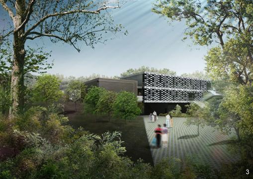
Perspectives of the Nature
Interpretation Centre, Multi-Cultural Education Retreat and Columbarium are
presented below:

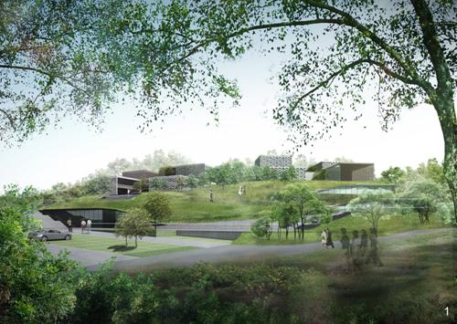
Perspective 1 - Nature Interpretation
Centre & Multi-Cultural Education Retreat
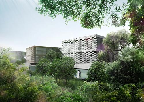
Perspective 2 – Staff Quarter in the Multi-Cultural Education
Retreat
Perspective 3 - Columbarium
A detailed description of each
of the uses within the Development Site is as follows:
Nature
Interpretation Centre
The Nature Interpretation
Centre accommodates the administrative and operational functions of the
conservation management and educational facilities relating to the adjoining
Conservation Area. It comprises four inter-linked
levels stepped down in line with the existing topography (refer to Figure 3.7). As
this facility is not part of the development concession because it is essential
to the conservation intent, it is located closest to the public parking area
and entrance to the Ecological Reserve.
The building, which will have a GFA of around 1,700m2, will
have a distinctive architectural design reflective of its public educational
nature and which will respect its surroundings.
A detailed description of uses in the Nature Interpretation Centre will
be provided in the s12A Application under the Town Planning Ordinance.
Parking
Area
The proposed parking area at
the end of the
Multi-Cultural
Education Retreat
The primary objective of the Multi-cultural Education Retreat
(MCER) is to provide a rural venue for promoting spiritual education and
guidance operated by a registered non profit making organisation. Thereafter the MCER will be a non-profit
making operation. The Retreat, which
complements and is contiguous with the Columbarium use, and its structures are aligned north /south to follow the natural
landform. The concession comprises two
low rise structures - the main building of the MCER
accommodates the main halls of worship (where previously an informal burial
ground by local villagers existed), as well as facilities
for lectures, seminars, library and administration, while the ancillary quarters consists of four linked buildings of 3
storeys. The ancillary quarters will provide accommodation (about 16 rooms) for
masters and trainees of the retreat only.
The total GFA of the whole MCER
(including ancillary quarters) is around 4,800m2. Again these structures are designed to be of
low-impact not only in terms of construction impact but also visually. The roof structures do not exceed +205mPD
(the height of the existing knoll) and are stepped down in line with the natural
terrain. The design is respectful of the
rural setting by minimising building bulk and height and provision of extensive
new planting around the structures (see Figure 3.7). It also environmentally sensitive development
in being respectful of the existing topography, having natural ventilation and
being positioned southwest of existing higher value woodland adjacent to the
20m wide buffer area and country park.
The MCER is accessed directly from the parking area and to the
Columbarium site.
The
Columbarium
The primary intention of the Columbarium is to serve the
remembrance needs of inter-denominational demand in the
The Columbarium will
accommodate up to 60,000 niches in four pairs of inter-linked three-storey high
structures with flat landscaped roofs.
The structures are arranged in pairs around a quiet, landscaped garden
enclosure in which water features will provide an appropriate meditative
ambience and auditory context for the remembrance rituals. No effigies will be permitted to be burnt at
the Columbarium with patrons instead encouraged to make fruit offerings – which
is a traditional Buddhist practice. The
structures are located on the lowest eastern side of the knoll so as not to be
visible from the road and are linked at both ground and upper levels by paths
connecting to upper and lower walkways leading to and from the new parking area
at the upper end of
3.4.4
Preliminary Construction Activities of the
Development Site
The major construction work for the Development
Site will include the following key activities:
-
Site clearance and grave
relocation;
-
Site formation & drainage
works
-
Slope stabilization works;
-
Superstructure and building
construction; and
-
Landscaping works.
The construction activities will be carefully
designed to avoid ecological impacts to the nearby Conservation Area,
·
Minimise the building footprint
within the Development Site, occupying only 1.27 ha of building footprint
(excluded site formation and landscaping areas (ie
cut slope, formed platform, pavilion and gathering area which may comprise up
to approximately 0.46 ha)) out of the 4.1 ha Development Site (comprised only
about 31.0% of the total site area).
·
Provide a minimum of 20 m
additional buffer area off the existing SSSI zone in order to further safeguard
the Sha Lo Tung Stream which has been preserved by the existing generally 30 m
buffer areas (designated under the SSSI zone).
The construction works are hence generally of 50 m from any stream
course within the Sha Lo Tung SSSI;
·
Careful site developments to
avoid encroachment and possible construction runoff to the sensitive stream
course within the Sha Lo Tung SSSI at northern side of the site;
·
Minimise the permanent and
temporary cutting areas;
·
Minimise the footprint of the
temporary access road within the site;
·
Divide the works into three
stages to minimise the concurrent works within the site (Sha Lo Tung Road
improvement with its drainage network will be completed prior to any
construction works undertaken within the Development Site);
·
Start with the construction at
southern side to minimize any impact to the ecological sensitive stream to the
north of the site.
·
Undertake earthworks (soil
excavation and filling works) during the dry season (November to March);
·
Provide well designed temporary
drainage systems around the entire Development Site in advance in order to
ensure no construction runoff discharge to Sha Lo Tung Stream and Conservation
Area;
·
No encroachment to Conservation
Area and
·
No restaurant will be
constructed in the Nature Interpretation Centre, and a Multi-Cultural Education
Retreat cum Columbarium.
·
No night time construction
works within the Development Site.
3.4.5
Conceptual Site Formation and Construction
Works for Key Infrastructure
The site formation plan is presented in Figures 3.11 and 3.12. The site office will be located in the
southern part of the Development Site at a substantial distance of at least
350m from Sha Lo Tung SSSI and streams.
Most formation works will involve cutting existing slopes to provide
sufficient space for constructing superstructures within the Development Site. In order to avoid adverse environmental impacts
to the surrounding landscape and ecology during the site formation works, the
proposed construction methods will minimize the permanent and temporary cutting
required.
The permanent drainage for surface runoff
will be constructed along the road and water storage tank of capacity about 30
m3 will be constructed under the proposed carpark
when the carpark is formed (Figure 3.7). The required size of the main storage tank
has been significantly reduced by the decision to isolate, collect and
discharge the access road and car park stormwater
run-off within the site by pumping back to the existing system (details refer
to Annex C). The
storage tank will be a steel structure of minimum 30m3
capacity. It is intended to be at least
2 m deep to allow efficient access for inspection and maintenance and will
incorporate a 300 mm free board in the final design. The tank will also have an orifice outlet
control with inlet and outlet sluice valves for isolation and maintenance
activities. The tank will also be
designed to house a pump to accommodate the unlikely event that the contents of
the tank are required to be pumped off-site
The sewer will be constructed along the improved
It is anticipated that approximately
16,100 m3 of excavated materials will be generated and approximately
7,600 m3 filling materials will be required for the site formation
works. The breakdown of estimated amount
of cut / fill material of each stage of works are listed in Table 3.4. The cutting and filling activities for the
site formation and slope works will be planned and arranged in such a way that
the requirement for stockpiling will be minimised.
Table 3.4 The breakdown
of estimated amounts of cut / fill material of each stage of works
|
|
Stage
1 |
Stage
2 |
Stage
3 |
Total
Volume (cu. m) |
|
Fill material (cu.m) |
5,800 |
1,100 |
700 |
7,600 |
|
Excavated material (cu.m) |
3,600 |
11,300 |
1,200 |
16,100 |
The site formation plan with the extent of cutting
and filling works is shown in Figures 3.11 & 3.12. To minimize disposal of excavated material
off the site area, the excavated material is designed for re-use as filling
material within the site as far as possible.
The excavated material should be used to form the platforms for the
columbarium buildings and the associated facilities. The remaining excavated material can then be
considered for re-use as top soil for the butterfly garden and tree planting
proposed in the Ecological Reserve.
Should there be any requirement for the temporary
storage of excavated materials destined for reuse within the Project, the
stockpile of such materials will be placed within a designated area measuring
about 3m x 20m in the southern part of the Development Site (Figure 3.11).
The designated stockpile area will occupy a passing bay constructed
within the first stage of construction and is located at a substantial distance
of approximately 320m from Sha Lo Tung SSSI and streams. The area will be on concrete access road, which
provided with concrete bunds and interceptor drains along its perimeter to
prevent the loss of materials such as soil, silt or debris to the surrounding
area. The stockpile will also be covered
with tarpaulin or similar impermeable covering materials during rainstorms to
ensure that no impact on the water gathering ground, Sha Lo Tung SSSI and
streams will arise. All unavoidable
surplus excavated materials will be removed from the works area and delivered
by truck on a daily basis to one of the Government’s public fill reception
facilities, eg Tuen Mun Area 38 Fill Bank.
The trucks will only travel along the improved
The chemicals stored for use
during building construction will include paints, varnishes and the like for
application to steel, timber and plywood formwork, concrete additives, solvents
and thinners, adhesive, bituminous compounds and tars. Since they will be stored in small quantities
and will be properly stored,
collected and treated for compliance with Waste
Disposal Ordinance or Disposal
(Chemical Waste) (General) Regulation requirements. All fuel tanks and chemical storage areas will
be provided with locks and be sited on paved areas and located next to the
temporary stockpiling area at the south of the Development Site (Figure 3.11).
The storage areas will be surrounded by bunds with a capacity equal to
110% of the storage capacity of the largest tank to prevent spilled oil, fuel
and chemicals from reaching the receiving waters. As such, the risk of the chemical spillage to
the water sensitive receivers, especially the WGG, is expected to be low. The storage area will be located at the
southern side and the lower part of the Development Site to provide at least
320m buffer distance from the SSSI and Sha Lo Tung Stream.
Endeavours will be made to adopt local trimming in
association with the provision of soil nailing to form the platform required
for the construction of permanent structures.
In-situ excavated materials will be reused as far as practical, for
backfilling. In order to reduce the
visual impact, the slope will be engineered as naturally as practicable. Soft landscaping solutions will be adopted
for surface protection on the slopes where geotechnical conditions allow. Hard surface protection cover such as shotcrete will only be considered as the last resort. Surface protection and surface drainage are
proposed to form part of the slope stabilization works. The surface protection cover aims at reducing
infiltration and erosion caused by heavy rainstorms. The slope drainage system shall collect
runoff from both the slope and its corresponding catchment areas and lead to
convenient points of discharge beyond the limits of the slope.
For the proposed low-rise structures and buildings,
different floors are proposed to rest on ground at different levels at stepped
pattern. In light of the relative light
weight of each floor, the foundation is expected to be raft foundation or pad
footings. Superstructure construction
will last for approximately 12 months and for the first 6 months this will be
implemented in parallel with the Stage 3 site formation works (refer to Section 3.6.3). Works including E&M, architectural,
drainage, utilities and landscaping will be conducted after the completion of
site formation.
3.4.6
Proposed Temporary Drainage within
Development Site during Construction Works
There are two key objectives of the temporary
drainage system:
1. to ensure construction runoff entirely
contained within the construction site; and
2. to ensure no
construction runoff discharge to Sha Lo Tung SSSI Stream and avoid impacts to
water quality and the associated aquatic fauna, in particular larval stages of
the dragonfly community.
In order to achieve the objectives listed above, two
separate drainage systems, including (1) Peripheral
Temporary Drainage Channels
and (2) Separate Temporary Drainage System for Natural Runoff,
plus additional Site Hoarding and Chain-link Fence with Seal, will be provided (Figure 3.11). In according with Section 8.2.4 of Geotechnical Manual for Slopes, the design of the
temporary drainage system shall be 1 in 10 years return period, after taking
into account of the importance of site, a conservative approach of 1 in 20
years return period was adopted.
Peripheral
Temporary Drainage Channels
During construction, to prevent the silty surface run-off discharging to the nearby
environmental sensitive areas, all the surface run-off will be collected by the
temporary drainage system and then discharged to the newly constructed stormwater drainage system along
A sand trap of adequate capacity and retention time
is proposed to connect between the temporary drainage system within the site
and the newly constructed stormwater drains beneath
Due to the lower level at the surface runoff
collection point within the Development Site, the construction runoff collected
by ditch/ channel within the Site will be discharged to temporary storage tanks
in which a submersible pump will operate to continuously pump the surface
runoff to the proposed sand trap. Dual
power supply or ring main supply will be used in case of electricity breakdown. On the other hand, there is an additional
spare submersible pump to ensure continuous pumping out of surface runoff when
the working pump fails to work. The
capacity of the spare submersible pump will be 110% of that of the working pump
for contingency purpose.
Site
Hoarding and Chain Link Fence with Seal
In the
event of a rainstorm exceeding 1 in 20 year return period, excessive surface
runoff will still be contained within the Development Site by the erection of
site hoarding and chain-link fence with seal.
Site hoarding and chain-link fence will be erected along the temporary
drainage system enclosing the whole Development Site (refer to Figure 3.11).
The foundations of the hoardings and fence should be erected firmly
attached to the channel (any gaps are to be filled and cemented) in order to
avoid any accidental spilling over the peripheral channel to the nearby
streams. All of the excessive runoff due
to heavy rainfall or overflow of storage tanks/ sand trap could be retained
within the Site thereby avoiding accidental discharges into the Sha Lo Tung
SSSI Stream. The erection of the
hoardings should avoid any additional impacts to the existing trees.
To minimize the potential construction impact to the nearby
habitats (in particular secondary woodland and wet
abandoned agricultural land at the northeast of the Development Site), chain-link fence, instead of hoarding
will be proposed along areas of steep slope (please refer to Figure 3.11). As the excavation work for the
chain-link fence and required working area is much less than that for the
hoarding, the construction impact to the nearby habitats as well as the
potential impacts to the existing slopes should be greatly reduced. To further minimize the potential
construction impact, the following precautionary measures or site practices
will be adopted.
·
Erection of chain-link fence/
hoarding shall be commenced in dry season;
·
Excavation for the foundation
of the chain-link fence/ hoarding will only be carried out behind the
chain-link fence/ hoarding to avoid possible construction debris flowing
outside the Development Site and into the existing secondary woodland and wet
abandoned agricultural land at lower level;
·
Prior to the excavation of the
foundation of the chain-link fence/ hoarding, sand bags shall be placed in
front of the chain-link fence / hoarding alignment to prevent any construction
debris or construction runoff flowing into the existing secondary woodland and
wet abandoned agricultural land at lower level (outside the Development Site);
·
The excavated materials
generated from the foundation works of the chain-link fence/ hoarding will be
filled into empty sand bags immediately so as to avoid uncontrolled storage of
spoil. All other sorted C&D wastes
will be disposed off-site;
·
Any gaps at the base of the
chain-link fence/ hoarding shall be filled by sand bags or other sealing
materials.
Separate
Temporary Drainage System for Natural Runoff
To cater for the surface water running from the large
catchment area of natural terrain at the southern and south-eastern sides to
the low profile of the site, a separate temporary drainage system including catchpits and drainage pipes is proposed to direct the
hinterland surface runoff without flowing across the site and resulting in any
contamination due to site activities to the north side of the site.
To follow the natural topography, a temporary
diversion scheme is proposed which are shown on Figure 3.11. This route would be aligned around the actual
works area. If considered necessary, a
strip of reinforced concrete encasement along the pipe is to be provided as to
prevent any damage due to the superimposed loads. Before the permanent drainage system is in
operation, this temporary pipeline will direct the hinterland surface runoff
without flowing across the site. This
route has been aligned in such a manner to avoid the existing trees being
affected at the concerned area.
3.4.7
Tentative Construction Methods, Programme
and Plant Inventory
Earthworks will only be undertaken during the dry
season (November to March). Table 3.5 summarises the construction methods
and plant inventory for the site formation and superstructure works at the
Development Site.
Table 3.5 Construction
Methods and Plant Inventory for the Site Formation and Superstructure Works
(Tentative)
|
Development Site |
Types of Works |
Construction Method |
Workers Required |
Plant Inventory |
|
Site Formation |
Earthworks (soil
excavation and filling works) |
Bulk excavation will be
conducted using excavator whilst hand-held tools will be used for minor
trimming works. Filling works will
involve placing suitable filling material on slope and proper compaction by
vibrator. |
8 nos. |
Excavation works: 3 nos.
excavators; 4 no. trucks Filling works: 1 no.
Pneumatic roller |
|
Retaining walls |
Reinforced concrete l-shaped
cantilever retaining walls will be constructed at the slope toe of several
areas. In addition, retaining walls
will be construction at the back of each columbarium building in association
with the platforms behind the buildings.
There will be steel fixing, erection of formworks and concreting. |
6 nos. |
1 no. concrete mixer
truck; 1 no. delivery truck; 1 no. concrete pumps; 1 nos. generators; 2 nos.
vibratory pokers. |
|
|
Foundation works |
Foundation works will follow
after temporary site formation works.
Shallow foundation, e.g. pad footing, will be the main type of
foundation structures for the development and it shall mainly involve steel
fixing and concreting. |
10 nos. |
1 no. concrete pump; 1
no. generator; 2 nos. vibratory poke; 1 no. bar bender and cutter |
|
|
Drainage |
Trench excavation for
drainage works and laying underground pipeline will be conducted using
hand-held tools. Surface channels will
be cast by fresh concrete. |
6 nos. |
1 no. excavator; 1 no.
concrete mixer; 1 no. concrete pump; 1 no. vibrating poke |
|
|
Slope Improvement Works |
Drilling for soil nails
will be conducted using rotary drill with air as the flushing medium by
portable drilling tools, followed by installation of steel bar and
grouting. The approximate size of
drill holes is 0.15m diameter.
Portable drilling rigs will be placed on secure temporary platforms
and scaffolding. |
10 nos. |
2 nos. drilling rigs; 2
no. air compressors (900cfm/ 14 bars); 1 no. grout pump with mixer; 1 no.
generator |
|
|
Superstructure Works |
- |
Reinforced concrete
(steel fixing, erection of formwork and concreting) |
16 nos. |
2 nos. Mobile/Crawler
cranes; 2 nos. air compressors; 1 no. concrete mixer truck; 1 no. delivery truck;
2 nos. concrete pumps; 2 nos. generators; 4 nos. vibratory pokers; 1 no. bar
bender and cutter; 1 no. water pump; 1 no. submersible pump |
|
|
|
Steelwork (steel
erection, connections, welding) |
8 nos. |
1 no. Mobile/Crawler Crane;
1 no. air compressor; 1 no. generator; 1 no. delivery truck |
To ensure that construction traffic will operate
smoothly within the Development Site and to obtain an optimal programme of the
works, the Development Site will be divided into 3 sub-areas with an overall 3
stages of works (Figure 3.13). The 3 sub-areas are described as follows and
the 3 stages are discussed in Section 3.6:
Sub-area
1
Sub-area 1 is located at southern side of the site in
which columbarium structures are situated at various platform elevations
ranging from +196.5 mPD to +206 mPD. The area of cut is more or less the same as
filling.
Sub-area
2
Sub-area 2 has structures of the Multi-cultural
Education Retreat, which sits on platforms at +182.0 mPD
to +196.5 mPD and is located next to the 20m buffer
building line boundary of the site.
Sub-area
3
Sub-area 3 including Nature Interpretation Centre and
carpark is located at the western corner/ entrance
& exit of the Development Site. The
level difference of construction platforms of these structures is about 13 m
(i.e. +185.33 mPD to +198.25 mPD).
Details of the construction programmes and
construction sequence are discussed in Section
3.5. The construction period will
require a total period of 42 months for the whole construction works, in which
19 months will be required for the road improvement works. Construction works will mainly arise from
small powered mechanical equipment (PME) operating at the site and no piling
works will be required. Earthworks will
only be undertaken during the dry season (November to March).
It will be beneficial to start site preparation works
before the dry season (ie in July) so that the major
earthworks (soil excavation and filling) can be managed to be executed in the
following dry season so that ecological impacts from the construction works can
be minimised.
Daily Cleaning and Weekly Tidying of the Site
including the Public Cleaning Areas will be performed. The extent of the Public Cleaning Areas
required for cleaning are deemed to be within 2.5 metres on the periphery
outside the barriers or hoardings.
“Daily Cleaning” includes cleaning and tidying up
after work of tools, equipment, unused materials, storage areas and common
areas such as passageways, daily removal of waste materials from works areas,
removal of any rubbish and debris dumped into the Site by the public.
“Weekly Tidying” includes the cleansing and tidying
up of the common areas and accesses, cleansing and/or re-conditioning of
hoardings, barriers, guarding, lighting, signage and/or traffic cones,
cleansing of external covers for plant and equipment, removal of waste and
debris etc. so as to ensure that the plant and equipment, hoardings, as well as
such Site as a whole, to be clean and tidy in the perspective of the general
public.
3.4.8
Operation of the Development Site
During the operation of the columbarium, burning of effigies and paper offerings in the Development Site will be
prohibited. Such prohibition covers all
locations in the Site including the Columbarium, Multi-cultural Education
Retreat and open space. Limited burning
of incense and candles will be allowed only within the MCER on special
supervised occasions with only one incense lit within
the complex at all times. The total
number of occupants residing on site is not expected to be more than 30. The occasional visitors to the Nature
Interpretation Centre, Multi-Cultural Education Retreat cum Columbarium are expected
not to be more than 200.
SLTDC will provide a shuttle bus to serve visitors to
visit the columbarium which will help to reduce the traffic flow along the
improved
Regarding the operational traffic, the proposed
development is expected to induce a maximum peak hour two-way traffic of 36 pcu/hour and 61 pcu/hour on a
typical weekday and a Sunday, respectively (details refer to the Traffic Impact
Assessment in Annex D).
Designs of the Multi-Cultural Education Retreat and
Columbarium (by provision of fencing and landscape planting) will manage
visitors’ activities within the site and encourage them not to wander into the
Ecological Reserve, particularly during festival days.
The wastewater generated on site will be discharged
into the sewer connected to the public sewer at
Application of pesticides, insecticides and chemical
fertilizers for the landscaping purpose and vegetation maintenance will be
prohibited during operation. Should
organic fertilizers be used for encouraging the growth of planted vegetation,
prior approval from the relevant authorities will be required.
The 60,000 niches will be sold in not less than 3
phases in 6 years, not more than 20,000 niches in each phase. Before proceeding to each selling phase, the
traffic management measures will be reviewed and reported to the relevant
authorities, and revised as required by the relevant authorities. There will be two classes of niches, namely
Class A and Class B:
·
For Class A (20,000 niches in
total), the buyers may visit the columbarium at any time, but prior booking
will be required during the Festive periods (Festive periods means Ching Ming
and Chung Yeung Festivals and its immediate week-ends). Passes will be issued by the proponent
beforehand. Only people holding the
passes will be allowed to take shuttle buses (provided by the proponent) to
travel up to the columbarium. When
people arrive at the columbarium, the passes have to be returned to the
columbarium management office. The
proponent will provide people to check passes.
·
For Class B (40,000 niches in
total), the buyers will not be allowed to visit the columbarium during the
Festive periods. Their niches will be
locked up/covered during those periods.
The proponent will provide people to check for Class A passes and remind
visitors at the junctions of
Prohibition of burning of effigies, paper offerings, candles
and incense would be set out clearly in the sales and purchase agreement for
buying the niches. Staff would be
stationed to enforce the rules and in-house management measures such as signage
would be put in place to remind visitors.
3.4.9
Risks of Landslides
The proposed Development Site is surrounded by
environmentally sensitive areas such as Sha Lo Tung SSSI, Fung Yuen Valley SSSI
and
Risks
of Landslides during Construction Phase
In the event of slope failure during the construction
phase, site runoff which contains sand, silt or other suspended material /
failure debris is the main potential environmental impact to adjacent stream
habitat arising from the Development Site.
The safety factors required for the design of temporary works (i.e.
temporary trimming undertaken during construction which are not part of the
permanent works) will be the same as those for permanent new works (as Table 1 of WBTC No. 13/99 and
Geotechnical Manual for Slopes), but with regard to the conditions which are
likely to exist during the life of the temporary works. Apart from observing the criteria of current
geotechnical standard in design of temporary works, measures to increase the
robustness of slopeworks or reduce the risk of
landslides during construction within the development site will be implemented
as follows:
Restrict earthwork activities within the development
site such as excavation and filling to the dry season months of November to
March inclusive.
Phase the works in a manner that reduces the area of
exposed earthworks to a practical minimum at any time, for example the road
improvement works will precede and be completed before the Development Site
earthworks commence. Exposed slopes will
be covered, paved or hydro-seeded as soon as possible after completion to guard
against surface erosion during heavy rainfalls.
Provide, in advance of the main earthworks, a
temporary drainage system comprising concrete channels and site hoardings with
sand bags along the low side of the road widening works and around the
perimeter of the Development Site works area to trap runoff and convey it for
treatment (refer to Section 6 for
details).
Provide silt and oil removal facilities in the form
of oil interceptors and sand traps and convey site runoff to existing drainage
outside the Development Site. Since the
Development Site is below the crest of
Reduce the volume of site runoff requiring treatment
and pumping by intercepting overland natural surface run-offs from upslope
hinterland areas and separately conveying these surface run-offs to existing
water courses.
Carry out regular on-site inspections and spot checks
by a competent geotechnical person having the authority to stop works if the
above control measures are not being implemented effectively.
Set up an emergency team comprised of project
manager, site engineer, contractor’s site agent who can call up gangers to
carry out emergency repair works (i.e disposal of
failure debris/material) in the event of slope failure within short period of
time and make sure the team members can be reached at emergency.
Where carrying out construction involving earthworks
during the dry season, containing runoff within the site, treating it before
discharge and diverting up slope runoff away from the site are to be put in
place on site, risk of landslip within the site can be largely reduced and thus
pose minimal impact to the adjacent ecological sensitive streams.
Risks
of Landslides during Operation Phase
It is expected that where existi
Proper maintenance prevents the deterioration of
slopes within the site. In addition to
regular maintenance during operation, routine inspections by a chartered
engineer and enhanced maintenance using prescriptive measures (GEO Report No.
56) as appropriate shall be carried out to achieve quick improvement to the
stability of existing non-engineered slopes within the development site. The
frequency of these routine inspections shall make reference to Geoguide 5: Guide to Slope Maintenance.
During occupation of the development buildings the
risk of landslide should be very low and can be effectively reduced through
good design and construction of slopeworks as well as
proper maintenance.
3.5
Sha
Lo
3.5.1
Alignment of the Sha Lo
The existing
·
for public and private vehicles
whose passengers visiting the surrounding
·
for visitors and in particular
coaches and school bus visits and service vehicles to the Nature Interpretation
Centre and Ecological Reserve
·
for fire and other emergency
vehicles;
·
for shuttle bus services (on
festival days) and other private vehicles servicing the Multi-cultural
Education Retreat and Columbarium;
To meet the traffic demand during construction and
facilitate the transportation of construction plants or raw materials to/from
the Development Site, it is proposed to complete the road improvement works
with drainage and sewerage systems prior to commencement of site formation
works. The alignment of the Sha Lo Tung
Road Improvement (including proposed cut slope and potential soiling area) and
the investigation boundary (for the purposes of detailed engineering
investigation, the associated habitats and vegetation will not be affected) are
presented in Figures 3.14 and 3.15.
The design and engineering details of the Sha Lo Tung
Road Improvement have been developed following the principle presented in Section 2.4. The improvement scheme is generally described
Table 3.6 starting from
Table 3.6 Sha Lo
|
Chainage |
Design and Engineering details |
|
Chainage 0+100 to 0+300 (Figure 3.16) |
There are occupied lots
on both sides of the road, for example, the Fung Yuen Playground, the Society
for Horticulture of Hong Kong and private open storage. Other features affecting the improvement
scheme are a shrine and some mature trees along the roadside behind the
Society of Horticultural Hong Kong.
The road in this region is relatively flat. The section of the road
near |
|
Chainage 0+300 to 0+900 (Figure 3.17) |
The road begins to climb
at a gradient of 10% to 16%. Except at
Chainage 0+300 to 0+350, there is no private or
public lot near the edge of the road.
The western side is woodland of conservation importance and the
eastern side is generally plantation with a few rare plant species. The road will be widened towards the
eastern side through cutting the uphill slopes to avoid disturbing the
woodland on the western side. The cut
slope will be stabilised by soil nailing so that the slope surface can be
planted to maintain a green landscape after the improvement works are completed. |
|
Chainage 0+900 to 1+150 (Figure 3.18) |
In this section the
gradient of the road is mostly 8% to 16%, but exceeds 16% on a small
segment. This small segment will be
re-graded to lower the road gradient to less than 16%. Again, the western side
of the road is woodland. The eastern
side is a man-made slope, which is part of the WSD Ha Hang Fresh Water
Service Reservoir. Watermains
run under and alongside the access road.
Taking consideration of
the technical feasibility of diversion of existing buried water-carrying
services and the possible interruptions to these utilities due to the
proposed road improvement works, the latest as-constructed drawings provided
by WSD and the ecological impact on woodland along the west of the existing
Sha Lo Tung Road have been critically reviewed. According to the
as-constructed record plan, chainage from 1+040 to
1+118, at least one underground water pipe of 600mm diameter runs along the
immediate crest of the roadside slope, which has originally been proposed to
be trimmed for the widening the existing Sha Lo Tung Road. In order to avoid any disruption to the
integrity of the existing 600mm water pipe, the proposed work will eliminate
slope cutting, soil nailing and the diversion of the existing water main
within the area allocated to WSD but confine the road improvement works to
the opposite site of Further down the road
with chainage from 0+985 to 1+040 where the
distance between the existing Sha Lo Tung Road and the gravity wall of Ha
Hang Fresh Water Service Reservoir is more than 10m, the proposed road
improvement works will involve the construction of RC retaining wall founded
on minipiles at western side of the existing Sha Lo
Tung Road and minor trimming in association with soil nailing within the area
of WSD Service Reservoir. The minor
trimming works will only be considered provided that the horizontal net
clearance of at least 5m is provided between the proposed soil nail and the
gravity wall. This is to strike a
balance between ecological/environmental protection, necessity of road
widening and avoidance of any impact within WSD service reservoir. |
|
Chainage 1+150 to 1+230 (Figure 3.18) |
The gradient of the road
is mostly 8% to 16% in this section, which meets TPDM requirements. The west side of the
road is woodland on the downslope. The eastern side is occupied by the WSD Ha
Hang Fresh Salt Service Reservoir. The
Reservoir is about 10m away from the eastern edge of The proposed road
improvement in this section is to widen the road toward the east so as to
preserve the woodland on the west side.
The road will occupy part of the WSD area so discussions with WSD will
be needed during the detailed design stage.
Geotechnical work would involve cutting back the slope on the east
side. The existing topography suggests
that soil nailing may not be required.
New planting will be provided on the new slope face to restore the
green environment. |
|
Chainage 1+230 to 1+540 (Figure 3.19) |
The vertical gradient of
the road ranges mainly from 9% to 16%, but exceeds 16% in small portions of
the road. These small portions will be
re-profiled to reduce the gradient to 16% maximum. There are no land lot or restrictions of
land use along either side of this road section. The west side of the
road is a steep downhill slope covered by grasses and shrubs. The east side is grassland extending
uphill. The road would be widened
towards the east side because the west side is steep downhill slope. Slope cutting will be required and will be
stabilized by soil nailing. The new
slope face will be planted to blend in with the surrounding landscape. |
|
Chainage 1+540 to 2+100 (Figures 3.19 & 3.20) |
The west or downhill
side of the road is approximately 20 m upslope from the boundary of the Fung
Yuen Valley Site of Special Scientific Interest (Fung Yuen Valley SSSI). It is mostly covered with grass at areas
near the access road. There is no land
usage restriction on eastern uphill grassland of the road. Stormwater
channels cross beneath the access road at several locations. To ensure protection of
the SSSI, the road will be widened by cutting the uphill slope. The new slope will be stabilized by soil
nailing as in other parts of the improvement works. The existing facilities for natural stormwater will be modified to suit the improved access
road. For example, the existing earth
retaining structure serving the stormwater channel
at Chainage 1+660 will be strengthened and at Chainage 1+750, a small vehicular decking may be adopted
to cross over the existing channel. |
|
Chainage 2+100 to 2+437 (Figure 3.21) |
Here the access road
enters Sha Lo Tung Valley. To the west
is |
There will be no direct impact to
Construction wastewater is a concern that would be
addressed in three ways. First is to
limit the use of water in construction.
For example, generation of wastewater can be avoided by using
air-flushing instead of water-flushing to install soil-nails. Second is pre-treatment of waste water before
discharge. An example is the use of
sediment and grease traps to remove contaminants prior to discharge. Third is to avoid discharge of treated water
to ecologically sensitive areas, such as
3.5.2
Proposed Temporary Drainage during
Construction Works
As there is no engineered drainage system on the existing
road, it is necessary to construct drainage channels along the road. In accordance with Section 8.2.4 of Geotechnical Manual for Slopes, the design of
temporary drainage system was based on 1 in 20 years return period. The drainage channels will discharge the
surface runoff to the existing nearby dry valleys (considered as natural
drainage paths after rainfall). Several
drainage culverts are present beneath the existing road. The road improvement works will require
lengthening of these culverts. The
hydraulic capacity will be reviewed and the culverts will be upgraded as
necessary to ensure adequate design to prevent flooding on the improved road.
To prevent the discharge of silty
surface run-off to the existing watercourse, an effective temporary drainage
scheme will be introduced for the road improvement work. Prior to the construction, temporary hoarding
shall be erected and sandbags be placed at the toe of the hoarding within the
works site to prevent any silty water flowing out of
the works site. As shown in Figures 3.22 and 3.23, temporary sandtraps connecting with temporary surface drainage, will
be proposed at each phase of road improvement works prior to discharging into
the nearest natural drainage path to avoid any excessive sediment or
blockage of existing natural drainage system.
To avoid silty surface
runoff discharging to the environmental sensitive area with high ecological concerns,
ie Pat Sin Leng Country
Park, Sha Lo Tung SSSI and Fung Yuen Valley SSSI, all the collected surface
runoff during Phase 3 Road
Improvement Works would be discharged to the nearest natural drainage path
along Sha Lo Tung Road.
3.5.3
Tentative Construction Methods, Programme
and Plant Inventory
Construction works will be undertaken only during
normal working hours (ie 0700 to 1900 during Monday to Saturday (except general holidays) and no
construction work will normally be carried out outside of these hours).
Should evening and night works between 1900 and 0700 hrs or on public
holidays (including Sundays) be required, the Contractor will submit a CNP
application which will be assessed by the Noise Control Authority. Given this assumption, Figure 3.24 outlines
the preliminary works programme.
It will take approximately 19 months to complete the
road improvement works. For Phases 2 and 3 of the road improvement works, the slope works along these areas will
be carried out in the dry season (November to March) with an aim to avoid the
potential impact to the nearby protected areas like SSSI, sensitive stream
courses and
Construction equipment must be small and compact, and
easily transported along the site without using heavy lifting plants. This consideration will reduce the land area
required for construction, thereby limiting disturbance to the surrounding
environment, especially the
Table 3.7 Construction
Methods and Plant Inventory for the Road Improvement Works (Tentative)
|
Development Site |
Types of Works |
Construction Method |
Workers Required |
Plant Inventory |
|
Road Improvement Works
(Phases 1 to 3) |
Soil Nailing for
man-made slopes |
Drilling for soil nails
will be conducted using rotary drill with air as the flushing medium by
portable drilling tools and followed by installation of steel bar and
grouting. The approximate size of the
drill holes is 0.15m diameter.
Portable drilling rigs will be placed on secure temporary platforms
and scaffolding. |
20 nos. |
6 nos. drilling rigs; 2
nos. air compressors (900cfm); 2 nos. grout pump with mixer; 2 nos.
generators |
|
Concrete retaining wall
founded on minipiles (Phase 2 only) |
Minipile will
involve drilling within soil and rock using small piling rig and followed by
steel bars installation and grouting.
The approximate diameter of the drill holes is less than 0.3m
diameter. Drilling rigs will be
placed on secure temporary platforms and scaffolding. Concrete retaining structure will involve
erection of formwork, steel fixing and concreting. |
10 nos. |
Minipile
construction: 2 nos. drilling rigs; 1 no. air compressor; 1 no. generator; 1
no. grout pump with mixer RC wall construction: 1
no. concrete mixer; 1 no. concrete pump; 1 no. vibratory poke |
|
|
Earthworks |
Minor
excavation/trimming of soil slopes will be conducted using hand-held
tools. Where necessary, small
excavator will be deployed to facilitate the construction works. |
4 nos. |
Excavation works: 2
nos. excavators; 1 no. dump truck with grab Filling works: 1 no. vibro-compactor |
|
|
Road Works |
New pavement will be
constructed using hand-held tools.
Hand-held breaker will be employed to demolish the existing
carriageway. The construction of new
pavement will involve the erection of formwork, steel fixing and
concreting. Trench excavation for
drainage works and other underground utilities will also be conducted using
hand-held tools. |
20 nos. |
2 nos. breaker, 2 nos.
backhoe; 2 nos. concrete mixers |
The main solid waste produced is the excavated
material resulting from slope cutting.
The first principle in dealing with this is to minimise its
generation. As described above, use of
soil-nails would avoid unnecessary cutting, hence, limit unnecessary waste
generation. It is anticipated that
11,000 m3 of excavated materials will be generated and 1,000 m3
filling materials will be required for the road improvement works.
Any excavated materials to be reused within the
Project as fill for site formation will be stored in metal skips to ensure that
no impact on the water gathering ground will arise. All unavoidable surplus excavated materials
will be removed from the works area and delivered by a truck/dumper on a
regular basis to one of the government’s public fill reception facilities.
Daily Cleaning and Weekly Tidying of the Site
including the Public Cleaning Areas will be performed. The extent of the Public Cleaning Areas
required for cleaning are deemed to be within 2.5 metres on the periphery
outside the barriers or hoardings.
·
“Daily Cleaning” includes
cleaning and tidying up after work of tools, equipment, unused materials,
storage areas and common areas such as passageways, daily removal of waste
materials from works areas, removal of any rubbish and debris dumped into the
Site by the public.
·
“Weekly Tidying” includes the
cleaning and tidying up of the common areas and accesses, cleaning and/or
re-conditioning of hoardings, barriers, guarding, lighting, signage and/or
traffic cones, cleaning of external covers for plant and equipment, removal of
waste and debris etc. so as to ensure that the plant and equipment, hoardings,
as well as such Site as a whole, to be clean and tidy.
3.5.4
Operation of the Improved Sha Lo
Upon completion, the improved
Based on the traffic generation estimated in the TIA
Report, the total estimated 2-way traffic flow at Sha Lo Tung Road for the
worst case scenario (ie Sunday period) would be
expected to be not more than 120 pcu/hr
during the peak period (Annex D).
In addition, stormwater
drainage system and twin sewerage rising
mains will be present along the road.
3.6
Indicative Works Programme and Construction Sequence
of the Project
The
works programme of the Project is shown in Figure 3.24 and the work sequence
of the Project will be undertaken as follows:
·
Ecological Reserve
·
Sha Lo
·
Development Site
3.6.1
Ecological Reserve
The enhancement work will be undertaken immediately
the Project is agreed amongst the three partners (The SLTDC, Green Power and
the Government) and the land exchange is successfully concluded, to provide the
greatest conservation and ecological benefit.
The Conservation Management Plan and the priority of the enhancement
work shall be approved by the Government statutory fund prior to the
commencement of the enhancement work.
The enhancement work may last for several years subject to the regular
evaluation of the effectiveness of the associated work.
The minor improvement of footpath, construction and
installation of the temporary footbridge and fencing around broken village
houses and structures at Lei Uk will be completed
within 3 months (during dry season).
3.6.2
Road Improvement Works
Before any construction works are undertaken within
the Development Site,
In order to avoid the prolonged disturbance to the
surrounding areas, in particular to the Water Supplies Department (WSD) Ha Hang
Salt and Freshwater Service Reservoirs as well as the protected areas in the
vicinity of Sha Lo Tung Road including Fung Yuen Valley SSSI, Pat Sin Leng Country Park and Sha Lo Tung SSSI, the road
improvement works between Ting Kok Road and Sha Lo
Tung Valley will be divided into three phases which are presented in Figure 3.22.
Each phase of the road works (approximately 800m long) will be
constructed generally in sequence with each will overlap at certain periods of
time and take approximately 8 to 9 months.
Phase 1 Slope Improvement Works (Soil Nailing + Local
Cutting)
·
Phase 1 will take approximately
8 months to complete. Preparation works
e.g. hoarding erection, site clearance, plants mobilization, and temporary
traffic arrangement will be conducted for the first 4 months. The cutting and soil nailing works will be
undertaken at the onset of the dry season (i.e. November to December);
·
One-third of this section of
works (near
·
The rest of this section will
be widened towards the eastern side through cutting the uphill slopes to avoid
disturbing the woodland on the western side.
The cut slope will be stabilized by soil nailing so that the slope
surface can be planted to maintain a green landscape after the improvement
works are finished.
Phase 2 Slope Improvement Works (Soil Nailing + Local Cutting
+ Concrete Retaining Wall supported by Minipiles)
·
Phase 2 will last for about 8
months and 2 months will overlap with Phase 1.
This section of works will involve installation of minipiles,
soil trimming and construction of retaining wall and this will be undertaken
within the dry season (November to March) to avoid any contaminated surface
water flowing to existing watercourse nearby.
·
A portion of this section is
part of WSD Ha Hang Fresh Water Service Reservoir. Watermains runs
under and alongside the access road;
·
In order to avoid disturbance
to the existing main, the road will be widened toward the western or the
downhill side of the access road.
Retaining walls of around 3m height will be constructed along the west
edge of the access road. These walls
will be supported by minipiles so that the road
improvement will not affect the stability of the downhill slope. The construction plant for minipiles is small and compact and is suitable for the
limited working area; and
·
Beyond the WSD Reservoir area
along the road, the road would be widened towards the east side because the
west side is steep downhill slope.
Geotechnical works for this portion will involve soil nailing and
cutting.
Phase 3
Slope Improvement Works (Soil Nailing + Local Cutting)
·
The final phase of road
improvement works and will start from the tenth month after commencement of
works and will take approximately 9 months (starting from 11 months after
commencement of works) to complete. Soil
trimming and soil nailing are planned to be complete within 4 months and by the
end of the dry season. The road works
will then follow;
·
The west of downhill side of
the road is approximately 20 m from the boundary of the Fung Yuen Valley
SSSI. Stormwater
channels will be formed and cross beneath the access road at several locations;
·
To avoid any disturbance to the
SSSI, the road will be widened by cutting the uphill slope on the east side and
stabilized by soil nailing as in other parts of the improvement works; and,
·
The remaining portion of the
access road runs between Sha Lo Tung Development site and
The road improvement work will take approximately 19
months to complete.
3.6.3
Development Site Construction Works
The logistic of the site are of prime importance for
achieving the overall programme within the timeframe for completion. Three stages of the site formation works are
proposed (see Figure 3.13) and are described
as follows:
Stage
1 (approximately 6 months)
·
Site clearance
·
Road improvement works along
western boundary
·
Temporary drainage works
·
Construction of transporting
route and disposal facilities
·
Site formation works at columbariums (Sub-area 1)
·
Slope stabilization works
Stage
2 (approximately 5 months)
·
Temporary drainage works
·
Construction of transporting
route and disposal facilities
·
Site formation works at
Multi-cultural Educational Retreat (Sub-area 2)
·
Slope stabilization works if
any
Stage
3 (approximately 6 months)
·
Temporary drainage works
·
Construction of transporting
route and disposal facilities
·
Site formation works at Nature
Interpretation Centre (Sub-area 3)
·
Slope stabilization works if
any
The duration of each of the three stages will overlap
at certain periods of time, so that the earthworks (soil excavation and filling
works) will only be undertaken during the dry season (November to March). The construction works for Stages 1 to 3 will
take approximately 12 months to complete.
At the beginning of the site formation works, a
temporary drainage system will be introduced to prevent silty
water flowing out of the works site (Figure 3.13). Sub-area 1 construction (i.e. columbarium at
eastern side of the site) will take place during Stage 1 of the site formation
works. A transportation route will be
established in-between columbarium for transporting excavated / filling
materials as well as portable construction plants. Stage 2 solely involves site formation at
Sub-area 2 (i.e. Multi-cultural Education Retreat). Transportation route / disposal facilities
will be constructed to connect the construction area in Stage 1. Sub-areas 3 which are quite close to the Sha
Lo Tung SSSI and Stream will be carried out at a later stage (Stage 3) in order
to minimise the duration of soil exposure taking place close to the SSSI and
the stream. It is expected that the site
formation works will be completed by the onset of the wet season which is
considered to be a strong commitment to reduce the risk of water quality and
ecological impacts to the adjacent SSSI and natural stream.
Superstructure construction, E&M, architectural
features, drainage, utilities and landscaping will be carried out after
completion of the site formation works.
The Fung Yuen Residential Development and
associated road works are currently ongoing.
The project works fall within the Study Area but are expected to be
completed when the current Project construction works commences and therefore
no concurrent projects are anticipated.
It should also be noted that the
construction of the Development Site and Sha Lo Tung Road Improvement would not
be undertaken concurrently, as the existing
3.8
Special Arrangement during the Festival Days (during
Operation Phase)
3.8.1
Visitor Arrangement
During the Ching Ming Festival and Chung Yeung
Festival, there will be special arrangement to minimise the environmental
impacts as well as the human disturbance to the surrounding sensitive areas
such as SSSI, country parks and Sha Lo Tung Stream.
The Nature Interpretation Centre will also be closed
during those days to avoid attracting people wander within the Ecological
Reserve.
Designs of the Multi-Cultural Education Retreat and
Columbarium (by provision of fencing and landscape planting) will manage
visitors’ activities within the site.
Although
The number of visitors will be controlled by
categorising the niches into two classes, namely Class A and Class B:
·
For Class A (20,000 niches in
total), the buyers may visit the columbarium at any time, but prior booking
will be required during the Festive periods (Festive periods means Ching Ming
and Chung Yeung Festivals and its immediate week-ends). Passes will be issued by the proponent
beforehand. Only people holding the
passes will be allowed to take shuttle buses (provided by the proponent) to travel
up to the columbarium. When people
arrive at the columbarium, the passes have to be returned to the columbarium
management office. The proponent will
provide people to check passes.
·
For Class B (40,000 niches in
total), the buyers will not be allowed to visit the columbarium during the
Festive periods. Their niches will be
locked up/covered during those periods.
The proponent will provide people to check for Class A passes and remind
visitors at the junctions of
Further to the above arrangement, it is expected that
the maximum accumulation number of visitors, within a 2 hour period, is about
2,500 and maximum 7,400 visitors per day will be allowed to enter the
columbarium (the estimation of the visitor number refers to Section 7) during Ching Ming and Chung
Yeung Festivals. SLTDC will restrict the
maximum number of visitors during Festive periods not more than 7,400 visitors
per day (ie through administrative arrangement). To provide resources required for the traffic
management and crowd control, including but not limited to, a maximum of 50
trained personnel (inclusive of first-aid service) will be participated, and
the maximum capacity of twenty 24-seater shuttle buses (as vehicles exceeding
5.5 tons would still be restricted to use the future Sha Lo Tung road,
according to Transport Department) will only be allowed to operate along Sha Lo
Tung during the Festive periods. During
the festival days, the proposed development is expected to induce a maximum
2-way traffic flow of 100 vehicles per hour which is the traffic flow design of
the proposed road improvement at
During the Festive periods, only the proponent’s
shuttle buses and emergency vehicles will be allowed to use
3.8.2
Sewerage Facilities Arrangement
The wastewater generated on site will be
discharged into the sewer connected to the public sewer at